THE BOOK OF NATIONS Geographical, Historical, Descriptive (continued 8)
Reading edition
Passing into France, and across the broad river basins of its lowlands which open to the English Channel and the Bay of Biscay, we come upon the great wine-yielding lands, such as Champagne and the vineyards of the Gironde, with the corn country of Brie northeast of Paris, and of Touraine, on the Loire between these; and lastly, at the extremity of this branch of the European plain, to the Landes along the coast between the mouth of the Gironde and the Pyrenees, composed of sandy heaths and marshes.
ISOLATED LOWLANDS OF EUROPE
Of these, two of large extent occur in the basin of the river Danube, separated by the gorge of the “Iron Gate,” formed where the Balkan and Carpathian ranges approach most closely. The upper plain, circled about on all sides by mountains, is that of Hungary, over which corn fields interchange with pastoral steppes well stocked with horses and cattle, sheep and swine, merging in some parts into marsh lands or into dusty sand flats. Where the plain begins to rise to the sunny hills, the Hungarian grape ripens to yield its famous wines. The lower plain of the Danube, which might be called a branch of the vast Russian lowland, is that of Roumania, with its far-stretching treeless heaths and pasture lands supporting great herds of cattle and horses, passing into wide reed swamps which characterize the delta of the Danube.
Corresponding to the Roumanian plain is that of Lombardy, perhaps the most productive region of Europe, in which the irrigated meadows may be six times mowed in the year, and where wheat, maize, and rice, and wine and dairy produce, are yielded in vast quantity.
MOUNTAINS AND HIGHLANDS
Europe presents two great mountain regions; a southern, extending along the northern border of the Mediterranean from Turkey to Spain, in continuation of the chief line of the heights of Asia; and a northern, appearing in Scandinavia and Britain, separated from the former by the western branch of the great lowland that we have been noticing.
THE ALPINE REGION
The Alps rise as the central mass of the southern mountain region of Europe. The many groups comprised in this series of heights which curve round the plain of Lombardy arrange themselves into three generally recognized divisions:—The Western Alps, the groups lying between the Gulf of Genoa and the Little St. Bernard Pass; the Central Alps, extending from the St. Bernard to the pass named the Stilfser Joch; and the Eastern Alps beyond this. The central mass is the highest, rising with majestic forms from deep valleys up to sharp riven peaks, high above the line of permanent snow; its wings to east and west decrease in elevation towards the Gallic Sea and the plain of the Danube on either side. All the less jagged heights are mantled in snows, from which glacier streams descend. The largest of these ice streams are the Aletsch glacier from the group of the Finsteraarhorn, and those of the frequented valley of Chamounix, descending from Mont Blanc, the monarch of the Alps.
FAMOUS ALPINE PASSES
The passes of the Alps have always had importance as the gates of traffic from North Italy to the rest of Europe; some of them, such as the two St. Bernard Passes, are under the protection of friendly monks; but railroads have now been constructed to pass the great barrier by the tunnels of Mont Cenis in the west, of St. Gothard in the center, and the Simplon farther east (opened 1906), by a line over the Brenner Pass from Innsbruck to Bozen, and by an eastern road over the Semmering from Vienna to Graz.
Southward the Alps fall steeply to the low plain of Lombardy, but a mass of lesser highlands and plateaus extends northward from them over central Europe to the border of the plain of Northern Germany.
OUTLYING SPURS OF THE ALPS
The first division is the long limestone range of the Jura, with its magnificent pine forests. Beyond, bordering the Rhine valley, rises the Schwarzwald, or Black Forest, then the Odenwald and the Rhön mountains, leading into the Vogelsberg and Taunus, and to the outlying Harz, the farthest north of the central European heights. Turning eastward, we reach the Thüringerwald, the Fichtel Gebirge, and the metalliferous or Erz Gebirge; then across the Elbe, in Saxon Switzerland, come the Riesen Gebirge (the Giant Range), and the Sudetic Mountains, extending to the Oder. Turning south again towards the Alps, the Mährische Höhen (the Mavorian heights) are reached, and joining with these to close in the high valley of the Upper Elbe, the high Böhmerwald, the forest mountain of Bohemia. Almost all the area of South Germany, including Würtemberg, Bavaria, and Bohemia, enclosed by these heights, which extend northward from the Alpine mass, is high plateau land.
HIGHLANDS OF FRANCE
Westward of these central European heights, beyond the Rhone, rises the range of the Cevennes in France, extending from near the Pyrenees northward through the Forez and Côte d’Or to the plateau of Langres, to the Vosges and Hardt, the undulating plateau of Ardennes covered with beech and oak wood, and the volcanic group of the Eifel, skirting the Rhine valley. More centrally in France, contrasting with the adjoining long range of the Cevennes, the volcanic cones and domes of Auvergne rise from bare lava-covered plateaus.
PYRENEES AND SPANISH PENINSULA
Shut off from the rest of Europe by the Pyrenees whose high and close barrier admits easy passage only round its flanks, is the Spanish Peninsula, which, excepting in its river valleys, and along some parts of the seaboard, is a continuous highland. A number of mountain ranges, supporting broad plateaus between, traverse it from east to west. Along its northern edge the Cantabrian mountains prolong the high line of the Pyrenees; centrally rise the Sierras of Guadarrama and Estrella; farther south the Sierra Morena, and along the Mediterranean border the Sierra Nevada of Granada. Throughout the summer the table-lands of Castile, bare and treeless, are burned up by the hot sun, but through the chilly winter they are swept by violent winds. The herdsman who wears a broad-brimmed hat for protection against the excessive heat during the day, a few hours later puts on his thick warm cloak; in the same way, after the almost rainless summer, follows a cold winter with ice and snow.
MOUNTAINS OF ITALY AND THE BALKANS
The Apennines prolong the Maritime Alps, and run like a backbone through the peninsula of Italy. Cleared of its natural wood, and scorched by the southern sun, this range is generally dreary and barren in aspect, like a long wall, with few peaks or salient points to recall the magnificent forms of the Alps. The volcano of Vesuvius, the only active one in all the continental part of Europe, rises over the coast plain of Campania.
The lines of the eastern wing of the Alps are prolonged north-eastward across the Danube by the grand curve of the wooded Carpathians and Transylvania Alps, circling round the plain of Hungary. Southeastward they branch into the many ranges which support between them the confused mass of highlands of Bosnia, Herzegovina, and Montenegro, of Servia and Albania. Farther on these heights take more definite shape in the range of the Balkan which runs east to the Black Sea, in the mass of the Rhodope mountains extending south-eastward to the Ægean Sea, and in the Pindus range, which gives shape to Greece, and runs out into the Mediterranean in the peninsulas of the Morea.
MASS OF THE CAUCASUS
Distinct from all the rest of the southern highlands of Europe stands the huge mass of the Caucasus, the natural frontier of Europe on the southeast, rising like a wall from the flat isthmus between the Black Sea and the Caspian. Its close parallel chains are united by high plateaus cut into by deep narrow transverse gorges of extreme depth. Though attaining far greater heights than the Alps and reaching several thousand feet above the limit of perennial snows, the glaciers and snow-fields of the Caucasus are small and insignificant in comparison with those of the Alps. This is owing to the dryness of the region in which they stand, and the small snowfall over them.
SCANDINAVIAN MOUNTAIN GROUPS
In the north European mountain region the mass of heights which form the Scandinavian peninsula are by far the most important. These present no definite range, but are rather a collection of broad plateaus topped with moor or snow-field, cut into by long steep-walled “fiords” on the Atlantic side, and resembling the Alps in the pine woods of their slopes, in their lakes and extensive glaciers, though they are nowhere of very great altitude.
The main field, which is applied to most of the Scandinavian mountain groups, suggests their plateau form; the Hardanger Field, Ymes Field, and Dovre Field, with the Jostedals Brae (or ice-brae—glacier), are the most prominent of the southern heights of Norway; in the north the broken heights which run along the Atlantic and Arctic borders of the peninsula have the general name of the Kiölen. The heather-covered hills of Scotland—the Grampians and west coast mountains—as well as those of Cumberland and Wales farther south in Great Britain, belong to the same system as that of the Scandinavian heights.
SURFACE OF EUROPEAN ISLANDS
We have formerly noticed that almost all the European islands are high. In the Mediterranean we find the island of Crete reaching to upwards of eight thousand feet in Mount Ida; Sicily, with its volcano of Etna nine thousand six hundred and fifty-two feet; Sardinia with Mount Gennargentu (six thousand two hundred and ninety feet); Corsica, with Monte Rotondo (nine thousand and sixty-five feet); Iceland, on the border of the Arctic seas, recalling Norway in its grand fiords, rises high in its mass of volcanic jökulls (Oræfa, six thousand four hundred and eight feet; Hecla, five thousand one hundred and ten feet), covered in between with accumulated snows and glaciers; Spitzbergen’s black peaks, which give its name, also rise high from its white glacier fields.
CHAIN OF THE URAL
Separate and distinct in character and direction from the mountains of the rest of Europe, is the long chain of the Ural, rich in gold, platinum, iron, and copper. It takes its name probably from the Tartar word meaning “belt,” which well expresses the length and continuity of this remarkable line of heights, stretching along the eastern border of the great European plain for more than twelve hundred miles. In height, however, the Ural is insignificant. Another separated height, that of the forest-covered Valdai hills in Western Russia, would scarcely be worthy of mention among the European highlands if it did not form the water-parting of the greatest of European rivers, the Volga.
For the height of the chief mountain peaks and ranges, consult the tables on page 74 and following.
RIVERS OF EUROPE
European rivers flow in part to the Atlantic and its Mediterranean branches, partly to the Arctic Sea, and partly to the Caspian, which last belongs to the “continental” system of drainage, or the area from which no rivers escape to the open ocean.
The Volga, the largest European river, is the principal feeder of the Caspian, and the great highway of commerce of Central and South Russia.
The Don, Dnieper, Dniester, and Danube all flow into the Black Sea. The last-named is the second of European rivers, and forms, with its navigable tributaries, the route for traffic between Central Europe and the East.
The Po, the Rhone (the most rapid European river, though of little value for navigation), and the Ebro flow into the Mediterranean.
The chief rivers (all of immense importance) draining into the Atlantic, are: the Tagus (with its port of Lisbon), the Douro (Oporto), the Gironde (Bordeaux), the Loire (Nantes), and the Mersey (Liverpool); while of less importance are the Guadalquivir, Guadiana, Tagus, and Douro in Spain; the Garonne, Loire, and Seine in France. Into the North Sea flow the Thames (London), the Meuse (Rotterdam), the Rhine and the Elbe, giving uninterrupted water-way to Switzerland and into the heart of Bohemia; and into the Baltic, the rivers Oder, Vistula, Niemen, and Dwina, more or less important for purposes of transport.
On account of the great historic, political and scenic importance that attaches to the Rhine and the Danube, in addition to the fact that their courses are not confined strictly to any one country, these rivers call for more detailed descriptions. The other European rivers of importance are described in connection with the country to which they either wholly or in great part belong.
THE RHINE
THE RHINE (Ger. Rhein), is probably the most famous river in the world, and, except the period between 1697 and 1871, always a purely German possession. It is usually divided into the upper, middle, and lower parts, the first lying within and along part of the boundary line of Switzerland, the second between Basel and Cologne, and the third between Cologne and the sea.
THE UPPER RHINE AND ITS SOURCE
A large number of rivulets, issuing from Swiss glaciers, unite to form the upper Rhine; but two are recognized as the principal sources—the Nearer and the Farther Rhine. The former emerges on the northeast slope of the St. Gotthard pass (seven thousand six hundred and ninety feet above sea-level), the other side of which is the cradle of the Rhone; the Farther Rhine has its origin on the flank of the Rheinwaldhorn, seven thousand two hundred and seventy feet high, not far from the Pass of Bernardino. The two mountain torrents meet at Reichenau, six miles southwest of Coire (Chur), in the Grisons canton, Switzerland, after they have descended the Nearer Rhine five thousand seven hundred and sixty-seven feet in twenty-eight miles, the Farther Rhine five thousand three hundred and forty-seven feet in twenty-seven miles.
LAKE CONSTANCE AND THE FALLS OF SCHAFFHAUSEN
After plowing its way north for forty-five miles between Switzerland and Austrian Vorarlberg, the river enters the Lake of Constance, soon after leaving which, its water a deep transparent green, it plunges down the falls of Schaffhausen, nearly seventy feet, in three leaps, and flows westward to Basel, separating Baden from Switzerland. In this stretch the river (four hundred and ninety feet wide), receives from the left the waters of the Aar. At Basel (seven hundred and forty-two feet), now two hundred and twenty-five yards wide, it wheels round to the north, and traversing an open shallow valley that separates Alsace and the Bavarian Palatinate from Baden, reaches Mainz, split into many side arms and studded with green islands. Navigation begins at Basel.
THE MIDDLE RHINE FROM BASEL TO COLOGNE
Of the numerous affluents here the largest are the navigable Neckar and the Main from the right, and the navigable Ill from the left. A little below Mainz, the Rhine (six hundred and eighty-five yards wide) is turned west by the Taunus range; but at Bingen it forces a passage through, and pursues a northwesterly direction across Rhenish Prussia, past Coblenz, Bonn, Cologne, Düsseldorf, Ruhrort, and Wesel as far as the Dutch frontier; here it is one thousand and eighty-five yards wide and thirty-six feet above sea-level.
THE FAMOUS STRETCH FROM BINGEN TO BONN
The first half of this portion of the river from Bingen to Bonn is the Rhine of song and legend, the Rhine of romance, the Rhine of German patriotism. Its banks are clothed with vineyards that yield wine esteemed the world over; the rugged and fantastic crags that hem in its channel are crowned by ruined castles; the treasure of the Nibelungs rests at the bottom of the river (higher up, at Worms); the Bingerloch and the Mouse Tower of Bishop Hatto, the fortress of Ehrenbreitstein, the rock of the siren Lorelei, the commanding statue of Germania (the trophy of German victory in 1870), and innumerable other features lend interest to this, the middle course of “Father Rhine.” Between Bingen and Bonn the steep rocky walls that fence in the river approach so close that road and railway have to find their way through tunnels. The Nahe enters the Rhine at Bingen, the Moselle at Coblenz; from the right side the Lahn enters above Coblenz. Gigantic rafts are floated down from the Black Forest to Dordrecht in Holland. Below Bonn the Rhine is joined by the Sieg, Wupper, Ruhr, and Lippe from the right.
PANORAMIC VIEW OF THE RIVER RHINE, THE MOST HISTORIC RIVER IN THE WORLD
Starting from the important city of Cologne and ascending the river. These pages and those immediately following give an almost photographic panorama of the entire Rhine valley as far as Mainz—the course of the river, its confluents, bridges, cities, villages, castles, fortresses, historic ruins and museums, and the general topography of the region through which river flows.
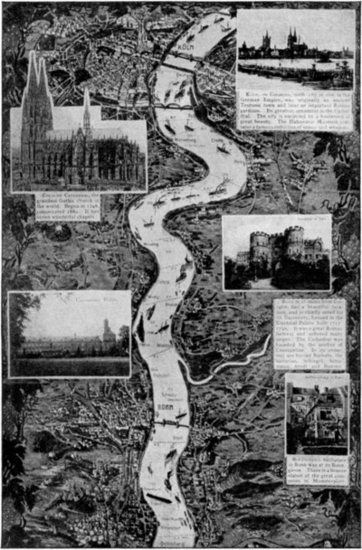
[Top left] Cologne Cathedral, the grandest Gothic church in the world. Begun in 1248, consecrated 1880. It has seven wonderful chapels.
[Bottom left] University Bldgs.
[Top right] Köln, or Cologne, sixth city in size in the German Empire, was originally an ancient Teutonic town and later an important Roman garrison. Its greatest ornament is the Cathedral. The city is encircled by a boulevard of great beauty. The Hahnentor Museum contains a famous collection of armor and weapon.
[Center right] Hahnentor in Cöln
[Center right] Bonn is 21 miles from Cologne, has a beautiful location, and is chiefly noted for its University, housed in the Electoral Palace built 1717-1730. It was a great Roman fortress and suffered many sieges. The Cathedral was founded by the mother of Constantine. In its cemetery are buried Niebuhr, the historian, Schlegel, Schumann, Arndt and Bunsen.
[Bottom right] Beethoven’s birthplace in Bonn was at 20 Bonngasse. There is a bronze statue of the great composer in Münsterplatz.
Large image (567 kB)
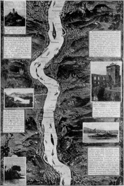
[Top left] Godesburg Castle. A fine mediæval castle on a hill overlooking the Rhine. Splendid view.
[Top left] Rolandseck is half an hour’s sail above Königswinter on the right; and high on the hill above is the fragment of the castle said to have been built by Roland, paladin of Charlemagne, and rich in legends. See Bulwer’s “Pilgrims of the Rhine” for the story, which doubtless suggested Schiller’s ballad of “Ritter Toggenburg.”
[Center left] Rolandseck
[Center left] Remagen is renowned for its beautiful Gothic church on a hill just below the village. It was erected under the direction of Zwirner, the architect of the superb south portal of the Cologne cathedral and is adorned with large frescoes, which are masterpieces of Modern German art.
[Top right] Königswinter is beautifully situated at the foot of the Siebengebirge, or Seven Mountains, and nearest the castles crag of Drachenfels (Dragon’s rock). The Siebengebirge form a picturesque volcanic group, 1,000 to 1,500 ft. high, about 5m. square, covered with forests and ruins. The prospect from Drachenfels and from the Petersberg are among the finest on the Rhine. A funicular railway reaches the top of the Drachenfels and the Petersberg. See story of “Nibelungenlied.”
[Center right] A massive tower and ruined castle at Andernach memorialized in Longfellow’s “Hyperion.” Hammerstein is a 10th century castle where Henry IV. took refuge. It was held during the Thirty Years’ war by Swedes, Spaniards and Germans.
[Bottom right] Andernach, with its ruined castle, ancient walls, and lofty watch tower is one of the most interesting towns on the Rhine. It was one of the 50 forts of Drusus; recaptured from the Alemanni by Julian in 339; a royal Franconian residence in the 6th century; an imperial town later; stormed by Cologne troops in 1496; and burned by the French in 1688. Nearby is the Benedictine Abbey of Laach, founded in 1093, with magnificent Romanesque church, on the vast crater-lake of the Laachser See.
Large image (549 kB)
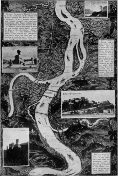
[Top left] Koblenz, the capital of Rhenish Prussia, is at the confluence of the Rhine and Moselle, whence the Romans called it Confluentia. It is a powerful fortress, with heights crossed with enormous fortifications. The Palace contains interesting Electoral Hall and Festival Hall. The Rhine is crossed by a bridge of boats and by a very fine railway bridge. Across the Rhine is Ehrenbreitstein, (“Honor’s Broad Stone”), “The Gibraltar of the Rhine,” a vast fortress on a precipitous rock, 387 ft. above the river, and commanding a wonderful view. It has often been beleaguered but yielded only twice.
[Bottom left] STOLZENFELS.
[Top right] Stolzenfels (“Proud rock”), a fine castle of the middle ages, on a projecting rock overlooking the Rhine, belongs to the Royal Family of Prussia. It was presented by the city of Koblenz to King William IV. Here they say treasures are buried which Archbishop Werner acquired by his knowledge of alchemy. Fine view of the Lahn Valley and Koblenz.
[Center right] Ehrenbreitstein
[Bottom right] Braubach, an ancient little town, at the entrance of the valley that winds round the Marksberg, with a fine old Castle, the Marksburg, a fortress of the middle ages, one of the few ancient Rhine castles which escaped destruction.
Large image (524 kB)
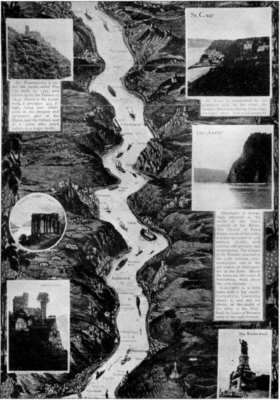
[Top left] St. Goarshausen is under the castle called The Cat, built in 1393, and blown up by the French in 1804. Above is the Lurlei rock, a precipice 433 ft. high, rising over whirlpools in the deepest and narrowest part of the Rhine, and the fabled seat of a siren who lured sailors to a tragic death.
[Bottom left] RHEINSTEIN
[Top right] St. Goar St. Goaris overlooked by the grandest ruin on the river, the famous Rheinfels, dating from 1245; besieged often; now royal property.
[Center right] Die „Lurlei“ Oberwesel is charmingly situated in the midst of the finest scenery of the Rhine. The Church of Notre Dame, south of the town, is a fine specimen of 14th century Gothic, with curious old pictures and monuments. The Chapel of St. Werner, erected in the 13th century, commemorates one of the old stories of child-murder by the Jews. Above the town are the ruins of Schönburg, built about the 12th century. Caub (left) is a little town with a big castle, Gutenfels, towering above it, and not far above, in the midst of the river is the Pfalz, built by Louis of Bavaria early in the 14th century.
[Bottom right] The Niederwald.
Large image (533 kB)
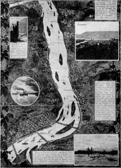
[Top left] Mouse Tower. The Mouse Tower (Mäuserturm) is situated on a rock in the middle of the Rhine, near Bingen. It is notable from the legend of Bishop Hatto’s tragic fate.
[Top right] The Niederwald, opposite Bingen, is the great National Monument commemorating the restoration of the German Empire in 1870-71. It stands 740 feet above the river, and consists of a colossal statue of Germania, 33 feet high, upon a sculptured pedestal 78 feet high.
[Center right] Bingen
[Center right] Bingen is at the junction of the Rhine and the Nahe. The river scenery above Bingen is less interesting, though it is here the fertile and beautiful wine region begins. Rüdesheim, just across the river, has rich wines, far-viewing heights, wild legends, and a Roman fortress. On the heights is the Castle of Johannisberg, where Prince Metternich once lived. It is amid the best vineyards on the Rhine and commands a superb view. At Riebrich, opposite Mainz, is the beautiful palace of the Duke of Nassau.
[Bottom right] Mainz. Mainz, or Mayence, with its magnificent cathedral, has been both a German and a French town. Thorwaldsen’s statue of Gutenberg, the inventor of printing, stands near the Cathedral. The Electoral Palace is a rich museum of Roman relics and an important picture gallery. The city is a noted wine center and trade emporium.
Large image (592 kB)
THE LOWER RHINE FROM COLOGNE TO THE SEA
At Bonn the river enters the plains, and almost immediately after passing the Netherlands frontier its delta begins. The principal arm, carrying two-thirds of the volume, flows under the name of the Waal, and later the Mermede, to Dordrecht, picking up the Maas (Meuse) from the left. At Dordrecht the river again divides for a bit, one branch, the old Maas, running out to sea; the other, the Noord, forming a loop by way of Rotterdam. The northern arm sends one branch, the Yssel, due north to the Zuider Zee; the other branch is the Lek, which runs into the Waal-Maas arm above Rotterdam.
A thin stream, called the “Winding Rhine,” leaves the Lek and splits at Utrecht into two channels, of which the Old Rhine, a mere ditch, manages with the help of a canal and locks to struggle into the North Sea at Katwyk, northwest of Leyden, while the Vecht flows due north from Utrecht to the Zuider Zee near Amsterdam. In the delta the streams have to be bordered by dykes.
THE RHINE IN EARLY EUROPEAN HISTORY
The Rhine was the Romans’ bulwark against the Teutonic invaders and was long a boundary between the province of Gaul and the German tribes. Under Charlemagne the Rhine valley became the focus of civilization. Except between 1697 and 1871 the Rhine was always a purely German river; at the peace of Ryswick, Alsace-Lorraine was appropriated by France, and the Rhine became part of the dividing line between France and Germany. In 1801 Napoleon incorporated the whole of the left bank with France; in 1815 the arrangement in force before 1801 was restored; and after 1871 the Rhine became once more wholly German. It has often been crossed by armies; twice by Julius Cæsar; again in the Thirty Years’ war, and in the wars of Louis XIV., the Revolution, and Napoleon. Its navigation was declared free in 1868.
The Rhine is connected by canals with the rivers Danube, Rhone and Marne. There is a railway along both its banks, but a steamboat is greatly preferable for viewing the incomparable course between Cologne (Köln) and Mainz (Fr., Mayence) as shown in panoramic form on preceding page. Its beauties are better displayed, also, at most points, in ascending the river than in descending it.
THE DANUBE
THE DANUBE (Ger., Donau), one of the most important rivers of Europe, and next to the Volga the largest, originates in two small streams rising in the Schwarzwald, or Black Forest, in Baden, Germany, and uniting at Donaueschingen, two thousand two hundred and sixty-four feet above sea level. The Germans occupy the entire upper basin, and portions of the middle and lower; the Slavs parts of both banks of the middle course; the Magyars the central portion of the valley; and the Roumanians the lower regions.
GENERAL COURSE OF THE GERMAN DANUBE
The river flows first southeast and then northeast to Ulm, one thousand, five hundred and nineteen feet above sea level. At Regensburg it reaches its most northerly point, and from thence its course is generally southeast. Between Regensburg and Vienna the banks of the river are frequently remarkable for their romantic beauty. At Tuttlingen it contracts and the hills crowd close to the banks, while ruins of castles crown almost every possible summit. The scenery is wild and beautiful until the river passes Sigmaringen.
THE AUSTRIAN DANUBE, FAMED IN HISTORY AND SONG
From Passau the Danube flows through Austria for a distance of two hundred and thirty-three miles. Closed in by mountains it flows past Linz in an unbroken stream; below, it expands and divides into many arms until it reaches the famous whirlpool near Grein, where its waters unite and flow on in one channel for forty miles through mountains and narrow passes. Between Linz and Vienna it is renowned not only for its picturesque beauty, but for the numerous historic buildings and ruins which crown its banks. The splendid Benedictine monastery of Melk, the ruins of Durrenstein, and the prison of Richard the Lion-hearted are among the most interesting.
Vienna, to defend the city against risk of inundation, the course of the Danube skirting it was, in 1868-81, diverted into an artificial channel. Similar works have been undertaken near Budapesth, in Hungary.
FROM VIENNA TO THE IRON GATE
After passing Vienna and Marchfeld, the river cuts through a defile formed by the lower spurs of the Alps and Carpathians and enters Hungary at the ruined castle of Theben, a little above Pressburg, the old Magyar capital. Here, again, it gives off a number of branches, forming a labyrinth of islands known as Schütten, but on emerging it flows uninterruptedly southward through wide plains interspersed with pools, marshes, and sandy wastes. The principal affluents here are the Save, the Drave, and the Theiss.
Sixty miles before entering Roumania the river passes through a succession of rapids or cataracts which it has made in cutting a passage for itself through the cross chain of hills which connect the Carpathian Mountains with the Alps. The last of these cataracts, at Old Orsova, is called the Iron Gate. Between 1878 and 1898, the Hungarian government carried through, at a cost of seven million five hundred thousand dollars, extensive engineering works at the gorges of the Iron Gates for deepening the channel and cutting a canal.
ITS JOURNEY THROUGH THE BALKAN COUNTRIES
The lower course of the Danube, in Roumania and Bulgaria, is through a flat and marshy tract, fertile but badly cultivated and thinly peopled. It forms the northern boundary of Bulgaria as far as Silistria; and from here it turns northward, skirting the Dobruja, and flows between marshy banks to Galatz, receiving on the way the Jalomitza and the Sereth. From Galatz it flows east, and, after being joined by the Pruth from the north, it continues southeast to the Black Sea.
The delta is a vast wilderness (one thousand square miles) cut up by channels and lagoons; the farthest mouths are sixty miles apart. Two-thirds of the Danube’s volume passes through the Kilia, which, like the southern or St. George branch, forms a double channel near the outlet; and so ships enter by the middle or Sulina mouth, deepened to twenty feet and straightened in 1858-1903. The steel cantilever bridge across the river at Tchernavoda is one of the great railway bridges of the world.
ITS CHIEF TOWNS AND COMMERCIAL IMPORTANCE
The principal towns on the Danube are Ratisbon, Vienna, Pressburg, Budapest, Belgrade, and Galatz. The width of the river varies considerably, and at some points the opposite shore is hardly discernible. It is first navigable at Ulm, and, thanks to various improvements, is now navigable continuously from that point to its mouth. Engineering work to this end, undertaken at Vienna, Budapest, and the Iron Gates has already been referred to. The International Danube Navigation Commission, appointed in 1856, controls the lower portion of the river, and has done much to improve navigation at the delta. Sea-going vessels of six hundred tons can now go nearly as far as the Iron Gates, while vessels of twenty-five hundred tons can go above Galatz. By means of canals the Danube is connected with the Rhine and the Elbe.
ITS PART IN HISTORY AND INTERNATIONAL POLITICS
This mighty river is exceedingly rich in historical and political associations. For a long period it formed the frontier of the Roman Empire, and along its course are still found many notable Roman remains. Traces of the great wall erected by the Emperor Trajan are to be seen on the south side of the Hungarian Danube. At Turn Severin, east of the Carpathians, a tower and several piers of Trajan’s Roman bridge, a splendid piece of ancient engineering, are still standing; while his more marvelous road in the rocky Kazan defile is marked by a Roman tablet still visible.
The struggles of races and peoples in the lands bordering the Danube have been among the fiercest and strongest in all history. Finns, Kelts, Germans, Slavs, Greeks, Italians and Turks have all vied with one another in the race of conquest and possession; and even today the Balkan countries are still in the seething cauldron of new struggles for domination or independence.
The Lake Region of Europe lies round the Baltic. Ladoga, in Russia, is the largest fresh-water lake in Europe, as wide across as the English Channel, between Portsmouth and Cherbourg. Onega, and Peipus (Russia) are also of great size, as well as the lakes of Finland and Sweden, and some of those of the Alps. Chief of these are Wetter and Mœlar in Sweden; the myriad lakes of Finland; the beautiful lakes of the folds of the Alps, Geneva, Neuchatel, and Constance on the north side; and Maggiore, Como, and Garda in the Italian valleys. They will be noticed further under the countries to which they belong.
THE NATIONS OF EUROPE—THE GREAT POWERS
Of the nations of Europe it may be said that in point of rank Great Britain, Germany, France, Austria, and Russia stand first as the “five great powers.” These include within their limits more than two-thirds of the entire population of Europe, and have for a long time controlled all continental questions. Second come Italy, Spain, and Sweden; in third rank are Turkey, Belgium, Holland, Denmark, and Portugal.
Another grouping on the basis of race stocks is frequently made beginning with the highest in culture, the Germanic; passing thence to the Romanic; concluding with the Slavonic, and the lands under the rule of the Turks, lowest in the scale, which are most closely connected with the Mongols of Asia. The Germanic, or Teutonic nations, include Great Britain; the German Empire; Austria-Hungary; Scandinavia (Norway, Sweden, Denmark); Holland, or the Netherlands; Switzerland, and Belgium. The Romanic nations include France; Italy; Spain; Portugal; Greece, and Roumania. The Slavonic nations, Russia in Europe; Servia, and Montenegro. The Turkish or Mongol nations, Turkey in Europe; Bulgaria.
For various reasons the first grouping is adopted in the pages following.
GREAT BRITAIN
The British Empire, Great Britain and England are often erroneously used in the popular mind for one and the same nation. In strict accuracy the British Empire consists of (1) The United Kingdom of Great Britain and Ireland; (2) India, and the British Colonies, Protectorates, and Dependencies. Great Britain proper includes only England, Scotland and Wales. What is really meant is the geographical group of the British Isles, including England, Scotland, Wales, Ireland and the adjacent islands. For here is the source of power and authority that holds together and controls this greatest of modern empires.
Geographical Features.—The British Isles belong distinctly to the mainland of Europe. If we imagine the sea level between England and Holland to fall sixty feet—the height of an ordinary house—the broad Dogger Bank, midway between England and Denmark, would begin to show its sands, and if a fall of two hundred feet took place one might walk dry shod across to the continent, to Belgium, Holland, or Denmark. From its shallows and banks, its stormy cross seas and frequent fogs, the navigation of the North Sea is dangerous; yet the traffic over it is enormous, for it is surrounded by countries, the inhabitants of which have been famous on the seas from the earliest times.
The great highways of commerce from it are Dover Strait, leading to the English Channel, in the south, and the stormy Pentland Firth, which separates Scotland from the Orkney Islands, in the north. The English Channel, though deeper than the North Sea, is also shallow; the enclosed Irish Sea, between England and Ireland, with St. George’s Channel and the North Channel leading out from it to the ocean, has been scoured deeper in its central lines; but there is a width of about fifty miles of shallow sea, or “soundings,” all round the islands, in the west, where they face the broad Atlantic.
Chief Islands and Divisions.—The main island of Great Britain, roughly triangular in shape, measures about six hundred miles in a straight line from its southwest corner, where the granite walls of Land’s End and the dark serpentine cliffs of the Lizard run out into the Atlantic, to the northern apex, the high red sandstone rocks of Dunnet Head, or its companion Duncansby Head, where John o’Groat’s House stood, on the beach of the Pentland Firth.
The base of the island, forming the north coast of the English Channel, measures only about half this distance, or three hundred and twenty miles; and the eastern side, from the chalk cliffs of the South Foreland, on the Strait of Dover, to the Pentland Firth, is about five hundred and forty miles long. No part of the interior of Great Britain is more distant than three or four days’ walk from the sea on one side or other. In the narrower parts of the north of Scotland, indeed, where the Moray Firth runs into the land, it is an easy day’s journey from the head of this inlet of the North Sea to that of one or other of the opposite sea lochs running in from the Atlantic.
The second island, Ireland, more rounded in general outline, measures three hundred miles from Malin Head, its northernmost point, to Mizen Head, its most southerly extremity, and two hundred miles from Carnsore Point, its southeastern corner nearest England, to Erris Head, its northwestern promontory on the Atlantic.
Smaller Islands.—The most extensive of the many island groups and islets are those which lie off the broken west coast of Scotland, the wild and rugged Outer and Inner Hebrides, of which Lewis, separated by the channel called the Minch, and Skye, Mull, Islay and Arran, in the inner group, are the largest. The Orkney group, separated from the north of Scotland by the turbulent Pentland Firth, consist of no fewer than fifty-nine rocky islets; and the Shetlands, forty miles farther north, comprise upwards of a hundred separate points. The high Isle of Man, in the middle of the Irish Sea; Anglesey, close to the Welsh coast; and now united to it by the famous railway tubes across the Menai Strait; and the Isle of Wight, “the garden of England,” in the English Channel, separated from the mainland by the busy Solent, are the others of importance. The Channel Islands, of which Jersey and Guernsey are the largest, belong politically to Britain, but are physically parts of France.
Surface: Mountains and Lowlands.—In the island of Great Britain the highest portions lie generally to north and west, the lowlands to south and east.
The heather-covered Highlands, which fill the north of Scotland, are divided by the great natural passage of Glen More, which runs in a straight line across the island from northeast to southwest into two chief groups, the northern and central.
The northern group consists of irregularly-distributed and often almost isolated masses, separated, it may be, by deep sea-fiords, and presenting every variety of contour, from that of the round mass of Ben Wyvis to the steep, wall-like sides of Suilvein or the sharp peak of Ben Stack. The Central Highlands or the Grampians, extending from the peninsula of Cantyre northeastward to the precipitous coast of Buchan on the North Sea, are far more massive and continuous.
Ben Nevis, a huge round mass ascending abruptly from the shores of Loch Eil at the mouth of the Great Glen, is the highest mountain of the British Isles.
The Southern Highlands of Scotland are more broken, and separated by river valleys. Mount Merrick, in the southwest, is their highest point; the Lowther Hills form their central group; the Pentlands, Moorfoot, and Lammermoor hills their more detached portions, on the northeast.
With the Cheviot Hills, the boundary range between Scotland and England, begins the long Pennine chain, which reaches due south into the heart of England. Cheviot Hill, in the north, Crossfell, and Whernside, and the Peak of Derby, in the south, mark the summits and direction of the chain. To the west of the Pennine chain rises the compact circular knob of slate mountains of Cumberland, of which Scawfell is the summit of England proper. And corresponding to this mass, near the opposite coast, are the eastern moorlands and wolds of Yorkshire.
Separated from the Pennine heights by the plain of Cheshire (west of England) rise the highlands of Wales, collectively called the Cambrian Mountains.
Across the Bristol Channel we come to the heights of the southwestern peninsula of England, with its three groups of Exmoor, Dartmoor, with its rugged granite tors, and the Cornish Heights. These are the more important mountain groups of Great Britain.
Over all the south and east of England the elevations are comparatively insignificant; broad, undulating, grassy uplands, called the South Downs and the Chiltern Hills, rarely attaining more than eight hundred feet of elevation, follow the chalk formation across Southern England as far as Beachy Head on the Channel and the Foreland Cliffs on the Strait of Dover. The limestone Cotswold Hills between these and the Welsh Highlands rise somewhat higher.
Almost all the lowlands of Great Britain lie to the east and south. Here we find the plain of the “New Forest” in Hampshire and the treeless Salisbury Plain, the broad open Valley of the Thames, the “Eastern Plain” of Essex, Suffolk, and Norfolk, extending with rounded shores towards the North Sea; the low “Fen District” behind the shallow estuary of “The Wash,” from which many tracts have been reclaimed; the long “Plain of York” beyond; the valleys of the Tees and Tweed, the latter including the cultivated “Merse,” the march or border land of Berwickshire; the Scottish “Lowlands” between the Central and Southern Highlands; the “Carse” or alluvial plain of Gowrie, north of the Tay; “Strathmore,” the broad valley which extends between the Grampians and their southern outliers; the plain of Cromarty and the level moors of eastern Caithness farthest north of all. The only extensive lowlands on the western side of the island are the “Vale of Severn,” the “Plain of Cheshire,” between the Pennine chain and the Welsh Highlands, the lowlands round the estuary of the Solway, those of Ayrshire, and the Valley of the Clyde.
Crossing over to Ireland, though we find the lines of elevation running generally in the same direction as those of Great Britain, or from northeast to southwest, as shown in the peninsulas of the southwest coast, the mountains appear rather in detached clusters than in definite ranges, with shapes rather rounded than abrupt, forming a fringe round the coasts. The plateau of Antrim, which forms the precipice of Fair Head, the nearest point to the Scottish coast, contains the remarkable basaltic scenery of the Giants’ Causeway.
Giants’ Causeway.—This extensive and extraordinary assemblage of basaltic columns is in the county of Antrim, between Bengore Head and Port Rush. The name is sometimes given to the whole range of basalt cliffs along the coast, some of which reach the height of four or five hundred feet; but it is more properly restricted to a small portion of it where a platform of closely-ranged basalt columns from fifteen to thirty-six feet in height runs down into the sea in three divisions, known as the Little, the Middle, and the Grand Causeway. The last is from twenty to thirty feet wide, and stretches some nine hundred feet into the sea.
The Giants’ Causeway derives its name from the legend that it was built by giants as a road which was to stretch across the sea to Scotland. There are similar formations on the west coast of Scotland, on the island of Staffa.
In the southwest are the Mountains of Kerry, containing Cam Tual, the summit of all Ireland. The only important groups that lie centrally in the island are the mountains of western Tipperary.
Within the circle of these heights, and branching out between them at many points to the sea-coast, lies the Great Plain of Ireland, averaging perhaps two hundred feet in elevation above the sea. The highest point between Dublin and Galway, east to west across its center, is only three hundred and twenty feet above the sea-level. Many parts of it, such as that which surrounds Lough Neagh in the north, are scarcely fifty feet in elevation.
Rivers.—England and Ireland are very bountifully watered; Scotland rather less so, as the higher mountains of Great Britain rise in the west of the island, so the water-parting line following the greatest general height lies nearer the west than the east. The longer and gentler slope of the island is to the North Sea; the shorter and steeper to the Atlantic side. Hence most of the larger rivers belong to the North Sea drainage.
The Thames (Temz), the most important river of Great Britain, flows southeast by east across the southern portion of the country. It rises in the Cotswold Hills and follows a course of some one hundred and ninety miles to Gravesend, the head of the estuary, where it has a width of half a mile, gradually increasing then to ten miles at the Nore lightship about thirty miles farther. By the addition of its tributaries the Colne, Leach, and Churn, it becomes navigable for barge traffic at Lechlade, where the canal to the Severn leaves. Above Oxford the stream is frequently called the Isis. At Oxford the navigability improves, and river steamers ply between Oxford and points below it as far as London. Until the Tower Bridge, in London, was built, London Bridge was the lowest in the course, and ocean-going vessels still reach the latter.
Gravesend, twenty miles lower, grew up at the spot where vessels waited the turn of the tide; a little farther the Medway, by virtue of its estuary the most important tributary, enters; just inside this is Chatham, an important naval depot. Opposite Gravesend and on the north bank is Tilbury, the terminus of modern liners. The waters from the Tilbury docks to the Nore lightship are of great strategic importance, hence there is here a station for destroyers, torpedo-boats, and gun-boats. Sheerness and Shoreham as land defenses add to this.
From London Bridge downward the Thames is lined with docks and wharves, the former being now under the Port of London authority. At Woolwich, on the south bank, eight miles below London Bridge, is the arsenal, and a little farther up the river Greenwich Observatory.
Historically, the Thames is unsurpassed by any river of the world. A slight rise surrounded by marsh on the left bank formed the first point suitable for bridging a strategic site for London, the tide giving facilities to it as a port, while yet placed well up the river for defensive purposes. Still farther up, a dominating site in the lower valley was found at Windsor for the mediæval kings. In Anglo-Saxon times the kingdoms were divided by the river, and the break in the Chiltern Hills at Goring was a check in the line of aggression.
Above London the scenery is rich and beautiful, though not romantic, the numerous islands lending a peculiar charm. The Thames is the best beloved of English rivers for those who boat for pleasure. During the summer the Thames is a favorite holiday resort, house-boats being frequently the temporary homes of pleasure-seekers; and regattas are held at Henley, Kingston, and other places. For boat-racing, it divides the honors with the Tyne. The Thames watermen are renowned in song and story. Since Spencer’s days “the silver-streaming Thames” has been sung by England’s poets; Herrick calls it “Silver-footed Thamesis;” Denham’s apostrophe is famous; and Pope has word-painted much of the scenery of its banks.
Other British Rivers.—The next longest river to northward is the Great Ouse, navigable from the west for ninety miles to Bedford; then we come to the group of rivers which water the long plain of York, and unite in the estuary of the Humber, including the Trent from the south, navigable one hundred and five miles to Burton; the Yorkshire Ouse, navigable forty-five miles to the city of York, with its main tributary the Derwent. Farther north are the Tees and Wear, and the busy Tyne. Passing into Scotland, we reach the Tweed, valuable for its fisheries, but unnavigable; the Forth, winding in links through the fertile lowland, navigable to Stirling; the Tay, navigable to Perth; the rapid Dee and Spey from the Grampians, and the Ness from the lakes of Glenmore.
On the western or Atlantic side of Britain, the largest river, the second in drainage area in the island, is the Severn, drawing its upper tributaries from the Welsh mountains, and its chief lower affluent, the navigable Avon, from England, curving round to the British Channel; it is navigable to Welshpool, one hundred and twenty miles from its mouth. The Mersey, though a short river, forms one of the most important estuaries of the island, the “Liverpool Channel.” Scarcely less valuable in this respect is the lower Clyde, the most important commercial river of Scotland, navigable to Glasgow, and forming in its upper valley the largest falls in the island.
Almost all the river estuaries of Britain are great highways of commerce; the Solway Firth, between England and Scotland on the west coast, is the most important exception, its swift and strong tides, rushing in over the sands so fast that a galloping horseman can scarcely escape from them, being exceedingly dangerous to shipping. Besides these estuaries many natural harbors lie round the coast. Such are the sheltered Solent and Portsmouth harbor behind the Isle of Wight, Plymouth Sound farther west, and Milford Haven on the south coast of Wales, unsurpassed perhaps in the world as a deep and spacious harbor thoroughly sheltered from all winds.
British Lakes.—The lakes of South Britain are comparatively few and small. Bala Lake, only four miles long, is the largest in the Welsh Highlands; in England the only considerable group is that which clusters round the knot of mountains in Cumberland, known through the rare interest that has been added to this district by the group of illustrious poets who made it their home about the beginning of the nineteenth century.
English Lake District.—Within this area are grouped as many as sixteen lakes or meres, besides innumerable mountain tarns and streams. The district extends about thirty miles from north to south by about twenty-five from east to west, and contains within its compass the utmost variety and wealth of natural scenery, soft and graceful beauty ever alternating closely with grandeur and sublimity.
Windermere, the largest of the lakes (ten and one-half miles by one mile), lies in the southeast corner of the district and is connected with Rydal Water, Grasmere, Elther Water, and Esthwaite. To the west rises the Scawfell range, terminating in the Old Man of Coniston, which rises above Coniston Water, and to the east of the Scawfell range lies Wastwater (three miles long), the deepest of all the lakes. In the northeast is Ullswater, with the sequestered Hawes Water to the southeast. To the west of Helvellyn is Thirlmere, which is the reservoir for the water supply of Manchester, dammed in 1890-1894. The river Derwent, rising in the Scawfell range, flows north through Borrowdale and forms Bassenthwaite and Derwentwater, the most beautiful of the lakes. Westward from Borrowdale opens a valley in which lie Buttermere and Crummock Water, and between these and the Derwent valley is Ennerdale Water. There are several waterfalls, the chief, perhaps, being Lodore, near Derwentwater. Near Derwentwater lies Keswick, the chief town of the district, while Ambleside and Bowness (Windermere) and Hawkshead (Esthwaite) are other places of importance.
Of the lake school of poets, Wordsworth was the acknowledged head and founder, and his home for sixty years was in the Lake District. Southey, Samuel Taylor Coleridge, and De Quincey were the chief of the group, and Shelley, Scott, Carlyle, Mrs. Hemans, Matthew Arnold, Edward Fitzgerald, Tennyson, Gray, and Charles Lamb, although not directly associated with the school, were connected with the district.
Scotch Lakes.—Scotland abounds in lakes in all three Highland districts, and their number increases towards the north. Loch Lomond, twenty-four miles long, in the largest in Britain, Loch Awe, Loch Tay, Loch Rannoch, and Loch Ericht, may be mentioned as the largest of those in the Grampian valleys. Loch Ness, twenty-four miles long and eight hundred feet deep, with Loch Oich and Loch Lochy, fills the deep trench of the Great Glen between the Grampians and the Northern Highlands; Loch Shin, twenty miles long and only one mile broad, and Loch Maree, are the largest of the Northern Highland region. On the western watershed of the Northern Highlands, however, lakes are so thickly sown that hundreds may be counted from a mountain top, and the Outer Hebrides are covered with a perfect network of them.
Irish Rivers and Lakes.—In Ireland, in contrast to Britain, the watersheds are more evenly divided toward all points of the compass; the greatest drainage, however, is westward to the Atlantic. On this side we find the largest river, the Shannon, one hundred and sixty miles long, draining an area second only to that of the Thames in extent, and affording a navigable highway over the central plain almost up to its source. The Erne is another large river of the western drainage of Ireland. Flowing northward we find the Foyle, and the Bann passing through Lough Neagh, and navigable for fifty-five miles. On the eastern watershed the Liffey, from the Wicklow Mountains, is the most important stream; the Barrow, navigable to Athy, seventy miles from its fine estuary of Waterford Harbor, receiving near its mouth the almost equally important Nore and Suir, is the chief river of the southern drainage; the Blackwater, affording twenty-two miles of navigation, and the Lee, flowing to Cork (Queenstown) Harbor, are the other notable rivers of this slope.
The lakes of Ireland, in contrast to those of Britain, belong rather to the plain than to the mountain regions. Lough Neagh, in the basin of the Bann in the north, is the largest of all in the British Islands, one hundred and fifty-four square miles in area, twenty miles in length. The lakes of the Erne, upper and lower, stand next in size; Loughs Corrib and Mask in Connaught, joined by a subterranean channel, are the largest in the west. The Shannon has three large expansions, Loughs Allen, Ree, and Derg. Most famous for their scenery, however, are the much smaller highland Lakes of Killarney, embosomed in the southwestern mountains of Kerry, and considered the finest in Great Britain.
Climate.—Their maritime situation has a favorable effect on the climate of the British Isles, making it milder and more equable than that of continental countries in the same latitude.
Peoples of the British Isles.—During the four centuries in which the Romans held the lowlands of South Britain, many of the native British tribes became Romanized, but the Celtic peoples of the mountain regions of Wales, the Scottish Highlands, and of the west of Ireland, have retained their language and more or less pure blood to the present day. After the fall of the Roman power the invading Anglo-Saxons and Jutes conquered the island, and to their strong Germanic element followed that of the brilliant Normans, or Northmen who had settled in Normandy, and who had there adopted the religion, language, and manners of the French.
Thus the population of these islands is a mixed Celtic, Germanic, and Romanic one, all its elements being more thoroughly amalgamated in the populous lowlands of Britain, the Celtic remaining purer in the highland regions, which are more difficult of access. In Ireland the Teutonic element prevails along the eastern margin; thence towards the western mountains the transition is gradual to the pure Celtic.
Religion.—In religion, rather more than half the population of England claims membership in the Church of England; the most prominent other bodies being the Wesleyan Methodists, the Independents, and Baptists. About a twentieth part of the population is Roman Catholic.
Cities.—The three largest cities in Wales are Cardiff, Rhondda, and Merthyr Tydfil. The capital of England and of the British Empire is London. The cities next in size (in order of population) are Liverpool, Manchester and Salford, Birmingham, Leeds, Sheffield, Bristol, Bradford, Nottingham, and Hull.
The capital of Scotland is Edinburgh. Glasgow is the industrial metropolis, followed by Dundee, and Aberdeen. After these come, in order of population, Paisley, Leith, Greenock, Coatbridge, Kilmarnock, Kirkcaldy, Perth, Hamilton, Motherwell, and Falkirk.
The capital of Ireland is Dublin; the other chief towns are Belfast, Cork, Limerick, and Londonderry.
There are numerous other cities, towns, villages and districts notable for industrial, educational, historical, literary, or other associations.
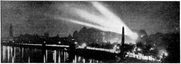
THE VICTORIA EMBANKMENT, LONDON, WITH THE THAMES IN THE FOREGROUND
LONDON, the capital of the British Empire and the second largest city in the world, is situated in the southeast of England on both sides of the River Thames, which winds through it from west to east. The river is crossed by numerous bridges and is deep enough to allow large vessels to come up to London Bridge, the lowest of these (except the movable Tower Bridge), where it is two hundred and sixty-six yards wide. London may be said to stretch from east to west about fourteen miles, from north to south about ten.
The area embraced by the Metropolitan and City police districts, including all parishes within fifteen miles of Charing Cross, is spoken of as Greater London. The population of London roughly equals that of Scotland, Holland, Portugal or Sweden. Under the Act of 1899 London includes the municipal boroughs of Battersea, Bermondsey, Bethnal Green, Camberwell, Chelsea, Deptford, Finsbury, Fulham, Greenwich, Hackney, Hammersmith, Hampstead, Holborn, Islington, Kensington, Lambeth, Lewisham, Paddington, Poplar, St. Marylebone, St. Pancras, Shoreditch, Stoke Newington, Wandsworth, Westminster and Woolwich.
General Features.—The greater portion of London lies on the north side of the Thames, in the counties of Middlesex and Essex, mainly the former, on a site gradually rising from the river, and marked by several inequalities of no great height, except in the northern suburbs, where the elevation of four hundred and thirty feet is reached; on the opposite bank, in the county of Surrey and partly in Kent, the more densely built parts cover an extensive and nearly uniform flat, in some places below the level of the highest tides, while the outskirts are mostly elevated.
The nucleus of London was formed by what is still distinctively the City of London, situated in the heart of the metropolis on the north bank of the Thames. The City is a separate municipality, having a civic corporation of its own, at its head being the Lord-mayor of London. The City occupies only six hundred and seventy-one acres, and has a resident population of only twenty-seven thousand.
Westminster, another portion of old London, associated with the sovereigns, the parliaments, and the supreme courts of justice of England for over eight hundred years, borders with the City on the west; while across the river from the city lies the ancient quarter of Southwark, or “The Borough.” Besides these, London consists of a great number of well-defined quarters or districts, as well as many minor districts, the names of which are familiar to the outside world, such as Whitechapel, Spitalfields, Pimlico, Bloomsbury, Bermondsey, Belgravia, etc. Another loose division of London is into the West End or fashionable quarter, the residence of the wealthy, and the East End, the great seat of trade and manufactures.
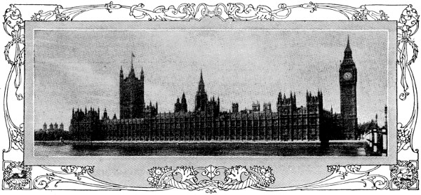
PARLIAMENT BUILDINGS, LONDON
The financial and business houses of the city are principally located to the east of St. Paul’s; the galleries, theaters, and places of amusement between St. Paul’s and St. James’s Park; the parks and residences of the nobility upon the western margin of the city. The railway stations are, with few exceptions, in the suburbs.
London, on the whole, may be called a well-built city, brick being the material generally employed, though many public and other edifices are built of stone. In some streets the brick fronts are made to imitate stone by being coated with cement. The streets are generally well kept and well paved and lighted, but, except in some of the more recent quarters, the general appearance of London is not attractive, much of the effect of the fine buildings being lost by overcrowding and the want of fitting sites.
What generally most strikes a stranger in London is its immense size, which can only be grasped by actually traveling about, or by obtaining a view from some elevation, as Primrose Hill in the northwest, or the dome of St. Paul’s Cathedral near the center, the most conspicuous building in the metropolis. Other striking and also attractive features of London are the parks, especially Hyde Park and Regent’s Park, so valuable as breathing spaces; and the handsome and massive stone embankments along the Thames, forming wide roadways and promenades bordered by trees for long distances.
As the capital of the British Empire, London is from time to time the residence of the sovereign and court. It contains the buildings for the accommodation of parliament and all the great government departments. It is the chief intellectual center of Britain, and is equally great as a center of commerce, banking and finance generally.
Main Streets.—Although in the different districts of London, with the exception of the parts most recently built, there are numerous narrow and crooked streets, yet the whole extent of the metropolis is well united by trunk lines of streets in the principal directions, which render it comparatively easy for a stranger to find his way from one district to another. Picadilly and Pall Mall; the Strand and its continuation Fleet Street, Oxford Street and its continuations, Holborn, Holborn Viaduct, and Cheapside eastward, and Bayswater Road, Notting Hill High Street, and Holland Park Avenue westward, are among noteworthy streets running east and west; while of those running north and south, Regent Street, perhaps the handsomest street in London, and the location of fashionable shops, is the chief. Edgware Road, with its continuations, is an important thoroughfare running northwest. Kings-way and Aldwych, connecting Holborn with the Strand, were opened in 1905.
Many of the streets are closely associated with special trades, industries, pursuits, etc. Thus Bond Street is associated with jewelers, Oxford Street and Regent Street with milliners, the Burlington Arcade with fashionable haberdashers, Fleet Street with newspapers, Northumberland Avenue and the Strand with hotels, Long Acre with carriage builders, Shaftesbury Avenue with theaters, while Pall Mall is the especial center of clubland. Booksellers’ Row and the Lowther Arcade in the Strand, famous respectively for second-hand book shops and for toy shops, have both disappeared quite recently. The Thames Embankment on the north or Middlesex side, known as the Victoria Embankment, also forms a magnificent thoroughfare, adorned by important buildings, and at different points with ornamental grounds and statues.
Bridges.—A number of magnificent bridges cross the Thames. The lowest is the Tower Bridge, a “bascule” bridge opening by machinery so as to let ships pass through. The others most remarkable in upward order (exclusive of railway bridges) are London Bridge, nine hundred feet long, and built of Aberdeen granite; Southwark Bridge, and Blackfriars’ Bridge, all connecting the city with Southwark; Waterloo Bridge, one thousand three hundred and eighty feet long, consisting of nine elliptical arches of Aberdeen granite; Westminster Bridge, an elegant structure of iron, one thousand two hundred feet long, crossing the river from Westminster to Lambeth; Vauxhall Bridge (rebuilding completed in 1906), carrying an electric railway; Putney Bridge, and Hammersmith Bridge. A great traffic passes under the river in tunnels, some for electric railways. The old Thames Tunnel, two miles below London Bridge, now contains a railway. The great Blackwall Tunnel, farther down, is for general traffic.
Parks and Squares.—The chief parks are in the western portion of the metropolis, the largest being Hyde Park and Regent’s Park, which, together with St. James’s Park and the Green Parks, are royal parks. The most fashionable is Hyde Park, containing about four hundred acres. It is surrounded by a carriage-drive two and one-half miles long, has some fine old trees, large stretches of grass, and contains a handsome sheet of water sadly misnamed the Serpentine River. Kensington Gardens (three hundred and sixty acres), with which Hyde Park communicates at several points, are well wooded and finely laid out. St. James’s Park, eighty-three acres, and the Green Park, seventy-one acres in extent, adjoin Hyde Park on the southeast. Regent’s Park, in the northwest of London, north of Hyde Park, containing the gardens of the Zoological Society and those of the Royal Botanic Society, covers an area of four hundred and seventy acres. The Zoological Gardens contain the largest collection of living animals of all kinds in the world. Adjoining Regent’s Park to the north is Primrose Hill. There are, besides, Victoria Park in the northeast of London, Hampstead Heath in the northwest, the happy hunting-ground of the toilers of the city on “bank holidays.” Battersea Park in the southwest, West Ham Park in the extreme east, Greenwich Park at Greenwich, etc.
Of the squares the most central and noteworthy is Trafalgar Square, with Charing Cross adjoining. Most of the squares possess gardens, some public, such as Leicester Square, others private, as Grosvenor Square, Russell Square, Bedford Square, Tavistock Square, etc.
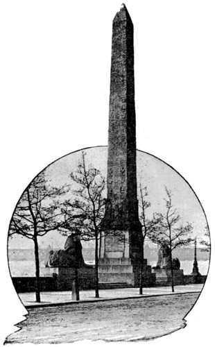
CLEOPATRA’S NEEDLE, LONDON
Monuments.—Among the public monuments are “The Monument” on Fish Street Hill, London Bridge, a fluted Doric column two hundred and two feet high, erected in 1677 in commemoration of the great fire of London; the York Column, in Waterloo Place, one hundred and twenty-four feet high; the Guards’ Memorial (those who fell in Crimea), same place; the Nelson Column, in Trafalgar Square, one hundred and seventy-six and one-half feet high, with four colossal lions by Landseer at its base; the national memorial to Prince Albert in Hyde Park, probably one of the finest monuments in Europe, being a Gothic structure one hundred and seventy-six feet high, with a colossal statue of the prince seated under a lofty canopy; Cleopatra’s Needle on the Thames Embankment; a handsome modern “cross” at Charing Cross; and numerous statues of public men. The Queen Victoria Memorial at Buckingham Palace, on a grand scale, was designed by Sir Aston Webb, R.A.
Public Buildings.—Among the royal palaces are St. James’s, a brick building erected by Henry VIII.; Buckingham Palace, the King’s London residence, built by George IV.; Marlborough House, the residence of the Prince and Princess of Wales; Kensington Palace, a plain brick building, the birthplace of Queen Victoria. These are all in the west of London.
Lambeth Palace, the residence of the Archbishop of Canterbury, is situated on the Surrey side of the river, while Fulham Palace, the residence of the Bishop of London, is in Fulham, near Putney Bridge.
On the north bank of the Thames stand the Houses of Parliament, a magnificent structure in the Tudor Gothic style, with two lofty towers. The buildings cover about eight acres, and cost fifteen million dollars. Westminster Hall, adjacent to the Houses of Parliament, a noble old pile built by William Rufus, was formerly the place in which the Supreme Courts of Justice sat, but is now merely a promenade for members of parliament.
In and near Whitehall in the same quarter are the government offices, comprising the Foreign, Home, Colonial, and India Offices, the new War Office, Horse Guards and Admiralty.
Somerset House, which contains some of the public offices, is in the Strand. The Postoffice in the city occupies spacious and handsome buildings. New Postoffice buildings are on the former site of Christ’s Hospital, the king having laid the foundation stone in 1905.
Adjoining the city on the east is the Tower, the ancient citadel of London, which occupies an area of twelve acres on the banks of the Thames. The most ancient part is the White Tower, erected about 1078 for William the Conqueror.
Other noteworthy buildings are the new Law Courts, a Gothic building at the junction of the Strand and Fleet Street; the Bank of England; the Royal Exchange; the Mansion House, the official residence of the lord-mayor; the Guildhall, the seat of the municipal government of the city; and the four Inns of Court; and Inner and Middle Temple, Lincoln’s Inn; and Gray’s Inn.
Churches.—Among the churches the chief is St. Paul’s Cathedral, completed in 1710 by Sir Christopher Wren. It is situated in the City, occupies the summit of Ludgate Hill, and is a classic building, five hundred and ten feet in length, with a dome four hundred feet in height.
Westminster Abbey, one of the finest specimens of the pointed style in Great Britain, dates from the reign of Henry III. and Edward I. It adjoins the Houses of Parliament, is five hundred and thirty-one feet long, including Henry VII.’s chapel, and two hundred and three feet wide at the transepts. Here the kings and queens of England have been crowned, from Edward the Confessor to George V. In the south transept are the tombs and monuments of great poets from Chaucer downward, whence it is called “Poets’ Corner”; and in other parts are numerous sculptured monuments to sovereigns, statesmen, warriors, philosophers, divines, patriots, and others, many of whom are interred within its walls. Among many old churches are St. Bartholomew’s in West Smithfield; the Chapel Royal, Savoy; St. Andrew’s, Undershaft; St. Giles, Cripplegate; St. Margaret’s, Westminster; St. Stephen’s, Walbrook; the Temple Church, Bow Church, St. Bride’s in Fleet Street. The Roman Catholic Cathedrals at Westminster and in Southwark should also be mentioned.
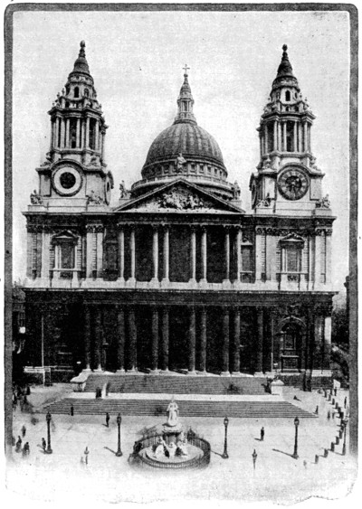
ST. PAUL’S CATHEDRAL, LONDON
Places of Amusement.—These are naturally exceedingly numerous. Among the theaters may be mentioned: Covent Garden, the home of opera; Drury Lane, identified with melodrama and pantomime; His Majesty’s, famous for its efforts in the cause of the higher drama; the Haymarket, St. James’s, Criterion, Wyndham’s New, Duke of York’s, Garrick, Court, and others, for comedy; the Gaiety, Daly’s, Lyric, Prince of Wales’s, Savoy, and Vaudeville for musical comedy and comic opera. The “music-hall” is equally conspicuous among London’s places of amusement, variety entertainments being given at the Alhambra, Empire, Palace, Coliseum, Hippodrome, Lyceum, and a host of others. Among the more dignified concert halls may be mentioned the Royal Albert Hall (capable of holding an audience of eight thousand persons), Queen’s Hall, and Crystal Palace.
Museums.—The British Museum, the great national collection, in a very central position, is the principal one. It contains an immense collection of books, manuscripts, engravings, drawings, sculptures, coins, etc.
The South Kensington Museum is a capacious series of buildings containing valuable collections in science and the fine and decorative arts, and there is a branch museum from it in Bethnal Green, in the East End. The very extensive natural history department of the British Museum occupies a fine Romanesque building at South Kensington. The India and the Patent Museums are also at South Kensington, and here was built the Imperial Institute, partly intended as a museum of home and colonial products, but now also accommodating the University of London.
The Soane Museum contains many valuable objects of art. The chief picture-galleries are the National Gallery, in Trafalgar Square, the National Gallery of British Art (known as the Tate Gallery), the collection in the Victoria and Albert Museum, and the National Portrait Gallery. Mention must also be made of the Wallace Collection, at Hertford House, Manchester Square, a magnificent collection of pictures, sculpture and objects of art, bequeathed to the nation by the widow of Sir Richard Wallace in 1897.
The chief libraries are the British Museum, Lambeth Palace library, the Guildhall library, Sion College library, the London library, London Institution library. Many free libraries have recently been established.
Shipping.—The port of London has been for many years the greatest in the world. The control and management of the business of the port was transferred in March, 1909, from the Thames Conservancy to the Port of London Authority. This new body controls the river from Teddington to Warden Point, fifty-one miles east of London Bridge. It also took over the India, Millwall, and Surrey Commercial docks. The total cost of the transfer was one hundred and twelve million dollars.
Its Cosmopolitan Population.—There are in London nearly 60,000 persons of Scottish birth and over 60,000 of Irish birth. Of 150,000 foreigners, 40,000 are Russians (including Jews), with 16,000 Russian Poles, 30,000 Germans, 12,000 French, 11,000 Italians, 6,000 Austrians, 6,000 Americans (U. S.), 4,500 Dutch, 45,000 Swiss, 2,500 Belgians, 1,800 Swedes, 1,000 Norwegians, and 1,000 Danes.
COMMERCIAL AND INDUSTRIAL CENTERS
In England and Wales.—Hull, the Tyne Ports (Newcastle, Gateshead, and Shields), and Sunderland, with London, form the great outlets of the east of England. Liverpool (with Birkenhead), ranking with London in maritime importance, and Bristol, are the great outlets and seats of commerce in the west of England, as Southhampton and Plymouth on the Channel are in the south.
The most important of all the textile industries of England is that of cotton, which has centered itself in Manchester and in its satellite cities on the coalfield of Lancashire and Cheshire (Preston, Blackburn, Oldham, Wigan, Bury, Rochdale, Bolton, Stockport, Macclesfield), drawing a dense population round these centers, with their thousands of factories, fed with raw material from abroad, and relieved of their manufactured products by Liverpool and the port of Manchester.
The woolen manufactories, next in importance, are on the opposite side of the Pennine chain, in the great towns of Leeds and Bradford, as well as in Halifax, Huddersfield, Wakefield, and Dewsbury, clustering round these. Linen manufactures center at Barnsley, farther south, also on this Yorkshire coalfield. Three outlying woolen manufacturing centers may be noted; these are Leicester, in a famous sheep-raising district, and Kidderminster, noted for its carpets, Stroud, Bradford, and other towns in the west of England, noted for the quality of their cloth. Newtown, in Montgomeryshire, is the center of the Welsh flannel trade.
Hardwares have two great points of production—the one round Sheffield, on the Yorkshire coal and iron field, the other round Birmingham and the towns on the South Stafford coal and iron field (Wolverhampton, Wednesbury, Bilston, Dudley, Walsall), called the “Black Country” because large parts of it are so completely cut up with collieries and ironworks that no cultivation exists.
In North Staffordshire, between the iron and the cotton manufacturing regions, lies the “Potteries,” a district which by supplying coal is able to maintain its staple industry. Stoke-upon-Trent is the center of the cluster of Pottery towns (Burslem, Longton, Hanley, Tunstall), all connected by lines of busy hamlets. Worcester, on the Severn, is also celebrated for its pottery.
English silk manufacturers give importance to three separate districts, those round Congleton and Macclesfield, in Cheshire; Derby; and Coventry, in Warwickshire. Nottingham town combines silk and cotton manufactures in hosiery and lace work. Stafford town supplies boots and shoes to all the manufacturing towns which lie round it.
The coal trade of North England centers in the Tyne Ports and Sunderland, which are also famous for their iron, ships and engines, and their chemical works. The South Wales iron and coal field has its heart in Merthyr Tydfil, one of the largest towns of Wales; Cardiff, with fine docks and iron shipbuilding yards, besides its large coal export trade; Swansea is the headquarters of copper and tin smelting, from ores brought thither from the most distant parts of the world; Milford Haven aspires to becoming the rival of Liverpool in the trade with America.
Among the few large towns besides London which lie outside the manufacturing and mining region of England, may be noted Norwich, in agricultural Norfolk, a seat of manufactures of the most various kind, introduced by about four thousand Flemings who fled thither in Queen Elizabeth’s reign.
In Scotland.—On the Scottish coal and iron field, Glasgow, favored by its position on the estuary of the Clyde, has risen to be at once the great commercial and manufacturing center of the country, carrying on a large trade with all parts of the world, in manufacturing cottons and machinery, and in building ships. A number of manufacturing towns (Paisley, noted for its shawls; Greenock, for its sugar-refining; Dumbarton, for its iron ships; Airdrie, in the midst of the collieries and iron works) have risen round Glasgow over the Scottish coalfield. Leith, the port of Edinburgh, is mainly engaged in the Baltic grain trade; Dundee, on the estuary of the Tay, owes much of its prosperity to its jute and hemp factories, and to its Greenland whaling and sealing trade.
In Ireland.—Owing to its poverty in coal and iron, the manufactures of Ireland have not attained an extent at all comparable with those of Britain. Its only extensive manufacturing district is that which lies round Belfast, in the northeast, where the flax, grown largely in the north of the country, is made into linen. The linen district extends to Armagh, on the west, and Coleraine, in the north.
Dublin, the capital, is noted for its poplins, stout, and whiskey; its quays afford excellent accommodation for shipping, and it takes the lead in the foreign trade of Ireland.
Cork, with its fine harbor the “Cove of Cork,” or Queenstown, in the south; Limerick, on the Shannon; Galway, the port of the west; Londonderry, in the north, are the other important centers of population in Ireland.
EDUCATIONAL, HISTORICAL AND LITERARY CENTERS
Edinburgh (ed-in-bo-ro; Edwin’s burgh), the metropolis of Scotland, grew up originally beneath the protecting walls of its castle, and is not a manufacturing town, but derives its importance mainly from the law courts, its university and schools, and its printing and publishing trade. It is situated upon two ridges of ground, divided by a deep, narrow valley, formerly a morass, now made into a public park, through which the railways pass. To the north of this park is the New Town, composed of modern and elegant buildings—the principal street, Princes Street, bordering upon and overlooking the park. The principal hotels are on the opposite of Princes Street. The railway stations are in the valley. To the south lies the ridge of the Old Town, terminating, to the west in a rocky bluff, upon which stands the Castle in the heart of the city. The Old Town is the historic part of the city, the New being quite modern. The first Scottish Parliament was convened here by Alex. II., 1215.
The principal places of interest are Edinburgh Castle, Holyrood Abbey and Calton Hill. Among the objects of less interest are the house of John Knox, High Street; St. Giles Church; Allan Ramsay’s Theater, the favorite resort of Burns; the Black Turnpike, the prison of Queen Mary, near the Iron Church; and the Heart of Midlothian, the site of an old prison. Annie Laurie was married in Iron Church two hundred and fifty years ago. John Knox is buried in the paved court between the Parliament House and St. Giles; marked by the letters J. K. in the pavement.
The Castle, stands on a precipitous rock about three hundred feet above the valley, accessible only from the east side. It is an extensive mass, of which the oldest portion—and the oldest building in the city—is St. Margaret’s Chapel, the private oratory of the Saxon Princess Margaret, queen of Malcolm Canmore. Another portion is a lofty range of old buildings, in a small apartment of which Queen Mary gave birth to James VI. in 1566; while in an adjoining apartment are kept the ancient regalia of Scotland. Here, also, is the old Parliament Hall, restored in 1888-1889. The castle as a fortress contains accommodation for two thousand soldiers, and the armory space for thirty thousand stand of arms. An old piece of ordnance built of staves of malleable iron, cask fashion, and known as Mons Meg, stands conspicuous in an open area.
Holyrood Palace and Abbey was founded by King David I., who is said to have been saved from the horns of a stag, driven to bay near this spot, by a luminous cross in the sky. In the northwest angle of the building are the apartments which were occupied by Mary, Queen of Scots, nearly in the same state in which they were left by that unfortunate princess.
Calton Hill (call-ton) is at the eastern end of Princes Street and has an altitude of about three hundred and fifty feet. Upon the hill, adjacent to the stairs, is Dugald Stewart’s monument at the left; to the north is the Old Observatory, and the New Observatory with a small dome. To the south is Nelson’s monument, one hundred and two feet high, surmounted by a time-ball. The unfinished colonnade is a part of a structure in honor of Waterloo, intended to be a copy of the Parthenon at Athens. The foundation was laid 1822, but, proving too costly, the project was abandoned.
The view from the summit of this hill is scarcely to be surpassed. To the north is what may be called New Edinburgh, extending toward Granton and the port of Leith. Across the Forth, is Fifeshire. Following down the Forth, is first, the islands of Inch Keith, Portobello, Bass Rock, and the Isle of May, farther at sea. Toward the south and west the Burns monument; Holyrood immediately below; Salisbury Craig and south, Arthur’s Seat, eight hundred and twenty feet high; thence to the north the Old Town, commanded by the frowning Castle.
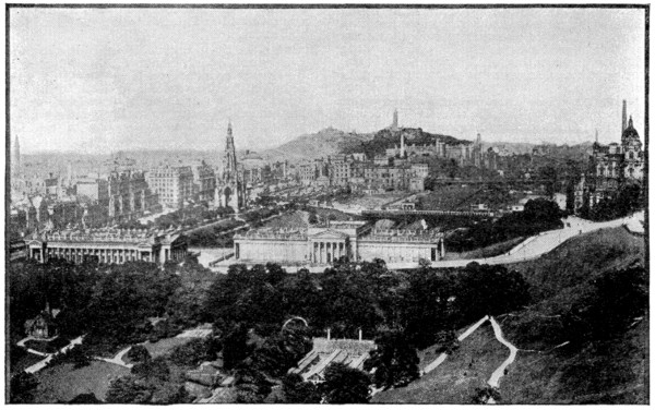
VIEW OF EDINBURGH FROM THE CASTLE
Oxford, capital of Oxford county, and seat of one of the most celebrated universities in the world, is situated about fifty miles northwest of London, on a gentle acclivity between the Cherwell and the Thames, here called the Isis. Oxford, as a city of towers and spires, of fine collegiate buildings, old and new, of gardens, groves, and avenues of trees, is unique in England.
Of the university buildings the most remarkable are Christ’s Church, the largest and grandest of all the colleges, with a fine quadrangle and other buildings, and a noble avenue of trees. It was founded by Wolsey in 1525, and its magnificent chapel is the cathedral church of the see of Oxford. The hall is a noble room.
Merton College, founded about 1264, has a very beautiful chapel of the fifteenth century, and the library is the oldest in the kingdom.
New College, founded by William of Wykeham, in 1386, is one of the wealthiest of the colleges, and the chapel is very handsome.
The gardens of St. John’s College are much admired and the grounds of Magdalen College (perhaps the most beautiful college in Oxford) are no less attractive. The latter include “Addison’s Walk,” a shaded avenue that was his favorite resort when a student here. The Bodleian Library and Picture Gallery, the Theatre (built by Wren), the Ashmolean Museum (also by Wren), the Radcliffe Library and Observatory, the Divinity School (in the hall of which Cranmer, Latimer, and Ridley were tried in 1555), St. Mary’s Church, the Taylor Institute, the University Galleries and Museum, the Botanical Gardens, and the Martyr’s Memorial are also among the noteworthy things in Oxford. The High Street is the subject of one of Wordsworth’s sonnets; and Hawthorne calls it “the noblest old street in England.” Oxford depends mostly on the university, and on its attractions as a place of residence.
Stratford-on-Avon, Shakespeare’s birthplace, is a pleasant town of Warwickshire, eight miles southwest of Warwick, twenty-two miles southeast of Birmingham, and one hundred and ten miles northeast of London. It stands on the right bank of the quiet Avon, which here is spanned by the “great and sumptuous bridge” of fourteen pointed arches, three hundred and seventy-six yards long, that was built by the Lord Mayor of London.
It is a quiet, old-fashioned place, with wide and well-kept streets, and many handsome mansions. The Town Hall was dedicated to the memory of the poet. Here is a statue of Shakespeare, presented by Garrick, on the pedestal of which are the lines from Hamlet; “Take him for all in all, we shall not look upon his like again.” Very interesting is the Shakespeare Memorial Building and Theater, in a charming situation by the Avon, the outgrowth of the feeling that the poet should have a suitable monument in his native town.
Shakespeare’s House, in Henley Street, became national property in 1847, and has been carefully restored. The room in which the poet is said to have been born seems to have undergone but little change since that day. In another room there is a small museum of Shakespearian curiosities.
Stratford Church, in which Shakespeare is buried, is on the bank of the Avon. It is a large and elegant structure, with a graceful stone spire one hundred and sixty-three feet high, erected in 1764 to replace a wooden one that had been taken down. The building has been judiciously restored in recent years. There is an elegant window illustrating Shakespeare’s “Seven Ages,” the contribution of Americans.
The grave of Shakespeare is in the chancel, covered by a plain flagstone, while above, on the wall to the left, is the monumental bust which is the most trustworthy representation of the poet. His wife lies near him, with his favorite daughter, “good Mistris Hall,” and Dr. John Hall, her husband. In the chancel there is also an elegant marble monument to John Combe, the poet’s friend.
Shottery, where Anne Hathaway lived before she became the wife of Shakespeare, is about a mile from Stratford, and may be reached by a footpath through the fields. The cottage that was Anne’s home has a timber and plaster front, and a thatched roof. The interior contains the oaken seat on which Shakespeare and Anne were wont to sit; many bits of venerable furniture; and, upstairs, a vast bed, on which many a Hathaway has drawn the last breath of life.
Stratford also possesses a memorial fountain, presented by George W. Childs of Philadelphia, and Harvard House, the birthplace of the mother of John Harvard, founder of Harvard University. It is still an important agricultural center; but its chief prosperity depends on the thirty thousand or so pilgrims who visit it yearly.
Ayr, forty miles from Glasgow, Scotland, by railway, is noted especially as the birthplace of Burns, the poet; as also the place where Wm. Wallace was imprisoned. The town is divided by the river Ayr, over which are the “twa brigs” of Burns. The Burns Cottage, or birthplace, the scene of his “Cotter’s Saturday Night,” is two miles south of the town, and is now used as a public memorial. It contains few articles associated with Burns.
Alloway Kirk, mentioned in “Tam O’Shanter,” or what remains of it, is one-half mile south of the Cottage. Near the church are the Burns monument, a circular shaft sixty feet in height, erected 1820, and the Doon, immortalized in the “Banks and Braes of Bonny Doon.”
Burns died at Dumfries, where he had lived three years, and was buried in the churchyard there. Nineteen years later, upon the completion of the monument to his memory, his body was exhumed and placed within the Mausoleum at Dumfries.
Melrose, in the county of Roxburgh, thirty-one miles southeast of Edinburgh, is celebrated for the abbey founded by King David in 1136; destroyed by Edward II. in 1322; rebuilt by Bruce in 1326, and partly demolished by the English in 1545. Sir Walter Scott has given it an enduring description in his Lay of the Last Minstrel.
The material of which it is built is a very hard stone, and much of the carving is as perfect as when fresh from the sculptor’s hand. Within its walls are the graves of kings, and nobles and priests of the olden time; among them Alexander II. of Scotland, and more than one of the renowned Earls of Douglas. Before the high altar the heart of King Robert Bruce is said to have been deposited. Sir David Brewster’s grave is in the churchyard.
Dryburgh Abbey, four miles from Melrose, was founded about the same time as Melrose, and, like that, was destroyed in 1322 by Edward II. Robert I. restored it, at least in part; but it was again destroyed in 1544. St. Mary’s aisle, the most beautiful part of the ruins, contains the tomb of Scott, buried here September 26, 1832; also the graves of his wife and his eldest son, and of his son-in-law Lockhart.
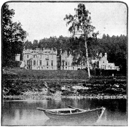
ABBOTSFORD, HOME OF SIR WALTER SCOTT
Abbotsford, two miles from Melrose, was long the home of the “Great Enchanter of the North.” The author’s study is the most interesting room. There the old writing-table, the plain leathern armchair, the reference books, seem to indicate that Sir Walter has but just left them. The Library (twenty thousand volumes) contains a bust of Scott, by Chantrey, and many miniatures. The roof is of carved oak, designed from models taken from Roslin Chapel. The Drawing-room, where Sir Walter died, and the little octagonal dressing-room contain many precious relics. The Armory has a fine collection of Scotch weapons.
Windsor, is in Berkshire, England, on the Thames, twenty-one and one-quarter miles from London. It contains a town hall, built by Sir Christopher Wren in 1686, the church of St. John the Baptist, with fine examples of Grinling Gibbon’s wood-carving, and a fine Jubilee statue of Queen Victoria.
Windsor owes its chief importance to its castle, which stands east of the town on a height overlooking the River Thames, and is the principal royal residence in the kingdom. It was begun, or at least enlarged, by Henry I., and has been altered and added to by almost every sovereign since. The castle stands in the Home Park or “Little Park,” which is four miles in circumference, and this again is connected with the Great Park, which is eighteen miles in circuit, and contains an avenue of trees three miles in length.
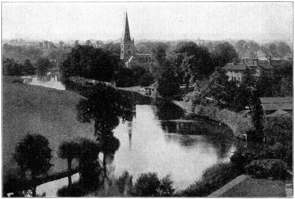
STRATFORD-ON-AVON, IMMORTALIZED BY ITS ASSOCIATIONS WITH SHAKESPEARE
The chief features of interest in the castle are the old state apartments; St. George’s Chapel, where the Knights of the Garter are installed, and the vaults of which contain the remains of Henry VI., Edward IV., Henry VIII., Charles I., George III., George IV., and William IV.; the Round Tower or ancient keep; and the present state apartments.
Eton College is one-half mile from Windsor across the river. The stone chapel, one hundred and seventy-five feet long, is very handsome. There is also a bronze statue of Henry VI. The college was founded in 1440.
Stoke Pogis, the scene of Gray’s Elegy, and the burial-place of the poet, is near Windsor.
There is a fine monument to Gray in Stoke Park.
Cambridge, fifty-six miles from London, and on the Cam, a narrow stream that rambles all over the town. Tradition gives 630 as the date of the foundation of the University; but the oldest college, Peterhouse or St. Peter’s, can only be referred to 1257. The public buildings are the Shire Hall, Town Hall, University halls and library, and Fitzwilliam Museum.
There are seventeen colleges, inferior in architectural beauty to those of Oxford, though their associations are quite as interesting.
Trinity, was founded by Henry VIII. in 1546, and has three fine quadrangles; a splendid hall in the Tudor style; gardens; and an important library, with busts of Newton and Bacon, Thorwaldsen’s statue of Byron, Newton’s telescope and some of John Milton’s manuscripts.
Christ’s College, founded in 1442, was Milton’s college. In the gardens is Milton’s Mulberry-Tree. The quadrangle was rebuilt by Inigo Jones.
Jesus College (1496) and Chapel are very fine buildings, on the site of a Benedictine nunnery.
Caius (pronounced Kees) was founded in 1384, and enlarged in 1557 by Dr. Caius, physician to Queen Mary. Rebuilt lately, it is now one of the best.
Corpus Christi (1351) contains curious portraits, especially those of Sir Thomas More, Wolsey, Erasmus, and Foxe, the author of the Book of Martyrs.
Kings College (1441), founded by Henry VI., is the finest building in the University. The chapel is the finest specimen of perpendicular Gothic existing. The roof, unsupported by pillars, contains twelve divisions of exquisite lace-work tracery in stone. The twenty-four stained-glass windows, each fifty feet high, are beautiful.
The Fitzwilliam Museum, and some of the churches, especially the round chapel of St. Sepulchre, are of considerable interest. All Saints contains a monument, by Chantrey, to Henry Kirke White. Girton College, for women, founded in 1869, is about two miles northwest of the town. The walk along the Cam behind the colleges, with the view of the “Backs” and bridges, is the pride of Cambridge.
ENGLISH HISTORY
The island of Great Britain in the remotest times bore the name of Albion. From a very early period it was visited by Phœnicians, Carthaginians, and Greeks, for the purpose of obtaining tin.
Roman Period.—Cæsar’s two expeditions, 55 and 54 B. C., made it known to the Romans, by whom it was generally called Britannia; but it was not till the time of Claudius, nearly a hundred years after, that the Romans made a serious attempt to convert Britain into a Roman province. Some forty years later, under Agricola, the ablest of the Roman generals in Britain, they had extended the limits of the Provincia Romana as far as the line of the Forth and the Clyde.
Here the Roman armies came into contact with the Caledonians of the interior, described by Tacitus as large-limbed, red-haired men. After defeating the Caledonians, Agricola marched victoriously northward as far as the Moray Firth, establishing stations and camps, remains of which are still to be seen. But the Romans were unable to retain their conquests in the northern part of the island, and were finally forced to abandon their northern wall and forts between the Clyde and the Forth and retire behind their second wall, built in 120 A. D. by Hadrian, between the Solway and the Tyne. Thus the southern part of the island alone remained Roman, and became specially known as Britannia, while the northern portion was distinctly called Caledonia.
The capital of Roman Britain was York (Eboracum). Under the rule of the Romans many flourishing towns arose. Great roads were made, traversing the whole country and helping very much to develop its industries. Christianity was also introduced, and took the place of the Druidism of the native British. Under the tuition of the Romans the useful arts and even many of the refinements of life found their way into the southern part of the island.
Creation of England and Scotland.—From the time of the Roman conquest, and still more decidedly after the Saxon invasions in the fifth century, the history of Britain branches off into a history of the southern part of the island, afterwards known as England, and a history of the northern part of the island, afterwards named Scotland. It was not till the union of the crowns in 1603 that the destinies of England and Scotland began again to unite; and it was not till the final union of the parliaments in 1707 that the histories of the two countries may be said to merge into one.
The Anglo-Saxon Period.—In 411 Honorius abandoned Britain, whose inhabitants, finding it impossible to defend themselves against the Picts, called to their aid the Saxons, who, in 449, assisted them so effectually that they took possession of the country and founded the four kingdoms of Essex, Wessex, Sussex, and Kent. The Angles, who followed them, established three other kingdoms, viz., East Anglia, Deira, and Mercia, 540-584. All these kingdoms ended by being reduced to one, under Egbert, the Saxon king of Wessex, in 827.
After 835 the Danes ravaged England from time to time, but in 871 Alfred the Great forced them to desist, and from thence till near the end of his reign in 900, the Danes left the island in peace. Returning in 981, the Danes succeeded, in 1013, in putting their king, Sweyn, on the throne, which was not recovered by the Saxon dynasty till 1041.
Norman Conquest.—When William of Normandy landed in England to claim the crown which Edward the Confessor had bequeathed to him, he found that the people had raised to the throne Harold, the son of a popular nobleman. The resources of the Saxons, however, had been wasted in domestic conflicts before the attack of William; and the battle of Hastings, in 1066 A. D., gave England with comparative ease to the Normans. The next twenty years saw the conquest completed, and nearly all the large landed estates of the Saxons pass, on every pretext except the true one, into the hands of the Normans. In the course of time the Normans were absorbed among the Saxons, their very language disappearing, though leaving many traces. From this union arose the English people and the English language as they now exist. The union of the Normans with the Saxons was not fully effected so long as the Normans retained their foreign possessions. In King John’s reign the whole of these were lost excepting Guienne and Poitou.