THE BOOK OF NATIONS Geographical, Historical, Descriptive (continued 15)
Reading edition
Within metropolitan Boston are many famous institutions of learning. At the head of these stand Harvard University, Massachusetts Institute of Technology, and Radcliffe College, the greater part of whose schools are in the adjoining city of Cambridge and the remaining in Boston. Among the institutions of higher education are Boston University, with its affiliated colleges, its schools of law, medicine, and theology, and its post-graduate department in philosophy, science, and language; the medical, dental, and agricultural schools of Harvard University; Boston College; the medical and dental schools of Tufts College; Simmons College for Women; the New England Conservatory of Music; the Massachusetts Normal Art School; the Lowell Institute; and the Massachusetts College of Pharmacy.
Wellesley College is situated in the beautiful village of Wellesley, about fifteen miles from Boston, on Lake Waban.
Besides Trinity Church, already referred to, there are upward of three hundred other edifices. Chief of these are the Cathedral of the Holy Cross, on the corner of Washington and Malden Streets, the largest and most noteworthy Catholic church in New England; Arlington Street Church, corner of Arlington and Boylston Streets; First Church of Christ, Scientist, on Falmouth Street, corner of Norway; and Fremont Temple, a Free Baptist Church.
The beauty of the parks, squares, and of many public buildings is enhanced by monuments and statues, of which the following are the chief: Bunker Hill Monument in Charlestown, two hundred and twenty feet high, built of granite and commemorative of the resistance and heroism of American patriots at the Battle of Bunker Hill; the equestrian statue of Washington in the Public Garden; the monument to Colonel Shaw; the Soldiers’ Monument in the Common; the Crispus Attucks monument, a memorial of the Boston Massacre of 1770; statues to General Joseph Warren, Edward Everett, Charles Sumner, Alexander Hamilton, Governor Winthrop, William Lloyd Garrison, Benjamin Franklin, Josiah Quincy, Beethoven, Daniel Webster, Horace Mann, Phillips Brooks and many other notable men.
The principal industries of Boston are the manufacture of food preparations, clothing, building, printing, publishing, and book-binding, distilled liquors, machinery, metals and metallic goods, and furniture. Other important manufactures include musical instruments, woolen goods, boots and shoes, rubber goods, tobacco, and drugs and medicines. As a commercial port, Boston ranks next to New York, the value of foreign trade amounting to two hundred million dollars annually. After London, the city is the leading wool market of the world.
Boston was settled in 1630 by a party of Puritans from Salem. A memorable massacre occurred here in 1770, and in 1773 several cargoes of English tea were thrown overboard in the harbor by citizens. The battle of Bunker Hill was fought on Breed’s Hill, within the present city limits, June 17, 1775. The city charter was granted in 1822.
Cambridge (kām´brĭj), Mass. [So named for the English university town of that name. The English name is supposed to mean “the bridge over the river Cam,” the real name of which is the Granta.]
It is virtually a suburb of Boston, from which it is separated by the Charles River, and with which it is connected by several bridges. The city comprises Old Cambridge, the seat of Harvard University, North Cambridge, East Cambridge, Cambridgeport, and Mount Auburn. The streets are broad and shaded with elms, and there are many places of historical and literary interest, among these the Craigie House and “Elmwood,” the homes of Longfellow and Lowell, respectively; and Mount Auburn Cemetery, containing the graves of Longfellow, Lowell, Prescott, Motley, Agassiz, Holmes, and other noted men.
The chief interest of Cambridge, however, lies in its educational institutions, which include Harvard University, Radcliffe College (for women), Massachusetts Institute of Technology, Episcopal Theological School, and Andover Theological Seminary. All these institutions are now in close working alliance with Harvard University.
Harvard University, founded in 1636, is not only the oldest but the richest of American universities, and the roster of graduates contains more than twenty thousand names. Massachusetts Hall is the oldest of the present buildings, being built in 1720. The most notable buildings architecturally (besides the fine Medical School group in Boston) are: Austin Hall and Longdell Hall, devoted to the Law School; Widener Memorial Library, a splendid new building dominating the college yard; Busch Hall, devoted to the art collections of the Germanic Museum; Memorial Hall, containing Sanders Theater; and Sever Hall, containing class-rooms.
The activities of the university require upward of sixty other buildings, including laboratories, lecture halls, museums, residence halls, and a number of fine structures devoted to the social, religious, athletic and art life of the student body.
The Massachusetts Institute of Technology, founded in 1861, is located on the Charles River Parkway, and occupies a newly acquired area of about seventy acres. Here has been erected a magnificent group of buildings, unrivaled, perhaps, in design, adaptation for their respective uses, and general equipment. This institution is devoted to the teaching of science as applied to the various engineering professions—civil, mechanical, mining, electrical, chemical, and sanitary engineering—as well as to architecture, chemistry, metallurgy, physics, and geology.
Among the industrial establishments are foundries, machine shops, and extensive manufactories. The Riverside, Athenæum, and University Presses are well-known printing establishments, and the “Bay Psalm Book,” the first book printed in America, was published in Cambridge in 1640.
Cambridge was settled in 1630 by Governor Winthrop under the name of Newtowne. In 1636 Harvard College was founded at Newtowne, and in 1638 Newtowne became Cambridge. The Washington elm, under which Washington received command of the American troops, is still standing.
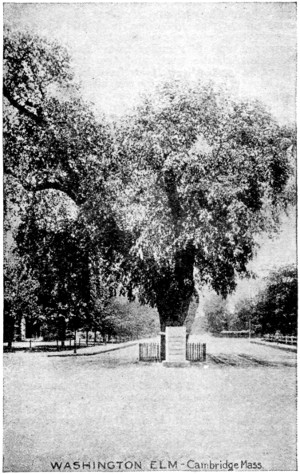
Under this ancient elm near the Cambridge Common, Washington assumed command of the American Continental army July 3, 1775, by order of the Continental Congress. It is therefore one of the landmarks of the greatest historic interest to every liberty-loving American—man, woman, or child.
MICHIGAN BOULEVARD AND GRANT PARK, CHICAGO, VIEWED FROM THE WEST SHORE OF LAKE MICHIGAN
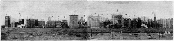
1. Blackstone Hotel 2. Harvester Building 3. Congress Hotel 4. Auditorium Hotel 5. Fine Arts Building 6. Chicago Club 7. McCormick Building 8. Stratford Hotel 9. Railway Exchange 10. Orchestra Hall 11. Pullman Building 12. Gas Building 13. Lake View Building 14. Illinois Athletic Club 15. Monroe Building 16. University Club 17. Ward Building
Left-hand side enlarged (160 kB) Right-hand side enlarged (153 kB)
Chicago (shĭ-kä´gō), Ill. [The “Windy City”], probably received its name from the Indian Checagua, meaning “wild onion” and “pole-cat.”
It is the second city and largest railway center of the United States, and is situated on the southwest shore of Lake Michigan, at the mouths of the rivers Chicago and Calumet, five hundred and ninety feet above sea level and fifteen to seventy-five feet above the lake. It is eight hundred and fifty miles from Baltimore, the nearest Atlantic port, and two thousand four hundred and fifteen miles from San Francisco.
Chicago is noted for the magnitude of its commercial enterprises; for the greatness of its financial institutions; for the excellence of its parks and public playgrounds—particularly in the number, equipment, and splendid use of its small parks in congested localities; for its universities, its efficient public-school system, and for other educational, artistic, and morally uplifting institutions that give to it an enlightened, a cultured, and a progressive citizenship.
It is estimated that not more than 350,000 of the inhabitants are of native American parentage; about 550,000 are Germans, 250,000 are Irish, 225,000 Scandinavians, 160,000 Poles, 110,000 Bohemians, 40,000 Italians, 60,000 Canadians, and 100,000 English and Scottish. There are some fourteen languages, besides English, each of which is spoken by ten thousand or more persons.
The city has a water-front on the lake of twenty-six miles and is divided by the Chicago River and its branches into three portions, known as the North, South, and West Sides, to which must be added the “Loop,” or business part of the city. The site of the city is remarkably level, rising very slightly from the lake; and its streets are usually wide and straight. Among the chief business-thoroughfares are State, Clark, Madison, Randolph, Dearborn, and La Salle Streets, and Wabash Avenue. Perhaps the finest residence streets are Prairie and Michigan Avenues and Drexel and Grand Boulevards, on the South Side, and Lake Shore Drive, on the North Side.
A splendid bird’s-eye view of Chicago is obtained by ascending to the top of the tower of the Auditorium on Congress Street and Michigan Boulevard. This huge building, erected in 1887-1889 at a cost of three million five hundred thousand dollars, includes a large hotel and a handsome theater. The Fine Arts or Studebaker Building, adjoining the Auditorium, on Michigan Boulevard, is one of the show buildings of Chicago, and has deservedly been described as the focus of the artistic and intellectual life of Chicago, containing as it does a theater, concert, assembly, and lecture rooms, studios of leading artists, and the meeting-places of several clubs. The beautiful Romanesque building to the north of the Fine Arts Building is the Chicago Club. A little farther to the north, at the corner of Jackson Boulevard, is the tall Railway Exchange Building, erected in 1903-1904, and cased in tiles. Next to this on the north is the new building of the Chicago Orchestra Association, on the roof of which is the house of the “Cliff Dwellers,” a literary and artistic club. A little to the south of the Auditorium, at the corner of Harrison Street, is the Harvester Building, erected in 1907, beyond which is the palatial Blackstone Hotel. A little farther to the south is the Illinois Central Station.
Following Michigan Avenue toward the north from the Auditorium, we reach the Art Institute of Chicago, an imposing building in a semi-classical style, containing a valuable collection of paintings, sculptures, and other objects of art. Opposite is the magnificent People’s Gas Building, erected at a cost of eight million dollars.
Farther to the north, on the opposite side of Michigan Avenue, are the buildings of the Illinois Athletic Club, the University Club, and the Chicago Athletic Club. At the corner of Madison Street is the Montgomery Ward Building, with its tower, and a little farther up, at the corner of Washington Street, is the Chicago Public Library, an imposing building in a classical style, erected in 1893-1897, at a cost of two million dollars.
This fine edifice is worthy to rank with the Library of Congress and the Boston Public Library. The main entrances are to the north and south, in Randolph Street and Washington Street. The interior is sumptuously adorned with marble, mosaics, frescoes and mottoes. It contains three hundred and fifty thousand volumes. On the first floor is a large Memorial Hall, used by the Grand Army of the Republic and covered by a dome; it contains an interesting collection of Civil War and other historical relics.
On the north, Michigan Avenue ends at the Chicago River. Fort Dearborn stood to the left, on the river, at the end of the avenue.
The business quarters of Chicago occupy chiefly the great central district called the “Loop,” which is bounded by the lines of the Elevated Railway. We may follow Randolph Street to the west to the City Hall and County Building, two large adjoining buildings, in a modern classical style with huge Corinthian columns, built at a cost of five million dollars.
La Salle Street, leading to the south from the County Building, contains some of the finest office buildings in the city. Among these are the Chamber of Commerce at the corner of Washington Street; the Tacoma Building at the corner of Madison Street; the Y. M. C. A. Building, a little farther to the south; the New York Life Insurance Building; the low but impressive Northern Trust Co. Building, and the oddly shaped Women’s Temperance Temple, all three at the corners of Monroe Street; the new granite building of the Corn Exchange National Bank, the Home Insurance Co. Building, and the Rookery, with a very attractive interior lined with white marble. Farther on in La Salle Street, at the corner of Jackson Boulevard, is the Illinois Trust & Savings Bank, a massive two-storied edifice, with a fine central court. At the end of La Salle Street stands the granite building of the Board of Trade.
Jackson Boulevard leads hence to the east to the Federal Building, containing the Post Office and Custom House and occupying an entire city square. It is in the Corinthian style, with a large central dome two hundred feet in height.
Other notable buildings within the “Loop” district include: the Continental and Commercial Bank, Hotel La Salle, First National Bank, and the great department store, office, newspaper, and hotel buildings.
The park system of Chicago is without a parallel in America; it embraces Lincoln Park, on the lake shore to the north, and six others, and is divided into three sections, all connected or nearly so by magnificent boulevards, which, with the park drives, measure over sixty miles. In all, Chicago has ninety-three parks, covering more than four thousand four hundred acres. A characteristic feature of the system is the large number of small “People’s Parks” scattered through the poorer districts and provided with baths, gymnasiums and playgrounds. On the north side is Lincoln Park, reached via Lake Shore Drive, one of the finest residence streets in Chicago, containing some very handsome houses. This passes near the Water Works, at the foot of Chicago Avenue, and ends on the north at Lincoln Park, which is at present three hundred acres in area, but is being extended by filling in the adjacent shallows of Lake Michigan.
Among the attractions of this park are the conservatories, palm-house, lily-ponds, and flower-beds; a small zoological collection; a fountain illuminated at night by electric light; the statues of Lincoln (by Saint-Gaudens), Grant (by Rebisso), Beethoven, Schiller, La Salle, a Mounted Indian, and Linnaeus; and the boating lake. Near the main entrance is the Academy of Sciences, containing admirably arranged and classified collections illustrating the various natural sciences.
Grant Park, consisting of a public pleasure ground of two hundred and ten acres, lies between Michigan Boulevard and Lake Michigan. This park has been improved of late by the depression of the tracks of the Illinois Central Railway and by the construction of massive stone viaducts connecting the park proper with the lake shore. The adjoining part of the lake, between the shore and the breakwater, has been filled in and added to the park. In Grant Park, to the south of the Auditorium and opposite Eldredge Place, is an equestrian statute of General John A. Logan, in bronze, by Saint-Gaudens.
The South Side parks are also fine. They are best reached by Michigan Avenue and Drexel Boulevards, two fine residence streets with tasteful houses and ornamental gardens. Michigan Avenue also contains several churches, the Calumet Club, numerous large hotels and apartment houses, and the First Regiment Armory. In Drexel Boulevard is the handsome Drexel Memorial Fountain.
Washington Park (three hundred and seventy-one acres) and Jackson Park (five hundred and twenty-three acres) are connected by a wide boulevard known as the Midway Plaisance, on which is located the University of Chicago.
The West Side parks, Douglas Park, Garfield Park, and Humboldt Park are little inferior to those of the North and South Sides.
The University of Chicago, between Fifty-sixth and Fifty-ninth Streets, occupies probably the finest group of buildings, architecturally, devoted to higher education in the United States. The total value of buildings and equipment is more than thirty million dollars, one-fourth of which was contributed by citizens of Chicago and the balance by John D. Rockefeller. The ground has an area of sixty-six acres, and the university includes faculties of Arts, Literature, Science, Commerce and Administration, Education, Medicine, Law, and Divinity.
Above thirty different buildings have already been erected, mainly of limestone and in a Gothic style, from the designs of H. I. Cobb and Mr. Coolidge. Perhaps the most successful group is that at the corner of Fifty-seventh Street and Lexington Avenue, including an Assembly Hall, a Students’ Club House, the University Tower, and the University Commons. Other important buildings are the Cobb Lecture Hall, the Kent Chemical Laboratory, the Ryerson Physical Laboratory, the Law School, the Anatomy, Physiology, Zoology, and Botany Buildings, the Walker Museum, the Haskell Oriental Museum, the handsome Bartlett Gymnasium, dormitories for women and dormitories for men. On the south edge of the campus stands the main structure of the Harper Memorial Library, an enormous Gothic building by Shepley, Rutan & Coolidge, erected in memory of President Wm. R. Harper. The Yerkes Observatory, at Williams Bay on Lake Geneva, containing one of the largest refracting telescopes in the world, belongs to the University of Chicago. Connected with the University is the large School of Education, facing the Midway Plaisance, between Monroe and Kimbark Avenues.
Other notable educational institutions include the Lewis Institute, founded and endowed by the late Mr. A. A. Lewis and opened in 1896, comprising a School of Arts and a School of Engineering, tuition in which is furnished at a nominal cost; and the Armour Institute, a well equipped institution for higher technical education, endowed by its founder with three million dollars.
Hull House, at the southwest corner of Polk and South Halsted Streets, is a social settlement of men and women, furnishing a social, intellectual, and charitable center for the surrounding district. It includes a free kindergarten, a coffee-house, a residential boys’ club, a theater, a labor-museum, and a free gymnasium, while classes, lectures, and concerts of various kinds are held.
The famous Union Stockyards (“Packingtown”) are in South Halsted Street, five and one-half miles to the southwest of the City Hall, and may be reached by the South Halsted Street or Racine Avenue trolley-lines, both running directly to the main entrance at Forty-first Street. The yards proper cover an area of about five hundred acres, have twenty-five miles of feeding-troughs, and twenty miles of water-troughs, and can accommodate seventy-five thousand cattle, three hundred thousand hogs, fifty thousand sheep, and five thousand horses. From two-thirds to three-fourths of the cattle and hogs are killed in the yards, and sent out in the form of meat. About thirty thousand workers are employed by the packing-houses. Chicago is the greatest live stock and grain market in the world.
Among the more important general manufactures of the city may be mentioned those of railway cars, locomotives, agricultural implements, mining appliances, clothing, electrical apparatus, lumber products, furniture, pianos, organs, leather, cigars, chemicals, beer, spirits, and flour. The steel and iron industry is conducted on a large scale, and the city has some large rolling mills. Chicago is also one of the leading publishing centers of the United States, and is an active jobbing center for the book trade.
As a center of railroad industry Chicago takes precedence over all cities of the world. Twenty-six of the principal trunk-line railroads of the United States run trains into Chicago terminals, and in addition to these there are numerous belt transfer, terminal and industrial lines which have either a part or all of their trackage in the city. Within the corporate limits of the city are eight hundred miles of main line railway and one thousand four hundred miles of auxiliary track. The total mileage of the twenty-six roads entering Chicago approximates ninety-seven thousand miles, or about forty-two per cent of the total mileage of the United States. The land occupied by main line property within Chicago represents nine thousand six hundred acres, or eight per cent of the entire area of the city.
There are six principal passenger terminals in Chicago, located as follows:
Baltimore & Ohio Terminal (Grand Central Station), at Fifth Avenue and Harrison Street. Central Station, at Michigan Avenue and Twelfth Street. Chicago & North Western Passenger Terminal, at North Clinton, West Madison, and North Canal Streets. La Salle Street Station, with entrance on Van Buren Street. Dearborn Station, at Dearborn and Polk Streets. Union Passenger Station, at Adams and Canal Streets.
Present plans are under way, however, to concentrate all roads entering Chicago in three great union stations—the North Western Station (already built, at a cost of $25,000,000), the Illinois Central Station, and the Pennsylvania Station, the two latter involving an expenditure of one hundred and fifty million dollars.
The water carrying trade of Chicago is comparable to that of New York and Boston, and exceeds that of Philadelphia, New Orleans, Baltimore, and San Francisco.
The Chicago Tunnel System involves a labyrinth of small tunnels or subways, six by seven and one-half feet in size, and sixty-two miles long, forty feet under the principal business streets within the Loop district. These tunnels connect with all railway freight depots, passenger stations and, through their sub-basements, with a number of the larger mercantile concerns. They also extend beyond the Loop—north, south, and west—a distance of about two miles. They are not designed for passenger traffic, but are used by cars laden with all sorts of merchandise, coal, ashes, etc.
There are three underground power stations, four universal freight and transfer stations (one of them occupying five floors below the ground), eighty-five ordinary stations, and twelve tunnels, extending sixty feet under the Chicago River or its branches. So far, between thirty million and forty million dollars have been expended on construction and equipment. The bores also contain the cables of the automatic telephone company.
The site of Chicago was first visited by Joliet and Marquette in 1673. The United States Government established there the frontier post of Fort Dearborn in 1804. On October 8 and 9, 1871, occurred the memorable fire which reduced the greater part of the city to ashes. In 1886 occurred the Haymarket riot, in 1893 the World’s Columbian Exposition was held in Chicago, and in 1894 the Pullman strike, the greatest in history, centered in Chicago.
Cincinnati (sin-si-nä´ti), Ohio. [The “Queen City,” named in honor of Cincinnatus, the Roman patriot.]
It is the second city of Ohio, on the north bank of the river Ohio, two hundred and seventy miles southeast of Chicago by rail, opposite the cities of Covington and Newport, in Kentucky. Steam ferries and six lofty bridges connect the city with the Kentucky shore; the suspension bridge by Roebling is two thousand two hundred and fifty feet long, and cost one million eight hundred thousand dollars.
Cincinnati occupies an exceedingly broken and irregular site, the more densely built parts being enclosed between the Ohio River and steep hills. The river front is upwards of fourteen miles in length. A second terrace is fifty or sixty feet higher, and a district between the hills and the Miami Canal, known as “over the Rhine,” is occupied by the large German colony.
The main portion of the city is regularly laid out and its streets are well paved. The chief shopping district is bounded by Fourth, Main, Seventh, and Elm Streets. The best residential quarters are on the surrounding highlands, built on a succession of irregular hills, by whose steepness they are broken into a series of some five and twenty villages, interspersed with parks.
Fountain Square, an expansion of Fifth Street, may, perhaps, be called the business center of the city and from it start most of the street railway lines. In the middle of the square stands the Tyler Davidson Fountain, cast at the Royal Bronze Foundry at Munich. To the north, at the corner of Fifth Street and Walnut Street, is the United States Government Building containing the Post Office, Custom House, and United States Law Courts, erected at a cost of five million dollars. It is of sawed freestone in the Corinthian style.
By following Fifth Street to the west and turning to the left down Vine Street, we pass the entrance to the Emery Arcade and reach, at the corner of the busy Fourth Street, the Chamber of Commerce. Opposite, at the northeast corner of Fourth and Vine Streets, stands the Ingalls Building. On the north side of Fourth Street, between Vine and Race Streets, is the fine Third National Bank.
Following Fourth Street towards the west, we soon reach Plum Street, which we may follow to the right to St. Paul’s Protestant Cathedral, at the corner of Seventh Street; the Roman Catholic Cathedral of St. Peter, at the corner of Eighth Street, and the Synagogue, opposite the last. In the block bounded by Central Avenue and Eighth, Ninth and Plum Streets is the City Hall, a large red building in a Romanesque style, with a lofty tower, constructed of brown granite and red sandstone at a cost of one million six hundred thousand dollars. A little to the east, in Vine Street, between Sixth and Seventh Streets, is the Public Library. To the north of this point, “over the Rhine,” is Washington Park, with the Springer Music Hall and the Exposition Building.
Among other buildings may be mentioned the County Court House, St. Xavier’s College, the Oddfellows’ Temple and the Cincinnati Hospital. Recent buildings of the modern type include the Traction Building, the Mercantile Library, the Union Trust Building, and the First National Bank.
The chief park of Cincinnati is Eden Park, which lies on the hills to the east and affords fine views of the city and river. It contains the Art Museum, a storage reservoir of the City Water Works, and the Water Tower. The top of the last affords the best view of the city and its environs, the river, and the Kentucky Highlands.
The Art Museum is a handsome group of buildings on a hill-top, some in a Romanesque, others in a Grecian style. Adjacent is the Art Academy. Both are maintained by a private corporation.
There are more than two hundred and fifty churches, including a Roman Catholic cathedral; besides many handsome theaters, hotels, and public halls, hospitals and asylums, and schools.
The educational institutions are of the highest order. They include the University of Cincinnati, which has associated with it the Cincinnati Hospital and the Cincinnati Observatory, the Ohio and Miami Medical Colleges, St. Joseph’s and St. Xavier’s Jesuit Colleges, the Law Theological Seminary, Cincinnati Conservatory of Music and the Ohio Mechanics’ Institute.
Cincinnati is a center of musical and art culture, and its decorative pottery and wood-carving have a national reputation. It has a large river and canal traffic, and many railways converge here.
Among the factories are clothing factories, foundries, machine shops, coach-works, works for the manufacture of furniture, tobacco, shoes, leather, etc. There is some boat-building and printing; and the slaughter-houses, stockyards, and grain elevators are very extensive.
Cincinnati was settled by white men in 1780, was incorporated as a city in 1819, and early attained the name of “the Queen City of the West;” as also that of “Porkopolis,” from its great trade in pork. Great riots occurred in 1884, and were with difficulty suppressed by the military.
Cleveland, Ohio. [The “Forest City;” named in honor of General Moses Cleveland of Connecticut, who had charge of the surveying of this region, acting as general agent for the Connecticut Land Company.]
It is the largest city of Ohio, and is situated on the south shore of Lake Erie, three hundred and fifty miles by rail east of Chicago. The city is built mainly upon a plain from sixty to one hundred and fifty feet above the lake, and five hundred and eighty feet above sea-level. It is divided into the East and West Sides by the tortuous valley of the Cuyahoga River, which is crossed by two high-level bridges—one mainly of stone, and one of iron, three thousand nine hundred and thirty-one feet long. The former, one thousand and seventy feet long, was completed in 1878 at a cost of two million two hundred thousand dollars. There are three other similar viaducts in different parts of the city.
The chief business street is Superior Avenue, a really fine and wide thoroughfare, the west end of which is lined with substantial business blocks, such as the Perry-Payne Building. A little farther on the street expands into Monumental Park or the Public Square, containing a Soldiers’ Monument and a statue of General Moses Cleveland. The new Federal Building, at the northeast corner of the square, contains the Post Office, the Custom House, and the Court House.
This building is the first of several public buildings comprised in the so-called “Group Plan,” the others being the City Hall, County Building, Public Library, and Union Station. A broad mall connects all these buildings.
At the northwest corner is the Old Court House, adjoined by the American Trust Building. On the north side of the square, at the corner of Ontario Street, is the handsome building of the Society for Savings, established in 1849, and now having deposits of upwards of fifty million dollars. Adjacent is the Chamber of Commerce, containing a handsome auditorium, with a library and reading room. In Superior Avenue, beyond the Federal Building, is the massive City Hall, which is adjoined by the temporary building of the Public Library. A little to the north of this point is the huge Central Armory.
Euclid Avenue, which begins at the southeast angle of the Public Square, is, at its east end, also an important artery of business, and farther out becomes one of the most beautiful residence streets in America, with each of its handsome houses surrounded by pleasant grounds and shady trees. At the northeast corner of the Square and Euclid Avenue is the Williamson Building; a little farther on, also on the north side of the Avenue, is the handsome First National Bank; on the right is the tall, narrow building of the Guardian Savings & Trust Co. To the left is the Arcade, four hundred feet long, one hundred and eighty feet wide, and one hundred and forty-four feet high, with a fine five-balconied interior, running through to Superior Avenue; and to the right is the Colonial Arcade, running through to Prospect Avenue. At the corner of East Sixth Street are the tall Garfield and New England Buildings. Nearly opposite the New England Building is the new Taylor Arcade, just east of which is the Hippodrome Building. Farther on, near east Ninth Street, is the Citizens Building, with the offices of the Citizens Savings & Trust Co., and at the corner is the Schofield Building. Directly opposite the latter, at the southeast corner of East Ninth Street and Euclid Avenue, is the Cleveland Trust Co. At the corner of East Twelfth Street is the handsome Union Club. Farther on are several fine churches. About four and one-half miles from the Public Square Euclid Avenue reaches University Circle, with a statue of Senator M. A. Hanna by Saint-Gaudens, and one of Kossuth, erected by the Hungarians of Cleveland. To the right is the building of the Western Reserve Historical Society, to the left is the Elysium, an artificial ice skating rink. Just beyond the Circle is the entrance to Wade Park, which contains statues of Commodore Perry, and a Goethe-Schiller Monument. Opposite the Park are the buildings of the Western Reserve University (including Adelbert College, Woman’s College, Law, Medical, and Dental Schools, and a Library School, in addition to the graduate department) and the Case School of Applied Science. About one mile farther on the avenue passes Lake View Cemetery, containing the Garfield Memorial, the Rockefeller Monolith, the graves of Senator Hanna and John Hay, and the Wade Memorial Chapel.
Prospect Avenue, which runs parallel to Euclid Avenue on the south, is little inferior to it in beauty.
Cleveland’s rapid growth is due mainly to the fact that nowhere else can the rich iron ores of Lake Superior, the coal of Northern Ohio, and the limestone of the Lake Erie islands, be brought together so cheaply; its position at the north terminus of the Ohio Canal being very advantageous, and seven railways terminate here.
The chief industries of the city are the various manufactures of iron, including steel rails, forgings, wire, bridges, steel and iron ships, engines, boilers, nails, screws, sewing machines, agricultural implements and machinery of all kinds, the refining of petroleum, wood-work, and other manufactures of endless variety. Cleveland is the greatest iron ore receiving point in America, one of the largest lumber markets and extensively engaged in the automobile industry.
Cleveland was founded in 1796 by General Moses Cleveland, under the direction of the Connecticut Land Company. In 1814 Cleveland was incorporated as a village with less than one hundred inhabitants. The opening of the Ohio land served as an impetus to growth, and in 1836 Cleveland was incorporated as a city. Its great prosperity dates from its connection by rail with the cities of the East and the manufacturing establishments set up during the Civil War.
Des Moines (dē-moin´), Iowa. [This name was applied by the Indians to a place in the form of Moingona, which the French shortened into Moin, calling the river “rivière des Moins.” Finally, the name became associated with the Trappist monks, and the river by a spurious etymology was called “la rivière des moines,” “the river of the monks.”]
The capital and largest city of Iowa, it is an important manufacturing and commercial city, and noted especially for its extensive insurance interests and exceptional railroad facilities. It has many important buildings, among them the Capitol, built at a cost of three million dollars, the United States Government Building, the State Arsenal, a State Historical Building, completed in 1908 at a cost of five hundred thousand dollars, Drake University, Highland Park College, Des Moines College, and a state library. A new city hall at a cost of four hundred thousand dollars, and a great coliseum to seat ten thousand are recent additions.
The city has nearly one hundred churches of all denominations. Half a dozen bridges over the two rivers connect the different parts of the town, and there is a public park, with fine groves of forest trees.
Vast bituminous coal fields have contributed to the growth of the manufacturing industries. These include typewriters, wagons, sleighs, cotton and woolen goods, pottery, furniture, and electrical appliances. The city was one of the first to adopt the electric car system.
Des Moines was settled in 1846, incorporated as the town of Fort Des Moines, 1851, chartered as a city and became the capital of the State in 1857. In 1907 Des Moines adopted the commission form of government and attained wide celebrity as a leader in progressive municipal government.
Denver, Colo. [The “Queen City of the Plains”; named after James W. Denver, ex-Governor of Kansas, upon the consolidation in 1860 of the towns of St. Charles and Aurora.]
The capital of Colorado, it is situated on the South Platte River, nine hundred and twenty-two miles west of St. Louis. It lies on a level plain, five thousand one hundred and ninety-six feet above the sea, beyond which rise the snow-capped peaks and deep blue shoulders of the Rocky Mountains.
The Union Depot lies at the foot of Seventeenth Street, one of the chief business thoroughfares, and electric cars start from here for all parts of the city. Near the station is a large bronze Arch, bearing the work “Welcome.” The route up Seventeenth Street and Seventeenth Avenue by electric car to the City Park and then across to Colfax (or Fifteenth) Avenue and return traverses the chief features of the city. On the way out is passed the Equitable Building, the roof of which affords a superb view.
The Rocky Mountains are seen to the west in an unbroken line of about one hundred and seventy miles, extending from beyond Long’s Peak on the north to Pike’s Peak on the south. Among the loftiest of the intervening summits are Grey’s Peak, Torrey’s Peak, and Mount Evans. The bird’s-eye view of the city in the immediate foreground includes the State Capitol and the fine residences of Capitol Hill on the east.
At the corner of Seventeenth and Glenarm Streets is the Denver Club, and at the corner of Sherman Avenue are the University Club and the Central Presbyterian Church. In returning through Colfax (or Fifteenth) Avenue the following buildings may be observed: the State Capitol, an imposing structure erected at a cost of two million five hundred thousand dollars; the new Public Library, between Acoma and Bannock Streets; the United States Mint, at the corner of Cherokee street, and the West Side Court House. The County Court House occupies the block bounded by Court Place and Fifteenth, Sixteenth and Tremont Streets. The Custom House and Post Office, on Sixteenth Street, is another imposing building. In Fourteenth Street is a handsome Auditorium used by the Democratic Convention in 1908.
The other important buildings of the city include the Denver High School, Stout Street, between Nineteenth and Twentieth Streets; the City Hall, corner Fourteenth and Larimer Streets; the Mining Exchange; the Chamber of Commerce; Baptist College (Montclair); the Tabor Opera House Block; the Broadway Theater; the Denver Athletic Club; Trinity Church, Broadway and Eighteenth Street; the Church of Christ, Scientist, Fourteenth and Logan Avenues; the Y. M. C. A., Lincoln and Sixteenth Avenues; Mystic Shrine Temple, Sherman and Eighteenth Avenues; the Westminster University of Colorado, and the Jesuit College of the Sacred Heart (College Avenue, corner of Homer Avenue). On Capitol Hill are the new buildings of St. Mary’s Cathedral (Roman Catholic) and St. John’s Cathedral (Episcopalian). The Art Museum, in Montclair, contains a collection of paintings and other objects of art. The Museum in the City Park includes an interesting collection of Colorado animals. In University Park, eight miles to the southeast of the Union Depot, is the University of Denver.
The city is the center of a great agricultural and mining district, and has a large trade in cattle, hides, wool, and tallow. It is chiefly, however, to its position as the center of a great mining region that Denver owes its marvelous progress; the discovery, in 1878, of the fabulous wealth of the Leadville Hills attracted capital and emigration from all parts of the continent. It has a United States assaying mint, is an important ore market, and is noted for its smelting and refining works, foundry and machine shops.
Denver has an abundant water supply, and the clear invigorating air and dry climate of Denver are famous. It was founded on a barren waste, dry and treeless, in 1858, and the following year incorporated as a city by the Provisional Legislature.
Detroit (dē-troit´), Mich. [The “City of the Straits”; named from the river or strait on which the city is built. Derived from two French words, detroit, “the narrows.”]
It is situated on the Detroit River, eighteen miles from Lake Erie, at an altitude of six hundred feet. The river, sometimes called the “Dardanelles of the New World,” is here the boundary between the United States and Canada. It affords a splendid harbor, with a water-front of about nine miles. Ferries connect with the Canadian side. Many beautiful islands, with those of Lake St. Clair, are popular as places of summer residence and resort.
One of these, Belle Isle, is about seven hundred acres in extent and forms a beautiful public park, with fine trees, and still retaining many of its natural features unimpaired. It contains a statute of Schiller, a small zoological collection, a large aquarium and horticultural building, and a casino.
Woodward Avenue, the principal thoroughfare, divides the city into two very nearly equal parts. It is also the main business street, and at its northern end has many of the city’s most prominent buildings. Its expansion, about half a mile from the river, is known as the Campus Martius, adorned with a handsome fountain, from which Michigan and Gratiot Avenues diverge to the left and right. To the left stands the City Hall, the tower of which contains a clock with a dial eight and one-half feet in diameter. In front of the City Hall is the Soldiers’ Monument.
In Gratiot Avenue, near the Campus Martius, is the Public Library, containing two hundred and twenty thousand volumes and some historical relics. The Chamber of Commerce, at the corner of Griswold and State Streets, is thirteen stories high. The Post Office, in Fort Street, adjoining the site of the old Fort Lernoult, is a handsome building. In the same street, at the southeast corner of Shelby Street, is the State Savings Bank, and adjoining it on the east is the tall Penobscot Building.
Just to the east of the Campus Martius, in Cadillac Square, stands the County Building. It is in a plain renaissance style with a Corinthian portico over the main entrance, sculptures in the pediment, and a tower surmounted by a gilded dome. In front of it is the Cadillac Chair, erected in 1901 to commemorate the two hundredth anniversary of the city’s foundation.
A little farther on Woodward Avenue reaches Grand Circus Park, a square with trees, fountains, and a statue of ex-Governor Pingree. To the north, at the corner of Adams Street, is the Central Methodist Church, with a richly decorated interior. One block to the east, between Adams and Elizabeth Streets, is the new building of the Y. M. C. A. At the corner of Edmund Place, one-half mile farther on, are the First Unitarian and First Presbyterian churches, two fine Romanesque buildings of red stone. Between Erskine and Eliot Streets, to the right, is the Temple Bethel, an effective Jewish synagogue. Also to the right, at the head of Martin Place, is the handsome Harper Hospital; and Grace Hospital is also seen to the right (corner of Willis Avenue and John R. Street) a little farther on. To the left, a little higher up, is the Detroit Athletic Club. The north end of Woodward Avenue and the adjoining streets form the principal residence quarter.
Jefferson Avenue, which runs at right angles to Woodward Avenue, crossing it one-fifth mile from the river, contains many of the chief wholesale houses, and toward its northeast end has also many pleasant residences. The site of Fort Pontchartrain was at the corner of Jefferson Avenue and Griswold Street, two squares to the west of Woodward Avenue. To the east, on the left side of the street, are the Roman Catholic Cathedral of Saints Peter and Paul and the Jesuit College, and on the right side the Academy of the Sacred Heart. On the same side, at the corner of Jefferson Avenue and Hastings Street, about one-half mile to the east of Woodward Avenue, stands the Museum of Art, containing paintings, sculptures and oriental curiosities.
The commerce of Detroit is enormous, a number of conditions favoring it as a commercial and industrial center. Its geographical position brings it into relation with an immense lake traffic and with the Canadian trade. About three-fourths of the total trade is with Canada. The principal exports are grain, wool, pork, lard, hides, and copper. It has important lumbering interests and large tanneries.
The manufactures include stoves, freight cars, drugs, varnish, paint, furniture, carriages, cigars, and matches. Other industries are those of iron and steel, foundry and machine shop products, and the manufacture of malt liquors.
The site of Detroit was visited by a party of Frenchmen as early as 1610, and again by La Salle in 1670, but no permanent settlement was made until 1701, when Sieur de la Mothe Cadillac, the first Governor of the French territory in this vicinity, built Fort Pontchartrain and established a small trading village. In 1815 Detroit was incorporated as a village, and in 1824 was chartered as a city by the Legislature of Michigan Territory. It was the capital of the Territory from 1805 to 1837, and of the State from 1837 to 1847.
Hartford, Conn. [Named from Hertford, England.] It is the capital of Connecticut, on the right bank of the Connecticut River, fifty miles from its mouth, and one hundred and twelve by rail northeast of New York. It is a handsome city, finely situated on the navigable Connecticut River, at its confluence with the Park River. The Union Depot is near the center of the town. To the southwest of it, beyond the Park River, lies Bushnell Park, containing the handsome white marble Capitol, a conspicuous object in most views of the town.
The fine sculptural embellishment of the north facade of the Capitol was done under the supervision of Paul W. Bartlett and partly by his own hand. The Senate Chamber contains a good portrait of Washington, by Stuart, and an elaborately carved chair, made from the wood of the “Charter Oak.” In the Library are the Charter of Connecticut and portraits of Connecticut governors. In the east wing of the ground floor is a statue of Nathan Hale, and in the west wing are the tombstone of General Putnam and a statue of Governor Buckingham.
The gateway to the park was erected as a Soldiers’ Memorial.
Following Capitol Avenue to the east and then turning to the left, along Main Street, is the Wadsworth Athenæum, containing a gallery and libraries with one hundred and fifty thousand volumes, and the collections of the Historical Society. Adjacent are the buildings of the Ætna Life Insurance, the Ætna Fire Insurance, and the Travelers Insurance Co. A little farther on is the Post Office, adjoined by the interesting Old State House, erected by Chas. Bulfinch. Opposite is the Connecticut Mutual Life Insurance Co. The State Arsenal is also on Main Street farther along.
Near the State House are the High School, the Hartford Orphan Asylum, and the Hartford Theological Institute. About a mile to the south is Trinity College, with fine buildings and equally fine location. The Colt Firearms factory is in the southeast part of the city, and near it is the handsome Church of the Good Shepherd, erected in memory of Colonel Colt, inventor of the revolver, by his wife.
A tablet at the corner of Charter Oak Place marks the site of the “Charter Oak,” where, in 1687, the charter of Connecticut was concealed to save it from Sir Edmund Andros, a tyrannical British governor. Charter Oak Park is famous for its trotting races. Elizabeth Park has a fine show of flowers.
Among other large buildings are the Retreat for the Insane, the Deaf and Dumb Asylum, the Old Folks Home, the City Hospital, and St. Joseph’s Roman Catholic Cathedral. The last is in Farmington Avenue, which, with its continuation, Asylum Street, contains many fine private residences.
Hartford is a prominent commercial and manufacturing city, and is particularly noted for the importance of its insurance companies, rating third in this regard among the cities of the United States. It is the farthest point, at present, to which large steamers can ascend the Connecticut River. Among the manufactures are firearms—the celebrated Colt manufactory is here—typewriters, rubber goods, especially tires, electrical supplies, automobiles, bicycles, sewing-machines, hardware, tools, carriages, silver plate, woven wire mattresses, book binding machinery, cash registers, knit goods, etc.
The site of a Dutch fort in 1633, and of a colony of Massachusetts settlers as early as 1635-1636, Hartford was incorporated as a city in 1784. Here (January 14, 1639) was adopted the first constitution in writing ever proclaimed by a people organizing a government, therefore Hartford is called the birthplace of American democracy. In 1687 occurred the famous attempt of Governor Andros to seize the charter of Connecticut. Hartford was the capital of Connecticut until 1701, thenceforth until 1873 it divided the responsibility with New Haven. Since 1875 it has been sole capital. Here in 1814 took place the famous meeting of New England delegates known as the Hartford Convention.
About 1780 the “Hartford wits,” of whom Joel Barlow was one, made the city a literary center. Since that time it has been the residence of a large number of literary men and women; among them Harriet Beecher Stowe, Whittier, Trumbull, Charles Dudley Warner, and Samuel L. Clemens. Noah Webster, Henry Barnard, Frederick Law Olmsted, and John Fiske were born here.
Indianapolis (in-di-a-nap´o-lis), Ind. [Literally, the City of Indiana, from Indiana and polis, city.]
It is the capital of Indiana, on the west fork of White River, in a level plain one hundred and ninety-five miles southeast of Chicago by rail. It is a regularly built and beautiful city.
The focus of the city is the circular Monument Place, from which four wide avenues run diagonally to the four corners of the city. The other streets, many of them one hundred feet wide, are laid out at right angles to each other. In the center of this place rises the Soldiers and Sailors’ Monument, two hundred and eighty-five feet high, by Bruno Schmitz of Berlin. Round the monument are statues of General G. R. Clark, Governor Whitcomb, President W. H. Harrison, and Governor Morton. A little to the west is the State Capitol, a large building with a central tower and dome, erected at a cost of two million dollars. At the east entrance to the Capitol is a statue of Governor Morton and near by is that of Governor Hendricks. The Marion County Court House, also an imposing edifice, lies to the east of Monument Place, while to the north of it is the United States Court House and Post Office, erected in 1902-1904. To the southwest of the former is a statue of General H. W. Lawton, by A. O’Connor. In University Park is a statue of Benjamin Harrison, erected in 1908.
The John Herron Art Institute, at the corner of Pennsylvania Avenue and Sixteenth Street, contains a School of Art and a collection of modern paintings. Other large and important buildings are the Blind Asylum; the Propylæum, owned and controlled by a stock company of women for literary purposes; the Deaf and Dumb Asylum; the Union Railway Station; the City Hall; the Public Library; the Masonic Temple; the Oddfellows Building; the Deutsche Haus, a German club-house; the Mænnerchor Building, and several churches. The Winona Technical Institute is installed in buildings erected for the United States Arsenal. The Central Hospital for the Insane lies one and one-half miles to the west of the city, beyond the White River. The Riverside, Broad Ripple, Brookside, Fairview, and Garfield Parks deserve mention.
Indianapolis is one of the chief railroad centers of the United States, fifteen main lines converging here. It is also a great center of electric railways, which radiate hence in all directions, two hundred and fifty cars leaving the terminal station daily. The trade in agricultural produce is very considerable. Pork-packing is the leading industry, but there are also large flour and cotton and woolen mills, numerous foundries, and manufactories of furniture, carriages, tiles, etc.
Indianapolis was first settled in 1819, the city founded in 1821, became the seat of the state government in 1825, was incorporated as a town in 1836, and received its city charter in 1847. In the same year the first railroad in the state was opened.
Los Angeles (los an´je-les, Sp. pron. lōs äng´he-lās), Cal. [Named by the Spaniards Pueblo de la Reina de los Angeles, “The Town of the Queen of the Angels,” hence Los Angeles, “the angels.”]
It is the metropolis of southern California, lies on the Los Angeles River, twenty miles above its mouth and fifteen miles in a direct line from the Pacific Ocean, and four hundred and eighty-three miles southeast of San Francisco by the Southern Pacific Railroad.
It is a splendid city of wide streets and spacious sidewalks, with an extensive residential quarter, one hundred and thirty churches, over sixty public schools, and about one thousand seven hundred manufactories. It publishes newspapers in seven languages.
The city, especially the residential quarters, is embowered in plants, among the characteristic features of which are the swift-growing eucalyptus, the graceful pepper-tree, many palms, Norfolk Island pines, live-oaks, india-rubber trees, orange trees, roses, geraniums, yuccas, century plants, bananas, calla lilies, and pomegranates. A distinguished French traveler pronounces Los Angeles one of the few really beautiful cities in the United States.
Broadway, running parallel to Main Street, is the dividing line for east and west, as First Street is for north and south. Among the many substantial buildings in Main Street are the City Hall, between Second and Third Streets, and the new Chamber of Commerce. The latter contains an interesting collection of California products, the Palmer collection of Indian antiquities, and the Coronel collection, illustrating the Spanish period. Here is also the first cannon brought to California by Padre Junipero Serra in 1769. In Temple Street, near Broadway, stands the County Court House. The Public Library is at the southeast corner of Broadway and Third Street.
Other edifices worthy of mention are the Women’s Club, in the Mission-Renaissance style (940 South Figueroa Street), the State Normal School (corner Grand Avenue and Fifth Street), the Security Savings Bank (corner Spring and Fifth Streets), the Union Trust and Hellman Buildings (opposite corners of Spring and Fourth Streets), the Auditorium (corner Fifth and Olive Streets), the Y. M. C. A. (Hope Street, between Seventh and Eighth Streets), the Y. W. C. A. (corner Hill and Third Streets), the Farmers and Merchants National Bank (corner Fourth and Main Streets), the Grant Building (corner Broadway and Fourth Street), Hamburger’s (corner Broadway and Eighth Street), Merchants Trust (207 Broadway), and the International Bank (corner Temple, Spring and Main Streets). The viaduct of the Electric Railway, in San Fernando Street, spanning the railway tracks on the east side of the city, is an interesting piece of engineering.
Los Angeles also contains many parks, including the Griffith Park of three thousand acres, and the Eastlake Park and Westlake Park, each with a small lake. The University of Southern California is situated at Wesley Avenue and Thirty-fifth Street.
The small plaza, with the Old Mission Church, at the north end of the business-town, is interesting as a survival of the ancient settlement. Just beyond is a genuine Chinatown, keeping many of the original adobe structures. An excellent view of the city can be obtained from the tower at “Angel’s Flight,” corner Hill and Third Streets. Opposite Eastlake Park is an Ostrich Farm, with some two hundred adult birds.
Los Angeles is the center of the orange-growing industry. The residents are principally occupied in the cultivation and export of oranges, grapes, and other fruits, as well as the manufacture of wine. There are rich oil-wells in and near the city and this district now forms part of one of the richest petroleum fields in the world. Many invalids resort to Los Angeles in the winter because of its mild and equable climate. The city has a harbor on the coast, eighteen miles off.
It is one of the oldest towns in the Western states, and was already a thriving place when the Franciscan fathers established a mission there in 1781. Under Mexican rule Los Angeles alternated with Monterey as the capital of California. From 1835 to 1847 it was the capital of the State of California. In 1846 it was occupied by the United States forces. For the first century of its history Los Angeles was only a small pueblo constructed mainly of adobe in the Mexican style, but the advent of the railroad brought a sudden impetus. It was the first city in the United States to be lighted with electricity.
Louisville (lōō´ĭ-vĭl, or lōō´ĭs-vĭl), Ky. [The “Falls City”; named by act of the Virginian Legislature in 1780, in honor of Louis XVI. of France, then assisting the American colonies in their revolutionary struggle.]
It is the largest city of Kentucky, and is situated on the Ohio River, one hundred and thirty miles by water southwest of Cincinnati. The river is here crossed by two railroad bridges, and forms a series of rapids—the “Falls of Ohio”—descending twenty-six feet in two miles.
Louisville covers about forty square miles of a plain, and is nearly enclosed by hills. It is handsomely built and extends for nearly eight miles along the river. Its well-shaded streets are from sixty to one hundred and twenty feet wide, and slope up from the river.
Perhaps the most prominent building in Louisville is the Custom House, in Chestnut Street between Third and Fourth Streets. The Court House is in Jefferson Street between Fifth and Sixth Streets, and is adjoined by the City Hall, with its square clock-tower.
The Louisville Public Library, at the corner of Fourth and York Streets, contains also an art gallery and a small museum, including the Troost Collection of Minerals.
The Farmers’ Tobacco Warehouse, in Main Street, is the center of the tobacco trade and has a large storage capacity. The University of Louisville, at corner of Eighth and Chestnut Streets, is housed in a handsome building. The Lincoln Bank, corner of Fourth and Market Streets, is fifteen stories high, with a splendid view from upper windows and roof.
Fourth Avenue, with many pleasant residences, leads south, passing the pretty little Central Park, to the Racecourse. Louisville possesses three fine parks: Iroquois Park, Cherokee Park, and Shawnee Park, to the south, east and west of the city. The First Regiment Armory has an enormous drill-hall and can seat fifteen thousand persons.
The Louisville Bridge, one mile long, crossing to the west end of Jeffersonville, was built in 1868-1872 and has twenty-seven iron spans supported by limestone piers. The Kentucky and Indiana Bridge, leading to New Albany, is one-half mile long. A third bridge, also leading to Jeffersonville, was constructed in 1892.
President Zachary Taylor (1784-1850) is buried near his old home, five miles to the east of Louisville.
Louisville is the greatest market for tobacco in the world, and has large pork-packing establishments, distilleries, and tanneries, with manufactories of plows, furniture, castings, gas and water pipes, machinery, flour, cement, cotton seed oil and cake, steam railroad cars, and carriages and wagons.
It was founded in 1778 and in 1780 named in honor of Louis XVI. of France, whose troops were then assisting the Americans. A great part of the town, including the tobacco-market and the city hall, was destroyed by a cyclone in March, 1890. Since the Civil War, Louisville has rapidly grown in importance as one of the chief gateways to the southwest.
Milwaukee (mĭl-wau´kē), Wis. [Named from the river, called by the Algonquins Minnwaukee, or Me-ne-wau-kee, “good earth, good country, rich or beautiful country.”]
It is the largest city in Wisconsin, and is situated on the west shore of Lake Michigan at the common mouth of three improved and navigable rivers, which, with a canal, supply twenty-four miles of dockage. An excellent harbor has been formed by the erection of huge breakwaters, and the river admits the largest lake-vessels to the doors of the warehouses.
The city is well built, largely of a light-colored brick, and many of its streets are lined with beautiful shade trees, recalling some of the older eastern cities. Among the finest residence streets are Grand Avenue, Prospect Avenue, Waverly Place, Juneau Avenue, Marshall Street and Astor Street. About two-thirds of the inhabitants are Germans, which may account for its successful cultivation of music and art. There are no fewer than seventy-five musical societies in the city.
Grand Avenue, which runs east and west, contains many of the chief buildings and best shops, while Wisconsin Street and East Water Street are also busy thoroughfares. Among the most prominent buildings is the Federal Building, a handsome structure of granite in a turreted baronial style, occupying the block bounded by Jefferson, Jackson, Michigan and Wisconsin Streets, and containing the Post Office, Custom House and United States Court House. The interior is finely finished in marbles, mosaics, mahogany, and oak. The County Court House, a brown sandstone edifice, is in the square bounded by Jefferson, Jackson, Oneida, and Biddle Streets. The tall Wells Building, at the corner of Milwaukee and Wisconsin Streets; the Chamber of Commerce, Michigan Street; Plymouth Church, a massive building at the corner of Van Buren and Oneida Streets, and St. Paul’s Church, Marshall Street, are other important structures. The Auditorium, in Cedar Street, can accommodate ten thousand people.
The Layton Art Gallery, a well-lighted structure at the corner of Jefferson and Mason Streets, has some interesting pictures and statues. The paintings include examples of Rosa Bonheur, Constable, Corot, Millet, Achenbach, Alma-Tadema, Clays, Inness, Kensett, Mauve, Holmberg, Pradilla, Mesdag, Munkácsy, Van Marcke, and other modern masters. In the Sculpture Hall are works by Hiram Powers and Romanelli. The magnificent Public Library in Grand Avenue, between Eighth and Ninth Streets, contains two hundred thousand volumes and a free museum of natural history, palæontology, etc.
The curiously thin looking City Hall, with one of the largest bells in the world and an illuminated clock-dial, visible for two miles at night, occupies a triangular site bounded by East Water, Market and Biddle Streets.
Other notable structures in the business district are the Germania Building, the Evening Wisconsin Building, the Sentinel, the New Insurance Building, the Mitchell Building and the Pabst Building.
Among the public monuments are statues of Washington, near Ninth Street, and the Soldiers’ Monument.
Juneau Park, laid out on a bluff overlooking Lake Michigan, contains statues of Solomon Juneau, the earliest white settler, and Leif Ericson; it commands fine views. Lake Park, farther to the north, also overlooks the lake. Near it is the North Point Pumping Station, with a tall and graceful water tower. The Forest Home Cemetery, at the southwest corner of the city, deserves notice. The attractions of Washington Park, on the west limits of the city, include a large herd of deer.
The great breweries, such as Pabst’s, which covers thirty-four acres, or Schlitz’s, are wonderfully interesting plants, while the grain elevators, the flour mills, the coal docks, the International Harvester Co., and the workshops of the C. M. St. P. Railway are also great concerns. To the south are the rolling mills of the Illinois Steel Co., covering one hundred and fifty-four acres of ground. To the southwest, chiefly in the valley of the Menomonee, are the large brick yards that produce the light colored bricks which give Milwaukee the name of “Cream City.” To the north, along the Milwaukee River, are extensive cement works.
Sheridan Drive, skirting the lake to the south for two miles, is intended to be prolonged so as ultimately to meet the boulevard of that name running from Chicago to Fort Sheridan.
The other industries include manufactories of leather, machinery, iron and steel goods, tobacco, clothing, stoves, tinware, brick, furnaces, cars, steel and malleable iron. Pork packing is also carried on extensively.
Milwaukee became a village in 1835 and received a city charter in 1846. Its growth has been rapid, particularly in the last twenty-five years.
Minneapolis (min-e-ap´ō-lis), Minn. [The “Flour City”; named from Dakota Indian words, Minni, “water,” ha, “curling,” and the Greek word polis, “a city,” namely “city of the curling water,” alluding to the Falls of St. Anthony.]
It is the largest city of Minnesota, adjoins the capital, St. Paul, and is situated on both sides of the Mississippi, which is here crossed by numerous bridges. The Falls of St. Anthony, with a perpendicular descent of sixteen feet, afford a water power which has been a chief source of the city’s prosperity.
At the corner of Second Avenue South and Third Street stands the Metropolitan Life Building, erected at a cost of one million six hundred thousand dollars. Adjacent is the Post Office, in a Romanesque style.
On Hennepin Avenue, at the corner of North Fifth Street, is the imposing Lumber Exchange. To the right are the West Hotel and the Masonic Temple. At the corner of Eighth Street is the private art gallery of Mr. T. B. Walker, containing good specimens of British portrait painters and of the Barbison school and also works by or ascribed to Raphael, Michael Angelo, Rubens, Rembrandt, Van Dyck, Holbein, and Murillo.
Farther on, at the corner of Tenth Street, is the Public Library and Art Gallery, an ornate Romanesque structure.
At the corner of Sixteenth Street is the new Roman Catholic Cathedral.
Other prominent churches are the First Unitarian Church, at the corner of Mary’s Place and Eighth Street; the Westminster Presbyterian Church, Nicollet Avenue; the Church of the Redeemer; the Fowler Methodist Episcopal Church, on Lowry Hill; the Second Church of Christ, Scientist; Plymouth Church, and St. Mark’s Cathedral.
At the other end of Hennepin Avenue is the Union Depot. Among other prominent buildings in the business quarter are the Court House and City Hall, a handsome building in Fourth Street, completed at a cost of three million dollars, with a tower three hundred and forty-five feet high; the New York Life Insurance Building, Fifth Street and Second Avenue, with an elaborate interior; the Northwestern National Bank; the First National Bank; the Andrus Building; Donaldson’s Glass Block Store; the Security Bank Building, and the Chamber of Commerce, Fourth Street South and Fourth Avenue.
The University of Minnesota lies on the left bank of the river, between Washington and University Avenues, and occupies various well-equipped buildings.
Other notable institutions are the Augsburg Theological School, Minneapolis Normal School, and a Conservatory of Music.
Within the urban limits of Minneapolis are fourteen wooded lakes, while the gorges of the Mississippi and the Minnehaha Creek are very picturesque. These natural features have been made the basis of a fine system of boulevards. From the southeast side of Lake Harriet the road runs to the east along the Minnehaha Creek, passing Lake Amelia, to Minnehaha Park, containing the graceful Falls of the Minnehaha, fifty feet high and immortalized by Longfellow.
The most delightful resort near Minneapolis or St. Paul is Lake Minnetonka (eight hundred and twenty feet above the sea), which lies fifteen miles to the west. The lake is singularly irregular in outline, and with a total length of twelve to fifteen miles has a shore line of perhaps one hundred and fifty miles.
Minneapolis is the foremost city in the world in flour and lumber products. The flour mills, perhaps its most characteristic sight, are congregated on the banks of the Mississippi, near St. Anthony’s Falls. Other important industries are the manufacture of agricultural implements and machinery, bread and baking products, cars and general shop construction, food preparations, foundry products, furniture, fur goods, dressed fur, malt liquors, patent medicines, and printing and publishing.
The Falls of St. Anthony were named in 1680 by Father Hennepin. In 1819 Fort Snelling was built by the United States government. Though a large mill was built as early as 1822, it was not till 1850 that a permanent settlement was made. In 1856 Minneapolis was incorporated as a town on the west bank of the river, and in 1867 it was incorporated as a city. St. Anthony on the east bank was annexed in 1872.
Nashville, Tenn. [The “Rock City”; first named as a settlement, Nashborough, in honor of Francis Nash of North Carolina, a brigadier-general in the Continental Army. In June, 1784, changed to Nashville.]
It is the capital of Tennessee, on the navigable Cumberland River, two hundred miles above the Ohio, and one hundred and eighty-five miles by railroad southwest of Louisville. The city, which is one of the principal railroad centers in the Southern states, is built mainly on the left bank of the river, which is crossed by a suspension bridge and a railroad drawbridge to the suburb of Edgefield. Nashville is a handsome, well-built town, and it is, perhaps, the most important educational center in the South.
The most prominent building in the city is the State Capitol, conspicuously situated on a hill. In its grounds are a bronze equestrian statue of Andrew Jackson, and the tomb of President Polk, whose home stood at the corner of Vine and Union Streets. Among the other chief buildings are the Court House, the Custom House, the Parthenon, used for exhibitions of art, Greek plays by students, etc., the Vendome and Bijou Theaters, the Carnegie Library, the Board of Trade, the First National Bank, and the Stahlman Building.
At the head of the educational institutions stands Vanderbilt University, endowed by Cornelius Vanderbilt with one million dollars. In the campus is a colossal statue of the founder, by Moretti. Other well-known institutions are the Peabody Teachers’ College, Boscobel College, Belmont College, the Saint Cecilia Academy, Radnor College, Buford College and Ward’s Seminary.
There are also several large colleges for colored students.
Among the places of interest near Nashville are the Hermitage, the home of General Andrew Jackson, eleven miles to the east.
Nashville occupies a foremost place among the manufacturing centers of the country. It is the fifth boot and shoe market in the United States, the largest candy and cracker manufacturing city in the South, and does an enormous wholesale dry goods, grocery, and drug business. It carries on an extensive trade in cotton and tobacco; while its manufactures, which are rapidly extending, include cotton, flour, oil, paper, furniture, timber, leather, iron, and spirits. The iron interests of the South are largely controlled here.
Nashville was settled in 1780, received its charter in 1806, and in 1843 was made the permanent capital.
New Haven, Conn. [The “City of Elms”; named by the original settlers the “new haven.” The original Indian name was Quinnippac. The present name substituted “by the court” September 5, 1640.]
It is the chief city and seaport of Connecticut, at the head of New Haven Bay, is situated four miles from Long Island Sound, seventy-three miles by railroad northeast of New York and thirty-five miles southwest of Hartford.
The city is situated on a level plain, with a background of hills. Its broad streets are shaded with elms, and the public squares, parks, and gardens, with its handsome public and private edifices, make it one of the most beautiful of American cities.
From the large Union Station, which adjoins the harbor, Meadow Street leads north to the Public Green, on which are the City Hall, three churches, the Second National Bank, and the Free Public Library, United States Court House and Post Office. At the southeast corner of the Green is the Bennett Fountain, designed by John F. Weir after the monument of Lysicrates at Athens.
In College Street are most of the substantial buildings of Yale University, which, besides the Academic Department, has schools of Science, Theology, Medicine, Law, Forestry, Music, and Fine Arts, and also a Graduate School.
From the Public Green the university “campus” or quadrangle is entered by an imposing tower-gateway known as Phelps Hall. Among the buildings in the campus are the Art School, containing a good collection of Italian, American, and other paintings and sculptures; Connecticut Hall, the oldest Yale building (1750); Osborn Hall; Battell Chapel; Vanderbilt Hall; Alumni Hall; Dwight Hall, and the College Library. At the corner of Elm and High Streets is the Peabody Museum of Natural History, in which the mineralogical collections are especially fine.
Other important buildings of the university are the buildings of the Sheffield Scientific School, the Schools of Law, Medicine, and Divinity, the Chemical and Physical Laboratories, Memorial and other large halls.
Hillhouse Avenue is especially noted for its trees, and Chapel Street, the principal promenade, for the gardens surrounding many of the residences.
The parks have an aggregate area of one thousand two hundred acres. Besides the Green are the parks at East Rock (three hundred and sixty feet high) and West Rock (four hundred feet high), two masses of trap rock near the city which afford fine views. East Rock is surmounted by a soldiers’ monument. West Rock is famous for a cave in which the regicides Goffe and Whalley were for a time concealed. Savin Rock, Morris Cove, and Momaugin are shore resorts accessible from the city by electric car lines.
The railway lines from New Haven to New York City are the only ones of consequence that have been completely electrified.
New Haven is an important industrial city and has considerable commerce. The harbor has a jetty and a breakwater surmounted by a lighthouse, and the port has a large coasting trade. But it is of more consequence as a manufacturing town, employing many thousands of workers producing hardware, wire, locks, clocks, cutlery, firearms, corsets, india-rubber goods, carriages, furniture, paper, matches, musical instruments, etc.
New Haven was settled in 1638 by a company chiefly from London. In 1639 a government was established under a written constitution, and Theophilus Eaton, the pastor of the colony, was chosen and continued in the governorship until 1658. Church membership was a qualification for suffrage and eligibility to office. The New Haven colony was founded in 1643 by the union of Milford, Guilford and Stamford with New Haven. In the same year it became a member of the confederacy of the United Colonies of New England. The charter of Charles II. for Connecticut (1662) included the New Haven colony, but the latter, supported by Massachusetts and Plymouth, stubbornly opposed absorption and was only forced to accede in 1664. Yale College, founded in Saybrook, was removed to New Haven in 1717. The town was captured by the British under Tryon and Garth, July 5, 1779. It was incorporated as a city in 1784. Joint capital with Hartford from 1701; the government was removed from New Haven altogether in 1873.
New Orleans (nū ôr’lē-ănz), La. [The “Crescent City”; its name is a translation of the French name Nouvelle Orleans, given by them in honor of the Duc d’Orleans, then Regent of France.]
It is the chief city of Louisiana, a great port and mart, and is situated on both sides of the Mississippi River—the greater portion on the east bank—one hundred and seven miles from its mouth, and one thousand one hundred and ninety miles southwest of New York. The Mississippi makes two bends here, whence the city was called “The Crescent City,” but it is now shaped like the letter S. The river is from six hundred to one thousand yards wide, and sixty to two hundred and forty feet deep. The bar at its mouth was removed in 1874-1879 by the Eads jetties in South Pass, and vessels of thirty feet now easily reach New Orleans.
A great part of the city is below the level of the river during the high flood tides, which last for a few days each year, and is protected by a levee or embankment, fifteen feet wide and fourteen feet high. The city is laid out with considerable regularity, and many of the chief streets are wide and shaded with trees. The most important business thoroughfare is Canal Street, which runs at right angles to the river and divides the French Quarter, or “Vieux Carré” on the northeast, from the New City, or American Quarter, on the southwest. The finest residences are in St. Charles Avenue, and in Esplanada Avenue, where the wealthy Creoles have their homes. Of the total population about one-quarter are negroes, while the remaining three-fourths include large proportions of French, German, Irish, Italian and Spanish blood.
While it possesses few imposing buildings, New Orleans is a picturesque city. There are several parks, little improved, but with handsome monuments or statues of Jackson, Lee, Franklin, and others. The custom house of granite cost four million five hundred thousand dollars, and is the largest and most imposing building in the city. It is a large granite building in Canal Street, near the river, and contains a large Marble Hall.
Just below the Custom House, Canal Street ends at the Levee, which extends along the west bank of the Mississippi for about six miles and presents a very animated and interesting scene. At the left is Jackson Square, the old Place d’Armes, which retains its ancient iron railing, and contains a statue of General Andrew Jackson, by Mills. It is adjoined by the Cathedral of St. Louis, a good specimen of the Spanish-Creole style, built in 1792-1794, on the site of the first church in Louisiana, but altered in 1850. It contains some paintings and interesting tombs.
The buildings to the right and left are Court Houses, that to the south having been built for the Cabildo, or City Council of the Spanish régime. In it and in front of it were held the ceremonies attending the cession of Louisiana by the French Government to the United States in 1803.
In Orleans Street, near the east end of the Cathedral, is a Convent of Colored Nuns, which contains what was formerly the famous Quadroon Ballroom, mentioned by Cable, the scene of many celebrated festivities.
On the Levee, just beyond Jackson Square, is the French Market, which often reveals a scene of the greatest picturesqueness and animation. A little farther on, at the foot of Esplanade Avenue, is the United States Branch Mint, a large building in the Ionic style. In Royal Street, four blocks from Canal Street, is the new Court House, a handsome structure of white marble and terra cotta.
In the fine French Quarter the chief promenades are Esplanade Avenue, Rampart Street and Bourbon, Toulouse, Conti and Royal Streets. At the corner of Chartres and Hospital Streets is the Archbishop’s Residence, in the unchanged Ursuline Convent, built in 1730.
Following St. Charles Avenue from Canal Street to the south, is the St. Charles Hotel and the Orpheum and, just beyond, Lafayette Square, around which are grouped the City Hall, the new Post Office, St. Patrick’s Church, the First Presbyterian Church, and the Odd Fellows’ Hall. In the square are a statue of Franklin, by Hiram Powers, a monument to John McDonough, and a statue of Henry Clay. Farther on is Lee Circle, with a monument to General Robert E. Lee. At the corner of Camp Street and Howard Avenue, adjoining Lee Circle, stands the Howard Library, the last work of H. H. Richardson, who was a native of Louisiana. Adjacent are Memorial Hall, a museum of Confederate relics, and the new building of the Public Library. To the southwest, in Carondelet Street, is the Jewish Temple Sinai. The monument to Margaret Haughery, the “Orphans’ Friend,” is said to have been the first statue of a woman erected in the United States.
Tulane Avenue, named in honor of the chief benefactor of Tulane University, and its continuation Common Street, contain the Law Department of Tulane University, the House of Detention, the Jesuit Church of the Immaculate Conception in a singular Moorish style, the Parish Prison and Criminal Courts, the Hôtel Dieu, and the large Charity Hospital, originally established in 1784. The large Cotton Exchange is at the corner of Carondelet and Gravier Streets; the Produce Exchange is in Magazine Street, and the Sugar Exchange is at the foot of Bienville Street. The United States Marine Hospital lies near the river.
St. Charles Avenue, extending in a crescent from Lee Circle past Audubon Park to the river, is lined with oaks and magnolias and contains many old and admirable private residences. Among its public buildings are Christ Church, the New Orleans University, the Academy of the Sacred Heart, the Jewish Orphan Home, and the Harmony Club. At the point where the avenue crosses Audubon Park are the newer buildings of the Tulane University, an important and well-equipped institution. A department of Tulane University is the H. Sophie Newcomb Memorial College for Women, founded in 1886. A legacy of John McDonough has built and equipped thirty handsome school houses in different parts of the city.
The City Park, on the Metairie Ridge, is one hundred and fifty acres in extent. The Audubon Park, in which the Great Exhibition of 1884-1885 was held, and which now holds the “Sugar Experimental Station” of the State of Louisiana, is a long segment extending back from the river, being the ground in which the sugar cane was first grown in this state. Both parks contain fine live-oaks.
New Orleans is the largest cotton market in the world except Liverpool, handling annually two million bales. The manufacturing products include machinery, cotton goods, boots and shoes, and amount in a year to sixty million dollars. As the outlet of the Mississippi Valley it commands a large export trade.
The site of New Orleans was first visited in 1699 by Bienville, who in 1718 laid the foundations of the city, and in 1726 made it the capital. In 1763 it was ceded to Spain by France, with the rest of Louisiana; but when in 1765 the Spanish governor attempted to take possession, he was driven out, and the people established a government of their own till 1769, when the Spaniards occupied it. It was ceded to France in 1802, and transferred to the United States a few days later. Incorporated as a city in 1804, it was divided in 1836-1852 into three separate municipalities, in consequence of the jealousies between the Creoles and the Americans. Other outstanding events have been the defeat of the British by Andrew Jackson in 1815; the capture in 1862 by the Federal fleet; serious political troubles with fighting in 1874 and 1877; and the lynching in 1891 of eleven Italian maffiosi. In 1880 the capital of Louisiana was removed from New Orleans to Baton Rouge.
Newport, R. I. [The “City of Mansions”; named in honor of the English admiral Christopher Newport (under James I.).]
It was, until 1900, one of the capitals of Rhode Island, and lies on the west shore of the island, in Narragansett Bay, five miles from the ocean, and sixty-nine miles by railroad southwest of Boston. It has a deep and excellent harbor, defended by Fort Adams.
The town is noted for fine scenery, and is one of the most fashionable watering-places in America, containing some of the finest mansions in the United States. Bathing facilities are unrivaled, and there are many fashionable promenades.
The chief attractions are Touro Park, and the Old Mill, Cliff Walk, Bailey’s Beach, and the Ocean Drive.
The central point of Old Newport is Washington Square, or the Parade, within a few minutes’ walk of the railway station and steamboat wharf. Here are the State House, with portrait of Washington, by Stuart; the old City Hall (new one in Broadway, corner of Bull Street); a statue of Commodore O. H. Perry, the hero of Lake Erie; the Perry Mansion, and the Roman Catholic Church, with an Ionic portico.
Following Touro Street, to the southeast, is the Synagogue built in 1762 and the oldest in the United States; the Newport Historical Society; and, a little beyond, the picturesque Hebrew Cemetery. Touro Street ends here and Bellevue Avenue, the fashionable promenade, begins, running to the south.
The fine Fern-leaf Beech is at the corner of Bellevue Avenue and Redwood Street. Nearly opposite this is Touro Park, containing the Round Tower or Old Stone Mill, the origin of which is still somewhat of a mystery. Some authorities believe that it was built by Governor Arnold in the seventeenth century as a wind-mill, while others regard it as very possibly the central part of a church built by the Norsemen in the eleventh century. Longfellow mentions it in his Skeleton in Armor. The park also contains statues of M. C. Perry and W. E. Channing; and opposite its south side stands the Channing Memorial Church.
A few hundred paces farther on, Bath Road leads to the left from Bellevue Avenue to the First Beach.
Bellevue Avenue soon passes the Casino, a long, low, many-gabled building, containing a club, a theater, etc. The Lawn Tennis Championship of America is decided in the courts attached to the Casino. Farther on, the avenue passes between a series of magnificent villas, and then turns sharply to the right and ends at Bailey’s Beach.
First or Easton’s Beach, a strip of smooth hard sand, three-fourths mile long, affords some of the best and safest surf-bathing on the Atlantic coast. From the east end of the beach a road leads round Easton’s Point to Purgatory, a curious fissure in the conglomerate rocks, one hundred and fifty feet long, seven to fourteen feet wide, and fifty feet deep.
At the west end of Easton’s Beach begins the famous Cliff Walk, which runs along the winding brow of the cliffs for about three miles, with the ocean on one side and the smooth lawns of handsome homes on the other. Here are summer residences, owned by the wealthiest society people of Boston, New York, and other cities.
Across the hill is Bailey’s Beach, a small bay with a long row of bathing-houses, which has become the fashionable bathing-resort of the Newport cottagers.
From Bailey’s Beach begins the beautiful Ocean or Ten Mile Drive, which skirts the coast of the peninsula to the south of the town for about ten miles, commanding magnificent views.
The locality of Newport has many natural curiosities, including the Hanging Rocks, Spouting Cave, and the Glen, or “Purgatory,” already referred to. Newport is the seat of the United States Naval War College, United States Training Station, Torpedo Station, Naval Hospital, Newport Hospital, and Hazard Memorial School.
The manufactures are flour, cotton goods, copper, brass, oil, etc.
Newport was settled in 1638 by eighteen adherents of Roger Williams, and was an important commercial town prior to the Revolutionary war, which effected its ruin and transferred its trade to New York. During the war it was occupied for three years by the British, and for a while by the French under Rochambeau. It was the birthplace of Commodore Perry and William Ellery Channing, and for a while the place of residence of Bishop Berkeley, the English philosopher.
New York City, N. Y. [The “Empire City”; also “Gotham”; named from the State which was named in honor of James, Duke of York, afterwards James II.]
It is the largest and most important city on the American continent, the second wealthiest on the globe, and, next to London, the most populous in the world. Situated on New York Bay at the confluence of the Hudson and East Rivers, about twelve miles from the Atlantic Ocean, it consists of the boroughs of Manhattan, The Bronx, Brooklyn, Queens, and Richmond, which have a joint area of three hundred and twenty-six square miles. Its extreme length, north and south, is thirty-five miles, its extreme width nineteen miles.
Manhattan, or New York proper, consists mainly of Manhattan Island, a long and narrow tongue of land bounded by the Hudson or North River on the west and the East River (part of Long Island Sound) on the east and separated from the mainland on the north and northeast by the narrow Harlem River and Spuyten Duyvil Creek; but also includes several small islands in New York Bay and the East River.
Manhattan Island is thirteen and one-half miles long, with an average breadth of one and three-fifths miles, and with the exception of a small, wild, and rocky portion, which is utilized for ornamental purposes, the entire island is laid out in avenues and streets. It includes several greens and parks, and its area has been considerably extended by filling in on the two river-sides.
The strikingly beautiful landlocked harbor of New York includes the lower bay, the upper bay, the East River, and the North, or Hudson River. Ocean steamships enter it from the sea by Sandy Hook through the Narrows, and coasting ships from the north through Long Island Sound. The North River averages a mile wide; the East River is not so wide, but both are deep enough for the largest ships, and furnish many miles of wharfage. The Harlem River, at the north end of Manhattan Island, connects the two great rivers.
The bar at Sandy Hook, eighteen miles south of the city, which divides the Atlantic Ocean from the outer or lower bay, is crossed by two ship-channels, from twenty-one to thirty-two feet deep at ebb-tide. The lower bay covers eighty-eight square miles. The Narrows, through which all large ships pass on their way to the inner harbor, is a strait between Long Island and Staten Island, about a mile in width, and like other approaches is defended by forts. New York’s harbor or inner bay covers about fourteen square miles; it is one of the amplest, safest, and most picturesque on the globe, open all the year round.
Liberty Island, for a long time known as Bedloe’s Island, is situated in the harbor, about one and three-fourths miles from the lower end of the city. In 1886 the famous Bartholdi statue was erected on this spot, and occupies its central surface. It is a colossal bronze female figure one hundred and fifty-one feet in height, on a pedestal one hundred and fifty-five feet high, and holding aloft a torch which is lit by electricity at night.
Immense bridges span the East River and Harlem River, and there are some thirty steam-ferries.
The New York and Brooklyn Suspension Bridge, opened in 1883, which cost twenty million dollars, was soon found inadequate for the enormous traffic, and a second bridge from Canal Street to Brooklyn was opened in 1909.
The Williamsburg Suspension Bridge, between Manhattan and Williamsburg, was opened in 1903. It cost twelve million dollars.
The Queensboro Bridge, of cantilever type, between Long Island and Fifty-ninth Street, was opened in 1909. Its cost was twenty million dollars.
In 1909 another bridge from Manhattan to Brooklyn, built at a cost of twenty-six million dollars, was completed.
The Harlem River is crossed by several bridges, of which the Washington is noteworthy as being one of the finest in America.
Hell Gate Arch Bridge spans the East River at Hell Gate, between Ward’s Island and Astoria, Long Island. It was designed and built by Gustav Lindenthal for the New York Connecting Railroad to connect the Pennsylvania and New York, New Haven systems, at a cost, including approaches, of twenty-five million dollars. It is the longest arch in the world. The span is one thousand and sixteen feet ten inches between tower faces. The upper chord of the arch is three hundred feet above mean high water at the center and one hundred and eighty feet at the ends of the span; the lower chord is two hundred and sixty feet above mean high water at the center and forty feet at the ends; the roadway is one hundred and forty feet above mean high water.
Old New York is laid out very irregularly. Here the money interests and wholesale traffic are centered; Wall, New, and Broad Streets being the great centers of banking and speculative enterprises.
The newer part of the city, from Fourteenth Street to the end of the island, northward, is divided into twelve great avenues and several smaller ones, from seventy-five to one hundred and fifty feet in width, running north and south. These are crossed at right angles by streets, mostly sixty feet in width, running from river to river.
Fifth Avenue, the great modern central thoroughfare, divides the city into eastside and westside. Here or hereabout are the largest banks, churches, museums, libraries, shops, palaces, and tenements in America.
Fifth Avenue below Fifty-ninth Street is now largely occupied by store and office buildings where once were palatial private houses; and between Madison Square and Fifty-ninth Street contains many hotels and clubs, and the New York Public Library.
The original great thoroughfare, Broadway, runs a northwesterly course through the regular cross street arrangement, making some slight deflections, quite through the middle of the island.
For a distance of two and one-half miles from Fifty-ninth to One Hundred and Tenth Street, Central Park divides the city into two parts.
Other parks are Van Cortlandt, one thousand and sixty-nine acres; Pelham Bay, one thousand seven hundred acres; and Bronx Park, six hundred and sixty-one and sixty-one hundredths acres, containing the Botanical and Zoological Gardens. Prospect Park, Brooklyn, contains five hundred and sixteen and one-quarter acres. A recreation course, skirting the Harlem River, and reserved for fast driving, is the “Speedway,” and extending along the Hudson for three miles is Riverside Drive, with its striking views of the Palisades. On an abrupt elevation is Morningside Park, on which are located the new buildings of Columbia University, St. Luke’s Hospital, and the Cathedral of St. John the Divine. Beyond Morningside Park is a rocky ridge known as Washington Heights.
The most thickly settled part of Brooklyn borough is in the north, and the business portion is that part fronting on East River and the upper harbor. The southern part is largely marshland. At the southwestern extremity of Long Island, in this borough, stretches a sandbar known as Coney Island, on which are the widely-known popular summer resorts. Queensboro has several large population centers, among them Long Island City and Flushing. Richmond borough (Staten Island) contains numerous villages.
Communication throughout the city is afforded by an extensive system of electric surface, electric elevated roads, the great subway railroad system, and by ferries plying between the boroughs.
The subway has, for part of its course, four tracks, two of which are for express trains. It begins at the City Hall and traverses the whole length of Manhattan Island. The first length of eight miles to Washington Heights was opened in 1904. The following year the line was extended to the Battery, and also under the Harlem River into Bronx. In 1908 a further extension was opened between the Battery and Brooklyn by way of a tunnel. In 1909, a double-tube tunnel, the McAdoo, connected the city at Sixth Avenue and Twenty-third Street with Hoboken, N. J.
In 1910 several tunnels under the Hudson and East Rivers were opened. Other great works of development are almost constantly in progress to deal with the traffic requirements, including further subways, a number of river tunnels, and additional railroad terminals. A recent gigantic railway enterprise is the construction of the Pennsylvania tunnel under the Hudson River.
Some of the larger features of New York call for more detailed notice.
The architecture of New York exhibits great contrasts, including styles as diverse as the quaint old Dutch houses, and skyscrapers of twenty-five and thirty stories.
At the extreme south end of the island is the Custom House, a large quadrangular granite building, in the French Renaissance style, which occupies the site of Fort Amsterdam. The facade toward Bowling Green is adorned with colossal groups of Europe, Asia, Africa, and America, and with twelve heroic figures representing the great sea-powers.
In Whitehall Street, opposite the Custom House, is the Produce Exchange, a huge brick and terra cotta structure in the Italian Renaissance style, containing numerous offices and a large hall. The tower, two hundred and twenty-five feet high, commands a fine view of the city and harbor.
Broadway begins at the Bowling Green, extending hence all the way to Yonkers, a distance of nineteen miles. Up to Thirty-third Street, Broadway is the scene of a most busy and varied traffic, which reaches its culminating point in the lower part of the street during business-hours. This part of the street is almost entirely occupied by wholesale houses, insurance offices, banks, and the like; but farther up are numerous fine shops. Broadway is no longer the broadest street in New York, but it is still the most important. The number of immensely tall office buildings with which it is now lined give it a curiously canyon-like appearance.
No. 1 Broadway, to the left, is the Washington Building, which is adjoined by the Bowling Green Building (sixteen stories), designed by English architects. Other conspicuous business buildings in the lower part of Broadway are the large Welles and Standard Oil Co. Buildings, Nos. 18, 26, the 42 Broadway Building, twenty stories, and Aldrich Court, on the site of the first habitation of white men on Manhattan Island. At Nos. 64-68 is the Manhattan Life Insurance Co., the tower of which is three hundred and sixty feet high. To the left, at the corner of Rector Street, is the imposing Empire Building, twenty stories, the hall of which forms a busy thoroughfare between Broadway and the Rector Street “L” station.
FAR-FAMED BROADWAY AT NIGHT
Wall Street diverging from Broadway to the right, at this point, is the great financial street of New York, the financial barometer of the country. On this street stands the United States Sub-Treasury, a marble structure with a Doric portico, occupying the site of the old Federal Hall, in which the first United States Congress assembled, and Washington was inaugurated as President; the Drexel Building, a white marble structure in the Renaissance style, occupied by J. Pierpont Morgan & Co.; the National City Bank, largest in the country, occupying the old Custom House.