THE BOOK OF NATIONS Geographical, Historical, Descriptive (continued 13)
Reading edition
History.—Modern Greece threw off the Turkish yoke in 1830 and was declared an independent kingdom and the boundaries were defined. The liberated state was at first governed by a national assembly, but the president, Count Capo D’Istrias, assumed autocratic powers, and sedition culminated in his assassination. Subsequently the Powers offered the throne to Prince Leopold (afterwards king of Belgium), but the offer was refused. The crown was then given to Otho, son of Louis I. of Bavaria. Throughout his reign discontent was rife, and an insurrection in 1862 resulted in the deposal of the king. George, second son of the king of Denmark, was then chosen king, and the Ionian Islands, at that time under British protection, were ceded unconditionally to the kingdom.
By the Berlin Congress of 1878, Greece was promised a modification of her frontier, and in 1881 a readjustment was accepted. The adjustment proved distasteful to the Hellenes, who demanded Crete, and hostilities commenced with Turkey in 1897. The war was short-lived, and was disastrous to the Greeks, and on the intervention of the Powers an armistice was concluded. By the Treaty of Constantinople Greece was compelled to pay an indemnity to submit to the readjustment of her frontier, and to accept the control of the Powers in financial affairs.
In October, 1912, war broke out in the Balkan states, known as the Balkan war. The permanent effects on the Greek frontier, owing to the Hellenic participation in the victory over the Turks, are not yet determinable, but all deeply affect Greek interests, and depend on the decision of the Great Powers. George, King of the Hellenes, was assassinated in Salonica by a maniac named Schinas in March, 1913. The perpetrator of the crime subsequently committed suicide. The present ruler is the late king’s eldest son, who was proclaimed King Constantine XII.
HOLLAND
HOLLAND, the popular name of a country officially described as “Netherland,” or “The Netherlands,” is bounded by the North Sea, Prussia, and Belgium. Its greatest length, north to south, is one hundred and ninety-five miles, and its greatest breadth one hundred and ten miles. Luxemburg was, till 1890, connected with Holland.
Surface.—Almost the whole country is flat and low; the parts of it nearest the coasts are even below the sea level, the waters being kept out by dykes, which are maintained at a great annual cost. One stretch of fifty miles of the coast is guarded by a triple wall of piles driven into the soil, filled up between, and buttressed by huge granite blocks brought from Norway. If it were not for these dykes controlling the rivers and keeping out the sea, nearly half the country would be under water.
All the southern part of Holland belongs to the alluvial delta lands formed at the mouths of the Rhine (the chief branch of which is named the Waal), the Meuse or Maas, and Scheldt. Opening out into broad, shallow estuaries these river mouths form a number of islands, of which Walcheren and Beveland, Schouwen and Tholen, Over Flakkee, Voorne and Beyerland, are the largest.
Toward the north appears the great shallow gulf called the Zuider Zee (or South Sea, in distinction from the North Sea outside), which was formed in the thirteenth century by the bursting of the sea into a former inland lake called “Flevo” by the Roman geographers. Outside of it a chain of islands marks the line of the former coast of the mainland.
Rivers and Canals.—Besides the natural channels formed by the estuaries of the Scheldt, the Maas, and the delta branches of the Rhine (the Waal, Lek, Old Rhine, Vecht, Amstel, and Yssel) the country is intersected in all directions by Grachts or larger canals, lined with rows of trees, joining river to river. No country in the world has such a network of waterways; ships’ masts, and windmills with large sails, pumping the water from the smaller drainage canals, are seen everywhere.
Climate.—The general climate of Holland resembles that of England, opposite to it, in its rapid variations; but it is more humid. Dense sea fogs from the North Sea drive over it. In most winters the rivers and canals are frozen over for two or three months, when even women skate to market; in summer the thermometer rises to eighty or ninety degrees in the shade.
Production and Industry.—Cattle rearing, butter and cheese making, are the most general industries of the country, for the grazing meadows are far more extensive than the corn lands. In the latter, rye, barley, wheat, and potatoes, are the chief crops. Flax, and beet-root for sugar, chicory, and tobacco, are grown also to a considerable extent.
The principal manufactures are shipping, bricks, margarine, cocoa, chocolate, linen, rich damasks, cottons, woolens, cigars and other manufactured tobacco, candles, confectionery, earthenware and pottery, glass bottles and ware, chemical and pharmaceutical products, matches, perfumery, sugar, bicycles and automobiles, boots and shoes, starch, potato flour, engines, metal substances, works of art in gold and silver, incandescent lamps, machinery, motors, paper, printing, oils, beer, “geneva” and other liqueurs. Diamond cutting employs numerous hands in Amsterdam.
People.—Of the population, the greater part (seventy per cent) is formed by the Dutch or Batavians, the descendants of the Germanic tribe of the Batavi who occupied the delta of the Rhine in the time of the Roman conquest of the land. Frieslanders (fourteen per cent), descendants of the ancient Frisii, occupy the northern borders of the country, where the peasantry still speak a language closely allied to Anglo-Saxon; the Flemings (thirteen per cent) occupy the southeastern borders of the country. Their language differs little from the Dutch; but the dialects throughout the country are very numerous.
The majority, about three-fifths, belong to the several Reformed Churches; and the remainder are Roman Catholics, with about one hundred and seven thousand Jews.
Private state-aided primary instruction is encouraged rather than public, though the latter is provided, if required, by local taxation. Secondary schools for working classes are numerous, well equipped and attended. The principal universities are at Amsterdam, Groningen, Leiden, Utrecht.
Government.—The government of Holland is a limited constitutional monarchy. The crown is the executive power; legislation is vested in the States-general of two chambers, called the First Chamber and the Second Chamber. A State Council of fourteen members appointed by the Sovereign is consulted on all legislative and on most executive matters.
There is no state religion, but the state gives financial support to the different churches.
Cities.—The capital is The Hague with a population of 300,000; other cities exceeding 50,000 in 1913 were as follows: Amsterdam, 591,053; Rotterdam, 454,135; Utrecht, 123,457; Groningen, 78,670; Haarlem, 70,907; Arnhem, 64,760; Leiden, 59,297; Nymegen, 58,679; Tilburg, 54,216.
The Hague (Dutch Gravenhagen, “the count’s hedge”), the capital of the Netherlands is two miles from the North Sea and fifteen miles northwest of Rotterdam. It is intersected by canals and shady avenues of lime-trees, and has many fine public buildings and private houses.
In the center of it is the Vijver, or Fish-pond, to the south of which stands the old castle of the Counts of Holland, where the Dutch parliament sits. In its gatetower the brothers De Witt were confined till dragged thence and torn to pieces by the populace (1672). The picture-gallery has a splendid collection of works by native painters (Paul Potter’s “Bull” and Rembrandt’s “Lesson in Anatomy”); and there are the royal library with five hundred thousand volumes; the municipal and other museums; the Town-House, and the royal palaces.
Among the numerous statues are those of William I. (two in number), William II., Spinoza, Bernhard of Saxe-Weimar, and the monument which commemorates the deliverance from the French. Close to the town is the beautiful pleasure-park called “The Wood” (Bosch), in which stands a royal residence with the magnificent so-called “Orange Hall.”
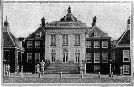
PALACE IN THE WOOD,
or Dutch “White House,” is situated in a fine old plantation of beeches and oaks, round ornamental lakes and islands, is a plain building with a grand interior; and has Jordaen’s masterpiece, the Apotheosis of Prince Fred. Henry.
The great Peace Conference was held here in 1899; The Hague is the seat of the resulting arbitration courts, for which Mr. Carnegie provided permanent buildings of great architectural beauty. Industries are iron-founding, copper and lead smelting, cannon-founding, printing, furniture and carriage making, and the manufacture of gold and silver lace.
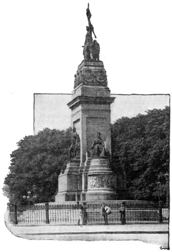
NATIONAL MONUMENT IN THE WILLEMS-PARK, THE HAGUE
History.—The ancient inhabitants of the country, the Batavians and the Frisians, became subjects or allies of the Romans in the first century A. D., and so remained till in the fourth century their territories were overrun by the Saxons and Salian Franks.
At the end of the eighth century the Low Countries submitted to Charlemagne, and various feudal dukedoms, counties, and lordships were gradually established (the countship of Holland in the eleventh century). In 1384 the earldom of Flanders passed to the Dukes of Burgundy, and Philip the Good (c. 1450) made the Low Countries as prosperous as any part of his Burgundian state.
The Emperor Charles V. inherited the Burgundian dominions; and under his son, Philip II. of Spain, broke out the bitter quarrel between Holland and Spain, between Dutch Protestantism and persistence and Spanish tyranny and persecution, which ended in 1581 in the establishment of the Dutch Republic as an independent state under William the Silent (of Orange), though the war continued with intervals till 1648, and the Belgian provinces abode by their allegiance to the kings of Spain.
In the seventeenth century Dutch commerce, especially at sea, Dutch science, Dutch classical scholarship, Dutch literature and Dutch art attained an eminence hardly afterwards equalled. The rivalry of Holland and England at sea led to the unfortunate wars of 1652-1654 and 1664-1667. The accession of William III. of Orange to the Stadtholdership of the United Provinces (1672) proved the salvation of the republic from France; in 1678 Louis XIV. signed the peace of Nymegen.
Ten years later William was hailed as the savior of English liberties, and became king of Great Britain and Ireland. On William’s death, the United Provinces became a pure republic once more, the stadtholdership was re-established in 1747 but it made no difference in the downward course.
The National Convention of France having declared war against Great Britain and the stadtholder of Holland in 1793, French armies overran Belgium (1794); they were welcomed by the so-called patriots of the United Provinces and William V. and his family (January 1795) were obliged to escape from Scheveningen to England in a fishing-smack and the French rule began. After several changes Louis Bonaparte, June 5, 1806, was appointed king of Holland, but, four years later, was obliged to resign because he refused to be a mere tool in the hands of the French emperor. Holland was then added to the empire.
The fall of Napoleon I. and the dismemberment of the French empire led to the recall of the Orange family and the formation of the southern and northern provinces into the ill-managed kingdom of the Netherlands, which in 1830 was broken up by the secession of Belgium. In 1839 peace was finally concluded with Belgium; but almost immediately after national discontent with the government showed itself, and William I. in 1840 abdicated in favor of his son.
Holland, being moved by the revolutionary fever of 1848, King William II. granted a new constitution, according to which new chambers were chosen, but they had scarcely met when he died, March, 1849, and William III. (born 1817) ascended the throne.
William III. having no living male issue, the succession to the crown was vested in the princess of Orange, Wilhelmina, the only child of the king’s second marriage, born in 1880. For many years the great question of internal politics was the new constitution, which, promulgated November 30, 1887, increased the electorate of Holland by no less than two hundred thousand voters. On the death of the king (November 23, 1890), when Luxemburg ceased to be connected with the crown of Holland, the Princess Wilhelmina became queen.
Queen Wilhelmina married Prince Henry of Mecklenburg-Schwerin, in 1901, and in 1909 a daughter (the Princess Juliana) was born to them.
NORWAY
NORWAY (Norweg. Norge), the western division of the Scandinavian peninsula, is one thousand one hundred and sixty miles in length (coast-line three thousand miles) and varies in width from twenty to one hundred miles north of 63° N. lat.; below that line it swells out to two hundred and sixty miles. The coast-line is extensive, deeply indented with numerous fiords, and fringed with an immense number of rocky islands. The surface is mountainous, consisting of elevated and barren tablelands, separated by deep and narrow valleys. The finest of the valleys stretching inland from the fiords is Romsdal, where the rounded pure gneiss mountains tower up to six thousand feet with almost perpendicular walls. The cultivated area is about one-thirtieth part of the country; forests cover nearly one-fourth; the rest consists of highland pastures or mountains.
Norway is separated from Sweden by the Kjolen Mountains (three thousand to six thousand feet), the backbone of the peninsula, which divide south of 63°; the western branch widens out into a broad plateau, undulating between two thousand and four thousand feet and embossed with mountain-knots—Dovre, Jotun, Lang, Fille, Hardanger Fjelde (fells)—the separate peaks of which shoot up to six thousand feet and higher.
Rivers.—The few important rivers that Norway can claim as exclusively her own have a southerly direction, and discharge themselves into the Skager-Rack; of these the chief are the Glommen (four hundred miles), and its affluent, the Lougen. The most important river in the north is the Tana, which forms part of the boundary between Russia and Norway, and falls into the Arctic Ocean. Lofty waterfalls are numerous. Lakes are extremely numerous but generally small. The principal is the Miösen Vand. The streams are turned to account in floating down the valuable timber of the forests, and their rapids give abundant mill power.
Production and Industry.—Agriculture, though pursued with some vigor of late, is unable to furnish sufficient products for home consumption; hence it has been necessary to import considerable quantities of corn, meat, and pork. The fisheries give employment to a large part of the population throughout the year. The most important are cod and herring. The mineral products are of late increasing.
The purely industrial establishments are grouped mainly around Christiania, and include textile factories, machine shops, chemical works, flour mills, breweries, etc. The use of water power for electrical enterprises is growing. The Norwegians rank among the busiest sea carriers of the world, the Norwegian mercantile marine ranking third among maritime nations, or first in proportion to population.
The chief exports consist of timber, matches, fish, oil, and other products of the fisheries, pulp, paper, skins and furs, nails, minerals, stone, ice, calcium carbide, condensed milk, butter, margarine, tinned goods, etc.
People.—The people of the peninsula are of Germanic race, with the exception of the small number of Finns and the Lapps in the north. The Norsemen of Norway, of middle stature, strong, generally blonde haired and blue eyed, seamen by choice, have adopted the Danish as the language of the towns and of literature, the modernized Old Norse being banished to the outlying country districts and unfrequented fiords.
Education is compulsory and free between the ages of seven and fourteen, schools being maintained by local taxation with state grants in aid. The attendance is high. Secondary schools are provided by the state, by local authorities, and privately. There are a number of special schools and industrial and technical institutes. The University of Christiania is an important institution for higher education.
Except 52,700 persons (including Methodists, Baptists, Roman Catholics, Jews, Mormons), the entire population belong to the Lutheran Church.
Government.—After the crisis of European affairs brought about by Napoleon’s wars, Denmark lost her hold over Norway, which had been united to it for more than four centuries, and that country was united to Sweden in exchange for Finland, which then passed under Russian sway. Norway, however, was again separated from Sweden as an independent kingdom under King Haakon VII. in 1905.
The Storthing or Parliament consists of one hundred and twenty-three members, women being eligible and electors (since 1907); and divides for legislative purposes into two chambers called “Odelsting” and “Lagting.”
The Norwegians share with the Swiss the distinction of being the most democratic people in Europe; all titles of nobility were abolished in 1821. In 1912 practically all offices except in the cabinet, diplomatic service, army, navy, and church, were thrown open to women.
Cities.—The chief cities are the capital, Christiania, and Bergen. Other important towns are Trondhjem, Stavanger, and Drammen.
Christiania, the modern capital and chief commercial town of Norway (the ancient capital is Trondhjem, “home of the throne,” where the kings are still crowned), is built on the northern end of the Christiania Fiord. Population, in 1910, 241,834. It is named after Christian IV., who commenced building it in 1624 after the destruction of the ancient city of Oslo by fire. It is the seat of Parliament, of the High Court of Judicature, and of the National University. Connected with this are the students’ garden, a library of four hundred and fifty thousand volumes, a botanical garden, zoological and other museums, laboratories, and observatory. The Meteorological Institute was established in 1866. There are two national and historical palaces here, one in the city quite near the university, and one, Oscarshall, beautifully situated two miles from the city on an eminence overlooking the fiord. There is a national picture-gallery, and a very interesting museum of northern antiquities. The Dom or Cathedral and Trinity Church are the principal ecclesiastical buildings. The old fortress Akershus Faestning still remains, but has little military value.
The staple industry of Christiania is its shipping trade; its chief export is timber. A considerable industry is the brewing of Christiania öl, a sort of lager beer, with resinous flavor, largely consumed throughout Norway, and exported. The minor manufactures are cotton, canvas, engine-works, nailworks, paper-mills, and cariole-making. The harbor is closed by ice for three or four months most winters.
History.—It is not until the ninth century that the story of Norway begins to emerge from the obscurities of myth and legend. At first it was occupied by Lapps and by several Gothic tribes, then became an independent kingdom, founded in 872, and was united to Denmark in 1380.
The Napoleonic crisis in Europe may be said to have severed the union, which had existed for more than four hundred years between Norway and Denmark. The latter country after having given unequivocal proofs of adhesion to the cause of Bonaparte, was compelled, after the war of 1813, to sign the treaty of Kiel in 1814, in which it was stipulated by the allied powers that she should resign Norway to Sweden. Charles XIII. was declared joint king of Sweden and Norway in 1818. From that time down to 1905 Norway remained in union with Sweden. In June of that year Norway declared the union dissolved, and the repeal of the union was signed in October of the same year. The throne was offered to and declined by a prince of the reigning house of Sweden, but was afterwards accepted by Prince Carl of Sweden, who was thereupon elected as King Haakon VII. In 1908 a treaty was signed by Great Britain, Germany, France, Russia, and Norway guaranteeing the integrity of the Norwegian kingdom.
Poland
Poland (called by the natives Polska, a word of the same root as Pole, “a plain”), a kingdom of Europe, proclaimed, in 1916, by the governments of Austria-Hungary and the German Empire as the result of conquests by the Central Powers, comprises substantially what is geographically known as Russian Poland (the kingdom of Poland formed in 1815) and Austrian Poland (or the Austrian province of Galicia). The former has an area of about 49,000 square miles, with a population of more than 12,000,000; the latter, an area of 30,300 square miles, and a population of 8,000,000.
Surface.—This extensive tract forms part of the great European central plain, and is crossed by only one range of hills, which run northeast from the Carpathians, forming the watershed between the Baltic and Black Seas.
Its principal streams are the Vistula, the Niemen, and the Dwina, all belonging to the basin of the Baltic; and the Dniester, South Bug, and Dnieper, with its tributary, Pripet, belonging to the basin of the Black Sea.
The physical configuration of the country makes it admirably adapted for agriculture. Next to grain and cattle its most important product is timber.
The soil is mostly a light fertile loam, though there are large barren tracts of sand, heath, and swamp, especially in the east. Much of the fertile soil is rich pasture land, and much is occupied with forests of pine, birch, oak, etc. Rye, wheat, barley, and other cereals, hemp, timber, honey, and wax, cattle, sheep, and horses, vast mines of salt and coal, some silver, iron, copper, and lead constitute the natural riches of the country.
People.—The present population of the provinces, included in the Poland of former days, consists chiefly of Poles, Lithuanians, Germans, Jews, Malo-Russians, Roumanians and Gypsies. The Poles, who number 10,000,000, form the bulk of the population; the Lithuanians, 2,100,000 in number, inhabit the northeast of the country; the Germans, of whom there are 2,000,000, live mostly in the towns; the Jews are very numerous being estimated, at 2,200,000.
Roman Catholics preponderate; then come in order the Greek Church, Protestants, Jews, and Armenians.
Cities.—The following are the populations of the chief cities: Capital, Warsaw, 800,000; Lodz, 400,000; Lemberg, 225,000; Cracow, 160,000; Przemysl, 60,000.
Warsaw (Polish Warszawa), the capital of Poland, stands on the Vistula’s left bank, three hundred and thirty miles east of Berlin by rail and seven hundred miles southwest of Petrograd. Two iron bridges lead to the suburb of Prague, on the opposite bank. Standing on a navigable river, with great railway lines to Moscow, Petrograd, Vienna, Danzig, and Berlin, Warsaw is one of the most important cities of eastern Europe, being smaller only than Petrograd and Moscow. Corn and flax are largely exported, and coal and manufactured goods imported. Warsaw itself manufactures electroplate, machinery, boots, woolens, pianos, carriages, tobacco, sugar, chemicals, beer, and spirits.
Of over one hundred Catholic churches the cathedral of St. John is the most notable; there are also several Greek churches, two Lutheran ones, and many synagogues. The castle is an imposing building, and there are many fine private palaces. The university, suppressed at various times, was reopened in 1915, and has seventy-five professors who now teach in Polish.
History.—The early history of Poland is legendary and obscure. The Poles, like the Russians, are a Slavonic race, and are first spoken of as the Polani, a tribe or people between the Vistula and Oder. The country was divided into small communities until the reign of Mieczyslaw I. (962-992) of the Piast dynasty, who renounced paganism in favor of Christianity, and was a vassal of the German emperor.
He was succeeded by Boleslaw the Great (992-1025), who raised Poland into an independent kingdom and increased its territories. In succeeding reigns the country was involved in war with Germany, the Prussians, the Teutonic knights, and with Russia. The last of the Piast dynasty was Casimir the Great (1364-1370), during whose reign the material prosperity of Poland greatly increased. He was succeeded by his nephew, Louis of Anjou, king of Hungary, whose daughter, Hedwig, was recognized as “king” in 1384, and having married Jagello, prince of Lithuania, thus established the dynasty of the Jagellons, which lasted from 1386 to 1572.
During this period Poland attained its most powerful and flourishing condition. In 1572 the Jagellon dynasty became extinct in the male line, and the monarchy, hitherto elective in theory, now became so in fact. The more important of the elective kings were Sigismund III. (1587-1637), Wladislaw or Ladislaus IV. (1632-1648), John Casimir, (1648-1669), and the Polish general Sobieski, who became king under the title of John III. (1674-1696). He was succeeded by Augustus II., Elector of Saxony, who got entangled in the war of Russia with Charles XII., and had as a rival in the kingdom Stanislaus Lesczynski. Augustus III. (1733-1763) followed, and by the end of his reign internal dissensions and other causes had brought the country into a state of helplessness.
In 1772 under the last feeble king Stanislaus Augustus (1764-1795), the first actual partition of Poland took place, when about a third of her territories were seized by Prussia, Austria, and Russia, the respective shares of the spoil being Prussia 13,415 square miles, Austria 27,000 square miles, Russia 42,000 square miles.
A second division between Russia and Prussia took place in 1793. Prussia received nearly all the present province of Posen, and the western part of what is now Russian Poland; Russia received all the territory east of about long. 44°. A third division between Russia, Prussia, and Austria occurred in 1795. Prussia took a large part of the present Russian Poland, including Warsaw; Austria received part of the present Russian Poland between the Bug, Vistula, and Pilica; and Russia received all the remainder, situated east of the Niemen and Bug.
An insurrection under Koszciusko had taken place in 1794, but he was defeated at the battle of Maciejowice and taken prisoner. Suvorov (Suwarrow), the Russian general, took Warsaw, and the Polish monarchy was at an end. King Stanislaus resigned his crown, and died at Petrograd in 1798.
Part of Poland was formed by Napoleon into the duchy of Warsaw. The Congress of Vienna in 1815 made a resettlement of the territory, creating a kingdom of Poland, under Russian rule, with a constitution. An insurrection which began in November, 1830, was suppressed in September, 1831; the constitution was abolished in 1832. From this time the independence of Poland was suppressed, and in 1832 it was declared an integral part of the Russian empire, with a separate administration, headed by a viceroy chosen by the Czar. On November 6, 1848, the republic of Cracow became Austrian; and the subsequent rebellion against Russian rule in 1863 only brought further humiliation on Polish hopes and aspirations.
During the European war Poland, in 1914, first suffered invasion and devastation by the Russian armies, and during the two following years was completely overrun by the Austro-German armies, and placed under the military rule of the latter. The proclamation of Poland as a new independent kingdom took effect in 1916.
PORTUGAL
PORTUGAL (named from Portus Cale, the Roman name of Oporto), a republic of Europe, lying between Spain and the Atlantic, on the west side of the Iberian Peninsula, is three hundred and fifty miles in length and varies in width from seventy to one hundred and forty miles. The area is 36,038 square miles—a little larger than Ireland.
Surface and Climate.—The coast is mostly low and flat, except immediately north and south of the mouth of the Tagus, and at Cape St. Vincent. The north of Portugal is diversified by spurs (five thousand feet) of the mountains of Spanish Galicia. The Sierra da Estrella (six thousand five hundred and forty feet) is a westward continuation of the Spanish Sierra Guadarrama system. The Sierra Morena is continued westwards in southern Portugal.
The principal rivers of the country—the Guadiana in the south, the Tagus in the center, and the Douro and Minho in the north—are simply the lower courses of Spanish rivers; but the Mondego has its sources in the country.
The vicinity to the ocean tempers the climate and exempts it from the dry heat of Spain. The inequalities of the surface produce, however, diversities of climate; for, while snow falls abundantly on the mountains in the northern provinces, it is never seen in the southern lowlands. Rain falls abundantly throughout the year.
Production and Industry.—The chief products are wheat, barley, oats, maize, flax, hemp, and the vine in elevated tracts; in the lowlands, rice, olives, oranges, lemons, citrons, figs, and almonds. There are extensive forests of oak, chestnut, sea pine, and cork, the cultivation of the vine and the olive being among the chief branches of industry; the rich red wine known to us as “port” is shipped from Oporto. Its mineral products are important—copper, lead, tin, antimony, coal, manganese, iron, slate, and bay salt, which last, from its hardness and purity, is in demand. Its manufactures consist of gloves, silk, woolens, linen, and cotton fabrics, metal and earthenware goods, tobacco, cigars, etc. The exports consist to the extent of fifty per cent of wine, which is the chief industrial product of the country; others are cork, cattle, copper ore, fruits, oil, sardines, and salt.
People.—The Portuguese are a mixed race—original Iberian or Basque, with later Celtic admixture. Galician blood (derived from the ancient Gallaici, presumably Gallic invaders) predominates in the north; Jewish and Arabic blood are strongly present in the center, and African in the south.
The Portuguese differ widely from their Spanish brethren, whom they regard with inveterate hatred and jealousy, mainly on account of their attempts to subvert the independence of Portugal.
Education is free and nominally compulsory between the ages of seven and fifteen, but is not strictly enforced, and over seventy-five per cent of the population above seven years old are illiterate. Secondary education is conducted in state lyceums. There are also military, naval and other special schools. The University of Coimbra is the chief higher institution.
Government.—Portugal was a constitutional monarchy till 1910, when a republic was established. The constitution of 1911 provides a Senate, elected by municipal councils, and a National Council, by direct suffrage. The two chambers united constitute the Congress of the republic. The president of the republic is elected by both chambers for a period of four years. He cannot be re-elected.
Cities.—Capital, Lisbon, on the Tagus, population, 435,359. Oporto had a population (1911) of 194,664. There are no other large towns, but Braga, Loulé, Setubal, and Funchal (Madeira) had populations exceeding 20,000 in 1911.
Lisbon (Port. Lisboa), capital of Portugal, stands on the northern shore of a bottle-shaped expansion of the Tagus, nine miles from its mouth; it is four hundred and twelve miles by rail west by southwest of Madrid. The city extends for four or five miles along the shore, and climbs up the slopes of a low range of hills, occupying a site of imposing beauty.
The oldest part of Lisbon is that which escaped the earthquake of 1755; it lies on the east, round the citadel, and consists of narrow, intricate streets, not over clean. It is still known by its Moorish name of Alfama. The western portions were built after the earthquake, with wide and regular streets, fine squares, and good houses. The summits are mostly crowned with what were formerly large monasteries.
The gloomy cathedral of the “patriarch,” built in 1147, restored after 1755, has a Gothic facade and choir. The large church of St. Vincent contains the tombs of the former royal (Braganza) family. The church of Estrella is a reduced copy of St. Peter’s at Rome. In San Roque is a chapel thickly encrusted with mosaics and costly marbles. But the finest structure in the city is the Gothic monastery and church of Belem, a monument to the great seamen of Portugal; it was begun in 1500 on the spot from which Vasco da Gama embarked (1497) on his momentous voyage. Inside the church are tombs to Camoens and Vasco da Gama, and the grave of Catharine, wife of Charles II. of England.
A fine square facing the bay is surrounded with government offices, the handsome custom-house, and the marine arsenal. There are an academy of sciences, with a library of one hundred and twenty thousand volumes, a polytechnic school, a medical school, a conservatory of music, a public library of four hundred thousand volumes and two observatories.
A magnificent aqueduct brings water to the city from springs nine miles to the northwest.
A series of forts protect the seaward approaches. The harbor is one of the finest in the world, well sheltered, deep close to the quays, and capacious enough to hold all the navies of Europe at once.
History.—Like the rest of Iberia, Portugal (the southern part of which was known to the Romans as Lusitania, often taken as a poetical name for the whole country) was thoroughly Romanized after the conquest of the Carthaginians by the Romans in 138 B. C. Then the peninsula was overrun by the Visigoths, and next by the Saracens. Northern Portugal fell under the influence of Castile; but under Alfonso I. (1143) Portugal became an independent kingdom, though the Saracens were not conquered in the south till 1250. Wars with Castile were frequent.
Under John (1385-1433) began a close alliance between Portugal and England, and the Portuguese king John married John of Gaunt’s daughter. With their son, Prince Henry the Navigator, began the most brilliant era of discovery and conquest, including the acquisition of Madeira, the Azores, and the doubling of the Cape of Good Hope (1486), the reaching of India by sea and settlements there (1497), and the discovery and occupation of Brazil (1500).
In the sixteenth century Portugal was one of the most powerful monarchies of Europe, and most prosperous of commercial peoples; but its decline was swift, and Philip II. annexed Portugal to Spain for sixty years. English assistance secured the independence of the kingdom in 1640; but the glory had departed. Portugal shared in the troubles of the French occupation and the Peninsular war; after Napoleon’s defeat, the old family, which had taken refuge in Brazil, was restored, but the country was rent by intrigue, dissension, and civil war.
The rush of the European powers to occupy central and southern Africa stirred Portugal to cling tenaciously to her once great colonial empire in Africa; but the march of events has given to Britain, Germany, France, and Belgium much that Portugal once claimed as hers.
Popular discontent culminated in the assassination of King Carlos and his eldest son in the streets of Lisbon in February, 1908. His second son, Manoel, succeeded. In 1910 the murder of Dr. Bombarda, a republican, hastened on a revolution already arranged for. The army and navy assisted in deposing Manoel and setting up a provisional government, with Theophile Braga as provisional president. He retired in 1911, and in August of that year Dr. Manoel Arriaga was elected as the first president of the republic.
The republic was formally recognized by the United States upon the meeting of the Portuguese chambers in June, 1911, and by the other powers on the formation of the cabinet in September, 1911. In 1915 Portugal joined the Entente Allies in the European war.
ROUMANIA
ROUMANIA, a kingdom in southeast Europe, lies mainly between the Carpathians, the Purth, and the Danube (the Dobruja being south of the Danube). It includes the strip added from Bulgaria as “compensation” for changes consequent on the Balkan war of 1912-1913, from a point on the Danube above Silistria to Cape Sabla on the Black Sea. Bordering on Hungary, Russia, Bulgaria, and Servia, its area is 52,000 square miles, and population 7,500,000.
Surface.—Roumania consists for the most part of a great treeless steppe-like plain, occupying nearly the whole of the northern watershed of the Lower Danube; behind this plain rise the wooded Transylvania Alps. Between the northern bend of the river to its marshy delta and the Black Sea there rises the bare plateau called the Dobruja, partly grass-covered, partly swampy, without tree or bush. This famous old battle-ground is crossed by Trajan’s double wall or rampart, built to keep the northern barbarians out of the Roman provinces.
Rivers.—All the rivers are tributaries of the Danube, and flow from the Carpathians and the Transylvanian Alps across the level steppe to join its left bank. The chief are the Pruth, which now forms the boundary towards Russia, the Sereth, and the Oltu (Aluta).
People.—Most of the Roumanians are supposed to be descendants of the race formed by the alliance of the Roman colonists with the original inhabitants of Dacia. The Roumanian language is derived mainly from Latin, with Slavonic, Hungarian, and other elements.
They are strong, well-knit men, with black hair, lively, but not very active. The mass of the people live in great poverty; a few thousand Boyars, nobles or landed proprietors, really form the nation. Large numbers of Jews and Gypsies live among the Roumanians. Almost the entire population belongs to the Greek Church, but religious equality prevails.
Government.—The constitution, voted by a popular assembly in 1866, vests the executive authority in the reigning king and his council of ministers; the legislative body consists of a Senate and a Chamber of Deputies.
Production and Industry.—The agricultural products consist of wheat, maize, millet, barley, rye, beans, and peas. Vines and fruits are abundant. The forests are of great extent and importance, but the riches of the country consist mainly in its cattle and sheep. Minerals and precious metals are said to be abundant, but only salt and petroleum are obtained.
Education is free and nominally compulsory, but owing to inadequate provision over sixty per cent of those above seven years of age are illiterate. Secondary education is relatively better, and the schools are well attended. There are also special schools and universities at Bucharest and Jassy. A government high school of commerce was opened in 1913.
Cities.—Capital, Bucharest, has a population (1912) of about 500,000. Other towns are: Jassy, 80,000; Galatz, 66,000; Braīla, 60,000; Ploesci, 50,000; Craiova, 46,000.
Bucharest (Bucuresci), the “Paris of the East,” stands two hundred and sixty-five feet above sea-level, in the fertile but treeless plain of the small, sluggish Dambovitza. By rail it is seven hundred and sixteen miles southeast of Vienna, forty miles north of Giurgevo on the Danube, and one hundred and seventy-nine miles northwest of Varna on the Black Sea. Viewed from the hills which lie to the west and southwest, Bucharest presents a most striking appearance. It is sprawled out on both banks of the river, occupying more than twenty square miles of territory in the slight depression through which the stream makes its way.
Most of its houses are low, not more than two stories, with flat roofs that shimmer in the sun. High above them rise almost innumerable towers, cupolas and minarets of churches, in which the city abounds. The Catholic Cathedral is a fine edifice, built 1875-1884.
Great spots and stretches of greenery mark the spacious parks and gardens and the great boulevards, some of which extend along the river bank, others out to the distant sections of the city.
Three of these thoroughfares skirt the river on the left, where the greater part of the city lies. They are the Plevna, Lipscani and Vacaresci, in order. From the Lipscani extend the Elizabeth Boulevard and Calea Victorie, the avenue of Victory, which connect with another broad highway extending nearly around the city on its outskirts.
Parks and drives are frequent. Then there are the botanical and zoological gardens, and a racecourse, where meets are held at least twice a year.
In these streets the East meets the West. Women gowned in the latest Paris creations and men in perfect European dress are in contrast with the wandering bands of gypsies, the brilliant-clad Roumanian country folk come in to market, the fez-topped Turk, and the distinctly dressed Russian cabmen.
Besides the parkways and busy thoroughfares there are many beautiful buildings—the National Bank, the Athenaeum, with its collection of rare antiques dating back to the days of the Roman conquest; the National Library and Theater; the University of Bucharest, founded in 1864; the many other schools and academies; the great home for the blind established by the late Queen Elizabeth, better known by her pen name “Carmen Sylvia”; a hundred-and-one other places that go to make the city notable as a center of learning, culture and modern progress.
Nearly all of these institutions have homes that are masterpieces of architecture. The Treasury Building and the Postoffice are notable examples. It is said that the Roumanian government has the finest home for its foreign ministry of any country in Europe.
Bucharest is the center for trade between Austria and the Balkan Peninsula, the chief articles of commerce being textile fabrics, grain, hides, metal, coal, timber, and cattle. It has been several times besieged; and between 1793 and 1812 suffered twice from earthquakes, twice from inundations, once from fire, and twice from pestilence.
History.—The Roumanians are descended from the ancient inhabitants—probably Thracians or Dacians—of the country, modified by elements derived from the Roman, Gothic, Bulgarian, and Slavonic invaders. Dacia was a Roman colony from 101 A.D. till 274, when it became the prey of successive swarms of wandering tribes.
Out of numerous small states, two, Wallachia and Moldavia, had become dominant, when they had to bow to the Turkish yoke, and became tributary to the Porte. They were governed by rulers nominated by the Porte, who were generally extortionate Greeks of Constantinople. Russian intervention during the eighteenth century somewhat improved the condition of the downtrodden principalities, which at times were wholly under Russian influence. In 1859 they elected the same prince, Couza. He ruled till he was deposed for misgovernment in 1866, and was succeeded by Prince Charles of Hohenzollern.
The Roumanians fought bravely on the Russian side in the Turkish war of 1877-1878, and at the end obtained complete independence, though they had to give Russia part of Bessarabia for the Dobruja. In 1881 the prince was recognized as a king.
Roumania is not a Balkan state, and took no part in the operations of the Balkan League (Bulgaria, Servia, Montenegro, and Greece) against the Ottoman Empire in 1912-1913; but during the second war (1913), when Bulgaria was in opposition to the remaining members of the League, Roumania was able to exact terms from Bulgaria at the Treaty of Bucharest, by which Bulgarian territory amounting to 7,609 square miles, with a population of 285,000, was surrendered to Roumania.
SERVIA
SERVIA (ser´vi-ä), a kingdom in the Balkan peninsula, southeastern Europe, is bounded by Austria-Hungary (separated by the Save and Danube) on the north, Roumania (separated by the Danube) and Bulgaria on the east, Turkey and Bosnia on the south, and Bosnia (mainly separated by the Drina) on the west.
Surface.—The greater part of the country is mountainous and wooded; it is full of forests and hills, hedged fields, and fresh meadows, forming pretty but never very grand landscapes. The principal river (besides the frontier rivers) is the Morava.
Production and Industry.—Nearly nine-tenths of the land is left under its primitive woods and pastures. The principal crops are maize for home consumption, and wheat for export; flax, hemp, and tobacco are also grown, and silk-culture is carried on to a limited extent. The exports consist of dried prunes, pigs, and wool, besides wheat, wine, hides, cattle, and horses. The bulk of the trade is with Austria. The mineral treasures of Servia are considerable; gold, copper, and zinc occur in the hills which reach towards the “Iron Gates” of the Danube, and coal beds extend along the river.
Fruit trees exist in very great abundance, especially plums, from which the brandy of the Servians (slovovitza) is extensively made.
People.—The Servians are a well-built, stalwart Slavonic (or perhaps in part Slavonized Albanian) race, proud and martial by temperament; the most striking feature of their social life is the family community or Zadruga. Their literature is rich in poetry, especially lyrics. The population, about 3,000,000 at the outbreak of the war of 1912-1913, was raised by conquests to about 5,000,000. Besides these the Montenegrins (450,000) are almost all pure Servians by race, as are also the Bosnians and Herzegovinians (2,000,000), not to speak of over 3,700,000 Servians in other parts of Austria-Hungary.
The people of Servia belong to the Greek Catholic Church. Education does not reach a very high standard, although a school exists in every commune. There is a university at Belgrade.
Government.—Servia is a constitutional and hereditary monarchy. The legislative power is vested in the king and the National Assembly. This last, called the Skupshtina, consists of one hundred and sixty deputies. Besides this body there is a senate of sixteen members, eight chosen by the king and eight by the National Assembly; this body acts as a permanent state council.
Cities.—Capital, Belgrade (Biograd, “White Fortress”) at the confluence of the Save and Danube, is now a modern city, with electric railways and light, and wide streets, containing the university, national museum and library, and the old Turkish citadel. Population (1910) 91,000. It lies opposite Semlin, at the confluence of the Save and Danube, two hundred and fifteen miles southeast of Budapesth. The walls disappeared in 1862; the last and finest of the five gates was demolished in 1868. Year by year the town is losing its old Turkish aspect, becoming more modern, more European. The royal palace, the residence of the metropolitan, the national theater (1871), and the public offices are the principal buildings. Opposite the theater is a bronze monument to the murdered Prince Michael III.
Belgrade has but trifling manufactures of arms, cutlery, saddlery, silk goods, carpets, etc. It is, however, an entrepôt of trade between Turkey and Austria.
Other towns are Nish, 25,000; Kragojevatz, 19,000; Leskovatz, 15,000; Podjeravatz, 14,000; Shabatz, 12,000; Vranya, 11,500; Pirot, 11,000; and Krutchevatz, 10,000.
The principal towns in the territories acquired in 1913 are Monastir, 60,000; Prisrend, 42,000; Uskub, 32,000; Prilip, 24,000; Istip, or Shtip, 21,000; Kalkandelen, or Tetovo, 20,000; Koprili, or Veles, 20,000; Dibra, 16,000; Pristina, 16,000; Kumanovo, 15,000; Ochrida, 15,000; and Novi Bazar, 13,000.
History.—The Servians came from the Carpathians in the seventh century, and founded a great state, which, about 1350, embraced Albania and much of Bulgaria and Macedonia; but at Kossovo in 1389 the Turks crushed the Servian power and made Servia first tributary and then a province of the Ottoman empire.
A national rising had some success under Kara George in 1807-1810 and through Russian influence it was arranged that Servia should have some measure of internal autonomy. Still more successful was a rising in 1815 under Obrenovich. Under his successors there was considerable progress; and after the Russo-Turkish war of 1877-1878 Servia obtained complete independence and became a kingdom. King Milan abdicated in 1889.
In 1903 a party of officers, representing a wide conspiracy, assassinated King Alexander and Queen Draga, and Peter Karageorgevitch was proclaimed king. In 1913 Servia, as a member of the Balkan League (Bulgaria, Greece, Servia, and Montenegro), waged a successful war against Turkey. In August, 1913, Servia and Greece were attacked by Bulgaria, their former ally, owing to disputes concerning the division of the spoils. The second war collapsed in a few weeks through the threatened intervention of Roumania, and ended in the Treaty of Bucharest. Servia also became involved with the Austro-Hungarian monarchy on a question of the Albanian frontier, where desultory fighting had taken place for some months, but eventually the smaller power withdrew from the disputed area. The outcome of the military operations was the inclusion of the whole of “Old Servia” (the greater part of Macedonia) within the Servian boundaries, which thus embrace an area (1914) of close on thirty-four thousand square miles, with a population estimated at five million.
The assassination of the Austrian heir presumptive, in June, 1914, brought about an invasion of Servia by the forces of Austria-Hungary, and started the Pan-European war that is still in progress.
SPAIN
SPAIN (Span. España), occupying the larger part of the southwestern peninsula of Europe, is bounded on the south and east by the Mediterranean, on the west by the Atlantic and Portugal, and on the north by the Bay of Biscay and France, from which it is separated by the Pyrenees. Its coast line extends 1,317 miles—712 formed by the Mediterranean and 605 by the Atlantic—and it comprises a total area of 196,700 English square miles, and a population (1910) of 19,588,688.
Surface.—The interior of the peninsula consists of an elevated tableland, surrounded and traversed by mountain ranges. The uniform coast line and the great elevation of its central plateau give Spain a more continental character in its extreme range of temperature than any of the other peninsulas of Europe.
Outside the plateau lie the highest summits in the country, the Pic de Néthou, in the Pyrenees, Mulhacen and Veleta in the Sierra Nevada, while the Picos de Europa in the Cantabrian Range attain over eight thousand feet. The plateau itself is traversed by four mountain ranges which separate the valley of the Ebro from that of the Douro; and the whole of it has a general slight inclination from east or northeast to southwest. Hence all the considerable rivers except the Ebro flow westward to the Atlantic.
These include the Guadalaviar, Júcar, and Segura, important rivers of the eastern watershed. The Minho, Douro, Tagus, Guadiana, and Guadalquivir drain the western valleys, which are formed between the mountain ranges of the Peninsula. The Tagus is the largest river of the Peninsula, the estuary of which forms a magnificent harbor. The Guadalquivir, though the shortest of the larger streams, is the most important on account of its fullness and its course through the most extensive lowland of the Peninsula. The effect of the tide in it is felt for several leagues above Seville, to which city it is navigable, eighty miles from the sea.
The configuration of the country renders the climate very varied. In parts of the northwest the rainfall is among the heaviest in Europe. In the east and southeast occasionally no rain falls in the whole year. The rainfall in the western Pyrenees is very great, yet on the northern slope of the valley of the Ebro there are districts almost rainless. The western side of the great plateau, speaking generally, is more humid and much colder than the eastern, where irrigation is necessary for successful cultivation.
Production and Industry.—Galicia is almost a cattle country; Estremadura possesses vast flocks of sheep and herds of swine. The country is generally fertile, and well adapted to agriculture and the cultivation of heat-loving fruits—as olives, oranges, lemons, almonds, pomegranates, and dates. The agricultural products comprise wheat, barley, maize, oats, rice, with hemp and flax of the best quality. The vine is cultivated in every province; in the southwest, Jerez, the well-known sherry and tent wines are made; in the southeast, the Malaga and Alicante.
Spain is rich in iron, copper and lead, but the mines have been only partially developed.
The seat of the manufacturing industries is chiefly Catalonia. Cotton and woolen manufactures engage many hands, and there are also considerable silk, paper, and cork industries.
The principal exports are wine, copper and copper ores, lead, iron ores, olive oil, raisins, oranges, cork, esparto grass, wool, salt, quicksilver, grapes, etc.
People.—The basis of the population of the whole Peninsula is that of the old Iberians, modified by the admixture of Celtic, Phœnician, Roman, Germanic, and Moorish (Arab) invaders who from time to time gained ascendency in the land and became intermixed with the ancient inhabitants.
Until lately the only religion tolerated was that of the state, the Roman Catholic; now a certain toleration is allowed to other denominations.
Education varies greatly among different classes and in different provinces. In the large towns and in some of the provinces a great effort is made to keep the higher and the technical schools on a level with the best in other European countries. In other parts the neglect is very great. There are ten universities: Madrid, Barcelona, Granada, Oviedo, Salamanca, Seville, Santiago, Valencia, Valladolid, and Saragossa. Primary education is by law compulsory, but the law is not strictly enforced, which accounts for the large percentage of illiterates.
Government.—The government of Spain is an hereditary monarchy founded on the constitution of 1876. The Cortes consists of two bodies—the Senate, of about three hundred and sixty members (one-half elected), and a Congress of Deputies, elected at the rate of one member to every fifty thousand inhabitants.
Cities.—The principal cities are Madrid, population 597,573; Barcelona, 587,219; Valencia, 233,348; Seville, 155,366; Malaga, 136,192; Murcia, 125,380; Saragossa, 111,701; Carthagena, 96,983; Bilbao, 93,536; and San Sebastian, 92,514; and there are also twelve towns with over 50,000 inhabitants.
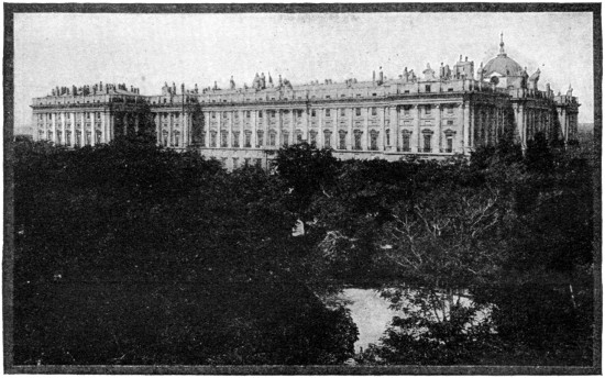
THE ROYAL PALACE, MADRID,
one of the finest in Europe, has a frontage of four hundred and seventy feet, is one hundred feet high, and built of white stone. Among the thirty rooms on the first floor, the largest and finest is the Hall of the Ambassadors. The vault was painted by Tiepolo, and represents the exaltation of the Spanish monarchs. The walls are draped with velvet embroidered with gold, and twelve immense mirrors also decorate it. On the right of the throne, which is guarded by four gilded bronze lions, is a statue of Prudence, and on the left that of Justice. The chapel is extremely rich, but not very handsome. There is also a library, a theatre, and the magnificent collection of Flemish tapestries.
Madrid (Span. pron. Madh-reedh´), the capital of Spain, is situated in the department of Madrid (part of the ancient province of New Castile), eight hundred and eighty miles by rail from Paris. It is built on a treeless, ill-watered plateau, on the left bank of the Manzanares, two thousand and sixty feet above the sea-level.
The Manzanares is merely a mountain-torrent falling into the Jarama, a tributary of the Tagus; water is brought from the Guadarrama Mountains by an aqueduct forty-two miles in length.
The general aspect of the city is clean and gay, while the older parts are picturesque; no trace now remains of the mediæval city. The new streets are generally fine, broad, and planted with trees; the houses well built, lofty, and inhabited by several families living in flats. A great feature is the magnificent open spaces, chief of which is the Prado, running north and south through the eastern part of the city, and, with its continuations, three miles long. It contains four handsome fountains with groups of statuary, a fine obelisk to commemorate the gallant struggle with the French (May 2, 1808), monuments to Columbus, Isabel the Catholic, etc.
The picture-gallery here, founded by Charles III., is one of the finest in Europe, and contains many of the masterpieces of Velasquez, Murillo, Raphael, Tintoretto, Rubens, Teniers, and Van Dyck. Two other parks are the Buen Retiro, the fashionable promenade on the east of the city, and the Casa de Campo on the west. Midway between its extremities the Prado is crossed at right angles by the Calle de Alcala, the finest street in the city, about a mile in length, and leading from outside the fine triumphal arch rebuilt by Charles III. to the Puerta del Sol, the square which is the heart of Madrid; here converge the principal electric lines, and in it and the streets branching off from it are situated the principal shops and places of business.
The finest square is the Plaza Mayor, formerly the scene of bull-fights; it contains a gigantic equestrian statue of Philip III., its founder. On the west of the city are the new cathedral and the royal palace; the latter, commenced in 1738 to replace the ancient Alcazar, which had been burned down, was finished in 1764 at a cost of fifteen million dollars. Other fine buildings are the palace of justice, formerly a convent; the houses of parliament; Buena Vista Palace, now the ministry of war, and the new national bank.
Besides a flourishing university, founded by Cardinal Ximenes, and two high schools, Madrid contains numerous municipal schools. Madrid is well provided with newspapers and public libraries, the chief being the National Library, with more than half a million volumes, and the library of the university.
The opera house is one of the finest in the world; all the theaters must by law be lighted by electricity. The bull ring, situated outside the gates on the east, is a solid structure seating fourteen thousand.
Iron founding and the manufacture of furniture, carriages, and fancy articles are carried on on a small scale. The manufacture of tobacco employs many persons, chiefly women. The publishing trade is important, and books are well printed and cheap. The old tapestry factory still turns out beautiful work, as do the potteries at Moncloa.
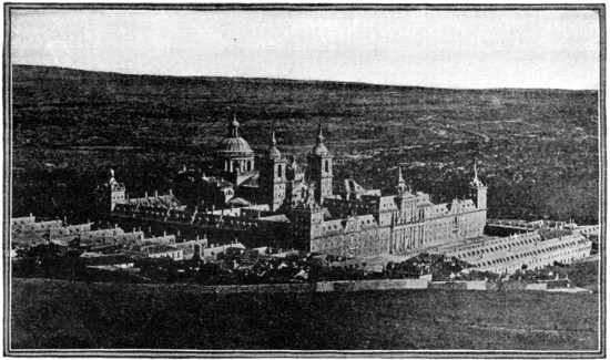
THE ESCURIAL
is thirty-two miles from Madrid. It is called by the Spaniards the eighth wonder of the world. Philip II. built it in 1685 to commemorate the taking of St. Quentin, and to accomplish a vow which he made to St. Lawrence. This vast building has fifteen principal entrances, and more than one thousand one hundred windows. It is entirely built of granite, and its appearance is monotonous and cold. It contains a church, the Capilla Mayor, filled with royal monuments, the sacristy, a vast vaulted hall with a marble altar ornamented with bronze, the choir, and the pantheon or vault, where the kings of Spain are buried. The pantheon is reached by a magnificent staircase of colored marbles. The urn containing the remains of Charles V. was opened in 1870, and the body was even then in perfect preservation. The library of books and the manuscript library attracts the attention of scholars. The main entrance to the palace is in the middle of the north façade. The Hall of Battles, is covered with frescos representing Spanish conquests; and the apartments in which Philip II. lived and died. The Pavilion of Charles IV., called the Casa del Principe, is a charming little museum of paintings, sculptures, and mosaics. The King’s Seat, where Philip II. came to sit when presiding over the work of the palace, is also to be seen.
History.—Spain was originally occupied by Iberian tribes (akin to the present Basque inhabitants of the north), who were partially overlaid by invading Celts. The Carthaginians established themselves in the south of Spain in the third century B. C. The Romans appeared in force in the next century, but it was not till after a fierce and prolonged resistance from Iberians and Celtiberians that, under Augustus, the Roman conquest was complete. Soon Spain, thoroughly Romanized, was contributing largely to Latin literature and Roman culture.
The Germanic invaders from the north, Suevi, Vandals, and Visigoths, crushed the Roman power in the fifth century A. D., and Spain became a province of the Visigothic kingdom (573 A. D.). Then followed the Moorish conquest, which was very rapid (714-732) and complete, except in the north and northwest. The several Christian kingdoms of Spain: Castile, Leon, Navarre, Aragon, etc., as well as Portugal—were formed by the gradual depression of the Moors; but Moorish Granada was not conquered till 1492, and Spain was not united under one rule till 1512.
Spain became a European state with the union of Ferdinand of Aragon and Isabella of Castile in 1469, and the New World was discovered for them. Under the Emperor Charles V., in the sixteenth century, Spain was the most important country in Europe; but the population was unequal to the drain upon it caused by constant warfare, emigration, and adverse economical and industrial conditions.
With Philip II., Charles’s son, the decline of Spain set in, though now for sixty years Portugal was under the Spanish crown. The Bourbon dynasty brought complication in the wars of Louis XIV., and little advantage from the recovery of Naples and Sicily. The nadir of Spanish history is in the time of Napoleon, when Spain, in spite of some national efforts, was nominally a kingdom, but really a mere province of the French empire.
In spite of the valiant patriotism shown in resisting the French, and the ultimate recovery of national independence through the overthrow of Napoleon, the history of Spain in the nineteenth century was in the main inglorious. In Cuba there had been trouble since 1895, the final outcome of which was the disastrous Spanish-American war, leading to the loss of the greater colonies. The twentieth century has seen gradual recovery, growing toleration, a breach with the Vatican, revolutionary and repressive movements, and ambitions in northwest Africa.
In June, 1911, the situation in Morocco led to the dispatch of a Spanish force to Alcazar. But the indignation aroused in France at this action was quite overshadowed by the sensation caused when it became known that Germany had sent a warship to Agadir. Labor troubles in Spain broke out in September, 1911. Martial law was proclaimed throughout the country, and a royal decree suspended the constitutional guarantees, which were not re-established until October 22. In March, 1912, the ministry was reconstituted, but, in 1916, during the European war, again gave way over grave questions over neutrality and internal conditions.
SWEDEN
SWEDEN (Swedish Sverige), a kingdom of northern Europe, occupies the eastern side of the Scandinavian peninsula. From 1814 till the amicable but definitive separation in 1905, it was associated with Norway under one crown. Its greatest length, north to south, is close to 1000 miles, its greatest breadth 300; its area 170,970 square miles; and its coast line 1550 miles. Besides many skerry islands, Sweden owns Gothland and Œland.
Surface.—The country may be generally described as a broad plain sloping southeastward from the Kjölen Mountains to the Baltic. The only mountainous districts adjoin Norway; the peaks sink in altitude from seven thousand feet in the north to three thousand eight hundred feet at the southern end of the chain. Immediately south of this point a subsidiary chain strikes off to the southeast, and, threading the lake region of central Sweden, swells out beyond into a tableland with a mean elevation of eight hundred and fifty feet and maximum of twelve hundred and forty feet. Fully two-thirds of the entire surface lies lower than eight hundred feet, and one-third lower than three hundred feet, above sea level.
Sweden is separated popularly and geographically into three great divisions—Norrland, Svealand, and Gothland. Norrland, in the north, is a region of vast and lonely forests and rapid mountain streams, often forming fine cascades and ribbon-like lakes before they reach the Gulf of Bothnia.
The central division of Svealand, or Sweden proper, is a region of big lakes, and contains most of the mines. Lakes occupy nearly fourteen thousand square miles, or eight and two-tenths per cent of the total area; several of the largest, as Vener, Vetter, Hjelmar, Mälar, are connected with one another and the sea by rivers and canals. Lake Mälar contains some thirteen hundred islands, many beautifully wooded, with royal palaces or noblemen’s castles; and its shores are studded with prosperous towns, castles, palaces, and factories.
Gothland, the southern division, contains a much higher proportion of cultivated land, and its wide plains are all under agriculture.
Climate.—The climate of Sweden is continental in the north, along the Norwegian frontier, and on the southern plateau. The lakes in the colder districts of the north are ice bound for some two hundred and twenty days in the year; in the south only for about ninety days. The rainfall is greatest on the coast of the Cattegat.
Production and Industry.—The principal articles of cultivation are the various cereals—oats, rye, barley, wheat—and potatoes. The forests are very extensive, covering one-half of the surface of the country, and consisting of pine, birch, fir; these are of great importance, supplying timber, pitch, and tar, and also the chief fuel.
The mineral products are extremely rich: iron of excellent quality, that known as the Dannemora iron, being converted into the finest steel; gold and silver in small proportions; copper, lead, nickel, zinc, cobalt, alum, sulphur, porphyry, and marble. There is a railroad opening up the rich iron ore districts of Lapland, and mineral trains run from Gellivare and Kiruna to Lulea on the Gulf of Bothnia and to Narvik on the Atlantic. Considerable mines of coal are worked in Scania.
The chief articles of export are timber, butter, iron, steel, wood pulp, paper, matches, stone, iron and zinc ores, etc.
People.—The Swedes are a Germanic people, tall and strong, but with more variety of characteristics than the Norwegians. The Swedish language, allied closely to Norse and Danish, appears in very many dialects. It has had, especially since the sixteenth century, an extensive literature.
Almost the whole population is Protestant, adhering to the Lutheran Church, members of which alone are permitted to hold public offices. Education is well advanced in both countries, public instruction being gratuitous and compulsory. Sweden has the Universities of Upsala, which dates from 1477, and of Lund, founded in 1668, besides the many scientific and educational institutions of Stockholm.
Government.—The constitution of Sweden dates from 1809, but in 1866, when the separate meetings of the four estates—nobles, clergy, burghers, and peasants—were done away, the legislative system was much modified. The executive power is vested in the king, acting under the advice of a Council of State; the legislative in the two Chambers of the Diet, both of which are elected by the people—the first for nine years from proprietors, the second for three years from a lower class. The administration of justice is entirely independent of the government.
Cities.—The capital, Stockholm, has a population (1913) of 382,085. In addition to the capital, there are fourteen towns with above 20,000 population, viz.: Göteborg, 178,030; Malmö, 95,821; Norrköping, 46,180; Gefle, 35,736; Helsingborg, 37,385; Örebro, 33,182.
Malmö, on the sound opposite Copenhagen, is the outlet of the corn granary of the southern plain; Norrköping, on an inlet of the Baltic, after Stockholm, is the busiest manufacturing town of Sweden, its mills being driven by the rapids of the Motala; Gefle lies north of Stockholm, and is second only to it as a seaport on the Baltic side of the country; and Karlskrona, on the south coast, is the naval arsenal and headquarters of the fleet of Sweden.
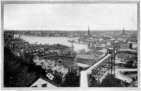
PANORAMA OF STOCKHOLM, CAPITAL OF SWEDEN
Within recent years a network of railways has been formed over southern Sweden and Norway, connecting the capital towns with the ports of Göteborg, Malmö, and many other points.
Stockholm (l pronounced), stands on several islands and the adjacent mainland, between a bay of the Baltic and Lake Mälar, in a situation that is accounted one of the most picturesque in Europe.
Its nucleus is an island in mid-channel called “the Town”; on it stand the imposing royal palace; the chief church (St. Nicholas), in which the kings are crowned; the House of the Nobles; the town house; the ministries of the kingdom; and the principal wharf, a magnificent granite quay, fronting east.
Immediately west of the central island lies the Knights’ Island (Riddarholm); it is almost entirely occupied with public buildings as the old Houses of Parliament; the old Franciscan church, in which all the later sovereigns of Sweden have been buried; the royal archives, and the chief law-courts.
North of these two islands lie the handsomely built districts of Norrmalm, separated from them by a narrow channel, in which is an islet with the new Houses of Parliament. In Norrmalm are the National Museum with valuable prehistoric collections, coins, paintings, sculptures; the principal theaters; the Academy of Fine Arts; the barracks; the Hop Garden, with the Royal Library, two hundred and fifty thousand volumes and eight thousand manuscripts, and with the statue of Linnæus; the Academy of Sciences; the Museum of Northern Antiquities; the Observatory, etc.
Ship Island (Skeppsholm), immediately east of “the Town” island, is the headquarters of the Swedish navy, and is connected with a smaller island on the southeast, that is crowned with a citadel. Beyond these again, and farther to the east, lies the beautiful island of the Zoological Gardens. Immediately south of “the Town” island is the extensive district of Södermalm, the houses of which climb up the steep slopes that rise from the water’s edge. Handsome bridges connect the central islands with the northern and southern districts; quick little steamboats go to the beautiful islands in Lake Mälar on the west, and eastward toward the Baltic Sea, forty miles distant.
Sugar, tobacco, silks and ribbons, candles, linen, cotton, and leather are produced, and there are large iron foundries and machine shops. Though the water approaches are frozen up during winter, Stockholm exports iron and steel, oats and tar.
Stockholm was founded by Birger Jarl in 1255, and grew to be the capital only in modern times.
History.—Sweden was originally occupied by Lapps and Finns, but probably (1500 B. C.) Teutonic tribes drove them into the forests of the north, and at the dawn of history we find Svealand occupied by Swedes (Svea) and Gothland by the Goths.
Gothland was christianized and also conquered by the Danes in the ninth century, while Svealand remained fanatically heathen till the time of St. Eric (twelfth century), who conquered Finland, henceforth a Swedish possession. For a century Goths and Swedes had different kings, but gradually melted into one people toward the end of the thirteenth century.
Now arose bitter feuds between king, nobility, peasants, and universal turbulence prevailed; agriculture, industry, literature and culture progressed not at all or hardly existed. Even after the union of Sweden, Norway, and Denmark under one monarch (1397), Sweden was torn by conflicts which lasted down to the expulsion of Danish oppressors, and the restoration of Swedish autonomy by the national rising under Gustavus Vasa (1524), the ablest prince who had yet ruled the Swedes. Under him the reformation was heartily accepted. Gustavus Adolphus and the Swedes were its bulwark, not merely at home but in Germany in the Thirty Years’ war; and by the acquirement of Bremen, Verden, and Pomerania, Sweden became (1648) a member of the empire.
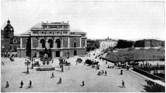
GUSTAVUS ADOLPHUS PLACE AND THE ROYAL THEATER, STOCKHOLM
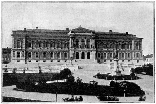
NEW UNIVERSITY, UPSALA, SWEDEN
Upsala is best reached by boat from Stockholm. Here the celebrated university, founded 1477, by Jacob Ulfson, now magnificently housed, stands in the Drottninggatan. Library, the largest in Sweden, with three hundred thousand volumes, including the Codex Argenteus, or Gothic Gospel of Bishop Ulphilas (318-388), written in silver letters on purple vellum, also the Atlantica of Rudbeck, and the sacred book of the Druses, with the Edda Manuscript. An Observatory is attached to the University. The Botanical Garden has many rare plants and a bust of Linnæus (Linné), who was professor and physician here, living at Hammarby.
Under Charles XII. and his successor, the enmity of Denmark, Poland, and Russia wrested her new conquests from Sweden, and gave Livonia, Esthonia, Ingermanland, and Karelia (which had long been Swedish) to Russia; thus reducing Sweden from the rank of a first-rate European power. After a bloody struggle Sweden had to cede Finland (1809) to Russia. Norway was united by a personal union (i. e., by the monarch) with Sweden in 1810; and in 1818 the French general Bernadotte was elected king (as Charles XIV.).
Norway’s demand for a larger measure of home rule led in 1905 to a complete separation.
SWITZERLAND
SWITZERLAND (Ger. Schweiz; Fr. Suisse), is a confederation of twenty-two cantons, lying practically in the very center of Europe, between France, Germany, Austria, and Italy. No part of it is within one hundred miles of the sea. It is also a very small country (sixteen thousand square miles), not much larger than the half of Scotland. The greatest length from east to west is two hundred and sixteen miles, the width from north to south being one hundred and thirty-seven miles. The population in 1910 was 3,741,971.
Surface.—The southern boundary lies for the most part along the highest crests of the Alps, which descend by the Italian valleys to the plain of Lombardy; the summits of the Matterhorn and Monte Rosa rise on the boundary line, which is crossed by the Great St. Bernard, Simplon, and Splügen passes. North of this mass of heights the deep valleys of the Upper Rhone flowing west to the Lake of Geneva, and of the Upper Rhine flowing northeast to that of Constance, mark a deep trench all across the country. In the heart of the country rises the mass of the Bernese Alps or Oberland, the Alps of Uri and Glarus, with the summits of the Finsteraarhorn and Jungfrau. Still farther north the country descends gradually by less elevated mountains and hills to the undulating lowland of Switzerland (still one thousand five hundred feet above the sea), which extends in a curve from the Lake of Constance on the northeast along the Valley of the Aar, by the Lakes of Biel (Bienne) and Neuchâtel to that of Geneva. Beyond this the long parallel ranges of the Jura close in the country on the northwestern frontier.
More than half of the whole country is covered by rocks, glaciers, forest, and mountain pasture, and cannot be permanently inhabited.
Rivers and Lakes.—All the northern part of the country belongs to the basin of the Rhine flowing to the North Sea. That river, having purified its waters in its passage through the Boden-See or Lake of Constance (partly in Switzerland), is joined by the Aar, which rises near the Grimsel, and flows through the lakes of Brienz and Thun. To this basin also belong the lakes of Zürich and Zug, Luzerne, Neuchâtel, and Biel or Bienne. The southwestern district drains by the Rhône to the Mediterranean, through the Lake of Geneva or Leman, which is partly in Switzerland, partly in France.
The smaller part of the southern boundary that laps over the Italian valleys of the Alps includes the head of Lake Maggiore, in Switzerland, and the upper Ticino, which flows through it to the plain of Lombardy and the Adriatic. In the east the boundary embraces only one valley, which drains to the Danube, the Engadine, through which the Upper Inn flows northeastward.
From the elevation at which they rise, and their rapids, the rivers of Switzerland are of no value in navigation. The Rhine only begins to be freely navigable at Basel, where it leaves the country. The larger lakes, however, have little steamers plying from shore to shore; that of Geneva, forty-seven miles long, has a considerable traffic.
Climate and Scenery.—The climate naturally varies with the elevation above the sea level, from that of the perennial snows at an elevation of about nine thousand feet, downward through the pastoral alpine region and the tall pine forests, to the lower lands in which the chestnut flourishes, and where orchard fruits, the vine, mulberry, and wheat can be grown. There is a variation of about thirty-four and one-half degrees in the mean temperature—between fifty-four and one-half degrees Fahrenheit at Bellinzona, and twenty degrees on the Theodule Pass.
Switzerland has been called the playground of Europe, and is visited by large numbers of tourists from all parts of the world, attracted by its magnificent mountain and lake scenery.
The amount of money brought annually by tourists is estimated at twenty million dollars.
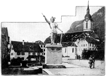
STATUE OF TELL, ALTDORF, SWITZERLAND
Altdorf, near the southern end of Lake Luzerne, and capital of the canton of of Uri, is in the mountain-walled valley, and is the reputed scene of Tell’s shooting the apple. The side is marked by a fountain. The colossal statue of Tell is near by. His birthplace, near Bürglen, is occupied by a frescoed chapel.
Geneva and Lausanne, on the beautiful lake of Geneva, Interlaken (between the lakes of Thun and Brienz), Luzerne and the Rigi, Schaffhausen at the Rhine fall, Zermatt beneath Monte Rosa, Lugano in the heart of the Italian lake district, are notable tourist stations; St. Moritz in the Engadine, and Leuk (Louèche) in the Rhone Valley, Pfäffers in that of the Upper Rhine, are famous for their baths. Switzerland as a whole—with its mountains, lakes, glaciers, waterfalls, valleys and cities—has been described by an American poet as a “cluster of delights and grandeurs.”
Production and Industry.—The forests, which cover about a sixth of the surface, are of immense value to the country, where most of the houses are built of wood. The mountain pastures give the characteristic employments of the people of the Alps and Jura, as herdsmen and shepherds, tending their cattle and making cheese in the mountain châlets during summer.
Agriculture is followed chiefly in the valleys, where wheat, oats, maize, barley, flax, hemp, and tobacco are produced.
The textile industries are the most important, the chief centers being Zürich, Basel, Glarus, and St. Gall. The chief are silk, cotton, and linen fabrics, besides raw silk. Next comes the clock and watchmaking industry, established at Geneva in 1587, which spread to the cantons of Neuchâtel, Berne and Vaud.
Wood carving was introduced in the Oberland about 1820. Other manufactures are chemicals, chocolate, and condensed milk.
Salt, obtained on the banks of the Rhine, is the only valuable mineral of the country.
People.—Three-fourths of the population of Switzerland, occupying all the center and north of the country, are Germanic; the remaining fourth belongs to three branches of the Romanic family—the French in the west, the Italian in the south, and the Rhæto-Romanic in the southeast. A little more than half of the population is Protestant, the remainder, chiefly in the mountain region, Roman Catholic.
Education is widely diffused, especially in the Protestant districts of the northeast, where the law of compulsory education is rigidly enforced. There are universities at Basel, Berne, Zurich, Geneva, and Lausanne.
Government.—At the close of the political storms which raged in Europe from 1789 till 1815, the affairs of Switzerland were re-arranged by the Congress of Vienna, which provided for the perpetual neutrality and independence of Switzerland in its twenty-two cantons. Since 1848 the independent states or cantons of Switzerland have become a united confederacy (Bundes Staat), the supreme legislative and executive authority of which is vested in a parliament of two chambers, sitting at Berne—the Stände Rath or States Council, and the National Rath, the first composed of two members for each canton, the second of representatives of the people according to numbers. The cantons are still, however, in a great measure, independent democracies, each making its own laws and managing its local affairs.
Referendum and Initiative.—These are two political institutions peculiar to Switzerland, the furthest developments of democracy yet attained.
The referendum, which has now spread throughout the whole Confederation, and by means of which all legislative acts passed in the Federal or Cantonal Assemblies may be referred to the people en masse, was fully developed in 1874, and it has been put in operation on an average once a year. The decisions have generally shown a conservative rather than a radical tendency on the part of the people.
Initiative is the exercise of the right granted to voters to initiate proposals for the enactment of new laws or for the alteration or abolition of the old ones.
Cities.—The capital of the Swiss Confederation is Berne, population (1910) 85,650. In 1910 there were twelve communes with populations exceeding 20,000: Zürich, 190,733; Bâle, 132,280; Geneva, 123,160; Berne, 85,650; Lausanne, 63,296; St. Gall, 37,657; Chaux-de-Fonds, 37,626; and Luzerne, 39,152.
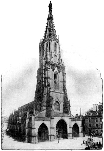
THE BERNE CATHEDRAL
was built in 1421-1573, and restored in 1850, with a richly sculptured portal, some good stained glass of the fifteenth century, and a famous organ. From the Terrace in the rear of the Cathedral, the snowy peaks of the Bernese Alps are seen in a glorious panorama.
Berne, since 1849 the capital of Switzerland, sixty-eight miles by rail southwest of Basel, is situated on a lofty sandstone promontory formed by the winding Aar, which surrounds it on three sides. It is one of the best and most regularly built towns in Europe, as it is the finest in Switzerland. The houses are massive structures of freestone, resting upon shop-lined arcades. Rills of water flow through the streets. The view of the Alpine peaks from the city is magnificent.
The principal public buildings are a Gothic cathedral, the magnificent Federal Council Hall, the mint, the hospital, and the university. Berne has an interesting museum, and a valuable public library of fifty thousand volumes.
It was founded in 1191, was made a free imperial city in 1218, under Frederick II.; and between 1288 and 1339 successfully resisted the attacks of Rudolf of Hapsburg, Albert, his son, and Louis of Bavaria. The “Disputation of Berne” between Catholics and Reformers in 1528 prepared the way for the acceptance of the reformed doctrine.
On account of the traditionary derivation of its name (Swabian bern, “a bear”), bears are maintained in a public bear-pit.
History.—The original inhabitants of Switzerland were the Celtic Helvetii, and the Rhætii of doubtful affinity. Both were conquered by Julius Cæsar and the generals of Augustus, and Romanized. Overrun by the Burgundians in the west, and their Germanic kinsmen the Alemannians in the east, Helvetia became subject to the Frankish kings and were christianized in the seventh century.
Most of the country was subsequently part of the Holy Roman Empire; and in 1273 a Swiss noble, Rudolf of Hapsburg in Aargau, became German emperor. Soon after his death (in 1291) the inhabitants of Uri, Schwyz, and Unterwalden formed a league to defend their common interests, and in 1315 crushed an Austrian army at Morgarten. In 1332 Luzerne joined the alliance, and in 1353, Berne, Zürich, Glarus, and Zug. The Austrians were again routed in Sempach in 1386, and in 1388 at Näfels.
The Swiss next had a fierce but triumphant struggle with Charles the Bold of Burgundy, whom they routed at Grandson and Morat in 1476, and finally at Nancy (where Charles was slain) in 1477.
When the Reformation began there were thirteen cantons, and the cantons took opposite sides from the beginning, not without serious turmoil and bloodshed. The treaty of Westphalia in 1648 recognized Switzerland as an independent state. Some of the cantons were strictly aristocratic and some highly democratic, and there was much discontent long before the French Revolution, when, in 1798, between civil strife and French armies, the old republic (or rather alliance) came to an end.
The Helvetic Republic of nineteen cantons, under French auspices, endured till 1805; then a new republican constitution was adopted, the Federal Pact of twenty-two cantons. On Napoleon’s downfall, Valais, Neuchâtel, and Geneva, which had been incorporated with France, were restored, and Swiss neutrality and inviolability were recognized by the treaty of Vienna in 1815. Religious troubles led to a Catholic league in 1844, which was suppressed by the Federal forces in 1847. The present constitution was adopted in 1848, but revised in 1874. In 1891 a demand for popular initiative for measures was carried. In 1908 Switzerland entered into an international convention for compulsory arbitration at the court of the Hague.
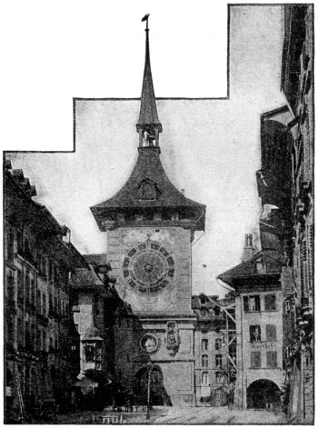
BERNE CLOCK TOWER,
famous for its Bear Chimes—figures which perform every time the clock strikes.
TURKEY, or Ottoman Empire
TURKEY, or Ottoman Empire, comprises the wide but heterogeneous territories really or nominally subject to the Osmânlî Sultan, in Europe, Asia, and Africa. These territories, which once extended from the Danube to the cataracts of the Nile, and from the Euphrates to the borders of Morocco, have been greatly reduced in the nineteenth and twentieth centuries.
Asiatic Turkey is now the true center of gravity of the empire; it includes Anatolia (the great plateau of Asia Minor), the lowlands of Mesopotamia, the highlands of Kurdistan and Armenia, and the island of Samos. The total area of the empire has been estimated as follows:
Area in Square Miles
Turkey in Europe 12,000
Turkey in Asia:
Anatolia 193,800
Armenia and Kurdistan 72,600
Mesopotamia and Syria 244,460
Turkish Arabia 172,000
Total 694,860
Estimated Population
Turkey in Europe 2,755,000
Turkey in Asia:
Anatolia 9,175,000
Armenia and Kurdistan 2,500,000
Mesopotamia and Syria 4,650,000
Turkish Arabia 1,100,000
Total 20,150,000
Of the above totals only 700,000 square miles (with a population of 21,000,000) are directly under Turkish government.
European Turkey consists of the provinces of Adrianople, Constantinople and Chatalja, and is separated from Asia by the Bosphorus at Constantinople and by the Dardanelles (Hellespont), the only political neighbor being Bulgaria, on the northwest.
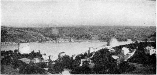
PANORAMA OF THE BOSPHORUS AT THE NARROWEST PART
The Bosphorus, the straight connecting the Sea of Azov with the Black Sea, is so-called after Io, who swam over it in the shape of a heifer. On the western shore is the city of Constantinople. The Bosphorus at this point is about five hundred and fifty yards wide.
Physical Features.—Turkey in Europe is a mountainous country and the chief physical features as it is now limited is the strait of Bosphorus and the Dardanelles. The Bosphorus, which guards the approach to the Black Sea from the Sea of Marmora, is at the same time the focus of all maritime trade between the Mediterranean and Russia, etc., as well as of the overland routes from Europe into Asia Minor. It has fitly been likened to a tortuous river valley over whose wooded banks are scattered forts and towers, cities and villages, castles and parks. The southern gate of the Sea of Marmora is the Dardanelles, which gives an opening into the Ægean.
Turkey in Asia is still more mountainous. The two almost parallel ranges, Taurus and Anti-Taurus, which are the basis of its mountain system, cover almost the whole of the peninsula of Asia Minor or Anatolia with their ramifications and offshoots, forming the surface into elevated plateaus, deep valleys, and enclosed plains. From the Taurus chain the Lebanon range proceeds southwards parallel to the coast of Syria, and, diminishing in elevation in Palestine, terminates on the Red Sea coast at Sinai.
The Euphrates, Tigris, Orontes, and Kizil-Ermak are the chief rivers. (See Asia Minor.)
Climate.—The climate of Turkey in Asia is as varied as the physical features. The great plateau on the north has a distinctly continental climate, rigorous severe winters with intense scorching heat in summer; in the eastern part of the plateau region the mountains are covered with snow for two-thirds of the year, and some of the principal ranges are capped with perpetual snow; here the peasants build their dwellings underground to escape the severity of the seasons. Towards the west the winters are not quite so severe, but the variations of temperature are excessive.
Products and Industry.—The soil of European Turkey is for the most part very fertile, and the cultivated products include most of those usual in central and southern Europe—maize, rice, rye, barley, millet, besides tobacco madder, and cotton. The mineral products are iron in abundance, argentiferous lead ore, copper, sulphur, salt, alum, and a little gold; some deposits of coal have been found, but none are worked. Sheep-breeding is largely carried on.
In Asiatic Turkey the mineral wealth is great; coal and iron are found together in considerable quantities; rich mines of copper exist in the mountains on the south of the Black Sea, and in the Taurus near Diarbekir lead and silver are found at intervals along a line connecting Angora, Sivas, and Trebizond in the north, and the eastern Taurus in the south; green, black, and white marble, and the finest quality of granite, are to be had in many parts of the mountain section.
With a fertile arable soil and a suitable climate, nearly every agricultural product flourishes. Oats, barley, and wheat are produced in great abundance. Almost all kinds of garden produce and orchard fruits abound, grapes and oranges are to be had all round the Mediterranean coast, as well as the choicest tobacco, opium, valonia and madder.
The mulberry is everywhere cultivated for feeding the silkworms, and cotton is grown in most of the western valleys. Vast groves of boxwood and other valuable trees clothe the seaward slopes of the hills. Dates are produced for export in the Babylonian plain, where wheat is indigenous. Petroleum and bitumen springs are found in the Euphrates valley.
Angora is famous for its flocks of goats, which produce the mohair of commerce, and enormous quantities of wool come from the countless flocks of sheep tended by the wandering Bedouin and Kurd shepherds.
There are at present no manufactures worth mention. The sponge fisheries of the Mediterranean are a source of great wealth.
Commerce.—The exports include tobacco, cereals, fruits, silk, opium, mohair, cotton, coffee, skins, wool, oil-seeds, valonia, carpets, etc., and are largely derived from the Asiatic provinces. Recently large quantities of wine and of raisins for the manufacture of wine have been exported. Since the establishment of the Anatolian railway by German enterprise the export of cereals, chiefly malting barley, has largely increased.
People.—The population consists of a singular mixture of races. Turks, Greeks, Slavs, and Albanians are largely represented, besides Armenians, Kurds, Arabs, Tartars, Jews, Circassians, and Frank residents. (See Book of Races.)
The established religion is Islam or Mohammedanism, but most other creeds are recognized and tolerated. The Protestant religion was for the first time officially recognized in 1845.
Education in all departments has of late been notably improved and has largely contributed to the complete overthrow of the antiquated and despotic system of government.
Government.—Until 1908 the government of Turkey was a pure despotism. An amazing change was swiftly and peacefully carried through in the autumn of that year. In connection with the troubles in Macedonia between Christians and Moslems, Greeks and Bulgarians, a Turkish military revolt took place, which, under the guidance of the “Young-Turkish” party (mostly educated abroad), became a great national movement. The sultan, overawed, had to acquiesce; parliamentary government was planned and carried out; equality before the law proclaimed to all races and religions of the empire; and a large measure of local self-government promised not merely to Turks but to Greeks, Bulgarians, Albanians, Armenians, Syrians, Kurds and Arabs.
The enormous difficulties of the crisis were complicated by Bulgaria proclaiming its independence, and Austria-Hungary annexing the provinces of Bosnia and Herzegovina. But government by a national assembly has taken root in Turkey.
The term “Sublime Porte,” sometimes given to the Turkish government, is derived from the name of the chief gate of Constantinople.
Cities.—Of the towns by far the most populous is the capital, Constantinople (1,200,000), while after it come Adrianople (83,000), which by reason of its central position in the Maritza valley, commands an extensive inland commerce, Midia, and Gallipoli, the chief port on the Dardanelles.
The principal towns of Asiatic Turkey are Smyrna, 260,000; Bagdad, 150,000; Damascus, 150,000; Aleppo, 125,000; Beyrout, 120,000; Scutari in Anatolia, 80,000, and Broussa, 80,000.
Constantinople was founded in 330 A. D. by Constantine the Great, from whom it derives its name, on a site partly occupied by the ancient Greek colony of Byzantium. The Turks call it Istambol or Stambol.
The city stands on a hilly promontory of triangular shape, having the Sea of Marmora and the Bosphorus on the south and east, and on the north the Golden Horn, an arm of the Bosphorus. It is thus surrounded by water on all sides but the west, where a strong wall shuts the city off, from the mainland. Like Rome, the city is built on seven hills, six of them being separated portions of one long ridge.
As in the case of all great cities, Constantinople has spread far beyond its original bounds, and may be said to include towns originally quite separate from itself.
Constantinople is excellently situated, more advantageously, perhaps, than any European city but Naples.
From the outside its appearance is most picturesque and imposing. At the taking of the city in the fifteenth century most of the churches were destroyed, and mosques were erected in the most prominent situations. Cupolas and minarets, with graceful curves and soaring spires, combine with lofty cypresses to give the city an air of unique grace, and to invest it with the mysterious glamour of the oriental world.
Within, however, the appearance is not so pleasing. The streets form a labyrinth of dirty, crooked, and ill-paved alleys, while most of the houses are low and are built of wood or rough stone. During the last half century the aspect of things has become much more European. The streets, under western influence, have been widened and improved, lighting at night is common, and a European style of building has been introduced, even for the sultan’s palace. Cabs and electric cars are to be seen in most parts, while the old camel service has entirely disappeared. The dress of the people has changed in the same direction. The streets are generally dull in appearance, almost all animation being concentrated in the bazaars.
Constantinople consists of two distinct parts, besides more distant suburbs—Constantinople proper or Stambol, and what may be termed Christian Constantinople because it is there that the Christian colonies chiefly congregate. The two are separated by the Golden Horn, a safe harbor, capable of accommodating twelve hundred vessels, and so deep that the largest ironclads of the Turkish navy find enough water for their draught quite close to the shore.
Stambol or Turkish Constantinople lies on the south side of the Golden Horn, and Christian Constantinople lies on the north side; the two are connected by bridges. Stambol is on the site of Byzantium, and the old walls run a circuit of fourteen miles from the grim but now ruined and disused castle of the Seven Towers—where many sultans met their deaths at the hands of their mutinous soldiery, and where foreign ambassadors were imprisoned upon declaration of war—to the Golden Horn, then along its south shore to Seraglio Point, and so back to the Seven Towers, close along the margin of the Propontis. Here are nearly all the monuments and antiquities worth seeing in Constantinople.
First, next the Seraglio, stands Agia Sophia, Saint Sophia, the church dedicated by Constantine to “Eternal Wisdom,” and rebuilt with added splendor by Theodosius and by Justinian, and now converted into a cathedral mosque. Outside it is not worth a second glance, but within, the airy grace of its stupendous dome, and the beauty of its marbles and mosaics fascinate and amaze the vision.
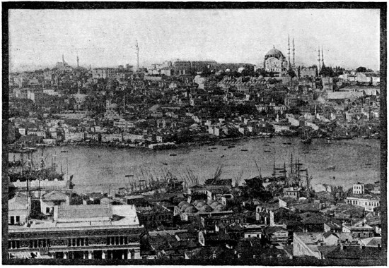
PANORAMA OF CONSTANTINOPLE
As the steamer runs up the Bosphorus, the white buildings and glittering minarets of Constantinople come into view; with the mosque of Santa Sophia, Galata Tower and Pera, the Sultan’s Palaces at Beshiktash, with Scutari Suburb on the right, and then, rounding Seraglio Point, it glides at half speed into the Golden Horn, or harbor of Constantinople. At this moment, if the weather be fine and clear, a striking panorama opens to the eye of the voyager. The Golden Horn divides the city into two sections; Stamboul to the left, and Galata and Pera to the right. It is a bay, or amphitheater, surrounded by hills which are covered with buildings, domes, minarets, and palaces, embosomed by cypress groves, with hundreds of vessels and caiques skimming in all directions.
Next, but not less beautiful, is the Suleymaniya, the mosque which the Great Suleyman and his architect Sinan erected on the model of St. Sophia, but with Saracenic ornament and a loftier though not quite so expansive dome. Some of the monolithic columns are remarkable for their size and beauty, and the general effect is even more imposing than that of St. Sophia.
Scarcely less stately is the Mosque of Sultan Ahmed I. in the Hippodrome; distinguished without by its six minarets (instead of the usual four), and within by the four gigantic columns which support the dome. Here the official celebrations and formal processions take place at the great festivals.
The mosque of the conqueror, Mohammed II., is also notable, though it has been greatly altered in restoration.
There are altogether some eight hundred mosques in Constantinople, and numerous chapels; but very few of them present features of special interest, except sometimes in the beauty of their wall tiles, of the Rhodian style, for the manufacture of which the suburb of Eyyûb was famous.
The remains of the Greek churches are more interesting, and the Fanar, or Greek quarter of Stambol, recall the memories of many distinguished Fanariote statesmen; but among the relics of ancient Constantinople none is more striking than the Hippodrome or “Horse Manège”, originally a circus surrounded by marble seats, long since removed, but still showing remains of antiquity, such as the famous column of the Three Serpents which once stood at the Temple of Delphi, and supported a gold tripod made out of the spoils taken by the Greeks at the battle of Platæa, but was removed to his new capital by Constantine.