BOOK OF THE EARTH (continued 2)
Reading edition
WONDERFUL GEYSERS OF THE YELLOWSTONE
The geysers of the Yellowstone region are probably the most picturesque and wonderful in the world. On the Firehole River alone there are probably fifty geysers, throwing columns of water to a height of from fifty to two hundred feet, while smaller jets rise occasionally to two hundred and fifty feet. The “Old Faithful” geyser, in this region, throws up a column of water six feet in diameter to a height of one hundred to one hundred and fifty feet, at intervals of about an hour. Near the north entrance to the National Park, also, are the hot springs of the Gardiner River; here the “White Mountain,” built up of terraces of white calcareous deposits, rises to a considerable height, with a diameter of one hundred and fifty yards at the top.
The geysers of Iceland are situated within sight of Mount Hekla and are the hottest springs in Europe. The principal geysers of this region are known as the “Great Geyser” or “Roarer,” and the “Stroker” or “Churn.”
The geysers of New Zealand attained celebrity chiefly on account of the beautiful terraces associated with them. Unfortunately, volcanic activity manifested itself throughout the region in 1886, resulting in the destruction of the terraces. The basins connected with these geysers, catching the overflow of water, are, like those of Yellowstone region, largely used by bathers, and are much resorted to by invalids.
The three localities mentioned are where geysers attain their highest development; but they also exist in many volcanic regions notably in Japan, South America, and the Malay Archipelago.
HOW THE EVER-MOVING WATERS OF THE EARTH GO ON THEIR MIRACULOUS JOURNEY FOREVER
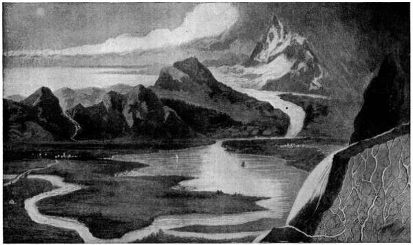
The circulation of the waters of the earth is just as marvellous as that of the blood in the human body. First, it is drawn up from the sea by the sun and rises as vapor; the cool air condenses it first into cloud and then rain or snow; it runs together, forming springs and waterfalls and rivers; and finally it finds its way to the sea, where again the never-ending journey begins.
THE WATERS OF THE EARTH
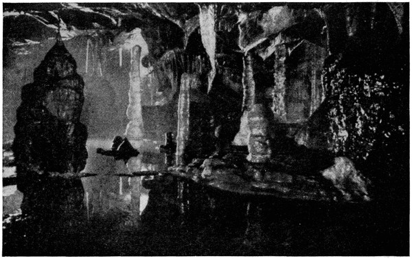
THE WATERS UNDER THE EARTH
The underground lake in its magnificent setting of dazzling stone columns and stalactites in the Cheddar Caves, England. All these wonderful natural halls, chasms and snowy incrustations were formed by the age-long action of the water on the limestone rocks through which it filtered.
Water is found in Nature in three states or conditions—as ice, vapor or steam, and as simple water. These three forms have the same chemical composition—the substance being a compound of oxygen and hydrogen, represented by the formula H2O; but the physical condition depends entirely on its temperature. Under ordinary atmospheric conditions water is a solid below 32 degrees Fahrenheit; a gas above 212 degrees Fahrenheit, and a liquid between these temperatures.
The purest form of water which exists in nature is rain water, though this always contains a little oxygen and carbon dioxide dissolved from the air. To obtain pure water artificially, any ordinary water is distilled, when all the solids dissolved in it are left behind. River water and spring water always contain a small quantity of solid matter, the amount and nature of the dissolved solids depending on the nature of the rocks over which the water has flowed.
Geographically it may be considered under the four heads of springs, rivers, lakes, and the ocean, which taken together forms the hydrosphere of the earth.
WHERE SPRINGS HAVE THEIR SOURCE
Springs, or the natural fountains of water, take their rise from reservoirs stored under ground. Water maintains a level, and hence the height to which a spring will rise depends on that of the level from which it is supplied. If the internal reservoir be on a hill, and the spring should gush out in a valley, the water may rise to a considerable height and form a natural fountain; but, on the other hand, if the reservoir be at some depth below the surface, the water may never reach the surface, and mechanical aid may be required to obtain it.
These internal reservoirs are in a great measure supplied by moisture derived from rain, snow, mist, and dew. The atmospheric water enters the earth through porous rocks, or by means of fissures, and continues to sink until arrested in its progress by rocks, such as clay, which will not permit the water to pass, or by faults which check it from spreading. The waters will then gush forth as a spring, of greater or less size, according to the supplies it may have received.
HOW MINERAL SPRINGS ARE FORMED
All springs contain a certain portion of air and gas, and also some solid matter, usually in the form of salts. When these salts are abundant, mineral springs are the result, which may be classified according to the character of their several properties, as acidulous, chalybeate, sulphurous, saline, calcareous, and silicious.
Acidulous or acid springs are those surcharged with carbonic acid gas.
Chalybeate springs are those in which iron, in the form of carbonate or sulphate, is held in solution.
Sulphur, in the form of sulphureted hydrogen or sulphate of lime, is the distinguishing ingredient in Sulphurous springs.
Saline springs are of two kinds—brine and medicinal; brine when containing a greater or less amount of chloride of sodium or common salt, and medicinal when containing other salts, as sulphate of soda, etc.
Calcareous springs are those highly charged with the salts of lime, and which have the property of petrifying substances placed within their reach, and also of depositing their contents, forming the stalactites and stalagmites of caverns, etc.
Silicious springs are so called from holding silica or flint in solution. The last-named are all hot or thermal as well as mineral springs, deriving their heat either from the natural heat of the earth at great depths, or from volcanic action. When occurring near volcanoes, they are frequently charged with bitumen, petroleum, naptha, asphaltum, etc.
WHY WATER FLOWS FROM ARTESIAN WELLS
An important class of artificial springs or wells is known as Artesian Wells. Where bent pervious beds of rock lie between two bent impervious beds, so as to make a basin-shaped depression, lower in the middle than at the edges, the rain which sinks into the pervious rock where it reaches the surface will begin to gather in the central part of the porous rock as in a reservoir.
If a hole be now bored in the hollow of the upper impervious bed till it reaches the water-bearing stratum, the water will flow out at the top. The water thus obtained may have fallen a distance of many miles several months previously, and if the gathering-ground be high the issue at the well may be forced by the pressure of the water behind to a considerable height.
FORMATION, CHARACTERISTICS AND PECULIARITIES OF RIVERS
Rivers have their sources from springs or from the melting of accumulations of snow. They do not, however, receive their largest supplies from the actual summits of mountains, for copious springs are rarely met with in such situations, nor are glaciers formed on the highest points of mountains, but more usually on slopes of the upper mountain valleys. It is, accordingly, in the latter localities that many of the largest rivers take their rise.
Watershed. It not unfrequently happens that several rivers take their rise in one mountain ridge, some flowing in one direction, and others taking an opposite course. Such a ridge is termed a watershed. Thus the Rhine, the Rhone, and the Danube all take their rise in the Alps, the first discharging itself into the North Sea, the second into the Mediterranean Sea, and the last into the Black Sea.
Basin. The portion of country drained by a river and its tributary streams is called its basin, from its catching the rains which fall within its circuit, and which the river carries to the sea. The largest river-basin in Europe is that of the Volga, in Asia, that of the Ganges, in Africa that of the Nile, in North America that of the Mississippi, and in South America that of the Amazon.
THE GREAT RIVERS OF THE WORLD
RIVER Length in Miles Emptying Into Area of Drainage in Square Miles, etc.
Mississippi-Missouri (United States) 4,330 Gulf of Mexico 1,245,000
Nile (Egypt) 3,500 Mediterranean 1,050,000
Amazon (Brazil): the only large river with direct latitudinal course 3,300 At Ocean on the Equator 2,700,000
Yangtze-Kiang (China) 3,000 Yellow Sea 548,000
Congo (Central Africa) 2,900 Atlantic Ocean 1,430,000
Lena (Russia in Asia) 2,800 Arctic Ocean 856,000
Amur (Russia in Asia) 2,800 Gulf of Saghalin 772,000
Mekong (Indo-China) 2,800 China Sea Nav. 200 miles
Yenisei (Russia in Asia) 2,700 Bay of Yenisei 1,000,000
Niger (West Africa) 2,600 Atlantic Ocean 808,000
Hoangho (China) 2,500 Gulf of Pe-Chi-Li 376,400
Obi (Russia in Asia) 2,300 Gulf of Obi 1,125,000
Plata-Parana (Argentina and Brazil) 2,300 Atlantic Ocean 2,300,000
Mackenzie (Canada) 2,300 Arctic Ocean 676,000
Volga (Russia in Europe) 2,200 Caspian Sea 560,000
St. Lawrence (United States and Canada) 2,200 Gulf of St. Lawrence 500,000
Yukon (Alaska) 2,200 Behring Sea 500,000
Indus (India) 2,000 Arabian Sea 373,000
Sao Francisco (Brazil) 1,800 Atlantic Ocean 249,000
Sir Daria (Turkestan) 1,800 Sea of Aral 175,000
Brahmaputra or Burrampooter (India) 1,800 Bay of Bengal Nav. 800 miles
Rio Grande del Norte (U. S. and Mexico) 1,800 Gulf of Mexico 240,000
Danube (Austria-Hungary) 1,780 Black Sea 311,000
Saskatchewan-Nelson (Canada) 1,732 Hudson Bay 730,000
Euphrates (Turkey in Asia) 1,700 Persian Gulf 260,000
Zambesi (East Africa) 1,600 Indian Ocean 800,000
Ural (Russia in Europe) 1,500 Caspian Sea 85,000
Arkansas (United States) 1,500 Mississippi River 181,000
Orinoco (Colombia and Venezuela) 1,500 Atlantic Ocean 364,000
Ganges (India) 1,500 Bay of Bengal 409,000
Amu (Turkestan) 1,400 Sea of Aral 174,000
Columbia (United States) 1,400 Pacific Ocean 260,000
Dnieper (Russia in Europe) 1,400 Black Sea 203,000
Murray (Australia) 1,400 Indian Ocean 351,000
Don (Russia in Europe) 1,300 Sea of Azov 166,000
Orange (S. W. Africa) 1,200 Atlantic Ocean 370,000
Irawaddy (East India) 1,200 Indian Ocean Nav. 800 miles
Colorado (United States) 1,100 Gulf of California 250,000
Senegal (West Africa) 1,100 Atlantic Ocean 270,000
Tigris (Turkey in Asia) 1,000 Euphrates and Persian Gulf Nav. generally for small boats
Ohio (United States) 970 Mississippi River 201,000
Churchill (Canada) 900 Hudson Bay Nav. by canoes
Magdalena (Colombia) 840 Caribbean Sea Nav. 600 miles
Rhine (Germany) 800 North Sea 76,000
Cambia (West Africa) 750 Atlantic Ocean Nav. 300 miles
Elbe (Germany) 720 North Sea 57,000
Fraser (British Columbia) 650 Gulf of Georgia Nav. generally for small boats
Vistula (Germany, Poland) 600 Baltic Sea 120,000
Sacramento (United States) 600 Pacific Ocean Nav. 300 miles
Tagus (Portugal) 570 Atlantic Ocean 32,000
Paranahiba (Brazil) 530 Atlantic Ocean Nav. 400 miles
Guadiana (Spain) 510 Mediterranean Sea 32,000
Rhone (France) 500 Gulf of Lyons 38,000
Seine (France) 480 English Channel 30,000
Ebro (Spain) 470 Mediterranean Sea 32,000
Susquehanna (United States) 450 Chesapeake Bay Not navigable
Potomac (United States) 450 Chesapeake Bay Nav. to Washington, D. C.
Oder (Germany) 440 Baltic Sea 43,000
Po (Italy) 420 Adriatic Sea 29,000
Garonne (France) 380 Bay of Biscay 33,000
Hudson (United States) 350 New York Bay Nav. to Troy; 150 miles
Loire (France) 200 Bay of Biscay 25,000
Thames (England) 200 North Sea 5,250
Deltas and Estuaries. Owing to local peculiarities at the mouths of rivers, accumulations of sedimentary matter take place in the middle of the stream, dividing it into two or more branches. By these depositions deltas (so called from the Greek letter (Δ) delta) are formed—many of them, as those of the Mississippi and Orinoco and of the Rhine and the Ganges, being of great extent. Some rivers fall into the ocean through estuaries or wide channels, and are subject to a great swell or sudden rise of the waters when the tide enters.
PICTURE DIAGRAM GIVING A COMPARATIVE VIEW OF THE WORLD’S FAMOUS RIVERS AND MOUNTAINS
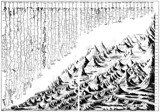
FIRST: Showing the comparative length of the rivers; where and how they take their rise; where and how they empty; their chief branches and connected lakes; and the principal cities located on their banks.
SECOND: Comparative height of mountains, arranged in groups by continents, showing the relative height of both mountains and continents. See next page for LOCATION and HEIGHT IN FEET of the various mountain peaks.
Large illustrations: Rivers (left-hand side) (480 kB) Rivers (right-hand side) (137 kB) Moutains (left-hand side) (187 kB) Moutains (right-hand side) (554 kB)
Most rivers are subject to an occasional, and in some instances to a periodical increase of volume. These seasons of flood are by no means regular, being partly dependent on the melting of the snows, and partly on occasional heavy falls of rain; and hence depend on the climatic variations of the country in which rivers originate.
FAMOUS MOUNTAIN AND OTHER ELEVATIONS OF THE WORLD
Note: The numbers refer back to the Picture Diagrams on the preceding page.
Ref. No. Name and Location Height in Feet
NORTH AMERICA
A. * Mount McKinley, Coast Range, Alaska 20,300
1. Orizaba, Cordillera, Mexico 18,310
2. Mount St. Elias, Coast Range, Alaska 18,024
3. Popocatapetl, Cordillera, Mexico 17,748
4. Mount Brown, Rocky Mountains, Canada 15,990
5. Mount Hooker, Rocky Mountains, Canada 15,700
6. Mount Fairweather, Coast Range, Alaska 14,750
7. * Mount Rainier, Coast Range, Washington 14,408
8. * Mount Whitney, Coast Range, California 14,501
9. Mount Elbert, Rocky Mountains, Colorado 14,402
10. Pike’s Peak, Rocky Mountains, Colorado 14,108
11. * Gannett Peak, Rocky Mountains, Wyoming 13,785
12. Fremont’s Peak, Rocky Mountains, Wyoming 13,570
13. * Kings Peak, Utah 13,498
14. * N. Truchas Peak, Rocky Mountains, New Mexico 13,306
15. * E. Peak, White Mountains, Nevada 13,145
16. * Granite Peak, Rocky Mountains, Montana 12,850
17. * San Francisco Peak, Arizona 12,611
18. Mount Assiniboine, Rocky Mts., Canada 11,860
19. * Mount Hood, Coast Range, Oregon 11,225
20. * El Capitan, Texas 9,020
21. Mount Potrillo, Cuba 9,000
22. Cibao Mountains, Hayti, West Indies 8,970
23. * Harvey Peak, South Dakota 7,242
24. Sierra del Cobre, Cuba 7,200
25. * Mount Mitchell, Allegheny Mts., N. C. 6,711
26. * Mount Guyot, Allegheny Mts., Tennessee 6,636
27. Black Mountain, Allegheny Mts., N. C. 6,476
28. * Mount Washington, White Mts., N. H. 6,293
29. Roan Mountain, Allegheny Mts., N. C. 6,038
30. Mount Adams, White Mts., N. H. 5,963
31. Mount Jefferson, White Mts., N. H. 5,725
32. * Mount Rogers, Blue Ridge, Virginia 5,719
33. Mount Monroe, White Mts., N. H. 5,390
34. * Banner Peak, Nebraska 5,350
35. * Mount Marcy, Adirondacks, New York 5,344
36. * Mount Katahdin, Maine 5,273
37. Mount McIntyre, Adirondacks, New York 5,112
38. Mount Hecla, Iceland 5,110
39. Mount Franklin, White Mts., N. H. 5,050
40. Skylight, Adirondacks, New York 4,920
41. Haystack, Adirondacks, New York 4,918
42. Morne Garon, St. Vincent, West Indies 4,800
43. * Spruce Knob, West Virginia 4,860
44. * Brasstown Bald, Georgia 4,768
45. * Cimarron Peak, Oklahoma 4,750
46. Mount Lafayette, White Mts., N. H. 4,723
47. Mount Morris, Adirondacks, New York 4,576
48. Mount Pelée, Martinique 4,300
49. * Mount Mansfield, Green Mts., Vermont 4,364
50. Otter Peak, Allegheny Mountains, Virginia 4,260
51. * Highlands (West Boundary), Kansas 4,135
52. * Big Black Mountain, Kentucky 4,100
53. Killington, Green Mountains, Vermont 4,100
54. Mount Seward, Adirondacks, New York 4,000
55. Table Mountain, Allegheny Mts., Virginia 4,000
56. * Bald Mountain, Allegheny Mts., Virginia 4,000
57. Mount Parnassus, Spitzbergen 3,951
58. Round Top, Catskills, New York 3,804
59. High Peak, Catskills, New York 3,718
60. Mount Misery, St. Christopher, West Indies 3,712
61. Sierra de Luquillo, Porto Rico 3,678
62. Mount Greylock, Taconic Mts., Mass. 3,505
63. * Monadnock, White Mts., New Hampshire 3,450
64. * Bowman Summit 3,500
65. Backbone Mountain, Maryland 3,340
66. * Blue Knob, Allegheny Mts., Pennsylvania 3,136
67. Central Peak, Nevis, West Indies 3,000
68. * Blue Mountain, Arkansas 2,800
69. Kearsarge, White Mts., New Hampshire 2,460
70. * Cheaha Mountain, Alabama 2,407
71. * Bear Mountain, Connecticut 2,355
72. * Rib Hill, Wisconsin 1,940
73. * Mesabi Range Minnesota 1,920
74. High Point, New Jersey 1,809
75. Pringhar, Iowa 1,800
76. Taun Sauk Mountain, Ozarks, Missouri 1,750
77. * Logan Summit, Ohio 1,550
78. West Point, Highlands, New York 1,500
79. Storm King, Highlands, New York 1,389
80. * Charles Mound, Illinois 1,241
81. Carlos Summit, Indiana 1,210
82. Mount Tom, Massachusetts 1,200
83. Berkshire Hills, Massachusetts 1,200
84. Anthony’s Nose, Highlands, New York 1,048
85. Mount Holyoke, Massachusetts 830
86. Palisades of Hudson, New York and N. J. 500
87. Mount Hope, Rhode Island 300
88. Bunker Hill, Massachusetts 62
* Greatest altitude in the state or territory.
EUROPE
1. Monte Blanc, France 15,782
2. Monte Rosa, Italy 15,217
3. Weisshorn, Switzerland 14,808
4. Matterhorn, or Cervin, Switzerland 14,780
5. Finsteraarhorn, Switzerland 14,026
6. Breithorn, Switzerland 13,685
7. Jungfrau, Switzerland 13,671
8. Mönch, Switzerland 13,465
9. Pic des Ecrins, France 13,462
10. Shreckhorn, Switzerland 13,385
11. Mount Paradis, France 13,300
12. Otherspitze, Austria 12,800
13. Gross Glockner, Austria 12,776
14. Aiguille du Midi, France 12,743
15. Monte Viso, France 12,582
16. The Gallonstock, Switzerland 12,481
17. Aiguille de Sassire, Sardinia 12,346
18. Wetterhorn, Switzerland 12,150
19. Mont Genevre, Sardinia 11,785
20. Monto Gavio, Austria 11,754
21. Cerro de Mulhacen, Spain 11,605
22. Simplon, Switzerland 11,541
23. Wisbach Horn, Austria 11,518
24. La Mormelata, Austria 11,508
25. Mont Cenis, France 11,457
26. Mont Nethou, Spain 11,427
27. Pic Blanc, France 11,190
28. Great St. Bernard, Switzerland 11,080
29. Vignemale, France and Spain 10,980
30. St. Gothard, Switzerland 10,595
31. Mount Calm, France and Spain 10,500
32. Pic Blanc, France and Spain 10,205
33. Splugen, Switzerland and Austria 9,981
34. Peak of Oo, France and Spain 9,730
35. Pic du Midi, France 9,650
36. Mount Etna, Island of Sicily 9,652
37. The Thorstein, Austria 9,630
38. Little St. Bernard, France 9,591
39. Monte Corno, Italy 9,523
40. Canigon, France 9,137
41. Monte Rotondo, Island of Corsica 9,065
42. Guiona, Greece 8,620
43. Lomnitzer Spitze, Austria 8,779
44. Rilo Dagh, Bulgaria 8,300
45. Mount Parnassus, Greece 8,000
46. Mount St. Elias, Greece 7,946
47. Mount Ida, Crete 7,674
48. Col de Ferret, Switzerland 7,641
49. Mount Dinara, Austria-Hungary 7,458
50. Monte Cimone, Italy 7,083
51. Mount Kleck, Austria-Hungary 6,926
52. Pisanino, Italy 6,723
53. Pizzo di Casi, Sicily 6,509
54. Oraefa Yokul, Iceland 6,420
55. Kissovo, Bulgaria 6,407
56. Genargentu Peak, Sardinia Island 6,290
57. Mount D’or, France 6,188
58. Mount Pierus, Bulgaria 6,161
59. P. de Cantal, France 6,093
60. Sulitelma, Sweden and Norway 5,956
61. Monte Amiata, Tuscany 5,792
62. Recullet de Toiry, Switzerland 5,643
63. La Dole, Switzerland 5,509
64. Black Mountain, Island of Cephalonia, Greece 5,356
65. Zagora, Bulgaria 5,310
66. St. Angelo, Lipari Island, Sicily 5,260
67. Schneekoppe, Germany 5,253
68. Feugari, Samothraki Island, Turkey 5,248
69. Feldberg, Black Forest, Germany 4,900
70. Puy de Dome, France 4,846
71. Ballon de Alsace, France 4,688
72. Monte Alto, Italy 4,380
73. Hohenstein, Austria 4,284
74. Brokfeld, Norway 4,188
75. Mount Delphi, Island of Negropont, Greece 4,156
76. Kielburg, Erz Gebirge, Germany 4,074
77. Montserrat, Spain 4,054
78. Vesuvius, Italy 4,260
79. Brocken, Harz Mountains, Germany 3,740
80. Ispario, Thasos Island, Greece 3,428
81. Great Beerberg, Thuringerwald, Germany 3,265
82. Summit, Norway 3,200
83. Great Feldsberg, Germany 2,886
84. Stromboli, Lipari Island, Sicily 3,090
85. Mount Delphi, Skopela Island, Greece 2,295
86. Tonnere, France 2,225
87. Mount St. Oreste, Italy 2,140
88. Peak, Island of Corfu, Greece 1,900
89. Kastri, Island of Thasos, Greece 1,565
90. Gibraltar, Spain 1,437
91. Valdai Hills, Russia 1,200
92. North Cape, Island of Mageroe, Norway 1,161
93. Himmelsberg, Plateau of Denmark, Denmark 928
94. Montmartre, Paris, France 400
95. Observatory, Paris, France 240
96. Heligoland Island, North Sea, Germany 230
BRITISH ISLES
1. Greenwich Observatory, Kent, England 214
2. Holyhead, Island of Anglesea, Wales 709
3. Carraton, Cornwall, England 1,208
4. Penmaen Maur, Wales 1,540
5. Axedge, Derby, England 1,750
6. Pendlehill, Lancashire, England 1,803
7. Holmernoss, Derby, England 1,859
8. Ingleborough, Yorkshire, England 2,361
9. Whernside, Yorkshire, England 2,384
10. Plinlimmon, Cardiganshire, Wales 2,463
11. Cradle Mountain, Brecknockshire, Wales 2,545
12. Coniston Fell, Westmoreland, England 2,577
13. Caermarthen Vau, Caermarthenshire, Wales 2,596
14. Cheviot, Northumberland, England 2,684
15. Grassmere Fell, Cumberland, England 2,756
16. Cross Fell, Cumberland, England 2,909
17. Bow Fell, Cumberland, England 2,911
18. Cader Idris, Merionethshire, Wales 2,914
19. Arran Mowdwy, Merionethshire, Wales 2,955
20. Skiddaw, Cumberland, England 3,022
21. Helvellyn, Cumberland, England 3,313
22. Carnedd Llewellyn, Caernarvon, Wales 3,471
23. Snowdon, Caernarvon, Wales 3,571
24. Cairn Gorm, Invernesshire, Scotland 4,095
25. Ben Macdui, Aberdeenshire, Scotland 4,305
26. Ben Nevis, Inverness, Scotland 4,368
27. Cairntoul, Aberdeenshire, Scotland 4,245
28. Ben Lawers, Perthshire, Scotland 3,945
29. Ben More, Perthshire, Scotland 2,944
30. Ben Gloe, Perthshire, Scotland 3,690
31. Ben Cruachan, Argyleshire, Scotland 3,669
32. Ben Deirg, Perthshire, Scotland 3,550
33. Schehallien, Perthshire, Scotland 3,514
34. Macgillicuddy Reeks, Kerry, Ireland 3,404
35. Scarscoch, Aberdeenshire, Scotland 3,402
36. Ben Gurdy, Perthshire, Scotland 3,364
37. Ben More, Sutherlandshire, Scotland 3,231
38. Ben Lomond, Stirlingshire, Scotland 3,180
39. Ben Voirlich, Perthshire, Scotland 3,055
40. Lunaquilla, Wicklow, Ireland 3,039
41. Galtee Mountains, Tipperary, Ireland 3,008
42. Slatterwind, Stromoe, Faroe Islands 2,998
43. Black Larg, Ayrshire, Scotland 2,890
44. Goat Fell, Island of Arran, Scotland 2,865
45. Ben Ledi, Perthshire, Scotland 2,863
46. The Cobbler, Argyleshire, Scotland 2,863
47. Slievedonard, Ulster, Ireland 2,796
48. Broad Law, Peeblesshire, Scotland 2,741
49. Ben Wyvis, Rosshire, Scotland 2,720
50. Hart Fell, Dunfriesshire, Scotland 2,635
51. Mount Battock, Kincardineshire, Scotland 2,600
52. Lowther Hill, Lanarkshire, Scotland 2,522
53. Kippure, Leinster, Ireland 2,473
54. Paps of Jura, Argyleshire, Scotland 2,470
55. Slievenaman, Tipperary, Ireland 2,362
56. The Paps, Kerry, Ireland 2,280
57. Snaefell, Isle of Man, Great Britain 2,004
58. Campsie Hills, Stirlingshire, Scotland 1,850
59. Achil Head, Mayo, Ireland 1,800
60. Pentland Hills, Scotland 1,700
61. Peak, Hoy Island, Orkney Group 1,569
62. Eildon Hills, Roxburgshire, Scotland 1,364
63. Ailsa Craig, Firth of Clyde, Scotland 1,139
64. Dunnose, Isle of Wight, England 792
65. Salisbury Craigs, Mid Lothian, Scotland 550
66. Hill of Howth, Dublin, Ireland 549
67. Edinburg Castle, Mid Lothian, Scotland 434
68. Bass Rock, Firth of Forth, Scotland 400
69. St. Paul’s, London, England 404
ASIA AND PACIFIC ISLANDS
A. Mount Everest, India-China 29,002
1. Godwin-Austin, India-China 28,278
2. Dapsang, Tibet 28,273
3. Kanchanjanga, India-China 28,156
4. Nanga-Parbat, India 26,629
5. Dhawalaghiri, India 26,286
6. Nanda-Devi, India 25,661
7. Bride Peak, India 25,100
8. Chumolhari, India 23,933
9. Kaufmann, Turkestan 23,000
10. Cantas, India-China 22,500
11. St. Patrick, India-China 22,385
12. St. George, India-China 22,240
13. Gemini, India-China 21,600
14. Bunderpooch, India-China 21,155
15. Pyramid, India-China 20,966
16. Peak, Hindu Kush, Afghanistan 20,230
17. Bunderpooch 2d, India 20,122
18. Mount Elburz, Russian Empire 18,526
19. Mount Ararat, Asia Minor 17,160
20. Mount Kasbeck, Russian Empire 16,592
21. Kliontsheoskoi, Kamtschatka 16,512
22. Kassoumba, Sumatra, Malaysia 15,000
23. Australian Alps, Australia 15,000
24. Demavend, Persia 18,500
25. Mouna Kea, Hawaii, Hawaiian Islands 13,953
26. Mount Ophir, Sumatra, Malaysia 13,842
27. Mouna Loa, Hawaii, Hawaiian Islands 13,600
28. Arjish Dagh, Asia Minor 13,100
29. Sevellan, Persia 13,000
30. Gunong Dempu, Sumatra, Malaysia 12,465
A. Mount Erebus, Victoria Land, Antarctic Continent 12,400
31. Peak, Formosa, Japan 12,000
B. Mount Terror, Victoria Land, Antarctic Continent 11,500
32. Koriatskaia, Kamtschatka 11,215
33. Mount Lebanon, Syria 11,050
34. Mount Bielucha, Russian Empire 11,063
35. Peak, Otaheite, Polynesia 10,895
36. Italitskui, Russian Empire 10,735
37. Kriontskaia, Kamtschatka 10,625
38. Shivelutsh, Kamtschatka 10,591
39. Haleakala, Maui, Hawaiian Islands 10,200
40. Murtchurti Bet, India 10,070
41. Mount Olympus, Asia Minor 9,100
42. Mount Egmont, New Zealand 8,839
43. Arvatskaa, Kamtschatka 8,760
44. Dodabetta, India 8,760
45. Mount St. Catherine, Arabia 8,593
46. Mount Sinai, Arabia 8,300
47. Pedro-talla-galla, Ceylon 8,326
48. Melin, China 8,200
49. Kirrigal Pota, Ceylon 7,810
50. Totta Rella, Ceylon 7,720
51. Peak of Yeddo, Japan 7,680
52. Adams’ Peak, Ceylon 7,420
53. Mount Serbal, Arabia 6,760
54. Quelpaert, Quelpaert Island 6,400
55. Sea View Hill, Australia 6,300
56. Taddiamdamala, India 6,055
57. Subramain, India 5,560
58. Jebel, Akral, Arabia 5,318
59. Abu, India 5,100
60. Mount Ida, Asia Minor 4,960
61. Peak of Teneriffe, Tasmania 4,500
62. Mount Williams, Australia 4,500
63. Corean Mountains, Japan 4,480
64. Baskirian Urals, Russian Empire 4,400
65. Ben Lomond, Tasmania 4,200
66. Mount Wellington, Tasmania 3,795
67. Forest Hill Peak, Australia 3,776
68. Quamby’s Bluff, Tasmania 3,500
69. Karnalighur, India 3,203
70. Mount York, Australia 3,192
71. Mount Exmouth, Australia 3,000
72. Mount Cole, Australia 3,000
73. Mount Field, Tasmania 3,000
74. Peak, St. Paul’s Island, Indian Ocean 2,760
75. Sugar Loaf, Peak, Australia 2,527
76. St. Paul’s Dome, Tasmania 2,500
77. Mount Carmel, Palestine, Syria 2,250
78. Mount Tabor, Palestine, Syria 2,053
79. Bathurst Heights, Australia 1,970
AFRICA
1. Kilimanjaro, East Africa 19,780
2. Kibo Peak, German East Africa 19,320
3. Mount Kenia, British Africa 17,200
4. Mount Stanley, Central Africa 16,800
5. Abba Yared, Abyssinia 15,200
6. Bushad, Abyssinia, Central Africa 14,364
7. Mongo-ma-Lobah, Central Africa 13,760
8. Peak of Teneriffe, Canary Islands 12,000
9. Mount Miltsen, North Africa 11,400
10. Clarence Peak, Fernando Po Island, Gulf of Guinea 10,655
11. Pic Nieges, Bourbon Island, Indian Ocean 10,355
12. Spitz-Kop, South Africa 10,240
13. Mount Alantika, Central Africa 9,000
14. Tarami, Abyssinia 8,643
15. Peak, Tristan de’Acunha Island, Atlantic Ocean 8,236
16. Peak of Pico, Azores, Atlantic Ocean 7,013
17. Volcano Fogo, Cape de Verd Islands, Atlantic Ocean 7,884
18. El Cumbre, Canary Islands, Atlantic Ocean 6,648
19. Jebel Akhal, East Africa 6,500
20. Pico Ruivo, Madeira Island, Atlantic Ocean 6,056
21. Mount Dogen, Central Africa 5,000
22. Table Mountain, South Africa 3,582
23. Devil’s Peak, South Africa 3,315
24. Green Mountain, Ascension Island, Atlantic Ocean 2,868
25. Mount Tekut, North Africa 2,800
26. Diana’s Peak, St. Helena, Atlantic Ocean 2,692
27. Lion’s Head, South Africa 2,166
28. Cape, Cape Colony, South Africa 1,000
29. Pyramid of Cheops, Egypt 479
30. Pyramid of Chephren, Egypt 456
SOUTH AMERICA
1. Aconcagua, Chile 23,080
2. Sorata or Illampu, Bolivia 23,000
3. Mercedario, Argentina 22,312
4. Illimani, Bolivia 22,200
5. Tupungato, Chile 21,550
6. Condor, Argentina 21,128
7. Famatina, Argentina 20,680
8. Salcantay, Peru 20,540
9. Chimborazo, Ecuador 20,475
10. Antisana, Ecuador 19,184
11. Santa Morta, Colombia 19,030
12. Tacora, Bolivia 19,000
13. Cotopaxi, Ecuador 18,880
14. Arequipa, Peru 18,370
15. Tolima, Colombia 18,069
16. Maispo, Chile 17,670
17. Peak of Cuzco, Peru 17,525
18. Sangai, Ecuador 17,460
19. Ruiz, Colombia 17,388
20. Tunguraqua, Ecuador 16,690
21. Cotocachi, Ecuador 16,300
22. Cerro de Potosi, Bolivia 16,037
23. Pichincha, Ecuador 15,918
24. Roraima, Venezuela 8,740
25. Silla de Caracas, Venezuela 8,632
26. Duida, Venezuela 8,467
27. Corcorada, Argentina 7,510
28. Minchinmadiva, Argentina 7,046
29. Mount Sarmiento, Tierra del Fuego 7,000
30. Mount Darwin, Tierra del Fuego 6,800
31. Guadarrama, Colombia 6,400
32. Itambe, Brazil 5,960
33. Piedade, Brazil 5,820
34. Itacolumi, Brazil 5,750
35. Morro dos Canudos, Brazil 4,476
36. Macarapan, Guayana 3,500
37. Cape Horn, Argentina 1,870
FRESHWATER AND SALT LAKES
Lakes are of different kinds. Some are mere tanks which receive the first outpourings of springs, others consist of basins or reservoirs which occur in the line of a river’s course; some consist of basins or cavities, into which rivers flow, but which, on account of their depression or their mountainous cincture have no outlets; lakes are also formed in the craters of extinct volcanoes; and some lakes are periodic, or subject to have their basins alternately empty and full of water.
Mountain Lakes, which are valleys or chasms filled by streams, are long and narrow, rarely of extensive area, but often of great depth. Examples of this class are found in Lakes Champlain and George, among the Appalachian Mountains; Lakes Constance and Geneva, on the northern side of the Alps; and Lake Maggiore and Lake Como, on the south side; all of which are renowned for the loveliness of their shores, or the grandeur of the surrounding mountain scenery.
Lake Maggiore, which is hardly three miles wide, is, according to Italian engineers, 2,623 feet deep—more than double the depth of Lake Superior—its basin reaching 1,936 feet below the sea level.
The forms of mountain lakes are very irregular, for the water often covers several contiguous and connected valleys. This is the case in Lake Como, which has two long arms; and Lakes Lucerne and Lugano, each of which fills four distinct valleys, meeting one another nearly at right angles.
Lakes in Plains. The lake basins in plains and plateaus are, usually, simple depressions in a comparatively uniform surface. The lakes are, therefore, often of great size, broad in proportion to their length, but of little depth compared with their area.
The largest lakes of the globe—the Caspian and Aral seas, and the great North American and African lakes—and the largest in Europe and South America, all belong to this class. Their vast expanse, together with the tameness of their shores, deprives them of the picturesque beauty of mountain lakes.
Characteristics of Salt Lakes. Numerous lakes in the interior of the continents, though receiving affluents, have no outlet. Their waters are chiefly lost by evaporation, though some portion may be absorbed by the sandy soil.
The surfaces of the continents having been the beds of the primeval oceans, the presence of salt in the soil is a natural consequence.
Famous Salt Lakes. The Great Salt Lake of Utah, in the Great American Basin, is one of the finest examples of its class. The Caspian and Aral seas, at the bottom of the vast depression between Europe and Asia, are the most extensive salt lakes. The former has about four times the area of Lake Superior; and the latter is a little larger than Lake Michigan.
The Caspian, though receiving the Volga, the largest river of Europe, evaporates so much water that its surface is about 83 feet lower than that of the Mediterranean, varying with the seasons. Many lakes in its neighborhood disappear entirely in the heat and drought of summer, leaving their beds covered with a crust of pure white crystalline salt.
The Remarkable Dead Sea, in Syria, is a lake in which the salt has accumulated until the water is converted into a heavy brine. It may be the remnant of an ancient sea of much greater extent, which has been gradually reduced in size by the excess of evaporation over the supply of water in its basin.
This celebrated body of water lies in the deepest part of a long chasm or valley, which is sunk not less than 4,000 feet below the level of the surrounding country. The surface of the lake is 1,286 feet, and its bottom 2,500 feet, below the level of the Mediterranean.
Its feeder, the river Jordan, flows almost throughout its entire course below the level of the sea, the only known instance of the kind. The beautiful lake of Tiberias, the scene of so many of the miracles of Jesus, which is but an expansion of the Jordan in its upper course, is about 650 feet below the surface of the Mediterranean.
HOW THE LAKES ARE DISTRIBUTED OVER THE GLOBE
Lakes are most numerous in the central and northern portions of Asia, Europe and North America. The southern continents, except Africa, have comparatively few.
Asia is pre-eminently the continent of salt lakes. They occur in countless numbers, both in the steppes north of the Caspian and Aral, and in all the interior plateaus. Lakes of fresh water are also found among the Altai Mountains and adjacent chains. Lake Baikal, one of these, is the largest mountain lake known, being nearly 500 miles long.
Europe. The most characteristic and celebrated lakes are those which adorn the Alps of Switzerland and Scandinavia, and the less lofty mountain chains of the British Isles. But the largest lakes are found in the low lands and slight swells which surround the Baltic Sea, in western Russia and Sweden. Lakes Ladoga and Onega in Russia, and Wener and Wetter in Sweden, are the largest in Europe.
North America is peculiarly rich in great lakes. No continent presents a more remarkable series than that which stretches from northwest to southeast, through the central plains, along the line of contact of the oldest geological formations of the continent. This series includes Great Bear and Great Slave lakes, Athabasca and Winnipeg, and the five great lakes of the St. Lawrence, with many of less area.
Innumerable small lakes are scattered throughout the middle portions of the central plain, and the northern and less regular part of the Appalachian mountain region; but south of the parallel of Lake Erie there is an almost entire absence of lakes, whether large or small.
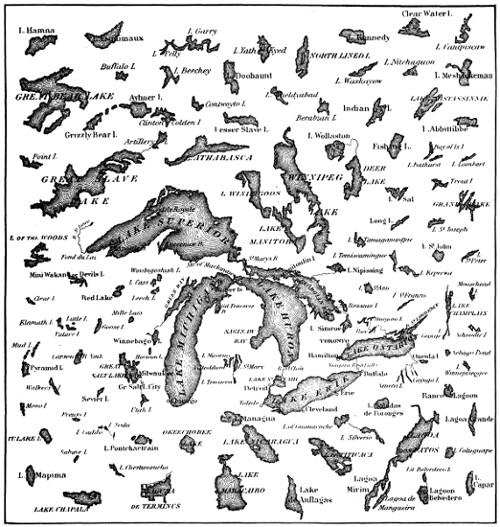
Relative Size of Lakes of the Western Hemisphere
Large illustration (397 kB)
PRINCIPAL SALT-WATER LAKES OF THE WORLD
NAME Location Area in Square Miles Mean Elevation in Feet
Black Sea Asia and Europe 170,000 Sea-level
Caspian Sea Asia 170,000 90 below sea-level
Sea of Aral Asia 26,160 157 above sea-level
Balkash Asia 7,135 779 above sea-level
Maracaibo South America 6,315 0 above sea-level
Eyre Australia 3,600 70 above sea-level
Titicaca (slightly saline) South America 3,200 12,506 above sea-level
Issik-kul Asia 2,250 5,300 above sea-level
Great Salt Lake North America 2,177 4,218 above sea-level
Koko-nor Asia 2,040 9,970 above sea-level
Urumiah Asia 1,795 4,100 above sea-level
Van Asia 1,400 5,200 above sea-level
Dead Sea Asia 444 1,290 below sea-level
Ngami (nearly dried up) Africa 297 2,919 above sea-level
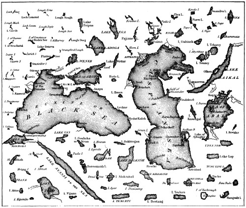
Relative Size of Lakes of the Eastern Hemisphere
Large illustration (371 kB)
PRINCIPAL FRESH-WATER LAKES OF THE WORLD
NAME Location Area in Square Miles Mean Elevation in Feet
Superior North America 31,200 601 above sea-level
Victoria Nyanza Africa 26,500 3,300 above sea-level
Huron North America 23,800 581 above sea-level
Michigan North America 22,450 581 above sea-level
Baikal Asia 13,200 1,542 above sea-level
Tanganyika Africa 12,000 2,756 above sea-level
Great Bear North America 11,200 391 above sea-level
Nyassa Africa 10,230 1,706 above sea-level
Great Slave North America 10,200 520 above sea-level
Erie North America 9,960 573 above sea-level
Winnipeg North America 9,400 710 above sea-level
Lake of the Woods North America 7,650 1,060 above sea-level
Ontario North America 7,240 247 above sea-level
Ladoga Europe 6,998 49 above sea-level
Tchad Africa 6,000 to 40,000 1,150 above sea-level
Athabasca North America 4,400 690 above sea-level
Onega Europe 3,760 237 above sea-level
Nicaragua Central America 2,972 131 above sea-level
Wener Europe 2,400 147 above sea-level
Albert Nyanza Africa 1,730 2,230 above sea-level
Dembea Africa 1,000 6,100 above sea-level
Wetter Europe 936 288 above sea-level
Champlain North America 750 96 above sea-level
Managua North America 560 154 above sea-level
Bangweolo Africa 400 to 5,800 3,690 above sea-level
St. Clair North America 396 576 above sea-level
Balaton (Platten See) Europe 266 426 above sea-level
Geneva (or Leman) Europe 214 1,220 above sea-level
Constance (or Boden See) Europe 208 1,308 above sea-level
Garda Europe 136 213 above sea-level
Neuchatel Europe 90 1,424 above sea-level
Maggiore Europe 78 646 above sea-level
Cayuga North America 76 381 above sea-level
George North America 61 323 above sea-level
Como Europe 56 649 above sea-level
Lucerne Europe 40 1,435 above sea-level
Zurich Europe 37 1⁄2 1,340 above sea-level
Africa. The great plateau lakes are typical of the continent. The Victoria Nyanza and Albert Nyanza, feeding the White Nile; Tanganyika, whose outlet is unknown; Tzana, at the head of the Blue Nile; and Lake Nyassa, in the Zambezi basin, all rest on the high plateaus of Central Africa. Lake Tchad alone, among large African lakes, is surrounded by low plains.
Waterfalls and Rapids. The variations in the slope of a river-bed, arising from unequal erosion, or from the original irregularities in the surface, give rise to rapids and falls.
The first occur where an increased slope causes the stream to flow with more than its average velocity. The second are caused by nearly perpendicular rocky walls, down which the foaming water descends in picturesque cascades, or imposing cataracts.
The famous “Cataracts of the Nile” are merely rapids which impede but do not entirely obstruct, the navigation as cataracts must. The so-called Falls of St. Anthony, in the upper Mississippi, and the rapids of the St. Lawrence, above Montreal, are among the finest rapids in American rivers.
The highest falls are in the upper course of rivers, in mountainous regions; the greatest and most imposing, in their middle course.
The Niagara Falls exhibit a most important industrial utilization of water power. The Falls of St. Anthony in the Mississippi, the Falls of Foyers in Scotland, the Rhine falls, the Rhone falls of Bellegarde, and the innumerable waterfalls of Scandinavia, Switzerland, and similar mountainous lands, are all utilized in this way. It has been proposed to convey power generated at the Victoria falls of the Zambezi to the Rand goldfield of the Transvaal, and a scheme for this is now being prepared.
FAMOUS WATERFALLS OF THE WORLD
Name Location Height (feet)
Bridal Veil California 900
Foyers Great Britain 205
Gastein Falls Austria 469
Gavarnie Pyrenees 1,400
Genesee New York 95
Grand Falls Labrador 2,000
Great Falls Montana 500
Hay River Alaska 200
Kaieteur Falls Guiana 740
Krimmler Falls Austria 1,300
Kukenam Fall Guiana 1,500
Maanelvan Norway 940
Minnehaha Minnesota 50
Missouri Montana 90
Montmorenci Quebec 265
Multnomah Oregon 850
Murchison Africa 120
Nevada Falls California 600
Niagara New York 165
Oroco Falls Monte Rosa 2,400
Rjukanfos Norway 804
Roraima Fall Guiana 2,000
Rukaufos Norway 513
St. Anthony Minnesota 80
Schaffhausen Switzerland 100
Seven Falls Colorado 266
Shoshone Idaho 210
Skykjefos Norway 700
Snoqualmie Washington 268
Staubbach Switzerland 1,000
Stirling New Zealand 500
Sutherland New Zealand 1,904
Takkakaw British Columbia 1,200
Tequendama Colombia 475
Tessa Falls Austria 541
Twin Idaho 180
Velino Falls Italy 591
Vermafos Norway 984
Vettisfos Norway 950
Victoria Falls Zambezi 400
Voringsfos Norway 600
Yellowstone (upper) Montana 110
Yellowstone (lower) Montana 310
Yguazu or Iguazu Brazil 210
Yosemite (upper) California 1,436
Yosemite (middle) California 626
Yosemite (lower) California 400
FAMOUS WATER PICTURES OF THE NEW AND OLD WORLD
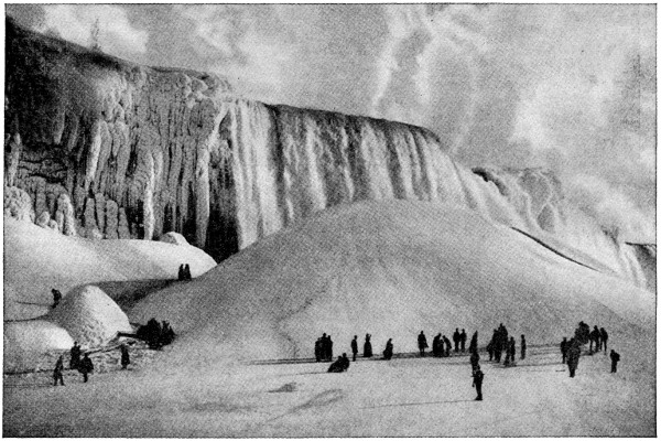
Niagara in winter presents a picture of frozen grandeur equaled nowhere else in the world.
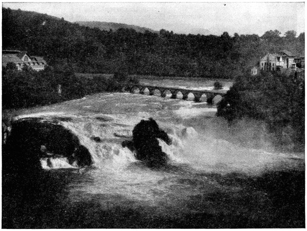
The Rhine at Schaffhausen, Switzerland, rushes over rugged rocks on its way down from the highlands into the lovely and historic valley it has carved for itself on its way to the sea.
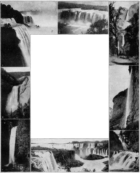
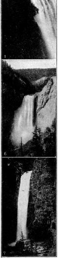
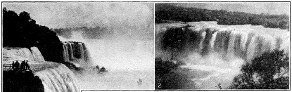

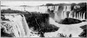
FAR-FAMED WATERFALLS THAT HAVE INSPIRED TRAVELERS AND WRITERS
1. The Niagara Falls and rapids form one of the most impressive spectacles in the world. The Niagara River, which is the sole outlet of the great lakes, pours itself in two vast sheets over a precipice about 160 feet high. Goat Island, which is situated on the lip of the falls, divides the cataract into two sections—the Horseshoe, or Canadian fall, which is by far the more majestic, and the America fall. It has a descent of 158 feet and the American fall of 167 feet. The volume of water which sweeps over this immense chasm is about 15,000,000 cubic feet per minute. The limestone edge of both falls is wearing away in the center, the Canadian fall now being V-shaped, and the American fall showing the same tendency, although its process of recession has begun more recently. For some distance below the falls there is smooth current, the mass of water which pours over the precipice sinking and only coming to the surface two miles below, where the rapids, more magnificent and wilder than those above the falls, begin, and culminate in the rapids of the Upper Whirlpool. Lower down the river is the whirlpool itself, where a sharp turn sends the waters hurling against the Canadian side; they then sweep round in a gigantic circle before they find a vent at right angle with their former course. The sight of the falls is equally awe-inspiring from the bridge on the lip of the fall, from the boat which plies from shore to shore below the cataract, or from the Cave of the Winds, reached from Goat Island. Although in summer the magnificence of the sight is extraordinary, it is in winter, when the wizardry of the frost is upon it, that it is superlatively beautiful. The falls were first discovered by Father Hennepin in 1678.
2. The Falls of Juanacatlan (hoo-ă-nă-kwt-lăn), Mexico, are located near the island city of Guadalajara (guă-dă-lă-hă´ră) on the Rio Grande de Santiago. Though only 70 feet in height they are more than 600 feet wide, and as known as the “Niagara” of Mexico.
3. The Cataracts of Iguazu (e-gwă´soo) on the frontiers of Brazil, Argentina and Paraguay. These falls, situated in a remote wilderness, far from civilization, are a veritable fortress in protecting the peace-loving peoples on their borders. They constitute a series of falls extending over three miles, and more than 200 feet in height, and of magnificent scenic beauty. Their energy is estimated to be about 14,000,000 horse-power, or almost three times that of Niagara.
4. The Yosemite (yo-sem´i-tee) Falls of California, are highest and probably the most remarkable of their class. They descend on almost perpendicular ledge of rocks 2,600 feet high to the bottom of the Yosemite valley, forming three separate cataracts. The first fall is 1,600 feet sheer descent. Then comes a series of cascades, partly hidden, 600 feet downward, and a final leap of 400 feet. Seen from afar, the Yosemite Falls seem insignificant; but they are, in fact, 35 feet wide, and the shock of their descent is observed a mile away.
5. The Staubbach (stoub´băk) Falls, in the Swiss Alps near Lauterbrunnen, descends a precipice of 980 feet, and is reduced to spray like a misty veil before reaching the bottom. It is the highest unbroken fall in Switzerland, and the most noted.
6. The Great Falls of the Yellowstone, though not so high, vie with the Yosemite in striking beauty. These famous falls plunge from a height of 360 feet into the abyss of a mighty chasm. At the point of descent, the waters of the Yellowstone suddenly contract from a width of 250 feet to 75 feet.
7. The Bridal Veil Falls of California, belong to the famous Yosemite Valley. Its waters, over 30 feet wide, leap from the granite rocks on the south wall of the Yosemite in two vertical descents aggregating over 900 feet. The first fall covers a distance of 600 feet, then the waters rushing over a sloping pile of jagged rocks drops a perpendicular distance of 300 feet more. From the chief points of view it seems to make but one plunge, in an unbroken descent similar to the Staubbach, but carrying a much greater volume of water. Frequently the wind swings the great plume of water from the face of the cliff and waves it like a scarf or veil. At sunset rainbows with an indescribable radiance bejewel its foam and the glistening leaves surrounding it.
8. The Reichenbach (ri´ken-băk) Falls near Meiningen, Switzerland, comprise five fine cascades in the Reichenbach River. The most gorgeous of these, known as the Upper Fall, makes a huge leap of 300 feet into a deep rocky basin, which then continues in several foaming and plunging cascades in general aspect not unlike the Niagara gorge.
THE OCEANS OF THE WORLD AND THEIR MYSTERIES
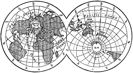
THE LAND AND WATER HEMISPHERES
The Oceans consist of one great fluid mass, and in extent covers three times the area of the dry land. There is also about three times as much land to the north of the equator as there is to the south of it. Though the waters of the ocean surround the land on every side, yet they are broken up into certain areas by the arrangement of the land portions, and to these various parts we give particular names.
The Atlantic Ocean, lying between the western shores of Europe and Africa and the east coast of America.
The Pacific Ocean, lying between the west coast of America and the east coast of Asia.
The Indian Ocean, lying between the south of Asia and the Antarctic circle.
The Arctic Ocean, lying within the Arctic circle.
The Antarctic Ocean, lying within the Antarctic circle.
VAST EXTENT OF THE OCEANS
The Atlantic is the most branching of the oceans, and is especially distinguished by the number and great size of its inland seas. Two of these, the Mediterranean Sea and the Gulf of Mexico, lie in the warm regions; and two, Hudson Bay and the Baltic Sea, in colder latitudes.
The broader seas are represented by the Caribbean Sea, within the tropics and the Gulf of St. Lawrence and the North Sea in temperate latitudes. The Gulf of Guinea, and the Bay of Biscay, are examples of the more shallow coast waters.
The Pacific is particularly rich in vast border seas, a continuous series of which lines the Asiatic and Australian coasts. Among these are the Behring Sea, enclosed by the peninsula of Alaska and the Aleutian Islands; Okhotsk Sea, enclosed by Kamchatka and the Kurile Islands; the Sea of Japan, and the North and South China seas; and the Arafura, Coral, and New Zealand seas, on the Australian Coast.
Only two inland seas of considerable size—the Gulf of California in North America, and the Yellow Sea in Asia—mark this entire basin.
The Indian Ocean is characterized by gulfs, two of which form the entire extension of the basin; namely, the Gulf of Bengal, and the Arabian Sea. It has also two inland seas of considerable extent, the Red Sea and the Persian Gulf, isolating the peninsula of Arabia from the adjacent continents; but border seas are wholly wanting in the Indian Ocean.
The Arctic Ocean is a partially enclosed sea, which a comparatively inconsiderable rise of the sea-bottom would convert into a true Mediterranean. Three openings connect it with the Pacific and Atlantic Oceans, namely, Behring Straight (narrow and shallow), Davis Straight, and the broad expanse of water lying between Norway and Greenland. Of these, the last is by far the most important, for through it the warm waters of the Gulf Stream find access to the Polar basin, and keep the sea free from ice throughout the year. This current is supposed to flow feebly along the coast of Siberia, until, deflected by the land, it becomes merged in the cold counter-currents which, passing along the eastern coasts of Greenland and Labrador, carry immense masses of ice into the Atlantic.
PICTORIAL DIAGRAM OF THE STRUCTURE OF THE EARTH IF THE WATERS WERE REMOVED
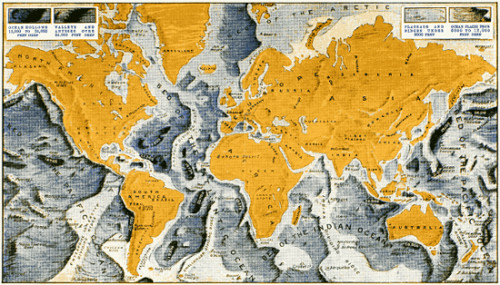

Ridges, mountains, plateaus, which may represent submerged continents of the past, and many an abyss that exceeds in depth the height of the highest mountains, are shown above. The shallow coasts, marked by the lightest shade, are part of the present Continental Shelf, and do not exceed six hundred feet in depth. Beyond this shelf, as a rule, the oceans rapidly attain great depths. Our knowledge of the ocean bed has been obtained from the extensive soundings.
Large images: Map (624 kB) Section (191 kB)
The Antarctic Ocean is situated about or within the antarctic circle. The great Southern Ocean is that part of the ocean which surrounds the world between the latitude of 40 degrees south and the antarctic circle. The northern portions of this band are often called the South Atlantic, South Indian and South Pacific, while the southern portions are usually called the Antarctic Ocean. The average depth of the continuous ocean which surrounds south polar land is about two miles; it gradually shoals toward antarctic land, which in some places is met with a short distance within the antarctic circle. Life is abundant in the surface waters, and at the bottom of the ocean.
HOW THE FLOOR OF THE OCEAN APPEARS
As a rule the sea is shallowest near the land, though in a few cases there is a sudden descent to a great depth at a very short distance from the coast. Lowlands have usually shallow seas near the coast, and highlands deep water.
Along the American shores, in the latitude of New York, the depth, for a distance of more than 100 miles, is less than 600 feet; then suddenly the bed descends, by a steep slope, to the depth of 6,000 or 9,000 feet. After a comparatively narrow interval, a second terrace descends to the main basin, from 15,000 to 18,000 feet deep.
The bottom of the trough of the ocean, in general, is equally varied with that of the land surface of the globe, forming mountains, hills, valleys, tablelands, etc. In many parts these marine mountains reach above the surface and form islands. On the table land extending across the Atlantic between Newfoundland and Ireland is laid the submarine-telegraph cable which connects the two hemispheres.
The Depth of the Oceans. The average depth of the Pacific Ocean has been estimated at between 15,000 and 18,000 feet, which is slightly greater than that of the Atlantic. The deeper portions may be learned on reference to the map. The western portion of the North Pacific in particular shows some very deep depressions. To the east of Japan lies a long deep trough which in one part has furnished the sounding of nearly five and one-half miles. This abyss is often called the Tuscarora Deep. South of the Ladrone Islands, in the Caroline Archipelago, there is also a deep abyss where an English ship, the Challenger, obtained a sounding of nearly 27,000 feet. In the Pacific soundings of over 30,000 feet have been made.
The Indian Ocean has an average depth of about 12,000 feet, and the deepest soundings have been taken on the eastern side. It is interesting to observe that the deepest sounding, about five and three-quarter miles, in the South Pacific somewhat exceeds the height of the highest mountain. Mount Everest has a height of 29,000 feet above the sea level. And it must also be noted that the mean height of the land, 1,000 feet, is only about one-twelfth the mean depth of the whole ocean, 12,000 feet. (See colored map showing comparative surfaces of land areas and ocean depths.)
Inland and Border Waters. These enclosed basins belong to the structure of the continents, rather than to the oceans. All are shallow in comparison with the great basins with which they are connected, as is apparent from the depths given below.
The Gulf of Mexico is from 5,000 to 7,000 feet in depth. The deepest part of the Caribbean Sea, on a line connecting Porto Rico and Costa Rica, averages 7,000 feet, and near the latter it reaches a depth of 14,000; but the ocean, immediately outside of the Lesser Antilles, is more than 18,000 feet deep.
The Mediterranean is divided into two basins, by a rocky isthmus, from 50 to 500 feet below the surface, lying between Sicily and Cape Bon, in Africa. The western basin is over 9,000 feet in depth, and comparatively uniform; while the eastern is more irregular, varying from 6,000 near the center, to 13,000 feet, south of the Ionian Islands. The Red Sea has an irregular bottom, with an average depth of 3,000 feet, but in some places it reaches 6,000.
The Baltic Sea, being a simple depression in the great European plain, is but a few hundred feet deep. In the North Sea, the depth averages 300 feet, and rarely exceeds 600. The continent is here prolonged in the form of a submarine plain, whose highest portions form the British Isles.
The Border Seas of Asia, lying within the chain of continental islands, are only a few hundred feet in depth, while immediately without those islands, abrupt slopes descend to the great depths of the Pacific basin.
Smaller inlets are also of frequent occurrence, especially in districts where mountain ranges approach the borders of the ocean. Such are the lochs of Scotland, the voes of the Shetland Islands, and the fiords of Norway and Greenland. The term lagoon is usually applied to lake-like inlets.
Salt and Other Ingredients of Sea-water. The waters of the ocean are salt, holding in solution various saline matters. The saline ingredients amount to rather more than thirty-five grains in a thousand grains of sea-water. The most abundant of these is chloride of sodium or common salt, which in general forms about a third of the whole. Besides this, sea-water contains some magnesia, lime, potash, and traces of iodine and bromine.
The following table exhibits the exact percentage composition of sea-water.
One hundred parts by weight of sea-water contain:
Water 96.470
Sodium Chloride 2.700
Magnesium Chloride .360
Potassium Chloride .070
Magnesium Sulphate .230
Calcium Sulphate .140
Calcium Carbonate .003
Magnesium Bromide .002
Traces of Iodides, Silica, etc., estimated .025
100.000
How the Sea gets its Color. The color of sea-water is due to the character of the skies and clouds above, and to vegetable and animal objects growing and living in it. The luminosity or phosphorescence of the ocean is due to the decay of animal and vegetable substances, but in some cases it arises from the presence of myriads of living animals, which, like the glow-worm and fire-fly of the land and air, have the power of emitting light.
Ocean Temperature. The water of the ocean appears generally to agree with that of the climate in which it is situated. In warm latitudes the temperature of the deep sea diminishes with the depth below the surface until a certain depth is reached, below which it appears to retain an equable temperature, this being about 40 degrees Fahrenheit. In the Polar Seas, where the temperature of the surface is lower than 40 degrees the heat increases downward until it reaches that point. In latitude 70° the temperature of the ocean is considered to be the same at all depths.
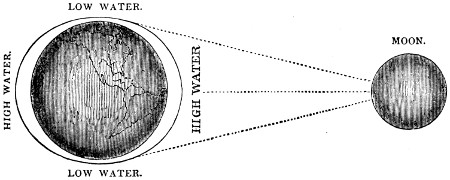
HOW TIDES ARE FORMED BY ACTION OF THE MOON
The moon pulls the waters of the earth into a great double wave heaping it up on the side nearest to the moon and on the opposite side. As the earth rotates, this double wave moves round the earth, and the crests and troughs alternately produce high and low tide. Thus there are two high and two low tides daily, at intervals of about twelve hours, or half a Sun or day.
CAUSE OF THE TIDES, WAVES AND CURRENTS OF THE OCEANS
The waters of the ocean are retained in their bed by the attraction of gravitation. This power is great in proportion to the mass; and as the earth is of much greater mass than the particles of water on its surface, it attracts them and keeps them in their assigned places. But the sun and moon also possess this power of attraction, and notwithstanding their distance, attract and draw them up to a certain elevation. The vast mass of the waters being drawn up by the moon into a mountain or curve of water forms what is called the “great primary or tidal wave.”
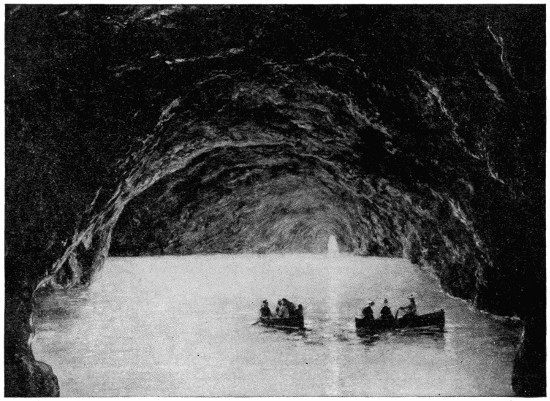
VAST OCEAN CAVERN AT CAPRI, WIDELY KNOWN AS THE “BLUE GROTTO”
This remarkable cavern, on the shore of the island of Capri, at the entrance of the Bay of Naples, is entered from the sea, and is one hundred and eighteen feet long and forty feet high, with a breadth of ninety-eight feet at its widest part. It derives its name from the wonderful blue reflection of the sun’s rays through the water, which gives the interior its marvelous beauty and majesty. The cavern has been created by the ceaseless action of the tide.
Ebb-tide and Flood-tide. This drawing up of the waters of mid-ocean causes a recession from the shores, thus giving rise to ebb-tide, or low water. But when the temporary attraction ceases the waters flow back to their natural level, returning to shore and forming flood-tide, or high water. This culmination or rising of the waters in the great tidal wave takes place twice in twenty-four hours and fifty minutes. The combined influence of the sun and moon at new and full moon augments the size of this wave, and causes the “spring-tides” at those periods.
Height of Tides. High water at the various points along the coast is dependent on the return of this great wave, though some variations are caused by local peculiarities; and the height of the tide also varies greatly in different parts of the earth.
On the eastern coast of North America, the average rise of the tide is from nine to twelve feet. At the entrance to the Bay of Fundy, however, it rises eighteen feet, while at the head of that bay it reaches sixty, and in the highest spring tides, even seventy feet. At Bristol, in England, the spring tides rise to forty feet; and at St. Malo, on the south coast of the English Channel, they reach fifty feet.
THE MAELSTROM, CHARYBDIS AND HELL GATE
Differences in level, produced by high tides, cause currents which vary in force and direction with the condition of the tide, producing, in some cases, dangerous whirlpools. The famous Maelstrom, off the coast of Norway, is but a tidal current, which rushes with great violence between two of the Lofoden Islands, causing a whirling motion in the water which is reversed at each ebb and flow of the tide.
Such is, also, the famous whirlpool of Charybdis, in the Straight of Messina, and many others of less note. The powerful currents of Hell Gate, in the passage from Long Island Sound to New York Bay, are due to a similar cause, high water occurring at different hours in the bay and in the west end of the sound.
WHAT CAUSES THE WAVES OF THE OCEAN
The waves of the ocean, which are caused by the action of the wind, and which are called secondary or wind waves are of a totally different character from the tidal wave. The influence of the wind is supposed not to extend to a greater depth than forty or fifty feet, the deep sea, though raised in a great mass by the grand tidal movement, being free from agitation. Wind waves at a distance from the shore are comparatively low and long, but in shoal water they assume a greater curvature, and fall on the beach either in gentle ripples or in mighty breakers, according to the depth of the water and the force of the wind. The heavy swell which occasionally takes place, called the “ground sea,” is supposed to originate in distant storms of wind.
THE RIVERS IN THE SEA
Currents in the ocean arise from various causes. They may be produced by long-continued gales of wind, by the melting of polar ice, or by any cause that may give rise to onward movements of limited portions of the great mass of waters. Other currents, and of these only is it necessary to speak in this connection, are permanent. The most remarkable of these are the polar currents and the equatorial currents.
Polar Currents are produced by the perpetual movement of the waters from the poles to the equator. In accordance with the laws of mechanics, an accumulation of the waters takes place on that part of the globe which has the greatest velocity of motion; and as the earth in turning on its axis moves with far greater velocity at the equator, the waters continually flow toward that line from the poles.
Equatorial Currents. This accumulation of the waters at the equator tends to produce the equatorial currents, which consist of the continuous progression of the tropical seas in a westerly direction. When the wave brought by the polar currents arrives—coming as it does from regions where it naturally has less velocity—it does not at once acquire the velocity of the earth’s motion at the equator; and since the rotation of the earth is from west to east, this portion of the water lagging behind forms a stream or current which has an apparent motion from east to west, that is to say, apparent as regards the earth, but real in relation to the adjacent land and water. The trade winds, which in this zone blow constantly in the same direction, lend their aid in maintaining the equatorial current.
THE GREAT SYSTEMS OF OCEAN CURRENTS
An extensive system of currents appears to arise in the Antarctic Ocean. A current of cold water flowing northward joins the equatorial current in the Pacific. Entering the Indian Ocean, it maintains its westerly course until it approaches the shores of Africa; then bending southward it rushes through the Mozambique Channel, and doubling the Cape of Good Hope travels northward until it arrives at the Bight of Benin. This current then joins the equatorial current, and crossing the Atlantic from the coast of Guinea to that of Brazil, it is divided into two branches by the projecting headland of Cape San Roque, one flowing southward and the other northward.
The Gulf Stream. After passing the Island of Trinidad, this great oceanic current enters the Gulf of Mexico, and there acquires a high temperature, and sweeping round that sea it again pours forth into the Atlantic, forming the most powerful of known currents, called the Gulf Stream. Issuing from the Gulf of Mexico, this current of warm water rushes with considerable force through the Bahama Channel; then taking a northerly course it travels along the eastern shores of North America, and at Newfoundland is turned to the eastward by an opposing cold current which sets in from Baffin’s Bay. It now maintains an easterly direction, and crossing the Atlantic arrives at the Azores in about twenty-eight days, and divides its waters on the coast of France and Spain: one portion goes southward and at length joins the grand current which sets from the coast of Guinea; and another portion travels northward and skirts the western coasts of Europe. These currents are seldom more than 500 feet deep.
ATMOSPHERE, CLIMATE AND WEATHER
The atmosphere is the vast ocean of air that envelops the earth and makes life possible on our globe. It absorbs the heat and vapors caused by the action of the sun upon the surface of both land and water, and is the medium through which the ever-changing phenomena of climate and weather are produced. The two great forces of nature acting in connection with it are gravitation and heat, or solar radiation; and the results of their ceaseless action may be summed up as follows: (1) Temperature, or heat, which we soon learn to know by our senses, and to measure by the thermometer. (2) Evaporation, which changes the weight of the air by carrying invisible moisture through it. This change of weight is indicated by the barometer. (3) Condensation, producing fog, dew, rain, hail, and snow; all estimated accurately by the rain gauge or pluviometer. (4) Motions, as in the winds, varying from the gentle breeze to the awful cyclone, the force and velocity of which are indicated by the anemometer. (5) Electricity, producing lightning, thunder, magnetic and chemical changes in the atmosphere. (6) Optical Phenomena, such as rainbows, haloes, coronas, mirage, and the auroras.
THE ATMOSPHERE: ITS EXTENT, CHARACTER, USE AND EFFECT
The Earth is enveloped in its own atmosphere, which like a transparent covering surrounds it, and revolves with it. This atmosphere does not extend to more than forty or fifty miles above the earth’s surface, and is higher at the equator than at the poles.
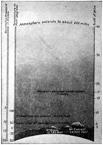
Large illustration (278 kB)
WHAT THE ATMOSPHERE IS COMPOSED OF
The atmosphere is an elastic fluid consisting of a mixture (not a compound) of oxygen and nitrogen, in the proportions of about twenty-one of the first to seventy-nine parts of the last named. It also contains a small quantity of carbonic acid gas, and a yet smaller quantity of ammonia; and water in the form of invisible vapor is always present in it, though the quantity is subject to great variations. All these substances move freely among each other, and are continually changing places: the oxygen being ever ready to perform the office assigned to it of sustaining life and combustion; the carbonic acid to promote the growth of vegetation; the nitrogen to perfect the fruits of the earth, and the vapor to descend to the thirsty ground, in the form of showers and dew.
The atmosphere is elastic, and therefore capable of expansion and compression; and is also a ponderable body. The consequence of these properties is, that it is much lighter and thinner in the upper regions than nearer the earth’s surface; for at the sea-level its whole weight presses on its lower strata and gives it greater density. Ascending from the earth’s surface it becomes gradually lighter and thinner, and at great elevations is so rarefied as to be unsusceptible of sustaining life.
HOW THE ATMOSPHERE IS WEIGHED AND MEASURED
The weight of the atmosphere at the level of the sea is equal to about fourteen and one-half pounds on every square inch of surface. This weight is balanced by a column of mercury thirty inches in height; but at an elevation of 18,000 feet it would be balanced by a column of only fifteen inches in height, and at 36,000 by one only seven and one-half inches in height. It is on this principle that the mercurial barometer has been constructed; and since the mercury in the barometer stands at the same point at all places at the sea-level, and falls in a regular ratio on ascending therefrom, this instrument forms a most useful standard for measuring altitudes.
As we ascend from the sea the atmosphere becomes colder; but, as with the density, the temperature does not appear to pass through regular gradations of change. From experiment, however, it has been assumed that the atmosphere loses one degree of heat by Fahrenheit’s thermometer for every 350 feet of ascent; and hence even in the hotter regions very lofty mountains are covered with perpetual ice and snow.
DISTRIBUTION OF TEMPERATURE OVER THE EARTH
The amount of heat produced by the sun upon the Earth’s surface, is greatest near the Equator, and diminishes gradually towards the Poles. Three general causes, each referable to the spherical form of the Earth, combine to produce the gradual diminution of temperature from the Equator to the Poles.
1. The angle at which the Sun’s rays strike the surface. In the Equatorial regions they are perpendicular to the surface of the sphere, and there produce their maximum effect; but, on account of the curved outline of the globe, they fall more and more obliquely with increasing latitude, and the intensity of action diminishes proportionately. At the Poles their effect is practically nothing.
2. The area on which a given amount of heating power is expended, is least at the Equator, consequently the resulting heat is greatest. The area covered increases, and the effect diminishes, with the increasing obliquity of the Sun’s rays in higher latitudes, which, as we have seen above, results from the spherical form of the Earth.
3. The absorption of heat by the atmosphere, as the Sun’s rays pass through it, is least where they fall perpendicularly,—that is, in the Equatorial regions,—and increases, with their increasing obliquity, towards the Poles.
EFFECT OF THE MOTIONS OF THE EARTH
The Earth revolves constantly around the Sun, and at the same time rotates upon an axis inclined twenty-three and one-half degrees towards the plane of its orbit. In consequence of the inclination of the axis, the declination of the Sun, or its angular distance from the Equator, varies with the advance of the Earth in its orbit, causing periodical variations in the length of day and night, and, consequently, in temperature.
Vernal Equinox. On the twentieth of March, at mid-day, the Sun is vertical at the Equator. Rising directly in the east it ascends the heavens to the zenith, and, descending, sets directly in the west.
The illuminated hemisphere extends from pole to pole, and embraces half of every parallel of latitude; hence every point on the Earth’s surface is under the rays of the Sun during half of the diurnal rotation; the days and nights are equal all over the globe; and the heating power of the Sun is the same in both the northern and the southern hemisphere.
Summer Solstice. As the Earth advances in its orbit the vertical Sun declines northward; and on the twenty-first of June, at the Summer Solstice, it is over the northern Tropic, twenty-three and one-half degrees from the Equator.
The illuminated hemisphere, extending ninety degrees on each side of the parallel of the vertical Sun, reaches twenty-three and one-half degrees beyond the North Pole; but, at the south, it barely touches the Antarctic circle. It embraces more than half of each parallel north of the Equator, hence throughout the northern hemisphere the day is longer than the night, the difference in their duration increasing with the latitude; and all points within the Arctic circle are in the light during the entire rotation.
In the southern hemisphere, less than half of each parallel being illuminated, the night is longer than the day, and within the Antarctic circle there is constant night. The heating power of the Sun is now at the maximum in the northern hemisphere, while in the southern it is at the minimum.
Autumnal Equinox. On the twenty-second of September, the distribution of light and heat upon the two hemispheres is the same as at the Vernal, and at the Winter Solstice, on the twenty-second of December, it is the reverse of that at the Summer Solstice.
WHAT CAUSES THE SEASONS AND DAY AND NIGHT
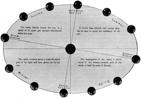
FIGURE ILLUSTRATING THE CHANGE OF SEASONS THROUGHOUT THE YEAR
The change of seasons is caused by the revolution of the earth around the sun, and the inclinations of the planes of the equator and ecliptic. These causes also account for the difference in the length of the days and nights and the difference in the height of the midday sun. The exact duration of the seasons we get by observing the dates of equinoxes and solstices.
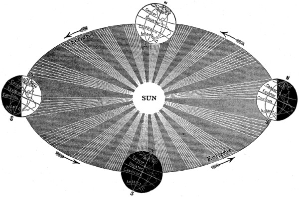
FIGURE SHOWING THE CAUSE OF DAY AND NIGHT
The revolution of the earth gives us the length of the year; its rotation on its axis, the length of the day and night, by causing the risings and settings and daily apparent motion of the sun and stars.
EFFECT OF UNEQUAL DAYS AND NIGHTS ON TEMPERATURE
The inequality in the length of the days in different parts of the year, occasioned by the inclination of the Earth’s axis, is of itself sufficient to produce a marked variation in temperature.
During the day the Earth receives from the Sun more heat than it radiates into space; while during the night it radiates more than it receives. Hence a succession of long days and short nights results in an accumulation of heat, raising the average temperature and producing summer; while long nights and short days result in a temperature below the average, producing winter.
Again, the heating power of the Sun in each hemisphere is greatest at the period of the longest days, because of its greater altitude in the heavens; and least at the period of shortest days. Thus long days and a high sun operate together to produce the high temperature of summer; while long nights and a low sun cause the low temperature of winter.
The following table gives the length of the longest day, excluding the time of twilight, and of the shortest night, in the different latitudes, with the difference of duration in hours and minutes, thus exhibiting more clearly the above law.
TABLE OF UNEQUAL DAYS AND NIGHTS
LATITUDE Longest Day Shortest Night Difference
Equator 12 .0 hours 12 .0 hours 00 .0 hours
10° 12 .7 „ 11 .3 „ 1 .4 „
20° 13 .3 „ 10 .7 „ 2 .6 „
Tropics 13 .5 „ 10 .5 „ 3 .0 „
30° 14 .0 „ 10 .0 „ 4 .0 „
35° 14 .5 „ 9 .5 „ 5 .0 „
40° 15 .0 „ 9 .0 „ 6 .0 „
45° 15 .6 „ 8 .4 „ 7 .2 „
50° 16 .3 „ 7 .7 „ 8 .6 „
55° 17 .3 „ 6 .7 „ 10 .6 „
60° 18 .7 „ 5 .3 „ 13 .4 „
Polar Circles 24 .0 „ 0 .0 „ 24 .0 „
671⁄2° 1 month 0 .0 „ ...
691⁄2° 2 months 0 .0 „ ...
73.3° 3 „ 0 .0 „ ...
78.3° 4 „ 0 .0 „ ...
84° 5 „ 0 .0 „ ...
North Pole 6 „ 0 .0 „ ...
LAW OF VARIATION OF DAY AND NIGHT
The inequality of day and night increases slowly in the tropical regions, but more and more rapidly towards the polar circles. Beyond these circles the Sun, in the hemisphere in which it is vertical, makes the entire circuit of the heavens, without sinking below the horizon, for a period varying from twenty-four hours to six months; while in the opposite hemisphere there is a corresponding period of continuous night.
RESULT OF THIS LAW IN DIFFERENT ZONES
In the tropical regions, where the days and nights vary little in length, the temperature is nearly uniform throughout the year; while the increasing inequality of day and night towards the Poles, causes an increasing difference between the summer and the winter temperature.
Again, the length of the day, in the summer of high latitudes, compensates for the diminished intensity of the Sun’s influence; so that the temperature, in the hottest part of the day, may equal, or even exceed, that within the tropics. A summer day in Labrador or Petrograd may be as warm as one under the Equator; but in the former latitudes there are only a few days of extreme heat in the year, while with increasing nearness to the Equator the number of warm days constantly increases.
HOW THE SEASONS VARY IN DIFFERENT LATITUDES
The high latitudes have short, hot summers, and long, severe winters. The transition seasons, spring and autumn, on account of the very rapid change in the length of the days, are short and scarcely perceptible.
In the middle latitudes the summer and winter are more nearly equal in length, with less difference in the extreme temperatures; and the transition seasons are distinctly marked. Farther towards the Equator the summer increases in length, and the winter diminishes, while the tropical latitudes have constant summer.
WINDS AND OTHER AIR CURRENTS
The winds appear to be caused by partial changes in the density of the atmosphere in a great measure arising from a diverse distribution of heat. When air is warmed it becomes less dense, or, in other words, it occupies a greater space. If an adjacent stratum of air be cooler, it will on coming in contact with the warmer air expand and pour into space occupied by the latter, thus forming a current. The greater the difference between the temperature of the one or other portion, the greater will be the force which the cold portion will rush into the space occupied by the warm portion, or, in other terms, the more violent will be the wind. In temperate climates the winds are variable; but in some parts of the world they blow with great regularity, and in others are subject to periodical changes.
WHAT CAUSES THE TRADE-WINDS
The most remarkable of the regular winds are the trade-winds. The atmosphere at the surface between the tropics is much warmer than in the higher latitudes; and since air expands when heated, the light warm air of intertropical regions perpetually rises, and its place is as perpetually supplied by the colder air from the north and the south. If it were not for the Earth’s rotation, these would be merely north and south winds; but like the equinoctial water-currents, these cool currents of air coming from regions which have not an equal velocity of rotation with the air at the equator, pause and hang back, and thus these aerial currents acquire a westerly direction, forming north-easterly constant winds in the northern hemisphere, and south-easterly in the southern hemisphere.
MONSOONS AND THEIR LOCATION
The monsoons or periodical winds of the Indian Ocean owe their origin to the same cause which gives rise to the trade-winds, though they acquire a different character in consequence of the proximity of the land. In the southern portions of the ocean which are remote from this cause of disturbance, the trade-wind blows with its wonted regularity; but in the seas occupying the region between the eastern coast of Africa on the one side, and the Malay peninsula and the island of Sumatra on the other, the course of the trade-wind is reversed for half the year. This change occurs from April to October; the sun at that period being vertical north of the equator, and the land in the adjacent regions acquiring in consequence a high temperature, and the air over the sea being cooler than that over the land, a south-west wind prevails. This wind, called the “south-west monsoon,” commences at about three degrees south of the equator, and passing over the ocean arrives charged with moisture, and accordingly usually deposits copious supplies of rain in India and some of the adjoining territories. In the remaining half of the year, or from October to April, the wind assumes the ordinary north-easterly direction of the trade-wind.
Sea-breezes, which occur in regions bordering on the ocean in hot climates, are produced by causes similar to those which give rise to the south-west monsoon, but on a more limited scale of action, and changing their direction daily.
THE WHIRL OF THE HURRICANE
Hurricanes are storms of wind which sweep or whirl round a regular course, and are at the same time carried onward along the surface of the Earth. In the northern hemisphere the whirling motion follows the course of east, north, west, and south to east again, and in the southern hemisphere it takes the opposite course. In the Atlantic Ocean, the principal region of hurricanes lies to the eastward of the West India Islands. They are also frequent in the Indian Ocean, at no great distance from the island of Madagascar. The “typhoons” of the China seas, and the “ox-eye” of the Cape of Good Hope, are also revolving storms.
TORNADOES AND OTHER CHARACTERISTIC STORMS
The tornadoes of the western coast of Africa, the pamperos of South America, and the northers of North America appear to be of a different character, and not to possess a revolving motion. The sirocco of Italy and Sicily, and the solano of Spain, as also the simoon of Arabia, and the harmattan of western Africa, are all winds which owe their origin to the heated surfaces of Africa and Arabia. The principal difference between these winds appears to be, that the sirocco and the solano acquire some moisture in their passage across the Mediterranean, and therefore do not possess that extreme degree of aridity which forms the distinguishing character of the simoon and the harmattan.
CLOUDS—THEIR FORM AND CLASSIFICATION
Clouds are continually varying in their form and appearance, but may be classed under the four principal heads of the cirrus, the cumulus, the stratus, and the nimbus.
The cirrus is a light, fleecy cloud resembling a lock of hair or a feather.
The cumulus or summer cloud is generally massive and of a round form; sometimes of small size, and sometimes covering nearly the whole sky, and occasionally appearing in the horizon like mountains capped with snow.
The stratus is a horizontal, misty cloud sometimes observed on fine summer evenings comparatively near the ground, and often crossing the middle regions of mountainous or hilly districts.
The nimbus or rain cloud has a uniform gray tint; it is fringed at the edges when these are displayed, but usually covers the whole sky. The region of clouds is a zone extending in the atmosphere from about one to four miles above the Earth. The most elevated clouds, which are light and fleecy, are those comprehended under the name of cirrus, and the lowest are those which are called stratus.
The cirro-cumulus, cirro-stratus, and cumulo-stratus are only modifications and combinations of the above-named principal classes.
FORMS OF ATMOSPHERIC VAPOR
Warm air is capable of holding suspended a larger quantity of moisture than cold air, and therefore the amount of vapor present in the atmosphere is subject to great variations.
WHAT CAUSES DEW
These facts also account for the formation of dew, which is caused by the reduction of the temperature and the deposition of the moisture which the warmer atmosphere of the day had held in suspension. Dews will hence be usually most abundant when cool nights succeed warm days, and on a clear night than when the skies are obscured by clouds, because a cloudless sky is usually much colder than a beclouded one. It is also essential for the copious formation of dew, that the ground or other substance on which it is deposited should be much cooler than the superincumbent air; for if the ground be warm it will impart its temperature to the air near its surface and dew will not be formed.
FORMATION OF MISTS AND FOGS
When the ground or water is warmer than the air, mists and fogs are frequently formed; and since water and marshy surfaces cool less rapidly than dry land, mists and fogs are of more common occurrence in low, damp situations than in dry, elevated districts. They are formed by the condensation of the vapor, or, in other terms, its transformation into the minute globules of water, which instead of descending to the earth in the form of dew, remain suspended above the land or the water.
RAIN, HAIL AND SNOW
Clouds are formed by the condensation of vapor at considerable but various elevations in the atmosphere. Vapor is always invisible, clouds, therefore, are not vapor but water, and consist of a fine watery powder, the size of each particle being exceedingly minute; and consequently they are so light that clouds formed of an accumulation of such particles are readily borne forward by the winds. Clouds are sometimes suddenly formed and as suddenly disappear, probably owing to sudden and partial changes of temperature. When a considerable difference of temperature prevails in the aerial currents which may come in contact with the local atmosphere, a further condensation takes place, and the particles of this fine watery powder unite into drops, and, becoming heavier, fall to the earth in the form of rain, hail or snow.
SNOW AND SNOW- CRYSTALS
Vapor condensed in air having a temperature below thirty-two degrees Fahrenheit freezes, or passes to a crystalline form, producing snow. Snowflakes occur in a great variety of forms, which usually present the outline of either a regular hexagon or a six-pointed star.
Their size depends upon the temperature and the relative humidity of the air through which they fall, for, like raindrops, they increase by successive additions from the vapors with which they come in contact in descending. Thus in mild weather they are much larger than in very cold weather.
PICTORIAL CHART OF THE CLOUDS, SHOWING THEIR FORMS AND POSITION
1. Cirrus (sir´rus).—Small curl-like clouds, usually high in the heavens. 2. Cirro-stratus (sir-ro-strā´tus).—Intermediate between the cirrus and stratus. 3. Cirro-cumulus (sir-ro-kū´mu-lŭs).—Resembling the scales of mackerel. 4. Alto-cumulus (al´tō-kū´mu-lus).—High cumulus clouds. 5. Alto-stratus (ăltō-strā´tūs).—High stratus clouds. 6. Strato-cumulus (strā´to-kū´mu-lŭs).—Forms of cumulus and stratus combined. 7. Nimbus (nim´būs).—A rain cloud. 8. Cumulus (kū´mū-lus).—A conical heap of clouds. 9. Cumulo-stratus (kū´mu-lo-stra´tŭs).—Intermediate between the cumulus and the stratus. 10. Stratus (strā´tŭs).—Arranged in a horizontal band or layer. 11. Fracto-stratus (frăk´tō-strā´tŭs).—Broken forms of stratus. 12. Fracto-cumulus (frăk´to-kū´mu-lus).—Broken forms of cumulus.
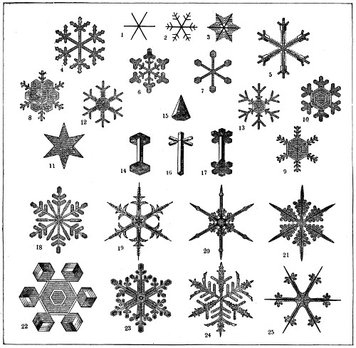
THE BEAUTIFUL CRYSTAL-FORMS OF SNOWFLAKES
1-3. Six-rayed stars. 4-13, 18-25. Combinations of six-rayed stars with decorated flat surfaces. 14, 16, 17. Combinations of stars and columns. 15. A true pyramid.
When the lower air is warm enough partially to melt the crystals, they form minute balls. When raindrops, formed in the upper air, fall through a cold current, they are often frozen, producing sleet instead of snow.
WHERE PERMANENT SNOW EXISTS
Though the winter snows upon the plains, and the slopes of mountains of medium height, disappear during the warm season; yet, in all latitudes, the tops of high mountains are covered with a layer of permanent snow, which the summer heat of these great altitudes is not sufficient to melt.
The lower limit of perpetual snow, called the snow line, is found, within the tropics, about three miles above the level of the sea. In temperate latitudes it occurs at the height of a little less than two miles; and at the northern limit of the continents, it is about half a mile above the level of the sea, or, perhaps, even less than this.
On the Arctic Islands, vast fields of snow remain permanently, at a few hundred feet above the sea level.
The winter snows, falling into the icy waters of the polar oceans, are but partially dissolved; and, remaining upon the freezing surface, they help to form those vast ice floes which encumber the polar seas at all times.
The following table gives the observed height of the snow line in the different latitudes:—
HEIGHT OF THE SNOW LINE
Lat. N. New World Feet
75° North Greenland 2,300
54° Unalaska 3,500
48° Mt. Baker, Oregon, about 8,000
43° Rocky Mountains 12,500
39° Rocky Mountains 14,500
38° Sierra Nevada 11,000
19° Popocatepetl, Mexico 14,900
5° Tolima, Columbia 15,300
Lat. S. 1° Andes of Ecuador 15,800
17° Andes of Bolivia, west side 18,500
17° Andes of Bolivia, east side 15,700
33° Andes of central Chili 14,700
42° Andes of Patagonia 6,000
54° Andes of Straits of Magellan 3,700
75° Bear Island 600
71° Mageroe, Cape North 2,300
67° Sulitelma, Lapland 3,800
61° Scandinavian Alps 5,300
50° Altai Mountains 7,000
46° Alps, north side 8,800
46° Alps, south side 9,200
43° Caucasus 11,000
35° Hindu Kush 13,000
31° Himalaya, south side 16,200
31° Himalaya, north side 17,400
12° Abyssinian Mountains 14,000
Lat. S. 3° Kilimanjaro 16,000
44° New Zealand Alps 7,500
HOW SNOW AND ICE FORM GLACIERS AND ICEBERGS
Glaciers (from the French glace, ice) are vast streams of ice which descend from the lower edge of the perpetual snows, like long icicles from a snow-covered roof. They follow the windings of the Alpine valleys, and terminate abruptly in a massive wall of ice, from beneath which the waters of the melting glacier escape, through a large icy vault.
MOST FAMOUS GLACIER REGION
The mountain systems in the middle latitudes, with abundant snows and alternate warm and cold seasons, are most favorable to the formation of glaciers. The best known, and probably the most remarkable glaciers are those of the high Alps, in the heart of which are Mont Blanc, Monte Rosa, and the Bernese Alps. Late explorers have found large glaciers in the Caucasus and in the Himalayas, the last being of the grandest proportions. In the Scandinavia are many which descend, in the deep western fiords, nearly to the sea level.
In the New World glaciers are less frequent. On Mount Shasta and Mount Rainier fine examples are in evidence.
By far the most extensive glaciers however, are found on the snow-covered islands of the polar oceans.
Vast masses of ice, broken from the ends of these glaciers, form the enormous icebergs (mountains of ice) which are so numerous in the polar seas, and are transported by the currents even to middle latitudes.
CLIMATE AND WEATHER
The term climate is used to express the combination of temperature and moisture which prevails at any particular place, or, in more familiar terms, the prevailing weather.
The most prominent causes of diversity of climate are the heat of the sun, the respective position of land and water, and the elevation of land above the level of the sea. To these may be added, as producing considerable though less marked effects, the nature of the soil, the prevailing winds, the position of mountain ranges, and the currents of the ocean.
THE SUPREME INFLUENCE OF THE SUN
The sun is the grand agent in diffusing heat over the earth’s surface. While the sun is above the horizon of any place, that place is receiving heat; and when the sun is below the horizon, it is parting with it by the process called “radiation.” Whenever therefore the sun remains more than twelve hours out of the twenty-four above the horizon of any place, and consequently less than twelve hours below, the general temperature of that place will be above average; and when the reverse occurs, it will be below average. If the temperature depended solely on the heat of the sun, then indeed a tolerably accurate view of the respective climates of the zones of the globe might easily be assumed; but it is so greatly modified by other circumstances, that considerable differences prevail in countries situated in the same parallels of latitude.
HOW AFFECTED BY POSITION OF LAND AND WATER
The relative position of the land and water is an essential cause of this diversity. The waters of the ocean are of very equal temperature, and have a tendency to moderate both heat and cold, wherever their influence extends. Thus when a cold wind passes over the sea, it becomes warmed, while a hot wind becomes cooled; and thus islands generally experience milder winters and more temperate summers than continents. Such countries are said to possess an insular climate. But when any region experiences great severity of cold in winter and a high degree of heat in summer, it is said to possess an extreme or excessive climate. The most striking instances of an extreme climate are drawn from places like Yakutsk, situated in the depths of Siberia, where the difference between the average temperature of winter and summer amounts to the astonishing sum of 101 degrees Fahrenheit.
THE LIFE-GIVING SUN SENDING HEAT AND LIGHT
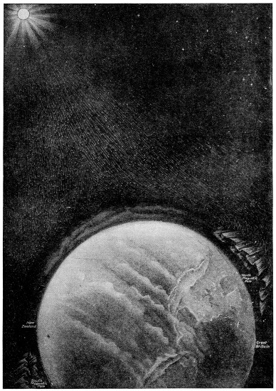
The sun is the great life-giver of our earth. Its waves of light and heat and electricity come to the earth through a measureless ocean of ether and make it a living rather than a dead world. The above illustration shows how these waves are constantly bombarding the earth, and not only giving it life but contributing to it the glory of the seasons, the wonders of color, and the brilliant effects of light which we see in the skies and call Auroras, or Northern and Southern Lights.
Large illustration (347 kB)
INFLUENCE OF ELEVATIONS
A gradual decrease in temperature takes place in the ascent from the sea to the line of perpetual snow. This line, which is called the snow-line, varies in different latitudes, and sometimes, owing to local causes, differs on the same latitude; as a general rule, however, a gradual decrease in elevation of the snow-line takes place as we recede from the equator north and south. The height of this line within the tropics varies from 16,000 to 17,000 feet above the level of the sea, and in the northern hemisphere meets the level at about the eightieth parallel.
MODIFICATIONS BY PREVAILING WINDS, MOUNTAINS AND OCEAN CURRENTS
Countries where the prevailing winds sweep across a wide expanse of ocean are not subject to extremes of heat and cold. Thus the climate of oceanic islands is always moderate, and the climates of all coasts are more equable than in the interior of continents.
Climate is also modified greatly by the position of mountain ranges, especially when ridges extend east and west, screening it from the north or leaving it exposed unsheltered in that direction.
Thus the Carpathians screen Hungary from the cold blasts of the north; while Poland, to the north of that range, and therefore unprotected from those piercing winds, suffers from a very cold and humid atmosphere.
The currents of the ocean are likewise potent agents in the formation of climates, and render places which would otherwise be uninhabitable, fit for man’s habitation. Thus the Polar currents coming to the equatorial regions cool, and the Gulf Stream making its way to Polar regions warms, otherwise extreme temperatures.
RAINLESS AND RAINY REGIONS OF THE EARTH
In some parts of the Earth extensive tracts exist where rain is never known to fall, and if at all only at intervals, and then in small quantities. The rainless districts of the New World include the flat territories of northern Chili and Peru, some parts of Mexico, and some parts of California. In the Old World an extensive rainless band extends from the western shores of Africa to the central regions of Asia, including the Great Sahara Desert, Egypt, part of Arabia, and the Desert of Gobi. Countries so circumstanced, unless like Egypt rendered fertile by the irrigation of a great river, constitute the most arid and desolate regions of the earth.
The quantity of rain which falls in any region depends greatly on local causes, such as the variations of the surface, the prevailing winds or the proximity of the ocean. Rain is usually more copiously deposited in mountains and well-wooded islands than in any other description of surface.
In tropical regions the rains follow the sun, i. e., when the sun is north of the equator, the rains prevail in the northern tropic, and when south of that line in the southern tropic. This forms the rainy and dry seasons to which countries so situated are subject. This does not, however, apply to the whole intertropical regions, for in a zone extending from the fifth to the tenth parallels on each side of the equator there are two rainy and two dry seasons.
In the narrow belt called the variables, between the regions of the north and south trade-winds, rain is almost incessant, accompanied by thunder and lightning. In many parts of the intertropical regions during the rainy season the rain pours down in such torrents that a larger quantity falls in a few hours than in a whole month in temperate North America.
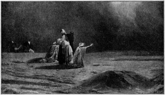
TRAVELERS GROUPED ON THE SANDS OF THE SAHARA, TERRORIZED BY AN APPROACHING SIMOON
The dreaded Simoon of the desert is a whirlwind of terrific force that raises great gyrating clouds of sand, and sweeps forward with suffocating effect upon both man and beasts. It frequently darkens the sky at midday, and sometimes lightning accompanies it caused by the friction of the sand and air, though no rain falls. The Simoon seldom lasts more than twenty minutes.
NATURE WONDERS OF ELECTRICITY AND LIGHT
Electricity produces an infinity of changes in the natural world. It may be artificially elicited or called forth by friction; or by contact of certain substances and the action attendant on this contact. In the one case it is termed ordinary, and in the other case voltaic or galvanic electricity.
All substances are supposed to contain a certain portion of electricity, and if by friction or other means any substance acquires more electrical action than it would naturally possess, it is said to be positively electrified; and if less, it is said to be negatively electrified. Substances when positively electrified attract or draw toward them other substances which are in a state of negative electricity, or even those which are in a natural state, but will repel or force from them substances which are positively electrified. The sudden contact of bodies in an opposite state of electricity is attended with vivid light called the “electric spark,” and accompanied by explosion and shock.
EARTH AND AIR FORM NATURE’S ELECTRIC BATTERY
The earth is always in a state of positive electricity, and the air when pure in a state of negative electricity. Atmospheric air, however, is subject to incessant variations, and hence its “electrical equilibrium” or natural electrical state is subject to be disturbed. This equilibrium will be restored when an explosion has taken place, and thus it is that in peculiar states of the atmosphere thunder storms act a beneficial part in restoring the air to a normal condition. The intensity of electrical action is greater during the day than at night and also in summer than in winter; and diminishes from the equator to the poles.