BOOK OF THE EARTH
Reading edition
THE EARTH AS A PLANET
ITS STRUCTURE: Interior, Crust, Rocks, Fossils, Heat
GEOLOGICAL VIEW OF GROWTH OF THE EARTH
SURFACE OF THE EARTH: Land Forms: Continents, Islands, Mountains, Plains; Water Forms: Springs, Rivers, Lakes, Oceans
CELEBRATED MOUNTAIN PEAKS AND RANGES
ATMOSPHERE, CLIMATE AND WEATHER
NATURAL WONDERS AND FORCES: Volcanoes, Earthquakes, Geysers, Caverns, Waterfalls, Whirlpools, Tides, Deserts, Ocean Depths, Clouds, Seasons, Glaciers, Icebergs, Snow, Rain, Hail, Dew, Coral Islands and Reefs
DICTIONARY OF MINERAL PRODUCTS
TABLES FOR THE IDENTIFICATION OF MINERALS
GEMS AND PRECIOUS STONES
PRONOUNCING DICTIONARY OF SCIENTIFIC TERMS ABOUT THE EARTH
NUMEROUS ILLUSTRATIONS, CHARTS AND MAPS
Life Ages of the Earth Pictorial Diagram Showing the Corresponding Forms of Animal and Plant Life, and Rock Strata in the Earth’s Crust. Rocks and Strata to which they belong
Cenozoic, or Recent Life. Age of Mammals. Alluvium, Gravel, Mud, Sand, Clay, Marl, Limestone. Ceno- zoic
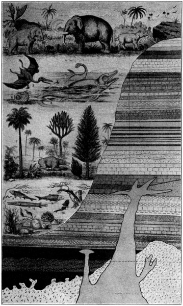
Mesozoic, or Middle Life. Age of Reptiles. Chalk, Gault, Green Sand, Oolite, Clays and Limestone, China Clay, Shales, Cement, Sandstone, Pervian. Meso- zoic
Paleozoic, or Old Life. Age of Invertebrates. Age of Fishes. Age of Acrogens. Coal Massives, Upper and Lower. Millstone, Grit, Mountain, Limestone, Old Red Sand Stone, Iron Ore, Gypsum, Gas, Lead, Zinc, Phosphate, Marble, Sandstone, Shales, Copper. Paleo- zoic
Proterozoic, or Earlier Life. Earliest Forms of Life. Copper, Silver, Lake Superior Iron Ores, and many Metals. Granite, Schists. Emery, Gems, and Building Stone. Protero- zoic
1. Sivatherium, (siv-a-thē´-ri-um). 2. Mastodon, (mas´tō-don). 3. Elephas, (el´e-fas). 4. Palæotherium, (pā-lē-ō-thē´-ri-um). 5. Pterodactyl, (ter-ō-dak´tīl). 6. Ammonites, (am´mo-nitz). 7. Plesiosaurus, (plē-zi-ō-saw´rus). 8. Ichthyosaurus, (ik-thi-ō-saw´rus). 9. Carboniferous, (kär’bŏn-ĭf´ēr-ŭs) fern. 10. Lepidodendron, (lep-ī-dō-den´dron). 11. Calamites, (kal´a-mits or kal´a-mī´tēz). 12. Labyrinthodon, (lab-i-rin´thō-don). 13. Acanthodus, (a-kan-thō´dus). 14. Diplacanthus, (dip-la-kan´thus). 15. Lepidosteus, (lep-i-dos´te-us). 16. Climatius, (clī-măi´tē-us). 17. Zosterites, (zos-ter-i´tēz). 18. Goniatites, (gō-ni-a-tī´tēz). 19. Strophomena, (strō-phŏm´ĕ-na).
Large illustration (465 kB)
BOOK OF THE EARTH
Science tells us that the Earth was once a shining star, a globe of liquid fire. As it cooled down, a crust formed over its surface, composed chiefly of rocks and metals. This crust was rent by the force of the gases shut up within, and thus the mountains, valleys, gorges, and volcanoes were formed. The Earth, indeed, is still upheaving and subsiding, but so slowly that we rarely feel it. Through these agencies the distribution of land and water on the surface of the earth has undergone great changes. The shape of the Earth is that of a sphere somewhat flattened at the poles, and it has a diameter of about 8,000 miles. The solid crust is called the lithosphere—which is surrounded by an envelope of air—the atmosphere—and in part by an envelope of water—the hydrosphere.
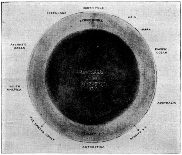
HOW THE EARTH WOULD APPEAR IF CUT THROUGH THE CENTER
Beneath the rocky crust of the earth, thirty-five miles in thickness, there is a broad belt of heavier material to a depth of nine hundred miles. Within this shell lies the great metallic core.
OUR EARTH: ITS STRUCTURE AND SURFACE
Our first glimpse of the earth as a planet shows it as a nebulous star, still intensely hot, and with no solid nucleus, rotating on its own axis, and at the same time revolving around the sun in a nearly circular orbit.
WHAT THE HEAT OF THE EARTH SHOWS
At first it seems hardly possible that the earth could have been a star. But, if we go down beneath the surface of the earth, we find that at a depth of forty or fifty feet there is very slight variation in temperature. When we go yet deeper, as in mines, we find that the earth grows hotter as we descend. The temperature increases on an average about one degree Fahrenheit for every sixty-four feet descent. But this amount is variable according to the locality, geological formation, and dip of strata. In the Calumet and Hecla Mine, observations show an increase of one degree in about every one hundred and twenty-five feet. At Paris, the water from a depth of 1794 feet has a temperature of eighty-two degrees; at Salzwerth, in Germany, from a depth of 2144 feet, a temperature of ninety-one degrees. Natural hot springs, rising from unknown depths, are sometimes scalding hot. One in Arkansas has a temperature of one hundred and eighty degrees.
At a depth of twenty miles, with this continual increase of temperature, the ground must be fully red-hot; and not very much farther down the heat must be sufficient to melt every known substance. The solid earth, then, is merely a thin crust, covering a sea of liquid fire below. The streams of lava poured forth from volcanoes are a proof of the existence of this molten mass beneath our feet.
WHAT CAUSES THE INTERNAL HEAT OF THE EARTH
If we examine the solid crust of the earth we shall not long be at a loss in regard to the origin of this internal heat. We are all familiar with the burning of coal. Now coal is mainly a substance called carbon, and when it burns it unites with oxygen, one of the gases in the air. Many rarer substances, such as silicon, and the metals magnesium, calcium, and sodium, are even more inflammable than carbon, and in burning give rise to solid products. Now the rocks in the earth are found to be made up almost wholly of these very inflammable substances combined with oxygen. The solid portions of the earth, then, are nothing but the ashes and cinders of a great conflagration. Even the waters are made up of hydrogen, one of the most inflammable substances, united with this same oxygen, and, strange as it may seem, they too, are the products of combustion. When, therefore, the materials of which the earth is formed were burning, our planet must have been a fiery star, and the great heat must have reduced all the products of the conflagration to a liquid state.
HOW THE EARTH’S CRUST WAS FORMED
When the fire went out for lack of fuel the mass began to cool at the surface, and a solid crust was finally formed, which with the lapse of time became thicker and thicker. This crust shut in the steam and gases generated in the fiery ocean underneath; and these, acting upon the crust with enormous pressure, heaved it into ridges. At times the strain caused the crust to crack, and forced the melted mass up through it, and in this way hills and mountains were formed. The thicker the crust the greater the strain it would bear before it gave way, and the greater the amount of molten matter driven out through the rent. The highest mountains, then, are the last that were uplifted. In some cases the openings thus made in the crust were never completely closed, and thus volcanoes were formed. These act like safety-valves, and prevent the forces within from accumulating sufficiently to cause fresh rents. But notwithstanding the relief thus given to the pent-up forces, they still manifest themselves in earthquakes.
SHAPE OF THE EARTH A SPHEROID
Like all other planets, the earth is a solid sphere that has undergone a slight flattening at the opposite extremities or poles of the axis of revolution. More accurately, it is an oblate spheroid generated by the rotation of an ellipse about its minor axis. Such a figure would be assumed by a sphere of liquid rotating about a diameter, centrifugal force acting most vigorously at the equator, and tending to overcome the internal forces that keep the molecules together.
SIZE AND DENSITY OF THE EARTH
The smallest diameter of the earth is that measured from pole to pole along the axis of rotation; this is 7,899.6 miles, or about 500,000,000 inches. The greatest diameters are those measured between opposite points on the equator; these are 7,926.6 miles, and, therefore, show that the eccentricity of the earth, or the extent of its departure from the perfect sphere, is very slight.
The circumference of the earth, measured along the equator, is 24,899 miles; the area is 197,000,000 square miles; and the volume is 260,000,000,000 cubic miles. Experiments on the comparative attraction of the earth show that its density is about five and one-half times that of pure water. Its mass is, therefore, approximately six thousand trillion tons.
HOW WE KNOW THE EARTH IS A SPHERE
The ordinary proofs of the sphericity of the earth are: (1) It can be circumnavigated; (2) the appearance of a vessel at sea always indicates a nearer convexity of the earth’s surface; (3) the sea-horizon is always depressed equally in all directions when viewed from an elevation; (4) the elevation of the pole star increases as we travel northwards from the equator; (5) the shadow of the earth on the moon during a lunar eclipse is spherical.
THE ROTATION OF THE EARTH
The earth rotates uniformly about its axis. The time taken to make a complete revolution of three hundred and sixty degrees is called a sidereal day, for it is the interval of time between consecutive transits of any distant star across any meridian of the earth. The time between consecutive transits of the sun across any meridian is called a solar day; the average of these throughout the whole year is called a mean solar day, and is the practical standard of time adopted by civilized nations. The ordinary proofs that the earth rotates are: (1) Bodies falling from a great height have an easterly deviation; (2) Foucault’s pendulum experiment; (3) a gyroscope delicately balanced so as to be free to change the direction of its axis in any way will, if rotated, exhibit an apparent deviation; (4) in northern hemispheres a projectile deviates to the right, in southern hemispheres to the left; (5) the trade winds; (6) Dove’s law of wind-change.
The speed of a body on the equator, due to the diurnal rotation, is about 1,000 miles an hour. The centrifugal force due to this speed diminishes the weight of bodies; if the earth rotated in an hour, they would be thrown off from the surface at the equator.
The axis of the earth is not perpendicular to the ecliptic, but at angle of 66° 32′ to it; the equator is, therefore, inclined to it at an angle of 23° 28′. This unsymmetrical placing of the bulging portions of the earth causes a slow wobbling, or precession of its axis, in the same sort of way as a spinning top will wobble when pushed over on one side. There is also a slight vibration or “nodding” motion of the earth’s axis, known as nutation. The period of each precession is about twenty-one thousand years; if the earth’s orbit occupied a constant position in its plane, the periods would be twenty-six thousand years each. These motions have considerable influence on climate, the modern theories of the Ice Age being connected with the known facts of precessional motion.
THE EARTH A SERIES OF SHELLS OF MATTER
The great bulk of the earth consists of the lithosphere, or solid globe of rocks, with which geology properly deals. It is on the part of this lithosphere, composing a little more than a quarter of the earth’s whole area—55,500,000 square miles—which rises above the seas and is called land, that mankind lives.
The central core is a globe of about 7600 miles in diameter, which is composed of iron and other elements, probably not forming compounds, in the gaseous state, but exposed to such tremendous pressure that it behaves as a solid and extremely rigid body. Outside this core is a shell of liquid matter which consists of all the rocks which we know at the surface in a state of fusion, perhaps one hundred miles in thickness. Upon this magma floats the solid crust, thirty or forty miles thick, which is composed of various rocks, breaking down at the surface into soil. Three-fourths of the surface of this crust are covered by the water of the oceans, the hydrosphere, the rest being dry land. Outside all comes the atmospheric mantle, chiefly composed of air, which supports life, acts as a blanket to keep the earth warm, and as a shield against the blows of meteorites.
HOW THE EARTH’S CRUST IS CONSTRUCTED
An examination of the Earth’s crust shows us that it is constructed of numerous strata of rocks, some of limestone, some of sandstone, and some of clay; and some are very hard, others soft and crumbling, and readily worn away by the action of running streams or the waves of the ocean. To these several substances which form the materials of the earth’s crust we give the name rock. Hence we see that while in ordinary language the word rock denotes a great mass of hard stone, in geology a rock is any mass of natural substance forming part of the earth’s crust. In this sense, loose sand, gravel, and soft clay are as much rocks as hard limestone and granite.
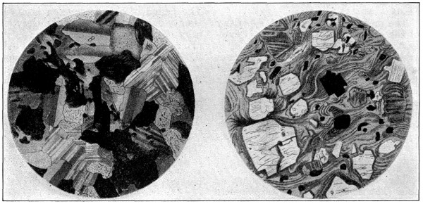
GranitePorphyry
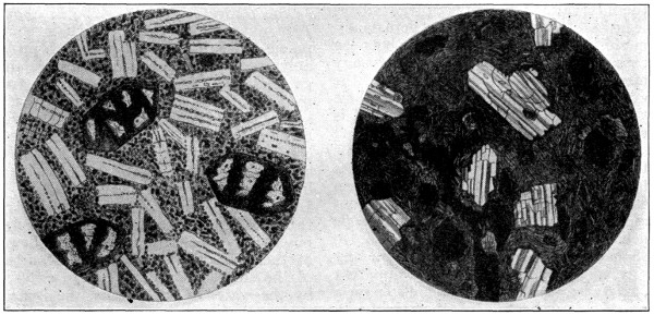
BasaltHornblende
COMPOSITION AND TEXTURE OF STONE AS REVEALED BY THE MICROSCOPE
MATERIALS OF WHICH ROCKS ARE COMPOSED
Rocks are formed of various materials called minerals. If we take a piece of sandstone rock, or a piece of granite, we shall probably be able to notice that the rock is made up of different substances.
On looking at a piece of sandstone, for example, especially if we use a magnifying glass, we see that it is composed of little rounded grains of a glassy-looking substance cemented together. In some specimens these grains are larger than in others. This cementing material is not the same in all sandstones, but in our specimen it is formed of calcium carbonate, for when we drop a little diluted hydrochloric acid on the rock there is an effervescence. The cementing material is dissolved, but the little rounded grains, which consist of quartz, are not affected by the acid. The sandstone, then, consists of quartz grains cemented together by calcium carbonate. It is called a calcareous sandstone.
Now take a piece of granite, and break it with a hammer to get a clean-cut face. On looking at this face we see that the rock is made up of three different substances.
One of these has a glassy appearance like the grains in the sandstone, and is so hard that we cannot scratch it with a knife. This is quartz. Another of the substances is of a dull white or pinkish color. It lies in long, smooth-faced crystalline patches, which easily break along a number of smooth parallel surfaces having a pearly lustre. It can be scratched with difficulty by the point of a knife. This substance is called felspar. The third substance consists of bright glistening plates, sometimes of a dark color, which can be easily scratched, and which readily split into transparent leaves. This is mica. Notice that these substances do not occur in any definite order, but are scattered about through the stone irregularly, the felspar occurring in some specimens in larger crystals than in others.
WHAT A MINERAL IS
Hence we see that granite consists of a mixture of three substances, called quartz, felspar, and mica, the felspar being in greatest quantity. Each of these substances possesses properties more or less peculiar to itself, such as hardness, solubility in acids, specific gravity, crystalline form, way of splitting, etc. Hence, each of these substances has a definite chemical composition and constant physical properties which define them as minerals.
This definition may be understood to include such substances as coal and chalk, which are the mineralized remains of plants and animals respectively. Even water and gases of the atmosphere may be said to belong to the mineral kingdom of nature, as plants and their parts are said to belong to the vegetable kingdom, and animals and their parts to the animal kingdom.
CHIEF ROCK-FORMING MINERALS
The total number of rock-forming minerals is very large, but many of them are very rare, and form but a very small part of the earth’s crust.
The most abundant materials or earths of which rocks are composed are silica, lime and aluminum. Silica or flint is very universally diffused. It is found almost pure in quartz, opal, chalcedony, rock crystal, and the flinty sand of the sea-shore. Lime is also a very generally distributed earth, and is usually found in the form of carbonate. Under the several names of marl, limestone, oolite, and chalk it constitutes mountains, and even ranges of mountains. Aluminum is likewise very abundant, and of great importance to mankind. It enters largely into the clayey or argillaceous earths, and forms part of various kinds of rock which possess the property of not permitting water to pass through its substance—a property which renders it of inestimable value both for natural and artificial reservoirs of water.
CHIEF CHEMICAL ELEMENTS WHICH FORM MINERALS
The larger number of elements play so small a part in the constitution of the earth that they may be neglected by the geologist. The following list includes the elements of which ninety-nine per cent of the earth’s crust, as known to us, is composed, with their relative proportions, as indicated by Clarke’s laborious analyses of a very large number of typical rocks:
Element Chemical Symbol Percentage of Earth’s Crust Which It Forms
Oxygen O 47.02
Silicon Si 28.06
Aluminum Al 8.16
Iron Fe 4.64
Calcium Ca 3.50
Magnesium Mg 2.62
Sodium Na 2.63
Potassium K 2.32
Hydrogen H 0.17
Carbon C 0.12
99.24
The ten elements given above form 99.24 of the earth’s solid crust.
HOW ROCKS ARE CLASSIFIED
The beds or layers which form the crust of the earth are divided into three classes: (1) Sedimentary, or stratified; (2) Igneous, or unstratified; (3) Metamorphic, or transformed.
SEDIMENTARY OR STRATIFIED ROCKS
Sedimentary rocks are such as give evidence of having been formed by successive deposits of sediment in water. They include sandstones or freestones, limestones, clays, etc. The material for these must have been derived from some original source, and in many instances this may be traced to the disintegration of older rocks. Thus gneiss appears to be formed by the disintegration of granite. The great class of sedimentary rocks may be divided into three smaller divisions. These divisions, with the chief rocks of each division, may be tabulated as follows:
(a) Mechanically formed rocks from detrital sediments: Conglomerates, sandstones, clay, and shale.
(b) Organically formed rocks from animal and plant remains: Limestones, chalk, coral, peat, and coal.
(c) Chemically formed rocks from material once in solution: Limestones, stalactites, gypsum, rock-salt and sinter.
Most of the stratified rocks contain fossils; and since each group contains certain kinds peculiar to itself, it is by means of these organic remains that their relative ages have been determined.
Although the lowest stratified rocks are more ancient than those which have been deposited above them, the layers or beds do not always retain a horizontal position. Were such the case, it could only be by deep cuttings that we should arrive at the older strata. We however find that, owing to some convulsion of nature, stratified rocks have been thrown out of their original position, and thus crop out to the surface. Not only is facility thus afforded us to become acquainted with the nature of the lower rocks, but many of the most valuable products of the earth are by this means rendered accessible to man.
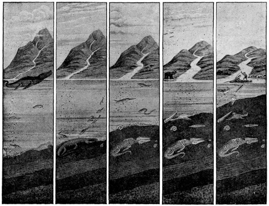
HOW THE HISTORY OF THE EARTH IS EMBEDDED IN THE ROCKS
A million years ago, a little stream trickled down a mountain-side, carrying with it grains of sand and stones which fell to the bottom of the sea. In the sea swam a great and wonderful creature called an ichthyosaurus. One day the great creature died, or probably it was killed in battle with another strange monster, and its body fell to the bottom of the sea among the shells and seaweed. Meanwhile, the stones and sand brought down by the stream continued to fall upon the bed of the sea until at last the great reptile’s body was buried, and the lower layers became pressed into hard rock by the weight on top. One day an elephant going to the river to drink broke off his tusk, and this was carried down by the river and sank in the sea. Another day a bird was drowned, and this, too, fell upon the ocean-bed. Dead fishes and shells also sank, and all were buried by the never-ceasing shower of mud and earth and sand and stones. Ages after the ichthyosaurus died, men began to live on the earth, and one day a man who had made a boat went out to fish. Trying to spear a big fish, the head of his harpoon broke off and fell to the bottom of the sea. In course of time this also was buried in the mud. The bottom of the sea crept higher and higher, till at last it became dry land. Then one day men began to dig, and the world’s wonderful story was revealed as we read it here. First the spear-head was found, then the tusk, the bird’s skeleton, the shells, the fish, and at last the skeleton of the great sea reptile, all turned to stone and become fossils, a word that means “something dug up.”
The greater number of these beds contain organic remains, i. e., the remains of animals and plants, which are termed fossils. Among these the most numerous are the remains of marine animals, and in some instances shells and corals occur in such abundance as to form the principal part of extensive beds. Every part of the earth exhibits similar, or nearly similar formations; and not only are marine fossils met with in the interior of continents, and at great elevations above the sea, but a vast variety of plants, corals, shells, fish, reptiles, etc., are found, of species dissimilar to any at present on the land or in the waters. Besides rocks, we meet with earthy formations on the surface. These include such loose materials as are disintegrated or worn away from rocks, and form, when combined with decayed animal and vegetable matter, the soil of meadows and arable lands.
Igneous, or Unstratified Rocks are such as appear to be of igneous origin, or to have been formed by the action of fire or intense heat. They are called unstratified, because instead of having been deposited in successive layers, like the stratified rocks, they seem to have been formed by the fusion or melting of the materials of which they are composed, and the subsequent cooling and hardening of the melted matter into one great mass. Granite, basalt, lava, etc., are examples of this class of rocks, and represent respectively the sub-classes of plutonic, trap, and volcanic rocks. Plutonic rocks are those which have cooled under the pressure of overlying rocks; trap rocks, those which have cooled under that of deep water; and volcanic rocks, such as have cooled in the air.
Though granite is the most useful of the igneous rocks, basalt is probably the most interesting because of the wonderful formations it discloses. It is a dense basic lava of a dark color, that breaks with a conchoidal or shell-like fracture, and shows a finely grained or hemi-crystalline texture in a glassy base. The basalt rocks are found both as intrusive masses and as sheets that have been poured out on the surface. Many of these lava sheets of basalt in slowly cooling and solidifying acquired a columnar structure, the columns often having a more or less hexagonal shape, though the number of sides varies. Fine examples of these columnar basalts occur at Fingal’s cave in the island of Staffa, at the Giant’s Causeway in the north of Ireland, and on the shores of Lake Superior.
Metamorphic, or Transformed rocks, include altered rocks of either sedimentary or igneous origin, in which the acquired are more prominent than the original characteristics. Igneous rocks have, in many cases, forced their way up through stratified rocks. These igneous formations, while still in a molten state, in coming in contact with the aqueous or stratified rocks, have usually changed the character of those portions immediately near them. The chief changes of structure effected by metamorphic action are crystallization and foliation. Examples of metamorphic rocks are marble, quartzite, slate, gneiss, and the schists.
HOW THE METALS ARE FOUND
In some localities fissures in rocks are found to contain metallic substances. Such fissures are frequently found partially filled with calcareous spar which forms the matrix in which the metals are inclosed.
Metallic veins are supposed to be partially filled by mechanical means, the particles of metallic substances being conveyed into them by the action of water or some other power, and partly by chemical action, or by sublimation or fumes rising from below.
Some metallic deposits appear to occur in situations where igneous rocks have intruded themselves. Gold is supposed to be found almost invariably under such circumstances. Such appears to be the case in the rich deposits near the Ural mountains, and also in California and in Australia. In all these places it is met with in quartz. It is in pebbles or sand of the same rock that it occurs in the beds of rivers, and in some cases is found spread over a large extent of country.
Copper, though frequently met with in veins, is also found in extensive masses or beds, interposed between layers of rock. The same remark applies to tin, lead, and silver. Iron is also met with in beds, and also in nodules or rounded masses, which occur in great abundance among some kinds of rock. The last-named is the most universally diffused of all metals, and the most useful.
A GEOLOGICAL VIEW OF THE GROWTH OF THE EARTH
Giving the geological ages, rock systems, strata and the development of life, with their relative positions and order of succession, according to the latest scientific knowledge. Many attempts have been made to compute from geological, physical, and other data the length of the period during which the earth has been in a solid state.
Geologists, however, are disinclined to accept any period much less than 100,000,000 years as sufficient for the elaboration of the present structure of the earth. It is indisputable that many millions of years, probably thirty or forty, must have elapsed while the great sedimentary rocks were being deposited. With respect to the larger features of the earth’s surface, it is likely that two different kinds of movement are responsible. Where the contraction of the earth has caused a lessening of the support below the surface, there has been a subsidence of great areas. In the second place, where the rigid crust has been able to contract into a smaller space, great mountain ridges and folds have been formed. The subsidences which caused the ocean took place at different ages. The Atlantic Ocean probably dates from middle Cenozoic times; the Indian Ocean may be older; the Pacific suffered great modifications in comparatively recent times.
Life Ages of the Earth Rock Systems Series of Rock Strata Characteristic Rocks Forms of Life Chief Economic Products
Cenozoic (se´nō-zō´ik), or “Recent life.” Estimated Age of Period, 3,000,000 years. Quaternary (kwa-ter´na-ri) or “fourth.” Once supposed to be the fourth sedimentary system. Age of man. Recent, or Human. Alluvium, sand, gravel, mud, clay, marl, loess. Man predominant. Clay, peat, bog iron ore, marl, gold placers.
Pleistocene (plīs´tŏ-sēn), or “most recent.” Glacial Period. Drift, boulder clay, gravel, loess, silt, glacial deposits and other formations formed during glacial period. Mammoth, mastodon, bear, bison, reindeer, musk-ox. Possibly man was living but that is uncertain. Clay, gravel, gold placers.
Pliocene (plī´ō-sēn), or “more recent.” In East and West, land deposits predominate. Marine sands, clays, marls on Atlantic and Pacific coasts. Igneous rocks in West. Plants and animals much as today, aside from human and domestic species. Gold (in part placers), coal, oil, gas.
Tertiary (ter´-shi-a-ri), or “third”. Once supposed to be the third sedimentary system, or Age of mammals. Miocene (mī´ō-sēn), or “less recent.” On Atlantic coast: sand, clay, shell marl, diatomaceous earth. In West: sandstone, shale, and diatomaceous material. Extensive volcanic formations in Rocky Mountains and Great Basin region. Land animals include elephants, camels, deer, oxen, horses, true apes, etc. Marine animals much like those today. Among plants, grasses become important; deciduous trees increase. Silver, gold, coal, oil, gas, phosphate rock, diatomaceous earth.
Oligocene (ŏl´ĕ-gō-sēn), or “a little more recent.” Limestone in Caribbean region, land deposits in West. Marine and fresh water beds on west coast. Many coal beds in Puget Sound. Ancient dogs, cats, rabbits, squirrels, camels, and horses were represented. Copper, silver.
Eocene (ē´-ō-sēn), or “dawn of recent.” In Eastern States: clays, sands, greensand marls. In West: conglomerate, sandstone, shale, diatomaceous shale and igneous formations are developed. Many coal beds in Puget Sound. Fresh water beds in western interior. Mammals flourished, including rodentia, carnivera, edentates, lemuroids, birds, reptiles, etc. Flora included figs, palms, bananas; willows, chestnuts, oaks, etc. Gold, zinc, lead, coal, oil, gas.
Mesozoic (mĕs-ō-zō´-ic), or “Middle life,” Estimated Age of Period, 9,000,000 years. Cretaceous (krē-ta´-she-us) or “bearing chalk.” - Upper. In East: sand, clay, and greensand marl. In West: sandstone, shale, limestone, chalk, extensive coal beds, various igneous rocks. Reptiles predominate: turtles, lizards, crocodiles, flying reptiles, etc. Many waterbirds. Angiosperms predominate: larch, beech, walnut, tulip trees, etc. Coal, oil, gas, copper, gold, china clay, fire clay, cement building stone.
Lower. Clay, sand, gravel on Atlantic coast and Gulf. Sedimentary and igneous rocks on west coast. Some non-marine beds in Texas. Reptiles abound. Flora includes cycadeous, conifers, horsetails; angiosperms appear.
Jurassic (jȯȯ-ras´sik), or like the mass of the Jura Mountains. Age of Reptiles. - Upper. Probably not represented in East. Sandstones, limestones and shales in West. Some “red beds” in western interior. Ammonites, belemites continue in great variety. Reptiles numerous and varied types. Flying reptiles and reptile-like birds appear. Oil, gold.
Middle.
Lower.
Triassic (trĭ-ăs´ĭk), or in a triple series. - Upper. In East sediments formed in shallow troughs between recently formed mountains. Considerable bodies of igneous rock, traps, and other flows and dikes. “Red beds” in West with salt and gypsum. Some igneous rocks on west coast. Reptiles of enormous size dominate the land and sea. Mammals appear. Ammonites and belemites dominate invertebrate life. Salt, gypsum, a little coal in Virginia, copper, building stone.
Middle.
Lower.
Paleozoic (pāl-æ-ô-zō´ic), or “Old life.” Estimated Age of Period, 24,000,000 years. Carboniferous (kăr-bŏn-if´-er-us), or coal-bearing. Age of Amphibians. Permian (per´-mē-ăn), like those at Perm, Russia. In East fresh water sediments including coal; in West “red beds” probably of continental origin. Some marine sediments; salt and gypsum in red beds in Kansas. Reptiles become prominent in number and variety; inhabit fresh water, salt water and land. Salt and gypsum; some coal in Eastern States.
Pennsylvanian, like those of Pennsylvania. In Eastern States grits, sandstones, shales, limestone and coal. In Western States much limestone; no coal. Igneous rocks on west coast. Plants abound; Marked development of land animals, including insects, spiders and scorpions. Lizards become important. Amphibians reach climax. Coal, oil, gas, iron ore, fire clay, phosphate rock.
Mississippian, or Lower Carboniferous. Limestones predominate with sandstones near base and shales near top of series. Igneous rocks in California. Crinoids greatly developed. Amphibians appear. Plant life expands. Oil, gas, lead, zinc, building stone, cement rock.
Devonian (de-vō´ni-an) like those of Devonshire, England. Age of Fishes. - Upper. Sedimentary rocks, limestones, sandstones, shales; igneous rocks in Maine, Nova Scotia, and New Brunswick. Rapid changes in animal kingdom; shifting habitat; extensive development of fishes; sharks flourish. Plants are mainly small leaf and reed types. Gas, oil, iron ore, phosphate rock.
Middle.
Lower.
Silurian (si-lū´ri-an), in the land of the Silures, England. Age of Invertebrates. - Ontarian (on-tā´rē-ăn), place name. Sedimentary rocks predominate; conglomerates, sandstones, shales, limestones, salt, gypsum. Igneous rocks in Nova Scotia, New Brunswick, and Maine. Vertebrates appear; low forms of fishes. First reef building corals. Crinoids and brachiopods, important Cephalopods continue to dominate. Iron ore, gas, salt, gypsum, cement rock.
Champlainian (shăm-plān´ē-ăn), place name.
Ordovician (ŏr-dŏ-vīsh´ăn), a place name in Wales. - Cincinnatian (sĭn-sĭn-năt´-ē-ăn), place name. Chiefly limestone with subordinate sandstone and shale. Rocks greatly folded in New York, in Taconic Mountain region. Much as in the Cambrian. Remains are more abundant. Species more numerous; insects were present. Vertebrates appear. Low forms of fishes. Trilobites reach climax. Oil, gas, lead, zinc, phosphate rock, manganese, marble.
Mohawkian (mō-hŏk´ē-ăn), place name.
Lower.
Cambrian (kam´-bri-an), from Cambria, the old name for Wales. - Saratogan (săr-ă-tō´găn), place name. Mainly sandstones with some shales, and in Western States considerable limestone. At some places rocks are changed by pressure, especially in the Appalachian Mountains. Upper Cambrian covered larger area than lower Cambrian. All great divisions of animal kingdom except vertebrates are represented; trilobites, brachiopods, sponges, graptolites, etc. Little evidence of vegetation, but it must have abounded as food for animals. Lead, zinc, barite, copper.
Acadian (ä-kād´ē-ăn), place name.
Georgian (jōr´gē-ăn), place name.
Proterozoic (prō-ter-ō-zō´ik) or “Former life.” Estimated Age of Period, 18,000,000 years. Algonkian (ăl-gŏn´kē-ăn), from district of Algonquin Indians, north of St. Lawrence. - Keweenawan, (kē´wē-năh-wān), pertaining to Keweenaw Peninsula, Michigan. A great series of sandstones, limestones and shales, in middle portion of which are many enormous flows of lava. Fossils rare or wanting. Copper, silver.
Huronian (hu-rō´nē-ăn), rocks on borders of Lake Huron. Three great series of sedimentary rocks, sandstone, shale and limestone, and iron formation. Contains also many great igneous bodies, acidic and basic. Lower members much metamorphosed by pressure. Rocks contain clear evidence of low forms of life. Principal iron ores of Lake Superior region; also copper, nickel, silver, cobalt, gold. Building stone and ornamental stone.
Archaeozoic (ar´kē-o-zō´ic), “Without life.” Estimated Age of Period, 18,000,000 years. Archean (är-kē´-ăn), “oldest.” - Laurentian (law-ren´shi-an), pertaining to rocks along the St. Lawrence River. Granitic rocks and gneisses that are believed to be granitic rocks metamorphosed by pressure. Formerly supposed to be older than Keewatin and regarded as the “original crust of the earth.” Since the rocks are of igneous origin, they contain no organic remains. Iron ores, precious metals, gems, apatite, rare earths, graphite, asbestos.
Keewatin (kē-wā´tĭn), rocks in a district of Manitoba, Canada. A great schist series made up of lava flows, tuffs, and volcanic ashes. With these are subordinate sedimentary rocks; sandstone, shale, limestone, and iron ore formations nearly everywhere greatly metamorphosed by pressure. Includes the oldest rocks known. No fossils found, but carbonaceous schists and limestones are believed to indicate the presence of life. Emery, building and ornamental stones.
Life Ages of the Earth Rock Systems Series of Rock Strata Characteristic Rocks Forms of Life Chief Economic Products
Cenozoic (se´nō-zō´ik), or “Recent life.” Estimated Age of Period, 3,000,000 years. Quaternary (kwa-ter´na-ri) or “fourth.” Once supposed to be the fourth sedimentary system. Age of man. Recent, or Human. Alluvium, sand, gravel, mud, clay, marl, loess. Man predominant. Clay, peat, bog iron ore, marl, gold placers.
Pleistocene (plīs´tŏ-sēn), or “most recent.” Glacial Period. Drift, boulder clay, gravel, loess, silt, glacial deposits and other formations formed during glacial period. Mammoth, mastodon, bear, bison, reindeer, musk-ox. Possibly man was living but that is uncertain. Clay, gravel, gold placers.
Pliocene (plī´ō-sēn), or “more recent.” In East and West, land deposits predominate. Marine sands, clays, marls on Atlantic and Pacific coasts. Igneous rocks in West. Plants and animals much as today, aside from human and domestic species. Gold (in part placers), coal, oil, gas.
Tertiary (ter´-shi-a-ri), or “third”. Once supposed to be the third sedimentary system, or Age of mammals. Miocene (mī´ō-sēn), or “less recent.” On Atlantic coast: sand, clay, shell marl, diatomaceous earth. In West: sandstone, shale, and diatomaceous material. Extensive volcanic formations in Rocky Mountains and Great Basin region. Land animals include elephants, camels, deer, oxen, horses, true apes, etc. Marine animals much like those today. Among plants, grasses become important; deciduous trees increase. Silver, gold, coal, oil, gas, phosphate rock, diatomaceous earth.
Oligocene (ōl´ĕ-gō-sēn), or “a little more recent.” Limestone in Caribbean region, land deposits in West. Marine and fresh water beds on west coast. Many coal beds in Puget Sound. Ancient dogs, cat, rabbits, squirrels, camels, and horses were represented. Copper, silver.
Eocene (ē´-ō-sēn), or “dawn of recent.” In Eastern States: clays, sands, greensand marls. In West: conglomerate, sandstone, shale, diatomaceous shale and igneous formations are developed. Many coal beds in Puget Sound. Fresh water beds in western interior. Mammals flourished, including rodentia, carnivera, edentates, lemuroids, birds, reptiles, etc. Flora included figs, palms, bananas; willows, chestnuts, oaks, etc. Gold, zinc, lead, coal, oil, gas.
Mesozoic (mĕs-ō-zō´-ic), or “Middle Life.” Estimated Age of Period, 5,000,000 years. Cretaceous (krē-ta´-she-us) or “bearing chalk.” - Upper. In East: sand, clay, and greensand marl. In West: sandstone, shale, limestone, chalk, extensive coal beds, various igneous rocks. Reptiles predominate: turtles, lizards, crocodiles, flying reptiles, etc. Many waterbirds. Angiosperms predominate: larch, beech, walnut, tulip trees, etc. Coal, oil, gas, copper, gold, china clay, fire clay, cement building stone.
Lower. Clay, sand, gravel on Atlantic coast and Gulf. Sedimentary and igneous rocks on west coast. Some non-marine beds in Texas. Reptiles abound. Flora includes cycadeous, conifers, horsetails; angiosperms appear.
Jurassic (jȯȯ-ras´sik), or like the mass of the Jura Mountains. Age of Reptiles. - Upper. Probably not represented in East. Sandstones, limestones and shales in West. Some “red beds” in western interior. Ammonites, belemites continue in great variety. Reptiles numerous and varied types. Flying reptiles and reptile-like birds appear. Oil, gold.
Middle.
Lower.
Triassic (trĭ-ăs´ĭk), or in a triple series. - Upper. In East sediments formed in shallow troughs between recently formed mountains. Considerable bodies of igneous rock, traps, and other flows and dikes. “Red beds” in West with salt and gypsum. Some igneous rocks on west coast. Reptiles of enormous size dominate the land and sea. Mammals appear. Ammonites and belemites dominate invertebrate life. Salt, gypsum, a little coal in Virginia, copper, building stone.
Middle.
Lower.
Paleozoic (pāl-æ-ô-zō´ic), or “Old Life.” Estimated Age of Period, 24,000,000 years. Carboniferous (kăr-bŏn-if´-er-us), or coal-bearing. Age of Amphibians. Permian (per´-mē-ăn), like those at Perm, Russia. In East fresh water sediments including coal; in West “red beds” probably of continental origin. Some marine sediments; salt and gypsum in red beds in Kansas. Reptiles become prominent in number and variety; inhabit fresh water, salt water and land. Salt and gypsum; some coal in Eastern States.
Pennsylvanian, like those of Pennsylvania. In Eastern States grits, sandstones, shales, limestone and coal. In Western States much limestone; no coal. Igneous rocks on west coast. Plants abound. Marked development of land animals, including insects, spiders and scorpions. Lizards become important. Amphibians reach climax. Coal, oil, gas, iron ore, fire clay, phosphate rock.
Mississippian, or Lower Carboniferous. Limestones predominate with sandstones near base and shales near top of series. Igneous rocks in California. Crinoids greatly developed. Amphibians appear. Plant life expands. Oil, gas, lead, zinc, building stone, cement rock.
Devonian (de-vō´ni-an) like those of Devonshire, England. Age of Fishes. - Upper. Sedimentary rocks, limestones, sandstones, shales; igneous rocks in Maine, Nova Scotia, and New Brunswick. Rapid changes in animal kingdom; shifting habitat; extensive development of fishes; sharks flourish. Plants are mainly small leaf and reed types. Gas, oil, iron ore, phosphate rock.
Middle.
Lower.
Silurian (si-lū´ri-an), in the land of the Silures, England. Age of Invertebrates. - Ontarian (on-tā´rē-ăn), place name. Sedimentary rocks predominate; conglomerates, sandstones, shales, limestones, salt, gypsum. Igneous rocks in Nova Scotia, New Brunswick, and Maine. Vertebrates appear; low forms of fishes. First reef building corals. Crinoids and brachiopods, important Cephalopods continue to dominate. Iron ore, gas, salt, gypsum, cement rock.
Champlainian (shăm-plān´ē-ăn), place name.
Ordovician (ŏr-dŏ-vīsh´ăn), a place name in Wales. - Cincinnatian (sĭn-sĭn-năt´-ē-ăn), place name. Chiefly limestone with subordinate sandstone and shale. Rocks greatly folded in New York, in Taconic Mountain region. Much as in the Cambrian. Remains are more abundant. Species more numerous; insects were present. Vertebrates appear. Low forms of fishes. Trilobites reach climax. Oil, gas, lead, zinc, phosphate rock, manganese, marble.
Mohawkian (mō-hŏk´ē-ăn), place name.
Lower.
Cambrian (kam´-bri-an), from Cambria, the old name for Wales. - Saratogan (săr-ă-tō´găn), place name. Mainly sandstones with some shales, and in Western States considerable limestone. At some places rocks are changed by pressure, especially in the Appalachian Mountains. Upper Cambrian covered larger area than lower Cambrian. All great divisions of animal kingdom except vertebrates are represented; trilobites, brachiopods, sponges, graptolites, etc. Little evidence of vegetation, but it must have abounded as food for animals. Lead, zinc, barite, copper.
Acadian (ä-kād´ē-ăn), place name.
Georgian (jōr´gē-ăn), place name.
Proterozoic (prō-ter-ō-zō´ik) or “Former Life.” Estimated Age of Period, 18,000,000 years. Algonkian (ăl-gŏn´kē-ăn), from district of Algonquin Indians, north of St. Lawrence. - Keweenawan, (kē´wē-năh-wān), pertaining to Keweenaw Peninsula, Michigan A great series of sandstones, limestones and shales, in middle portion of which are many enormous flows of lava. Fossils rare or wanting. Copper, silver.
Huronian (hu-rō´nē-ăn), rocks on borders of Lake Huron. Three great series of sedimentary rocks, sandstone, shale and limestone, and iron formation. Contains also many great igneous bodies, acidic and basic. Lower members much metamorphosed by pressure. Rocks contain clear evidence of low forms of life. Principal iron ores of Lake Superior region; also copper, nickel, silver, cobalt, gold. Building stone and ornamental stone.
Archaeozoic (ar´kē-o-zō´ic), “Without Life.” Estimated Age of Period, 18,000,000 years. Archean (är-kē´-ăn), “oldest.” - Laurentian (law-ren´shi-an), pertaining to rocks along the St. Lawrence River. Granitic rocks and gneisses that are believed to be granitic rocks metamorphosed by pressure. Formerly supposed to be older than Keewatin and regarded as the “original crust of the earth.” Since the rocks are of igneous origin, they contain no organic remains. Iron ores, precious metals, gems, apatite, rare earths, graphite, asbestos.
Keewatin (kē-wā´tĭn), rocks in a district of Manitoba, Canada. A great schist series made up of lava flows, tuffs, and volcanic ashes. With these are subordinate sedimentary rocks; sandstone, shale, limestone, and iron ore formations nearly everywhere greatly metamorphosed by pressure. Includes the oldest rocks known. No fossils found, but carbonaceous schists and limestones are believed to indicate the presence of life. Emery, building and ornamental stones.
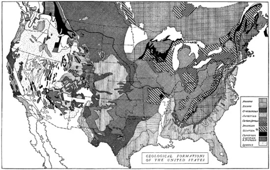
GEOLOGICAL MAP OF THE UNITED STATES SHOWING THE REGIONS OF REPRESENTATIVE FORMATIONS
Large illustration (310 kB)
THE SURFACE OF THE EARTH
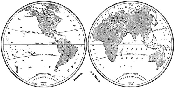
MAP SHOWING THE DISTRIBUTION OF LAND AND WATER
Large illustration (222 kB)
LAND FORMS OF THE WORLD
The proportion of land to water upon the earth is as 27 to 72, or roughly one-fourth to three-fourths; the land covering fifty-three million square miles, the sea one hundred and forty-four million. The land consists of six great bodies called continents, and a multitude of small fragments called islands, which skirt the shores of the continents or dot the broad expanse of the sea.
THE DISTRIBUTION OF LAND AND WATER
By far the greatest proportion of land is in the northern hemisphere, and in temperate latitudes. Broadly speaking, the northern hemisphere is the hemisphere of land, and the southern hemisphere is the hemisphere of ocean. The earth could be bisected in such a way that one hemisphere contained almost no land, while the other was composed almost equally of land and water.
LOCATION OF THE CONTINENTS
The greater part of the land on the earth’s surface is grouped into two great hemispheres, the Old and the New World. The former and far larger of these consists of Eurasia in the north, separated by ill-defined boundaries from Europe to the west and Asia to the east, and of Africa in the south, united to Eurasia by the narrow neck of the isthmus of Suez. The hemisphere of the New World is divided into North America and South America, united by the long, narrow isthmus of Central America. The island of Australia is also reckoned as a continent. It is believed that an island continent, Antarctica, surrounds the South Pole. Of islands not reckoned as continents, the largest is the polar island of Greenland.
CERTAIN RESEMBLANCES OF THE CONTINENTS
In comparing the continents, we at once notice certain resemblances. The first is the tapering to the south, which is seen in Greenland, North and South America, Africa, and Australia (Tasmania). Another is the southward-running peninsulas which characterize Europe and Asia. We may notice, too, that the general lines of the Old World, broad in the north, tapering in the south, resemble those of the New World, especially if we include Australia (Tasmania), and compare its position with that of South America. There is also a certain uniformity in the distribution of relief. Notice the so-called Mid-World and Pacific Mountain systems, which may be traced in the mountains of Central Europe, North Africa, Central Asia, the islands of the Pacific from Japan to New Guinea, and the lofty mountains of North, Central, and South America.
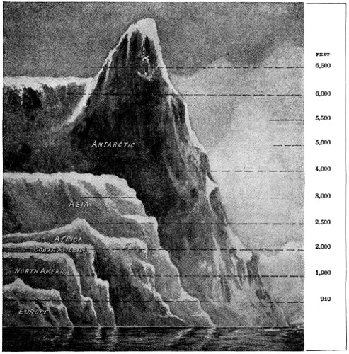
DIAGRAM SHOWING AVERAGE HEIGHT OF THE CONTINENTS
COMPARISON OF THE CONTINENTS
Continent Asia Africa North America South America Europe Australia All Land
Area (million square miles) 16 .4 11 .1 7 .6 6 .8 3 .7 3 .0 55 .0
Average Height (feet) 3, 000 2, 500 1, 900 2, 000 940 800 2, 100
Highest Point (feet) 29, 000 18, 800 18, 200 22, 400 18, 500 7, 200 29, 000
Percentage at Various Altitudes (feet)
Below Sea-Level 1 .4 0 .1 0 .05 0 .0 1 .8 0 .0 0 .6
0 to 600 feet 23 .3 12 .5 32 .25 40 .0 53 .8 29 .8 26 .7
600 to 1,500 feet 16 .0 34 .8 32 .1 26 .8 27 .0 64 .3 27 .8
1,500 to 3,000 feet 21 .7 27 .6 13 .3 16 .8 10 .0 4 .1 19 .3
3,000 to 6,000 feet 21 .8 21 .8 13 .2 7 .0 5 .5 1 .5 17 .0
6,000 to 12,000 feet 10 .0 2 .8 8 .4 5 .0 1 .7 0 .3 6 .0
Above 12,000 feet 5 .8 0 .4 0 .7 4 .4 0 .2 0 .0 2 .6
THE SHAPING OF THE COAST
The coast line, or margin of sea and land, is an area rapidly wearing away under the ceaseless influence of the waves, and of the sand and rock, they are perpetually hurling to and fro. Coasts may be either flat or high, composed either of hard or soft rock, and either submerged or raised. A submerged coast is one where the land has sunk or the sea has risen, so that the low grounds and valleys are flooded. A raised coast is one where the land has risen or the sea has retired, and what was formerly the sea bottom is bared.
A flat coast is usually sandy, often bordered by sandhills and lagoons. It may be carved into cliffs, as in the clay cliffs of Norfolk, England. A raised coast is usually flat from the long-continued action of the waves during the period when it was submerged. Flat coasts have no good harbors.
A submerged coast differs according to the nature of the submerged region. If this was hilly or mountainous, with valleys running parallel to the shore, the coast will be ironbound and harbor-less unless the sea-level has risen sufficiently to give access to the valleys behind the first range of heights. If this happens, T-shaped gulfs are formed. Where the valleys open at right angles to the sea, they become bays, usually with excellent harbors. The hills between the valleys rise as peninsulas, or islands. If the land was flat before submerging took place, a flat coast is the result.
Where the land is composed of soft rocks, a more uniform coast-line results than where it is composed of harder rocks, or of hard and soft rocks mixed. The waves, in eating out the softer rocks, often form magnificent sea-caves, natural arches, and pinnacles.
THE COASTLINE OF THE VARIOUS CONTINENTS
Europe surpasses all the other continents in the magnitude of its indentations and projections. Three great peninsulas—the Balkan peninsula, Italy, and Spain, project into the Mediterranean; while Brittany, Denmark, and Scandinavia jut into the shores of the Atlantic. Even the British Isles are scarcely more than a projection of the continent.
Asia is a second in the relative extent of its peninsula. Asia Minor on the west, Arabia, India, and Indo-China on the south, and China, Manchuria with Corea and Kamchatka, advancing into the waters of the Pacific, form a wide border of projecting lands, containing the richest regions of the continent.
North America is considerably less indented. Florida, Nova Scotia and Labrador are more prominent on the Atlantic coast, and California Peninsula and Alaska on the Pacific.
The southern continents on the contrary, are nowhere deeply penetrated by the waters of the ocean. The Gulf of Arica in South America, the Gulf of Guinea in Africa, and the Great Australian Bight, are merely gentle bends in the coast line.
LOCATION OF THE GREAT PLAINS OF THE WORLD
Plains occupy nearly one-half of the surface of the continents. They are most extensive and unbroken on the Arctic slopes of the Old World, and in the interior of the two Americas.
Treeless plains, whose vegetation consists of grasses and other herbaceous plants, or stunted shrubs, occur in every continent, and are designated by a variety of terms. Wherever treeless plains are subject to periodical rains, they lose their verdure in the season of drought, and assume the aspect of a desert; but they resume their freshness on the return of the rain, and many are adorned with a great variety of beautiful flowers.
Plains of the Old World. The great Siberian plain extends from the northeastern extremity of Asia to the Ural Mountains and Caspian Sea; and the European plain stretches from the Ural westward, through Russia and North Germany, to the lowlands of Holland.
The plains of the Caspian Sea and western Siberia are dreary steppes, covered with coarse grasses, often growing in tufts, alternating with patches of heather, furze, dwarf birch, and other stunted shrubs; or old sea bottom, covered with salt efflorescence. Immense reaches of flat country, near the Arctic shores of Asia and Europe, consist of frozen marshes, called tundras, where mosses and lichens are almost the only vegetation. Those of eastern Europe and Asia are denominated steppes; while more limited treeless regions in western Europe are called landes and heaths.
On the alluvial plains of the Old World, civilization began and developed; and their inexhaustible fertility supplied the wants of the most populous nations of antiquity. The great centers of ancient civilization in Egypt, China, India and Babylonia, all had their growth in alluvial plains, built up and fertilized by the mighty rivers which traverse those countries.
Plains of the New World. In North America the great Central Plain extends, with but slight interruptions, from the Arctic shores to the Gulf of Mexico. The fertile, treeless plains are termed “prairies” (meadows), while the sterile ones, east of the Rocky Mountains, are known as “the plains.” There are vast cane fields and forests in the lower Mississippi Valley.
In South America the plains of the Orinoco basin, the Selvas of the Amazon, and the Pampas of the La Plata, form an uninterrupted series of lowlands which, continued by the plains of Patagonia to the southern extremity of the continent, extend over a distance of three thousand five hundred miles from north to south. The Spanish term “llano” (plain), and the Peruvian “pampa,” designate the treeless plains of the Orinoco and La Plata basins. The Llanos of the Orinoco, during one-half of the year are covered by the richest pasturage, bright with flowers, but during the other half are a parched waste. The Selvas of the Amazon, a luxuriant forest, cover more than a million square miles; and the treeless Pampas, with their tall grasses and thickets of clover and thistles, illustrate the endless richness and variety of nature.
Alluvial and marine plains generally have but a slight altitude, while the undulating plains are sometimes considerably elevated. The Mississippi Valley, at St. Louis, one thousand miles from the ocean, is hardly four hundred feet above the sea-level; and the Amazon, at an equal distance from the sea, does not reach two hundred and fifty feet. The marine plains adjacent to the Caspian and Aral seas are still lower, the larger portion being below the sea-level.
SITUATION, ELEVATION AND SOIL OF PLATEAUS
Plateaus are situated either between two lofty mountain chains, which form their margins, or descend by successive terraces to the nearest seas; or they pass, by gradations, from the base of high mountains to the low plains in the interior of the continents.
The Great American Basin, between the Rocky and Sierra Nevada Mountains, and the plateau of Tibet, between the Himalaya and Kuenlun mountains, are examples of the first position; and the table-land of Mexico, of the second. The third is seen in the high plains at the eastern foot of the Rocky Mountains, which descend from an altitude of five thousand or six thousand feet, at the foot of the mountains, to the low plains of the Mississippi basin.
The plateaus most remarkable for their elevation are, Tibet, from ten thousand to eighteen thousand feet above the sea; and the elongated valley-like highlands, from ten thousand to thirteen thousand feet high, between the two chains of the Andes, in South America. East Turkestan and Mongolia, in central Asia; the plateau of Iran, in western Asia; Abyssinia, and the vast plateau which occupies all the southern part of Africa; and the broad table-land which fills the western half of North America with a continuous mass of high land, range in height from four thousand to eight thousand feet.
The great peninsulas of Deccan, Arabia, Asia-Minor and Spain, the central plateau of France, and those of Switzerland, Bavaria, and Transylvania, vary from one thousand to four thousand feet in elevation.
SOIL AND CLIMATE OF PLATEAUS
The nature of the soil and climate of great plateaus is in general such as to render them the least useful portions of the continents. Sahara, with an average altitude of 1,000 feet, and the higher plateaus of Mongolia, Iran and parts of the American Basin, may serve as types.
Their surface consists of hardened sand and rock; of hillocks and plains of loose sand constantly shifting by the wind; and of immense tracts, as in Mongolia, covered with pebbles varying from the size of a walnut, or even less, to a foot in diameter: all indicating the original transporting, grinding and depositing of these materials by water.
Salt lakes without outlet occur in each, and salt efflorescence often covers the ground. A lack of rain to wash from the soil substances injurious to vegetation, and supply the water necessary for the growth of plants, leaves these plateaus generally sterile, and some of the most extensive are in part, if not wholly, deserts.
MOUNTAINS AND THEIR STRUCTURES
Mountains rise in long and comparatively narrow lines or ridges, the tops of which are often deeply indented, presenting to the eye the appearance of a series of peaks detached one from another. As each of these peaks or distinct elevations is called a mountain and often receives a separate name, the common designation chain or range of mountains is naturally applied to the whole.
The top of the ridge, from which the waters descend on opposite sides, is called the crest; and the notches between the peaks, from which transverse valleys often stretch like deep furrows down the slopes of the chain, are called passes.
HOW MOUNTAIN CHAINS FORM SYSTEMS
Mountain chains are seldom isolated, but are usually combined into systems, consisting of several more or less parallel and connected chains, with their intervening valleys,—as the Appalachian system, the Alps, and the Andes.
Most mountain chains seem to have been produced by tremendous lateral pressure in portions of the Earth’s crust, causing either long folds, or deep fissures with upturned edges rising into high ridges, the broken strata forming ragged peaks.
TWO TYPES OF MOUNTAIN CHAINS
Mountains by folding are generally of moderate elevation, while mountains by fracture include the highest chains of the globe. The Appalachian Mountains in North America, and the Jura in Europe, are examples of the first; the Rocky Mountains, Andes, Alps and Himalayas, of the second.
Folded mountains are curved into long arches, either entire or broken at the summit and forming a system of long, parallel ridges, of nearly equal height, separated by trough-like valleys. Here and there, however, deep gaps, or gorges, cut the chains allowing the rivers to escape from one valley to another.
In systems of mountains produced by fracture, there is usually one main central chain, with several subordinate ranges. They have, however, less regularity and similarity among themselves than the parallel chains of mountains by folding.
The crests are deeply indented, cut down one-third or one-half the height of the range, forming isolated peaks and passes which present to the eye the appearance of a saw, called in Spanish Sierra; in Portuguese, Serra. Such ranges are frequently distinguished by these terms, as the Sierra Nevada, in North America; and the Serra do Mar, in Brazil.
HOW VALLEYS ARE FORMED
Valleys among mountains owe their existence primarily to folds or fissures in the Earth’s crust, produced in the upheaving of the ranges; but they are subsequently deepened, widened and otherwise changed in form and extent, by the action of rains and frosts, and the streams to which they furnish a pathway. Most of the Alpine lakes, celebrated for their picturesque beauty, occupy deep basins at the outlet of transverse valleys.
Valleys in plains and plateaus are mainly, if not entirely, the result of the erosion, or wear of the surface, by running water.
Little rills, formed by the rains or issuing from springs, set out on their course down the slope of the ground, each wearing its small furrow in the surface. Uniting they form a rivulet which wears a broader and deeper channel; and the rivulets in turn combining, form rivers which produce still greater effects.
The great basin of the Mississippi for example, is one grand central valley, cut by the main stream in the line of lowest level, towards which the valleys of the Missouri, the Arkansas, the Ohio, and a multitude of smaller streams, all converge.
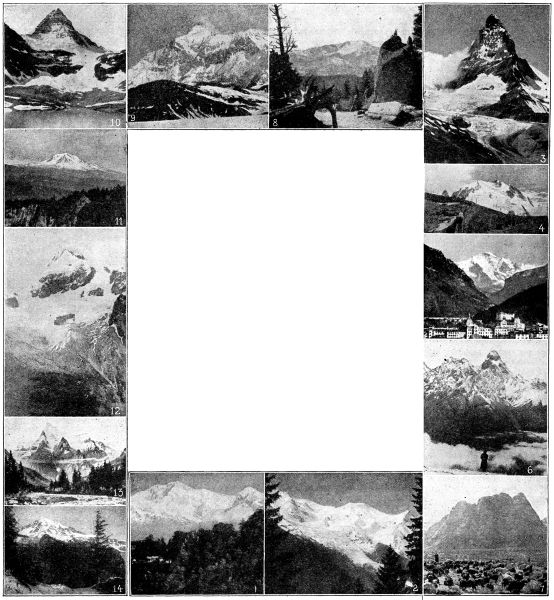
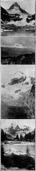
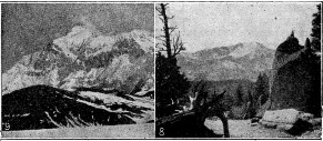
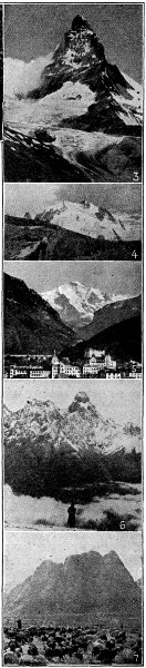
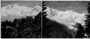
CELEBRATED MOUNTAIN PEAKS THAT STAND AS THE EARTH’S GREATEST SENTINELS
1. Mount Everest, the loftiest mountain in the world, is situated in Nepal, India, and rises to an ascertained height of 29,000 feet—almost six miles. It was named for Sir George Everest, an English engineer, and outline Surveyor-General of India. Everest is only one of numerous gigantic peaks of the Himalayas—often called the “Roof of the World”—and is apparently guarded against all attempts at ascent by a rampart of lofty pinnacles. It is best viewed from a point near Darjeeling, India, one hundred and twenty miles distant. From this point travelers are enthralled with the glistening peak of mountain piles as nowhere else on earth. Though a thousand times described, the view is so surpassingly sublime that its full glory can never be depicted in words.
2. Mont Blanc (mòn-blon-g) is the highest mountain in Europe, and of the Alps. It is located between Great and Little St. Bernard passes, on the frontier of France, Switzerland and Italy; and is best seen and approached from the village of Chamounix (shä-mo-nē´), France. It was first ascended in 1786, but frequently since, and, in 1893, an observatory was built on its summit. The Mont Blanc chain is famous for glaciers. Many great poets have described the majesty of Mont Blanc, among them, Goethe, Victor Hugo, Byron, Shelley, Wordsworth, and Coleridge.
3. The Matterhorn, or Mount Cervin, a splendid mountain obelisk, towers above Zermatt, Switzerland, on the Italian border. The eastern side seems almost vertical, and its ascent is very difficult; hence its name which is due to the formation of the rocky, horn-shaped peak. The loss of life attending its ascent has given the Matterhorn the grim name “Fatal Mountain.”
4. Monte Rosa (mŏn´te rō´sa), “rosy mountain,” is next to Mont Blanc, the highest Alpine peak. It is the border between Italy and Switzerland, sixty miles north of Turin, Switzerland. Unlike the Matterhorn, Monte Rosa is easy of ascent and is frequently climbed by ladies. Its name refers to the glaciers which abound and reflect beautiful colors.
5. Jungfrau (yung´frau), “virgin,” is one of the Bernese Alps, Switzerland, thirteen miles from Interlaken. It is so named from the pure whiteness of its snowclad peak. A wonderful mountain railway now reaches to the summit, most of the line being through tunnels. Jungfrau is 13,670 feet high.
6. Mount Elburz is one of the loftiest and most impressive of all the Caucasian mountains. It is an extinct volcano with two peaks, the western peak 18,470 feet above sea-level, and the other 18,347 feet. It is covered with glaciers, and constitutes a watershed which divides Asia from Europe. The Caucasus gave its name to that great branch of the human race that has ruled the world for many generations.
7. Mount Sinai (si´nā or -nī), famous as the sacred mountain on which Moses received the Ten Commandments, is an individual peak in a vast rocky mass that almost fills the peninsula of Sinai between the Gulf of Suez and Gulf of Akaba. It is named from Sin, the Babylonian moon-god. At its foot, in a ravine, is the monastery of St. Catherine, founded by the Emperor Justinian; a short distance from it the Chapel of St. Elias (Elijah); while on its summit is a little pilgrim church. Its height is 8,593 feet.
8. Pike’s Peak. This famous mountain is six miles from Colorado Springs, Colorado, and may be ascended by a cog railway. It is one of the best-known summits of the Rocky Mountains, and rears its snowy crest to a height of 14,134 feet. On its top is one of the highest weather stations in the world. The view from the observatory is superb, embracing thousands of square miles of mountain and plain.
9. Mount St. Elias, on the Alaskan side of the Canadian frontier, was long considered the highest peak in North America. It is a volcanic mountain, stands in a wild, inaccessible region, and is clothed almost from base to summit with eternal snow. Besides, there are huge glaciers, impassable precipices and yawning chasms. Its height is 18,020 feet. It was ascended by the Duke of the Abruzzi in 1897.
10. Mount Assiniboine (as-sin´i-boin) is frequently called the “Matterhorn of the Canadian Rockies”. It is 11,860 feet in height, and is located near the boundary of British Columbia and Alberta, about twenty miles south of Banff, in one of the most beautiful scenic regions in America. In the immediate vicinity there are geysers, caves, waterfalls, numerous lakes, natural bridges, and glaciers.
11. Mount Popocatepetl (pō-pō-kă-tā-pet´l) is one of the giant volcanic peaks standing guard over Mexico City. Its summit is perpetually covered with snow, but it may be ascended from Popo Park, the terminal of the railway which climbs its slope, to a height of 8,000 feet. The peak itself is 17,887 feet, at the apex of which is a huge crater sheathed with ice, from which clouds of vapor are continually ascending. No great eruption, however, has taken place since 1540. The most imposing spectacle of all from the summit is the remarkable formation of clouds below.
12. Mount Salcantay, one of the most beautiful peaks of the Andes, in Peru, is 21,000 feet in height. Its grandeur is enhanced by the presence of glaciers and the enveloping clouds. It rises to a sharp point with its sides covered with snow and ice, and lifts its head magnificently thousands of feet higher than the surrounding mountains. It has been recently explored by the Yale University expedition.
13. Mount Robson, the highest point in the Canadian Rockies, reaches an elevation of 13,700 feet. It is on the border between Alberta and British Columbia, one of the remarkable “show places” of the Canadian Rockies. All around it is the finest of scenery—huge mountains, snow-crested peaks, rushing rivers that swirl and foam, mysterious canyons and earth-strewn boulders.
14. Mount Rainier (rā´ner) an isolated mountain of the Cascade Range, forty miles southeast of Tacoma, Washington, is an extinct volcano, 15,529 feet in height. There are still two craters at the summit which give off heat and sulphurous fumes. Thick forests cover the lower region of the mountain, while higher up there are fourteen glaciers. It is difficult of ascent, though frequently made. A bridle path leads to a point over 7,000 feet in elevation from which a magnificent view of several of the glaciers may be had.
Mount Ararat, famed as the mountain where Noah’s ark landed after the flood, as recorded in Genesis, is in the Turkish province of Armenia. Ararat is really a twin mountain, the two peaks of which are about seven miles apart, with an elevation of about 17,000 and 13,000 feet, respectively. They rise above a beautiful alluvial plain, and quite naturally the higher peak—Great Ararat—is the one made historically immortal as the motherland of the human race. From their isolation and bareness the two peaks are very impressive, and it is little wonder that Armenia regards these mountain tops as a crown of glory and all other lands as her daughters. Within her borders, too, she gives rise to the beautiful rivers Euphrates, Tigris, Pison, Araxes, and many others. The first modern ascent of the mountain was made in 1829, though often since.
REMARKABLE CANONS OF THE ROCKY MOUNTAIN PLATEAUS
Wonderful examples of valleys by erosion occur in the plateaus adjacent to the Rocky Mountains. The Grand Canon of the Colorado, three hundred miles long, has a depth of from three thousand to six thousand feet below the surrounding country. The sides of this tremendous gorge, which are nearly or quite precipitous, exhibit the successive geological strata down to the oldest rocks. A similar formation exists in the upper course of the Yellowstone, one of the main tributaries of the Missouri, and to a less extent in all the streams flowing through the high barren plateaus.
Valleys descending the slopes of mountains are formed in the same manner. The gathering drops make the rill, and the rill its little furrow; rills combine into rivulets, and rivulets make a gully down the hill-side; rivulets unite to form torrents, and these work with accumulating force, and excavate deep gorges in the declivities. Other torrents form in the same manner about the mountain ridge, and pursue the same work of erosion until the slopes are a series of valleys and ridges, and the summit a bold crest overlooking the eroding waters. The larger part of the valleys of the world are formed entirely by running water.
ISLANDS OF THE WORLD
CONTINENTAL AND OCEANIC ISLANDS
The multitude of small and apparently fragmentary bodies of land, called islands, form only about one-seventeenth part of the entire land surface of the globe.
Continental islands are situated in the immediate vicinity of the continents, and form properly a part of the continental structure. They have the same kinds of rocks and mountain forms, and the same varieties of plants and large animals, which are found on the neighboring coasts of the mainland.
The size of this class of islands varies extremely. Some are mere isolated rocks, while others occupy large areas, like the British Isles, Japan Islands and Madagascar; or, more extensive still, Papua and Borneo, each of which has an area exceeding two hundred thousand square miles.
The distinctive character of Oceanic islands is that they lie at a distance from the continents, in the midst of the ocean basins. They are always small, and, though sometimes forming lines, or bands, they more frequently occur in groups.
The rocks which make up the body of the continents and continental islands—sandstone, slate, granite, and the various metamorphic rocks—are entirely wanting in oceanic islands. The latter are composed either of volcanic substances, or of limestone. Hence they present much less variety in relief forms than the continental islands.
FORMS OF VOLCANIC ISLANDS
The islands of volcanic origin are more or less circular in outline; are usually considerably elevated, with rapid slopes; and are of moderate size. Sometimes two or more volcanoes, clustered together, form a single island of larger size and more irregular outline.
Occasional islands rise but little above the surface of the sea, their craters being filled by sea water. Many, however, rise to Alpine heights—like the peaks of Hawaii, in the Hawaiian Islands, nearly fourteen thousand feet in elevation; Pico de Teyde, in the Canaries, fourteen thousand feet; and Tahiti, in the Society Islands, over seven thousand feet above the level of the sea.
WONDERFUL STRUCTURE OF CORAL ISLANDS
Coral islands are among the most striking phenomena of the tropical seas. Whitsunday Island in the midst of the Pacific is an excellent example. Rising but a few feet above the surface of the ocean, it forms a narrow, unbroken, nearly circular ring, surrounding a central lagoon of quiet water. When first seen, it presents the aspects of an angry surf breaking on a white beach of coral sand, in strong contrast with the deep blue color of the sea. Behind this a garland of luxuriant vegetation, whose tropical beauty, enhanced by the noble cocoa-palm encircles the quiet waters of the lagoon, while all around spreads the broad blue sea.
TWO OF THE GREATEST MARVELS OF LAND AND SEA
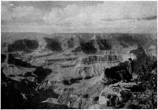
THE GRAND CANYON OF THE COLORADO RIVER, ARIZONA
This greatest of nature’s gorges is more than twelve miles across, a mile deep, and extends over two hundred miles in length. This whole vast space has been sculptured by the wear of the river through countless centuries. Its unparalleled magnitude, its architectural forms and suggestions, and its wealth of color effects create a picture that is grand beyond description.
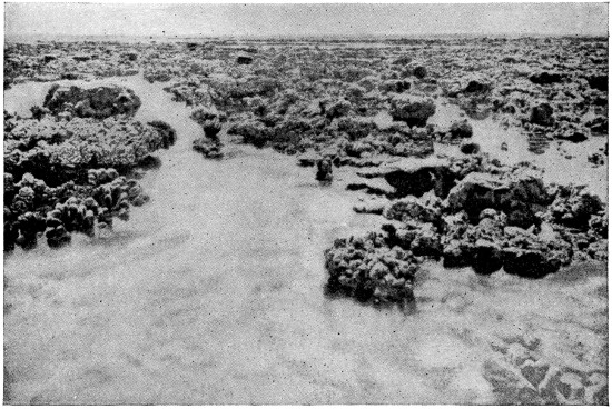
THE BARRIER CORAL REEF OF AUSTRALIA
This vast reef of coral islands was built by a colony of coral insects, or polyps, as innumerable as the stars of the Milky Way. It rose from the floor of the ocean, builded out of myriads upon myriads of the dead skeletons of these marvellous insects.
COMBINATION OF VOLCANIC AND CORAL ISLANDS
A large number of volcanic islands in the Pacific are encircled by coral reefs, which, when near the shore, are called fringing reefs. When at a considerable distance, leaving a lagoon of quiet water between them and the volcanic island, they are termed barrier reefs.
CORAL REEFS AND THEIR BUILDERS
Coral reefs are masses of limestone originally secreted, in the form of coral, by minute polyps which live in countless numbers in the tropical seas. The coral produced by a single community of polyps grows chiefly upward; but multitudes of distinct communities often live so near together that the small lateral growth of each brings them into contact.
Their separate, fragile structures, gradually broken up and compacted by various means, are in time transformed into a solid mass, forming walls of coral rock frequently of enormous extent. The great barrier reef near the northeastern shores of Australia, the longest known, is not less than one thousand two hundred and fifty miles in length.
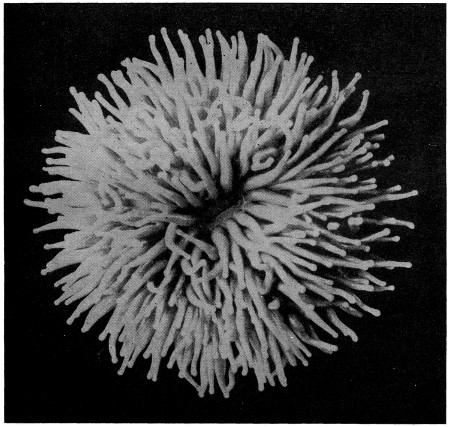
A LIVING SINGLE CORAL FROM THE PACIFIC OCEAN
The coral polyp is one of the master-builders of the world. It may be likened to a sea-anemone, but is inferior in muscular organism, and immensely superior in defensive organization.
Reef-building polyps do not live below the depth of one hundred or one hundred and twenty feet, and hence require a foundation near the surface. This is supplied by submarine mountains and plateaus, or the slopes of those volcanic cones which form the high islands.
Growing vertically, the reefs repeat at the surface the outlines of their bases, which fact gives rise to the circular figure both of atolls and reefs in mid-ocean, and to the elongated, wall-like form of reefs adjacent to the continents, like those of Florida and of Australia.
DISTRIBUTION OF CORALS
Reef-building polyps are confined to the tropical seas, where the winter temperature is not below sixty-eight degrees. Coral formations are most extensive in the Pacific Ocean, especially south of the Equator, and in the two great archipelagoes of the East and West Indies; but a large number of coral islands also occur in the Indian Ocean. The Coral Sea, east of northern Australia, is particularly remarkable for the great extent of its coral reefs.
THE ATOLL FORM OF ISLAND
The usual form of coral islands is that of a broken ring, numerous channels affording entrance into the lagoon. Such a group of islands is called an atoll, a Malay term, which has been adopted to designate these singular structures. The central lagoon enclosed by an atoll, is invariably shallow, seldom exceeding a few scores, or at most hundreds, of feet in depth; while the outer sea reaches a depth of thousands of feet at a short distance from the shore, showing that the atoll rests upon a submarine mountain.
Atolls are often clustered together in large numbers, forming extensive archipelagoes. Paumotu, or Low Archipelago, numbers eighty coral islands, nearly all of which are atolls; the Caroline, Gilbert and Marshall islands together contain eighty-four atolls, while the Laccadive and Maldive islands form two long double series of atolls extending eight hundred miles from north to south.
MAP SHOWING COMPARATIVE SIZE OF ISLANDS
(See next page for the Area, Population and Countries to which these islands belong).
ISLANDS OF WESTERN HEMISPHERE
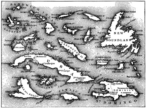
Large illustration (404 kB)
MOST NOTED ISLANDS OF THE WORLD—WESTERN HEMISPHERE
Name and Sovereignty Area Square Miles Popula- tion
Anticosti (to Britain) 2,600 500
Bahamas (to Britain) 4,404 58,000
Bermudas (to Britain) 20 20,000
Cape Breton (to Britain) 3,120 100,000
Cuba (Independent) 44,164 2,155,000
Dominica (to Britain) 291 35,000
Falkland (to Britain) 5,500 3,250
Feeji, or Feejee (to Britain) 7,435 155,000
Galapagos (to Ecuador) 2,400 400
Greenland (to Denmark) 46,740 15,000
Guadeloupe (to France) 688 182,000
Hawaiian See Sandwich.
Isla de Pinos (Isle of Pines) (to Spain) 1,200 32,000
Jamaica (to Britain) 4,200 865,000
Long Island (to U. S.) 1,682 2,700,000
Martinique (to France) 378 180,000
New Foundland (to Britain) 42,734 218,000
Porto Rico (to U. S.) 3,604 1,120,000
Prince Edward (to Britain) 2,184 94,000
Santo Domingo (Independent) 28,250 2,700,000
Sandwich or Hawaiian (to U. S.) 6,449 192,000
Staten Island (to U. S.) 65 86,000
Tahiti (to France) 1,500 30,000
Tierra del Fuego (to Argentina) 18,500 1,700
Trinidad (to Britain) 1,750 350,000
Vancouver (to Britain) 15,937 55,000
MAP SHOWING COMPARATIVE SIZE OF ISLANDS
ISLANDS OF EASTERN HEMISPHERE
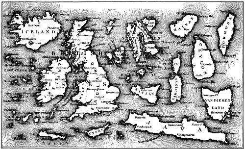
Large illustration (323 kB)
MOST NOTED ISLANDS OF THE WORLD—EASTERN HEMISPHERE
Name and Sovereignty Area Square Miles Popula- tion
Balearic Islands (to Spain) 1,935 326,000
Borneo (to Britain and Holland) 284,000 2,000,000
Canary Islands (to Spain) 2,807 420,000
Candia, or Crete (to Turkey) 3,365 243,000
Cape Verde Islands (to Portugal) 1,480 148,000
Celebes (to Holland) 71,470 2,000,000
Ceylon (to Britain) 25,332 3,595,000
Corsica (to France) 3,378 290,000
Cyprus (to Britain) 3,584 140,000
Elba (to Italy) 85 27,000
England (Independent) 88,729 40,835,000
Formosa (to Japan) 13,458 3,392,000
Gothland (to Sweden) 1,217 56,000
Hainan (to China) 16,000 2,000,000
Iceland (to Denmark) 39,756 86,000
Ireland (to Britain) 32,360 4,382,000
Japan - Honshiu 87,485 37,415,000
Khiushiu 16,840 7,727,000
Skikoku 7,031 3,290,000
Hokkaido (Yezo) 36,299 1,140,000
Java (to Holland) 50,554 30,100,000
Madagascar (to France) 227,950 2,745,000
Madeira Islands (to Portugal) 314 150,600
Malta (to Britain) 117 229,000
New Guinea See Papua.
New Zealand (to Britain) - N. Island 44,468 564,000
S. Island 58,325 445,000
Papua, or New Guinea (to Britain, Germany and Holland) 313,183 710,000
Philippines (to U. S.) - Luzon 40,969 3,800,000
Mindanao 36,292 500,000
Panay 4,611 744,000
Cebu 1,762 593,000
Leyte 2,722 358,000
St. Helena (to Britain) 47 3,520
Sakhalin (Japan and Russia) 29,000 30,000
Sardinia (to Italy) 9,306 854,000
Sicily (to Italy) 9,935 3,685,000
Spitzbergen (to Norway) 27,000 ...
Sumatra (to Holland) 165,000 3,200,000
Van Diemen, or Tasmania (to Britain) 26,215 197,000
Zanzibar (to Britain) 640 115,000
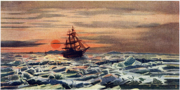
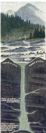
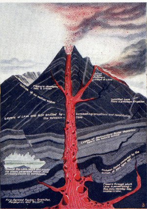
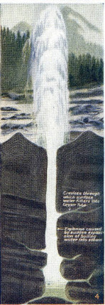
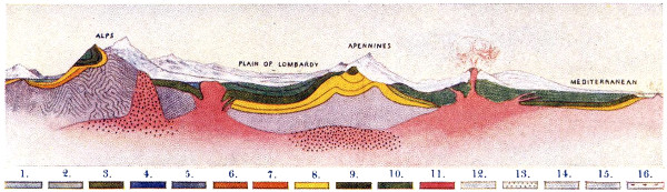
MARVELS OF THE EARTH’S ROTATION, FORCES AND STRUCTURE
1. Midnight Sun Within the Arctic Circle. 2. The Geyser At Rest. 3. Picture Diagram of a Section through a Volcano like Vesuvius. 4. The Geyser in Action. 5. Section of the Earth’s Crust across France and Italy.
1. Precambrian or Archaean. 2. Cambrian and Ordovician. 3. Silurian. 4. Carboniferous Limestone. 5. Coal Measures. 6. Permian. 7. Trias. 8. Jurassic. 9. Chalk. 10. Tertiary. 11. Volcanic Rocks. 12. Glacial Deposits. 13. Granite. 14. Gneiss. 15. Schist. 16. Alluvium.
Large illustrations: Fig. 2 (left) (272 kB) Fig. 3 (center) (416 kB) Fig. 4 (right) (190 kB) Fig. 5 (bottom) (133 kB)
VOLCANOES, GEYSERS AND EARTHQUAKES
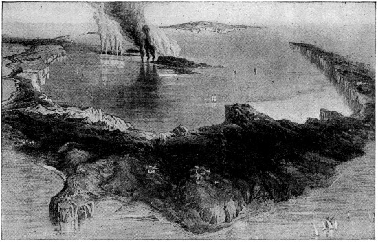
THE REMARKABLE SUBMARINE VOLCANO OF SANTORIN (Săn-to-rē´n)
In this little Bay of Santorin, enclosed by an island of the same name in the Grecian Archipelago, occurred probably the most remarkable volcanic exhibition known. During an eruption in 1866 flames issued from the sea rising sometimes to a height of twenty-five feet, and a dense column of white smoke mounted to an immense height. Within a few days a new island appeared which gradually became united to the present Santorin.
CAUSE, STRUCTURE AND LOCATION OF VOLCANOES
The primary cause of volcanoes, as of geysers, earthquakes and other similar phenomena of nature, is the intensely heated condition of the earth’s interior. It is the same force that has produced the irregular features of the earth’s surface—its mighty mountain chains, the sunken basins of the oceans, and its hills, valleys and gorges. Quite logically, volcanoes are most numerous and most intense along the deep mountain fissures which establish a ready communication between the interior and the surface of the earth. Consequently the significant facts about them are: (1) Nearly all volcanoes are either along the highest border of the continents, or in the great central zone of fracture; (2) most of the volcanic groups exhibit a linear arrangement; (3) the agent at work in these mighty engines is mainly vapor of water, or steam power.
WHAT VOLCANOES ARE AND HOW THEY ACT
The form of typical volcanic mountain is that of a cone, with a circular basin or depression, called a crater, at its summit. In the center of the crater is the mouth of a perpendicular shaft or chimney, which emits clouds of hot vapor and gases; and in periods of greater activity, ejects ashes, fragments of heated rock, and streams of fiery lava.
Volcanic ashes, when examined under a microscope, are found to be simply pulverized lava, frequently in minute crystals, and bear no resemblance to ashes in the ordinary sense of the term.
The lava stream, when flowing white hot from the crater, is not unlike a jet of melted iron escaping from a furnace, and moves at first with considerable rapidity. It soon cools on the surface, and becomes covered with a hard, black, porous crust, while the interior remains melted and continues to flow. If the stream is thick, the lava may be found still warm after ten or even twenty years.
The amount of matter ejected by volcanoes is very great. The whole island of Hawaii, the largest of the Hawaiian Islands, seems to be only an accumulation of lava thrown out by its four craters. All high oceanic islands are of the same character. Iceland, with an area of forty thousand square miles, is a vast table-land from three thousand to five thousand feet in elevation, composed of volcanic rock similar to the lavas still ejected by its numerous volcanoes.
VESUVIUS THE MOST REMARKABLE VOLCANO
Nearly all active volcanoes have intervals of comparative repose, interrupted by periods of increased activity, which terminate in a violent ejection of matter from the interior, during which the volcano is said to be in a state of eruption.
The phenomena which characterize these differing phases of volcanic activity may be best made clear by describing them as actually observed in Vesuvius, one of the most carefully studied and most active volcanoes of modern times.
Vesuvius is a solitary mountain rising to the height of nearly 4,000 feet, from the midst of a highly cultivated plain which borders upon the shores of the Bay of Naples. Though the mountain has a regular conical form, two summits, very nearly equal in height, are visible from Naples—Monte Somma on the north, and Vesuvius proper on the south.
The Eruption begins generally with a tremendous explosion which seems to shake the mountain to its very foundations, and hurls into the air dense clouds of vapor and ashes. Other explosions succeed rapidly, and with increasing violence, each sending up a white, globular cloud of steam, or aqueous vapor. This long array of clouds, accompanied by dark ashes, volcanic sand, and fragments of red-hot lava of all sizes, soon forms a stupendous column.
Finally the boiling lava overflows the rim of the crater, and descends in fiery torrents down the slopes; or, bursting the mountain by its weight, finds a vent through some fissure far below the summit. After the expulsion of the lava the eruption is generally near its end, though it does not necessarily terminate at once. Alternate phases of outbursting steam, ashes, and lava may continue with more or less violence for weeks or even months.
The sudden condensation of the enormous accumulation of hot vapor thrown into the air by the eruption, gives rise to striking atmospheric phenomena. Vivid flashes of lightning start from all parts of the column, and play about the clouds above; and often a local thunderstorm, formed in the midst of a clear sky, pours a heavy rain of warm water and ashes upon the slopes of the mountain. The hot, destructive mud torrents, created by these rains, have often been mistaken for lava streams.
The majesty of the spectacle is still greater at night. Though flames of burning gases are of rare occurrence, the clouds and columns of vapor are strongly illuminated by the reflection of the white-hot lava within the crater; and fragments of this lava constantly thrown into the air give the column all the brilliancy of a gigantic piece of fire-work. The sky itself, far and wide, partakes of the same vivid coloring, and the whole scene resembles a vast conflagration.
SIZE AND DISTRIBUTION OF VOLCANOES
In size they vary from mere mounds a few yards in diameter, such as the salses or mud-volcanoes near the Caspian, to Etna, 9,652 feet high, with a base thirty miles in diameter; Cotopaxi, in the Andes, 18,880 feet high; or Mauna Loa, in the Sandwich Isles, 13,600 feet high, with a base seventy miles in diameter and two craters, one of which, Kilauea, is the largest active crater in our earth, being seven miles in circuit.
Two great terrestrial zones include nearly all the known volcanoes of the globe, arranged in long bands or series, or in isolated groups.
First Zone. This includes the vast array of mountain chains, peninsulas, and bands of islands which encircle the Pacific Ocean with a belt of burning mountains. Within it occur, in the New World: (1) the Andes mountains, with three of the most remarkable series of volcanoes—those of Chili, Bolivia, and Ecuador—separated by hundreds of miles; (2) the volcanic group of Central America; (3) the series of Mexico; (4) the series of the Sierra Nevada and Cascade mountains; (5) the group of Alaska; and (6) the long series of the Aleutian Islands.
In the Old World are: (1) the series of Kamchatka and the Kurile Islands; (2) the group of Japan; (3) the series south of Japan, including Formosa, the Philippine and the Molucca Islands; and (4) the Australian series, including New Guinea, New Britain, New Hebrides, and New Zealand. In this vast zone there are not less than four hundred volcanoes, one hundred and seventy of which are still active.
Second Zone. This contains the belt of broken lands and inland seas, which extending round the globe, separates the northern from the southern continents, and intersects the first zone, in the equatorial regions, nearly at right angles.
In it are: (1) the volcanic regions of Central America and Mexico, and the series of the Lesser Antilles; (2) the groups of the Azores and Canary islands (3) the Mediterranean islands and peninsulas, including all the active volcanoes of Europe; (4) Asia Minor with numerous extinct volcanoes; (5) the shores of the Red Sea and Persian Gulf, and the two Indias, rich in traces of volcanic action; (6) the East Indian Archipelago with hundreds of burning mountains; and (7) the Friendly Islands and other volcanic groups of the central Pacific.
In this zone there are no less than one hundred and sixty volcanoes, so that the two volcanic zones together contain five hundred and sixty, or five-sixths of all known.
Isolated Volcanoes. The volcanoes not included in these two great zones are isolated, in the midst of the oceans, or in the broken polar lands. The most noted are the Hawaiian Island group, in the Pacific; Bourbon and Mauritius, in the Indian Ocean; Cape Verde Islands, Ascension, St. Helena, and Tristan da Cunha, in the Atlantic; Iceland and Jan Mayen, in the Arctic Ocean; and Erebus and Terror, in Antarctic.
MOST NOTED VOLCANOES
Name Location Height (feet)
Altar Ecuador 17,710
Antisana Ecuador 19,335
Asosan Japan 5,630
Cayambi Ecuador 19,255
Chimborazo Ecuador 21,424
Copiapo Chile 19,700
Cotocachi Ecuador 16,300
Cotopaxi Ecuador 18,880
Demavend Persia 18,500
Etna Sicily 9,652
Fujiyama Japan 12,390
Hecla Iceland 5,110
Hood, Mt. Oregon 11,225
Iztaccihuati Mexico 16,076
Kirishima-yama Japan 5,530
Llullaillac Chile 21,000
Maipo Chile 17,670
Mauna Kea Hawaii 13,953
Mauna Loa Hawaii 13,600
Misti Peru 20,015
Nevado de Colima Mexico 14,210
Orizaba Mexico 18,310
Pelée Martinique, W. I. 4,300
Pichincha Ecuador 15,918
Pico, Peak of Azores 7,013
Popocatepetl Mexico 17,748
Ruiz Colombia 17,388
Sahama Peru 23,000
Sangai Ecuador 17,459
San Jose Chile 20,020
St. Elias, Mt. Alaska 18,024
St. Helena, Mt. United States 10,000
Stromboli Lipari Islands 3,090
Tahiti, Peak of Friendly Islands 7,400
Teneriffe Canary Islands 12,000
Tolima Columbia 18,069
Toluco Mexico 14,950
Tunguragua Ecuador 16,690
Vesuvius Italy 4,260
EARTHQUAKES
Earthquakes are movements of the earth’s crust, varying in intensity from a slight tremor or shaking of the ground to the most violent convulsions causing enormous destruction over wide areas.
KINDS OF MOTION OBSERVED IN EARTHQUAKES
The wave-like or undulatory motion is most common and least destructive. It appears to be the normal one, and it is possible that the others may be simply the result of various systems of waves intersecting one another. The waves either advance in one direction, like waves of the sea, or spread from a central point, like ripples produced by dropping a pebble into still water.
The earthquakes of the Andes are chiefly linear, being propagated along the mountains, with the undulations perpendicular to the direction of the ranges. The destructive earthquake at Lisbon, was a central one, the concentric waves gradually diminishing in intensity with increasing distance from the place of origin.
The vertical motion acts from beneath like the explosion of a mine, and when violent nothing can resist its force. The earthquake at Calcutta, in September, 1828, owed its great destructiveness to the fact that the main shock was vertical; and one in Murcia, Spain, in 1829, destroyed or injured more than three thousand five hundred houses.
The rotary or whirling motion is the most dangerous, but happily the rarest of all. In the great earthquake of Jamaica, in 1692, the surface of the ground was so disturbed that fields changed places, or were found twisted into each other.
EARTHQUAKE SHOCKS AND SOUNDS
Probably no part of the earth’s surface is entirely free from vibration, but, fortunately, destructive earthquakes are confined to comparatively limited regions. In most cases each shock lasts only a few seconds, but the tremblings that follow may be continued for days, weeks, or even months. Noises of sundry kinds usually precede, accompany, or succeed an earthquake. Some earthquakes, however, are not attended by any subterranean sounds. This has been the case with some of the most destructive South American disturbances. Thus at the time of the terrible shock which destroyed Riobamba in Ecuador in 1797, a complete silence reigned. On the other hand, subterranean sounds may be heard without any earth-tremor being perceived.
The sound which accompanies many earthquakes is due to the transmission to the air of vibrations in the soil. To produce sound-waves in the air, the ground must vibrate like a drumhead. Hence no sound will be heard when the oscillations are horizontal.
The velocity of propagation of an earthquake is very variable. Thus in the case of the earthquake of Lisbon in 1755, it seems to have considerably exceeded one thousand feet per second, while in the Lisbon earthquake of 1761 the rate was three times greater. At Tokio, in 1881, the velocity, as estimated by Professor Milne, varied between four thousand feet and nine thousand feet per second.
Depth of Earthquakes. Various attempts have been made to estimate the depth at which earthquakes originate. Mallet was of opinion that the centrum of the Neapolitan earthquake of 1857 was probably five and one-half miles from the surface. The same eminent physicist thought that an earthquake centrum probably never exceeded a depth of thirty geographical miles. According to Professor Milne, the angles of emergence of the earth-waves obtained during the Yokohama earthquake of 1880 showed that the depth of origin of that earthquake might be between one and one-half and five miles; and he gives a table, compiled from the writings of various observers, which exhibits the mean depths at which certain earthquakes have originated. These estimated depths range from 17,260 feet to 127,309 feet.
The area disturbed by an earthquake is generally proportionate to the intensity of the shock. The great earthquake of Lisbon disturbed an area four times as great as the whole of Europe. In the form of tremors and pulsations, Mr. Milne remarks, it may have shaken the whole globe.
In a violent submarine earthquake the ordinary earth-wave and sound-wave are accompanied by sea-waves. These waves may be twenty, sixty or even eighty feet higher than the highest tide, and are usually more dreaded than the earthquake shock itself in such regions as the maritime districts of South America. The greatest sea-wave on record is that which in 1737, is said to have broken near Cape Lopatka, at the south end of Kamchatka, two hundred and ten feet in height.
NOTABLY DESTRUCTIVE EARTHQUAKES
79. One accompanied by the eruption of Vesuvius; the cities of Pompeii and Herculaneum buried.
742. Awful one in Syria, Palestine, and Asia; more than 500 towns were destroyed and the loss of life surpassed all calculations.
936. Constantinople overturned; all Greece shaken.
1137. Catania, in Sicily, overturned, and 15,000 persons buried in the ruins.
1186. At Calabria; one of its cities and all its inhabitants overwhelmed in the Adriatic Sea.
1456. At Naples, 40,000 persons perished.
1537. At Lisbon; 1,500 houses and 30,000 persons buried in the ruins; several neighboring towns ingulfed with their inhabitants.
1596. In Japan; several cities made ruins, and thousands perished.
1662. One in China, when 300,000 persons were buried in Pekin alone.
1693. One in Sicily, which overturned fifty-four cities and towns, and 300 villages. Of Catania and its 18,000 inhabitants not a trace remained; more than 100,000 lives were lost.
1726. Palermo nearly destroyed; 6,000 lives lost.
1731. Again in China; and 100,000 people swallowed up at Pekin.
1746. Lima and Callao demolished; 18,000 persons buried in the ruins.
1754. At Grand Cairo; half of the houses and 40,000 persons swallowed up.
1755. Quito destroyed.
1755. Great earthquake at Lisbon. In about eight minutes most of the houses and upward of 50,000 inhabitants were swallowed up, and whole streets buried. The cities of Coimbra, Oporto, and Braga suffered dreadfully, and St. Ubes was wholly overturned. In Spain, a large part of Malaga became ruins. One-half of Fez, in Morocco, was destroyed, and more than 12,000 Arabs perished there. About half of the Island of Madeira became waste; and 2,000 houses in the Island of Mytilene, in the Archipelago, were overthrown. This awful earthquake extended 5,000 miles; even to Scotland.
1759. In Syria, extended over 10,000 square miles; Baalbec destroyed.
1783. Messina and other towns in Italy and Sicily overthrown; 40,000 persons perished.
1797. The whole country between Santa Fe and Panama destroyed, including Cusco and Quito, 40,000 people buried.
1840. Awful and destructive earthquake at Mount Ararat, in one of the districts of Armenia; 3,137 houses were overthrown, and several hundred persons perished.
1842. At Cape Haytien, St. Domingo, which destroyed nearly two-thirds of the town; between 4,000 and 5,000 lives were lost.
1851. In South Italy; Melfi almost laid in ruins; 14,000 lives lost.
1852. At Philippine Isles; Manila nearly destroyed.
1853. Thebes, in Greece, nearly destroyed.
1854. St. Salvador, South America, destroyed.
1854. Amasca, in Japan, and Simoda, in Nippon, destroyed; Jeddo much injured.
1855. Broussa, in Turkey, nearly destroyed.
1857. In Calabria, Montemurro and many other towns destroyed, and about 22,000 lives lost in a few seconds.
1858. Corinth nearly destroyed.
1859. At Quito; about 5,000 persons killed, and an immense amount of property destroyed.
1868. Cities of Arequipa, Iquique, Tacna, and Chincha, and many small towns in Peru and Ecuador destroyed; about 25,000 perished.
1883. Krakatoa island, between Sumatra and Java, East Indies, was the scene of a series of volcanic discharges in May to August, 1883, constituting the most tremendous eruption known to history. A cubic mile of rock material was hurled into the air, and the explosions were heard 150 miles away. Violent atmospheric disturbances and gigantic sea-waves, the latter causing great loss of life, estimated at more than 30,000. As a result of the explosion, the north part of the island, including its highest peak, altogether disappeared.
1886. Shocks throughout eastern United States; at Charleston, S. C, 41 lives and $5,000,000 worth of property lost.
1893. Islands of Zante and Stromboli, the former west of Greece, the latter one of the Lipari group, west of Calabria, Italy, severely shaken. Great loss of lives and property at Zante.
1906. Severe shocks in California wrecked San Francisco and adjacent towns, and caused the greatest fire in history, lasting two days. Great loss of life, and $300,000,000 of property destroyed; over 300,000 homeless. Stanford University buildings were damaged to the extent of $2,800,000, including the fine Memorial Church.
1906. At Valparaiso, Chile, causing great destruction of life and property.
1907. Large part of Kingston, Jamaica, destroyed.
1909. In Sicily and southern Italy, Messina and many towns and villages desolated. Appalling loss of life; thousands buried alive; the survivors homeless; one of the greatest earthquakes of modern times if not of all time.
GEYSERS
Geysers are eruptive hot springs found chiefly in volcanic districts, but particularly in the Yellowstone Park, Iceland, New Zealand, Tibet and the Azores. At intervals these fountains of hot water and steam sometimes rise to a height of two hundred feet. The eruptions occur at intervals varying from every hour to once a day.
All the geyser waters hold in solution a considerable quantity of silica. The highly heated water decomposes the felspar and other volcanic rocks, and becoming slightly alkaline with the soda or potash these contain, it is enabled to form a silicious solution. The silica taken up is deposited again round the mouth of the orifice. Minute plants termed algæ are known to live in the hot water, and to aid in throwing down the silica from solution to form the sinter deposits.
The cause of the periodical eruptions is probably to be found in the gradual increase of heat with the depth of the tube. In the middle and lower parts the temperature is far above the boiling-point (212° F.) at the ordinary pressure. But at last the lower portion rises to a position where the temperature is above the boiling-point at the pressure it there sustains, and then, flashing into steam, it hurls the column above into the air. After playing for a few minutes the water falls back into the basin, and remains quiet for a time.