Chapter II · The Nature of the Target
Reading edition
The Philippine Islands, the largest island group in the Malay Archipelago, were discovered by Ferdinand Magellan in 1521. They became a Spanish possession in 1565 and remained so until 10 December 1898 when they were ceded to the United States by the Treaty of Paris as a result of the Spanish-American war. In the spring of 1942 Japan secured military domination over the Islands.
The Philippine Archipelago lay in the geographical heart of the Far Eastern theater of war. As a pivotal point of control the Islands were centrally placed in relation to Japan, China, Burma, French Indochina, Thailand, British Malaya, and the Netherlands Indies. Being the most northerly part of the Malay Archipelago, the Philippines were also close to the vital areas of Japan and the Chinese-held areas of the Asiatic mainland. Located southeast of the continent, they occupy much the same position with respect to the mainland of Asia that the West Indies do with respect to North America.
Geography of Leyte
Leyte roughly resembles a molar tooth with its crown toward Samar and its roots pointing to Mindanao. The eighth largest island in the Philippines, with an area of 2,785 square miles, it runs generally from north to south, with an approximate length of 115 miles and a width of 15 to 45 miles. It is situated on one of the principal submerged shelves of the Philippine Archipelago, and the waters over the shelf have an average depth of 22 fathoms. (Map 2—inside back cover)
The Terrain
The island is mainly volcanic in origin. A range of mountains, the topographical backbone of the island, extends southeast from Biliran Strait in the north to Cabalian Bay in the south and separates the Leyte and Ormoc Valleys. All of southern Leyte is mountainous and, militarily speaking, of little importance. The northwest coast is also rugged, and except for the port of Palompon has little tactical significance. The heavily forested central mountain range is composed of numerous knifelike ridges and spurs and deep ravines and serves as an effective natural barrier between the island’s eastern and western coastal areas. It is a major obstacle to the rapid movement of troops and can be utilized very effectively in defending the island.
Leyte Valley, a broad and fertile plain, stretches across the northeastern part of the island from Leyte Gulf to Carigara Bay. More than twenty-five miles wide along the shore of the gulf, it is gradually narrowed by the mountain ranges to the north and south to less than ten miles as it reaches Carigara Bay. Most of the island’s population live in this valley, and here too are most of the principal cities and airfields.
The shore line of Leyte Valley along Leyte Gulf and San Pedro Bay affords the best landing beaches on the island. This coast is dangerous for beach landings during northeast monsoon periods, when heavy surf, high winds, and torrential rains imperil men, equipment, and shipping. July, August, and September are the best months for landing. In general there are good firm sand beaches, onto which landing craft can go directly. A road parallels the shore line, but there are few exit roads from the beach to this road and beyond. In many places close to the shore there are swamps and rice paddies which prevent rapid egress from the beach. There are other good landing beaches on the east coast of Ormoc Bay, but they are crossed by innumerable creeks and streams.
Leyte Gulf is large and open, offering an excellent anchorage for a considerable number of vessels, including those of largest size. Carigara Bay, to the north of the island, is twenty miles wide, but shallow waters, swamps, and the hilly terrain of its eastern and western sides restrict its value for military operations. A narrow neck of the central mountain range separates the bay from the northern end of Ormoc Valley. San Juanico Strait, which separates Leyte from Samar in the north, connects Carigara Bay and San Pedro Bay, the latter being a northern extension of Leyte Gulf. The strait is thirteen and a half miles long with an average width of a quarter to a half mile. Small landing craft can navigate the channel, but there are strong tidal currents which cause violent rips and swirls at many points.
The largest city on the island, the provincial capital, is Tacloban, which lies at the head of San Pedro Bay. As the only sizable port in the area, it handles most of the outbound shipping, mainly from Leyte and Samar. Its prewar population was about 31,000. Other important towns are Carigara and Barugo on the north coast; Baybay and Ormoc, the leading ports on the west coast; and Palo, Tanauan, and Abuyog along the east coast. All the more significant towns are situated on the main road system of the island, and the larger coastal barrios (villages) have roads of a sort.
The road system is divided into a northern and a southern coastal road net. The former, which is the better, was designed for the transportation of agricultural produce from the northern interior areas to Tacloban. The latter is composed of narrow, roundabout roads that are constantly in need of repair. The two systems are joined by a road, scarcely better than a trail, which runs west of Abuyog and corkscrews its way through heavily forested mountains to Baybay. Another road, long, narrow, and broken in parts, goes north from Baybay to Ormoc and thence through the Ormoc Valley to Carigara.
The Tacloban airstrip, the principal airfield on the island, was located on the Cataisan Peninsula, which lies just southeast of Tacloban. The Japanese had constructed another airfield, known as the Dulag airstrip, two miles west of Dulag; three others—the Buri, Bayug, and San Pablo airstrips—near Burauen, five miles west of Dulag; and still another at Valencia in the Ormoc Valley, eight miles north of Ormoc.
Control of the island of Leyte is dependent upon control of the Leyte and Ormoc Valleys and their adjacent hills and mountains. Thus, before a successful movement into Leyte Valley could be assured, control of the high ground in the vicinity of Palo would be essential. Continued dominance over the valley is dependent upon control of the high ground at its northwestern end in the vicinity of Pinamopoan on Carigara Bay, possession of which would preclude infiltration from Ormoc Valley. The control of Ormoc Valley and use of the excellent anchorage and harbor facilities of Ormoc Bay is dependent upon control of the lowland in the vicinity of Ormoc city and the commanding hills to the east.
The People
In 1939 the total population of Leyte was 915,853, of whom more than 912,000 were native Visayans of Malaysian stock. The largest other group consisted of 3,076 Chinese, half of whom were engaged in retail trade. There was a sprinkling of other national groups—40 Spaniards, 20 Germans, 81 from other European countries, 56 Americans, and 73 Japanese.
Because of their insular position and somewhat primitive culture, the inhabitants are primarily an agricultural and fishing people. The principal crops are rice, sugar cane, corn, and copra. Judged by Occidental standards, the mode of farming is backward and shows little tendency to progress. The Filipinos who have been exposed to industrial life, however, have been able to adapt themselves to employment in the limited trade crafts and manufacturing on the island.
According to his own standards, the Filipino lives well enough. His chief foods are rice or corn, fish, camotes (sweet potatoes), and occasionally chicken or other meat. The men’s clothing is simple; the average man has several changes of cheap cotton shirts and pants made of imported cotton cloth or, in the more remote districts, from homespun material.
Most of the dwelling houses are made of bamboo and sheathed with palm leaves on roof and sides. The material is gathered locally and tied with rattan. The houses rarely consist of more than two rooms, and many are raised on pilings, with space for the family pig and chickens underneath. In one of the rooms, or outdoors, is an open fireplace with a mud and stone hearth for cooking. There is little furniture, and in three out of four families the personal possessions would not be worth more than ten dollars.
Less than 5 percent of the people have a rising standard of living. This higher standard is exemplified by a better type of habitation, which ranges from a three-room house to a dwelling similar to that of the American middle class. The diet of more prosperous Filipinos is basically the same as that of the poorer class, but it offers a greater variety. Clothing follows the Occidental fashion. The wealthiest people and those with foreign education or contacts, who make up less than 1 percent of the population, dress and live in the same manner as Occidentals.
The Japanese, during their occupation, governed through the old administrative organization of the province. They and their puppet officials also set up larger governing bodies that exercised superior jurisdiction. On 6 February 1944 the puppet president of the Philippine Republic, José Laurel, appointed a commissioner who held supervisory power over the local governments in the Visayan Provinces.
The governor of the province of Leyte, who previously had been an elected official, was appointed by the president. He was the chief operative and administrative head of the province and on all provincial administrative matters his decision was final. The treasurer of the province, who reported directly to the governor, was its chief financial officer and tax assessor. He collected all taxes and license fees, national and local, and prepared financial statements for the governor but he had no say in administrative matters. The law officer of the province was legal adviser to the governor and to the municipal authorities. He could advise only on administrative matters.
The Japanese Military Administration maintained liaison between the Japanese Army and the civil government. The military police collected military intelligence and information and disseminated propaganda. The Japanese allowed only one political party on the Islands—the Kalibapi—to which all government officials were required to belong. This party was one of the principal propaganda agencies, being the prime mover of the pacification programs in the province, and exercised general supervision over the local neighborhood associations. The latter helped in maintaining law and order, assisted the constabulary, and aided in the distribution of scarce commodities.
It should be emphasized that during most of the occupation there were few Japanese on Leyte. Southern Leyte in general maintained the same Filipino institutions and officials as in the prewar years. The heel of the Japanese conqueror pressed but lightly on most of the people of Leyte. Beginning in early 1944, however, the Japanese Army forces on the island were reinforced. From that time forward the Filipinos had their crops appropriated and in other ways were subjected to the will of the Japanese. Misery, hunger, and poverty became commonplace and a resistance movement grew.
The Resistance Movement on Leyte
The Organizing of Guerrilla Bands
A period of uncertainty and confusion followed the surrender of the American and Filipino forces in the Philippines in the spring of 1942. Civilians and members of the armed forces who did not surrender to the Japanese Army fled into the hills. Some went because they wanted to continue the fight, others because they felt that the chaotic conditions on the Islands would afford unequaled opportunities for looting and pillaging.
The following oath of allegiance taken by the members of one of the bands is probably typical:
I do solemnly swear that I shall obey orders from my superior officer; that I shall fight the enemy of the Government of the Commonwealth of the Philippines and the United States of America whosoever and wherever he maybe [sic] in the territory of the Philippines; that I shall never allow myself nor any arm or ammunition to be caught by the enemy; that I shall never turn traitor to my country nor the United States of America; and muchless [sic] reveal to the enemy any secret of the Army to which I honorably belong; that I shall never abandon a wounded brother in arms; that I join the United Forces in the Philippines without personal or party interest, but with the determination to sacrifice myself and all that is mine for FREEDOM and DEMOCRACY; that I shall protect the lives and property of all loyal Filipinos everywhere.
I make this LOYALTY OATH without mental reservation or purpose of evasion.
For some time the various guerrilla bands on Leyte operated separately, and there was little or no co-operation between them. They were united, however, in their hatred of the Japanese. Jealousy and strife between groups were rampant, but circumstances gradually compelled the smaller bands to submit to absorption, either by force or persuasion, into the larger and more powerful groups. The fact that there were few Japanese on the island enabled the guerrillas and loyal provincial officials to organize the governments of most of the barrios.
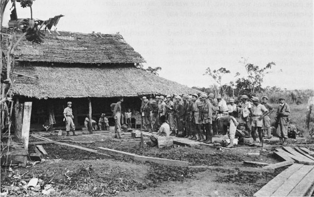
GUERRILLAS PREPARE FOR INSPECTION AT CONSUEGRA
All of the guerrillas declared that their primary purpose was to aid the civilians, maintain peace and order, and keep the Japanese from abusing the people. They also assumed control over various phases of public activities—the allotment of food supplies, the issue of emergency currency, and the punishment of criminals. The guerrillas in northern Leyte depended upon voluntary contributions to support them, while those in southern Leyte levied a loyalty tax. Hard money having been driven out of circulation, the guerrilla units tried to issue paper, which was acceptable only in those regions where the particular unit was active. There was no widespread circulation or acceptance of any of the guerrilla money.
Japanese Punitive Expeditions
After their attempts at pacification, the Japanese launched more frequent and intensive patrols against the guerrillas. The garrison troops that had been stationed on Leyte were reinforced. Southern Leyte, which had known few Japanese, was “reinvolved” on 8 December 1943. The guerrillas withdrew and hid in the interior. It was thought that after a month the troops would leave and be replaced by constabulary officers. But after two weeks the Japanese turned their attention to the civilians. Some they arrested and imprisoned for days without food and water, others they tortured and executed. Houses were broken into, property was looted, and food was stolen. Spies were brought in from neighboring islands to locate the guerrilla hideouts.
Since the people begged for action, Colonel Kangleon held a meeting of his unit commanders on 24 January 1944. With his officers in unanimous accord, he issued an order to fight, commencing on 1 February 1944. All officers and enlisted men of his command signed a loyalty oath that they would not allow either themselves or their weapons to be captured.
From 1 February until 12 June, according to Colonel Kangleon, the guerrillas in southern Leyte had only 10 casualties. In a report dated 18 May 1944, the Japanese casualties were listed as 434 killed, of whom 4 were officers, and 205 wounded.
Colonel Kangleon stated that as a result of guerrilla activities the Japanese sent out fewer patrols, staying mainly in the towns. The civilians, he claimed, were therefore able to plant and harvest their crops. Despite these brave words the guerrillas were definitely on the defensive, since Japanese intelligence had accurate information on their movements and strength. Nevertheless, the Japanese also knew that the guerrillas had established communication with General MacArthur in Australia and that they were sending important information to General Headquarters. This service the Japanese were unable to cut off.
Liaison Between Leyte and Australia
Armed with these instructions, Major Villamor returned to the Philippine Islands. Slowly but carefully, from December 1942 to November 1943, he established an intelligence network that covered Luzon and the Visayan Islands. His story is told in part as follows:
As a result of information received from the intelligence network, on Leyte and in other areas, together with information from other sources, General MacArthur’s intelligence officers were able to piece together a reasonably accurate picture of the Japanese units on Leyte, their strength, dispositions, and fortifications.