THE HUDSON
Reading edition
ESTHER SINGLETON
THE Hudson is considered the most beautiful river of the United States. Its scenery is so enchanting that it has been called the “Rhine of America.” Its hills and banks are dotted with palatial residences. To the historian they are eloquent of the brave generals and their armies who fought for Liberty and they charm the dreamer by the legends that cluster around them. It is no trouble for him to see the Phantom Ship scudding across the Tappan Zee, or to people Sleepy Hollow with vanished forms.
George William Curtis pronounced the Rhine of America even grander than the Rhine. He says: “The Danube has in part glimpses of such grandeur. The Elbe has sometimes such delicately pencilled effects. But no European river is so lordly in its bearing, none flows in such state to the sea.”
The Hudson’s course of three hundred miles told briefly is as follows:
It rises in the Adirondacks about 4,000 feet above the sea, where innumerable little streams fed by mountain lakes unite to form the headwaters of the noble river that begins a tortuous course and receives the outlet of Schroon Lake and the Sacondaga River. Turning to the east, it finally reaches Glen’s Falls, where it drops fifty feet. From thence to Troy, it is much broken by rapids, and it is not until it reaches Albany, six miles below Troy, that the Hudson becomes wide and flows through elevated and picturesque banks. Then, in its journey, it passes by the Catskills, or as the Indians called them—the Ontioras (Mountains of the Sky) which are but seven miles from its banks. A short distance below Newburg, sixty-one miles from New York, it begins its passage through the noble hills called The Highlands, an area of about sixteen by twenty-five miles. In the midst of this beautiful scenery on a bold promontory stands the United States Military Academy at West Point. The river then widens into Haverstraw Bay, immediately below which is Tappan Zee, extending from Teller’s Point to Piermont, twelve miles long and from three to four miles wide. Just below Piermont, a range of trap rock—the Palisades—extends to Fort Lee, a distance of about fifteen miles. From Fort Lee to its mouth the Hudson is from one mile to two miles long. The Hudson has been called Shatemuck, the Mohegan, the Manhattan, the Mauritius (in honour of Prince Maurice of Nassau) the Noordt Montaigne, the North River (to distinguish it from the Delaware or South River) the River of the Mountains, and, finally, the Hudson in honour of its discoverer.
Although Verrazano practically discovered this river in 1524, its first navigator was Henry Hudson who in the service of the Dutch West India Company on his voyage in the Half Moon passed through the Narrows in 1609, entered New York Bay and sailed up the Mohegan River as far as Albany.
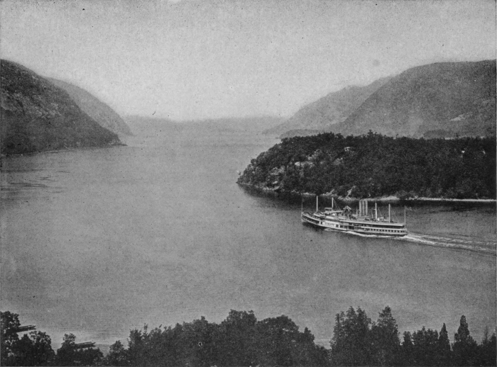
Copyright, 1905, by Detroit Publishing Company
THE HUDSON
The Hudson was divided by the old navigators into fourteen reaches, one of which, Claverack (Clover Reach), has survived. First came the Great Chip-Rock Reach (the Palisades); then the Tappan Reach where dwelt the Manhattans, the Saulrickans and the Tappans; the next reach ended at Haverstroo; following came Seylmaker’s Reach, Crescent Reach, Hoges Reach and Vorsen Reach which extended to Klinkersberg (Storm King). Fisher’s Reach, Claverack, Backerack, Playsier and Vaste Reach as far as Hinnenhock; then Hunter’s Reach to Kinderhook; and Fisher’s Hook near Shad Island, where dwelt the Mohegans.
No river in America presents so animated a scene as the Hudson from the Battery to the beginning of the Palisades. Ocean steamers, ferry-boats, excursion boats, private yachts, and craft of all sizes and kinds sail or steam down the narrow channel or cross between the shores of Manhattan and New Jersey. The river is always gay and beautiful in sunshine and fog, winter and summer.
On ascending the river, the first point of interest is Weehawken, on the west, where, on a narrow ledge of rock, Aaron Burr killed Alexander Hamilton in a duel, July 11, 1804. Next, and on the eastern shore, is Spuyten Duyvel Creek, associated with the earliest history of the river. This is a narrow stream formed by the in-flowing tide-water of the Hudson and joining at Kingsbridge with the so-called Harlem River, which is a similar in-flowing of the tide-water of Long Island Sound. Here a bridge was built in 1693; and here, on the 2d of October, Henry Hudson had a severe fight with the Indians who attacked the Half Moon. The origin of the name is unknown; but Irving’s legend clings to the spot as a limpet to a rock. He tells the story that the trumpeter, Antony van Corlear, was dispatched one evening on a message up the Hudson. When he arrived at this creek, the wind was high, the elements were in an uproar, and no boatman was at hand. He declared he would swim across en spijt en Duyvel (in spite of the Devil), but was drowned on the way.
Yonkers is the next point of interest on this side of the river, supposed to have derived its name from yonk-herr, the young heir. After passing Hastings and Dobbs Ferry (named after an old ferryman), the river widens into a beautiful bay. Across the river, opposite Spuyten Duyvel, is Fort Lee, from which Washington watched the battle that resulted in the loss of Fort Washington. From this point the Palisades begin. This range of rocks is from two hundred and fifty to six hundred feet high and extends about fifteen miles from Fort Lee to the hills of Rockland County.
Opposite Dobbs Ferry, the northern boundary line of New Jersey strikes the Hudson; and from this point north the river runs solely through the state of New York. At this point is Piermont; and near it Tappan, where André was hanged. Directly opposite Piermont is Irvington, twenty-four miles from New York, where close to the water’s edge stands Sunnyside, the charming home of Washington Irving, “made up of gable-ends and full of angles and corners as an old cocked hat,” to quote the description of the author, who bought and beautified an old Dutch dwelling called Wolfert’s Roost.
Three miles north is Tarrytown, a name derived from the Dutch Tarwen-Dorp, or wheat town, and not, as Diedrich Knickerbocker said, because husbands would tarry at the village tavern. A mile north of Tarrytown is the romantic Sleepy Hollow, where still stands the old Dutch Church. Six miles above Tarrytown and Sing Sing, now called by its original name, Ossin (a stone) and ing (a place) is reached. The name is derived from the rocky and stony character of the bank. Here the State Prison is situated.
Rockland and the old “tedious spot”—Verdietege Hook—of the old Dutch sailors are opposite, and a little above the latter, Diedrich Hook, or Point No Point. Croton River meets the Hudson about a mile above Sing Sing and forms Croton Bay. Croton Point, on which the Van Cortlandt Manor House stands, juts out here and separates Tappan Zee from Haverstraw Bay, and at the end of which, once called Teller’s Point, a great Indian battle is said to have taken place. The spot is haunted by the ghosts of warriors and sachems. Three miles more, and we reach Stony Point on the west; and, passing Verplanck’s Point on the east, come to Peekskill, where Nathan Palmer, the spy, was hanged. This was also the headquarters of General Israel Putnam.
Turning Kidd’s Point, or Caldwell’s landing, with Peekskill opposite, we pass through the “Southern Gate of the Highlands.” It is at this spot that Captain Kidd’s ship is supposed to have been scuttled. Here the Dunderberg, or Thunder Mountain rises abruptly from the river; and, as the latter turns to the west (now called for a brief time The Horse Race), another bold mass of rock, Anthony’s Nose (1,228 feet), looms into view.
On the other side of the river is Fort Montgomery Creek, once called Poplopen’s Kill, and here stood Fort Montgomery and Fort Clinton on either side of the mouth. From Fort Montgomery to Anthony’s Nose a chain of iron and wood was stretched across the river during the Revolutionary War to prevent the passage of British boats.
Opposite Anthony’s Nose is the Island of Iona; and now we see the Sugar Loaf, not one hill, as first appears, but a series of hills. At the foot of Sugar Loaf stood Beverly House, where Arnold lived at the time of his treason.
Half a mile below West Point, on the west side of the river, a small stream, rushing down the rocky precipice, forms a snowy cascade, known as Buttermilk Falls.
West Point, with its academy buildings and parade ground on a plateau two hundred feet above the river—the “Gibraltar of the Hudson”—near which may be seen the ruins of old Fort Putnam on Mount Independence, five hundred feet above the river, takes us into historic ground and beautiful scenery. We pass a succession of lofty hills on the same side of the river, the chief of which is Old Cro’ Nest (1,418 feet). Its name was given to it from a circular lake on the summit suggesting a nest in the mountains; and it is thus described by Rodman Drake, in the Culprit Fay:
“’Tis the middle watch of a summer night. The earth is dark, but the heavens are bright, The moon looks down on Old Cro’ Nest— She mellows the shade on his shaggy breast, And seems his huge grey form to throw In a silver cone on the wave below.”
To the north of Cro’ Nest comes Storm King, the highest peak of the Highlands (1,800 feet). First it was called Klinkersberg and then Boterberg (Butter Hill) and renamed Storm King by N. P. Willis. Storm King with Breakneck (1,187 feet), on the opposite side form the “Northern Gate of the Highlands.” The river here is deep and narrow as it cuts its way through what is practically a gorge in the Alleghany Mountains.
The Highlands now trend off to the north-east and the New Beacon or Grand Sachem Mountain (1,685 feet) and the Old Beacon (1,471 feet). The names are explained by the fact that signal fires were kindled on their summits during the Revolution. The Indians called them Matteawan and sometimes referred to the whole range of Highlands as Wequehachke (Hill Country). They also believed that the great Manito confined here rebellious spirits whose groans could often be heard.
On the west shore are situated the towns of Cornwall and Newburg, where Washington had his headquarters in the old Hasbrouck House.
Opposite Newburg is Fishkill Landing and above Newburg on the west side is the Devil’s Danskammer, or Devil’s Dancing Chamber, where the Indians celebrated their religious rites. Several villages and towns are passed on both sides of the river.
One spot of romantic interest on the west shore is Blue Point, where on moonlight nights a phantom ship is often seen at anchor beneath the bluff. It is supposed to be the Half Moon, which one day passed the Battery and sailed up the river without paying the slightest heed to signals. The “Storm Ship,” as she is called, is often seen in bad weather in the Tappan Zee and in Haverstraw Bay; but more frequently she appears at rest beneath the shadow of Blue Point.
Across the river is Poughkeepsie, so called from the Indian word Apokeepsing, meaning safe harbour. At this point is the only bridge that crosses the river between New York and Albany.
Six miles above Poughkeepsie, the river makes a sudden turn. The Dutch called this point Krom Elleboge (Crooked Elbow), now Crum Elbow. Ten miles further is Rhinebeck Landing, the approach to the old Dutch village of Rhinebeck, founded by William Beckman in 1647. On the opposite side of the river are Rondout and Kingston on Esopus Creek, which flows north and joins the Hudson at Saugerties.
North of Rhinebeck comes Lower Red Hook Landing or Barrytown, North Bay where the Clermont was built by Robert Fulton, and then Tivoli.
The next point of interest on the west side is Catskill Landing, just above the mouth of the Kaaterskill Creek. On the east bank is the city of Hudson; on the west bank Athens. Nearly opposite Four Mile Point Lighthouse is Kinderhook River or Creek on whose banks Martin Van Buren lived. Opposite Kinderhook is Coxsackie and above this New Baltimore and Coeymans. On the eastern bank are Schodack Landing, Castleton and Greenbush or East Albany. A bridge leads across to Albany on the west bank of the river. Six miles above Albany is the city of Troy, on the east bank. Above Cohoes on the west bank the Hudson receives the Mohawk, its largest tributary (150 miles long). Above Troy navigation is interrupted by many rapids and falls.
During the winter the river constantly freezes and it is not uncommon in the upper reaches to see skaters and sleighs crossing the ice. The breaking up of the ice is a marvellous spectacle.
In her Memoirs of an American Lady, Mrs. Grant of Laggan has vividly described this “sublime spectacle.” She notes that the whole population of Albany was down at the riverside in a moment when the first sound was heard like a “loud and long peal of thunder.” She writes:
“The ice, which had been all winter very thick, instead of diminishing, as might be expected in spring, still increased, as the sunshine came, and the days lengthened. Much snow fell in February, which, melted by the heat of the sun, was stagnant for a day on the surface of the ice, and then by the night frosts, which were still severe, was added, as a new accession to the thickness of it, above the former surface. This was so often repeated, that, in some years, the ice gained two feet in thickness, after the heat of the sun became such as one would have expected should have entirely dissolved it. So conscious were the natives of the safety this accumulation of ice afforded, that the sledges continued to drive on the ice when the trees were budding, and everything looked like spring; nay, when there was so much melted on the surface that the horses were knee-deep in water while travelling on it, and portentous cracks on every side announced the approaching rupture. This could scarce have been produced by the mere influence of the sun till midsummer. It was the swelling of the waters under the ice, increased by rivulets, enlarged by melted snows, that produced this catastrophe; for such the awful concussion made it appear. The prelude to the general bursting of this mighty mass, was a fracture, lengthways, in the middle of the stream, produced by the effort of the imprisoned waters, now increased too much to be contained within their wonted bounds. Conceive a solid mass, from six to eight feet thick, bursting for many miles in one continued rupture, produced by a force inconceivably great, and, in a manner, inexpressibly sudden. Thunder is no adequate image of this awful explosion, which roused all the sleepers, within reach of the sound, as completely as the final convulsion of nature, and the solemn peal of the awakening trumpet might be supposed to do. The stream in summer was confined by a pebbly strand, overhung with high and steep banks, crowned with lofty trees, which were considered as a sacred barrier against encroachments of this annual visitation. Never dryads dwelt in more security than those of the vine-clad elms, that extended their ample branches over this mighty stream. Their tangled roots, laid bare by the impetuous torrents, formed caverns ever fresh and fragrant; where the most delicate plants flourished, unvisited by scorching suns, or snipping blasts; and nothing could be more singular than the variety of plants and birds that were sheltered in these intricate and safe recesses. But when the bursting of the crystal surface set loose the many waters that had rushed down, swollen with the annual tribute of dissolving snow, the islands and lowlands were all flooded in an instant; and the lofty banks, from which you were wont to overlook the stream, were now entirely filled by an impetuous torrent, bearing down, with incredible and tumultuous rage, immense shoals of ice; which, breaking every instant by the concussion of others, jammed together in some places, in others erecting themselves in gigantic heights for an instant in the air, and seeming to combat with their fellow-giants crowding on in all directions, and falling together with an inconceivable crash, formed a terrible moving-picture, animated and various beyond conception; for it was not only the cerulean ice, whose broken edges, combating with the stream, refracted light into a thousand rainbows, that charmed your attention; lofty pines, large pieces of the bank torn off by the ice with all their early green and tender foliage, were driven on like travelling islands, amid this battle of breakers, for such it seemed. I am absurdly attempting to paint a scene, under which the powers of language sink.”
Since the days of the old Dutch settlers the Hudson has witnessed all the triumphs of modern ship-building and navigation. It was on the Hudson that Robert Fulton made his first experiments in steam navigation and into the Hudson have come the new turbine steamships that have crossed the Atlantic in five days; and beneath its waters tunnels have lately been opened.
Many changes have taken place on its banks since Washington Irving wrote: “I thank God that I was born on the banks of the Hudson. I fancy I can trace much of what is good and pleasant in my own heterogeneous compound to my early companionship with this glorious river. In the warmth of youthful enthusiasm, I used to clothe it with moral attributes, and, as it were, give it a soul. I delighted in its frank, bold, honest character; its noble sincerity and perfect truth. Here was no specious, smiling surface, covering the shifting sand-bar and perfidious rock, but a stream deep as it was broad and bearing with honourable faith the bark that trusted to its waves. I gloried in its simple, quiet, majestic, epic flow, ever straight forward, or, if forced aside for once by opposing mountains, struggling bravely through them, and resuming its onward march. Behold, thought I, an emblem of a good man’s course through life, ever simple, open and direct, or if, overpowered by adverse circumstances, he deviate into error, it is but momentary; he soon resumes his onward and honourable career, and continues it to the end of his pilgrimage.”