TURKEY IN EUROPE.*
Reading edition
TURKEY IN EUROPE.*

I.—GENERAL ASPECTS.
HE Balkan peninsula is, perhaps, that amongst the three great peninsulas of Southern Europe which enjoys the greatest natural advantages, and occupies the most favourable geographical position. In its outline it is far less unwieldy than Spain, and even surpasses Italy in variety of contour. Its coasts are washed by four seas; they abound in gulfs, harbours, and peninsulas, and are fringed by numerous islands. Several of its valleys and plains vie in fertility with the banks of the Guadalquivir and the plains of Lombardy. The floras of two climes intermingle on its soil, and add their charms to the landscape. The mountains of Turkey do not yield to those of the two other peninsulas in graceful outline or grandeur, and most of them are still covered with virgin forests. If they are less accessible than the Apennines of Italy or the sierras of Spain, that is owing simply to the want of roads; for they are, as a rule, of moderate elevation, and the plateaux from which they rise are narrower and more extensively intersected by valleys than is the table-land of Castile. Both Spain and Italy are closed in the north by mountain barriers difficult to cross, whilst the Balkan peninsula joins the continental trunk by almost imperceptible transitions, and nowhere is it separated from it by well-defined natural boundaries. The Austrian Alps extend without a break into Bosnia, and the Carpathians cross the Danube in order to effect a junction with the system of the Balkan. To the east of the “Iron Gate” there are no mountains at all, and Turkey is bounded there by the broad valley of the Danube. {88}

The proximity and parallelism of the coasts of two continents confer upon the Balkan peninsula an advantage unrivalled, perhaps, throughout the world. It is separated from Asia only by the narrow channel which joins the Black Sea to the Ægean Sea: this channel is an ocean highway, and yet forms no serious obstacle to the migration of nations from continent to continent. If the Black Sea were larger than it is at present; if it still formed one sea with the Caspian, and extended far into Asia, as it did in a past age, then Constantinople would necessarily become the great centre of the ancient world. That proud position was actually held by it a thousand years ago, and even if it should never recover it, its geographical position alone insures to it an importance for all time to come. If the city were to be razed to day, it would arise again to-morrow at some other spot in the neighbourhood. In the dawn of history powerful Ilion kept watch at the entrance of the Dardanelles: it survives in the city on the Bosphorus; and had there been no Byzantium, its mantle would have descended upon some other town in the same locality.
We know the part played by ancient Greece in the history of human culture. Macedonia and Thracia, the two other countries bordering upon the Ægean, have played their part too. It was those provinces which, after the invasion of the Persians, gave birth to the movement of reaction which led the armies of Alexander to the Euphrates and Indus. The power of the Romans survived there for a thousand years after Rome itself had fallen, and the precious germs of civilisation, which at a later period regenerated Western Europe, were nurtured there. It is true, alas ! that the Turk has put a stop to every enterprise of a civilising nature. These conquerors of Turanian race were carried into the Balkan peninsula in the course of a general migration of nations towards the west, which went on for three thousand years, and was attended by perpetual broils. It is now five hundred years since the Turks obtained a footing in the peninsula, and for more than four hundred years they have been its masters, and during that long period the old Roman empire of the East has been severed, as it were, from the rest of Europe. The normal progress of these highly favoured countries has been interrupted by incessant wars between Christians and Mohammedans, by the decay of the nations conquered or enslaved by the Turks, and by the heedless fatalism of the masters of the country. But the time is approaching when that important portion of Europe will resume the position due to it amongst the countries of the earth.
Vast tracts of the Balkan peninsula are hardly better known to us than the wilds of Africa. Kanitz found rivers, hills, and mountains figuring upon our maps which have no existence. Another traveller, Lejean, found that a pretended low pass through the Balkans existed only in the imagination. Russian geodesists engaged upon the measurement of an arc of a meridian found that Sofia, one of the largest and best-known cities of Turkey, had been inserted upon the best maps at a distance of nearly a day’s journey from its true position. The entire chain of the Balkans had to be shifted considerably to the south, in consequence of explorations carried on within the last few years. Men of science have hardly ventured yet to explore the plateaux of Albania or Mount Pindus, and much remains yet to {89} be done before our knowledge of the topography of the Balkan peninsula can be called even moderately complete. The voyages and explorations of a host of travellers24 have, however, made known to us its general features and its geological formations. Their task was by no means an easy one, for the mountain masses and mountain chains of the peninsula do not constitute a regular, well-defined system. There is no central range, with spurs running out on both sides, and gradually decreasing in height as they approach the plains. Nor is the centre of the peninsula its most elevated portion, for the culminating summits are dispersed over the country apparently without order. The mountain ranges run in all the directions of the compass, and we can only say, in a general way, that those of Western Turkey run parallel with the Adriatic and Ionian coasts, whilst those in the east meet the coasts of the Black Sea and the Ægean at right angles. The relief of the soil and the water-sheds make it appear almost as if Turkey turned her back upon continental Europe. Its highest mountains, its most extensive table-lands, and its most inaccessible forests lie towards the west and north-west, as if they were intended to cut it off from the shores of the Adriatic and the plains of Hungary, whilst all its rivers, whether they run to the north, east, or south, finally find their way into the Black Sea or the Ægean, whose shores face those of Asia.
This irregularity in the distribution of the mountains has its analogue in the distribution of the various races which inhabit the peninsula. The invaders or peaceful colonists, whether they came across the straits from Asia Minor, or along the valley of the Danube from Scythia, soon found themselves scattered in numerous valleys, or stopped by amphitheatres having no outlet. They failed to find their way in this labyrinth of mountains, and members of the most diverse races settled down in proximity to each other, and frequently came into conflict. The most numerous, the most warlike, or the most industrious races gradually extended their power at the expense of their neighbours; and the latter, defeated in the struggle for existence, have been scattered into innumerable fragments, between which there is no longer any cohesion. Hungary has a homogeneous population, if we compare it with that of Turkey; for in the latter country there are districts where eight or ten different nationalities live side by side within a radius of a few miles.
Time, however, has brought some order into this chaos, and commercial intercourse has done much to assimilate these various races. Speaking broadly, Turkey in Europe may now be said to be divided into four great ethnological zones. The Greeks occupy Crete, the islands of the Archipelago, the shores of the Ægean Sea, and the eastern slopes of Mounts Pindus and Olympus; the Albanians hold the country between the Adriatic and Mount Pindus; the Slavs, including Servians, Croats, Bosnians, Herzegovinians, and Tsernagorans (Montenegrins), occupy the Illyrian Alps, towards the north-west; whilst the slopes of the Balkan, the Despoto Dagh, and the plains of Eastern Turkey belong to the Bulgarians, who, as far as language goes, are Slavs likewise. As to the Turks, the lords of the land, {90} they are to be met with in most places, and particularly in the large towns and fortresses; but the only portion of the country which they occupy to the exclusion of other races is the north-eastern corner of the peninsula, bounded by the Balkans, the Danube, and the Black Sea.
II.—CRETE AND THE ISLANDS OF THE ARCHIPELAGO.
Crete, next to Cyprus, is the largest island inhabited by Greeks. It is a natural dependency of Greece, but treaties made without consulting the wishes of the people have handed it over to the Turks. It is Greek in spite of this, not only because the majority of its inhabitants consider it to be so, but also because of its soil, its climate, and its geographical position. On all sides it is surrounded by deep seas, except towards the north-west, where a submarine plateau joins it to Cythera and the Peloponnesus.
There are few countries in the world more favoured by nature. Its climate is mild, though sometimes too dry in summer; its soil fertile in spite of the waters being swallowed up by the limestone rocks; its harbours spacious and well sheltered; and its scenery exhibits both grandeur and quiet beauty. The position of Crete, at the mouth of the Archipelago, between Europe, Asia, and Africa, seems to have destined that island to become the great commercial emporium of that part of the world. Aristotle already observed this, and, if tradition can be trusted, Crete actually held that position for more than three thousand years. During that time it “ruled the waves;” the Cyclades acknowledged the sway of Minos, its king; Cretan colonists established themselves in Sicily; and Cretan vessels found their way to every part of the Mediterranean. But the island unfortunately became divided into innumerable small republics jealous of each other, and was therefore unable to maintain this commercial supremacy in the face of Dorian and other Greeks. At a subsequent period the Romans subjected the island, and it never recovered its independence. Byzantines, Arabs, Venetians, and Turks have held it in turn, and by each of them it has been laid waste and impoverished.
The elongated shape of the island, and the range of mountains which runs through it from one extremity to the other, enable us to understand how it was that at a time when most Greeks looked upon the walls of their cities as synonymous with the limits of their fatherland, Crete became divided into a multitude of small republics, and how every attempt at federation (“syncretism”) miserably failed. The inhabitants, in fact, were more effectually separated from each other than if they had inhabited a number of small islands forming an archipelago. Most of the coast valleys are enclosed by high mountains, the only easy access to them being from the sea, and communications between the towns occupying their centres are possible only by crossing difficult mountain paths easily defended. In all Crete there exists but one plain deserving the name, viz. that of Messara, to the south of the central mass of mountains. It is the granary of the island, and the Ieropotamo, or “holy river,” which traverses it, has a little water even in the middle of summer. {91}
The contour of Crete corresponds in a remarkable manner with the height of its mountains. Where these are high, the island is broad; where they sink down, it is narrow. In the centre of the island rises Mount Ida (Psiloriti), where Jupiter was educated by the Corybantes, and where his tomb was shown. Its lofty summit, covered with snow almost throughout the year, its gigantic buttresses, and the verdant valleys at its base render it one of the most imposing mountains in the world; but it was still more magnificent in the time of the ancient Greeks, when forests covered its slopes, and justified its being called Mount Ida, or “the wooded.” On the summit of this mountain the whole island lies spread out beneath our feet; the horizon towards the north, from Mount Taygetus to the shores of Asia, is dotted with islands and peninsulas; and in the south a wide expanse of water extends beyond the barren and inhospitable island of Gaudo.
Fig. 28.—THE GORGE OF HAGIO RUMELI.
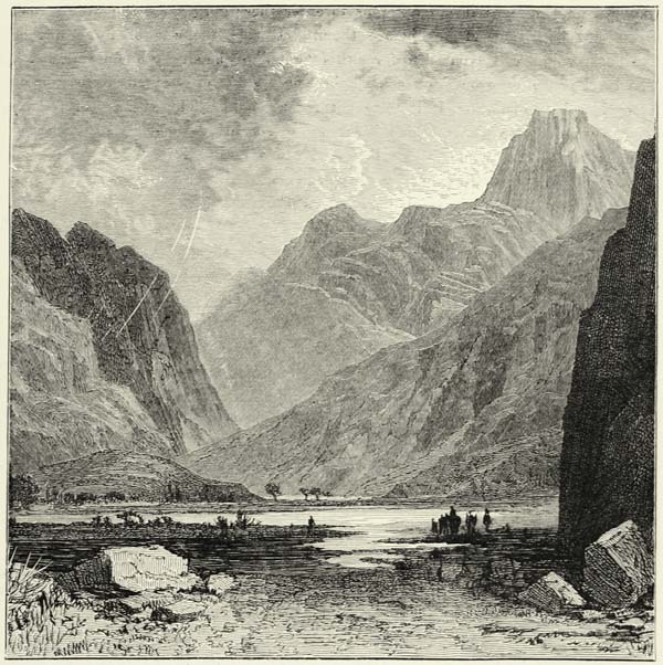
The Leuca-Ori, or “White Mountains,” in the western extremity of the island, are thus called on account of the snow which covers their summits, or because {92} of their white limestone cliffs. They are exceedingly steep, and perfectly bare, hardly any verdure being met with even in the valleys at their foot. They are known, also, as the Mountains of the Sphakiotes, the descendants of the ancient Dorians, who have retired into their fastnesses, where they are protected by nature against every attack. Some of their villages are accessible only by following the stony bed of mountain torrents leaping down from the heights in small cascades. During the rains the water rushes down these ravines in mighty torrents. The “gates are closed” then, as it is said. One of these gates, or pharynghi, is that of Hagio Rumeli, on the southern slope of the Leuca-Ori. When rain threatens it is dangerous to enter these gorges, for the waters rush down and carry everything before them. During the war of independence the Turks vainly endeavoured to force this “gate” of the strong mountain citadel. The level pieces of ground on these heights are sufficiently extensive to support a considerable population, if it were not for the cold. The villages of Askyfo occupy one of these plains, which is surrounded on all sides by an amphitheatre of mountains. In former times this cavity was occupied by a lake. This is proved by ancient beaches and by other evidence. But the waters of the lake found an outlet through some katavothras (khonos, “sinks”) and discharged themselves into the sea.
The remaining mountains of the island are less elevated and far less sterile than the White Mountains. The most remarkable amongst them are the Lasithi, and, still farther west, those of Dicte, or Sitia, a sort of pendant to the Mountains of the Sphakiotes. Raised sea-beaches have been traced along their northern slopes, covered with shells of living species, and they prove that that portion of the island has been upheaved more than sixty feet during a recent geological epoch. The northern coast, between the White Mountains and Mount Dicte, offers a greater variety of contour than does the south coast. Its capes, or acroteria, project far into the sea, and thence are gulfs, bays, and secure anchorages. For these reasons most commercial cities have been built upon that side of the island, which faces the Archipelago and presents a picture of life, whilst the south coast, facing Africa, is comparatively deserted. All the modern cities on the northern coasts have been built upon the sites of ancient ones. Megalokastron, better known by its Italian name of Candia, is the Heracleum of the ancients, the famous haven of Cnossus. Retimo, on the western front of Mount Ida, is easily identified with the ancient Rithymna; whilst Khanea (Canea), whose white houses are almost confounded with the arid slopes of the White Mountains, represents the Cydonia of the Greeks, famous for its forests of quince-trees. Canea is the actual capital, and although not the most populous, it is nevertheless the most important and the busiest city of the island. It has a second haven to the east, Azizirge, on Suda Bay, one of the best sheltered on the island, and promises to become one of the principal maritime stations on the Mediterranean.25 {93}
Crete has certainly lost much in population and wealth, and the epithet of the “isle of a hundred cities,” which it received from the ancient Greeks, no longer applies to it. Miserable villages occupy the sites of the ancient cities, their houses built from the materials of a single ruined wall, whilst immense quarries had to be opened in order to supply the building materials required in former times. The famous “labyrinth” is one of the most considerable of these ancient quarries. Crete, in spite of its great fertility, exports merely a few agricultural products, and nothing now reminds us of the fruitful island upon which Ceres gave birth to Plutus. The peasants are the reputed owners of the land, but they take little heed of its cultivation. Their olives yield only an inferior oil, and though the wine they make is good in spite of them, it is no longer the Malvoisie so highly prized by the Venetians. The cultivation of cotton, tobacco, and of fruit of all sorts is neglected. The only progress in agriculture which can be recorded during the present century consists in the introduction of orange-trees, whose delicious fruit is highly appreciated throughout the East. M. Georges Perrot has drawn attention to the singular fact that, with the exception of the olive-trees and the vine, the cultivated trees of the island are confined to particular localities. Thus chestnuts are met with only at the western extremity of the island; vigorous oaks and cypresses are confined to the elevated valleys of the Sphakiotes; the valonia oaks are met with only in the province of Retimo; Mount Dicte alone supports stone-pines and carob-trees; and a promontory in South-eastern Crete, jutting out towards Africa, is surmounted by a grove of date-trees—the finest throughout the Archipelago.
Fig. 29.—CRETE, OR CANDIA.
Scale 1 : 2 470,000.
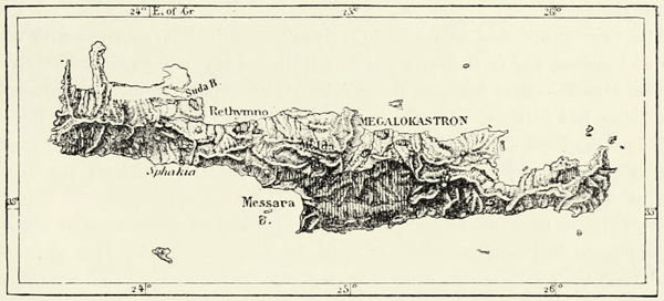
The district inhabited by Mohammedans is shaded vertically.
The inhabitants of Crete and the neighbouring islets are still Greek, in spite of successive invasions, and they still speak a Greek dialect, recognised as a corrupted Dorian. The Slavs, who invaded the island during the Middle Ages, have left no trace except the names of a few villages. The Arabs and Venetians, too, have been assimilated by the aboriginal Cretans; but there still exist a considerable {94} number of Albanians, the descendants of soldiers, who have retained their language and their customs. As to the Mohammedans or pretended Turks, who constitute about one-fifth of the total population, they are, for the most part, the descendants of Cretans who embraced Islamism in order to escape persecution. They are the only Hellenes throughout the East who have embraced, in a body, the religion of their conquerors; but since religious persecution has subsided several of those Mohammedan Greeks have returned to the religion of their ancestors. The Greeks of Crete are thus not only vastly in the majority, but they hold the first place also in industry, commerce, and wealth; it is they who buy up the land, and the Mohammedan gradually retires before them. All Cretans, with the exception of the Albanians, speak Greek, and only in the capital and in a portion of Messara, where the Mohammedans live in compact masses, has the Turkish language made any progress.
We need not be surprised, therefore, if the Greeks lay claim to a country in which their preponderance is so marked. But, in spite of their valour, they were no match against the Turkish and Egyptian armies which were brought against them.
The Cretans are said to resemble their ancestors in the eagerness with which they do business, and in their disregard of truth. They may possibly be “Greeks amongst Greeks—liars amongst liars;” but they certainly cannot be reproached with being bad patriots. On the contrary, they have suffered much for the sake of their fatherland, and during the war of independence their blood was shed in torrents on many a battle-field. The vast cavern of Melidhoni, on the western slope of Mount Ida, was the scene of one of the terrible events of this war. In 1822 more than three hundred Hellenes, most of them women, children, and old men, had sought refuge in this cavern. The Turks lit a fire at its mouth, and the smoke, penetrating to its farthest extremity, suffocated the unfortunate beings who had hoped to find shelter there.
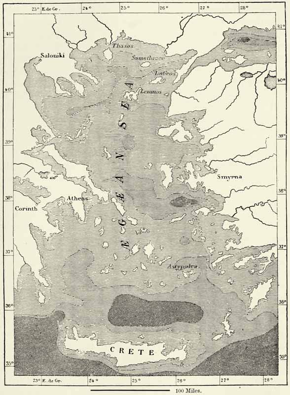
The profound “Sea of Minos,” to the north of Crete, separates that island from the Archipelago. All the islands of the latter have been assigned to the kingdom of Greece—Astypalæa, vulgarly called Astropalæa or Stampalia, alone excepted, which still belongs to the Turks. The ancients called this island the “Table of the Gods,” although it is only a barren rock. It clearly belongs to the eastern chain of the Cyclades, as far as geological formation and the configuration of the sea-bottom go; but the diplomats allowed its fifteen hundred inhabitants to remain under the dominion of Turkey.
Amongst the other islands inhabited by Greeks, but belonging to Turkey, Thasos is that which lies nearest to the coast of Europe. The strait which separates it from Macedonia is hardly four miles across, and in its centre there is an island (Thasopulo), as well as several sand-banks, which interfere much with navigation. Though a natural dependency of Macedonia, this island is governed by a mudir of the Viceroy of Egypt, to whom the Porte made a present of it. When Mohammed II. put an end to the Byzantine empire, Thasos and the {95} neighbouring islands formed a principality, the property of the Italian family of the Gateluzzi.
Fig. 30.—THE ÆGEAN SEA.
According to Robiquet. Scale, 1 : 5,170,000.
Μ
The map is shaded to express the depth of the sea. The palest tint indicates a depth of less than 55 fathoms; the next tint a depth of 55 to 275 fathoms; the next a depth of 275 to 550 fathoms; and the darkest tint a depth of over 550 fathoms.
Thasos is one of those countries of the ancient world the present condition of which contrasts most unfavourably with former times. Thasos, an ancient Phœnician colony, was once the rival, and subsequently the wealthy and powerful ally, of Athens: its hundred thousand inhabitants worked the gold and iron mines of {96} the island; they quarried its beautiful white marble; cultivated vineyards yielding a famous wine; and extended their commercial expeditions to every part of the Ægean Sea. But now there are neither mines nor quarries, the vines yield only an inferior product, the agricultural produce hardly suffices for the six thousand inhabitants of the island, and the ancient haven of Thasos is frequented only by the tiniest of vessels. The island has recovered very slowly from the blow inflicted upon it by Mohammed II., who carried nearly the whole of its inhabitants to Constantinople. Thasos after this became a haunt of pirates, and its inhabitants sought shelter within the mountains of the interior. They are Hellenes, but their dialect is very much mixed with Turkish words. Unlike other Hellenes, they are not anxious to improve their minds. They are degenerate Greeks, and they know it. “We are sheep and beasts of burden,” they’ repeatedly told the French traveller, Perrot.
Thasos, however, is the only island of the Archipelago where wooded mountains and verdant landscapes survive. Rains are abundant, and its vegetation luxuriant. Running streams of water murmur in every valley; large trees throw their shade over the hill-sides; the villages near the foot of the mountain are hidden by cypresses, walnut, and olive-trees; the valleys which radiate in all directions from the centre of the island abound in planes, laurels, yoke-elms, and vigorous oaks; and dark pine forests cover the higher slopes of the hills, the glittering barren summits of Mount St. Elias and of other high mountains alone rising above them.
Samothrace, though smaller than Thasos, is much more elevated. Its mountains are composed of granite, schists, limestones, and trachyte, and form a sort of pendant to Mount Athos, on the other side of the Ægean Sea. If we approach Samothrace from the north or the south, it presents the appearance of a huge coffin floating upon the waters; from the east or west its profile resembles a pyramid rising from the waves. From its summit Neptune watched the fight of the Greeks before Troy. In the dark oak forests of the Black Mountains were carried on the mysteries of Cybele and her Corybantes, as well as the Cabiric worship, which was intimately connected with them, and Samothrace was to the ancient Greeks what Mount Athos is to the moderns—a sacred land. Numerous ruins and inscriptions remain to bear witness to the zeal of devout travellers from all parts of the world. But with the downfall of the heathen temples the pilgrims disappeared. There is only one village on the island now. Its inhabitants lead a secluded life, and the only strange faces they see are those of the sponge-fishers who frequent the island during summer. The entire absence of harbours, and the dangerous current which separates Samothrace from Imbro, keep off the mariner, and though the valleys are extremely fertile, they have not hitherto attracted a single immigrant from the neighbouring continent.
Imbro and Lemnos are separated from Samothrace by a deep sea, and appear to continue the range of the Thracian Chersonesus. Imbro, which is nearest to the continent, is the more elevated of the two islands, but its St. Elias does not attain half the height of the mountains of Samothrace. There are no forests {97} upon the slopes of this mountain, the valleys are covered with stones, and hardly an eighth of the surface of the island is capable of cultivation. Still, the position of Imbro, close to the mouth of the Dardanelles and upon an international ocean highway, will always secure to it a certain degree of importance. The majority of the inhabitants live in a small valley in the north-eastern portion of the island, and though the rivulet which flows through this valley regularly dries up in summer, it is nevertheless called emphatically the Megalos Potamos, or “big river.”
Lemnos, or Limni, is the largest island of Thracia, and at the same time the least elevated and the most barren. You may walk for hours there without seeing a tree. Even olive-trees are not met with in the fields, and the village gardens can boast but of few fruit trees. Timber has to be procured from Thasos or the continent. Lemnos, in spite of all this, is exceedingly fertile; it produces barley and other cereals in plenty, and the pastures amongst its hills sustain 40,000 sheep. The island consists of several distinct mountain groups of volcanic origin, 1,200 to 1,500 feet in height, and separated by low plains covered with scoriæ, or by gulfs penetrating far inland. In the time of the ancient Greeks the volcanoes of Lemnos had not yet quenched their fires, for it was in one of them that Vulcan, when hurled from heaven, established his smithy, and, with the assistance of the Cyclops, forged his thunderbolts for Jupiter. About the beginning of our era Mount Mosychlos and the promontory of Chryse were swallowed up by the sea, and the vast shoals which extend from the eastern part of the island in the direction of Imbro probably mark their site. Since the disappearance of Mount Mosychlos, Lemnos has not again suffered from volcanic eruptions or earthquakes. The majority of the inhabitants are Greeks, and the Turks who have settled amongst them are being evicted by the conquered race, which is superior to them in intelligence and industry. Commerce is entirely in the hands of the Greeks. Its principal seat is at Kastro—the ancient Myrhina—which occupies a headland between two roadsteads. Sealed earth is one of the articles exported, and is found in the mountains. In ancient times it was much prized as an astringent, and is so still throughout the East. It is not considered to possess its healing qualities unless it has been collected before sunrise on Corpus Christi day.
The small island of Stratio (Hagios Eustrathios) depends politically and commercially upon Lemnos. It, too, is inhabited by Greeks. As to the islands along the coast of Asia Minor, they form a portion of Turkey in Europe as far as their political administration is concerned, but geographically they belong to Asia.26 {98}
III.—TURKEY OF THE GREEKS (THRACIA, MACEDONIA, AND THESSALY).
The whole of the Ægean seaboard of European Turkey is occupied by Greeks, and this proves the great influence which the sea has exercised upon the migrations of the Mediterranean nations. Thessaly, Macedonia, Chalcis, and Thrace are more or less Greek countries, and even Constantinople lies within Greece, as defined by ethnological boundaries. The geographical distribution of race there does not, in fact, coincide with the physical features of the country—its mountains, rivers, and climate. The Turkey of the Greeks is, in reality, no geographical unit, and the only tie which unites it are the waters of the Archipelago, which wash all its shores.
Nowhere else does the Balkan peninsula exhibit such varied features as on the shores of the Ægean Sea, and of the adjoining basin of the Sea of Marmara. Bluffs, hills, and mountain masses rise abruptly from the plain; arms of the sea extend far inland; and ramified peninsulas project into the deep waters of the ocean. It appears almost as if nature were making an effort to create an archipelago similar to that in the south.
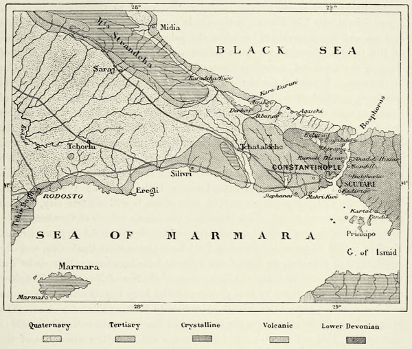
The tongue of land upon which Constantinople has been built offers a remarkable example of the features which characterize the coast lands of this portion of Europe. Geologically the whole of this peninsula belongs to Asia. Its hollow hills are separated from the granitic mountains of Europe by a wide plain covered with recent formations, and the wall of Athanasius, now in ruins, which was built as a defence to the city, approximately marks the true boundary between Europe and Asia. The rocks on both sides of the Bosphorus belong to the Devonian formation. They contain the same fossils, exhibit the same outward aspects, and date from the same epoch. A patch of volcanic rocks at the northern entrance to the Bosphorus likewise exhibits the same characteristics on both sides of the strait, and there cannot be the least doubt that this European peninsula at a former epoch constituted a portion of Asia Minor, but was severed from it by an irruption of the waters.
Μ
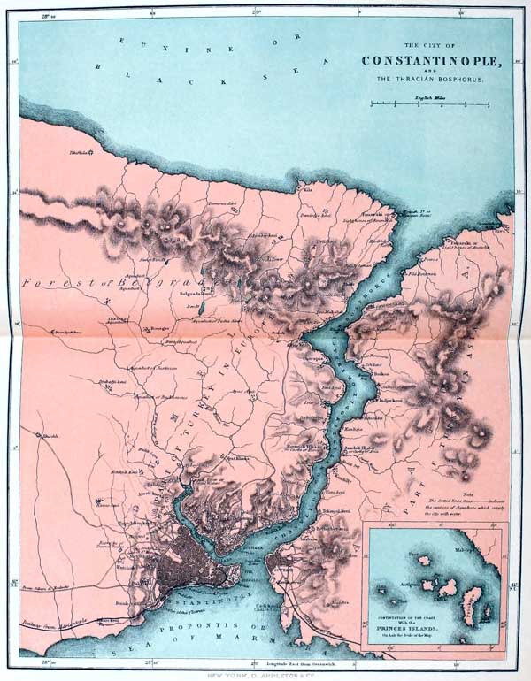
THE CITY OF CONSTANTINOPLE, AND THE THRACIAN BOSPHORUS.
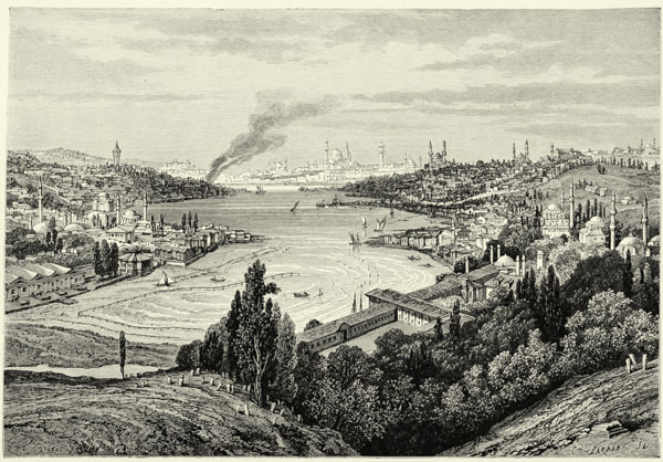
CONSTANTINOPLE AND THE GOLDEN HORN, FROM THE HEIGHTS OF EYUB.
Apollo himself, it is said, pointed out the site where to build the city which is now known as Constantinople, and no better could have been found. In fact, the city occupies the most favoured spot on the Bosphorus. It stands on a peninsula of gently undulating hills, bounded by the Sea of Marmara and by the curved inlet called, from its shape, its beauty, and the valuable cargoes floating upon its waters, the “Golden Horn.” The swift current of the Bosphorus penetrates into this inlet, and sweeps it clean of all the refuse of the city. It then passes into the open sea at the extreme angle of the peninsula, and sailing vessels are thus able to reach their anchorage without having to struggle against a contrary current. This haven not only affords a secure anchorage to a multitude of vessels, but it likewise abounds in fish; for, in spite of the constant agitation of its waters by the oars of caiques and the paddles or screws of steamers, it is visited annually by shoals of tunnies and other fish. The haven of Constantinople, though easy of access to peaceable merchantmen, can readily be {99} closed in case of war. The surrounding heights command every approach to it, and a chain has more than once been drawn across the narrow entrance to its roadstead when the city was besieged. The latter, too, can be defended easily, for it is built upon hills, bounded on the land side by an extensive plain. An assailant, to insure success, must dispose not only of an army, but also of a powerful navy. In addition to all these natural advantages of its site, Constantinople is in the enjoyment of a climate far superior to that of the cities of the Black Sea, for it is screened by hills from cold northerly winds.
Μ
Fig. 31.—GEOLOGICAL MAP OF THE PENINSULA OF CONSTANTINOPLE.
According to F. von Hochstetter. Scale 1 : 1,370,000.
In the dawn of history, when migration and commerce marched only at a slow pace, a site as favoured as that of Byzantium was capable only of attracting the dwellers in its immediate neighbourhood. But after commerce had become developed, the blind alone—so said the oracle of Apollo—could fail to appreciate the great advantages held out by the Golden Horn. Indeed, Constantinople lies not only on the ocean highway which connects the world of the Mediterranean with the Black Sea, but also on the high-road which leads from Asia into Europe. Geographically it may be described as occupying a position at {100} the mouths of the Danube, Dniester, Dnieper, Don, Rion, and Kizil Irmak, whose common outlet is the Bosphorus. When Constantine the Great constituted it the metropolis of the Roman empire, it grew rapidly in population and wealth; it soon became the city of cities; and its Turkish appellation, Stamboul, is nothing but a corruption of the expression es tam polin, used by the inhabitants to denote their going into the city. Amongst the distant tribes of Asia it represents Rome. They know it by no other name than that of “Rum,” and the country of which it is the capital they call “Rumelia.”
Constantinople is one of the most beautiful cities in the world: it is the “paradisiacal city” of Eastern nations. It may compare with Naples or Rio de Janeiro, and many travellers accord it the palm. As we approach the entrance of the Golden Horn, seated in a caique more graceful than the gondolas of Venice, the vast and varied panorama around us changes with every stroke of the oars. Beyond the white walls of the Seraglio and its masses of verdure rise here, amphitheatrically on the seven hills of the peninsula, the houses of Stamboul—its towers, the vast domes of its mosques, with their circlets of smaller domes, and its elegant minarets, with their balconies. On the other side of the haven, which is crossed by bridges of boats, there are more mosques and towers, seen through a forest of masts and rigging, and covering the slope of a hill whose summit is crowned by regularly built houses and the palatial residences of Pera. On the north vast villa-cities extend along both shores of the Bosphorus. Towards the east, on a promontory of Asia, there is still another city, cradled amidst gardens and trees. This is Scutari, the Asiatic suburb of Constantinople, with its pink houses and vast cemetery shaded by beautiful cypress groves. Farther in the distance we perceive Kadi-koei, the ancient Chalcedon, and the small town of Prinkipo, on one of the Princes’ Islands, whose yellow rocks and verdant groves are reflected in the blue waters of the Sea of Marmara. The sheet of water connecting these various portions of the huge city is alive with vessels and boats, whose movements impart animation to the magnificent picture. The prospect from the heights above the town is still more magnificent. The coasts of Europe and Asia are beneath our feet, the eye can trace the sinuosities of the Bosphorus, and far away in the distance looms the snow-capped pyramidal summit of Mount Olympus, in Bithynia.
But this enchantment vanishes as soon as we penetrate into the streets of Constantinople. There are many parts of the town with narrow and filthy streets, which a stranger hesitates to enter. It is, perhaps, a blessing, from a sanitary point of view, that conflagrations so frequently lay waste and scour large portions of the city. Scarcely a night passes without the watchman on the tower of the Seraskieriate giving the alarm of fire, and thousands of houses are devoured by that element every year. The city thus renews itself by degrees. It rises from its ashes purified by the flames. But formerly, before the Turks had built their city of stone on the heights of Pera, the quarters destroyed by fire were rebuilt as wretchedly as they were before. It is different now. The use of stone has become more general; wooden structures are being replaced by houses built {101} of a fossiliferous white limestone, which is quarried at the very gates of the city; and free use is made of the blue and grey marbles of Marmara, and of the flesh-coloured ones of the Gulf of Cyzica, in Asia Minor, in decorating the palaces of the great.
Nearly every vestige of the monuments of ancient Byzantium has been swept away by fires or sieges. There only exists now the precious tripod of bronze, with its three serpents, which the Platæans had placed in the temple of Delphi in commemoration of their victory over the Persians. The relics of the epoch of the Byzantine emperors are limited to columns, obelisks, arches of aqueducts, the breached walls of the city, the remains of the palace of Justinian, only discovered recently, and the two churches of Santa Sophia, which have been converted into mosques. The grand church of Santa Sophia, close to the Seraglio, is no longer the most magnificent edifice in the universe, as it was in the time of Justinian, for even the neighbouring mosque of Sultan Ahmed far exceeds it in beauty and elegance. It is a clumsy building, supported by buttresses added at various times to keep it from falling. The character of the interior has been changed by the Turks, who have introduced additional pillars, and the once bright mosaics have been covered over; but the dome never fails to strike the beholder: it is a marvel of strength and lightness.
The Seraglio, or Serai, near Garden Point, may boast of fine pavilions and shady walks, but the dark memories of crime will always cling to it. The spot from which sacks containing the bodies of living sultanas or odalisks were hurled into the dark waters of the Bosphorus is still pointed out to the traveller. Far more attractive than this ancient residence of the sultans are the marvellous structures in the Arab or Persian style which line the shores of the Bosphorus, and which impart to the suburbs of Constantinople an aspect of oriental splendour.
The bazaars are amongst the most curious places in the city, not so much because of the rich merchandise which is displayed in them, but because they are frequented by a variety of nations such as cannot be met with in any other city of the world. The capital of the Ottoman empire is a centre of attraction not only to the inhabitants of the Balkan peninsula, but also to those of Anatolia, Syria, Arabia, Egypt, Tunis, and even of the oases. There are “Franks” from every country of Europe, drawn thither by a desire to share in the profits of the ever-increasing commerce of the Bosphorus. This mixture of races is rendered still greater by the surreptitious importation of slaves; for, whatever diplomatists may assert, there can be no doubt that the “honourable guild of slave-dealers” still does an excellent business in negresses, Circassians, and white and black eunuchs. Nor is anything else to be expected amongst a people who look upon a well-stocked harem as a sign of respectability. Dr. Millingen estimates the number of slaves at Constantinople at 30,000 souls, most of whom have been imported from Africa. From an anthropological point of view it is certainly very remarkable that the negro should not have taken root in Constantinople. In the course of the last four centuries a million of negroes at least have been imported, and yet, owing to difficulties of acclimation, ill-usage, and want, they would die out but for fresh importations. {102}
Our statistics do not enable us to classify the 600,000 inhabitants of Constantinople and its suburbs according to race.27 One of the principal sources of error in estimates of this kind consists in our confounding Mussulmans with Turks. In the provinces it is generally possible to avoid this error, for Bosnians, Bulgarians, and Albanians recognise each other as members of the same race, whatever religious differences may exist between them. But in the turmoil of a great city this distinction is no longer made, and, in the end, all those who frequent the mosques are lumped together as if they were members of the same race. Of the supposed Osmanli of Constantinople a third, perhaps, consists of Turks, whilst the remaining two-thirds are made up of Arnauts, Bulgarians, Asiatics, and Africans of various races. Amongst the boatmen there are many Lesghians from the Caucasus. The Mohammedans, if not in the minority already, will be so very soon, for they lose ground almost visibly. In old Stamboul, in which a Frank hardly dared to enter some twenty years ago, they still enjoy a numerical preponderance, but in the “agglomeration of cities” known as Constantinople, and extending from Prinkipo to Therapia, they are outnumbered by Greeks, Armenians, and Franks, and certain quarters of the town have been given up to the Christians altogether.
The Greeks are the most influential, and perhaps most numerous, element amongst the rayas. Their head-quarters, like those of the Turks, are at Stamboul, where they occupy a quarter of the town called Phanar, from an old lighthouse. The Greek patriarch and the wealthiest Greek families reside there. These Phanariotes, in former times, almost monopolized the government of the Christian provinces of Turkey, but they fell into disfavour after the Greek war of liberation. The religious influence, too, which they exercised until quite recently, has been destroyed in consequence of the separation of the Servian, Rumanian, and Bulgarian Churches from the orthodox Greek Church—a separation brought about almost entirely through the rapacity of the Greek patriarch and his satellites. If the Greeks would continue to preserve their pre-eminence amongst the races of Constantinople, they must trust, in the future, to their superior intelligence, their commercial habits, education, patriotism, and unanimity. To the Turks the members of the orthodox Church are known as the “Roman nation,” and they enjoy a certain amount of self-government, exercised through their bishops, which extends to marriages, schools, hospitals, and a few other matters.
The “nation” of the Armenians is likewise very strong at Constantinople, and, like that of the “Romans,” it governs itself through an elective Executive Council. Much of the commerce of Constantinople passes through the hands of Armenians, who, though they came to that city almost simultaneously with the Turks, have down to the present day preserved their peculiar manners. They are cold and reserved, and full of self-respect, differing widely from their rivals in trade, the Jews, who slink furtively to their poor suburb of Balata, at the upper {103} extremity of the Golden Horn. The Armenians are clannish in the extreme, they readily assist each other, and, like the Parsees of Bombay, delight in acts of munificence. But, unlike the Greeks, they are not sustained in their undertakings by an ardent belief in the destinies of their race. Most of them are not even able to speak their native language freely, and prefer to converse in Turkish or Greek.
The Franks are much inferior in number to either of the races named, but their influence is nevertheless far more decisive. It is through them that Constantinople is attached to the civilisation of Western Europe, and their institutions are by degrees getting the better of the fatalism of the East. It is they who built the manufacturing suburbs to the west of Constantinople and near Scutari, and who introduced railways. Every civilised nation of the world is represented amongst them—Italians and French most numerously; and to the Americans is due the credit of having established the first geological museum in Turkey, in connection with Robert Colleg.
Constantinople, owing to the influx of strangers, is steadily increasing in population, and one by one the villages in its vicinity are being swallowed up by the city. The whole of the Golden Horn is surrounded by houses now, and they extend far up the valleys of the Cydaris and Barbyzes, which fall into it. Industrial establishments extend along the shores of the Sea of Marmara, from the ancient fort of the Seven Towers far to the west, and from Chalcedon to the south-east, in the direction of the Gulf of Nicomedia. Both banks of the Bosphorus are lined with villas, palaces, kiosks, cafés, and hotels. This remarkable channel extends for nineteen miles between the shores of Europe and of Asia.28 Like a huge mountain valley it winds between steep promontories, now contracting and then expanding, until it finally opens out into the vast expanse of the Black Sea. When northern winds hurl the agitated waters of the latter against the sombre cliffs which guard the entrance to the Bosphorus, the contrast between this savage sea and the placid waters of the strait and its charming scenery is striking indeed. At every turn we are arrested by unexpected charms. Rocks, palaces, woods, vessels of every description, and the curious scaffoldings of Bulgarian fishermen succeed each other in infinite variety.
Amongst the innumerable country residences which nestle on the shores of the Bosphorus, those of Balta-Liman, Therapia, and Buyukdere are the best known, for they have been the scenes of historical events; but there is no spot throughout this marine valley which does not excite admiration. These marvels of nature will, before long, have added to them a marvel of human ingenuity. The width of the channel between the castles of Rumili and Anadoli is only 600 yards. It was here Mandroclus of Samos constructed the bridge of boats across which Darius marched his army of 700,000 men when he made war upon the Scythians, and on this identical spot it is proposed now to construct a railway bridge which will join the railways of Europe to those of Asia. A current runs through the Bosphorus, from the Black Sea to the Sea of Marmara, at a rate of from two to six miles an hour; and although several geographers conclude from this that the level {104} of the former is higher than that of the latter, this must by no means be looked upon as an established fact. We have already noticed the exchange between the waters of the Mediterranean and of the open Atlantic, which takes place through the Strait of Gibraltar. A similar exchange is going on here, and the outflowing surface current is compensated for by an inflowing under-current.
The outlying houses and villas of Constantinople extend northwards along the Bosphorus as far as the two Genoese castles of Rumili-kavak and Anadoli-kavak. This extension coincides with the geological features of the ground, for no sooner have we turned our backs upon the houses than we find ourselves shut in between cliffs of dolerite and porphyry, which extend as far as the Black Sea, where they terminate in the precipices of the Cyaneæ, or Symplegades, the famous rocks which opened and shut, crushing the vessels that ventured to pass through the strait, until Minerva fixed them for ever. These volcanic rocks are barren, but the Devonian strata to the south of them are beautifully wooded. The Turks, unlike the Spaniards and other Southern nations, love and respect nature; plane-trees, cypresses, and pines still shade the shores of the Bosphorus; and the vast forest of Belgrade covers the hills to the east of Constantinople, from which the city draws its supply of water. Birds, too, are better protected than in many a Christian land. The plaintive cooing of doves is heard wherever we turn, flights of swallows and aquatic birds skim over the surface of the Bosphorus, and now and then we encounter a grave stork perched upon the top of a tree or of a minaret.
The whole aspect of the place is southerly, yet the climate of Constantinople has its rigour. The cold winds of the steppes of Russia freely penetrate through the strait, and the thermometer has been known to fall four degrees below zero in the winter. The neighbouring sea renders the climate more equable than it would otherwise be; but as the winds, from whatever direction they blow, meet with no obstacle, sudden changes of temperature are frequent. The average temperature varies very considerably in different years. Sometimes it sinks to the level of that of Pekin or Baltimore, at others it is as high as that of Toulon or of Nice. In exceptional cases the Bosphorus has become covered with ice, but thaws always set in rapidly, and then may be witnessed the magnificent spectacle of masses of ice striking against the walls of the Seraglio, and floating away across the Sea of Marmara. In A.D. 762 these masses of ice were so stupendous that they became wedged in the Dardanelles, and the tepid waters of the Ægean Sea then assumed the aspect of a bay of the Arctic Ocean.
The geological features of the coast region of the Sea of Marmara differ essentially from those of the rest of Turkey. Low ranges of hills rise close to the coast, increasing in height towards the west, until they attain an elevation of 2,930 feet in the Tekir Dagh, or “holy mountains,” the grey slopes of which, covered here and there with patches of shrubs or pasturage, are visible from afar.
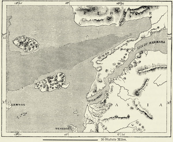
A narrow neck of land joins the peninsula of Gallipoli—the Thracian {105} Chersonesus of the ancients—to this coast range. This peninsula is composed of quaternary rocks, which differ in no respect from those met with on the shore of Asia opposite. Anciently a huge fresh-water lake covered a portion of Thracia and more than half the area now occupied by the Ægean Sea. When the land first emerged above the waters, the Chersonesus formed an integral portion of Asia. Subsequently the waters of the Black Sea, which had forced themselves a passage through the Bosphorus, likewise found their way through the Hellespont into the Ægean Sea. The geological formation of the country and the configuration of the sea-bottom prove this to have been the case, and this irruption of the waters was attended, probably, by volcanic eruptions, traces of which still exist on the islands of the Sea of Marmara and near the mouth of the Maritza, the former to the east, the latter to the west of the peninsula.
Fig. 32.—THE HELLESPONT, OR DARDANELLES, AND THE GULF OF SAROS.
Scale 1 : 1,220,000.
Μ
The dark shading expresses a depth exceeding 55 fathoms.
If the statements of Pliny and Strabo may be relied upon, the Hellespont must have been much narrower in former times than it is now. At Abydos—the modern Naghara—the width is said to have amounted to seven stadia, or less than a mile, anciently, whilst at the present time it is 6,500 feet. It was here Xerxes constructed his double bridge of boats. The strait is deep at that spot, and its current strong, but no wooden ship could hope to force a passage if covered by the guns in the batteries on both coasts. The Hellespont, like the Bosphorus, has two {106} currents flowing through it. In winter, when the rivers which flow into the Black Sea are frozen up, and the Sea of Marmara is no longer fed by the waters of the Bosphorus, a highly saline under-current penetrates from the Ægean Sea into the Dardanelles, whilst a feebler current of comparatively fresh water flows in a contrary direction on the surface.29
Gallipoli, the Constantinople of the Hellespont, stands near the western extremity of the Sea of Marmara. It is the first city which the Turks captured upon the soil of Europe; but though they settled down there nearly a hundred years earlier than they did at Constantinople, they are no more in the majority here than they are in the capital. Gallipoli, like Rodosto and other towns on the Sea of Marmara, is inhabited by Mohammedans of various races, by Greeks, Armenians, and Jews, forming separate communities dwelling within the walls of the same town. The country population consists almost exclusively of Greeks, who are the proprietors and cultivators of the land; and in sight of the coasts of Asia, and within that portion of the Balkan peninsula which has been longest under the rule of the Turk, the Greek is stronger numerically than anywhere else to the north of Mount Pindus. He does not there confine himself to the coast, and, if we except a few Bulgarian villages and the larger towns, the whole of Eastern Thracia belongs to him.
The lowlands of this region form a vast triangular plain, bounded by the Tekir Dagh and the coast range on the south, by offshoots from the Rhodope on the west, and by the granitic mountains of Stranja on the east. This is one of the dreariest districts of all Turkey. Swampy depressions and untilled land recall the steppes of Russia; and in summer, when the wind raises clouds of dust, we can imagine ourselves in the midst of a desert. The dreary monotony of this plain is relieved only by the pale contours of distant mountains, and by innumerable artificial mounds of unknown origin. So numerous are these tumuli that they form an essential feature of the landscape, and no artist could convey a just idea of it without introducing into his picture one or more of them.
Near the northern extremity of this unattractive plain, at the confluence of Maritza and Tunja, lies the city of Adrianople, enveloped in trees, whose sight delights the eye of the weary traveller. Adrianople, in reality, consists of a number of villages, separated from each other by orchards, poplars, and cypresses, above which peep out the minarets of some hundred and fifty mosques. The sparkling waters of the Maritza and Tunja, of rivulets and of aqueducts, lend animation to the picture, and render Adrianople one of the most delightful places. But it is more than this. It is the great centre of population in the interior of Turkey, and its favourable geographical position has always secured to the city a certain amount of importance. The ancient city of Orestis, the capital of the Kings of Thracia, stood on this site, and was succeeded by the Hadrianopolis of the Romans, which the Turks changed into Edirneh, and made their capital until Constantinople fell into their power. The old palace of the Sultan, built in the {107} Persian style towards the close of the fourteenth century, still remains, though in a dilapidated condition. But here, likewise, the Osmanli are in the minority. The Greeks are their equals in numbers, and far surpass them in intelligence, whilst the Bulgarians, too, muster strongly, and, as in other towns of the East, we meet with a strange mixture of races, from Persian merchants down to gipsy musicians. The Jews are proportionately more numerous in Adrianople than in any other town of Turkey, and, strange to relate, they differ from their co-religionists in every other part of the world by a lack of smartness in business transactions. A local proverb says that “it requires ten Jews to hold their own against one Greek;” and not Greeks alone, for Wallachians, and even Bulgarians, are able to impose upon the poor Israelite at Adrianople.
The communications between Adrianople and Midea, the ancient Greek colony, famous for its subterranean temples, and with other cities on the Black Sea, are difficult. Its natural outlets are towards the south—on the one hand to Rodosto, on the Sea of Marmara; on the other, down the Maritza valley to the Gulf of Saros. The railway follows the latter, and the Rumelian Railway Company has constructed an artificial harbour at Dede Aghach, enabling merchantmen to lie alongside a pier. The allurements of commerce, however, have not hitherto induced the inhabitants of Enos to exchange their walled and turreted acropolis for the marshy tract on the Lower Maritza, with its deadly atmosphere.
The zone occupied by the Greeks grows narrower as we go west of the Maritza, where the Rhodope Mountains form a kind of international barrier. Only the coast is occupied there by Greek mariners and fishermen, whilst the hills in sight of it are held almost exclusively by Turkish and Bulgarian peasants and herdsmen. The marshy littoral districts, the small valleys on the southern slopes of the mountains, and a few isolated hills of volcanic or crystalline formation constitute a narrow band which connects the Greeks of Thracia with their compatriots of Chalcidice and Thessaly. The Yuruks, or “Wanderers,” a Turkish tribe which has retained its nomadic habits down to the present day, sometimes even extend their excursions to the sea-coast. Their principal seat is in the Pilav Tepe, a mountain mass to the north-west of Thasos, famous in the time of the Macedonian kings for its mines of gold and silver. A wide plain extends immediately to the west of these mountains, watered by the Strymon, or Karasu, and is of marvellous fertility. Seres, a considerable city, occupies its centre, and hundreds of villages, surrounded by orchards, rice, and cotton fields are scattered over it. Looked at from the heights of the Rhodope, this plain assumes the appearance of a huge garden-city. Unfortunately many parts of it are very insalubrious.
The triple peninsula of Chalcidice has no connection whatever with the Rhodope, and is attached to the mainland by an isthmus covered with lakes, swamps, and alluvial plains. It extends far into the sea like a huge hand spread out upon the waters. Chalcidice is a Greece in miniature, with coasts of fantastic contours, deep bays, bold promontories, and mountains rising in the midst of plains, like islands in an archipelago. One of these mountain masses rises in the trunk of the peninsula, and culminates in Mount Kortach, whilst each of its three {108} ramifications possesses its own system of scarped hills. Greek in aspect, this curious appendage to the continent is Greek, too, in its population; and, a rare thing in Turkey, all its inhabitants are of the same race, if we except the Turks in the town of Nisvoro and the Slav monks of Mount Athos.
Μ
Fig. 33.—THE PENINSULA OF MOUNT ATHOS.
Scale 1 : 1,020,000.
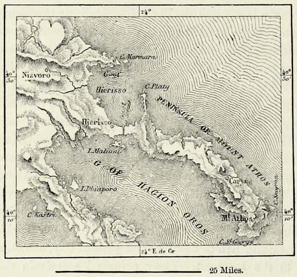
The easternmost of the three tongues of land of Chalcidice, which jut out far into the waters of the Ægean, is almost entirely detached. Only a low and narrow neck of land connects it with the mainland, and it was across this isthmus that Xerxes dug a canal, 3,950 feet in length, either to enable his fleet to avoid the dangerous promontory of Mount Athos, or to give the awe-struck inhabitants a proof of his power. This is the peninsula of Hagion Oros, the Monte Santo of the Italians. At its extremity rises a limestone mountain, one of the most beautiful in the Eastern Mediterranean. This is the famous Mount Athos, which an ancient sculptor proposed to convert into a statue of Alexander, holding a city in one hand and a spring in the other, and which Eastern legends point out as the “exceeding high mountain” to which the devil took Jesus, to show him “all the kingdoms of the world.” But whatever old legends may say, the panorama is not as vast as this, though the shores of Chalcidice, Macedonia, and Thracia lie spread out beneath our feet, and the eye can range across the blue waters of the Ægean Sea from Mount Olympus, in Thessaly, to Mount Ida, in Asia Minor. The bold outlines of the fortified monasteries which appear here and there, in the midst of chestnuts, oaks, or pines, on the slope of the mountain, contrast most happily with the faint outline of the coasts on the distant horizon.30
This peninsula, which a traveller has compared to a sphinx crouching upon the bosom of the sea, is the property of a republic of monks, who govern {109} themselves according to their own fancy. In return for a tribute, which they pay to the Porte, they alone have the right to live there, and strangers require their permission before they are allowed to enter. A company of Christian soldiers is stationed at the neck of the peninsula to prevent the sacred soil being desecrated by the footsteps of a woman. Even the Turkish governor cannot gain admittance without leaving his harem behind him. For fourteen hundred years, we are told in the chronicles of Mount Athos, no female has set foot upon this sacred soil, and this prohibition extends to animals as well as to human beings. Even the presence of poultry would profane the monasteries, and the eggs eaten by the monks are imported from Lemnos. With the exception of a few purveyors, who reside at the village of Karyes, the 6,000 inhabitants of the peninsula are monks, or their servants, and they live in the monasteries, or in the hermitages attached to the 935 churches and chapels. Nearly all the monks are Greeks, but amongst the twenty large monasteries there are two which were built by the ancient sovereigns of Servia, and one which was founded by Russia. Most of these edifices occupy promontories, and, with their high walls and strong towers, they are exceedingly picturesque. One amongst them, that of Simopetra, appears to be almost inaccessible. It is in these retreats the good fathers of the order of St. Basil spend their lives in contemplative inaction. They are bound to pray eight hours in the day and two in the night, and during the whole of that time they are not allowed to sit. They have, therefore, neither time nor strength for study or manual labour. The books in their libraries are incomprehensible mysteries to them, and, in spite of their sobriety, they might die of starvation if there were not lay-brothers to work for them, and numerous farms on the mainland which are their property. A few shiploads of hazel nuts is all this fertile peninsula produces.
The ancient cities of Olynthus and Potidæa, on the neck of the western peninsula of Chalcidice, have dwindled down into insignificant villages; but the city of Therma, called afterwards Thessalonica, and now known as Saloniki, still exists, for its geographical position is most favourable, and after every siege and every conflagration it again rose from its ashes. Vestiges of every epoch of history may still be seen there: Cyclopean and Hellenic walls, triumphal arches, and remains of Roman temples, Byzantine structures, and Venetian castles. Its harbour is excellent, its roadstead well sheltered; and the high-roads into Upper Macedonia and Epirus lead from it along the valleys of the Vardar and Inje Karasu. These favourable circumstances have not been without their influence, and Saloniki, next to Constantinople and Adrianople, is the most important city of European Turkey. Its population is mixed, like that of other cities in the East, and Jews are exceptionally numerous. Most of them are the descendants of Spanish Jews, expelled by the Inquisition, and they still talk Spanish. Many have outwardly embraced Mohammedanism to escape persecution, but the true Mussulman spurns these converts with disdain. They are generally known as “Mamins.”
The commerce of Saloniki is important even now, but greater things are {110} expected of the future. Like Marseilles, Trieste, and Brindisi, Saloniki aspires to become a connecting link in the trade between England and the East. It actually lies on the most direct road between the Channel and the Suez Canal, and once connected by railways with the rest of Europe, it is sure to take a large share in the world’s commerce. This emporium of Macedonia is interesting, too, from an ethnological point of view, for, with the exception of Burgaz, on the Black Sea, it is the only place where the Bulgarians, the most numerous race of European Turkey, have reached the sea-coast. Everywhere else they are cut off from it by alien races, but Saloniki brings them into direct contact with the remainder of Europe. Saloniki, however, not only suffers from bad government, but also from the marshes which surround it, and in summer many of its inhabitants flock to the healthier town of Kalameria, to the west. Miasmatic swamps unfortunately occupy a large portion of the northern coast of the Ægean, and they separate the interior of Macedonia more effectively from the coast than do its mountains. There is hardly any commerce except at Saloniki.
Fig. 34.—MOUNT OLYMPUS.
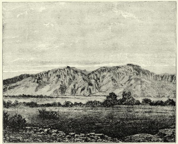
On the western shores of the Gulf of Saloniki, beyond the ever-changing mouths of the Vardar and the briny waters of the Inje Karasu, or Haliacmon, the land gradually rises. Hills are succeeded by mountains, until bold precipices {111} approach close to the coast, and summit rises beyond summit, up to the triple peak of Mount Olympus. Amongst the many mountains which have borne this name, this is the highest and the most beautiful, and the Greeks placed upon it the court of Jupiter and the residence of the gods. It was in the plains of Thessaly, in the shadow of this famous mountain, that the Greeks lived in the springtide of their history, and their most cherished traditions attach themselves to this beautiful country. The mountains which had sheltered the cradle of their race remained to them for ever afterwards the seat of their protecting deities. But Jupiter, Bacchus, and the other great gods of antiquity have disappeared now, and monasteries have been built in the woods which witnessed the revels of the Bacchantes.
Μ
Fig. 35.—MOUNT OLYMPUS AND THE VALLEY OF TEMPE.
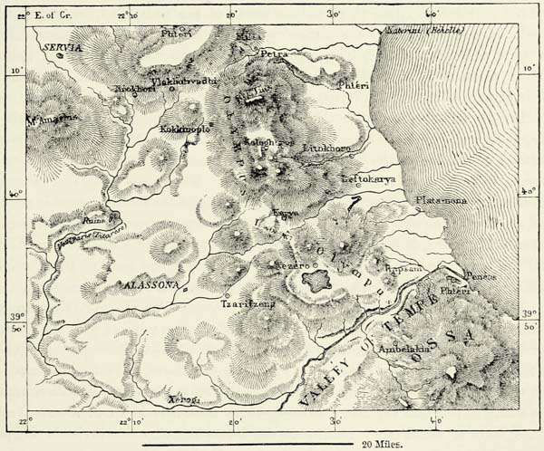
Until recently the upper valleys of Mount Olympus were inhabited only by monks, and by klephtes, or bandits, who sought shelter there from the Arnaut soldiers sent in their pursuit. The mountain, in fact, constitutes a world apart, surrounded on all sides by formidable declivities. Forty-two peaks form the battlements of this mountain citadel, fifty-two springs rise within it, and the bold klepht is secure within its fastnesses from the abhorred Turk. Magnificent forests of laurel-trees, planes, and oaks cover its lower maritime slopes, and in times of trouble they have served as a refuge to entire populations. But Italian {112} speculators have purchased these forests, and the time is not, perhaps, very distant when Mount Olympus, deprived of its verdure, will be reduced to a barren mass of rock, like most of the mountains of the Archipelago. Wild cats abound on the lower slopes of Olympus, chamois still climb its rugged pinnacles, but bears are no longer met with: St. Denys, who dwelt upon the mountain, required beasts to ride upon, and changed them into horses !
Xenagoras, an ancient geometrician, was the first to measure the height of Mount Olympus, but his result, 6,200 feet, is far from the truth, for the highest summit attains an elevation of 9,750 feet.31 It may possibly be the culminating point of the Balkan peninsula. Snow remains in some of its crevices throughout the year, and no human being hitherto appears to have succeeded in ascending its highest pinnacle. According to the Greek legend, even Pelion heaped upon Ossa did not enable the Titans to reach the abode of the gods, and, in reality, the combined height of these two mountains hardly exceeds that of Olympus. But, in spite of this inferior height, “pointed” Ossa and “long-stretched” Pelion, known to us moderns as Kisovo and Zagora, impress the beholder, because of their savage valleys, their precipitous walls of rock, and cliffy promontories.
These mountains continue southward through the hook-shaped peninsula of Magnesia, and terminate opposite the island of Eubœa. They formed a strong bulwark of defence in the time of ancient Greece. The hordes of the barbarians stopped in front of this insurmountable barrier. They were compelled to seek a practicable road to the west of it, through the valley of the Peneus, which is rightly looked upon as the natural frontier of Hellas. Hence the great strategical importance of Pharsalus, in Southern Thessaly, which protects the gorges of the Othrys and the only access to the plains of the Sperchius. The pass of Petra, at the northern extremity of Olympus, was carefully guarded for similar reasons.
A large portion of the area bounded by the crystalline rocks of Olympus and Ossa, and by the cretaceous range of the Pindus, running parallel with the former, consists of plains originally covered by vast lakes. The Gulf of Volo approaches close to the shrunken remains of one of these lakes—that of Karla, or Bœbeis—into which the waters of the swampy plain of Larissa discharge themselves. The dwellers on the shores of this lake say that a dull rumbling noise may now and then be heard at its bottom, which they ascribe to the bellowing of some invisible animal, but which is more probably the gurgling sound of the water penetrating into a sink-hole. Other lake basins are met with at the foot of Olympus towards the west and north-west, and some of the valleys of the upper tributaries of the Peneus are covered with alluvium left behind by the receding waters. Hercules, according to some—Neptune, according to others—drained all these lakes of Thessaly into the Ægean, by opening the narrow gorge between Olympus and Ossa, known to the ancients as the Valley of Tempe. This narrow valley is due, no doubt, to the slow erosive action of water. To the Hellenes it realised their ideals of refreshing coolness and beauty, and once every nine years an embassy arrived from Delphi to pluck the laurel-leaves destined for the victors in the Pythian games. The {113} Valley of Tempe is indeed most beautiful; the transparent and rapid waters of the Peneus, the foliage of the planes, the shrubberies of laurel-roses, and the red-hued cliffs—these combine frequently, and form pictures which delight the senses and impress the mind. But, taken as a whole, this narrow and sombre valley fairly deserves its modern name of Lykostomo, or “wolf’s gorge.” Even in Thessaly, and, above all, in the Pindus, there are localities more smiling and more beautiful than this famous Valley of Tempe.
The upper valleys of the Peneus, or Salembria, abound in natural curiosities, such as defiles, sinks, and caverns. To the north-west of Mount Olympus, the turbid Titaresius flows through the narrow gorge of Saranta Poros, or of the Four Fords, which was looked upon in former times as one of the gates of hell.
To the west, on the Upper Peneus, are the limestone hills of Khassia, rising to a height of 5,000 feet, and the elevated spurs of Mount Pindus, which have become celebrated through the “works of the gods,” or theoktista, which surmount them. These “works” consist of isolated towers, crags, and pillars, the most famous amongst them being those on the banks of the Peneus, not far from Trikala. Zealous followers of Simeon the Stylite conceived the idea of building their monasteries on the tops of some of the larger of these natural columns or pedestals. Perched on these heights, and condemned never to leave them, they receive their provisions and visitors in a basket attached to the end of a long rope, and hoisted aloft by means of a windlass. An aërial voyage of no less than 220 feet has to be performed in order to reach in this manner the monastery of Barlaam, and visitors are at liberty to effect this ascent by means of ladders fastened against the rocky precipices. The religious zeal, however, which led monks to select these eyries for their habitations is gradually dying out. Out of twenty monasteries which existed formerly, there remain now but seven, and only one of these, that of Meteora, is inhabited by as many as twenty monks.
Of all the Greek countries which still remain under the dominion of the Turks, there is none which has so frequently sought to regain its independence, none which is claimed by the Hellenes with equal ardour as a portion of their common fatherland and the cradle of their race. Thessaly is, in truth, a portion of Greece, as far as the traditions of the past, a common language, and the general aspects of the country can make it so. But it is a more fertile country, its vegetation is more luxuriant, its landscapes are more smiling and delightful. We may not frequently meet with the deep blue sky which calls forth our admiration in Southern Greece, for the vapours rising from the Ægean Sea are attracted by Olympus and other mountains; but this moisture imparts a charm to distant views, and, by protecting the earth against the scorching rays of the sun in summer, it contributes largely towards the fertility of the soil.
The Greek population of Thessaly is strongly mixed with foreign elements, which it has gradually assimilated. Neither Serbs nor Bulgarians remain now in the country, although the Upper Titaresius is known as Vurgari, or “river of the Bulgarians.” The Zinzares, or Macedo-Walakhs, who were so numerous in the Middle Ages, now only occupy a few villages. Though proud of their Roman {114} descent, they gradually become Hellenized. Most of the words by which they designate objects of civilised life are Greek, their priests and schoolmasters preach or teach in Greek, and they themselves speak Greek in addition to their native language. They lose ground, moreover, through an excessive emigration. Even the cultivators of the soil amongst them have not quite given up their nomadic habits, and the roving life of a herdsman or of a pedlar exercises an irresistible attraction upon them. The Turks inhabit in compact masses the lowlands around Larissa, and that town itself is Mussulman to a large extent. The hilly tracts to the north, between the Inje Karasu and the Lakes of Kastoria and Ostrovo, are likewise inhabited by Turks, who differ from the Osmanli of the rest of the empire, and are known as Koniarides. Turks also occupy a portion of Mount Ossa. It is easy to tell from a distance whether a village is inhabited by Turks or by Greeks. M. Mézières has observed that “the Turks plant trees for the sake of shade, the Greeks for the sake of profit.” Near the villages of the former we find cypresses and plane-trees, near those of the latter orchards and vineyards. The Koniarides are believed by some authors to have come to Thessaly and Macedonia as colonists in the eleventh century, by invitation of the Eastern emperor. They govern themselves through democratic representative bodies, and are respected by all, because of their probity, their hospitality, and their rustic virtues.
The Greeks are morally inferior to the Turkish peasantry, but they surpass them in intelligence and industry. In the seventeenth century there took place amongst them even a sort of revival similar to the Renaissance of Western Europe, and the love of art was developed sufficiently far to give rise to a school of painters in the villages of Olympus. Faithful to their national traditions and the instincts of their race, the Greeks of Thessaly have sought to organize themselves into self-governing commonwealths. In their free towns, or kephalokhori, they are permitted to elect their town councils, establish schools, and appoint what teachers they like. They know how to get the Turkish pasha not to meddle in their local affairs. They pay the taxes demanded by the Turks, as their ancestors paid them to Athens or some other Greek city, but in every other respect they are free citizens governing themselves. The contrast between these independent commonwealths and the chifliks of Mussulman proprietors cultivated by Greek farmers is most striking. The land of the free proprietors is, as a rule, far less fertile than that included within these chifliks; yet it produces more, and its cultivators live in comparative ease.
The Greeks of Thessaly bestow much care upon the education of growing generations. Even the most miserable Greek village in the Pindus can boast of a school, which is visited by the young people up to the age of fifteen. As an instance of the commercial spirit of the Thessalians we may mention the Weavers’ Co-operative Association, formed in the last century in the town of Ambelakia, delightfully situated amongst orchards and vineyards on the southern slopes of the Valley of Tempe. This powerful association wisely limited its dividends to six per cent., and expended the surplus profits upon an extension of its business. For {115} many years it enjoyed the greatest prosperity, but the wars of the empire, which closed the markets of Germany against it, brought about its ruin. Co-operation likewise partly accounts for the flourishing cloth manufacture of the twenty-four wealthy Greek villages on the peninsula of Magnesia, to the north of the Gulf of Volo. This district, together with that of Verria, to the north of the Inje Karasu, is probably the most prosperous in all the Greek provinces of Turkey, and it is at least partly indebted for this prosperity to its happy geographical position, being far away from great strategical high-roads.32
IV.—ALBANIA AND EPIRUS.
The name of SHKIPERI, which the Albanians give to the country they inhabit, is supposed to mean “land of rocks,” and no designation could be more appropriate. Stony mountains occupy the whole of the country, from the frontiers of Montenegro to those of Greece. The only plain of any extent is that of Scutari (Shkodra), to the south of the Montenegrin plateau, which forms the natural frontier of Albania towards the north. The bottom of this depression is occupied by the Lake of Scutari; and the Drin, the only river of the Balkan peninsula which is navigable for a considerable distance from the sea, debouches upon it. The Drin is formed by the junction of the White and the Black Drin, and in former times it only discharged a portion of its waters temporarily into the Boyana River, which drains the Lake of Scutari. But in 1858 it opened itself a new channel opposite to the village of Miet, about twenty miles above its mouth, and since that time the greater volume of its waters flows in the direction of Scutari, frequently inundating the lower quarters of that town. The marshy tracts on the Lower Drin are dangerous to cross during the heat of summer, and the fevers of the Boyana are the most dreaded along the whole of that coast.
Most of the southern ramifications of the Bosnian Alps are inhabited by Albanians, but they are separated from their kinsmen in Albania proper by the deep valley of the Drin, a kind of cañon similar to those of the Rocky Mountains, enclosed between precipitous walls several thousand feet in height, and hardly ever trodden by the foot of a wanderer. The mountain systems of Bosnia and Albania are only indirectly connected by a series of ranges and plateaux stretching from the mountain of Glieb in a south-easterly direction as far as the Skhar, or Scardus of the ancients. The crest of this latter runs at right angles to most of the ranges of Western Turkey, and although its culminating point is inferior in height to those of Slav Turkey, it is the point of junction between the Balkan and the {116} mountain systems of Bosnia and Albania. The Skhar is of great importance, too, in the hydrography of Turkey; for two great rivers, the Bulgarian Morava and the Vardar, descend from its flanks, one flowing to the Danube, the other to the Gulf of Saloniki. Chamois and wild goats are still met with in the Skhar, as in the Pindus and Rhodope, and M. Wiet mentions an animal known to the Mirdits as a lucerbal, which appears to be a species of leopard.
A mountain region, hardly 3,000 feet in elevation, but exceedingly difficult of access, rises to the west of the Skhar, on the other side of the Black Drin: this is the citadel of Upper Albania, the country of the Mirdits and Dukajins. Enormous masses of serpentine have erupted there through the chalk, the valleys are hemmed in by bold precipices, and the torrents rapidly run down the hollowed-out beds on the exterior slopes. As a rule, the direction of the tortuous ranges of this mountain country is the same as that of the southern spurs of the Skhar. They gradually decrease in height, enclosing fine upland valleys, where the waters are able to accumulate. The Lake of Okhrida, the largest sheet of water in Upper Albania, has not inaptly been likened to the Lake of Geneva. Its waters are bluer even than those of its Swiss rival, and more transparent, and fish may be seen chasing each other at a depth of sixty feet beneath its surface: hence its ancient Greek name of Lychnidos. The delightful little town of Okhrida and Mount Pieria, with its old Roman castle, guard its shores, and the white houses of numerous villages peep out amongst the chestnut forests which cover the slopes of the surrounding hills. This lake is drained towards the north through the narrow valley of the Black Drin. If the statements of the inhabitants may be credited, the waters of the double basin of Lake Presba reach Lake Okhrida through subterranean channels.
The isolated peak of Tomor commands this lake region on the west. To the south of it commences the chain of the Pindus, locally known as Grammos. At first of moderate height, and crossed by numerous mountain roads affording easy communication between Albania and Macedonia, these mountains gradually increase in height as we proceed south, and exactly to the east of Yanina they form the mountain mass of Metzovo, with which the Pindus, properly so called, takes its rise. This mountain mass is inferior in altitude to the peaks of Bosnia or Northern Albania, but it is far more picturesque than either, its slopes being covered with forests of conifers and beech-trees, and the plains extending along its foot having a more southern aspect. Mount Zygos, or Lachmon, which rises in the centre of this mountain mass, does not afford a very extended panorama, but if we climb the craggy peaks of the Peristera-Vuna, or Smolika, near it, we are able to look at the same time upon the waters of the Ægean and Ionian Seas, and even the shore of Greece may be descried beyond the Gulf of Arta.
A famous lake occupies the bottom of the limestone basin at the western foot of the mountain mass of Metzovo. This is the Lake of Yanina, and nowhere else throughout Epirus do we meet with an equal number of natural curiosities as on the shores of this lake. Its depth is inconsiderable, nowhere exceeding forty feet, and it is fed only by numerous springs rising at the foot of the rocks. There is no {117} visible outlet; but Colonel Leake assures us that each of the two basins into which it is divided is drained by a subterranean channel. The northern lake pours its waters into a sink, or voinikova, and reappears towards the south-west as a considerable river, which flows into the Ionian Sea. This is the Thyamis of the ancients, our modern Kalamas. Farther to the south the ancient Acheron bursts from the rocks, and having received the nauseous waters of the equally famous Cocytus, throws itself into the “bay of sweet waters,” thus called on account of the large volume of water discharged into it by rivers.
Μ
Fig. 36.—SOUTHERN EPIRUS.
According to Kiepert. Scale 1 : 1,400,000.
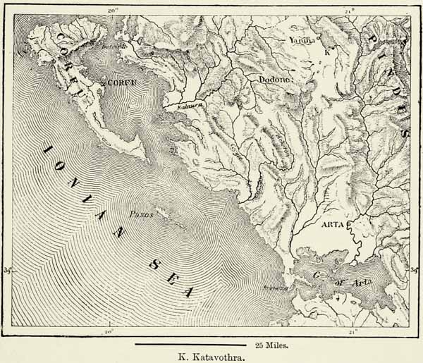
When the waters of the southern and larger basin of Lake Yanina are low, there is but a single effluent, which plunges down into an abyss, and in doing so turns the wheels of a mill. The Cyclopean ruins of the Pelasgic city of Hellas command this huge chasm with its roaring waters. The subterranean river reappears far to the south, and flows into the Gulf of Arta. But when the level of the lake is high, four other sinks swallow up its superabundant waters, and convey them into the main channel, the direction of which is indicated by a few small lakes. The important part played in the mythology of ancient Greece by these subterranean effluents, and particularly by the infernal Acheron and the Cocytus, amply proves the influence exercised by the Pelasgians upon the civilisation of the Hellenes. The myths of the Hellopians became the common property of all Greece, and {118} there was no temple in all Hellas more venerated than their sanctuary at Dodona, where the future might be foretold by listening to the rustling of the leaves of sacred oaks. This sacred grove existed, probably, near one of the Cyclopean towns so numerous in the country, if not on the shore of the lake itself. Some, erroneously no doubt, have looked for it near the castle inhabited in the beginning of this century by Ali Tepeleni, the terrible Pasha of Epirus, who boasted of being a “lighted torch, devouring man.”
The mountains of Suli, to the west of the basin of Yanina, attain an altitude of 3,500 feet, but the neighbouring hills are of moderate height, though abrupt and difficult of access, and near the coast they sink down into small rocky promontories, scantily clothed with shrubs and overrun by jackals. Swamps abound near the shore, and during summer their miasmatic air spreads over the neighbouring villages. To the north of the swamps of Butrinto and of the channel of Corfu, and to the west of the isolated peak of Kundusi, however, the coast rises again, and the austere chain of the Chimæra Mala, or Acroceraunii, extends along it. It was dreaded by the ancients on account of its tempests, and the torrents which poured down its sides. Squalls and changes of wind are frequent near the “Tongue (Linguetta) of Rocks,” the most advanced promontory of this coast, at the entrance to the Adriatic Sea. These are the “infamous rocks” referred to by the Roman poet, upon which many a vessel suffered shipwreck. The channel which separates Turkey at that place from Italy has a width of only 45 miles; it is less than 100 fathoms in depth, and at some former period an isthmus may have united the two countries.33
The Shkipetars, or Albanians, are subdivided into two leading tribes or nations, the Tosks and the Gheges, both of whom are no doubt descended from the ancient Pelasgians, but have in many places become mixed with Slavs, Bulgarians, and Rumanians, and perhaps even with other nations; for whilst in some tribes we meet with the purest Hellenic types, there are others the members of which are repulsively ugly. The Gheges are the purest of their race, and they occupy, under various tribal names, the whole of Northern Albania as far as the river Shkumbi. The territory of the Tosks extends from that river southward. The dialects of these two nations differ much, and it is not easy for an Acroceraunian to understand a Mirdit or other Albanian from the north. Gheges and Tosks detest each other. In the Turkish army they are kept separated for fear of their coming to blows, and, when an insurrection has to be suppressed amongst them, the Turkish Government always avails itself of these tribal jealousies, and is certain of being served with the zeal and fury which hatred inspires.
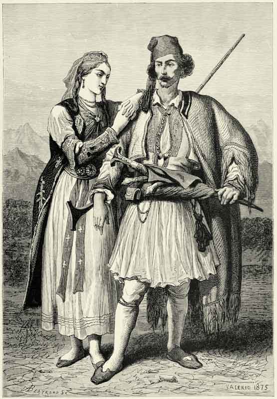
ALBANIANS.
Up to the period of the migration of the barbarians, the whole of Western Turkey, as far as the Danube, was held by Albanians. But they were then pushed back, and Albania was entirely occupied by Servians and Bulgarians. {119} The names of numerous localities throughout the country recall that period of obscuration, during which the name of an indigenous race was not even mentioned by the historian. But when the Osmanli had broken the power of the Serb, the Albanians again raised their heads, and ever since they have kept encroaching upon their Slav neighbours. In the north they have gradually descended into the valley of the Bulgarian Morava, and one of their colonies has even penetrated into independent Servia. Like the waters of a rising ocean, they overwhelm the detached tracts of territory still occupied by Servians. This progress of the Albanians is explained, to a great extent, by the voluntary expatriation of the Servians. Thousands of them, headed by their patriarchs, fled to Hungary, in order to escape the dominion of the Turks, and the Albanians occupied the wastes they left behind. The Servians still hold their ground near Acroceraunia, on the shores of Lake Okhrida, and in the hills looking down upon the fatal plain of Kosovo, where their ancestors were massacred; but they gradually become Albanians in language, religion, and customs. They speak of themselves as Turks, as do the Arnauts, and apply the name of Servian only to the Christians dwelling beyond the frontier. On the other hand, many of the customs of the Gheges agree in a remarkable manner with those of their Slav neighbours, and this proves that there has taken place a thorough blending of the two races.
But whilst the Albanians are gaining ground in the north, they are losing it in the south. A large portion of the inhabitants of Southern Albania, though undoubtedly of Pelasgic origin, are Greek by language. Arta, Yanina, and Prevesa are Hellenized towns, and only a few Mohammedan families there still speak Albanian. Nearly the whole of the tract between the Pindus and the Adriatic coast ranges has become Greek as far as language goes, and throughout the mountain region extending westward to the sea the inhabitants are “bilingual;” that is to say, they speak two languages. The famous Suliotes, for instance, who talk Tosk within the bosom of their family, make use of Greek in their intercourse with strangers. Wherever the two races come into contact, it is always the Albanian who takes the trouble to learn Greek.
This influence of the Hellenes is all the more powerful as it meets with support amongst the Zinzares, known also as Macedo-Walakhs, “Limping” Walakhs, or Southern Rumanians, who are met with throughout the country. These Zinzares are the kinsmen of the Rumanians of Wallachia and Moldavia, and live in a compact body only on the two slopes of the Pindus, to the south and east of the Lake of Yanina. Like the Rumanians of the Danube, they are most probably Latinised Dacians. They resemble the Walakhs in features, character, and disposition, and speak a neo-Latin tongue much mixed with Greek. The Zinzares in the valleys of the Pindus are, for the most part, herdsmen, and wander away from their villages sometimes for months. Others carry on trades, exhibiting much manual skill and intelligence. Nearly all the bricklayers of Turkey, those of the large towns excepted, are Zinzares; and the same individual sometimes erects an entire house, doing in turn the work of architect, carpenter, joiner, {120} and locksmith. The Rumanians of the Pindus are likewise esteemed as clever goldsmiths.
Their capacity for business is great, and the commerce of the interior of Turkey is almost entirely in their hands, as is that of the maritime districts in those of the Greeks. The Walakhs of Metzovo are said to have stood formerly under the direct protection of the Porte, and every traveller, whether Mussulman or Christian, was bound to unshoe his horses before he left their territory, for fear “of his carrying away a clod of earth which did not belong to him.” Commercial houses conducted by Walakhs of the Pindus are met with in every town of the Orient, and even at Vienna one of the most influential banks has been founded by one of them. Abroad they are generally taken for Greeks, and the wealthier amongst them send their children to Athens to be educated. Surrounded by Mussulmans, the Zinzares of the Pindus feel the necessity of attaching themselves to some country through which they might obtain their freedom, and they hope for a union with Greece. It is only quite recently that they have learnt to look upon the Rumanians of the North and the Italians as their kinsmen. They do not, however, set much store upon their nationality, and have no aspirations as a distinct race. There can be no doubt that in the course of ages many of these Macedo-Walakhs have become Hellenized. Nearly all Thessaly was inhabited by Zinzares in the Middle Ages, and Byzantine authors speak of that country as “Great Wallachia.” Whether these Zinzares have emigrated to Rumania, as some think, or have become assimilated with the Greeks, the fact remains that at the present day they are not very numerous on the eastern slopes of the Pindus. Thousands of Rumanian families have settled in the coast towns, at Avlona, Berat, and Tirana, embracing Mohammedanism, but still retaining their native idiom.
If we exclude these Zinzares, the Greeks of Epirus, the Servians, and the few Osmanli dwelling in the large towns, there remain only the semi-barbarous Gheges and Tosks, whose social condition has hardly undergone any change in the course of three thousand years. In their manners and modes of thought these modern Albanians are the true successors of the ancient Pelasgians, and many a scene that a traveller may witness amongst them carries him back to the days of the Odyssey. G. von Hahn, who has most thoroughly studied the Shkipetars, looks upon them as veritable Dorians, whose ancestors, led by the Heraclidæ, burst forth from the forests of Epirus to conquer the Peloponnesus. They are as courageous, as warlike, as fond of dominion, and as clannish as were their ancestors. Their dress, likewise, is nearly the same, and the white tunic (fustanelle) neatly fastened round the waist fairly represents the ancient chlamys. The Gheges, like the Dorians of old, are addicted to that mysterious passion which the historians of antiquity have confounded, unfortunately, with a nameless vice, and which links men to children by a pure and ideal love, in which the senses have no part.
There is no modern people respecting whom more astounding acts of bravery are recorded than of the Albanians. In the fifteenth century they had their Scanderbeg, who, though the theatre of his glory was more circumscribed than that of his namesake of Macedonia, was hardly inferior to him in genius, and {121} certainly surpassed him in justness and goodness of heart. Or what nation has ever exceeded in courage the Suliote mountaineers, amongst whom not an aged man, a woman, or a child was found to beg for mercy from Ali Pasha’s executioners? The heroism of these Suliote women, who set fire to the ammunition waggons, and then hand in hand precipitated themselves from the rocks, or sought death in the mountain torrents, chanting their own funeral song, will at all times stand forth in history as an astounding fact.
This valour, unfortunately, is associated amongst many tribes with a fearful amount of savageness. Human life is held cheap amongst these warlike populations; blood calls for blood, and victim for victim. They believe in vampires and phantoms, and occasionally an old man has been burnt alive, on suspicion of his being able to kill by the breath of his mouth. Slavery does not exist, but woman is held in a state of servitude; she is looked upon as an inferior being, having no rights or mind of her own. Custom raises a more formidable barrier between the sexes than do walls and locked doors elsewhere. A young girl is not permitted to speak to a young man; such an act is looked upon as a crime, which her father or brother may feel called upon to punish by a deed of blood. The parents sometimes consult the wishes of their son when about to marry him, but never those of their daughter. The latter is frequently affianced in her cradle, and, when twelve years of age, she is handed over to a young man on his presenting a wedding outfit and a sum of money fixed by custom, and averaging twenty shillings. From that moment he becomes the absolute master of his bride, though not without first going through the farce of an abduction, as is customary amongst nearly all ancient nations. The poor woman, thus sold like a slave, is bound to work for her husband. She is his housekeeper as well as his labourer, and the national poets compare her to the “ever-active shuttle,” whilst the father of the family is likened to the “majestic ram marching at the head of the flock.” Yet woman, scorned though she be, and brutalised by heavy work, may traverse the whole country without fear of being insulted, and the life of an unfortunate who places himself under her protection is held sacred.