ITALY.*
Reading edition
ITALY.*

I.—GENERAL ASPECTS.
HE limits of the Italian peninsula have been most distinctly traced by nature. The Alps, which bound it in the north, from the promontories of Liguria to the mountainous peninsula of Istria, present themselves like a huge wall, the only breaches in which are formed by passes situated high up in the zones of pines, pastures, or eternal snows. Italy, like its two sister peninsulas of Southern Europe, thus constitutes a world of its own, destined by nature to become the theatre of a special evolution of humanity. Its delightful climate, beauteous skies, and fertile fields distinguish it in a marked manner from the countries lying beyond the Alps; and an inhabitant of the latter who descends the sunny southern slope of this dividing range cannot fail to perceive that everything around him has changed, and that he has entered a “new world.”

The protecting barrier of the Alps and the sea which bounds it have imparted to Italy a distinct individuality. All its countries, from the plains of Lombardy to the shores of Sicily, resemble each other in certain respects. There is a sort of family likeness about them; but still what delightful contrasts, what {184} picturesque variety, do we not meet with ! Most of these contrasts are due to the Apennines, which branch off from the southern extremity of the French Alps. At first they run close to the seashore, like a huge wall supported at intervals by powerful buttresses; subsequently they traverse the whole of the peninsula. At times they are reduced to a narrow ridge, at others they spread out into vast masses, rising in plateaux or ramifying into chains and promontories. River valleys and plains intersect them in all directions; lakes and filled-up lake basins are spread out at the foot of their cliffs; and numerous volcanoes, rising above the general level, contrast, by their regular form, with the rugged declivities of the Apennines. The sea, following these sinuosities in the relief of the ground, forms a series of bays, arranged with a certain degree of symmetry. In the north these bays do not much encroach upon the land, but in the south they penetrate deeply, and almost form veritable gulfs. There once existed an Italy of granitic rocks, but it exists no longer, for the rocks of the Apennines and of the plains teach us that the Italy of the present is of recent origin, and that the many islands of which it consisted formerly were united into a single peninsula as recently as the Eocene epoch.
Italy, compared with Greece, exhibits much sobriety in its configuration. Its mountains are arranged in more regular ridges, its coasts are less indented, its small archipelagos bear no comparison with the Cyclades, and its three great dependent islands, Sicily, Sardinia, and Corsica, are regular in their contours. Indeed, its contours mark its intermediate position between joyous Greece and severe Iberia. Thus there exists a correspondence between geographical position and contours.
Italy, as a whole, contrasts in a remarkable manner with the Balkan peninsula. The former faces the Ægean, and looks towards the east, whilst in the truly peninsular portion of Italy, to the south of the plains of Lombardy, the westerly slopes offer most life. Secure harbours are most numerous on the shores of the Tyrrhenian, and the largest and most fertile plains slope down towards that sea. It results from this that the western slopes of the Apennines have given birth to the most enterprising and intelligent populations, who have taken the lead in the political history of their country. The west represents the light, whilst the east, bounded as it is by the Adriatic, an inland sea almost, a simple gulf, represents the night. True, the plains of Apulia, though on the east, are wealthier and more populous than the mountain regions of Calabria, but the vicinity of Sicily, nevertheless, even there insures the preponderance of the western littoral. Whilst Greece was in the height of her glory, whilst every initiative went forth from Athens, the cities of Asia Minor, and the islands of the Ægean, those republics which looked towards the east, such as Tarentum, Locri, Sybaris, Syracuse, and Catania, enjoyed a pre-eminence over the cities on the western littoral. The physical configuration of Italy thus facilitated the march of civilisation from the south-east to the north-west, from Ionia to Gaul. The Gulf of Taranto and the eastern coasts of Greater Greece and Sicily were freely exposed to Hellenic influences, whilst further north the peninsula faces about to {185} the west as it were. There can be no doubt that these features greatly facilitated the expansion of ideas in the direction of Western Europe, and that if it had been otherwise civilisation would have taken another direction.
For nearly two thousand years, from the fall of Carthage to the discovery of America, Italy remained the centre of the civilised world. It maintained its hegemony either by conquest and organization, as in the case of the “Eternal City,” or by the power of its genius, the relative liberty of its institutions, its sciences, arts, and commerce, as in the times of Florence, Genoa, and Venice. Two of the greatest events in history, the political unification of the Mediterranean world under the laws of Rome, and at a later epoch the regeneration of the human mind, so appropriately termed “Renaissance,” originated in Italy. It behoves us, therefore, to inquire into the geographical conditions which may account for this preponderance during these two ages in the life of mankind.
Mommsen and others have pointed out the favourable position of Rome as an emporium. From the very first that city became the commercial centre of the neighbouring populations. Built in the centre of a circus of hills, and on the banks of a navigable river, not far from the sea, it likewise possessed the advantage of lying on the frontiers of three nations—Latins, Sabines, and Etruscans. When Rome had conquered the neighbouring territories it undoubtedly rose into importance as a place of commerce. This local traffic, however, would never have converted Rome into a great city. Its position is not to be compared with that of places like Alexandria, Constantinople, or Bombay, upon which the world’s commerce converges as a matter of course. On the contrary, its situation hardly favours commerce. The Apennines, which environ the territory of Rome in a huge semicircle, constituted a formidable obstacle until quite recently, and were avoided by merchants; the sea near Rome is treacherous, and even the small galleys of the ancients could not enter the inefficient harbour at Ostia without risk.
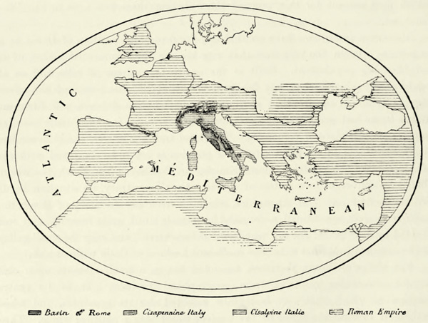
The power of Rome, therefore, depended but in a small measure upon commercial advantages resulting from geographical position. It is its central position to which that city is mainly indebted for its greatness, and which enabled it to weld the whole of the ancient world into a political whole. Three concentric circles drawn around the city correspond with as many phases in its development. During their first struggles for existence the Romans enjoyed the advantage of occupying a basin of limited extent, shielded on all sides by mountains. When Rome had exterminated the inhabitants of these mountains the remainder of Italy naturally gravitated towards her. The plains of Cis-and Transpadana in the north presented no obstacles, whilst the resistance of the uncivilised tribes of the mountain regions of the south was soon broken, for they found no support amongst the Greek colonies scattered along an extensive coast. Nor were the populations of Sicily, Sardinia, and Corsica sufficiently united to offer an effective resistance to the organized forces of the Romans, who were thus able to extend their power over all the countries comprehended within the second concentric circle referred to. {186}
It happened that the plains of Northern Italy and Sicily were both rich granaries, which enabled the Romans to push forward their conquests. The whole world of the Mediterranean gravitated towards Rome and Italy: Illyria, Greece, and Egypt in the east, Libya and Mauritania in the south, Iberia in the west, Gaul in the north-west, and the transalpine countries in the north.
Fig. 50.—ROME AND THE ROMAN EMPIRE.
Rome maintained her power and influence as long as the Mediterranean constituted the world; but, in proportion as the borders of the known world were enlarged, so did Rome lose the advantages which a central position had conferred upon her. Even during the latter days of the Roman empire Milan and Ravenna usurped the position once held by Rome, and the latter became the capital of the Ostrogothic kingdom, and subsequently the seat of the Byzantine exarchs. Rome, the city of the Cæsars, had fallen for evermore ! True, the emperors were succeeded by the popes, but the real masters of the “Holy Roman Empire” resided beyond the Alps, and only came to Italy to have their power consecrated. Even in Italy itself Rome ceased to be the leading town, its place being taken by Pavia, Florence, Genoa, Milan, Venice, Bologna, and even Turin.
The unity of Italy has been realised in the course of this century, and, excepting a few Alpine valleys, its political boundaries coincide with its natural ones. It may surprise us that this unity should not have been established long ago, but the geographical configuration of Italy readily lends itself to the {187} establishment of small states. Its islands, its mountain-bound plains, and coast districts, shut off from the interior of the country by abrupt mountains, formed as many centres where populations of diverse origin were able to lead a life independently of their neighbours. Now and then the whole of Italy acknowledged a single master, but it only did so on compulsion. That spirit of nationality which has given birth to a united Italy only animated very few citizens of the mediæval republics. They might unite to resist a common danger, but no sooner was it past than they went their separate ways, or, still worse, fought amongst themselves about some trifle.
Cola di Rienzi, the tribune of Rome, appealed to the cities of Italy in the middle of the fourteenth century; he adjured them to “throw off the yoke of the tyrant, and to form a holy national brotherhood, whose object should be the liberation of Rome and the whole of Italy.” His messengers, carrying a silver wand, went to every city with greetings of amity, and asked that deputies should be sent to the future parliament of the Eternal City. Rienzi, full of the memories of the past, declared that Rome had not ceased to be the “mistress of the world,” and had a natural right to govern all nations. It was his aim to resuscitate the past, not to evoke a new life, and his work disappeared like a dream. Florence and Venice, the most active cities of that period, looked upon him as a visionary. “Siamo Veneziani, poi Cristiani,” said the proud citizens of Venice in the fifteenth century. They, whose sons fought so valiantly for Italian independence, never thought of calling themselves Italians. At the same time we must bear in mind that the impulse which has made Italy one did not originate with the masses, for there are still millions of Sicilians, Sardinians, Calabrians, and even Lombards who do not appreciate the vast changes which have taken place.
If Italy no longer remains a “geographical expression,” it is owing in a large measure to frequent foreign invasions. Spaniards, French, and Germans in turn have seized the fertile plains of Italy, and their hard oppression has taught the Italians to look upon each other as brothers. The Alps might be supposed to offer an effective protection against such invasions, but they do not. They are steepest on the Italian side, whilst their exterior slopes, towards France, Switzerland, and German Austria, are comparatively gentle. Invaders, tempted by the delightful climate and the wealth of Italy, were able to reach easily the Alpine passes, whence they rushed down upon the plains; and thus the “barrier of the Alps” is a barrier only to the Italians, and has always been respected by them, excepting during the Roman empire. Nor is there any reason why they should cross it, for there is no country beyond equal to their own. French, Swiss, and Germans, on the other hand, have always looked upon Italy as a sort of paradise. It was the country of their dreams; they yielded frequently to their desire to possess it, and dyed its coveted plains with blood.
Italy, exposed as it is to attacks from beyond, and no longer situated in the centre of the known world, has definitively lost its primato, or foremost place amongst nations, which some of its sons, carried away by an exclusive patriotism, {188} would restore to it. But though no longer the most powerful nation, and eclipsed in industry, commerce, and even literature and science, it still remains unrivalled in its treasures of art. There is no other country in the world which can boast of an equal number of cities remarkable on account of their buildings, statues, paintings, and decorations of every kind. There are provinces where every village, every group of houses even, delights the eye either by a fresco painting or a work of the sculptor’s chisel, a bold staircase or picturesque balcony. The instinct for art has passed into the blood of the people, and we need not wonder if an Italian peasant builds his house and plants his trees so as to bring them into harmony with the surrounding landscape. This constitutes the greatest charm of Italy; everywhere art goes hand in hand with nature. How many artists are there not in Lombardy, Venetia, or Tuscany who would have become famous in any other country, but whose names will never be remembered, in consequence of their overwhelming numbers, or because their lot was cast in some remote village !
Italy owes the rank it has held for more than two thousand years not merely to its monuments and works of art, which attract students from the extremities of the earth, but also to its historical associations. In a country which has been inhabited for centuries by a civilised people there cannot be a town the origin of which is not lost in the darkness of tradition. The modern cities have replaced the Roman towns, and these latter rose upon the ruins of some Greek, Etruscan, or Gallic settlement. Every fortress, every country house, marks the site of some ancient citadel, or of the villa of a Roman patrician; churches have replaced the ancient temples, and though the religious rites have changed, the altars of gods and saints arise anew in the spots consecrated of old. An examination of these relics of all ages is full of interest, and only the most obtuse can resist the influence of the historical reminiscences which surround him.
Italy, after a long period of decay and foreign domination, has again taken its place amongst the foremost modern nations. The aspect of the peninsula has undergone many changes since it received the name of Vitalia, or Italia, from the herds of cattle which roamed over it. Its well-cultivated plains, carefully tended gardens, and busy cities entitle it now to some other appellation. The passes of the Alps and its central position give Italy the command of all the routes which converge from France, Germany, and Austria upon the Gulfs of Genoa and Venice. Its quarries, sulphur and iron mines, its wines and agricultural produce of every description, and its industry afford ever-growing resources. Its men of learning and inventors may fairly claim to be on a level with those of other countries. The population increases rapidly. It is not only more dense than in France, but also sends a considerable contingent of emigrants to the solitudes of Southern America.60 {189}
II.—THE BASIN OF THE PO. PIEMONT,* LOMBARDY, VENETIA, AND EMILIA.
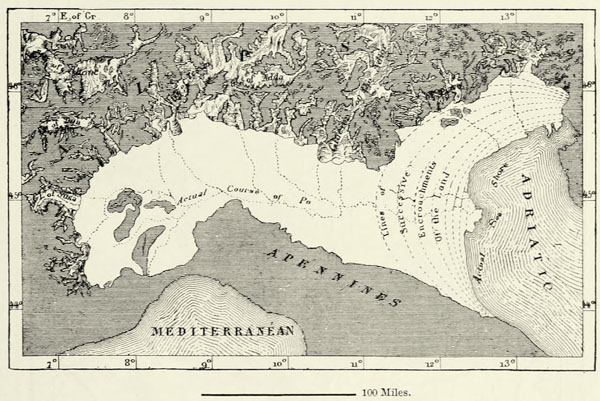
The valley of the Po is frequently spoken of as Upper Italy, because it occupies the northern portion of the peninsula, but might more appropriately be termed the Italian Netherlands, for its elevation is less than that of any other group of provinces. It is a river valley now, but during the Pliocene epoch it still formed a gulf of the sea. This gulf was gradually filled up by the alluvium brought down by the rivers, and upheaved by subterranean forces above the surface of the waters, the erosive action of the mountain torrents continuing all the while; and thus, in the course of ages, the basin of the Po assumed its gentle and regular slope towards the sea. As long as the waters of the Adriatic penetrated the valleys between Monte Rosa and Monte Viso, Italy was attached to the Alps {190} of continental Europe only by a narrow neck of land formed by the Ligurian Apennines.
Fig. 51.—MONTE VISO AS IT APPEARS FROM CHIAFFREDO.
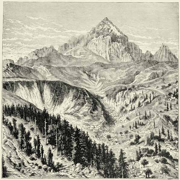
No other region of Europe can rival the valley of the Po as regards the magnificence of its distant prospects. The Apennines in the south raise their heads above the region of forests, their rocks, woods, and pasturages contrasting with the uniform plain spread out along their foot; whilst the snow-clad Alps rise in all their sublimity from the Col di Tenda in the west to the passes of Istria in the east. The isolated pyramid of Monte Viso (thus called from the beautiful prospect which may be obtained from its summit) looks down upon the fields of Saluzzo, and the small lakes in its pasturing region feed a roaring rivulet which subsequently assumes the name of Po. Enormous buttresses to the north-west of Turin support the ice-clad Grand Paradis, near which peeps out the Grivola, perhaps the most charming, the most gracefully chiselled of all Alpine peaks. Right in the bend of the Alpine chain rises the dome of Mont Blanc, like an island above a sea of mountains. Monte Rosa, crowned with a seven-pointed diadem, pushes its spurs far into Italy. Then come the Splügen, the Ortler, the Adamello, the Marmolade, and many another summit distinguished for some special beauty. When from the top of the dome of Milan we behold spread out around us this magnificent amphitheatre of mountains rising above the verdant plain, we may well rejoice that we should have lived to contemplate so grand a scene.
Geographically the Alps belong to the countries which surround Italy. From the south we seize at a glance the entire slope of the mountains, from the vineyards and plantations of mulberry-trees to the forests of beech and larch, the pastures, the naked rocks, and the dazzling fields of ice. But the cultivator only ventured into this difficult region when forced by poverty. The features of the northern slope are quite different. There the land rises gradually, and the valleys are less fertile, but the inhabitants can easily reach the heads of the passes, whence they look down upon the inviting plains of Italy. It is this structure of the Alps which explains the preponderance of the Germanic and Gallic elements throughout their extent, and whilst Italian is spoken only in a few isolated localities beyond this mountain barrier, the French and German elements are largely represented on their inner slopes.
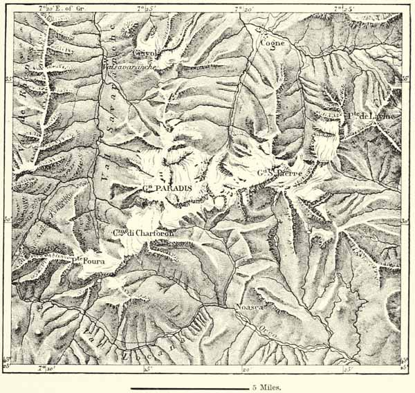
Italy can only claim a few Alpine mountain masses within the basin of the Po, the Adige, and the rivers of Venetia. The most important of these, alike on account of its height, its glaciers, and springs, is the Grand Paradis, which rears its head to the south of the Dora Baltea, between the masses of Mont Blanc and the plains of Piemont. An Englishman, Mr. Mathews, may claim to be the first discoverer of this mountain giant, which even on the Sardinian staff map, published only recently, is confounded with Mont Iseran, a far less noble summit twenty-five miles to the west of it.
None of the other Alpine summits on Italian territory can compare in height with the Grand Paradis, for though the Italian language extends in numerous instances to the central chain of the Alps, the political boundaries of Italy do not. {191} Switzerland holds possession of the valley of the Upper Ticino, whilst Austria still possesses the Upper Adige. The only rivers rising on the southern slope of the Alps, and belonging in their entirety, or nearly so, to Italy, are the Tagliamento and the Piave. In consequence of this violation of the natural frontiers there are many snow-clad Alpine summits which, though geographically belonging to Italy, are situated on the frontiers of the present kingdom, or even within Swiss or Austrian territory. Amongst these are the giant summits of the Ortler, the Marmolade, and the precipitous Cimon della Pala. The Monte della Disgrazia, however, to the south of the Bernina, is an Italian mountain; such is also, for the greater part, the mountain mass of the Camonica, bounded on the north by the Pass of Tonale, which plays so prominent a part in legendary history, and is commanded by the Adamo, or Adamello, whose glacier streams creep down to the Upper Adige. Farther to the east, in the valley of the Piave, the obelisk surmounting the huge pyramid of the Antelao pierces the line of perennial snow, and there are other peaks scarcely inferior to it in height.
Μ
Fig. 52.—GRAND PARADIS.
From the Map of the French Alpine Club. Scale 1 : 228,000.
Most of the Alpine groups lying within Italy and between the main chain and {192} the plains do not exceed the Apennines in height, and only a few amongst them are covered with perennial snow. But the prospects which may be enjoyed from them are all the more charming for this reason, for we find ourselves between two zones, with cultivated valleys, towns, and villages at our feet, and a panorama of bare and snowy summits bounding the view to the north. Several of these mountains deservedly attract large numbers of tourists. Favourites amongst them are the hills rising above the blue lakes of Lombardy, such as the Motterone on Lago Maggiore, the pyramidal Generoso rising in the midst of verdant fields on the Lake of Lugano, the superb hills between the two arms of the Lake of Como and the fertile plains of the Brianza, and Monte Baldo, advancing its buttresses like lions’ claws into the waters of the Lake of Garda. The mountains of the Val Tellina, or the Orobia range, to the south of the valley of the Upper Adda, being remote from towns and customary highways, are less frequently visited than they deserve. Standing at their foot, we may almost fancy being in the Pyrenees. As to the dolomites, on the frontiers of Venetia and the Tyrol, they are unique. Their fantastically shaped rocks, delicately tinted with pink and other colours, contrast marvellously with the green of beeches and firs, or the blue waters of the lakes. Richthofen and others look upon these isolated mountain masses as ancient coral islands, or atolls, upheaved to a height varying between 6,500 and 10,400 feet; and, whatever their geological origin may be, they certainly contribute much towards the beauty of the Alpine regions.
Fig. 53.—THE PLAIN OF DÉBRIS BETWEEN THE ALPS AND THE APENNINES.
According to Zollikofer.
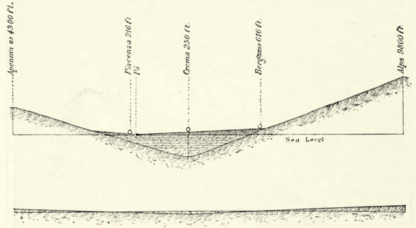
If we descend the Italian slope of the Alps, we pass gradually from the more ancient to the most recent geological formation, until we finally reach the alluvial plain. Metamorphic rocks, verrucano, dolomites, and other rocks overlie the granites, the gneiss, and the schists of the more elevated mountain masses. These are succeeded by beds of Triassic and Jurassic age. Lower still we meet with {193} terraces and hills composed of tertiary marls, clays, and conglomerates. Monte Bolca, so famous amongst geologists on account of its fossils, belongs to this formation.62 The whole of the plain of Lombardy and Piemont, with the exception of the isolated hillocks rising in it, and a few marine deposits near its margin, consists of débris brought down by the rivers. The depth of this accumulation is not yet known, for hitherto no borings have pierced it; but if we suppose the slopes of the Alps and the Apennines to continue uniformly, it would amount to no less than 4,130 feet. The two diagrams (Fig. 53) are intended to illustrate this feature. In the upper of these the heights are exaggerated tenfold; in the lower both the horizontal and the vertical scales are the same. A glance at this diagram reveals the astounding fact that the volume of this débris almost equals that of the existing mountain systems.
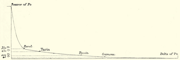
Fig. 54.—SLOPE OF THE VALLEY OF THE PO.
The vertical scale is ten times larger than the horizontal.
The vast plain stretching from the Adriatic to the foot of the Monte Rosa and the Viso may boast of its peninsulas, its islands, and even its archipelagos, as if it were a sea. The tertiary hills of Northern Monferrato, to the east of Turin, attain a height of 1,600 to 2,000 feet, and the valley of the Tanaro completely separates them from the Ligurian Alps and the Apennines. Even at the very foot of the Alps, as at Cavour and elsewhere, isolated granitic or porphyritic pyramids and domes rise in the midst of the plain sloping down towards the Po.63 The hump-backed Bosco Montello, to the south of the Piave, is another isolated hill; and on the banks of the Po may be seen a hillock of pebbles and marine sands, abounding in fossils, which bears the village of San Colombano and its vineyards. Several volcanic peaks, surrounded by cretaceous formations, rise in the midst of the plains to the east of the Lake of Garda. The craters of the Berici, near Vicenza, and of the Euganean Hills, near Padua, have not vomited {194} flames within the historical epoch, but the hot and the gas springs which issue from clefts in the trachytic and basaltic rocks prove sufficiently that volcanic forces are not yet quite extinct in that part of Italy. Earthquakes occur frequently in the neighbouring Alps, and particularly near Belluno and Bassano.
Μ
Fig. 55.—MUD VOLCANOES AND HOT SPRINGS OF THE NORTHERN APENNINES.
Scale 1 : 1,160,000.
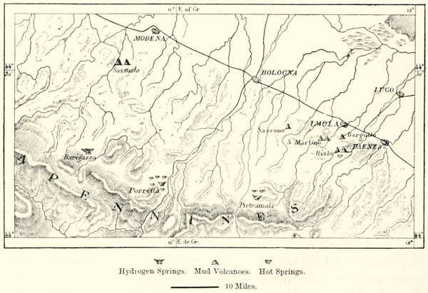
A similar volcanic zone extends along the northern slope of the Apennines, which bound the valley of the Po on the south. Hydrogen gas escapes from fissures in the rocks to the south of Modena and Bologna, and is utilised in several instances in the manufacture of lime, and for other purposes. These gas springs of Pietra Mala, Porretta, and Barigazzo were known by the ancients and during the Middle Ages as “fiery springs,” and they illuminated the path of the traveller overtaken by the night. Lower down the slope, almost on the verge of the plains, we meet with a line of mud volcanoes, or bombi, the most famous of which are those of Sassuolo, near Modena. The largest of these, that of Mirano, has no less than forty craters. The ancient gulf of the sea, now converted into a plain, is thus skirted by volcanic cones, mud volcanoes, hot springs, and deposits of sulphur. As high up as Piemont, and notably at Acqui, we meet with hot springs, attesting that volcanic activity is not yet altogether extinct.
La Dent blanche, 14,319 ft. Château des Dames, 11,998 ft. Mt. Cervin, 14,705 ft. Mischabel Hōrner, 14,942 ft. Breithorn, 13,680 ft. Monte Rosa (Dufour Spitze, 15,217 ft.).
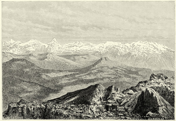
THE PENNINE ALPS, AS SEEN FROM THE BECCA DI NONA (PIC CARREL), 10,380 FEET.
The valleys of the Alps and the plains extending along their foot were filled, in a former geological epoch, with huge glaciers, descending from what was anciently the immense glacial region of Central Europe. There is not a valley between that of the Tanaro in the west, and that of the Isonzo descending from the mountains of Carinthia, but contains accumulations of débris carried down by the {195} glaciers, and now covered with vegetation. Most of these ancient glaciers exceeded those of the Monte Rosa and the Finsteraarhorn in extent, and several of them rivalled the existing glaciers of the Himalaya. If we would gain a notion of what the Alps were like during this glacial epoch, we must go to Greenland or to the Antarctic regions.
Μ
Fig. 56.—THE ANCIENT GLACIERS OF THE ALPS.
Scale 1 : 4,800,000.
One of the smallest of these ice streams, that which descended from the mountains of Tenda in the direction of Cuneo, had a length of thirty miles. That which brought down the ice of Mont Genèvre, Mont Tabor, and Mont Cenis had twice that length, and its moraines formed a veritable amphitheatre of hills, locally known as regione alla pietre, or stony region. Farther north the streams of ice descending from the Pennine Alps between the Grand Paradis and Mont Blanc united in a single stream eighty miles in length, and spread over the plain far beyond Ivrea. The alluvial accumulation of this ancient glacier rises 1,100 and even 2,130 feet above the valley through which the Dora Baltea now flows. One of its lateral moraines, known as the Serra d’Ivrea, forms a regular rampart to the east of the river, eighteen miles in extent. Its slopes are now covered with chestnuts. The western ravine (Colle di Brossa) is less prominent, because it is inferior in height; but the frontal ravine, forming a complete demicircle, can still be traced readily. In the débris accumulated at the foot of this ancient glacier, rocks derived from Mont Blanc are mixed with others brought down from Mont Cervin. And yet it was but a dwarf when compared with the ancient twin glacier of the Ticino and the Adda, which extended from the Simplon to the Stelvio, filled up the cavities now occupied by the Lago Maggiore {196} and the Lake of Como, sent a lateral branch to the tortuous bed of the Lake of Lugano, and finally, after a course of from 100 to 120 miles, debouched upon the plain of Lombardy. The glacier of the Oglio was small in comparison with it, but it was exceeded by that of the Adige, the most considerable of all on the southern slope of the Alps. This river of ice, from the mountains of the Oetzthal, where it originated, to its terminal moraine to the north of Mantua, had a length of 175 miles. One of its branches descended towards the east, down the valley of the Drave, as far as where the town of Klagenfurt now stands. Its main stream filled up the cavity of the Lake of Garda, pushing along a formidable rampart of elevated moraines.
Μ
Fig. 57.—THE SERRA OF IVREA AND THE ANCIENT GLACIER LAKES OF THE DORA.
From the Sardinian Staff Map. Scale 1 : 250,000
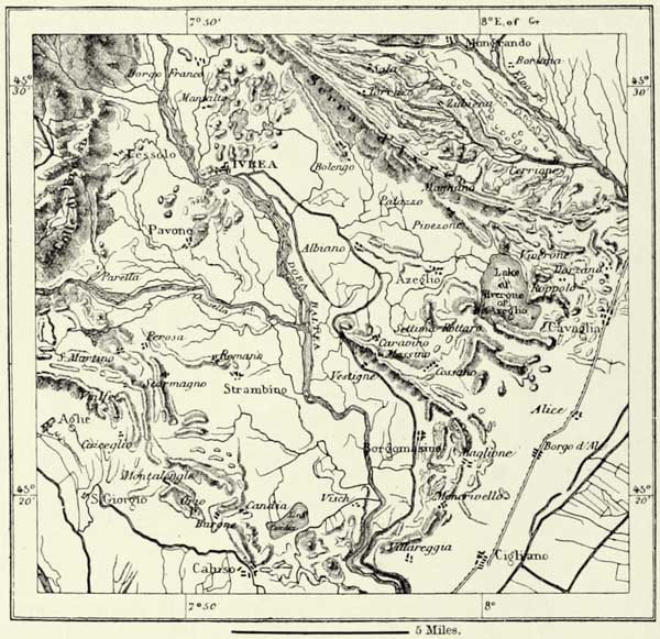
The hand of man is scarcely able to make an impression upon the vast accumulations heaped up by the action of the glaciers. The hills of Solferino, of Cavriana, and Somma Campagna, so often named in connection with battles, are nothing but débris brought down from the flanks of the Alps, and they were much higher formerly than they are now. {197}
Some of the erratic blocks were as large as houses, but, being used as quarries, they are fast disappearing. One of them at Pianezza, at the mouth of the Susa valley, is 80 feet long, 40 feet broad, and 46 feet high, and a chapel has been built upon it. The huge erratic blocks in the hills between the two arms of the Lake of Como have supplied materials for the monolithic columns of the churches and palaces in the environs. The slopes of the hills of Turin facing the Alps are likewise covered with erratic blocks.
When the glaciers retired into the upper valleys of the Alps, the soil which they covered was left bare, and the depressions now occupied by the beautiful lakes of Lombardy were revealed. These depressions, whose bottom even now sinks down below the level of the ocean, were formerly arms of the sea, in character very much like the fiords of Norway. That such was the case is proved by the presence, in every one of the Lombard lakes, of a sardine (the agone), which naturalists consider to be a sea fish. In Garda Lake, moreover, there still dwell two marine fishes which have adapted themselves to their new condition of life, as well as a small marine shell-fish.
Μ
Fig. 58.—ANCIENT LAKES OF VERBANO.
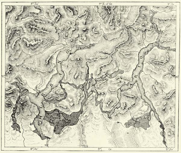
The number of these Alpine lakes was much larger formerly, and those which still exist shrink from year to year. In Upper Piemont alluvial deposits have long ago filled up the lakes, and there now only remain a few pools of {198} water to indicate their site. The first sheets of water to which the term “lake” may fairly be applied are met with on both banks of the Dora Baltea (see Fig. 57). The little basin of Candia and the shallow Lake of Azeglio, to the west and east of the river, are the only remains of Lacus Clisius, which covered an area of several hundred square miles until its waters broke through the semicircular terminal moraine which bounded it on the south. The Dora Baltea formerly escaped from this lake in the south-east, its present course only dating from the fourteenth century.
Μ
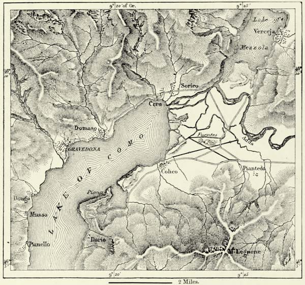
Fig. 59.—THE UPPER EXTREMITY OF THE LAKE OF COMO.
Scale 1 : 148,000.
Since this reservoir has been drained, the first lake of importance in the west is that of Verbano, very inappropriately called Lago Maggiore, or the “principal lake,” as that of Garda exceeds it in extent. Ancient beaches, at an elevation of 1,300 feet above the sea, prove that the waters of the lake have considerably subsided, and that its area was much larger formerly; and it curiously ramified with neighbouring lake basins, now merely connected with it by rivers. The ancient moraine at the foot of this lake, and through which the Ticino has excavated itself a passage, still rises to a height of 980 feet. {199}
Centuries elapsed before the changes which we now perceive were accomplished. Still they proceeded at a sufficiently rapid rate. Even now the alluvium carried down by the Ticino and the Maggia continually encroaches upon the Lago Maggiore. Seven hundred years ago the village of Gordola stood on the shore of the lake: it is now nearly a mile away from it. The landing-places of Magadino, at the mouth of the Ticino, have to be continually shifted, for the lake retires steadily. Only sixty years ago barges were able to receive their cargoes at a wharf nearly half a mile higher up than the present one. The Gulf of Locarno is gradually being separated from the main sheet of water by alluvial deposits brought down by the Maggia.
Fig. 60.—SECTION OF THE NORTHERN PORTION OF LAKE COMO.
Scale 1 : 25,000.
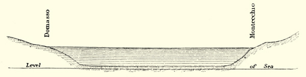
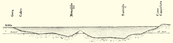
Fig. 61.—SECTION OF THE LAKE OF LECCO, NEAR THE BIFURCATION.
Scale 1 : 25,000.
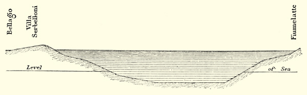
Fig. 62.—LONGITUDINAL SECTION OF LAKE COMO.
Horizontal scale 1 : 50,000. Vertical scale 1 : 500,000.
The Lario, or Lake of Como, which rivals the Maggiore by its beauty, is likewise being gradually silted up. In the time of the Romans the navigation extended as far as Summolacus (lake-head), the modern Samolaco. But the torrent of Mera gradually converted most of the upper extremity of the lake into an alluvial plain, whilst the alluvial deposits carried down by the Adda cut off the remainder from the main body of water. There now remains only the Lacus {200} Dimidiatus, or Lake of Mezzola, which is shrinking from year to year, and will finally disappear altogether. The miasmata rising from the swamps at the mouth of the Adda have frequently depopulated the environs, and the ruined fort of Fuentes, at the mouth of the river, built to defend the Val Tellina, was hardly ever more than a hospital for its fever-stricken garrison.
The south-eastern arm of the lake, that of Lecco, through which the Adda makes its escape to the south, has likewise been divided into a series of separate basins. Nature, which would convert these lakes into bottom-lands at no distant date, is being aided here by the works of man. The barrier which obstructed the free egress of the Adda has been cleared away, the structures of fishermen have been removed, and, in consequence of these and other engineering measures, the once-dreaded rises of the lake have been reduced to a minimum, and the southernmost of the lake basins, that of Brivio, has been converted into dry land. The large Lake of Brianza, which extended formerly far to the south-west, has likewise been partially drained, and there now remain only a few lakelets of small extent.
We know sufficient of the bottom of the Lake of Como to enable us to judge of the manner in which it is becoming gradually filled up with alluvium. The mud deposited in its northern portion has filled up all the original inequalities of the soil, and even in the centre of the lake, and in its south-eastern arm, the bottom is almost a perfect level. In the Como arm, however, which receives no tributary river of any importance, the bottom is still full of inequalities. These differences amply prove to us the geological agency of the rivers, which must terminate in the lake being converted into a bottom-land, with a river flowing through its centre. The third of our diagrams (Fig. 62) shows that the greatest depth now hardly exceeds 1,300 feet, whilst, if we may judge from the slopes of the hills which bound it, the depth in former times cannot have been less than 2,300 feet.
The Sebino, or Lake of Iseo, and the lakelet of Idro, which are fed by the glacier streams of the Adamello, exhibit the same features as the lakes farther to the west. The Benaco, or Lake of Garda, however, the most extensive of these Alpine lakes, is very stable as regards its outline and the configuration of its bottom, a fact sufficiently explained by the small size of its tributary streams as compared with its vast area. The old Alpine lakes of the Venetian Alps have disappeared long ago, and there remain only a few ponds, filling cavities in the dolomitic rocks and peat bogs, to indicate their ancient sites.64 {201}
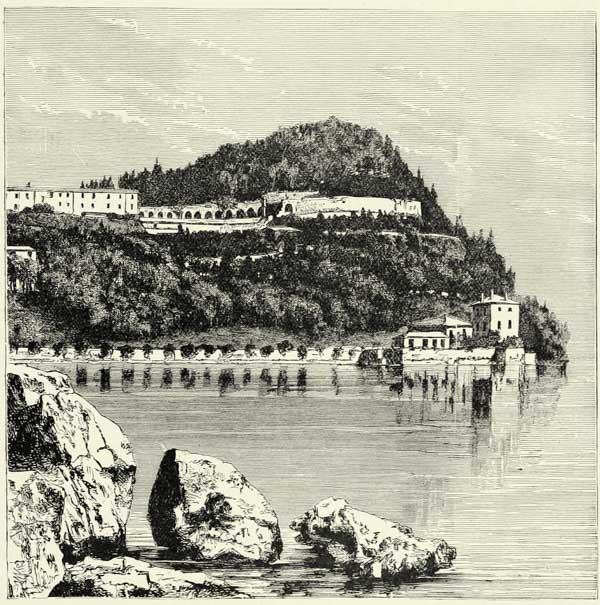
Fig. 63.—VILLA SERBELLONI, ON THE PENINSULA OF BELLAGIO, LAKE OF COMO.
These lacustrine basins, like all other reservoirs of the same kind, regulate the outflow of the torrents which empty into them. During the freshets they store up the superabundant waters, and only part with them in the dry season, and upon their difference of level in different seasons depend the oscillations of the emissary rivers which issue from them. In the case of the Lake of Garda, which drains but a small area in proportion to its size, this difference is small, and throughout the year the pellucid waters of the Mincio flow tranquilly beneath the blackened ramparts of Peschiera. Such is not the case as regards either the Lago Maggiore or the Lake of Como, for the volume of water discharged into them is so considerable that their level in summer and winter varies to the extent of several yards, and corresponding differences may be observed in the rivers issuing from them. Lake Como rises no less than 12 feet, and increases 70 square miles in area, whilst the Lago Maggiore sometimes rises 22 feet, and {202} increases to the extent of one-fifth. The volume of the Ticino, when at its highest, almost equals the average volume of the Nile, and if it were not for the regulating influence of the lake from which it issues, it would alternately convert the plains of Lombardy into a sheet of water and leave them an arid tract of land.65
The Alpine lakes of Italy thus play an important part in the economy of the country. They render the climate more equable, serve as high-roads of commerce, and, being the centres of animal life, attract a dense population. But it is not this which has rendered these lakes famous, which has attracted thousands of wanderers ever since the time of the Romans, and caused villas and palaces to rise on their shores: it is their incomparable beauty. And, indeed, there are few spots in Europe which bear comparison with the delightful Gulf of Pallanza, over which are scattered the Borromean Islands, or with the peninsula of Bellagio, which may be likened to a hanging garden suspended within sight of the snow-clad Alps, and affording a prospect of the rock-bound shores of the Como Lake, cultivated fields, and numerous villas. Perhaps even more delightful is the peninsula of Sermione, jutting out into the azure waters of the Garda Lake, like the tender stalk of a flower developing into a many-coloured petal.
Most of the lakes in the plain have been drained into the neighbouring rivers. The Lake of Gerondo, mentioned in mediæval records, has dwindled down into a small swamp, or mosi, now, and its populous island of Fulcheria has become merged in the plain of Lombardy. The lakes on the southern bank of the Po, above Guastalla, have likewise been drained; and if the two shallow lakes of Mantua still exist, this is entirely due to the embankments raised in the twelfth century. It would have been much better, and would have saved the city the horrors of many a siege, if these lakes had been allowed to disappear likewise.
The lagoons along the Adriatic have decreased in extent in the course of centuries, and whilst new lagoons are being formed, the old ones are gradually being converted into dry land. The old maps of the Venetian littoral differ essentially from our modern ones, and yet all the vast changes they indicate have been wrought in the course of a few centuries. The swamps of Caorle, between the Piave and the Gulf of Trieste, have changed to an extent which prevents us from restoring the ancient topography of the country; and if the lagoons of Venice and Chioggia exhibit a certain permanence of contour, this is only on account of the incessant interference of man. The ancient lagoon of Brondolo has been dry land since the middle of the sixteenth century. The large lagoon of Comacchio, to the south of the Po, has been cut up into separate portions by alluvial embankments formed by the agency of rivers and torrents. For the most part it consists now of valli, or alluvial deposits, but there still remain a few profound cavities, or chiari, which the rivers have not yet succeeded in filling up. Formerly these {203} lagoons extended far to the south in the direction of Ravenna, and, according to Strabo and other ancient writers, that ancient city once occupied a site very much like that of Venice or Chioggia in our own days.
Μ
Fig. 64.—BEECH AND PINE WOODS OF RAVENNA.
Scale 1 : 2,470,000.
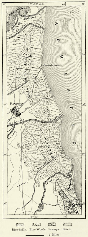
There can be no doubt that these lagoons were anciently separated from the Adriatic by a narrow strip of land over 120 miles in length, and similar to what we still meet with on the coasts of Carolina and of the Brazils. This ancient barrier still exists in the lidi of Venice and Comacchio, which are pierced at intervals, admitting the vivifying floods of the open sea. Elsewhere the traces of this ancient beach must be looked for on the mainland. The low delta of the Po is traversed from north to south by a range of dunes constituting the continuation of the lidi of Venice, and extending into the swamps of Comacchio, where they form a natural embankment running parallel with the coast. These dunes, between the Adige and Cervia, are covered with sombre pine woods, replaced here and there by oaks. The underwood mainly consists of hawthorns and juniper-trees, and wild boars still haunt it.
No sooner have the lagoons protected by these barriers been converted into dry land than the sea seizes upon the sand, and forms it into new curvilinear barriers similar to the former ones. The principal range of dunes to the east of Ravenna, which is about 20 miles in length, and varies in width between 50 and 3,300 yards, has thus two other ranges of dunes running parallel with it, one of them being still in course of formation. Signor {204} Pareto has estimated the annual advance of the land at 7½ feet, and at much more near the mouths of rivers.
The sea thus marks by a series of barriers its successive recoils. Sometimes, however, the sea gains upon the land in consequence of a gradual subsidence of the Venetian shore, the cause of which has not yet been elucidated. Thus the gravel bank of Cortellazzo, opposite the swamps of Caorle, appears to have anciently been a lido which has sunk nearly 70 feet below the level of the sea. The islands which fringed the littoral of Aquileja during the Middle Ages have almost wholly disappeared. In the time of the Romans these islands were populous; there were forests and fields upon them, and the inhabitants built ships. The chronicles of the Middle Ages tell us that the Doge of Venice and the Patriarch of Aquileja hunted stags and wild boars upon them, much to the scandal of the inhabitants. At the present day the dunes which of yore protected these islands have almost wholly disappeared, the forests have been supplanted by reeds, and Grado is the only place on the littoral which may still boast of a certain number of inhabitants. Piers, walls, mosaic pavements, and even stones bearing inscriptions, which are found occasionally at the bottom of the sea or of swamps, prove that the mainland was formerly more extensive there. Farther to the west the littoral of Venice bears evidence of a similar subsidence. Artesian wells sunk in the city of the lagoons have led to the discovery of four beds of turf, the deepest no less than 420 feet below the level of the sea. The subterranean church of St. Mark has within historical times been converted into a submarine church, and streets and buildings are gradually sinking beneath the waters of the lagoons. If it were not for the alluvium brought down by the rivers, the sea would continually encroach upon the land. Ravenna, too, participates in this subsidence, which Signor Pareto estimates to amount to 0·60 inch in the course of a century.
Amongst the geological agents constantly at work to modify the surface of the earth, the rivers and torrents irrigating the plain lying at the foot of the Alps are the most active, and no other country of Europe, Holland alone excepted, can compare in this respect with Northern Italy.
The torrent of Isonzo offers one of the most striking instances of these geological revolutions. It is said to have formerly communicated through subterranean channels with the Istrian Timavo, and that its existence as a separate river does not date very far back. Ancient writers do not enumerate the Isonzo amongst the rivers flowing into the Adriatic. It is first mentioned in a document of the sixth century as a river irrigating some inland valley. On Peutinger’s Table we meet with a station, Ponte Sonti, far to the east of Aquileja, and near the sources of the Timavo. The chronicles are silent with respect to the peripatetics of this river, but a careful examination of the surrounding hills justifies the assumption that the valley of Tolmein, on the Upper Isonzo, was formerly a lake which overflowed towards the north-west through the narrows of Caporetto, and that its pent-up waters found their way through the Natisone into the Adriatic. Subsequently they opened themselves a passage to the south, and another lake was {205} formed at the confluence of Isonzo and Wippach. This lake communicated by subterranean channels with the Timavo, but it has now disappeared, and the Isonzo flows directly into the sea, its bed wandering continuously towards the east. The alluvium carried down by this river has formed the peninsula of Sdobba, and joined several old islands to the mainland.
Μ
Fig. 65.—SHINGLE BEDS OF THE TAGLIAMENTO, THE MEDUNA, AND ZELLINE.
From the Austrian Staff Map. Scale 1 : 290,000
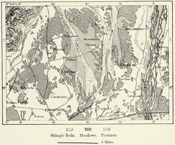
The Tagliamento is even a more active geological agent than its neighbour just beyond the frontier. The débris deposited at the mouth of the narrow gorge in which it rises covers many square miles of a once fertile plain. In summer its waters trickle through these accumulations of shingle, but after heavy rain the river is converted into a powerful torrent several miles in width, and all the more formidable as its bed lies higher than many parts of the surrounding country. The Meduna and Zelline, to the west of the Tagliamento, are equally destructive, and an extensive tract at their confluence is covered with shingles. Lower down, in the lagoons, these torrents have thrown up huge embankments of sand on either side of their ancient beds. The alluvium brought down by these torrents to the sea is in every instance deposited to the west, a circumstance accounted for by the direction of the coast current.
The Piave, the most considerable river to the east of the Adige, is likewise a most active geological agent, converting fertile fields into sterile shingle tracts, filling up swamps, and carrying large quantities of matter into the sea. At its {206} mouth the land gains rapidly upon the sea, and Heraclea of the Veneti, now known as Cittanova, which was a seaport once, at the present time lies far inland.
The Piave was formerly supposed to have changed its bed in the same manner as the Isonzo. Below the Capo di Ponte, a wild defile in the Dolomite Alps, the Piave flows towards the south-west, past Belluno, and lower down is joined by the Cordevole. It was, however, supposed that the river originally flowed through the valley of Rai, immediately to the south of the Capo di Ponte, and that the Meschio and Livenzo constituted its lower course. Earthquakes or landslips were supposed to have created a barrier across that valley, and the small lakes still seen there were looked upon as remains of the ancient river bed. But M. de Mortillet has shown that this hypothesis is untenable, for the barrier referred to is merely the moraine of an ancient glacier, and there exist no traces whatever of landslips.
Μ
Fig. 66.—THE SUPPOSED OLD BED OF THE PIAVE.
From the Austrian Staff Map. Scale 1 : 550,000.
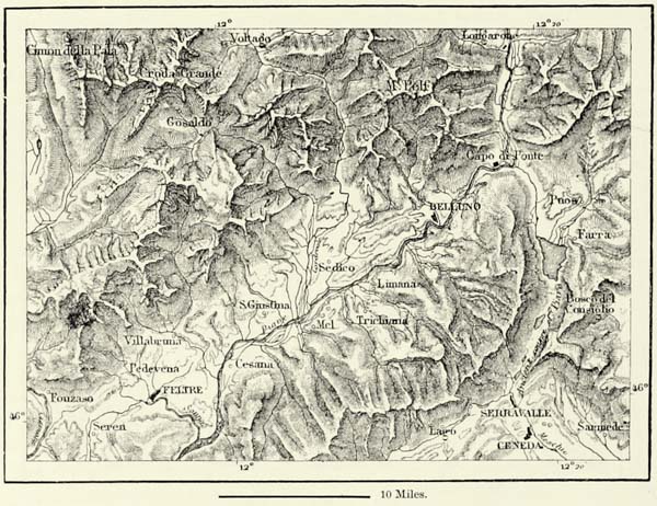
At the same time it cannot be doubted that extensive changes have taken place in the basin of the Piave. Thus in 1771 the course of the Cordevole, its most important tributary, was obstructed for a time by a landslip which carried the verdant terraces of Pezza down into the valley. Two villages were destroyed, and two others overwhelmed by the rising floods of the river.
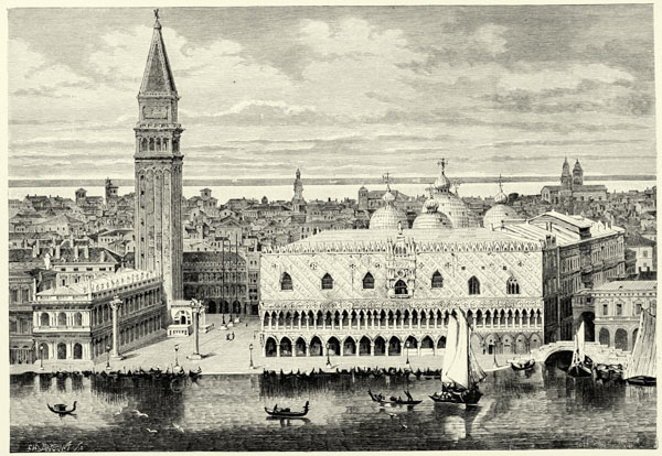
VENICE.
Μ
Fig. 67.—THE LAGOONS OF VENICE.
Scale 1 : 394,000.
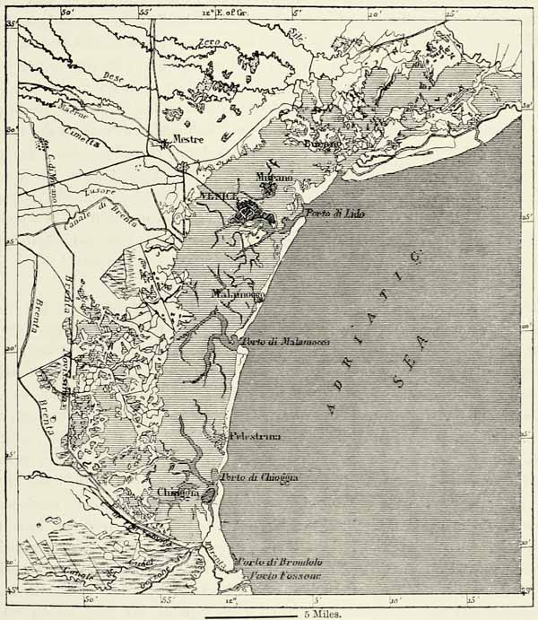
The Brenta, which rises in the beautiful Sugana valley of the Tyrol, has at all times been a source of anxiety to the Venetians on account of its irregularities. Formerly it entered the lagoons at Fusina, and its alluvium filled up the canals {207} and infected the air. The Paduans and other inhabitants of the lowlands were anxious to divert it by the most direct course into the lagoons, so as to avoid inundations, whilst the Venetians were solicitous to get rid of a river which threatened to fill up their lagoons and render them insalubrious. These conflicting interests gave rise to numerous wars. The possession of the coast became a question of existence to the Venetians, and no sooner had they obtained it than they set about “regulating” the Lower Brenta. Hy means of two canals, the Brenta Nuova, or Brentone, and the Brenta Nuovissima, the river was conducted right round the lagoons to the port of Brondolo, a few miles to the north of the Adige. But the river, whose course had thus been considerably lengthened, gradually filled up the bed in its upper course, and it was found impossible to {208} confine it within its lateral embankments. They were broken through by the floods no less than twenty times between 1811 and 1859, and, as the channel of the river became more and more choked, a more frequent recurrence of such disasters was naturally expected. It was then resolved to shorten the course of the river to the extent of ten miles, by diverting it into a portion of the lagoon of Chioggia. The danger of irruptions has thus been averted for a time, but the fisheries of Chioggia have been completely destroyed, and fever is a frequent visitor in the towns of the littoral.
There can be no doubt that but for the efforts of the Venetian engineers the lagoons of the Lido, Malamocco, and Chioggia would long ago have been converted into dry land. Venice has at all times been alive to the necessity of preserving its precious inland sea. The Venetian engineers were not content with turning aside the torrents which formerly poured their waters into the lagoons; they have also, by means of canals, moved the mouths of the Sile and Piave to the east, thus securing the ports of the Lido from the dreaded alluvium of the rivers. They even conceived the gigantic project of a huge encircling canal for the interception of all the Alpine torrents between the Brenta and Isonzo. This project, however, has never been carried out. The débris carried southward by the coast current has silted up the port of the Lido, which was abandoned towards the close of the fifteenth century, when a new military port was constructed eight miles farther south, at the canal of Malamocco, and it is now protected by a pier extending 7,200 feet into the sea.
The torrents which descend from the slopes of the Apennines to the south of the delta of the Adige and Po are as erratic in their course as those of Venetia. The Trebbia, the Taro, and other rivers irrigating the districts of Piacenza and Parma only cross a narrow plain between the mountains and the Po, and do not much modify the topography of the country. But this cannot be said of the rivers flowing through the vast plains of Modena, Bologna, Ferrara, and Imola. They are constantly changing their beds, and the remains of embankments met with all over the country prove that all efforts to confine them permanently have proved abortive. Modena itself was once destroyed by the floods of the Secchia. The Tanaro, the Reno, and other rivers flowing towards the north-west, either into the canal encircling the lagoons of Comacchio or direct into the sea, all have a history attached to them; they are blessed for their fertilising alluvium, cursed on account of their destructive floods. One of them, probably the Fiumicino, is the famous Rubicon which bounded the Italy of the Romans, and which was crossed by Cæsar when he pronounced the fatal words, “Alea jacta est.”
The Reno is the most erratic, the most dangerous of all these Apennine rivers. The bed of débris deposited by it in the plain measures 20 miles across from east to west. Its volume varies between 35 and 49,500 cubic feet a second, according to the season, and its bed is in places no less than 30 feet above the adjoining country. The destruction of the forests has augmented the danger of its inundations. The engineers, puzzled by its irregular floods, have proposed the most {209} opposite plans for subduing this terrible scourge. The river has been turned into the Po; then eastward, direct into the sea. Recently it has been proposed to divert it to the lagoons of Comacchio. But all these diversions are attended with disadvantages, and whilst the inhabitants of one district congratulate themselves upon having got rid of so troublesome a neighbour, those of another complain of its inundations, see their fisheries destroyed, and their navigation interfered with.
Μ
Fig. 68.—COLONIES OF THE ROMAN VETERANS.
Scale 1 : 356,000.
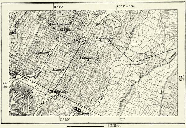
Lombardini, the famous hydraulic engineer, has shown how we may discover the places to which the soil of the lowlands of Emilia has been conveyed by the torrents, and trace the ancient shores of the lagoon of Padua, now converted into dry land. A traveller following the Emilian causeway from Cesena to Bologna can hardly help noticing the quadrangular fields on his right, all of them of the same size. Looked at from the spurs of the Apennines, the plain resembles a huge draught-board, the squares of which are covered alternately with verdure and ripening crops. We learn from the topographical maps that these fields are exactly of the same size, and there can be no doubt that we have here before us the fields which, according to Livy, were taken from the Gauls and distributed amongst Roman military settlers. A sinuous line marks, in the direction of the Po, the shore of an ancient lake. The rectangular fields, laid out by the cadastral surveyors of ancient Rome, cease there, and we find ourselves again amidst the usual labyrinth of ditches and tortuous roads. This lake has been filled up long ago by the débris brought down by the torrents. {210}
The Po, proportionately to the area it drains and its length, has undergone fewer changes than either the Piave or the Reno, but looking to the populous cities which line its banks, and to the fertility of its fields, the least of these is of some importance.
The torrent fed by the snows of Monte Viso is usually looked upon as the head stream of Father Po, as the ancient Romans called the river; but the Mastra, Varaita, and Clusone are quite equal to it in volume, and feed as many canals of irrigation. Indeed, these canals would quickly drain the Po if it were not for a bountiful supply of snow-water brought down by the Dora Riparia, the Stura, the Orca, and the Dora Baltea from the glaciers of the Alps. Lower down, the Po receives the Sesia from the north, and the Tanaro, which is fed by streams rising in the Apennines and the Alps. Then comes the Ticino, by far the most important tributary of the Po, “without which,” as the river fishermen say, “il Po non sarebbe Po.”
The Po, after its junction with the Ticino, exhibits no longer the features of a mountain torrent; the pebbles have been triturated into the finest dust, and no piled-up masses of débris are met with along its banks. If it were not for its dykes, or argini, it might spread itself freely over the plain. These artificial embankments rival those of the Netherlands, and date back to the most remote ages. Lucian refers to them as if they had existed from time immemorial. During the great migration of peoples they were allowed to decay, and only in the course of the ninth century were measures taken to restore them. In 1480 the great work had been achieved. Its importance may be judged from the fact that these embankments protect 3,000,000 acres of the most fertile land, yielding annually more than £8,000,000 sterling’s worth of agricultural produce. Most of the towns have been built upon artificial platforms or terraces, and up to the beginning of this century they have never been known to suffer from floods; but whether owing to the devastation of the forests or to the closing up of all breaches in the dykes, the floods rise higher now than they did of yore, and it has been found necessary to throw up embankments around Revere, Sermide, Ostiglia, Governolo, Borgoforte, and other places.
Μ
DELTA OF THE PO
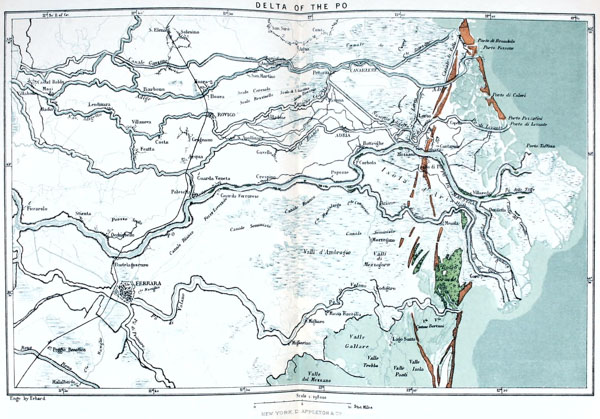
Continuous embankments begin at Cremona, and they extend not only along both banks of the Po, but also along the lower course of its tributaries. The main dykes have a length of nearly 650 miles. In addition to these there are smaller dykes traversing the space between these froldi, or main dykes, in all directions, and enclosing willow plantations, fields, and even vineyards. In fact, the river extends to the foot of the main dykes only in a few localities. It is ordinarily only 650 to 1,600 feet wide, whilst the dykes are several miles apart, to allow the river to spread during the inundations. The land thus lying within the dykes has been divided by the villagers into golene, and is protected by smaller dykes against ordinary floods. The rules laid down for the construction of embankments have been drawn up in the general interest, and are sufficiently precise, but they are not always observed. The old system, embodied in the dreadful proverb, “Vita mia, morte tua,” is not yet quite extinct. Formerly the peasants were in the habit of {211} crossing over to the other bank, and deliberately cutting through the embankments there, thus saving their own crops by ruining their neighbours’.
Μ
Fig. 69.—THE PO BETWEEN PIACENZA AND CREMONA.
From the Austrian Staff Map. Scale 1 : 325,000.
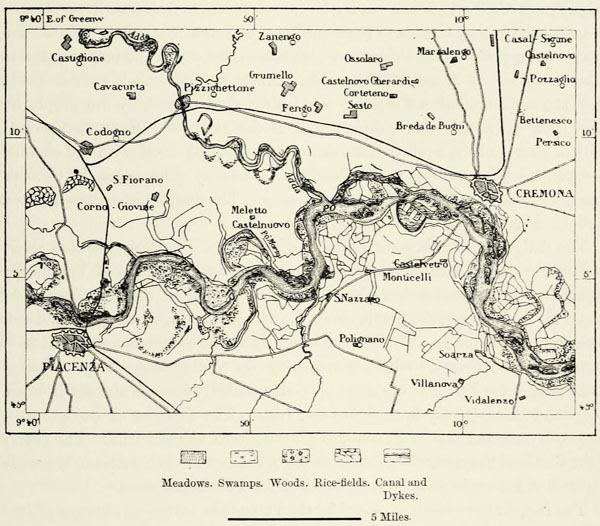
The width of the bed of inundation enclosed between these embankments grows less in proportion as we descend the river, and in the case of the arms of the delta does not exceed 900 to 1,600 feet. This is not sufficient to enable the waters to escape during extraordinary floods, when they sometimes rise 25 and even 30 feet. Besides, it frequently happens that the villagers fail to keep the embankments in thorough repair, and sometimes entire districts are ruined because the mole-tracks were not stopped up. A breach in the embankment, unless quickly filled up, produces untold misery. The crops are destroyed, the villages levelled with the ground, the soil is torn up and carried off, and the inhabitants are swept away by famine and its fearful attendant, typhus fever. These great floods of the Po and the earthquakes of Calabria are the two plagues of Italy. In 1872 1,200 square miles between the Secchia and the sea were converted into a lake. Two years afterwards there still remained pools of water.
In these great disasters the inhabitants are afforded an opportunity of exhibiting their valour, and it is always the most energetic who succeed in protecting their property from being washed away by the floods. During the flood just referred {212} to, the inhabitants of the little town of Ostiglia fought successfully with the rising waters, whilst many of their neighbours succumbed. The town stands close to the froldo, and there is no second line of dykes to protect it. The dyke threatened to give way. The inhabitants at once set about throwing up a second barrier. All the able-bodied men of the place, 4,000 in number, turned out to work, headed by their mayor. They worked day and night, and, as the floods carried away the old dyke, the new one rose in its rear. The victory was won; the floods retired, and their houses were safe.
Some of those breaches in the dykes have led to permanent changes in the course of the river, and these divagations have been most considerable in the delta. During the time of the Romans, and up to the thirteenth century, the Po di Volano was the principal branch of the river, whilst now it has dwindled down to an insignificant ditch which can hardly be traced through the swamps of Comacchio. Two other branches, farther to the south, are used now as carriage roads. In the eighth century the Po di Primaro, which enters the sea to the north of Ravenna, took the place of these old channels. Another bifurcation ensued in 1152, when the embankment at Ficcarolo was destroyed, it is said, by the people living above that town, and the main channel of the river, the Maestra, deserted the walls of Ferrara in the midst of its swamps, and united itself with the channels of the Adige. Breaches in the embankments usually take place in October or November, and generally at the same places. The danger is always greatest at Corbola, where the Po di Maestra bifurcates.
The Adige is quite as great a wanderer as the Po. Scarcely has that river left its defile, or chiusa, of calcareous mountains and the fortifications of Verona than it begins its erratic course over the plain. In the time of the Romans the Adige flowed much farther to the north, along the foot of the Euganean Hills, and entered the sea at Brondolo. In 587 the river broke through its embankments, and its main branch took the direction which it maintains up to the present day, entering the sea at Fossone. But new channels opened repeatedly towards the south, until the Adige and Po conjointly formed but one delta. The Polesina of Rovigo, between the two rivers, and that of Ferrara, are low tracts of alluvial land. The courtyard of the Castle of Ferrara, which occupies one of the most elevated sites in these plains, is nine feet lower than the highest level of the Po when flooded.
The frequent inundations caused by the Po and the numerous changes of its bed, by spreading the alluvium all over the country, have raised the whole of the plains to about the same level. But now, when all the arms of the Po are confined within embankments, most of the alluvium brought down by the floods is deposited on the coast of the Adriatic. The land, therefore, gains much more rapidly upon the sea than it did formerly. The series of dunes marking the ancient shore now lies fifteen miles inland, and the new land formed annually is estimated at 280 acres. In exceptional years the quantity of solid matter carried by the river into the sea amounts to 3,531,000,000 cubic feet; on an average it is 1,623,000,000 cubic feet, sufficient to form an island ten square miles in area in ten feet of water. The Po, next to the Danube, is the most active geological agent amongst all the rivers {213} entering the Mediterranean.66 The Rhone is inferior to it, and so is the Nile. At the present rate of progress, the Po, in the course of a thousand years, will throw a tongue of land six miles wide across the Adriatic, converting the Gulf of Trieste into an inland sea.
Northern Italy, in addition to these numerous rivers, possesses one of the most extensive systems of canals in the world, which has served as a pattern to all the rest of Europe. Lombardy, portions of Piemont, the Campagna of Turin, the Lomellina on the Ticino, and the Polesinas of Ferrara and Rovigo possess a wonderful ramification of irrigation, which carries fertile alluvium to the exhausted fields. In the Middle Ages, when the remainder of Europe was still shrouded in darkness, the Lombard republics already practised the art of irrigation on the vastest scale, and drained their low-lying plains. Milan, after she had thrown off the yoke of her German oppressors, towards the close of the twelfth century, constructed the Naviglio Grande, a ship canal derived from the Ticino, thirty miles distant—probably the first great engineering work of the kind in Europe. In the beginning of the thirteenth century the superabundant waters of the Adda were utilised in filling the Muzza Canal. The same river, at a subsequent period, was made to feed another canal, the Martesana, which was constructed by the great Leonardo da Vinci. The art of surmounting elevations of the ground by means of locks had been discovered by Milanese engineers about a century before that time, and was applied to the construction of secondary canals. Amongst works of more recent date are the naviglio from Milan to Pavia; the Cavour Canal, fed by the Po, below Turin; and the Canal of Verona, derived from the Adige.67
Not only the rivers of Northern Italy, but also the springs, or fontanelle, however small, which burst forth at the foot of the Alps, are utilised for purposes of irrigation. Virgil alludes to these springs in his Bucolics, where he says, “Children, stop the water; the meadows have drunk enough.” Lombardy is indebted to these springs for her fine prairies, or marcite, which sometimes yield eight crops a year. The great Adriatic plain has indeed undergone vast changes through the work of man. Originally it was a swamp surrounded by forests and heaths, but is now one of the best-cultivated countries of Europe. One of its great features consists in plantations of mulberries, the uniformity of which is relieved in many districts—and especially in the Brianza of Como, that {214} garden of Italy—by groups of tall trees, little lakes, and sinuous valleys. There still remain extensive heaths covering the moraines of ancient glaciers, which become more and more sterile from year to year; but the engineers are considering schemes for irrigating them by means of the fertilising waters of the Alpine lakes.
The irrigated area in the valley of the Po nearly amounts to 5,000 square miles, and the water it absorbs every second is estimated at 35,000,000 cubic feet, equal to about one-third of the volume of the Po. If the proposed works of irrigation are carried out, the Po, which now plays so important a part in the economy of the country by its floods and alluvial deposits, will be reduced to the dimensions of a small river.
The evaporation from the numerous rivers and canals of the country fills the air with moisture. Rains are less frequent than on the Atlantic coasts of England and France, but the clouds, driven by southerly winds against the cool slopes of the Alps, discharge themselves in torrents. The quantity of rain that falls in the upper Alpine valleys equals that of the most humid districts of Portugal, the Hebrides, and Norway, and the rainfall in the plains of Lombardy is equal to that of Ireland. The annual rainfall in the basin of the Piave is estimated at five feet, exclusive of what may evaporate or be absorbed by plants. These rains are not confined to certain seasons, though it has been observed that they are most abundant in May and October, and least so in February and July.68
As regards the direction of the winds, the great plain bounded by the Apennines and the Alps resembles an Alpine valley, the winds either blowing up it from east to west, or in an inverse direction. The winds descending from the Alps rarely bring rain, for they have deposited their moisture on the western slopes, but those coming from the Adriatic are generally charged with moisture. Nevertheless, owing to the great extent of the plains and the numerous breaks in the mountain chains, this rule is frequently interfered with. In the Alpine valleys the ascending and descending currents are far more regular, and the navigators on the lakes fully avail themselves of this circumstance.
The forty-fifth degree of north latitude intersects the valley of the Po, but the climate, nevertheless, is not as mild as might be expected from this circumstance, and the range of temperature is great. In the Val Tellina the temperature sometimes rises above 90°, and frequently fails below freezing point. In the plain the climate is less austere, but it is notwithstanding continental in its character; and Turin, Milan, and Bologna are for this reason the least pleasant cities of Italy to live in. A few favoured spots on the Alpine lakes, such as the Borromean Islands, are an exception to this rule, and enjoy an equable climate, thanks to the moderating influences of a vast expanse of water. In the Gulf of Pallanza the thermometer never falls below 40° F., and we must go as far as Naples if we would meet with a climate equally favourable to vegetation. Venice, too, is a privileged spot, thanks to the vicinity of the Adriatic, and is healthy, too, in spite of the lagoons {215} which surround it. It is remarkable that these brackish lakes and swamps of Northern Italy do not give rise to the dreaded malarial fevers. Venice undoubtedly owes its healthiness to the tides, which are higher there than in the Tyrrhenian Sea, and perhaps, also, to the cold winds descending from the Alps. Comacchio, too, is a healthy place, and young natives of the Polesina suffering from consumption are sent there to recover their health. Wherever the engineers have cut up the connection between the lagoons and the open sea, marsh fever has made its appearance. The swamps of Ravenna and Cervia breed malignant fevers, especially where avaricious landowners have cut down the protecting rows of pines and oaks. A heavy miasmal air hangs likewise over the environs of Ferrara and Malalbergo, at the head of the Paduan delta.
The Alpine valleys are the most unhealthy spots of Northern Italy, for they are deprived of sunlight. Goître and idiotcy are frequent there, and in the valley of Aosta nearly all the women are afflicted with the former, owing, perhaps, to the water which flows over magnesian rocks. The inhabitants of districts traversed by numerous canals suffer from diseases traceable to miasmal effluvia. The food of the peasantry is not sufficiently nourishing or varied to counteract these deleterious influences, and many die of pellagre, an incurable skin disease, only known in countries where the flour of maize, in the diluted form of polenta, constitutes the principal article of food. In the province of Cremona one in every twenty-four inhabitants is afflicted with this malady. The sanitary condition of the people is even worse in the rice-fields of Milan and the Polesina. The women there frequently stand for hours in tepid putrefying water, and are obliged from time to time to pick off the leeches which creep up their legs.69
But in spite of maladies, misery, and famines, always following in the train of the inundations, the fertile plain of the Po is one of the most densely peopled portions of Europe. Every plot of ground there has been utilised. The forests, very much reduced in size, harbour no game, except, perhaps, on the Alpine slopes, and even small birds are rare. Not only snipes, quails, and thrushes are shot or trapped, but also nightingales and swallows. Tschudi estimates the number of singing birds annually killed on the shores of the Lago Maggiore at 60,000; and at Bergamo, Verona, Chiavenna, and Brescia they are slain by millions, the nets being spread in the hedges of every hill.
The population of the valley of the Po is composed of the most diverse elements. Amongst its ancestors were Ligurians, probably the kinsmen of our Basks; Etruscans, famous for their works of irrigation; Gallic tribes, whose peculiar intonation is still traceable in the rural Latin spoken in Northern Italy; and Celtic Ombrians, the most remote of all, and looked upon by historians as the aboriginal inhabitants of the country.
The German invasions during the first centuries of our era have left a {216} permanent mark upon the population of Northern Italy. The many tall men met with in the valley of the Po are proofs of this Transalpine influence. The Goths and Vandals, Herulians and Longobards, or Lombards, soon became merged in the Latinised masses, but their position as conquerors and feudal lords gave them an influence which their mere numbers would not have insured them. The ancient history of Lombardy is a continual struggle between the towns and these feudal lords, and as soon as the latter had been defeated—that is to say, about the beginning of the tenth century—German was superseded everywhere by Italian.
Μ
Fig. 70.—THE GERMAN COMMUNES OF NORTHERN ITALY.
Scale 1 : 650,000.
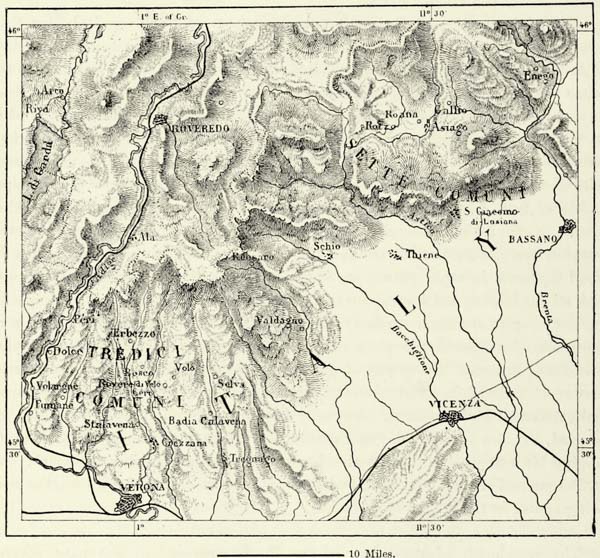
Family and topographical names of Lombard origin are very common on the left bank of the Po, and as far as the foot of the Apeninnes. Marengo, for instance, is a corruption of the German Mehring.
This German influence upon manners and language has been most enduring in the Friuil, or Furlanei, a district bounded by the Adriatic, the Carniolan Alps, and the plateau of the Karst, or Carso. The Friulians were even looked upon as a distinct race, though their ancestors, like those of most Italians of the north, were Latinised Celts. Frequent intermarriages with their Slovenian neighbours {217} contributed in some measure to produce a type distinct from that of Venice or Treviso. The number of these Friulians still speaking their own dialect does not now exceed 50,000 souls.
Fig. 71.—MONTE ROSA, AS SEEN FROM GALCORO.
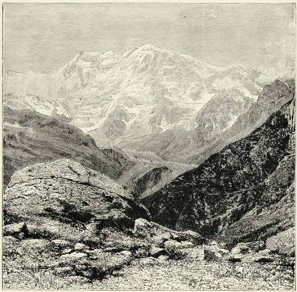
Amongst the numerous German colonies of which traces have been found in the plains of Northern Italy and on the southern slopes of the Alps, the “Thirteen Communes” to the north of Verona, and the “Seven Communes” in the deep valleys to the north-west of Bassano, are the most considerable. The homines Teutonici of these two districts are supposed to be the descendants of the Cimbrians defeated by Marius, and blue eyes and fair hair still prevail amongst them, but in all other respects they resemble the Italians of the plains, and only a few old women amongst them still talk the language of their ancestors, which is said to resemble the dialect spoken on the Tegern Lake, in Bavaria. Nor were they the champions of German authority on Italian soil. On the contrary, they were charged by the Republic of Venice with the defence of the northern frontier, and {218} have always valiantly acquitted themselves of this duty. In return, they were granted self-government and exemption from military service. But neither the Republic of Venice nor Austria was able to protect these German colonies against an invasion of the “Welsh” or Italian element, and there do not now exist any non-Italian communities to the east of the great lakes. To the north of Piemont, however, in the valleys descending from Monte Rosa and in the valley of Pommat, where the Toce forms one of the most beautiful waterfalls, German colonies still maintain their ground. They, too, would long ago have lost their language were it not for the support they receive from the Germans occupying the Swiss valleys on the northern slopes of the Alps. Alagna, or Olen, one of these German villages, preserved its ancient customs until quite recently. For centuries there had been no lawsuit there; contracts, testaments, and other legal documents were unknown; and everything was regulated by “custom;” that is, by the absolute authority of the heads of families.
The French element is far more numerous on the Italian slope of the Alps than the German. The inhabitants of the valley of Aosta, between the Grand Paradis and the Monte Rosa, of the upper valleys of the Dora Riparia, Cluson, Pelice, and Varaita, speak French, and are of the same origin as the Savoyards and Dauphinois on the western slope of the Alps. The configuration of the ground has facilitated this pacific invasion of the western Celts, numbering about 120,000 souls. They descended from the passes, and occupied the whole of the forest and pastoral region down to the foot of the hills, the last mountain defile, in many instances, forming their boundary. But the French language is steadily losing ground, for the official language is Italian, and every village has already two names, of which the modern Italian one is used by preference. The Vaudois, or Waldenses, in the valleys of Pelice (Pellis) and Cluson, above Pinerolo (Pignerol), alone resist this Italianisation with a certain amount of success, for they have a literature and history, and are held together by strong religious ties. Their sect was persecuted as early as the thirteenth century, long before the Reformation, and ever since, until their final emancipation in 1848, they have struggled against adversity. Many times it was thought they had been exterminated, but they always rose again, and in history they occupy a rank far out of proportion to their small numbers.
The bulk of the population are engaged in agriculture, which need not be wondered at if we bear in mind the fertility of the soil, the abundant supply of water, and the improvements effected in bygone ages. The labour invested in every kind of agricultural improvement, such as canals, embankments, terraces, or ronchi, built up like steps on the slope of every hill, has been immense, and defies computation. The mode of cultivation, moreover, entails a vast amount of labour, for the peasant knows not the iron plough, but tills his field with the spade: he is a gardener rather than an agriculturist. The agricultural produce is immense; its annual value is estimated at £80,000,000 sterling, and it furnishes large quantities for exportation. Cereals, forage, mulberry leaves and cocoons, vegetables and fruit, and cheese, including the famous Parmesan, are the principal products. {219} Lombardy and Piemont occupy the first rank in the world for certain kinds of agricultural produce, and they are almost the only countries in Europe in which rice, introduced in the beginning of the sixteenth century, is extensively grown. The vineyards, on the other hand, are not as carefully tended as they might be, and the wines, with the exception of those of Asti, Monferrato, San Colombano, and Udine (the picolito), are of small repute.
The valley of the Po divides itself into several well-marked agricultural provinces. In the Alpine valleys, between Col di Tenda and Monte Tricorno, the greater portion of the forests and pastures is held in common, but nearly every mountaineer is likewise the free proprietor of a bit of meadow or land, which his labour has converted into a garden. The social condition of these mountaineers thus resembles that of the French peasantry; for they, likewise, enjoy the advantages of a minute division of the land amongst freehold proprietors. The hilly tracts along the foot of the mountains are divided into farms of moderate size. The peasant no longer owns the land, but, in accordance with old feudal customs, he shares in its produce. In the plain, where it is necessary to keep up a complicated system of canals, nearly all the land belongs to rich capitalists, who cut it up into numerous small farms, and for the most part reside in the towns. These small farmers have no resources of their own, and are hardly above the rank of agricultural labourers. Though they cultivate the most fertile region of Northern Italy, they are miserably fed, frequently decimated by disease, and least alive to the advantages of education. The contrast between these miserable peasants and the mountaineers of Vaudois and the Val Tellina is great indeed.
Periodically many of the mountaineers migrate to the towns and neighbouring countries in search of work, and a proverb tells us that there is no country in the world “without sparrows or Bergamosks.” But though the natives of the hills of Bergamo furnish a numerous contingent of these migrants, they are outnumbered by Friulians, inhabitants of the shores of the Lago Maggiore, and Piemontese. The latter cross the passes of the Western Alps in large numbers in search of work at Marseilles and other towns of Southern France, and, small wages sufficing for their frugal wants, they are not particularly liked by their French fellow-workmen.
The metallic wealth of Northern Italy is but small. The only mines of note are those which formerly supplied the famous armourers of Brescia with iron, and the gold diggings of Anzasca, at the foot of Monte Rosa, where 5,000 slaves were kept at work by the Romans, and which are not yet quite exhausted. Marble, gneiss, granite, potters’ clay, and kaolin are, however, found abundantly. In former times silks, velvets, carpets, glass, porcelain, metal-work, and other art productions of the workmen of Venice and Lombardy enjoyed a very high reputation. These ancient industries decayed with the downfall of the old republics, but there are signs now of their revival. The want of coal or other fuel for setting in motion the machinery of modern factories is compensated for, to some extent, by an abundant water power, and this explains why nearly all the important manufactories are met with at the debouchures of the Alpine valleys. {220}
Μ
Fig. 72.—THE LAGOONS OF COMACCHIO.
Scale 1 : 290,000.
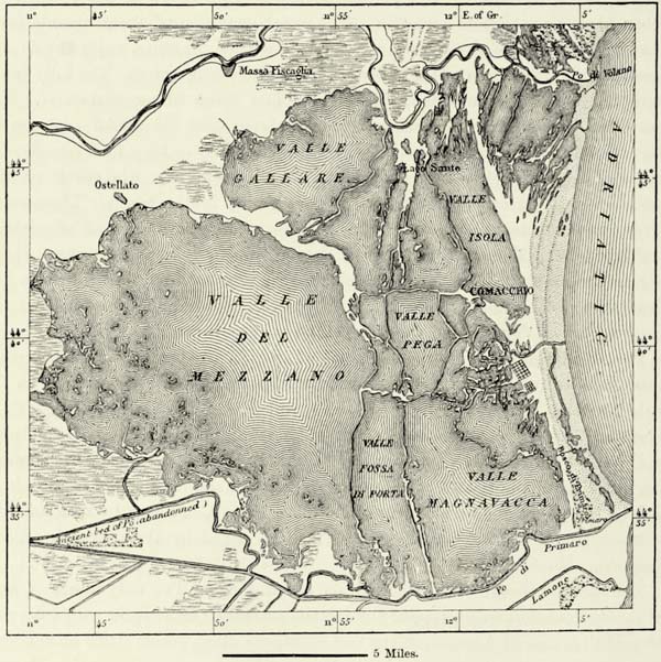
Amongst the ancient industries of the country not yet extinct, the fisheries of the lagoons of Comacchio occupy a foremost place. The Canal of Magnavacca, now hardly navigable, admits the waters of the sea into the Canal Palotta, which may be described as the great artery of these lagoons. It was constructed in 1631–34, and, by an ingeniously designed system of ramifying canals, carries the vivifying floods to the most remote parts of the lagoons. The various basins, or valli, of the lagoons are thus filled with sea-water, and constitute as many breeding beds, where the fish come from the sea multiply abundantly. A labyrinth of canals provided with flood-gates cuts off their retreat to the sea, and they are caught in immense numbers when the fishing season arrives. Spallanzani has seen 60,000 pounds of fish taken in a single bed, or valle, within an hour; but sometimes the draught is even more considerable, and the fish are actually used as manure. The fishing population of Comacchio numbers about 5,000 individuals, most of them distinguished by tall stature, great strength, and suppleness. Coste, the fish-breeder, mentions it as a curious fact that this secluded colony of fishermen {221} should have retained these characteristic features for centuries, though sustained exclusively by fishing, and living upon mullets, eels, and acquadelle. Unfortunately these fishermen are not the proprietors of the ponds, for they belong to the State or to rich private individuals. The workmen live in large barracks away from the town, to which they return only at stated intervals, and even their wives and relatives are not permitted to visit them in their places of exile.
Μ
Fig. 73.—THE FISHERIES OF COMACCHIO.
Scale 1 : 78,000.
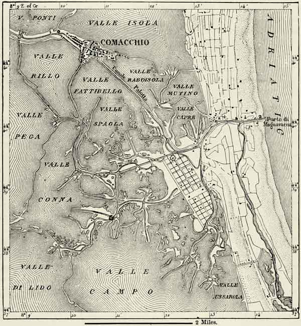
The enormous population of the valley of the Po, which almost equals that of the remainder of continental Italy, is very unequally distributed; but, except in the high and cold Alpine valleys, the inhabitants live in towns, dozens of which may be seen peeping out amidst the verdure if we ascend a high tower. There are scarcely any villages or hamlets. The farmers alone live in the country, completely isolated from each other, whilst the numerous landed proprietors throng the towns, and impart to them an aspect of wealth which similar places in other {222} parts of Europe cannot boast of. No other country in the world is as densely populated, and in Lombardy the number of towns is relatively larger than anywhere else.70
Large towns, too, are numerous, and many of them enjoy a deserved reputation amongst the cities of the world on account of their monuments, art treasures, and historical associations. Their number is partly accounted for by the density of the population, and by the facility with which the inhabitants were able to shift their abodes, according to the hazards of war or the vicissitudes of events. And this accounts, too, for the large number of towns which became famous as the capitals of republics, or as royal and ducal residences.
Several of the towns at the base of the Alps occupy sites marked out for them by nature. Such are the towns at the mouth of the valleys or defiles, which were places of defence as well as staples of commerce. Ariminum, the modern Rimini, at the southern extremity of the great plain of the Po, was one of these, for during the reign of the Roman it defended the narrow littoral passage between the Adriatic and the Apennines. The Flaminian Road there reached the sea, the Emilian Road thence departed for the north-west, as did also the littoral road of Ravenna. When Rome had ceased to be the capital of the world, and Italy was divided into small hostile states, the towns in the southern part of the plain, or near the passes over the Po, such as Ferrara and Bologna, retained their strategical importance. Piacenza, which defends the passage of the Po between Piemont and Emilia, remains a first-rate fortress to the present day; Alessandria, near the confluence of Tanaro and Bormida, and in a plain famous for many a bloody battle, was likewise destined to become a formidable fortress, though derisively called a “city of straw.” Every valley debouching from France or Austria was locked at its mouth by a strong fort; but most of these places, such as Vinadio, Pinerolo, Fenestrella, and Susa, have become untenable, owing to the range of modern artillery.
The defences of the road over the Brenner, ever since the downfall of the Roman empire, had to be looked to most carefully, for the plain between the Mincio and the Adige, to the south of the Lake of Garda, is the least-protected part of Italy from a military point of view. History has proved this. Well might the peaceable inhabitants of the plain consecrate this Alpine road to the gods, and intrust its defence to the neighbouring tribes. But the northern barbarians were not to be stopped by altars; and many a time they swept down it like an avalanche, pillaging the towns and massacring the inhabitants. No spot on the earth’s surface has been so frequently saturated with human blood. Most of the battles for the possession of Italy, down to our own days, were fought near the mouth of the upper valley of the Adige. Hardly a town or a village of this small district but {223} has gained a mournful notoriety in the dark pages of human history. It is there we must seek for the battle-fields of Castiglione, Lonato, Rivoli, Solferino, and Custozza. When the Austrians held Lombardy and Venice, they took care to protect this district by the four fortresses known as the Quadrilateral (Verona, Peschiera, Mantua, and Legnago) and other works. These constituted the “key of the house,” of which Italy has now repossessed herself.
Μ
Fig. 74.—MOUTH OF THE ADIGE VALLEY.
From the Austrian Staff Map. Scale 1 : 397,000.
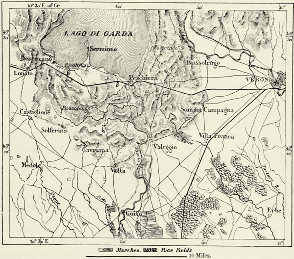
The configuration of the country which rendered these defiles of the Alps of importance strategically, likewise insured their commercial importance. The fortresses were placed there to defend the passes, the commercial entrepôts to intercept the trade. The rank of these places of commerce depends essentially upon the number and the importance of the roads which converge upon them. Turin, upon which converge all the Alpine roads from Mont Blanc to the Apennines, naturally became one of the vital points of European commerce. Milan, to which lead the seven great Alpine routes of the Simplon, the Gotthard, the Bernardino, the Splügen, the Julier, the Maloya, and the Stelvio, was marked out by nature as a commercial emporium. Bologna, too, which was separated by the swamps of the Po from the Alpine passes, has risen into importance since railways have joined it to Vienna, Paris, Marseilles, and Naples. {224}
The valley of the Po would never have attained its importance in the history of Europe unless roads had been constructed for traversing the obstructive mountains which surround it on all sides except towards the east, where it opens out upon the Adriatic. No other district of Europe is so completely hemmed in by natural obstacles as is this, but the construction of carriage roads and railways has converted Northern Italy into one of the great centres of European commerce. Venice gives it the command of the Adriatic, the Apennine railways connect it with Genoa, Savona, the Gulf of Spezia, and the Tyrrhenian, and it thus commands the two seas which wash the shores of Italy. Other railways cross the Alps, and put it into communication with France and Germany. This central position, joined to the natural fertility of the country, has converted Northern Italy into one of the most flourishing portions of Europe. Human hands have conquered original geographical disadvantages, and the true centre of Italy is in the ancient Cisalpine Gaul, and not at Rome. Had the Italians been guided in the choice of their capital by actual importance, and not by historical tradition, they would have chosen one of the great cities of their northern plain.
Μ
Fig. 75.—THE PASSAGES OVER THE ALPS.
Scale 1 : 6,000,000.
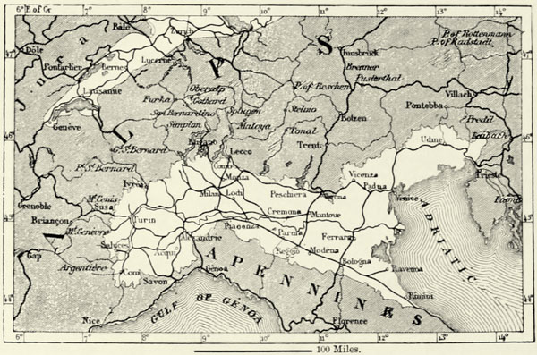
Turin, though an old town, seeing that it was burnt by Hannibal, is nevertheless a modern city, if we compare it with other towns of Italy. Its straight and broad streets almost give it the appearance of a town of the New World. Until made a ducal residence, Turin was but a small provincial town. During the time of the Romans, and even during the Middle Ages, the great high-road between Italy and Gaul led along the coast of the Gulf of Genoa. The passage of the Alps was looked upon with dread by travellers. Still some traffic went on even in these {225} early days, and small towns sprang into existence at the foot of each Alpine pass. Amongst these were Mondovi, the triple town built on three hills; Cuneo, favourably placed upon a terrace between Stura and Gesso, in which rise the hot sulphur springs of Valdiera; Saluzzo, on the gentle slope of the foot-hills of Monte Viso; Pinerolo, with its ancient castle, so often converted into a prison of state; Susa, the Italian key of Mont Cenis; Aosta, still abounding in Roman antiquities; Ivrea, built on a site formerly occupied by a glacier descending from Monte Rosa; and Riella, with its flourishing woollen industry. The towns lower down in the plain, upon which several of these Alpine roads converged, likewise attained some local importance. In Upper Piemont there are Fossano, on a heap of shingle at the junction of the roads of Mondovi and Cuneo; Savigliano, lower down, where the roads of the Po and Maira valleys join; and Carmagnola, which commands one of the principal roads over the Apennines. Novara, the commercial outlet of the Lago Maggiore, and in the midst of one of the most productive agricultural districts, is the most populous town of Eastern Piemont. Vercelli, on the Sesia, and below the confluence of the rivulets descending from Monte Rosa, enjoys natural advantages similar to those of Novara. Casale, the ancient capital of Monferrato, defends one of the principal passages of the Po.
But Turin, owing to its favourable position, has become the great emporium of the valley of the Upper Po. Its commerce has grown immensely, since the town no longer enjoys the perilous honour of being the capital of a kingdom, and the places vacated by the court and Government officials have been filled up quickly by immigrants carried thither by the railways. Its libraries, a fine museum, and various learned societies entitle it to rank as one of the intellectual centres of the peninsula, whilst its manufactures of silks and woollens, of paper and other articles, are of great importance. The environs of Turin are delightful. From the hill of the Superga, a few miles to the east of the city, and crowned by a sumptuous church, may be enjoyed one of the finest panoramas of the Italian Alps. The numerous small towns in its vicinity, such as Moncalieri, Chieri, and Carignano, abound in villas and participate in the prosperity of the capital. As to the towns in the valley of the Tanaro, in the south, they form a group apart, and are the natural intermediaries between the valley of the Po and the port of Genoa. Alessandria, a strong fortress of hideous regularity, which has superseded the old fortresses of Tortona and Novi, is the terminus of eight railways, and one of the busiest places of Italy. The neighbouring cities of Asti, famous for its sparkling wines, and Acqui, celebrated from the time of the Romans for its hot springs, are likewise important for their commerce.71