SPAIN.* (continued 2)
Reading edition
Málaga, like most of the ports on that coast, is of Phœnician origin, and the most populous town of Andalusia. Less rich than Granada, Córdova, and Seville in Moorish monuments, or than Cádiz in historical traditions, it is indebted to its port and to the fertile country surrounding it for its commercial pre-eminence. Its exports, consisting of raisins (pasas), almonds, figs, lemons, oranges, wine, olive oil, &c., are the product of the immediate vicinity. There are foundries, sugar refineries, and factories. Seen from the sea, the cathedral appears to be almost as large as the rest of the town, but in the latter must be included not only the houses standing at the foot of the citadel of Gibralfaro, but also the numerous villas dotting the surrounding hills. Nay, even the picturesque towns and watering-places in the neighbouring mountains, such as Alora, Alhaurin, Carratraca, and Alhama, may be looked upon as dependencies of the city, for scarcely any but Malagueños resort to them.
Μ
Fig. 157.—GIBRALTAR.
Scale 1 : 150,000.
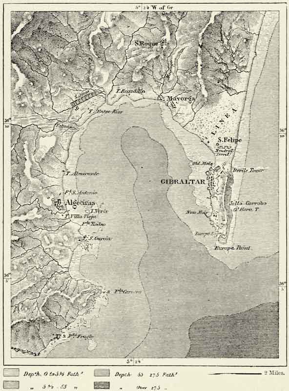
Antequera and Ronda, in the interior of the country, belong to the basin of the Mediterranean, for the one stands on the Guadalhorce, which enters the sea near Málaga, whilst the other occupies a position in the upper basin of the Guadiaro, which washes the foot of the hills of San Roque, to the north of Gibraltar. Antequera is one of the most ancient towns of Spain, and acts as an intermediary between Málaga and the valley of the Guadalquivir. On a hill near it stands a curious dolmen, twenty feet in height, known as Cueva del Mengal. {413} The picturesque Moorish town of Ronda is surrounded on three sides by a gorge 600 feet in depth, 120 to 300 feet wide, and spanned by three bridges, one Roman, one Arab, and the last (built 1740–88) Spanish. Ronda still possesses some strategical importance, for it defends the road leading from the valley of the Genil to that of the Guadiaro. The Rondeños are noted for the skill with which they train horses for mountain travel. They are notorious smugglers, as are also many {414} of the inhabitants of the small seaport towns of Marbella, Estepona, and Algeciras, near Gibraltar.146
The rock of Gibraltar, of which the English obtained possession in 1704, has not only been converted into a first-rate fortress, but is likewise a busy place of commerce. Gibraltar produces nothing except a little fruit, and most of its provisions, including meat and corn, are imported from Tangiers, in Morocco. The inhabitants of the town are dependent for their support upon passing vessels, the English garrison, and a brisk contraband trade with Spain. Gibraltar affords very indifferent shelter, and only one-fourth of the vessels passing through the strait call there, and even these generally confine themselves to replenishing their stock of coal. Nor is a residence on this picturesque rock very pleasurable, for fevers prevail, and the military character of the place entails numerous restrictions. During the heat of summer many of the English residents—facetiously called “lizards of the rock”—seek refuge at San Roque, a village to the north of the bay, the neighbourhood of which affords excellent sport.147
IV.—THE MEDITERRANEAN SLOPE OF THE GREAT PLATEAU. MURCIA AND VALENCIA.*
In a few hours we are able to travel from the inhospitable plateaux to the hot valleys and plains of Murcia and Valencia debouching upon the Mediterranean.
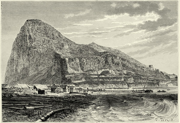
GIBRALTAR, AS SEEN FROM THE “LINES.”
The spurs from the Sierra Nevada, which approach the coast to the north of the Cabo de Gata, are separated by ramblas, or torrent beds, and gradually decrease in height as we proceed north. The torrent of Almanzora separates the Sierra de los Filabros from its northern continuation, the Sierra de Almenara, which for a considerable distance runs parallel with the coast. It sends out a spur in the direction of Cartagena, which terminates in Cabo de Palos. The inland ranges run almost parallel with this coast range, and are separated by longitudinal valleys opening out into the great transverse one of the Segura. These ranges are the Sierra de María, “el Gigante” (4,918 feet), with the Sierra de Espuña (5,190 feet), the Sierra de Taibilla, the Calar del Mundo (5,440 feet), and the Sierra de Alcaraz {415} (5,910 feet). The ranges to the north and east of the Segura must be looked upon as continuations of those mentioned. They attain their greatest altitude in the Moncabrer (4,543 feet), and their spurs form several notable promontories, amongst which are the volcanic Peñon de Ifach and the Cabos de la Nao and San António. Near the latter rises the Mongo (2,337 feet), which has become known as a crucial trigonometrical station.
The mountains which dominate the valley of the Júcar present the feature of a denuded plateau, above which rise a few isolated summits. The aspect of the basin of the Guadalaviar is far more mountainous. On the west it is bounded by the sierras having their nucleus in the Muela de San Juan (5,280 feet), and to the east rise the imposing mountain masses of the Javalambre (6,569 feet) and Peña Golosa (5,942 feet). The summits of the range which extends from the latter to the great bend of the Lower Ebro, such as the Muela de Ares (4,332 feet), the Tosal de Encanades (4,565 feet), and Bosch de la Espina (3,868 feet), bear Catalan names. A range of inferior heights runs parallel with it along the coast, the interval between the two forming a strath, or vale. This coast range terminates abruptly in the Sierra de Montsia (2,500 feet), close to the delta of the Ebro, and before the pent-up waters of the river had excavated themselves a path to the sea it extended right to the Pyrenees.
All these mountains are for the most part naked, and shrubs appear like black patches upon their whitish slopes. They stand out clearly against the blue and limpid sky, whose transparency has won Murcia the title of the “most serene kingdom.” The climate in the valley of the Segura is even more African in its character than that of Andalusia. There are only two seasons, summer and winter, the latter lasting from October to January, but the temperature throughout the year is equable, owing to the mistral which blows from the cool plateau and the sea breezes.
The flora, especially along the coast of Murcia, is a mixture of tropical and temperate plants. There are trees which shed their leaves in winter, others which retain their foliage throughout the year, and by the side of wheat, rice, maize, olives, oranges, and grapes are grown cotton, sugar-cane, sweet potatoes, nopals, agaves, and dates. Tropical diseases have found a congenial soil in this country. Yellow fever has been imported occasionally from America. The putrefying substances left upon the fields after floods poison the air, and the brackish waters of the lagoons, or albuferas, are the breeding-places of fever. The salt lakes to the south of the Segura, however, exercise no deleterious influence upon the climate.
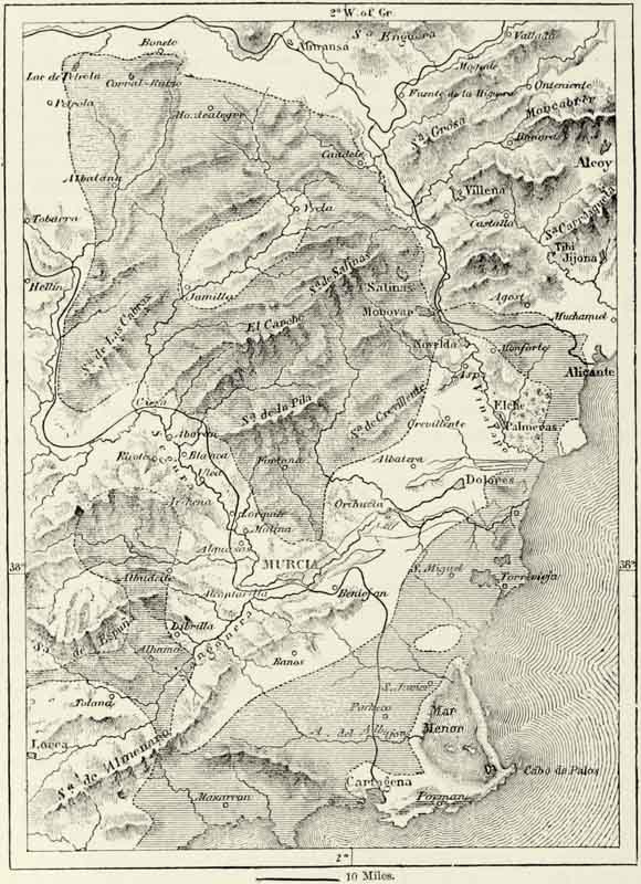
Nowhere else in Spain is the rainfall so inconsiderable. Between Almería and Cartagena only eight inches fall during the year; in the environs of Alicante and Elche the rains are, perhaps, a trifle more copious; and at Murcia and Valencia, which lie at the foot of mountains that intercept the moisture-laden winds, they are more abundant still, though even there they do not exceed eighteen inches. Moreover, most of the rain is immediately absorbed by the thirsty air, and only a very small quantity finds its way through ramblas to the sea. The quantity is altogether insufficient for agricultural purposes, and if it were not for the rivers the {416} country would be a desert. Cultivation is carried on only along the rivers and in a few other favoured spots. Veritable steppes extend on both banks of the Segura. The campos between Almería and Villajoyosa, for a distance of 300 miles, are sterile and bare. The brine and magnesia springs, which rise at the foot of the saliferous triassic rocks, fill small lakes, which dry up in summer, and in August the lagoons near Orihuela become covered with a thick crust of salt.
Μ
Fig. 158.—STEPPES OF MURCIA.
Scale 1 : 992,000.
{417}
The beneficent rivers, whose waters are drunk by the huertas, or gardens, near their banks, are the Segura, Vinalapo, Júcar, Guadalaviar (known as Turia in its lower course), Mijaros, and several others. They all resemble each other as regards the ruggedness of their upper valleys and the savageness of the gorges through which they pass. The Segura forces itself a passage through several mountain defiles before it reaches the plain of Murcia. The Júcar and Guadalaviar (Wad-el-Abiad, or “white river”) have fewer obstacles to overcome, but some of the gorges through which they pass are nevertheless of surpassing beauty.
The volume of these rivers is comparatively small, and the husbandmen dwelling along their banks economize the water as far as possible. Reservoirs, or pantanos, have been constructed at the outlet of each valley, whence the water is distributed over the fields by means of innumerable canals of irrigation. The irrigated huertas contrast most favourably with the cultivated campos in their neighbourhood. Irrigation has probably been practised at Valencia since the time of the Romans, but the Moors appear to have been the first to construct a regular system of canals. Eight of these, ramifying into innumerable acequias, have converted the environs of Valencia into an Eden. Carefully manured as they are, these fields are never allowed to lie fallow. Stalks of maize fifteen and even twenty-five feet in height may be seen in the gardens, the mulberry-tree yields three or four harvests annually, four or five crops are obtained from the same field, whilst the grass is mown as many as nine or ten times. This luxuriant vegetation, however, is said to be watery, and hence the proverb, “In Valencia meat is grass, grass is water, men are women, and women nought.”
The huertas of the Júcar, though less famous than those of Valencia, are even more productive. Orange-trees predominate, and around Alcira and Carcagente alone 20,000,000 oranges are picked annually, and exported to Marseilles.
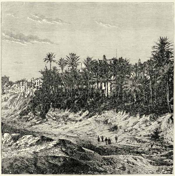
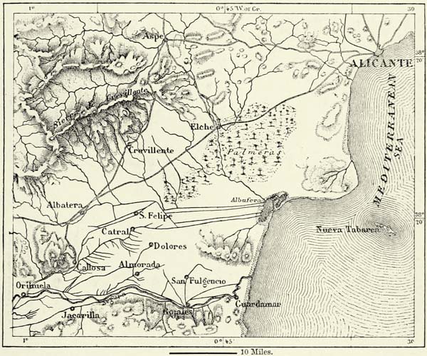
The oases in the great steppe which extends from Alcoy to Almería are less fertile than those on the Júcar and Guadalaviar. That of Alicante is fertilised by the Castalla, the waters of which are collected in the reservoir of Tibi. The huerta of Elche, on the Vinalapo, is chiefly occupied by a forest of palm-trees, the principal wealth of the inhabitants, who export the dates to France, and the leaves to Italy and the interior of Spain.
The huerta around Orihuela, on the Lower Segura, cannot boast of a palm forest like that of Elche, but is more productive. The inhabitants of Murcia, higher up on the same river, though they enjoy similar advantages, have failed to profit by them to the same extent. Their huerta, which contains a third of the total population of the province, is fertile, but cannot compare with that of their neighbours. Nor do the fields of Lorca equal them. They have not yet recovered from the bursting of a reservoir, the freed waters of which carried destruction as far as Murcia and Orihuela.
The moral and physical character of the inhabitants of a country exhibiting such great contrasts could hardly fail to present corresponding differences, and, indeed, we find that the inhabitants of the fertile gardens and those of the barren steppes and mountains differ essentially, in spite of their common origin. {418}
Fig. 159.—THE PALM GROVE OF ELCHE.
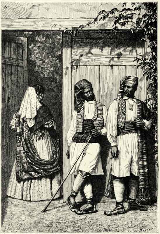
PEASANTS OF LA HUERTA, AND CIGARRERA OF VALENCIA.
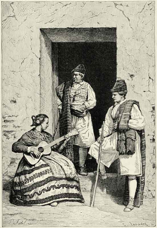
The people of Murcia cannot be said to have issued victoriously from the struggle against barren rocks, desiccating winds, and a dry atmosphere. They abandon themselves to a fatalism quite oriental, and make hardly any effort at improvement. Lazily inclined, they take their siesta in and out of time, and even when awake preserve an aspect of impassiveness as if they pursued a reverie. They are not much given to gaiety, and, though neighbours of Andalusia and La Mancha, do not dance. They are full of rancour and savage hatred when offended, and have exercised but small influence upon the destinies of Spain. They cannot compare in industry with Catalans, Navarrese, and Galicians, nor in intelligence with natives of any other part of Spain. The Valencians, on the other hand, are an industrious race. They not only cultivate their plains, but scale the barren slopes of the rocks with their terraced gardens. They are a gay people, famous for their dances. Ferocious instincts are asserted to underlie this outward gaiety, and a proverb says that “the paradise of La Huerta is inhabited by demons.” Human life is held very {419} cheaply in Valencia. Formerly that town supplied the courtiers of Madrid with hired assassins, and the numerous crosses in and around it are evidence of so many murders committed in the heat of passion. In Valencia, however, the use of the knife is a tradition of chivalry, as are duels in some other parts of Europe. The conscience of the murderer is perfectly at ease; he wipes the blood-stained knife upon his girdle, and immediately afterwards cuts his bread with it. The dress of the Valencians consists of loose drawers confined round the waist by a red or violet scarf, velvet waistcoats with pieces of silver, white linen gaiters leaving the knees and ankles bare, a bright kerchief wrapped round the shaved head, and a low hat with brim turned up and ornamented with ribbons. A many-coloured cloak with a broad fringe completes this costume, and, draped in it, even the meanest beggar possesses an air of distinction. In their customs and modes of thought the Valencians differ equally from their neighbours. They speak a Provençal dialect, mixed with many Arabic words, but more closely related to the language of the troubadours than the dialect of the Catalans.
Μ
Fig. 160.—THE PALM GROVE OF ELCHE AND THE HUERTAS OF ORIHUELA.
Scale 1 : 400,000.
Agriculture is the leading pursuit of Valencia and Murcia, and a few branches of industry are carried on. Many hands are occupied in making the white wines of Alicante and the red ones of Vinaroz and Benicarló; the grapes of the vineyards of Denia, Javea, and Gandia, to the north of Cabo de la Nao, are converted {420} by a complicated process into raisins; and the esparto grass growing abundantly on the sunny slopes of Albacete and Murcia is employed in the manufacture of mats, baskets, sandals, and a variety of other objects.149 There are hundreds of metalliferous lodes, but only the lead mines in the hills of Herrerías, to the east of Cartagena, are being worked on a large scale, and that by foreigners. Zinc has been worked since 1861, and mines of copper, lead, silver, mercury, and rock-salt abound at some distance from the coast; but, from want of means of communication, their exploitation would not pay.
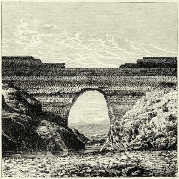
Fig. 161.—RUINS OF THE DYKE OF THE RESERVOIR ABOVE LORCA.
Valencia is the more industrial province of the two. Albacete manufactures the dreaded navajas, or long knives; Murcia has silk-mills; Cartagena rope-walks and other establishments connected with shipping; Játiva has a few paper-mills; but Valencia and Alcoy are now the great centres of industry. The former {421} manufactures the plaids worn by the peasantry, silks and linens, earthenware and glazed tiles. Alcoy supplies most of the paper for making Spanish cigarettes.
Fig. 162.—PEASANTS OF MURCIA.
{422}
The towns of Albacete and Almansa are important, as lying on the great high-road which connects the plateau of La Mancha with the Mediterranean seaboard. But they cannot vie in wealth and population with the towns situated on the coast, or within twenty-five miles of it. Lorca, the southernmost of these towns, lies picturesquely on the slopes and at the foot of a hill crowned by a Moorish citadel. The old town, with narrow tortuous streets and the remains of Arab palaces, has been given up to Gitanos, and a new town with wide and straight streets built in the fertile plain irrigated by the Guadalentin. A fine road joins Lorca to the small harbour of Aguilas, twenty miles to the south.
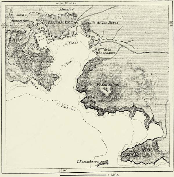
In descending the valley of the Guadalentin we pass Totana, the head-quarters of the Gitanos of the country, and Alhama, well known on account of its hot springs, and finally enter the mulberry and orange groves which surround the capital of the province. Murcia, though an extensive city, hardly looks like it, for its streets are deserted, its houses without beauty, and the only objects of interest are the cathedral, the shady walks along the banks of the Segura, and the canals irrigating the terrace gardens. Far more interesting is the neighbouring Cartagena, which was destined by its Punic founders to become a second Carthage in truth, and its magnificent harbour certainly affords great advantages for commercial and military purposes. The discovery of the rich lead and silver mines near the town contributed much towards its prosperity. Successive Spanish Governments have attempted to restore to Cartagena its ancient strategical importance. They have constructed docks and arsenals, and erected impregnable fortifications, but, in spite of this, the population of the town is hardly a third of what it was in the middle of the eighteenth century. The character of its commerce is almost local, notwithstanding its excellent port, and esparto grass, mats, fruits, and ore constitute the leading articles of export.
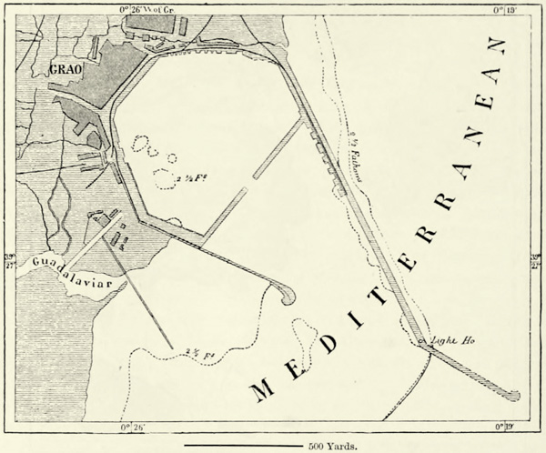
Alicante, though far less favoured by nature, is a much busier place, thanks to the fertility of the huertas of Elche, Orihuela, and Alcoy, and the railway which connects it with Madrid. Only small vessels can approach the quays and piers of the town, nestling at the foot of a steep rock crowned by a dismantled citadel. Larger vessels are compelled to anchor in an open roadstead. Other coast towns of Valencia, such as Denia and Cullera, offer still less shelter, but are nevertheless much frequented by coasting vessels. Formerly vessels which entered the Bay of Valencia during winter were bound to exercise the greatest caution, owing to violent easterly and north-north-easterly winds and fogs, for there existed not a single port of refuge. This want has now been supplied by the construction of a port at the mouth of the Guadalaviar, known as El Grao (strand) de Valencia.
Valencia, the fourth city of Spain in population, is the natural centre of the most fertile huertas. The “City of the Cid” still preserves its crenellated walls, turrets, gates, narrow and tortuous streets, balconied houses, the windows of which are shaded by blinds, and awnings spread over the streets to protect passers-by from the rays of the sun. Amongst its numerous buildings there is but one which is really curious: this is the Lonja de Seda, or silk exchange, a graceful structure of the fifteenth century. Gardens constitute the real delight of Valencia, and {423} the Alameda, which extends along the banks of the Guadalaviar, is, perhaps, the finest city promenade in Europe. The commerce of Valencia rivals that of Cádiz.150
Μ
Fig. 163.—THE HARBOUR OF CARTAGENA.
Scale 1 : 54,000.
To the north of Valencia the cultivable country along the coast is narrow, and incapable of supporting large towns. Castellon de la Plana, at the mouth of the Mijaros, has attained a certain importance, but farther north we only meet with small places inhabited by fishermen and vine-growers. Formerly the coast road was defended by castles, chief among which was Saguntum, famous for its glorious defence against Hannibal. Its site is occupied by the modern town of Murviedro, i.e. “old walls,” and its ruins are not very imposing.151
V.—THE BALEARIC ISLANDS.
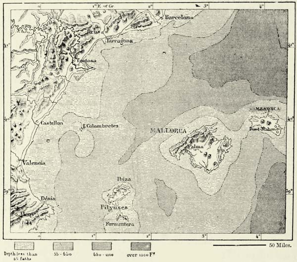
The Balearic Islands are attached to the mainland of Spain by a submarine {424} plateau, and are geographically as well as historically a dependency of Valencia and Catalonia. The ranges of hills traversing these islands have the same direction as those of Murcia and Valencia. On the other hand, the peninsula of La Baña, at the mouth of the Ebro, extends beneath the sea in the direction of Ibiza, and from this submarine tongue of land rises a group of volcanic rocks. These are the Columbretes, from the Latin colubraria, signifying “serpents’ islets.”
Μ
Fig. 164.—EL GRAO DE VALENCIA.
Scale 1 : 18,000.
The Baleares are small in area, but favoured by climate, productiveness, and natural beauty. They are the “Happy Islands” of the ancients, and, compared with many of the coast lands, are indeed a favoured region. War and pestilence have been no strangers to them, but continual troubles have not interfered with their development.
The islands consist of two groups, the Pityuses and the Baleares proper. The name of the latter is said to refer to the expertness of the natives as slingers; and, when Q. Metellus prepared to land upon them, he took care to shelter his men beneath an awning of hides. The climate is moister and more equable than that of neighbouring Spain. Violent storms occur frequently.
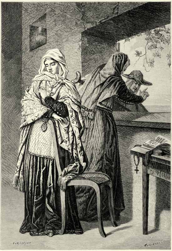
WOMEN OF IBIZA, BALEARIC ISLES.
The structures called talayots (watch-towers) prove that the islands were inhabited before the historic epoch. These were built probably by the same race to whom the nuraghi of Sardinia owe their existence; but the present population is a very mixed one, for every nation of antiquity has successively invaded the island. {425} The language spoken is a Catalan dialect resembling that of Limousin. The Majorcans are generally small of stature, but well proportioned, and the women of some of the districts are famed for their beauty and expressive features. The peasantry are suspicious and thrifty, but honest and hospitable; and their dress, consisting of loose breeches, a belt, a bright-coloured vest, and a goatskin cloak, is picturesque. Dancing to the music of a guitar or flute is their favourite amusement.
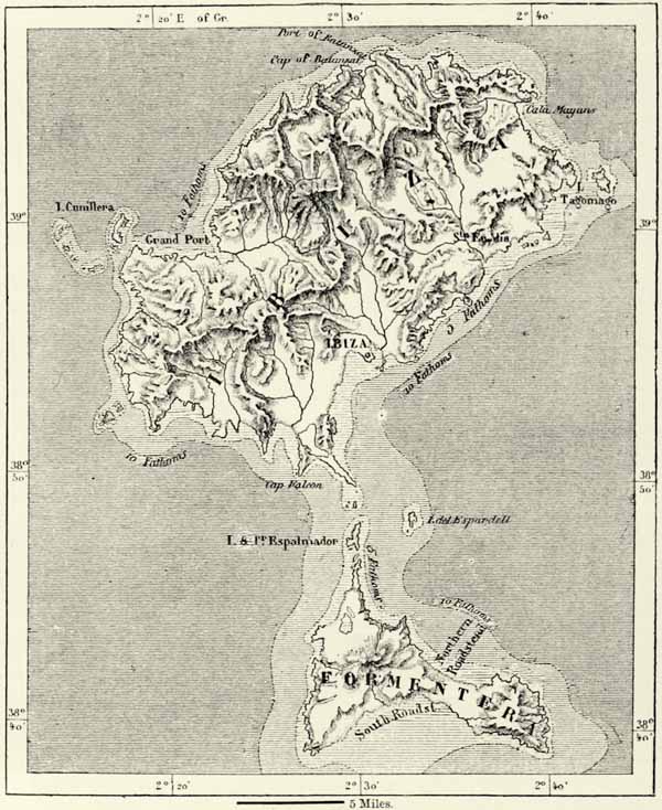
IBIZA (IVIZA), the largest island of the Pityuses, is hardly more than fifty miles from Cabo de la Nao. Its surface is hilly and intersected by numerous torrent beds. Puerto Magno (Pormany, or Grand Port) lies on the west side, and a similar bay, the trysting-place of numerous fishing-smacks, on the south side. On its shore stands the capital of the island, an ancient Carthaginian colony. A chain of islets and rocks, similar to the Adam’s Bridge of Ceylon, joins the southernmost cape of Ibiza to Formentera Island. The climate is said to be so salubrious that neither serpents nor other noxious reptiles can bear it. The population is small, in spite of the fertility of the island. Watch-towers and castles of refuge near every village recall the time when the inhabitants suffered from Moorish pirates. The islanders are happy, for the central Government leaves them pretty much to themselves.
MALLORCA, or MAJORCA, the largest of the group, is the only one which can boast of a regular range of mountains, rising precipitously along the north-western coast, and culminating in the twin peaks of Silla de Torrella (4,940 feet) and Puig Mayor (4,920 feet). These mountains are amongst the most picturesque in all Europe, and from their summits may be enjoyed a magnificent prospect. The moufflon is said still to haunt their pine woods and recesses. The greater portion of the island consists of a plain lying at an elevation of 150 feet above the sea-level, and dotted over with isolated puigs, or conical peaks, surmounted in many instances by an old church or castle. The eastern extremity of the island is hilly, and the Bec de Farruch (1,863 feet) still bears its old Arabic name. Near it are the wonderful stalactite caverns of Arta, which extend beneath the sea. The extremities of the most depressed portion of the island open out towards two great bays, one in the north-east, the other in the south-west. Palma, the capital of the island, lies on the former of these, though the other, known as Puerto de Alcudia, would offer greater advantages were it not for the pestilential swamps which surround it. On the iron-bound northern coast there are no harbours, but coasting vessels frequent the creek of Soller, whence they export oranges.
The peasants, or pageses, of Majorca have the reputation of being good agriculturists, but much of the progress made is due to Catalan immigrants. The island produces delicious wines (Benisalem), olive oil, oranges, vegetables, and pigs, all of which find a market at Barcelona or in France. The corn grown is not, however, sufficient for the support of the population, and Majorcans as well as “Mahonian” gardeners are met with in every town of the Mediterranean. Bay-salt is made at Cape Salinas. Shoes, cottons, linens, baskets, and porous vases are produced; but the manufacture of majolica has ceased. Palma is a busy place of 40,000 inhabitants, and its bastioned walls, castle, cathedral, and amphitheatrically built houses present a fine appearance from the sea. The inhabitants are proud of {426} their public buildings, and assert that their lonja is superior to that of Valencia. The Chuctas, or converted Jews, are a curious element of the population. They occupy a separate quarter, marry amongst themselves, and have preserved their race distinctions and mercantile genius. A large portion of the landed property of the island has passed into their hands. A railway traversing the rich districts of Santa María and Benisalem, to the south of the populous towns of Manacor and Felanitx, connects Palma with Alcudia.152
Μ
Fig. 165.—THE BALEARIC ISLANDS.
Scale 1 : 3,700,000.
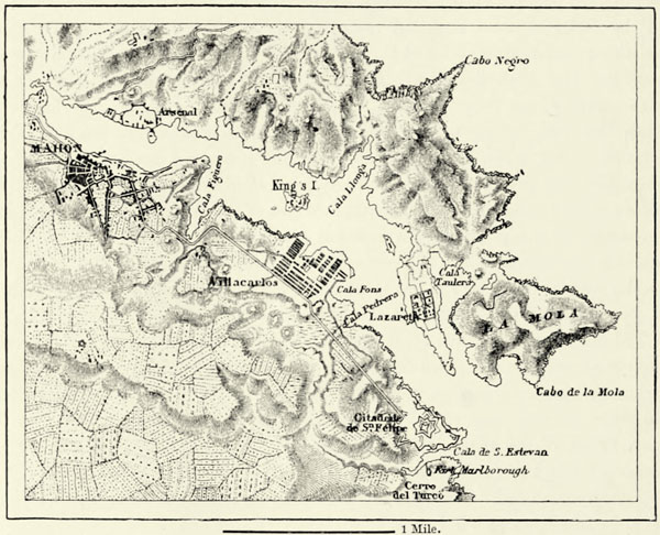
MENORCA, or MINORCA, twenty-four miles to the east of Majorca, is generally level, its culminating point, Monte Toro, in the centre of the island, only attaining a height of 1,171 feet. The strong northerly winds which sweep over its plains cause the trees to turn their branches in the direction of Africa, and orange-trees find shelter only in the barrancas, or ravines, which intersect them. The climate is less pleasant than that of the neighbouring island, and the soil less fertile, for, consisting for the most part of limestone, it rapidly absorbs the rain. There are two ports and two cities, one at each extremity of the island, which from time {427} immemorial have claimed precedence. Ciudadela (7,500 inhabitants) enjoys the advantage of closer proximity to Majorca, but its harbour is bad. Port Mahon (15,000 inhabitants), on the other hand, possesses an admirable port, and Andreas Doria says with reference to it that “June, July, and Mahon are the best ports of the Mediterranean.” The English made Mahon a wealthy city, but its trade fell off immediately when they abandoned it in 1802.
Fig. 166.—VIEW OF IBIZA.
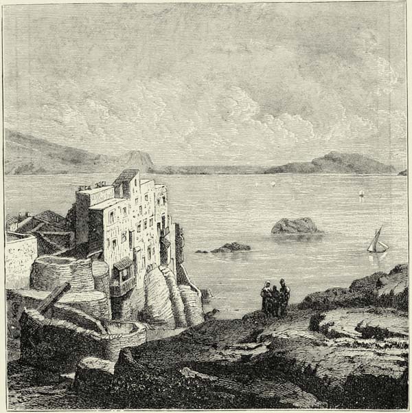
VI.—THE VALLEY OF THE EBRO. ARAGON AND CATALONIA.
The central portion of the valley of the Ebro is as distinctly separated from the remainder of Spain as is that of the Guadalquivir. It forms a vast depression, bounded by the midland plateau of Spain and the Pyrenees, and if the waters of the Mediterranean were to rise 1,000 feet, this ancient lake, which existed until its pent-up waters had forced themselves a passage through the mountains of {428} Catalonia, would be converted into a gulf of the sea. The Pyrenees in the north, the barren slopes of the plateaux to the south and south-west, form well-defined boundaries, but in the north-west the plain of the Ebro extends beyond Aragon, into a country inhabited by men of a different race.
Μ
Fig. 167.—THE PITYUSES.
Scale 1 : 400,000.
Historically and geographically, Aragon and Catalonia form one of the great natural divisions of Spain, less extensive than the Castiles, but hardly less important, and far more densely populated.153 The political destinies of Aragon and Catalonia have been the same for more than seven centuries, but, in spite of this, {429} there exist great contrasts, which have not been without their influence upon the character of the population. Aragon, a country of plains surrounded by mountains, is an inland province, and its inhabitants have remained for the most part herdsmen, agriculturists, and soldiers. Catalonia, on the other hand, possesses an admirable seaboard. Its natural wealth, joined to favourable geographical position, has developed commerce with neighbouring countries, and more especially with Roussillon and Languedoc. Indeed, seven or eight centuries ago, the Catalans were Provençals rather than Spaniards, and in their language and customs they were closely related to the people to the north of the Pyrenees.
In the course of the great political revolution, the most terrible feature of which was the war of the Albigenses, Catalonia became a prey to the Castilians. As long as the Provençal world maintained its natural centre between Arles and Toulouse, the populations of the Mediterranean coasts, as far as the Ebro, Valencia, and the Baleares, were attracted towards it as to their common focus. Those Christian populations who found themselves placed between Provence on the one hand and the Arab kingdoms on the other, naturally gravitated towards the former, with whom they possessed community of race, religion, and language. Hence the wide range of the idiom known as Limousin, and its flourishing literature. But when an implacable war had converted several towns of the Albigenses into deserts; when the barbarians of the North had destroyed the civilisation of the South, and the southern slopes of the Cévennes had been reduced by violence to the position of a political dependency of the valley of the Seine, Catalonia was forced to look elsewhere for natural allies. The centre of gravity was shifted from the north to the south, from Southern France to the peninsula of the Pyrenees, and Castile secured what Provence had lost.
The plateau to the south of the Ebro has been cut up, through the erosive action of rivers, into elongated sierras and isolated muelas (molars), and its edge is marked by numerous notches, through which these rivers debouch upon the plain. The Sierra de San Just (4,967 feet), now separated from that of Gúdar by the upper valley of the Guadalupe, is a remnant of this ancient plateau, as are the Sierras de Cucalon (4,284 feet), de Vicor, and de la Virgen, which join it to the superb mass of the Moncayo, in the north-west; and the same applies to the Sierra de Almenara (4,687 feet), which rises to the west of them.
The granitic mountain mass of the Moncayo (7,705 feet) has offered greater resistance to the erosive action of the waters than have the cretaceous rocks of the plateau to the east of it. The Moncayo is the storm-breeder of the plains of Aragon, and from its summit the Castilian can look down upon the wide valley of the Ebro. To the Aragonese the plateau is accessible only through the valleys of the Guadalupe, Martin, and Jiloca, and it is these which have enabled them to obtain possession of the upland of Teruel, which is of such strategical importance, from its commanding position between the basins of the Guadalaviar, Júcar, and Tajo.
To the north of the Ebro rises the snow-clad range of the Pyrenees, which separates Spain from the rest of Europe. Several spurs descend from this master range into Aragon. But there are also independent ranges, one of which, that of {430} the Bardenas, rises immediately to the north of the Ebro, right opposite to the gigantic Moncayo. The parallel ridges of the Castellar and of the “district of the Five Towns” form a continuation of these hillocks to the east of the Arba, and then, crossing the valley of the Gallego, we reach the barren terraces of the Monegros, upon which rises the insular Sierra de Alcubierra, in the very centre of the ancient lake of Aragon. A saddle, elevated only 1,247 feet above the sea-level, connects the latter with the mountains of Huesca in the north.
Μ
Fig. 168.—PORT MAHON.
Scale 1 : 50,000.
Several mountain masses of considerable height occupy the centre of the country, and separate these riverine hills from the main range of the Pyrenees. They consist for the most part of chalk, through which the bounteous rivers descending from the Pyrenees have excavated their beds. These channels, with their precipices, defiles, and cascades, form one of the most picturesque mountain districts of Spain. The most famous of these Pyrenean foot-hills is the Sierra de la Peña, which is separated from the Pyrenees by the deep valley of the Aragon. At the eastern extremity of this chain, high above the ancient city of Jaca, rises the pyramidal sandstone mass of the Peña de Oroel (5,804 feet), from which we are able to embrace an immense horizon, extending from the Pyrenees to the Moncayo. The wild district which occupies the centre of this magnificent panorama is the famous country of Sobrarbe, held in high veneration by patriotic Spaniards, for it was there they commenced their struggles against the Moors.
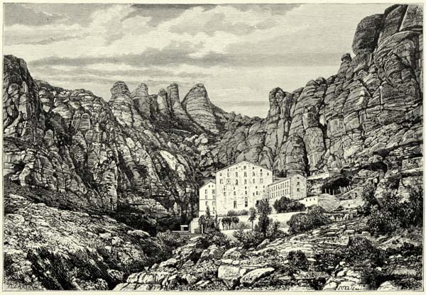
MONSERRAT, CATALONIA.
{431}
An elevated saddle connects the Sierra de la Peña with the irregular mountain mass of the Sierra de Santo Domingo, to the south of it, whose spurs descend in terraces into the rugged plain of the Five Towns. It is separated by a narrow cleft, through which passes the Gallego from the Sierra de Guara, which extends to the river Cinca in the east, and several minor chains run parallel with it. This parallelism in the mountain ranges may be traced, likewise, as far as the river Segre.
The Monsech, thus called from its arid calcareous ravines, presents the appearance of an unbroken rampart from the south, but is intersected at right angles by the gorges of two Nogueras—the Ribagorzana and Pallaresa. The Peña de San Gervas and the Sierra de Boumort, which rise to the north of it, are much less regular in their contours, but exceed it in height.
The Pyrenees terminate with the gigantic mountains surrounding the valley of Andorra, and with the Peak of Carlitte (9,583 feet). The Sierra del Cadi (8,322 feet) belongs to a detached chain hardly inferior to them in height, and culminating on French soil in the superb pyramid of the Canigou (9,140 feet). Numerous spurs extend from this sierra towards the sea.
In this rugged mountain region we meet with geological formations of every age, from the Silurian to the cretaceous. Iron, copper, and even gold abound, and might be worked with great profit if roads and railways penetrated into the upper valleys. A coal-field on the Upper Ter, near San Juan de las Abadesas, is being worked very sluggishly, and others on the western slope of the Cadi have not even been touched. The famous rocks of salt at Solsona and Cardona lie at the foot of the Sierra del Cadi, and that of Cardona alone, though it has been worked for centuries, is estimated to contain nearly 400,000,000 cubic yards.
The abundance of mineral veins is due, perhaps, to the existence of subterranean lava lakes. The only volcanic hills in the north of Spain are those near Olot and Santa Pau, in the upper basin of the Fluvia. Immense sheets of basaltic lava have been ejected there during the tertiary age from fourteen craters, one of them, upon which stands the old town of Castelfollit, forming a huge rampart of picturesque aspect. Jets of steam issue even now from many fissures in the rocks.
The mountains along the coast of Catalonia resemble in every respect those of Valencia, from which they are separated by the gorge of the Ebro. Near the mouths of that river the rugged and mountainous region extends about thirty miles inland, as far as the Llanos del Urgel; but farther north it widens, until it finally merges in the spurs descending from the Pyrenees. The principal summits are the Mont Sant (3,513 feet), the Puig de Montagut (2,756 feet), the Monserrat (4,057 feet), and Monseny (5,276 feet). The best-known passes are at the head of the Francoli, through which runs the railway from Tarragona to Lérida, the pass at the head of the Noya, and the Pass of Calaf.
Of the last-named mountains that of Monserrat is the most famous, for suspended upon one of its flanks hang the remains of the celebrated monastery in which Loyola deposited his sword. Monserrat has lost its prestige as a holy place, but still remains one of the most interesting subjects for the study of {432} geologists. It consists of conglomerate, and has been worn by atmospheric agencies into innumerable pillars, pinnacles, and earth pyramids surmounted by huge boulders. Hermitages and the ruins of castles abound, and the prospect from the highest summit extends from the Pyrenees to the Balearic Isles.
Crossing the valleys of the Llobregat and Ter, we reach the swampy plain of Ampurdan, an old gulf of the sea, and with it the north-eastern extremity of Spain, separated from France by the Albères Mountains. The surrounding hills abound in the remains of ecclesiastical buildings. One of these, near Cabo de Creus, the easternmost promontory of Spain, and the Aphrodision of the ancients, marks the site of a temple of Venus.
The basin of the Ebro forms a huge triangle, the mountains of Catalonia being the base, whilst its apex lies in the hills of Cantabria, close to the Atlantic. The surrounding hills differ much in height, but the nucleus of all consists of granite, upon which have been deposited sedimentary strata, the silent witnesses of the gradual filling up of the old inland lake. The river itself traverses the very centre of this triangle, at right angles to the Mediterranean, and only when it reaches the mountain barrier separating it from the sea does it wind about in search of an outlet.
The Fontibre, or “fountain of the Ebro,” gives birth at once to a considerable stream, which, fed by the snows of the Peña Labra, rushes with great impetuosity past Reinosa (2,687 feet), then passes through a succession of defiles, and finally, having received the Ega and Aragon with the Argo from the north, emerges from Navarra a great river. Below Tudela (800 feet) it is large enough to feed two canals, viz. that of Tauste, which carries fertility into the once-sterile tracts at the foot of Bardenas, and the navigable Imperial Canal, which follows the valley down to Zaragoza. The ordinary volume of the latter amounts to no less than 494 cubic feet per second, but much of this water is sucked up by the calcareous soil.
The tributary rivers which enter the Ebro in the plains of Aragon compensate for the loss sustained through canals of irrigation. The Jalon, Huerva, Martin, and Guadalupe join on the right; the Arba, Gallego, and Segre on the left. This last is the most important of all, for it drains the whole of the Pyrenean slope from Mont Perdu to the Carlitte.
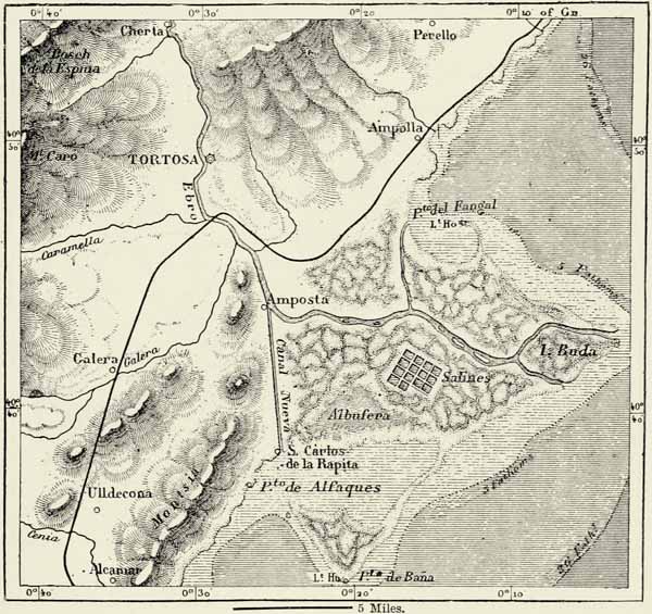
The Ebro, after its junction with the Segre, immediately plunges into the coast ranges of Catalonia, and though the fall thence to the sea amounts to 183 feet in 95 miles, no rapids or cataracts are met with. The suspended matter brought down by the river has been deposited in the shape of a delta which juts out fifteen miles into the Mediterranean, covers an area of 150 square miles, and abounds in salt marshes, lagoons, and dead river arms. A canal, twenty-two miles in length, connects the harbour of refuge at Alfaques with the Ebro, but is not available for ships of great draught, owing to the bar which closes its mouth. The other embouchures of the river are likewise closed by bars.
The volume of the Ebro154 decreases annually, on account of the increasing {433} quantities of water which it is called upon to furnish for purposes of irrigation, and sooner or later it will be reduced to the condition of the rivers of Valencia.
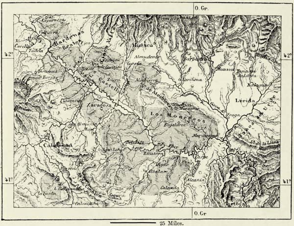
The productiveness of the irrigated fields of Aragon and Catalonia bears witness to the fertility of the soil. Even saline tracts have been converted into gardens. Tropical plants, agaves, cacti, and a few feathery palms on the coast to the south of Barcelona recall the beautiful landscapes of Southern Spain. The valley of the Ebro holds an intermediate position between Murcia and Valencia and the bleak plateau and mountains of the interior; but water, except in the immediate neighbourhood of the rivers, is nowhere abundant. On some of the hill-tops may be seen houses the walls of which are dyed red, because it was found more economical to mix the mortar with wine than to convey thither water for that purpose. This deficiency of moisture is a great drawback to certain districts in the lower valley of the Ebro. The greater portion of Bárdenas, the Monegros, and the terraces of Calanda are treeless steppes. Cold and heat alternate abruptly, without reference to seasons, and the climate, in spite of the proximity of the sea, is quite continental in its character. The hot winds, so much dreaded on the coast of Catalonia, do not blow from Africa, but from the parched plains of Aragon.
The climate of Catalonia, owing to the breezes blowing from the Mediterranean, is far more equable than that of Aragon, and to this circumstance, no less than to differences of race and greater facilities for commerce, this province is indebted for its distinct individuality.155
Catalonia, being open to invasions from the sea as well as by land, has a much more mixed population than its neighbour Aragon. On the other hand, a conqueror once in possession of the latter had but little to fear expulsion at the hands of new-comers, and the Moors maintained themselves in Aragon three hundred years after they had been expelled from Barcelona.
The inhabitants of the valley of the Ebro are offensively haughty, of sluggish minds, given to old customs and superstitions, but they are at the same time singularly persistent, and their bravery does credit to their Celtiberian ancestors. These fine broad-shouldered men, who follow their donkeys along the high-roads, the head enveloped in a silken kerchief, and the waist confined by a violet-coloured belt, are at all times ready for a fight. Up to the close of last century it was customary to get up fights between villages in mere wantonness, and the rondallas, a term now employed for open-air concerts, scarcely ever terminated without bloodshed. In trifles the Aragonese are as stubborn as in matters of importance, and they are said to “drive in nails with their head.” For several centuries the Aragonese struggled with the Moors, and the kings, dependent as they were upon the support of the people, felt constrained to submit to a considerable limitation of their power. It was Philip II. of Castile who suppressed these ancient provincial privileges, and condemned Aragon to lead a life of intellectual stagnation.
The Catalans are as self-opinionated as their neighbours the Aragonese; noisy quarrels frequently take place amongst them; but they rarely come to blows. They {434} are said to be less firm of character than the Aragonese, yet they succeeded in maintaining their provincial independence much longer. Few towns have stood more sieges than Barcelona, and fewer still have offered a more valiant defence. The Catalans are undoubtedly industrious. They have not only converted the irrigable valleys facing the sea into gardens, but have likewise attacked the arid mountains, and, by triturating the rocks and carrying thither soil from the plain, have made them produce grapes, olives, and corn. Hence the proverb, “A Catalan can turn stones into bread.” Agriculture, however, does not wholly supply the wants of so dense a population, and Barcelona with its suburbs has become a huge manufacturing centre, where cottons, woollens, and other textile fabrics, hardware, chemical preparations, glass, paper, and various articles are produced. The province of Barcelona is the chief seat of the cotton industry in Spain, and fully deserves to be called the Spanish Lancashire.156 The Catalans are a migratory race. They are met with not only in every other province of Spain, but in all the Spanish colonies. Everywhere they are reputed for their thrift, and in Cuba are hated as rivals or masters by creoles and blacks.
The towns of Aragon and Catalonia present the same contrasts as do the inhabitants of the two provinces. Those of the former are of solemn and even gloomy aspect, whilst the picturesque cities of the maritime province are full of bustle and mirth. The former represent the Middle Age, the latter our modern era.
Zaragoza (Saragossa) is most favourably situated in the very centre of the plain of Aragon. It has its Moorish alcázar (the Aljaferia), now used as a barrack; a curious leaning tower similar to that of Pisa; and fine promenades, including the Coso and shaded walks. But prouder than of all these attractions are the inhabitants of the epithet “heroic,” which was bestowed upon their city in consequence of the valiant resistance it offered in 1808 and 1809, when they not only defended their homes, but also their patron saint, the Virgen del Pilar.
At Zaragoza a few wide avenues have been cut through the labyrinth of tortuous streets, but the other towns of the province have preserved their physiognomy of former days. Jaca, in the upper valley of the Aragon, between the Pyrenees and the Sierra de la Peña, with its grey houses, still retains its turreted walls and ancient citadel. It is the old capital of the kingdom of Sobrarbe, but would hardly be mentioned now if it were not for its position at the foot of the Pass of Canfranc, and the neighbouring monastery of La Peña. Huesca, at the base of the hills, the Osca of the Romans, recalls the dominion of the Ausks, or Euskarians. Standing in the midst of an irrigated plain, it still enjoys a certain importance. It boasts of a richly decorated cathedral, deserted monasteries, an old royal palace now occupied by the university, and the remains of a turreted wall. Barbastro, near the river Cinca, occupies a position similar to that of Huesca. The carriage road over the Somport connects it with France.
The Arab city of Calatayud, on the river Jalon, is commercially the second city of Aragon, and replaces Bilbilis of the Iberians, which stood on a hill near it. {435} One of its most nauseous suburbs is wholly inhabited by mendicants. Teruel, on the Guadalaviar, the chief town of the Maeztrazgo, with its crenellated walls and turrets, resembles a mediæval fortress. The Arab tower of its church is one of the curiosities of “untrodden” Spain, and its aqueduct, which crosses a valley on 140 arches, is a remarkable work of the sixteenth century.
Several towns of the interior of Catalonia are equally venerable in their aspect. “Proud” Puigcerda (Puycerda), close to the French frontier, on the Upper Segre, is hardly more than a collection of hovels surrounded by a rampart. Seo de Urgel, in a fertile portion of the same valley, is no doubt of some importance as a fortress, but its streets are dirty, its houses mean, and its mud walls dilapidated.
Μ
Fig. 169.—THE DELTA OF THE EBRO.
Scale 1 : 375,000.
Still lower down the Segre we meet with the ancient city of Lérida, whose origin dates back to prehistoric times, and which, owing to its strategical position, has at all times played a prominent part in military history. The gardens of Lérida supply much produce for exportation, but the place cannot rise into importance until the Franco-Spanish coast railway shall have been completed.
Tortosa, a picturesque city just above the delta of the Ebro, and formerly the capital of an Arab kingdom, commands one of the passages over the Ebro, {436} and its commerce would increase if the river offered greater facilities for navigation.
Tarragona in the time of the Romans was the great maritime outlet of the valley of the Ebro. The city was then nearly forty miles in circumference, with arenas, amphitheatres, palaces, temples, and aqueducts, and a population of hundreds of thousands. The ruins of this ancient Tarraco have been made use of in the construction of the modern city, with its clumsy cathedral, towers, decayed ramparts, and Roman aqueduct intersecting the suburban orange groves. The manufacturing town of Reus may almost be looked upon as a suburb of it, and is rapidly increasing in population. Near it is the monastery of Poblet, in which are deposited the remains of the Kings of Aragon.
Μ
Fig. 170.—THE STEPPES OF ARAGON.
According to Willkomm. Scale 1 : 2,000,000.
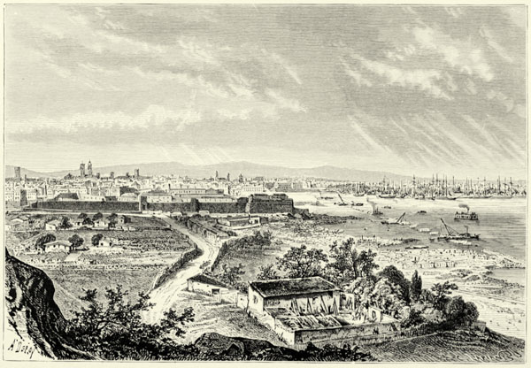
BARCELONA, SEEN FROM THE CASTLE OF MONJUL.
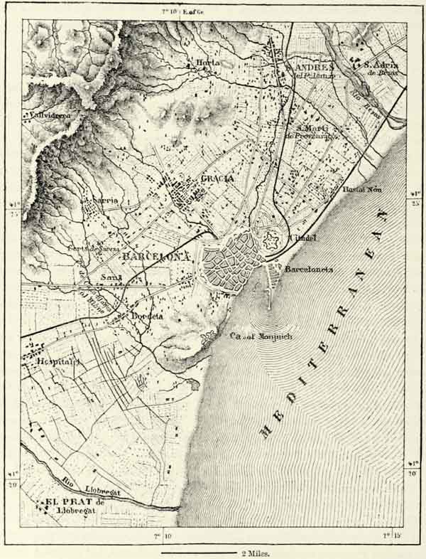
The country between Tarragona and Barcelona is densely populated. We pass through the fertile district of El Panadés, the equally fertile valley irrigated by the reddish waters of the Llobregat, with towns and villages in rapid succession, until we reach the suburbs of Barcelona. The city proper lies on the sea, at the foot of the fortifications crowning the steep heights of Monjuich. There is another citadel of immense size to the east of the city, yet this latter reposes gaily beneath its batteries, which could easily reduce it to ashes. Barcelona boasts of being the great pleasure town of Spain. Its population is less than that of Madrid, but there are more theatres and concert halls. The dramatic performances are of a superior class, and the taste of the people is more refined. The public promenades, such as the Rambla, occupying the bed of an ancient torrent, the {437} sea-walls, and the avenues of trees which separate Barcelona from the citadel and the suburb of Barceloneta, are crowded on fine evenings. Barcelona is no doubt the “unique city” of Cervantes, and perhaps “the home of courtesy and of valiant men;” but we doubt its being the “common centre of all sincere friendships.” Barcelona exceeds all other towns of Spain by its commerce.157 The harbour is exposed to southerly winds, and somewhat difficult of access. Barcelona is ever renewing itself. There are broad streets of uniformly built houses, and some quarters, as that of Barceloneta, on a tongue of land to the east of the port, are laid out with all the regularity of an American city. The only architectural monuments of note are a Gothic cathedral and the old palace of the Inquisition. But all around the town, beyond the suburbs with their factories and workmen’s dwellings, we meet with numerous villas, occupying delightful nooks in verdant valleys or the steep hill-slopes. No more charming district exists in Spain than that to the north of Barcelona and Badalona, extending as far as Masnou, Mataró, and the river Tordera. Promontories covered with vines, pines, and cork-oaks, and sometimes crowned by the ruins of a castle, project into the sea; the valleys are laid out in gardens enclosed with aloe hedges; towns and villages follow in rapid succession; and the boats and nets of fishermen are seen on the beaches.
Most towns of the province of Barcelona emulate the manufacturing industry of the capital. Igualada, at the foot of the Monserrat; Sabadell, in a valley, full of factories; Tarrasa, the old Roman city, near which are the famous baths of La Puda; Manresa, on the Cardoner rivulet; Vich, the old primatial city of Catalonia; and Mataró, on the coast, are all distinguished for the manufacture of cloth, linens, silks, cotton stuffs, ribbons, lace, leather, hats, faience, glass, or paper. Manufacturing industry has likewise spread into the neighbouring province of Gerona, and notably to the city of Olot; but the vicinity of the French frontier, the practice of smuggling, and the presence of large garrisons in the fortresses of Gerona and Figueras have hindered its development. Gerona has sustained many a siege, and Figueras, in spite of its huge citadel, has been repeatedly captured. The walls of Rosas are crumbling to pieces, and every vestige of the Greek city of Emporion has been buried beneath the alluvium brought down by the river Fluvia, but it still lives in the name of the surrounding district of Ampurdan.158
The crest of the Pyrenees constitutes for the most part the political boundary between France and Spain, but there are exceptions to this rule. At the western extremity of the chain Spain enjoys the advantage, for the valley of the Bidassoa, on the French slopes, belongs to it; but France is compensated in the east by the possession of Mount Canigou and the valley of the Upper Segre. As a rule, however, Spain has the best of the bargain, and this is only natural, as the Pyrenees are most accessible from the south, and the population there is more dense. The {438} herdsmen of Aragon and the Basque provinces never missed an opportunity of taking possession of pastures on the northern slopes of the mountains, and these encroachments were subsequently ratified by international treaties.
The valley of Aran, in the very heart of the Pyrenees, is one of these bloodless conquests of Spain. The French Garonne rises in that valley, but the defile through which it leaves it is very narrow and easily obstructed. Up to the eighteenth century the Aranese enjoyed virtual independence; and as they are shut off from the rest of the world by mountains covered with snow during the greater part of the year, these 21,000 mountaineers would appear to possess more claim to constitute themselves an independent republic than any other people in Europe.
Farther east there is another mountain valley which, nominally at least, forms an independent republic. This is Andorra, a territory of 230 square miles, with 6,000 inhabitants. A few pastures on the French slope excepted, the whole of this valley is drained by the beautiful stream of Embalira, or Valira, which joins the Segre in the smiling plain of Seo de Urgel. Most of the mountains of Andorra have been robbed of their trees, and the destruction of the few remaining forests is still going on. The vegetable soil is being rapidly washed away, and the moraines of ancient glaciers gradually slide down the mountain slopes.
The republic of Andorra is said to owe its existence to a defeat of the Saracens by Charlemagne or Louis le Débonnaire, but in reality up to the French Revolution the valley enjoyed no sovereign rights whatever. It was a barony of the Counts of Urgel and of Aragon. In 1278 it was decided that Andorra should be held jointly by the Bishops of Urgel and the Counts of Foix. In 1793 the French republic declined to receive the customary tribute, and in 1810 the Spanish Cortes abolished the feudal régime. Andorra thus became an independent state. The inhabitants, however, continue to govern themselves in accordance with old feudal customs, which are not at all reconcilable with the principles of modern republics. The land belongs to a few families. There is a law of entail, and younger brothers become the servants of the head of the family, whose hospitality they enjoy only on condition of their working for him. The tithes were only abolished in 1842. The “liberty” of these mountaineers consists merely in exemption from the Spanish conscription and impunity in smuggling; and, to increase their revenues, they have recently established a gambling-table. Their legitimate business consists in cattle-breeding, and there are a few forges and a woollen factory.
The republic of Andorra recognises two suzerains, viz. the Bishop of Urgel, who receives an annual tribute of £25, and the French Government, to whom double that sum is paid. Spain and France are represented by two provosts, the commandant of Seo de Urgel exercising the functions of viceroy. The provosts command the militia and appoint the bailiffs, or judges. They, together with a judge of appeal, alternately appointed by France and Spain, and two rahonadores, or defenders of Andorran privileges, form the Cortes. Each parish is governed by a consul, a vice-consul, and twelve councillors elected by the heads of families. A General Council, of which the consuls and delegates of the parishes are members, meets at the village of Andorra. But in spite of these fictions Andorra is an {439} integral part of Spain, and the carabineers never hesitate to cross the frontiers of this sham republic. By language, manners, and customs the Andorrans are Catalans. Exemption from war has enabled them to grow comparatively rich. They are intelligent and cunning, and well know how to assume an air of astonishment when their interests are at stake. Acting the fool, in order to take some one in or avoid being ensnared, is called by their neighbours “playing the Andorran.” Andorra, a neat village, is the capital of the territory, but San Julia de Loria is the most important place, and the head-quarters of the smugglers.
VII.—BASQUE PROVINCES, NAVARRA, AND LOGROÑO.*
The Basque provinces (Vascongadas) and the ancient kingdom of Navarra, though scarcely a thirtieth part of Spain, constitute a separate region, not only on account of geographical position, but also because they are inhabited for the most part by a distinct race, having its own language, manners, and political institutions.
Looked at from a commanding position, the hills connecting the Pyrenees with the Castilian plateau resemble a sea lashed by contrary winds, for there are no prominent mountain ranges. Even the Pyrenees have sunk down to a mean height of 3,000 feet, and the Lohihulz (3,973 feet), where they cease to form the frontier, scarcely deserves to be called a mountain. They extend thence to the Pass of Azpiroz (1,860 feet), where they terminate. The vague range beyond is known as Sierra de Aralar (4,330 feet), and still farther west by a variety of local names. These mountains are traversed by several low passes, facilitating communication with the valley of the Ebro, the most important of which is the Pass of Orduña (2,134 feet), which is crossed by the railway from Bilbao to Miranda, and dominated by the Peña Gorbea (5,042 feet) and the Sierra Salvada (4,120 feet).
The spurs which descend from these mountains towards the Bay of Biscay are likewise very irregular in their features. Most of them are connected by transversal chains, through which the rivers have only with difficulty forced for themselves an outlet towards the sea. The Bidassoa, for instance, sweeps far to the south, through the valley of Bastan, before it takes its course to the northward, in the direction of its estuary at Fuenterrabia. Within its huge bend it encloses a detached portion of the Pyrenees, the principal summit of which is the famous Mont La Rhune (2,954 feet), on the French frontier. Equally isolated is the Jaizquibel (1,912 feet), which rises from the plains of Irun, close to the mouth of the Bidassoa, and from whose summit there is a view of incomparable beauty. It terminates in Cape Higuer, or Figuer, the northernmost point of Cantabria.
The maritime slope of the Basque countries presents a great variety of geological formations, including Jurassic limestones and chalk, granites and porphyries. The mineral resources are immense; copper and lead abound, but the great wealth consists in iron. The mines of Mondragon, in Guipúzcoa, have long been famous, but the most productive mining district is Somorrostro, to the west of Bilbao. {440}
Μ
Fig. 171.—THE ENVIRONS OF BARCELONA.
Scale 1 : 100,000.
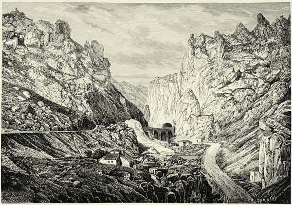
GORGES OF PANCORBO.
The sierras of Aragon running parallel with the Pyrenees extend also into Navarra and the Vascongadas, and are frequently connected with the main range by lateral branches. To the west of Pamplona they spread out into a rugged plateau, surmounted by the Sierra de Andía (4,769 feet), the labyrinthine ramifications of which occupy the district of Amezcuas, a region offering great advantages to partisan warfare. The southern chain, not so well defined, bounds the Carrascal, or “country of evergreen oaks,” in the south. This region, too, has frequently been the scene of civil war. Farther west the famous defile of Pancorbo leads through the Montes {441} Obarenes (4,150 feet) to the plateau of Castile. The saddle of Alsásua (1,955 feet), over which passes the railway from Vitoria (1,684 feet) to Pamplona (1,378 feet), connects the Pyrenees with the Sierra de Andía, whilst as to the mountains of the province of Logroño, they are spurs of the mountain masses forming the northern edge of that plateau, viz. the Sierra de la Demanda in the west, and the Sierra de Cebollera in the east, the latter giving birth to the Sierras de Camero.
Several of the mountain districts are quite Castilian in their asperity and nakedness, for the forests have been cut down to feed the iron furnaces. In Southern Navarra we meet with veritable deserts. But in the Basque countries and Western Navarra, where it rains copiously, the hills are clad with forests, the valleys with turf, and rivulets wind amongst groves of elder-trees. Naked precipices of sand or limestone contrast well with this verdure, from which peep out the small white houses of villages embosomed in orchards, and scattered in the valleys and hill-sides.
Μ
Fig. 172.—THE SAND-BANKS OF MATARÓ.
Scale 1 : 125,000.
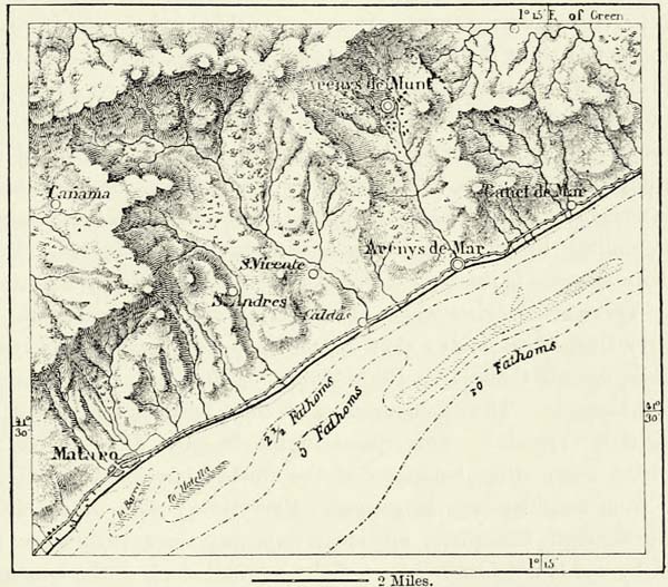
Moist north-westerly winds are frequent in the Bay of Biscay, and account for the equable temperature of the country. It rains abundantly, and in all seasons. The climate resembles that of Ireland, and, though damp, it is healthy and most conducive to the growth of vegetation. The country is rich in corn, wine, oil, and cattle; the northern slopes are covered with fruit trees of every kind, and zagardua, or cider, is a favourite drink; and in the more remote valleys of the Pyrenees we meet with some of the most magnificent forests in Spain. That of Val Cárlos (valley of Charlemagne), near the famous Pass of Roncevaux, or Roncesvalles, though none of the largest, is reputed for its beauty and legendary associations. {442}
Who are the Basques, whose bravery is traditional? What is their origin? What their relationship to the other peoples of Europe? All these questions it is impossible to answer. The Basques are a mysterious race, and can claim kinship with no other nation. It is not even certain whether all those who pass by that name are of the same race. There is no typical Basque. No doubt most of the inhabitants of the country are distinguished by finely chiselled features, bright and firm eyes, and well-poised bodies, but the differences in stature, form of skull, and features are very considerable. Between Basque and Basque the differences are as great as between Spaniards, Frenchmen, and Italians. There are tall men and short, brown and fair, long skulls and broad, and almost every district has its distinct type. The solution of this problem is daily becoming more difficult, for, owing to a continual intermixture with their neighbours, the original type, if there really existed one, is gradually being obliterated. It is possible that at some remote time the remnants of various races occupied this country, and adopted the language of the most civilised among them. Instances of this kind abound in every people.
Leaving out of sight the differences existing between the Basques of Spain and those of French Navarra, the Basques may be described as having broad foreheads, straight noses, finely shaped mouths and chins, and well-proportioned figures. Their features are exceedingly mobile, and every sentiment is reflected upon them by a lighting up of the eyes, a movement of the eyebrows, or a trembling of the lips. The women especially are distinguished by the purity of their features; their large eyes, smiling lips, and small waists are universally admired. Even in the towns, where the race is least pure, most of them are strikingly beautiful and full of grace. There are districts where obesity is a veritable phenomenon. Men and women carry themselves nobly; they are polite to strangers, but always dignified.
The Basques call themselves Euskaldunac, or Euskarians, and their language Euskara, or Eskuara. The exact meaning of these terms is not known, but in all probability it is “speech.” This speech of the Basques differs in its words and structure from every other language of the world; but many words have been borrowed from neighbouring languages. Everything with which they became acquainted through foreigners, all ideas imported since prehistoric times, are designated by words not forming part of the original stock of the language. Even the names of domestic animals and metals are of foreign origin. The language may, perhaps, be classed with the polysynthetic languages of the American Indians, or with the agglutinant idioms of the Altai, and belongs, consequently, to the most remote period of human history. As to the Basques themselves, they declare their speech to be superior to every other, and according to some it was in Euskara that man first saluted the sun.
For the present we are compelled to look upon the Basques as the last remnant of an ancient race. There are not wanting proofs that the Euskaldunac formerly occupied a far wider territory. No monuments, no inscriptions, nor even legends give a clue to this; but we find it, after thousands of years, in the names of mountains, rivers, and towns. Euskarian names abound in the Pyrenean valleys of Aran, Bastan, Andorra, and Querol, and in the plain to the north of them. {443}
Μ
Fig. 173.—THE VALLEY OF ANDORRA.
Scale 1 : 375,000.
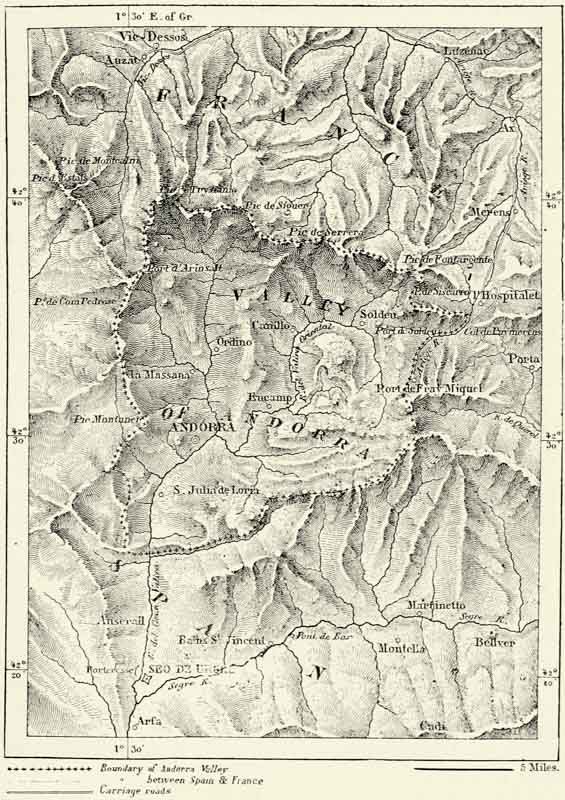
Most writers on Spain identify these Euskarians with the Iberians of the ancients, and they have been credited with being the authors of various inscriptions upon coins written in unknown characters which have been discovered in Spain and Southern France, and which M. Boudard has shown to be really in Euskarian. They must thus have occupied the whole of the peninsula and Southern France, and even in Africa traces of their presence have been discovered. {444}
The extent of territory occupied by Basque-speaking populations in the time of the Romans is not known, but probably it was not any greater than it is now, for the Euskarians have ever since maintained their independence, and nothing compelled them to adopt the language of their despised neighbours. Bilbao has almost become Spanish, as have also the towns in the plain of Álava. Pampeluna, the Irun of the Iberians, is Euskarian merely by historical tradition, whilst farther east Basque is only spoken in the upper valleys of Roncevaux, Orbaiceta, Ochagavia, and Roncal. The Peak of Anie marks the extreme limit of Basque on both slopes of the Pyrenees. Out of four Euskarian provinces there is only one—viz. Guipúzcoa—where Basque predominates; but even in that province the inhabitants of the cities of St. Sebastian and Irun speak Castilian. In the south of Navarra and of the so-called Basque provinces the inhabitants have spoken a Latin dialect from time immemorial. Spanish and French are slowly but surely superseding the Basque, and the time when it will be a thing of the past is not very distant.160
Strabo speaks of the Cantabrians, the direct ancestors of the Basques, with an admiration akin to horror. Their bravery, love of freedom, and contempt of life he looked upon as superhuman qualities. In their wars against the Romans they killed each other to escape captivity, mothers strangled their children to spare them the indignities of slavery, and prisoners nailed to the cross burst into a chant of victory. The Basques have never been wanting in courage. History shows that they were superior to the surrounding nations in uprightness, generosity, love of independence, and respect for personal liberty. The serfs of the neighbouring provinces looked upon them as nobles, for in their abject condition they fancied that personal liberty was a privilege of nobility. This equality, however, existed only in Guipúzcoa and Biscay, whilst in Álava and Navarra, where the Moors gained a footing, and Castilian influences made themselves felt later on, there originated a feudal nobility, with its usual train of vassals and serfs. However, all the provinces have jealously watched over their local privileges. At a period when European history was one continual series of wars, the Basques lived in peace. Their small commonwealths were united into a fraternal confederation, and enabled to resist invaders. They were bound to sacrifice life and property in the defence of their common fatherland, and their standards were emblazoned with three hands joined, and the motto, Irurak bat, i.e. “The three (provinces) are but one.”
Nothing exhibits more strikingly the comparative civilisation of these Euskarians than their respect for personal liberty. The house of a Basque was inviolable, and he could not be deprived of his horse or his arms. At their national meetings all voted, and in some of the valleys even the women were permitted to take part in the discussions. It was not, however, customary for the women to sit down at the same table with the etcheco-jauna, or master of the house, and his sons; they took their meals separately by the side of the hearth. This old custom is still observed in country districts; and so strong is the force of tradition, that the wife would almost consider it a disgrace to be seen sitting by {445} the side of her husband on any other occasion than her wedding-day. On fête-days the women keep apart; they dance amongst themselves, allowing the men to engage in ruder sports. If a nation may be judged from its pastimes, the Basques deserve to rank high in our estimation. They are fond of athletic sports, and mysteries and pastoral pieces are still performed in the open air.
Μ
Fig. 174.—JAIZQUIBEL.
Scale 1 : 200,000.
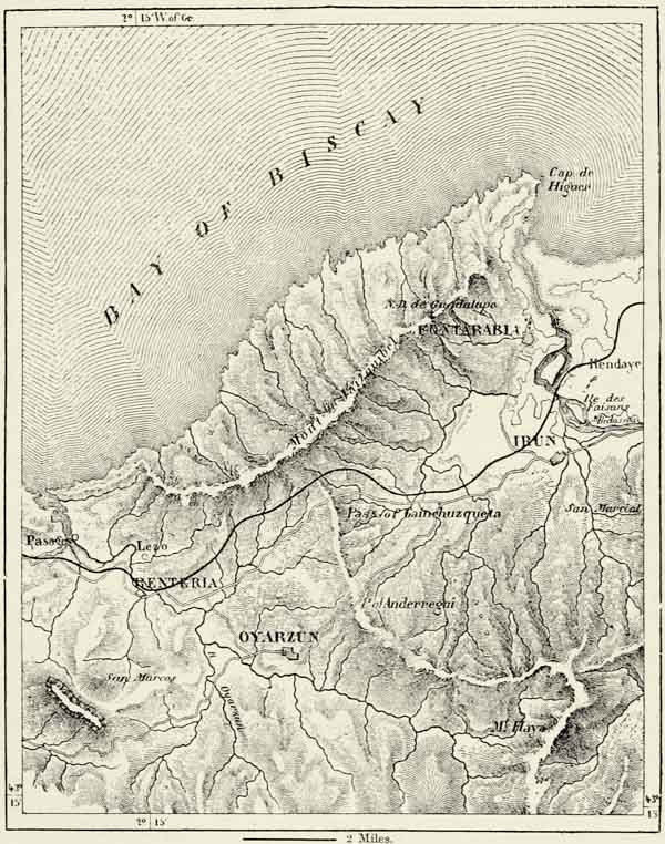
But the Basques have their faults. Anxious to retain their ancient privileges, or fueros, they have become the champions of despotism. These fueros date from 1332, when deputies from the provinces went to Burgos, and offered the title of Lord to Alfonso the Judge, King of Castile. In accordance with the treaty then {446} concluded, the sovereign is prohibited from possessing any fortress, village, or even house within the territory of the Euskarians. The Basques are exempt from the conscription, and their militiamen, or miqueletes, remain within the provinces except in time of war. The taxes can only be levied with the consent of the provincial juntas, and must be expended within the provinces, except what may be granted as a “gift.” Commerce is not subjected to the same restrictions as in the rest of Spain, and there are no monopolies. The municipalities enjoy absolute self-government, carried on by an alcalde, an ayuntamiento, or town council, and parientes mayores, or elders. In appearance this organization is quite democratic, but in reality there exist many feudal usages. In some places the town councils are self-elected; in others they are elected by persons paying a specified amount in taxes, or by nobles of a certain category; in others, again, they are appointed by the lord of the manor. The provincial juntas are elected in most diverse ways. The franchise, far from being universal, is a privilege, and its exercise is attended with puerile formalities. The laws of precedence are rigidly adhered to.
It is quite clear that the exceptional position of the Basque provinces cannot be maintained. Navarra was assimilated with the rest of Spain in 1839, and this process is progressing irresistibly in the other provinces. If the descendants of the Euskarians decline to share free institutions with the rest of Spain, they can never maintain them on their own behalf. Twice already have they been defeated on an appeal to arms; but more powerful than war is the influence exercised by industry, commerce, and increased facilities for intercommunication. This fusion is being hastened by emigration and migration, for the Basques not only seek work during winter in the more hospitable lowland districts, but they also emigrate in thousands. They are very clannish, and at Madrid and elsewhere have founded “Patriotic Societies,” but in spite of these they soon become merged with the rest of the population. The few towns are principally inhabited by strangers, for the Basques prefer a country life. Their homesteads are scattered over hill-slopes and through the valleys, and beneath the oaks in front of them the inmates meet after the day’s labour to pass their time in music and dancing.
Bilbao, the largest town of the Basque provinces, has at all times proved a rival of Valencia, Santander, and Cádiz. Its exports consist principally of iron ores from neighbouring mines. Most of its inhabitants are Spaniards, and during the Carlist wars the environs of the town were frequently stained with blood. It was under its walls that Zumalacarreguy, the Carlist leader, received his deadly wound. The river Nervion connects Bilbao with its harbour at Portugalete.
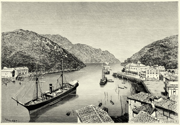
LOS PASAGES.
St. Sebastian, the largest city of Guipúzcoa, is likewise Spanish. A seaport and fortress defended by a Castilian garrison, it resembles in aspect and language the towns of the interior of the peninsula. Monte Orgullo (475 feet), crowned by the Castle de la Mota, and bristling with fortifications; the beautiful Bay of La Concha, to the west of the town, with its fine beach; the river Urumea, which flows to the east of the citadel, and struggles at its mouth with the foam of the sea; shady walks and an amphitheatre of verdant hills dotted with villages, render St. Sebastian a delightful spot, the favourite resort of worn-out and idle {447} cosmopolitans. The town itself is devoid of interest, for since its destruction by the English in 1813 it has been rebuilt with monotonous regularity. Its harbour, though frequented by coasting vessels, is shallow and insecure. The magnificent Bay of Pasages, to the east of the town, might have been converted into a splendid harbour, but its great advantages have never been appreciated, and its mouth is now closed by a bar of alluvium brought down by the Oyarzun.
Μ
Fig. 175.—AZCOITIA AND AZPEITIA.
Scale 1 : 50,000.
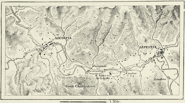
Delightful Fuenterrabia (Fontarabie), with its escutcheoned houses, is likewise shut off from the sea by a bar, and is indebted for such importance as it possesses to its sea baths and the vicinity of France, which is visible from its battered walls. Irun, the terminal station of the Spanish railways, close to the French frontier, is an important strategical position; and Tolosa, with its factories, is the capital of Guipúzcoa. Zarauz, Guetaria (on the neck of a peninsula), and Lequeitio are seaside resorts. Zumaya, at the mouth of the Urola valley, has quarries of gypsum, which furnish excellent cement. Near Vergara are ferruginous springs, and a famous college founded in 1776 by the Basque Society. The convention which put a stop to the first Carlist war in 1839 was signed here. Durango, likewise, has frequently been mentioned in connection with the civil wars carried on in the north of Spain. Guernica, in Biscay, boasts of a palace of justice and an old oak beneath which the legislature is in the habit of meeting; but, like all other Basque towns, it is hardly more than a village.
The centres of population are not more numerous on the southern slope of the Pyrenees. Vitoria, the capital of Álava, on the railway connecting Madrid with Paris, is a commercial and manufacturing town. Pamplona, or Pampeluna, recalls the name of Pompey, who rebuilt it. It is a fortress, often besieged and captured. Its cathedral is one of the finest in Spain. Tafalla, la flor de Navarra, the ancient capital of the kingdom, has the ruins of a palace, which Carlos the Noble, who {448} built it, desired to unite by means of a covered gallery with the palace of Olite, three miles lower down in the same valley. Puente la Reina is celebrated for its wines. Estella, one of the most charming towns of Navarra, commands several roads leading to Castile and Aragon, and its strategical importance is consequently considerable. The Carlists, during the late war, transformed it into a formidable fortress.
Tudela, abounding in wines, Calahorra, and Logroño, all in the adjoining province of Logroño, are likewise of some value from a military point of view, for they command the passages over the Ebro. Calahorra, with its proud motto, “I have prevailed over Carthage and Rome,” was the great bulwark of defence when Sertorius fought Pompey, but was made to pay dearly for its heroism. Besieged by the Romans, its defenders, constrained by hunger, fed upon their women and children, and most of them perished. Though situated in the fertile district of Rioja, beyond the frontiers of the Euskarian language, the history of Calahorra is intimately connected with that of the Basque provinces, for upon its ancient laws were modelled the fueros of Álava.161
VIII.—SANTANDER, THE ASTURIAS, AND GALICIA.
The Atlantic slope of the Cantabrian Pyrenees is a region completely distinct from the rest of Spain. Mountains, hills, valleys, and running waters succeed each other in infinite variety, and the coast throughout is steep, with bold promontories and deep inlets, into which flow rapid torrents. The climate is moist and salubrious. The Celto-Iberian inhabitants of the country have in most instances escaped the commotions which devastated the other provinces of the peninsula, and the population, in proportion to the cultivable area, is more dense than elsewhere. This region, being very narrow compared with its length, has been split up into several political divisions, in spite of similarity of physical features. The old kingdom of Galicia occupies the west, the Asturias the centre, and Santander the east.162
The mountain region of Santander begins immediately to the east of the Sierra Salvada and the depression known as Valle de Mena. The Cantabrian Mountains slope down steeply there towards the Bay of Biscay, whilst their height above the upland, through which the Ebro has excavated its bed, is but trifling. The Puerto del Escudo attains an elevation of 3,241 feet above Santander, its southern descent to the valley of the Virga hardly exceeding 500 feet. The Pass of Reinosa (2,778 feet), farther west, through which runs the railway from Madrid to Santander, is even more characteristic. An almost imperceptible height of land there separates the plateau from the steep declivity which leads down to the coast, and by means of a canal sixty feet deep, and a mile in length, the waters of the Ebro might be diverted into the river Besaya, which enters the Atlantic at San Martin de Suances. This height of land forms the natural outlet of {449} the Castiles to the sea, and its possession is as important to the inhabitants of the plateau as is that of the mouth of a river to a people dwelling on its upper course.
Μ
Fig. 176.—THE ENVIRONS OF BILBAO.
Scale 1 : 200,000.
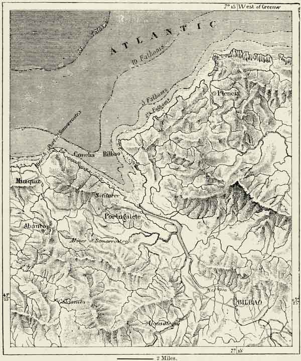
Immediately to the east of this pass the aspect of the mountains changes. They rise to a great height, piercing the zone of perennial snow, and their southern escarpments are of great steepness. The Peña Labra (8,295 feet) dominates the first of these mountain masses. Rivers descend from it in all directions: the Ebro in the east, the Pisuerga in the south, and the Nansa, or Tinamenor, in the north-west. Farther west the Peña Prieta rises to a height of 8,295 feet, its snows feeding the Carrion and Esla. It is joined in the north to a mountain mass even more considerable, which bears the curious name of Peñas de Europa, or “rocks {450} of Europe,” and culminates in the Torre de Cerredo (8,784 feet), covered with snow throughout the year, and boasting even of a few glaciers, due to the excessive amount of precipitation.
Μ
Fig. 177.—ST. SEBASTIAN.
Scale 1 : 30,000.
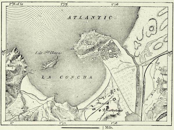
The valley of La Liébana, at the eastern foot of the Peñas de Europa, resembles a vast caldron of extraordinary depth. Shut in on the west, south, and east by huge precipices rising to a height of 6,500 feet, it is closed in on the north by a transversal chain, through which the waters of the Liébana have excavated for themselves a narrow passage. The village of Potes, in the centre of this valley, lies at an elevation of only 981 feet above the level of the sea. In Santander and the Asturias, even more frequently than in the Basque country, we meet with secondary chains running parallel with the coast. These are composed of triassic, Jurassic, and cretaceous rocks, and rise like advanced walls of defence in front of the main range of the mountains, which consist of Silurian slates upheaved by granite. It results from this that the course of the rivers is most erratic. On leaving their upper valleys, where they frequently form cascades, their farther progress is arrested by these parallel ranges, and they twist about to the east and west until they find an outlet through which they may escape.
The two funnel-shaped valleys of Valdeon (1,529 feet) and Sajambre are enclosed between spurs of the Peñas de Europa. Their torrents drain into the Bay of Biscay, but they are most readily accessible from the plateau. Farther west the mountains decrease in height, and their main crest gradually recedes from the coast. They are crossed here by the Pass of Pajares (4,471 feet), which connects Leon with Oviedo. {451}
The Asturian Mountains are objects of veneration to every patriotic Spaniard. Beautiful as they are, their lower slopes being covered with chestnut-trees, walnut-trees, and oaks, whilst higher up forests of beeches and hazel alternate with meadows, their beauty is enhanced by the fact of their having afforded a refuge to the Christians whilst the Moors held the rest of the country. Mount Ansena sheltered St. Pelagius and his flock, and at Covadonga he built himself an abbey. These “illustrious mountains” do not, however, merely boast of historical associations, delightful villages, herds, and pastures; they hide within their bowels a rich store of coal, one of the principal sources of wealth to the Asturias.
Fig. 178.—ST. SEBASTIAN.
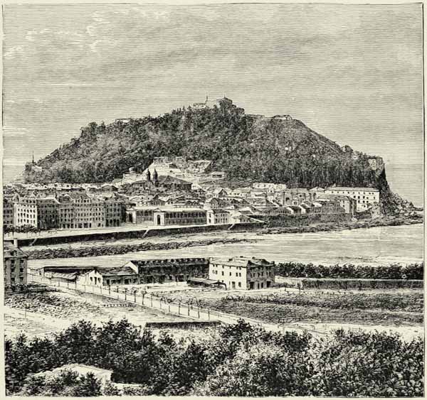
Galicia is separated from the Castilian plateau by a continuation of the Cantabrian Pyrenees, which here swerve to the south, and through which the Sil has excavated its bed. To the north of that river they culminate in the Pico de Miravalles (6,362 feet), and are crossed by the Pass of Predrafita (3,600 feet), through which runs the main road from Leon to Galicia.
Μ
Fig. 179.—GUETARIA.
Scale 1 : 8,000.
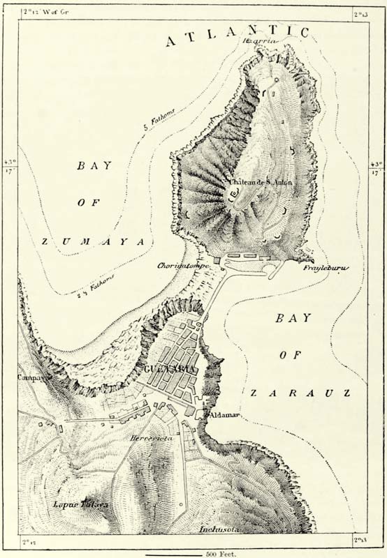
In Galicia the hills rarely form well-defined chains, and mostly consist of {452} primitive rocks or small table-lands, with peaks or summits rising a few hundred feet above the general level of the country. The disposition of the small ranges generally corresponds with that of the coast. The Sierra de Rañadoiro (3,612 feet), a spur of the Cantabrian Mountains, forms the natural boundary between the {453} Asturias and Galicia. West of it, the Sierra de Meira (2,982 feet) runs in the same direction, but the chains which terminate in Capes Estaca de Vares and Ortegal (i.e. Nortegal, “north cape”) run from east to west, and are dominated by the pyramid of Monte Cuadramon (3,342 feet). The hills to the west of the river Miño (Minho) terminate in the famous promontories of Toriñana and Finisterre, or “land’s-end.” This latter, a steep cliff rising boldly above the waters to the west of the wide Bay of Corcubion, formerly bore a temple of the ancient gods, since replaced by a church dedicated to the Virgin.
Μ
Fig. 180.—GUERNICA.
Scale 1 : 100,000.
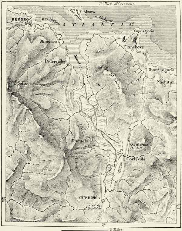
{454}
The coast of the Asturias abounds in small bays, or rias, bounded by steep cliffs. In Galicia these rias assume vast proportions, and are of great depth. They may fitly be likened to the fiords of Northern Europe, and their origin appears to be the same. The marine fauna of these Galician rias is Britannic rather than Lusitanian, for amongst two hundred species of testacea collected by Mr. MacAndrew there are only twenty-five which were not also found on the coasts of Britain. Moreover, the flora of the Asturian Mountains is very much like that of Ireland; and these facts go far in support of the hypothesis, started by Forbes, that the Azores, Ireland, and Galicia, anterior to the glacial epoch, were connected by land.
Μ
Fig. 181.—PASS OF REINOSA.
Scale 1 : 300,000.
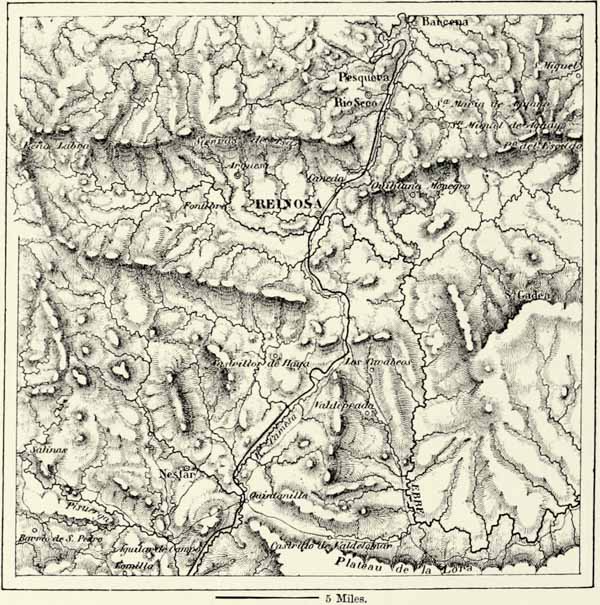
The climate, too, resembles that of Great Britain. The rainfall on the exterior slopes of the mountains is abundant, whilst to the south of them, in the arid plains of Leon and Castile, it hardly rains at all. There are localities in the Asturias where the rainfall amounts to more than six feet annually, a quantity only again met with on the western mountain slopes of Scotland and Norway, and on the southern declivities of the Swiss Alps. There is no season without rain, and {455} droughts are exceedingly rare. Equinoctial storms are frequent in autumn, and render the Bay of Biscay dangerous to mariners. The temperature is equable, and fogs, locally known as bretimas, are as frequent as in the British Islands. These fogs exercise a strong influence upon the superstitious minds of the Galicians, who fancy they see magicians, or nuveiros, ride upon the clouds, expand into mists, and shrink back into cloudlets. They also believe that the bodies of the dead are conveyed by the mists from cemetery to cemetery, these fearful nocturnal processions being known to them as estadeas, or estadhinas.163
In spite of an abundance of running water, the Cantabrian provinces cannot boast of a single navigable river. In the Asturias the littoral zone is too narrow, and the slope too considerable, to admit of torrents becoming tranquil rivers. Nor are the Tambre and Ulla, in Galicia, of any importance; and the only true river of the country is the Miño, called Minho by the Portuguese on its lower course, where it forms the boundary between the two states of Iberia. The Miño is fed from both slopes of the Cantabrian Mountains, the Miño proper rising on the western slope, whilst the Sil comes from the interior of the country. The latter is the main branch. “The Miño has the reputation,” say the Spaniards, “but the Sil has the water.” The Sil, before leaving the province of Leon, passes through the ancient lake basin of the Vierzo, now shrunk to a small sheet of water known as the Lago de Carrocedo. It then passes in succession through a wild gorge, a second lake basin, the tunnel of Monte Furado (“pierced mountains”), excavated by the Romans to facilitate their mining operations, and finally rushes through a gorge intersecting the Cantabrian Mountains, and one of the wildest in all Spain, with precipitous walls more than 1,000 feet in height. Immediately below the confluence with the Miño a second gorge has to be passed, but then the waters of the river expand, and flow into the sea through a wide estuary. Below Tuy, for a distance of about twenty miles, the river is navigable. But though of small service to navigation, the Miño is nevertheless one of the eight great rivers of the Iberian peninsula, and proportionately to the extent of its basin it is the most copious.164
The water of this and other rivers is not needed for agricultural purposes, for it rains abundantly in Galicia and the Asturias, and the emerald meadows of these provinces are as famous as those of England. The flora, however, is upon the {456} whole more southerly in its features than that of the countries to the north of the Bay of Biscay. The orchards produce not only apples, chestnuts, and walnuts, but also oranges, and in a garden at Oviedo dates ripen in the open air. The great moisture, however, prevents certain plants from attaining the commercial importance they would otherwise possess. The mulberry flourishes, but the culture of silk-worms has only yielded indifferent results, and even the grapes, except in a few favoured localities, yield but sour wine of disagreeable flavour. Cider, on the other hand, enjoys a high reputation, and is even exported to America.
Μ
Fig. 182.—THE PEÑAS DE EUROPA.
Scale 1 : 660,000.
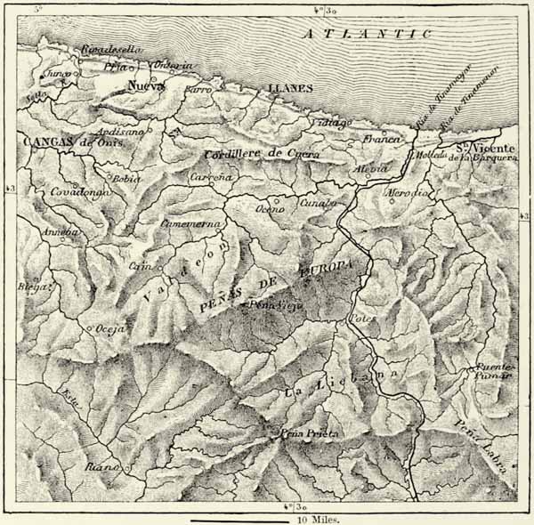
The Asturian boasts of having never submitted to the yoke of Mussulmans. Some of the mountain districts preserved their independence throughout, and nowhere could the Arabs maintain themselves for any length of time. Oviedo was called the “city of bishops,” from the great number of prelates who found a refuge there. The Galicians were equally successful in their resistance to the Moors, and the blood of the Celtic inhabitants of these remote provinces is thus purer than anywhere else in Spain.
In some districts the customs are said to have remained unchanged since {457} the time of the Romans. The herdsmen, or vaqueros, of Leitariegos, on the Upper Narcea, form almost a distinct tribe. They keep apart from the rest of the Asturians, and always marry amongst themselves. Old dialects maintain their ground. The peasants on the coast of Cantabria talk their bable, and in Galicia the dialects differ even from village to village. The gallego, especially as spoken near the Miño, is Portuguese rather than Spanish, but a Lusitanian is nevertheless unable to understand a Galician, owing to the curious sing-song intonation of the latter.
The country supports a dense population, but there are few towns. Many of these consist merely of a church, a town-hall, and an inn. The homesteads are scattered over the whole country. This may be due to an innate love of nature, or perhaps, as in the Basque provinces, to the security which the country has enjoyed during centuries. Foreign and civil wars have scarcely ever affected these outlying provinces of Spain. The manners are gentle, and the bloodthirsty bull-fights of the Castilians unknown. The isolation and peace in which the Cantabrians were permitted to exist did not, however, prove of advantage in all respects. Elsewhere in Europe, nobles, priests, citizens, and the peasantry, when threatened by danger, felt constrained to make concessions to each other. Not so in the Asturias, where the peasants were reduced to the condition of serfs, and sold with the land. At the commencement of this century nearly the whole of the land in the two Asturias was in the hands of twenty-four proprietors, and in the neighbouring Galicia the conditions were not much more favourable. Matters have changed since then. The lords have grown poor, the monasteries have been suppressed, and the industrious Asturians and Galicians have invested their hard-earned savings in land. Formerly the feudal lords leased the land to the cultivators, who rendered homage and paid a quit-rent, the lease remaining in force during the reign of two or three kings, for a hundred years, or even for three hundred and twenty-nine years, according to the custom of different districts. These leases, however, frequently led to disputes; the leaseholders, on the expiration of their leases, often refused to surrender possession, and in numerous instances the law courts sustained them in this refusal.
The Galicians on the coast divide their time between the cultivation of the land and fishing. During the season no less than 20,000 men, with 3,000 or 4,000 boats, spread their nets in the Bays of La Coruña, Arosa, Pontevedra, and Vigo, where tunny-fish and sardines abound. The local consumption of sardines is enormous, and La Coruña alone exports about 17,000 tons annually to America. These pursuits, however, are not capable of supporting an increasing population, and thousands of Galicians emigrate annually. Thrifty and clannish, they usually succeed in amassing a small competency, and those among them who return exercise a civilising influence upon their less-cultivated countrymen. Ignorance and poverty, with all their attendant evils, are great in Galicia, and leprosy and elephantiasis are common diseases.
One great hindrance to the development of the resources of the country consists in the paucity of roads and railways. A beginning has been made, but, looking to the financial condition of Spain, progress will hardly be rapid. {458}
Most of the towns of the Asturias are close to the coast. Castro-Urdiales, Laredo, and Santoña, immediately to the west of the Basque provinces, have frequently served as naval stations. The roadstead of Santoña is one of the most commodious and best sheltered of the peninsula, and when Napoleon gave Spain to his brother Joseph he retained possession of that place, and began fortifications which would have converted it into a French Gibraltar.
Μ
Fig. 183.—RIAS OF LA CORUÑA AND FERROL.
Scale 1 : 210,400.
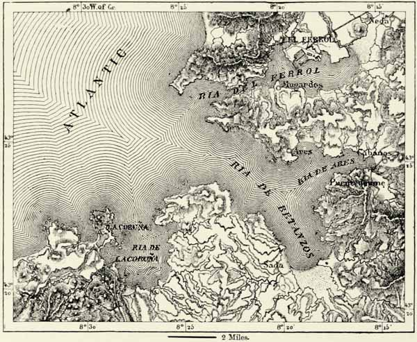
The great commercial port of the country is Santander, with its excellent harbour, quays, docks, and warehouses, built upon land won from the sea. Santander is the natural outlet of the Castiles, and exports the flour of Valladolid and Palencia, as well as the woollen stuffs known as sorianas and leonesas from the places where they are manufactured. It supplies the interior with the colonial produce of Cuba and Puerto Rico, and its merchants keep up regular intercourse with France, England, Hamburg, and Scandinavia.165 The ship-building yards at the head of the bay have lost their former importance, and the manufacture of cigars is now the great industry of the country. Sardinero, a bathing-place to the north of the town, and the hot springs of Alcedo, Ontaneda, Las Caldas de Besaya, in the hills to the south, are favourite places of resort.
Along the coast to the west of Santander, as far as Gijon, we only meet with {459} villages, such as San Martin de la Arena (the port of the decayed town of Santillana), San Vicente de la Barquera, Llanes, Rivadesella, and Lástres. Nor is Gijon, with its huge tobacco factory, a place of importance, though formerly it was the capital of all Asturias. It exports, however, the coal brought by rail from Sarna (Langres), and with Aviles, on the other side of the elevated Cabo de Peñas, enjoys the advantage of being the port of Oviedo, situated in a tributary valley of the Nalon, fifteen miles in the interior. Oviedo has flourishing iron-works, a university, and a fine Gothic cathedral, said to be richer in relics than any other church in the world. The mountain of Naronca shelters the town against northerly winds, and its climate is delicious. The environs abound in delightful spots. At Cangas de Onis, which was the first capital of the kingdom, founded by St. Pelagius, but now merely a village in a charming valley, are the caverns of Covadonga, in which the ashes of the saint have found a last resting-place, and which are consequently objects of the highest veneration to patriotic Spaniards. Trubia, the Government gun and small-arms factory, lies seven miles to the west of Oviedo.
Cudillero, Luarca, Navia (a place said to have been founded by Ham, the son of Noah), Castropol, and Galician Rivadeo are mere fishing villages, and only when we reach the magnificent rias opening out into the Atlantic do we again meet with real towns. The first of these is Ferrol, which was only a village up to the middle of last century, but has since been converted into a great naval station and fortress, bristling with guns, and containing dockyards and arsenals.
La Coruña, the Groyne of English sailors, depends rather upon commerce, manufactures, and fishing than upon its military establishments and fortifications. It is one of the most picturesque towns of Spain, and its favourable geographical position will enable it, on the completion of the railway now building, considerably to extend its commerce, which at present is almost confined to England.166 On a small island near it stands the Tower of Hercules, the foundations of which date back to the Romans, if not Phœnicians. It was from the ria of Coruña that the “Invincible Armada” set out upon its disastrous expedition.
Each of the rias of Southern Galicia has its port or ports. That of Corcubion is sheltered by the Cape of Finisterre; on the ria of Noya are the small towns of Noya and Muros; that of Arosa is frequented by vessels which convey emigrants from the ports of Padron and Carril to La Plata; the ria of Pontevedra extends to the town after which it is named; and farther south still, the towns of Vigo and Bayona rise on the shore of a magnificent bay, protected by a group of islands known to the ancients as “Isles of the Gods.” Vigo, with its excellent harbour, has become the great commercial port of the country,167 but is, perhaps, better known on account of the galleons sunk by Dutch and English privateers.