SPAIN.*
Reading edition
SPAIN.*

I.—GENERAL ASPECTS.
HE Iberian peninsula, Spain and Portugal, must be looked upon geographically as one. Differences of soil, climate, and language may have justified its division into two states, but in the organism of Europe these two constitute but a single member, having the same geological history, and exhibiting unity in their physical configuration.135
Compared with the other peninsulas of Southern Europe, viz. Italy and that of the Balkans, Iberia is most insular in its character. The isthmus which attaches it to the trunk of Europe is comparatively narrow, and it is defined most distinctly by the barrier of the Pyrenees. The contour of the peninsula is distinguished by its massiveness. There are curving bays, but no inlets of the sea penetrating far inland, as in the case of Greece.136
It was said long ago, and with justice, that Africa begins at the Pyrenees. Iberia, indeed, bears some resemblance to Africa. Its outline is heavy, there are hardly any islands along its coasts, and few plains open out upon the sea. But it is an Africa in miniature, only one-fiftieth the size of the continent upon which it appears to have been modelled. Moreover, the oceanic slope of the peninsula is quite European as to climate, vegetation, and abundance of running water; and {371} certain features of its flora even justify a belief that at some remote epoch it was joined to the British Islands. African Hispania only begins in reality with the treeless plateaux of the interior, and more especially with the Mediterranean coasts. There we meet the zone of transition between the two continents. Its general aspect, flora, fauna, and even population, mark out that portion of Spain as an integral part of Barbary; the Sierra Nevada and the Atlas, facing each other, are sister mountains; and the strait which separates them is a mere accident in the surface relief of our planet.
Μ
Fig. 136.—THE TABLE-LANDS OF THE IBERIAN PENINSULA.
Scale 1 : 10,300,000.
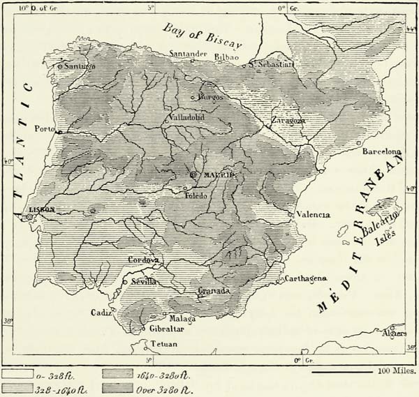
Spain, though nearly surrounded by the sea, is nevertheless essentially continental in its character. Nearly the whole of it consists of table-lands, and only the plains of the Tajo (Tagus) and of Andalusia open out broadly upon the ocean. The coast, for the most part, rises steeply, and the harbours are consequently difficult of access to the inhabitants of the interior, a circumstance most detrimental to the development of a large sea-borne commerce.
Ever since the discovery of the ocean high-roads to America and the Indies, the Atlantic coast of the Iberian peninsula has taken the lead in commercial matters, {372} a fact easily accounted for by the physical features of the country. Spain, like peninsular Italy, turns her back upon the east. The plateaux slope down gently towards the west; the principal rivers, the Ebro alone excepted, flow in that direction; and the water-shed lies close to the Mediterranean shores.
Spain must either have given birth to an aboriginal people, or was peopled by way of the Pyrenees and by emigrants crossing the narrow strait at the columns of Hercules. The Iberian race actually forms the foundation of the populations of Spain. The Basks, or Basques, now confined to a few mountain valleys, formerly occupied the greater portion of the peninsula, as is proved by its geographical nomenclature. Celtic tribes subsequently crossed the Pyrenees, and established themselves in various parts of the country, mixing in many instances with the Iberians, and forming the so-called Celtiberians. This mixed race is met with principally in the two Castiles, whilst Galicia and the larger portion of Portugal appear to be inhabited by pure Celts. The Iberians had their original seat of civilisation in the south; they thence moved northward along the coast of the Mediterranean, penetrating as far as the Alps and the Apennines.
These original elements of the population were joined by colonists from the great commercial peoples of the Mediterranean. Cádiz and Málaga were founded by the Phœnicians, Cartagena by the Carthaginians, Saguntum by immigrants from Zacynthus, Rosas is a Rhodian colony, and the ruins of Ampurias recall the Emporiæ of the Massilians. But it was the Romans who modified the character of the Iberian and Celtic inhabitants of the peninsula, whom they subjected after a hundred years’ war. Italian culture gradually penetrated into every part of the country, and the use of Latin became universal, except in the remote valleys inhabited by the Basques.
After the downfall of the Roman empire Spain was successively invaded by Suevi, Alani, Vandals, and Visigoths, but only the latter have exercised an abiding influence upon the language and manners of the Spaniards, and the pompous gravity of the Castilian appears to be a portion of their heritage.
To these northern invasions succeeded an invasion from the neighbouring continent of Africa. The Arabs and Berbers of Mauritania gained a footing upon the rock of Gibraltar early in the eighth century, and very soon afterwards nearly the whole of Spain had fallen a prey to the Mussulman, who maintained himself here for more than seven centuries. Moors immigrated in large numbers, and they substantially affected the character of the population, more especially in the south. The Inquisition expelled, or reduced to a condition of bondage, hundreds of thousands of these Moors, but its operations only extended to Mussulmans or doubtful converts, whilst Arab and Berber blood had already found its way into the veins of the bulk of the population. Castilian bears witness to the great influence of the Saracens, for it contains many more words of Arabic than of Visigothic origin, and these words designate objects and ideas evidencing a state of progressive civilisation, such as existed when the Arabs of Córdova and Granada inaugurated the modern era of science and industry in Europe. {373}
During the dominion of the Moors the Jews prospered singularly on the soil of Spain, and their number at the time of the first persecution is said to have been 800,000. Supple, like most of their faith, they managed to get a footing in both camps, the Christian and Mohammedan, and enriched themselves at the expense of each. They supplied both sides with money to carry on the war, and, as farmers of taxes, they oppressed the inhabitants. The Christian faith triumphed in the end; the kings, to pay the cost of their wars, proclaimed a crusade against the Jews; and the people threw themselves with fury upon their hated oppressors, sparing neither iron, fire, tortures, nor the stake. A few Jewish families may have escaped destruction by embracing Catholicism, but the bulk of that people perished or were driven into exile.
Far happier has been the lot of the Gipsies, or Gitanos, who are sufficiently numerous in Spain to give a special physiognomy to several large towns. These Gipsies have always conformed outwardly to the national religion, and the Inquisition, which has sent to the stake so many Jews, Moors, and heretics, has never interfered with them. The Gipsies, in many instances, have settled down in the towns, but they all have traditions of a wandering life, and most highly respect those of their kinsmen who still range the woods and plains. These latter are proud of their title of viandantes, or wayfarers, and despise the dwellers in towns. These Spanish Gitanos appear to be the descendants of tribes who sojourned for several generations in the Balkans, for their lingo contains several hundred words of Slav and Greek origin.
M. de Bourgoing has drawn attention to the great diversity existing amongst the population of Spain. A Galician, for instance, is more like an Auvergnat than a Catalonian, and an Andalusian reminds us of a Gascon. Most of the inhabitants, however, have certain general features, derived from a common national history and ancestry.
The average Spaniard is of small stature, but strong, muscular, of surprising agility, an indefatigable walker, and proof against every hardship. The sobriety of Iberia is proverbial. “Olives, salad, and radishes are fit food for a nobleman.” The physical stamina of the Spaniard is extraordinary, and amply explains the ease with which the conquistadores surmounted the fatigues which they were exposed to in the dreaded climate of the New World. These qualities make the Spaniard the best soldier of Europe, for he possesses the fiery temperament of the South joined to the physical strength of the North, without standing in need of abundant nourishment.
The moral qualities of the Spaniard are equally remarkable. Though careless as to every-day matters, he is very resolute, sternly courageous, and of great tenacity. Any cause he takes up he defends to his last breath. The sons always embrace the cause of their fathers, and fight for it with the same resolution. Hence this long series of foreign and civil wars. The recovery of Spain from the Moors took nearly seven centuries; the conquest of Mexico, Peru, and South America was one continued fight lasting throughout a century. The war of independence which freed Spain from the yoke of Napoleon was an almost unexampled {374} effort of patriotism, and the Spaniards may justly boast that the French did not find a single spy amongst them. The two Carlist wars, too, would have been possible nowhere else but in Spain.
Who need wonder, after this, if even the lowliest Spaniard speaks of himself with a certain haughtiness, which in any one else would be pronounced presumptuous? “The Spaniard is a Gascon of a tragic type;” so says a French traveller. With him deeds always follow words. He is a boaster, but not without reason. He unites qualities which usually preclude each other, for, though haughty, he is kindly in his manners; he thinks very highly of himself, but is considerate of the feelings of others; quick to perceive the shortcomings of his neighbours, he rarely makes them a subject of reproach. Trifles give rise to a torrent of sonorous language, but in matters of importance a word or a gesture suffices. The Spaniard combines a solemn bearing and steadfastness with a considerable amount of cheerfulness. Nothing disquiets him; he philosophically takes things as they are; poverty has no terrors for him; and he even ingeniously contrives to extract pleasure and advantage from it. The life of Gil Blas, in whom the Spaniards recognise their own likeness, was more chequered than that of any other hero of romance, and yet he was always full of gaiety, which even the dark shadow of the Inquisition, then resting upon the country, failed to deprive him of. “To live on the banks of the Manzanares,” says a Spanish proverb, “is perfect bliss; to be in paradise is the second degree of happiness, but only on condition of being able to look down upon Madrid through a skylight in the heavens.”
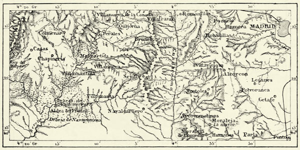
These opposites in the character of the Spaniards give rise to an appearance of fickleness which foreigners are unable to comprehend, and they themselves complacently describe them as cosas de España. How, indeed, are we to explain so much weakness associated with so many noble qualities, so many superstitions in spite of common sense and a keen perception of irony, such ferocity of conduct in men naturally generous and magnanimous? A Spaniard, in spite of his passions, will resign himself philosophically to what he looks upon as inevitable. Lo que ha de ser no puede faltar, “What is to be will be,” he says, and, wrapped up in his cloak, he allows events to take their course. The great Lord Bacon observed, three hundred years ago, that the “Spaniards looked wiser than they were;” and, indeed, most of them are passionately fond of gambling, and their apathetic fatalism accounts for many of the ills their country suffers. The rapid decay which has taken place in the course of three centuries has led certain historians to number the Spaniards amongst fallen nations. The edifices met with in many towns and villages speak of a grandeur now past, and the despoblados and dehesas, which we encounter even in the vicinity of the capital, tell of once fertile fields returned to a state of nature.
Buckle, in his “History of Civilisation,” traces this decay to the physical nature of Spain and to a long succession of religious wars. The Visigoths defended Arianism against the Franks, and when the Spaniards had become good Catholics their country was invaded by Moors, and for more than twenty generations they struggled against them. It thus happened that patriotism became identical with {375} absolute obedience to the behests of the Church, for every one, from the King down to the meanest archer, was a defender of the faith rather than of his native soil. The result might have been foretold. The Church not only took possession of most of the land won from the infidels, but it also exercised a baneful influence upon the Government, and, through its dreaded tribunals of the Inquisition, over the whole of society.
Μ
Fig. 137.—DEHESAS IN THE ENVIRONS OF MADRID.
Scale 1 : 450,000.
But whilst these long religious struggles tended to the moral and intellectual abasement of the Spaniards, there were other causes which operated in an inverse sense, and these Buckle does not appear to have properly appreciated. The kings, in order to secure the support of the people in their wars against the Mussulmans, found themselves compelled to grant a large measure of liberty. The towns governed themselves, and their delegates, as early as the eleventh century, sat with the nobility and clergy in the Cortes, and voted the supplies. Local government conferred advantages upon Spain then enjoyed only in few parts of Europe. Industry and the arts flourished in these prosperous cities, and a stop was even put to the encroachments of the clergy long before Luther raised his powerful voice in Germany.
A struggle between the supporters of local government and of a centralized monarchy at length became imminent, and no sooner had the infidels been expelled than civil war began. It terminated in favour of King and Church, for the comuneros of the Castiles met with little support in the other provinces, and their towns were ravaged by the bloodthirsty generals of Charles V.
The discovery of the New World, which happened about this period, proved a disaster to Spain, for young men of enterprise and daring crossed the Atlantic, and thus weakened the mother country, which was too small to feed such huge colonies. The immense amount of treasure (more than £2,000,000,000 between 1500 and 1702) sent home from the colonies contributed still further to the rapid decay of Spain, for it corrupted the entire nation. Money being obtainable without {376} work, all honest labour ceased, and when the colonies no longer yielded their metallic treasures the country saw itself impoverished, for the gold and silver had found their way to foreign lands, whence Spain had procured her supplies.
Μ
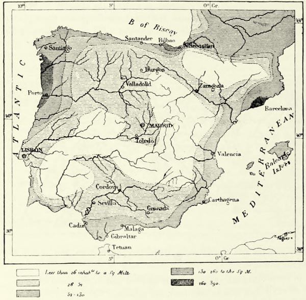
Fig. 138.—DENSITY OF THE POPULATION OF THE IBERIAN PENINSULA.
History affords no other example of so rapid a decadence brought about without foreign aggression. The workshops were closed, the arts of peace forgotten, the fields but indifferently cultivated. Young men flocked to the 9,000 monasteries to enjoy a life of indolence, and “science was a crime, ignorance and stupidity were the first of virtues.” Population decreased, and the Spaniard even lost his ancient renown for bravery. If the Bourbon kings placed foreigners in all high positions of state, they did so because the Spaniards had become incapable of conducting public business.
But if we compare the Spain of our own days with the Spain of the Inquisition, we cannot fail to be struck with the vast progress made. Spain is no longer a “happy people without a history,” for ever since the beginning of the century it has been engaged in struggles, and during this period of tumultuous life it has done more for arts, science, and industry than in the two centuries of peace which succeeded the dark reign of Philip II. No doubt Spain might have done {377} even more if the strength of the country had not been wasted in internal struggles. Unfortunately the geographical configuration of the peninsula is unfavourable to the consolidation of the nation. The littoral regions combine every advantage of climate, soil, and accessibility, whilst the resources of the inland plateaux are comparatively few. The former naturally attract population; they abound in large and bustling cities, and are more densely populated than the interior of the country. Madrid, which occupies a commanding position almost in the geometrical centre of the country, has become a focus of life, but its environs are very thinly inhabited.
This unequal distribution of the population could not fail to exercise a powerful influence upon the history of the country. Each of the maritime provinces felt sufficiently strong to lead a separate existence. During the struggles with the Moors common interests induced the independent kingdoms of Iberia to co-operate, and facilitated the establishment of a central monarchy; but, to maintain this unity afterwards, it became necessary to have recourse to a system of terrorism and oppression. Portugal, being situated on the open Atlantic, shook off the detested yoke of Castile after less than a century’s submission. In the rest of the peninsula political consolidation is making progress, thanks to the facilities of intercommunication and the substitution of Castilian for the provincial dialects; but it would be an error to suppose that Andalusians and Galicians, Basques and Catalans, Aragonese and Madrileños, have been welded into one nation. Indeed, the federal constitution advocated by Spanish republicans appears to be best suited to the geographical configuration of the country and the genius of its population. The desire to establish provincial autonomy has led to most of the civil wars of Spain, whether raised by Carlists or Intransigentes. It is therefore meet that, in our description of Spain, we should respect the limits traced by nature, bearing in mind the fact that the political boundaries of the province do not always coincide with water-sheds or linguistic boundaries.
II.—THE CASTILES, LEON, AND ESTREMADURA.*
The great central plateau of the peninsula is bounded on the north, east, and south by ranges of mountains extending from the Cantabrian Pyrenees to the Sierra Morena, and slopes down in the west towards Portugal and the Atlantic. The uplands through which the Upper Duero, the Tajo (Tagus), and the Guadiana take their course are thus a region apart, and if the waters of the ocean were to rise 2,000 feet, they would be converted into a peninsula attached by the narrow isthmus of the Basque provinces to the French Pyrenees. The vast extent of these plateaux—they constitute nearly half the area of the whole country—accounts for the part they played in history, and their commanding position enabled the Castilians to gain possession of the adjacent territories. {378}
The Castiles can hardly be called beautiful, or rather their solemn beauty does not commend them to the majority of travellers. Vast districts, such as the Tierra de Campos, to the north of Valladolid, are ancient lake beds of great fertility, but exceedingly monotonous, owing to the absence of forests. Others are covered with small stony hillocks; others, again, may be described as mountainous. Mountain ranges covered with meagre herbage bound the horizon, and sombre gorges, enclosed between precipitous walls of rock, lead into them. Elsewhere, as in the Lower Estremadura, we meet with vast pasture-lands, stretching as far as the eye can reach to the foot of the mountains, and, as in certain parts of the American prairies, not a tree arrests the attention. Looking to the fearful nakedness of these plains, one would hardly imagine that a law was promulgated in the middle of last century which enjoins each inhabitant to plant at least five trees. Trees, indeed, have been cut down more rapidly than they were planted. The peasants have a prejudice against them; their leaves, they say, give shelter to birds, which prey upon the corn-fields. Small birds, nightingales alone excepted, are pursued without mercy, and a proverb says that “swallows crossing the Castiles must carry provisions with them.” Trees are met with only in the most remote localities. The hovels of the peasantry, built of mud or pebbles, are of the same colour as the soil, the walled towns are easily confounded with the rock near them, and even in the midst of cultivated fields we may imagine ourselves in a desert. Many districts suffer from want of water, and villages which rejoice in the possession of a spring proclaim the fact aloud as one of their attributes. Huge bridges span the ravines, though for more than half the year not a drop of water passes over their pebbly beds.
The Sierra de Guadarrama and its western continuation, the Sierra de Gredos, separate this central plateau of Spain into two portions, lying at different elevations. Old Castile and Leon, which lie to the north, in the basin of the Duero, slope down from east to west from 5,600 to 2,300 feet; whilst New Castile and La Mancha, in the twin basins of the Tajo and the Guadiana, have an average elevation of only 2,000 feet. In the tertiary age these two plateaux were covered with huge lakes. One of them, the contours of which are indicated by the débris carried down from the surrounding hills, originally discharged its waters in the direction of the valley of the Ebro, but subsequently opened itself a passage through the crystalline mountains of Portugal, now represented by the gorges of the Lower Duero. At another epoch this Lake Superior communicated with the lake which overspread what are now the plains of New Castile and La Mancha. The area covered by these two lakes amounted to 30,000 square miles, and Spain was then a mere skeleton of crystalline mountains, joined together by saddles of triassic, Jurassic, and cretaceous age, enclosing these two fresh-water lakes, and bounded exteriorly by the ocean. This geological period must have been of very long duration, for the lacustrine deposits are sometimes nearly a thousand feet in thickness. The miocene strata which form the superficial deposits of these two lake basins of the Castiles are geologically of the same age, for fossil bones of the same great animals—megatheria, mammoths, and hipparions—are found in both. {379}
The Cantabrian Mountains bound Leon and Old Castile towards the north-west and north, but broad mountain ranges run out from these immediately to the east of the Peña Labra, and form the water-shed between the basin of the Duero and the head-stream of the Ebro. These ranges are known by various names. They form first the Páramos of Lora (3,542 feet), which slope gently towards the south, but sink down abruptly to the Ebro, which flows here in a gorge many hundred feet in depth. The water-shed to the east of these continues to the mountain pass of the Brujula, across which leads the road (3,215 feet) connecting Burgos with the sea. Beyond this pass the so-called Montes of Oca gradually increase in height, and join the crystalline Sierra de Demanda, culminating in the Pico de San Lorenzo (7,554 feet). Another mountain mass lies farther to the south-east. It rises in the Pico de Urbion to a height of 7,367 feet, and gives birth to the river Duero. The water-shed farther on is formed by the Sierra Cebollera (7,039 feet), which subsides by degrees, its ramifications extending into the basins of the Ebro and Duero. The Sierra de la Moncayo (7,905 feet), a crystalline mountain mass similar to the San Lorenzo, but exceeding it in height, terminates this portion of the enceinte of the central plateau. The broad ranges beyond offer no obstacles to the construction of roads, but there are several rugged ridges to the south of the Cebollera and Moncayo, which force the Duero to take a devious course through the defile of Soria. Numantia, the heroic defence of which has since been imitated by many other towns of the peninsula, stood near that gorge.
Μ
Fig. 139.—PROFILE OF THE RAILWAY FROM BAYONNE TO CADIZ.
(Altitudes in feet.)
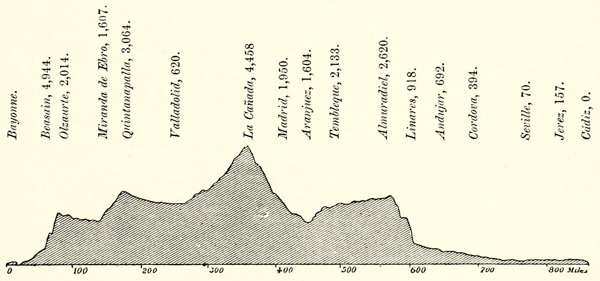
The average height of the mountains separating the basin of the Duero from that of the Tajo is more than that of those in the north-east of Old Castile. The mountains gradually increase in height towards the west and south-west, until they form the famous Sierra de Guadarrama, the granitic rocks of which bound the horizon of Madrid in the north. It constitutes a veritable wall between the two {380} Castiles, and the construction of the roads which lead in zigzag over its passes of Somosierra (4,680 feet), Navacerrada (5,834 feet), and Guadarrama (5,030 feet) was attended with difficulties so considerable that Ferdinand VI., proud of the achievement, placed the statue of a lion upon one of the highest summits, and thus recorded that the “King had conquered the mountains.” This sierra forms a natural rampart to the north of the plains of Madrid, and many sanguinary battles have been fought to secure a passage through them. The railway to Madrid avoids them, but the depression of Ávila, through which it passes, is nevertheless more elevated than the summit of the Mont Cenis Railway.
Μ
Fig. 140.—SIERRAS DE GREDOS AND DE GATA.
Scale 1 : 800,000.
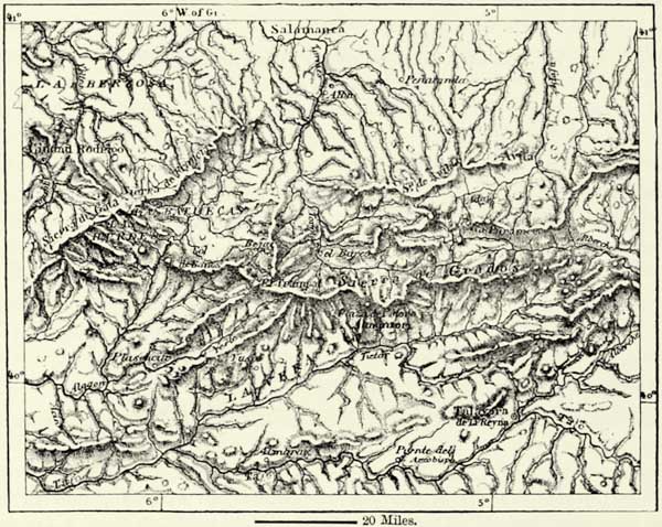
The mountains to the south-west of the Peak of Peñalara (7,870 feet), which is the culminating point of the sierra, sink down rapidly, and at the Alto de la Cierva (6,027 feet) the chain divides into two branches, of which the northern forms the water-shed between the Duero and the Tajo, whilst the more elevated southern chain joins the Sierra de Guadarrama to the Sierra de Gredos, but is cut in two by the defile excavated by the river Alberche, which rises to the north of it.
The Sierra de Gredos is, next to the Pyrenees and the Sierra Nevada of Granada, the most elevated mountain chain of Spain, for in the Plaza del Moro Almanzor it attains a height of 8,680 feet, and thus reaches far beyond the zone of trees. Its naked summits of crystalline rocks remain covered with snow during more than half the year. The country extending along the southern slope {381} of these mountains is one of the most delightful districts of all Spain. It abounds in streams of sparkling water; groups of trees are dotted over the hill-slopes and shield the villages; and Charles V., when he selected the monastery of St. Yuste as the spot where he proposed to pass the remainder of his days, exhibited no mean taste. In former times the foot of the sierra was much more frequented, for the Roman road known as Via Lata (now called Camino de la Plata) crossed immediately to the west of it, by the Puerto de Baños, and thus joined the valley of the Duero to that of the Tajo.
The Sierra de Gata, which lies beyond this old road, has a course parallel with that of the Sierra de Gredos, and this parallelism is observable likewise with respect to the minor chains and the principal river beds of that portion of Spain. The Sierra de Gata rises to a height of 5,690 feet in the Peña de Francia, thus named after a chapel built by a Frankish knight. Within its recesses are the secluded valleys of Las Batuecas and Las Hurdes.
In the eastern portion of New Castile the country is for the most part undulating rather than mountainous, and, if the deep gorges excavated by the rivers were to be filled up, would present almost the appearance of plains. The most elevated point of this portion of the country is the Muela de San Juan (5,900 feet), in the Montes Universales, thus called, perhaps, because the Tajo, the Júcar, the Guadalaviar, and other rivers flowing in opposite directions take their rise there.
The Sierra del Tremendal, in the district of Albarracin, farther north, is said to be frequently shaken by earthquakes, and sulphurous gases escape there where oolitic rocks are in contact with black porphyry and basalt. Several triassic hills in the vicinity of Cuenca are remarkable on account of their rock-salt, the principal mines of which are those of Minglanilla.
Farther south the height of land which separates the rivers flowing to the Mediterranean from those tributary to the Tajo and Guadiana is undulating, but not mountainous. We only again meet with real mountains on reaching the head-waters of the Guadiana, Segura, and Guadalimar, where the Sierra Morena, forming for 250 miles the natural boundary between La Mancha and Andalusia, takes its rise. Seen from the plateau, this sierra has the appearance of hills of moderate height, but travellers facing it from the south see before them a veritable mountain range of bold profile, and abounding in valleys and wild gorges. Geographically this sierra belongs to Andalusia rather than to the plateau of the Castiles.
In the west, judging from the courses of the Tajo and the Guadiana, the country would appear to subside by degrees into the plains of Portugal; but such is not the case. The greater portion of Estremadura is occupied by a mountain mass consisting of granite and other crystalline rocks. The sedimentary strata of the region bounded in the north by the Sierras of Gredos and Gata, and in the south by the Sierra de Aroche, are but of small thickness. In former times these granitic mountains of Estremadura retained pent-up waters of the lakes which then covered the interior plateaux, until the incessant action of water forced a passage through them. Their highest summits form a range between the rivers Guadiana and Tajo known as the Sierra of Toledo, and attain a height of 5,115 feet in {382} the Sierra de Guadalupe, famous in other days on account of the image of a miracle-working Virgin Mary, an object of veneration to Estremeños and Christianized American Indians.
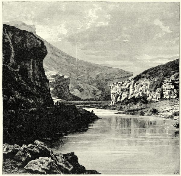
Fig. 141.—DEFILE OF THE TAJO IN THE PROVINCE OF GUADALAJARA.
Geologically the series of volcanic hills known as Campo de Calatrava (2,270 feet) constitute a distinct group. They occupy both banks of the Guadiana, and the ancient inland lake now converted into the plain of La Mancha washed their foot. From their craters were ejected trachytic and basaltic lavas, as well as ashes, or negrizales, but acidulous thermal springs are at present the only evidence of subterranean activity.
The rivers of the Castiles are of less importance than might be supposed from a look at a map, for, owing to a paucity of rain, they are not navigable. The moisture carried eastward by the winds is for the most part precipitated upon the {383} exterior slopes of the mountains, only a small proportion reaching the Castilian plateaux. Evaporation, moreover, proceeds there very rapidly, and if it were not for springs supplied by the rains of winter there would not be a single perennial river.138
Of the three parallel rivers, the Duero, the Tajo, and the Guadiana, the latter two are the most feeble, for the supplementary ranges of the Sierras of Gredos and Guadarrama shut off their basins from the moisture-laden winds of the Atlantic. Yet, in spite of their small volume, the geological work performed by them in past ages was stupendous. Both find their way through tortuous gorges of immense depth from the edge of the plateaux down to the plains of Lusitania. The gorge of the Duero forms an appropriate natural boundary between Spain and Portugal, for it offers almost insurmountable obstacles to intercommunication. The more considerable tributaries of the Duero—such as the Tormes, fed by the snows of the Sierra de Gredos; the Yéltes; and the Agueda—likewise take their course through wild defiles, which may be likened to the cañons of the New World. The Tajo presents similar features, and below its confluence with the Alberche it enters a deep defile, hemmed in by precipitous walls of granite.
The Guadiana passes through a similar gorge, but only after it has reached the soil of Portugal. The hydrography of its head-streams, the Giguela and Záncara, which rise in the Serranio of Cuenca, offers curious features; but, as they are for the most part dry during summer, the bountiful springs known as the ojos, or “eyes,” of the Guadiana are looked upon by the inhabitants as the true source of the river. They are three in number, and yield about four cubic yards of water a second. These springs are popularly believed to be fed by the Ruidera, which, after having traversed a chain of picturesque lakelets, disappears beneath a bed of pebbles; but Coello has shown that after heavy rains this head-stream of the Guadiana actually reaches the Záncara.
The climate of the Castilian plateaux is quite continental in its character. The prevailing winds of Spain are the same as in the rest of Western Europe, but the seasons and sudden changes of temperature in the upper basins of the Duero, the Tajo, and the Guadiana recall the deserts of Africa and Asia. The cold in winter is most severe, the heat of summer scorching, and the predominating winds aggravate these features. In winter, the norte, which passes across the snow-covered Pyrenees and other mountain ranges, sweeps the plains and penetrates through every crevice in the wretched hovels of the peasants. In summer a contrary wind, the solano, penetrates through breaks in the Sierra Nevada and Sierra Morena, scorches the vegetation, and irritates man and animals. The climate of Madrid139 is typical of that of most of the towns of Castile. The air, though pure, is exceedingly dry and penetrating, and persons affected with diseases of the throat run considerable risk during their period of acclimation. “The air of Madrid does not put out a candle, but kills a man,” says a proverb, and the climate of that city is described as “three months of winter and nine of hell.” True, in the {384} time of Charles V., Madrid enjoyed the reputation of having an excellent climate, and it is just possible that its deterioration may be ascribable to the destruction of the forests.
Μ
Fig. 142.—THE STEPPES OF NEW CASTILE.
According to Willkomm. Scale 1 : 1,500,000.
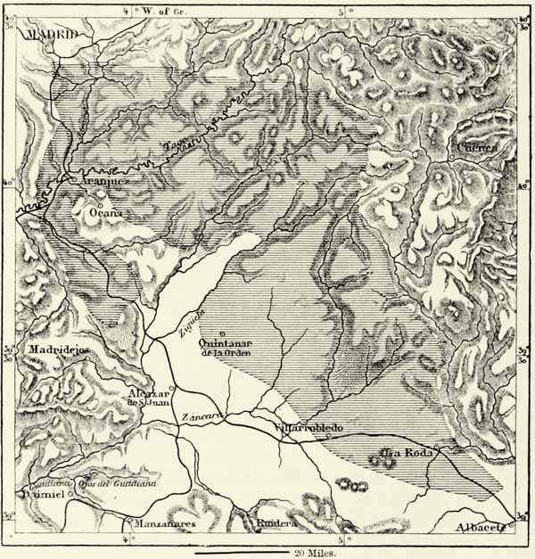
The greatest variety of plants is met with if we ascend from the plains to the summits of the mountains, but taken as a whole the vegetation is singularly monotonous, for the number of plants capable of supporting such extremes of temperature is naturally limited. Herbs and shrubs predominate. The thickets in the upper basin of the Duero and on the plateaux to the east of the Tajo and the Guadiana consist of thyme, lavender, rosemary, hyssop, and other aromatic plants; on the southern slopes of the Cantabrian Mountains heaths with small pink flowers predominate; vast areas in the mountains of Cuenca are covered with Spanish broom, or esparto; and saline plants abound in the environs of Albacete. These regions are generally described as the “Steppes of Castile,” though “deserts” {385} would, perhaps, be a more appropriate term. For miles around the village of San Clemente not a rivulet, a spring, or a tree is met with, and the aspect of the country throughout is exceedingly dreary. The interminable plains of La Mancha—the “dried-up country” of the Arabs—adjoin these steppes in the west, and there corn-fields, vineyards, and pasture-grounds alternate with stretches of thistles, and the monotony is partly relieved by the windmills, with their huge sweeps slowly revolving overhead. Estremadura and the slopes of the Sierra Morena are principally covered with rock-roses, and from the summit of some hills a carpet of jarales, bluish green or brown, according to the season, extends as far as the eye reaches, and in spring is covered with an abundance of white flowers resembling newly fallen snow.
Woods are met with only on the slopes of the mountains. Oaks of various species and chestnut-trees occupy the lower zone, and conifers extend beyond them to the extreme limit of trees. These latter likewise cover the vast tracts of shifting sands which extend along the northern foot of the Sierra de Guadarrama, and are the analogue of the French landes.
The remains of the ancient forests still shelter wild animals. In the beginning of this century bears were numerous on the southern slopes of the Cantabrian Mountains; the thickets of Guadarrama, Gredos, and Gata still harbour wolves, lynxes, wild cats, foxes, and even wild goats. Deer, hares, and other game abound. The oak forests are haunted by wild boars of immense size and strength. Before the downfall of Islam it was thought meritorious to keep large herds of pigs, and a traveller who visits the remote villages of Leon, Valladolid, and Upper Estremadura will find that this ancient custom still survives. The black hogs of Trujillo and Montanchez are famous throughout Spain for their excellent hams.
The country offers great facilities for the breeding of sheep and cattle; there are, however, several districts which are admirably suited to the production of cereals. The Tierra de Campos, in the basin of the Duero, is one of them. It owes its fertility to a subterranean reservoir of water, as do also the mesa of Ocaña and other districts in the upper basins of the Tajo and the Guadiana, which are arid only in appearance. The vine flourishes on stony soil, and yields excellent wine, and the same may be said of the olive-tree, which constitutes the wealth of the Campo de Calatrava. Agricultural pursuits would thus appear to offer great advantages; and if thousands of acres are still allowed to lie fallow, if nomad habits still predominate, this is owing to sloth, force of habit, the existence of feudal customs, and sometimes, perhaps, to discouragement produced by seasons of drought.
Most of the herds of merinos are obliged to traverse nearly half Spain in search of the food they require. Each herd of about 10,000 sheep is placed in charge of a mayoral, assisted by rabadanes in charge of detachments of from 1,000 to 1,200 animals. The shepherds and sheep of Balia, in Leon, are reputed to be the best. In the beginning of April the merinos leave their pasture-grounds in Andalusia, La Mancha, and Estremadura for the north, where they pass the summer, returning in September to the south. It may readily be imagined that {386} these wandering herds do much damage to the fields through which they pass, even though the privileges of the sheep-breeders were abrogated in a large measure in 1836. Spain, however, in spite of every advantage offered by nature, is obliged now to import sheep from abroad to improve its flocks. Mules, too, which are almost indispensable in so stony a country, are imported from France. Camels, llamas, and kangaroos have been introduced, but their number has never been large, and the fauna as well as the flora of the Castiles bears the stamp of monotony.
As is the land, so are its inhabitants. The men of Leon and the Castiles are grave, curt of speech, majestic in their gait, and of even temper. Even in their amusements they carry themselves with dignity, and those amongst them who respect the traditions of the good old time regulate every movement in accordance with a most irksome etiquette. The Castilian is haughty in the extreme, and Yo soy Castellano ! cuts short every further explanation. He recognises no superiors, but treats his fellows on a footing of perfect equality. A foreigner who mixes for the first time in a crowd at Madrid or elsewhere in the Castiles cannot fail of being struck by the natural freedom with which rich and poor converse with each other.
The Castilian, thanks to his tenacious courage and the central position he occupies, has become the master of Spain, but he can hardly be said to be the master in his own capital. Madrid is the great centre of attraction of the entire peninsula, and its streets are crowded with provincials from every part of Spain. This invasion of the capital, and of the Castiles generally, is explained by the sparseness of the population of the plateaux, a sparseness not so much due to the natural sterility of the country as to political and social causes. There can be no doubt that the Castiles formerly supported a much denser population than they do now, but the towns of the valleys of the Tajo and the Guadiana have shrunk into villages, and the river, which was formerly navigable as far as Toledo, is so no longer, either because its volume is less now than it used to be, or because its floods are no longer regulated. Estremadura, at present one of the poorest provinces of Spain, supported a dense population in the time of the Romans, who founded there the Colonia Augusta Emerita (Mérida), which became the largest town of Iberia. During the dominion of the Moors, too, Estremadura yielded bounteous harvests, but the old cities have disappeared, and the fields are now covered with furze, broom, and rock-roses.
The expulsion of the Moors no doubt contributed towards the decay of these once fertile regions, but the principal cause must be looked for in the growth of feudal, military and ecclesiastical institutions, which robbed the cultivator of the fruits of his labours. Subsequently, when Cortes, Pizarro, and other conquistadores performed their prodigious exploits in the New World, they attracted the enterprising youth of the province. The peaceable cultivation of the soil was held in contempt, fields remained untilled, and 40,000 nomadic shepherds took possession of the country. It is thus the Estremeños became what they are, the “Indians” of the nation. {387}
This decrease of population was unfortunately attended by a return towards barbarism. Three hundred years ago the region on the southern slopes of the Sierra de Guadarrama was famous for its industry. The linen and cloth of Ávila, Medina del Campo, and Segovia were known throughout Europe; Burgos and Aranda del Duero were the seats of commerce and industry; and Medina de Rio Seco was known as “Little India,” on account of the wealth displayed at its fairs. But misgovernment led to the downfall of these industries, the country became depopulated, and its ancient culture dwindled to a thing of the past. At the famous university of Salamanca the great discoveries of Newton and Harvey were still ignored at the close of last century as being “contrary to revealed religion,” and the lower classes grovelled in the most beastly superstitions.
In this very province of Salamanca, close to the Peña de Francia, exist the “barbarous” Batuecas, who are charged with not being able to distinguish the seasons. Nor are the inhabitants of other remote mountain districts of the Castiles what we should call civilised. Amongst these may be noticed the charros of Salamanca and the famous maragatos of Astorga, most of them muleteers. They only intermarry amongst themselves, and are looked upon as the lineal descendants of some ancient tribe of Iberia. The suggestion that they are a mixed race of Visigoths and Moors is not deserving of attention, for neither in their dress nor in their manners do they remind us of Mussulmans. They wear loose trousers, cloth gaiters fastened below the knee, a short and close-fitting coat, a leather belt, a frill round the neck, and a felt hat with a broad brim. They are tall and strong, but wiry and angular. Their taciturnity is extreme, and they neither laugh nor sing when driving before them their beasts of burden. It is difficult to excite their passion, but, once roused, they become ferocious. Their honesty is above suspicion, and they may be safely trusted with the most valuable goods, which they will defend against every attack, for they are brave, and skilled in the use of arms. Whilst the men traverse the whole of Spain as carriers of merchandise, the women till the soil, which, being arid and rocky, yields but a poor harvest.
The vicissitudes of history explain the existence of numerous towns in the Castiles which can boast of having been the capital of the country at one time or other. Numantia, the most ancient of all those cities, exists no longer, and the learned are not yet agreed whether the ruins discovered near the decayed town of Soria are the remains of the walls demolished by Scipio Æmilianus. But there are several cities of great antiquity which possess some importance even at the present day. Leon is one of these. It was the head-quarters of a Roman legion (septima gemina), and its name, in reality a corruption of legio, is supposed to be symbolized by the lions placed in its coat of arms. Leon was one of the first places of importance taken from the Moors. Its old walls are in ruins now, and the beautiful cathedral has been transformed into a clumsy cube. Astorga, the “magnificent city” of Asturica Augusta, has fallen even lower than Leon, whilst Palencia (the ancient Pallantia) still enjoys a certain measure of prosperity, owing {388} to its favourable geographical position at the Pisuerga, which has caused it to be selected as one of the great railway centres of the peninsula.
Burgos, the former capital of Old Castile, points proudly to its graceful cathedral and other ancient buildings, but its streets are nearly deserted, and the crowds which congregate occasionally in the churches, hotels, or at the railway station are composed, for the most part, of beggars. In the cathedral are preserved numerous relics, and the Cid, whose legendary birthplace, Bivar, is near, lies buried in it.
Μ
Fig. 143.—SALAMANCA AND ITS DESPOBLADOS.
Scale 1 : 200,000.
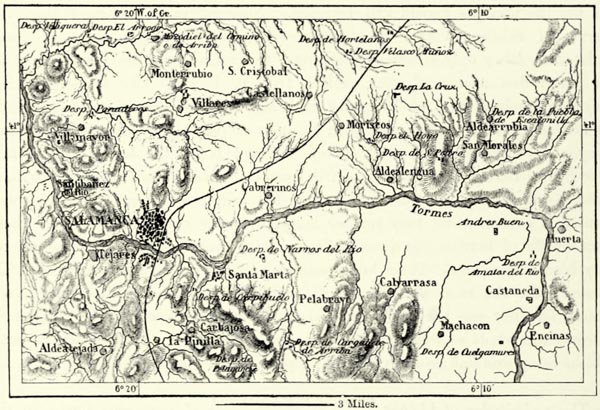
Valladolid, the Belad Walid of the Moors, at one time the capital of all Spain, enjoys a more favourable geographical position than Burgos. It lies on the Lower Pisuerga, where that river enters the broad plain of the Duero, at an elevation of less than 600 feet above the sea. There are numerous factories, conducted by Catalans, and the city boasts, like Burgos, of many curious buildings and historical reminiscences. The houses in which Columbus died and Cervantes was born are still shown, as is the beautiful monastery of San Pablo, in which resided Torquemada, the monk, who condemned 8,000 heretics to die at the stake. The castle of Simancas, where the precious archives of Spain are kept, is near this city.
Descending the Duero, we pass Toro, and then reach Zamora, the “goodly walls” of which proved such an obstacle to the Moors. Zamora, though on the direct line between Oporto and continental Europe, is an out-of-the-way place at {389} present, and the same may be said of the famous city of Salamanca, on the Tormes, to the south of it.
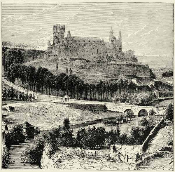
Fig. 144.—THE ALCÁZAR OF SEGOVIA.
Salamanca, the Salmantica of the Romans, succeeded to Palencia as the seat of a university, and during the epoch of the Renaissance was described as the “mother of virtues, sciences, and arts,” and the “Rome of the Castiles.” It still deserves the latter epithet, because of its magnificent bridge built by Trajan, and the beautiful edifices dating back to the fifteenth and sixteenth centuries. Its intellectual superiority, however, is a thing of the past.
Arevalo, and the famous town of Medina del Campo, to the north-east of Salamanca, carry on a considerable trade with corn. Ávila occupies an isolated hillock on the banks of the Adaja, to the north of the Sierra de Gredos. Ávila still preserves its turreted walls of the fifteenth century, and its fortress-like cathedral is a marvel of architecture. There are also curious sculptures of animals, which are ascribed {390} to the aboriginal inhabitants of the country. Similar works of rude art in the vicinity are known as the “bulls of Guisando,” from a village in the Sierra de Gredos.
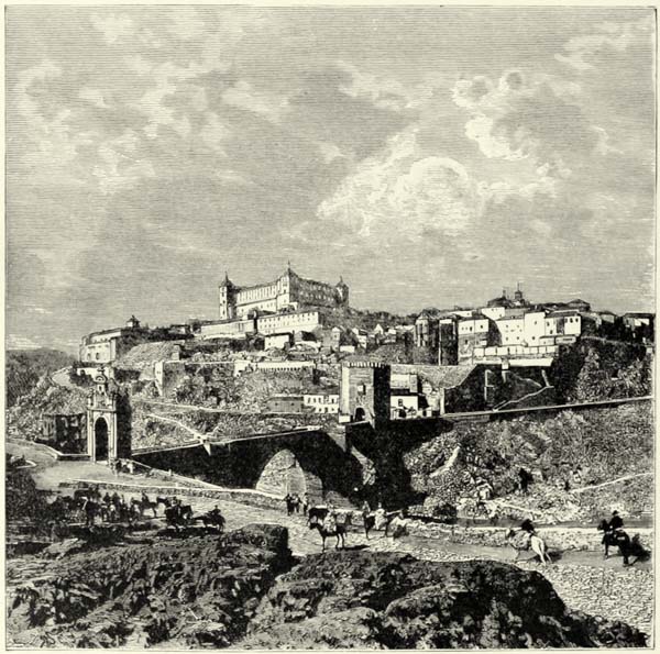
Fig. 145.—TOLEDO.
Segovia the “circumspect” is situated on an affluent of the Duero, like Ávila, and in the immediate vicinity of the Sierra de Guadarrama. Its turreted walls rise on a scarped rock, supposed to resemble a ship. On the poop of this fancied ship, high above the confluence of the Clamores and Eresma, rise the ruins of the Moorish Alcázar, whilst the cathedral, in the centre of the city, is supposed to represent the mainmast. A beautiful aqueduct supplies Segovia with the clear waters of the Guadarrama. It is the finest Roman work of this class in Iberia, and far superior to the royal palace of San Ildefonso or of La Granja, in the neighbourhood of the city.
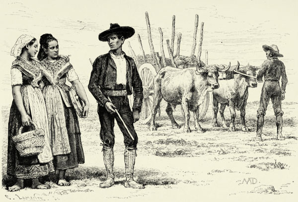
PEASANTS OF TOLEDO, CASTILE.
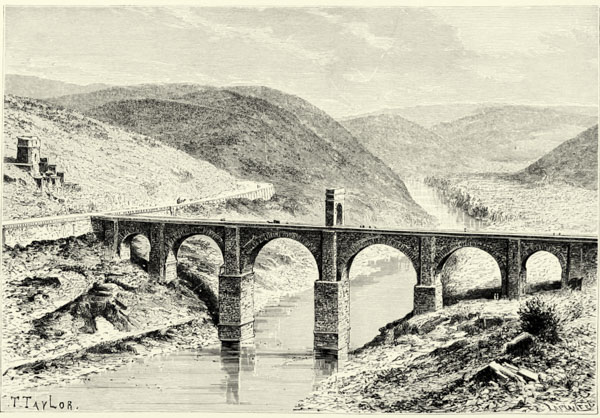
ROMAN BRIDGE AT ALCANTARA.
Toledo is the most famous city to the south of the great rampart formed by the {391} Sierras of Guadarrama, Gredos, and Gata. This is the Ciudad Imperial, the “mother of cities,” the coronet of Spain and the light of the world, as it was called by Juan de Padilla, the most famous of its sons. Tradition tells us that it existed long before Hercules founded Segovia, and, like Rome, it stands upon seven hills. Toledo, with its gates, towers, Moorish and mediæval buildings, is indeed a beautiful city, and its cathedral is of dazzling richness. But, for all this, Toledo is a decayed place, and its famous armourers’ shops have been swamped by a Government manufactory.
Talavera de la Reyna, below Toledo, on the Tajo, still possesses some of its ancient manufactures of silk and faience. Puente del Arzobispo and the other towns on the Tajo are hardly more now than large villages. The bridge of Almaraz crosses the river far away from any populous town, and the old Roman bridge of Alconétar exists no longer. Alcántara,—that is, the bridge,—near the Portuguese frontier, still remains a monument of the architectural skill of the Romans. It was completed in the year 105, in the reign of Trajan, and its architect, Lacer, appears to have been a Spaniard. Its centre is at an elevation of 160 feet above the mean level of the Tajo, the floods of which rise occasionally to the extent of a hundred feet.
All the great towns of Estremadura lie at some distance from the Tajo, and its great volume of water has hitherto hardly been utilised for purposes of irrigation or navigation. On a fertile hill nearly twenty miles to the north of this river, the old town of Plasencia may be seen bounded in the distance by mountains frequently covered with snow. Cáceres is about the same distance to the south, as is also Trujillo, which received such vast wealth from the conquerors of Peru, but is now dependent upon its pigs and herds of cattle.
The position of those towns of Estremadura which lie on the banks of the Guadiuna is more favourable. Badajoz, close to the Spanish frontier, has lost its ancient importance as a fortress since it became a place of commerce on the only railway which as yet joins Spain to Portugal. Mérida, on the same railway, is richer in Roman monuments than any other town of Spain, for there are a triumphal arch, the remains of an aqueduct, an amphitheatre, a naumachy, baths, and an admirable bridge of eighty granite arches, 2,600 feet in length; but in population it is far inferior to Don Benito, a town hardly mentioned in history, higher up the Guadiana, at the edge of the vast plain of La Serena. It was founded in the beginning of the sixteenth century, and together with its neighbour, Villanueva de la Serena, derives its wealth from the fertility of the surrounding country. Its fruits, and particularly its water-melons, are much esteemed. The plains on the right bank of the Guadiana abound in phosphate of lime, which is exported to France and England.
The towns of La Mancha are of no historical note, and the province owes its celebrity almost exclusively to Cervantes’ creation, the incomparable “Don Quixote.” Ciudad Real, an industrious place formerly; Almagro, known for its point-lace; Daimiel, near which stood the principal castle of the military order of Calatrava; Manzanares; and other towns are important principally because of their {392} trade in corn and wine. Almaden,—that is, “the mine,”—in a valley on the northern slope of the Sierra Morena, has become famous through its cinnabar mines, which for more than three centuries supplied the New World with mercury, and still yield about 1,200 tons annually.
Μ
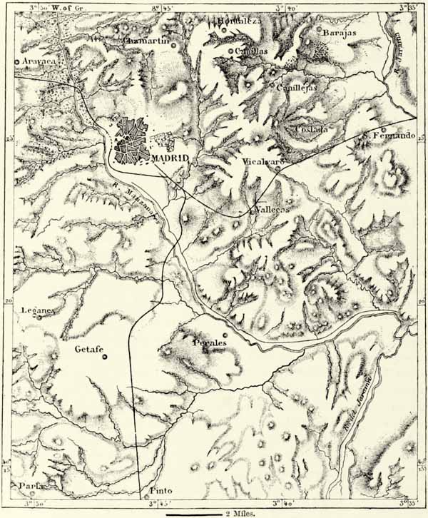
Fig. 146.—MADRID AND ITS ENVIRONS.
Scale 1 : 200,000.
Eastern Castile, being at a considerable elevation above the sea-level, and having a rugged surface, cannot support a population more dense than either La Mancha or Estremadura. There are but few towns of note, and even the capital, Cuenca, is hardly more than a third-rate provincial city. Picturesquely perched {393} upon a steep rock overhanging the deep gorges of the Huecar and Júcar, it merely lives in the past. The only other towns of note in that part of the country are Guadalajara, with a Roman acqueduct, and Alcalá, the native place of Cervantes and seat of an ancient university, which at one time saw 10,000 students within its walls. Both these towns are situated on the Henares, a tributary of the Tajo, and either would have been fit to become the capital of the kingdom.
Indeed, at the first glance, it almost appears as if Madrid owed its existence to the caprice of a king. It has no river, for the Manzanares is merely a torrent, its climate is abominable, and its environs present fewer advantages than those of Toledo, the ancient capital of the Romans and Visigoths. But once having been selected as the capital, Madrid could not fail to rise in importance, for it occupies a central position with respect to all other towns outside the basin of the Upper Tajo. Pinto (Punctum), a short distance to the south of Madrid, is popularly supposed to be the mathematical centre of the peninsula; and thus much is certain, that the plain bounded in the north by the Sierra de Guadarrama forms the natural nucleus of the country, and is traversed by its great natural highways.
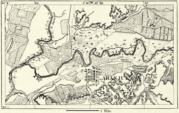
Toledo occupies a position almost equally central. It was the capital of the country during the reign of the Romans, and subsequently became the capital of the ecclesiastical authorities and of the kings of the Visigoths, and retained that position until it fell into the power of the Moors. During the struggles between Moors and Christians the latter shifted their capital from place to place, according to the varying fortunes of the war, but no sooner had the former been expelled from Córdova than the Christian kings again established themselves in the plain to the south of the Sierra de Guadarrama. They had then to choose between Toledo and Madrid. Toledo no doubt offered superior advantages, but its citizens having joined the insurrection of the comuneros against Charles V., the Emperor-king decided in favour of Madrid. Philip III. endeavoured to remove the capital to Valladolid, but the natural attractions of Madrid proved too strong for him, and the schools, museums, public buildings, and manufactories which have arisen in the latter since then must for ever insure it a preponderating position. The railways, which now join Madrid to the extremities of the peninsula, countervail the disadvantages of its immediate neighbourhood; and although the purest Castilian is spoken at Toledo, it is Madrid which, through its press, has insured the preponderance of that idiom throughout Spain. Madrid has long been in advance of all other cities of the peninsula as regards political activity, industry, and commerce, but its growth having taken place during a period devoid of art, it is inferior to other towns with respect to the character of its public buildings. The museums, however, are amongst the richest in Europe, and make it a second Florence. Immediately outside the public promenades of the Prado and Buen Retiro we find ourselves in a desolate country covered with flints, and this must be crossed by a traveller desirous of visiting the delightful gardens of Aranjuez, the huge Escorial built by Philip II., or the villas in the wooded valleys of the Sierra de Guadarrama. These latter supply Madrid with water, as the neighbouring mountains do with ice. Formerly one of the most secluded of these valleys became {394} the seat of a mock-kingdom, nominally independent of the Kings of Castile. During the Moorish invasion the inhabitants of the plain of Jarama had sought shelter in the mountains, and the rest of the world forgot all about them. They called themselves Patones, and elected an hereditary king. About the middle of the seventeenth century the last of the line, by trade a carrier, surrendered his wand of authority into the hands of a royal officer, and the valley was placed under the jurisdiction of the authorities at Uceda.140
III.—ANDALUSIA.*
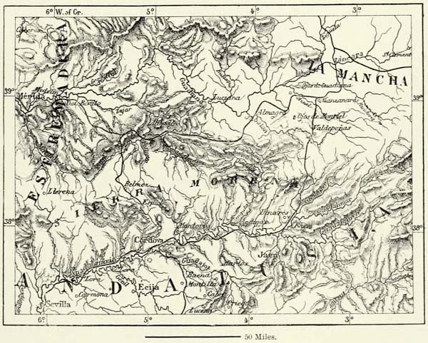
Andalusia embraces the whole of the basin of the Guadalquivir, together with some adjoining districts. It is bounded in the north by the Sierra Morena, which in the direction of Portugal becomes a rugged mountain district of crystalline formation intersected by tortuous ravines, and rising in the Sierra de Aracena, north of the mining region of the Rio Tinto, to a height of 5,500 feet. Farther east the Sierra Morena ascends in terraces above the valley of the Guadalquivir, and on its reverse slope we meet with districts, such as that of Los Pedroches (1,650 feet), hardly less monotonous of aspect than the plains of La Mancha. The {395} Punta de Almenara (5,920 feet), in the Sierra de Alcaraz, in the extreme east, may be looked upon as the culminating point of this sierra, which is indebted for its name of “Black Mountain” to the sombre pines which clothe its slopes.
Μ
Fig. 147.—ARANJUEZ.
Scale 1 : 75,000.
The line of water-parting does not pass through the highest summits of this range. Most of the rivers rise on the plateau, and take their course, by picturesque gorges, right through the heart of the mountains. The most famous of these gorges is that of Despeñaperros (2,444 feet), leading from the dreary plains of La Mancha to the smiling valley of Andalusia. This pass has played a great part in every war. At its foot was fought in 1212 the fearful battle of Navas de Tolosa, in which more than 200,000 Mussulmans are said to have been slaughtered.
Μ
Fig. 148.—THE BASINS OF THE GUADIANA AND GUADALQUIVIR.
Scale 1 : 3,000,000.
The mountains which shut in the basin of Andalusia on the east are cut up by deep river gorges into several distinct masses or chains, of which the Calar del Mundo (5,437 feet), Yelmo de Segura (5,925 feet), and Sierra Sagra (7,675 feet) are the principal. The southern mountain ranges uniformly extend from east to west. From north to south we cross in succession the Sierras de María (6,690 feet), de las Estancias, and de los Filabres (6,283 feet), so famous for its marbles. In the west the latter two ranges join the Sierra de Baza (6,236 feet), itself attached to the great culminating range of Iberia, the Sierra Nevada, by a saddle of inconsiderable height (2,950 feet). {396}
The Sierra Nevada consists mainly of schists, through which eruptions of serpentine and porphyry have taken place. The area it occupies is small, but from whatever side we approach it rises precipitously, and the eye can trace the succeeding zones of vegetation up to that of perennial snows pierced by the peaks of Mulahacen (11,661 feet), Picacho de la Veleta (11,386 feet), and Alcazaba (7,590 feet). Vines and olive-trees clothe the foot-hills; to these succeed walnut-trees, then oaks, and finally a pale carpet of turf hidden beneath snow for six months. Masses of snow accumulate in sheltered hollows, and these ventisqueros, ventiscas, or snow-drifts, supply Granada with ice. In the Corral de la Veleta there even exists a true glacier, which gives birth to the river Genil, and is the most southerly in all Europe. The more extensive glaciers of a former age have disappeared long ago. To the purling streams fed by the snows of the sierra the Vega of Granada owes its rich verdure, its flowers, and its excellent fruits, and the delightful valley of Lecrin its epithet of “Paradise of the Alpujarras.”
Fig. 149.—THE PASS OF DESPEÑAPERROS.
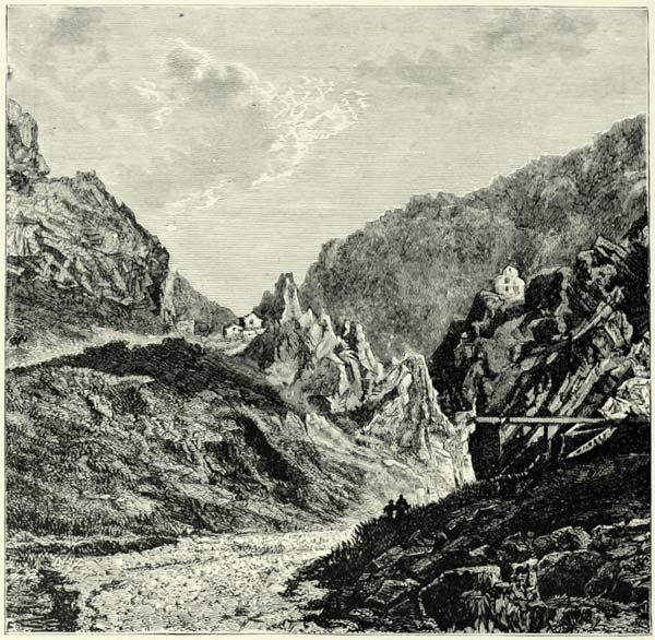
{397}
No other district of Spain so forcibly reminds us of the dominion of the Moors. The principal summit is named after a Moorish prince. On the Picacho they lit a beacon on the approach of a Christian army, and in the Alpujarras, on the southern slope, they pastured their sheep. The Galician and Asturian peasants, who now occupy this district, are superior in no respect to the converted Moors who were permitted to remain at Ujijar, the capital of Alpujarras, when their compatriots were driven forth. The natural riches of the mountains remain undeveloped, and they are surrounded by a belt of despoblados.
Fig. 150.—THE SIERRA NEVADA AS SEEN FROM BAZA.
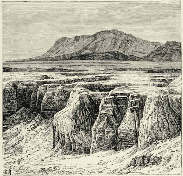
From the Pass of Alhedin (3,300 feet), between Granada and Alpujarra, we look down upon one of the most charming panoramas of the world. It was here that Boabdil, the fugitive Moorish king, beheld for the last time the smiling plains of his kingdom, and hence the spot is known as the “Last Sigh of the Moor,” or the “Hill of Tears.” From the highest summits of the sierra, however, the prospect is exceedingly grand. Standing upon the Picacho de la Veleta, we see Southern {398} Spain spread out beneath our feet, with its fertile valleys, rugged rocks, and russet-coloured wilds. Looking south, across the blue waters of the Mediterranean, the mountains of Barbary loom out in the distance, and sometimes we are even able to hear the murmuring of the waves as they beat against the coast.
The mountains around these giants of Granada are very inferior to them in height. The country in the north, which is bounded by the valleys of the Genil, Guadiana Menor, and Guadalquivir, is occupied by an upland intersected by deep ravines, and rising now and then into distinct mountain chains, such as the Sierra Magina (7,047 feet) and Sierra de Jabalcuz, near Jaen (1,800 feet); the chain Alta Coloma, farther south, with its wild pass, Puerto de Arenas, between Jaen and Granada; and the Sierra Susana, close to Granada, which extends westward to the mountain mass of the Parapanda, the great prophet of the husbandmen of the Vega:―
“Cuando Parapanda se pone la montera,
Llueve, aunque Dios no lo quisiera.”
(“When Parapanda puts on his cap it rains, though God may not wish it.”)
The mountains extending along the coast are cut up by transverse valleys into several distinct masses. The Sierra de Gata, in the south-east, is a detached mountain mass, pierced by several extinct volcanoes. Farther west rises the Sierra Alhamilla, the torrents of which are so rich in garnets that the huntsmen use them instead of shot. Crossing a rivulet, we reach the superb Sierra de Gádor (7,620 feet), consisting of schists.
The Contraviesa (6,218 feet), which separates the Alpujarras from the Mediterranean, rises so steeply from the coast that even sheep can hardly climb it. The Sierra de Almijara, beyond the narrow valley of the Guadalfeo, and its western continuation, the Sierra de Alhama (7,003 feet), present similar features. The mountains on the other side of the Pass of Alfarnate or de los Alazores (2,723 feet) constitute the exterior rampart of an ancient lake bed, bounded in the north by an irregular swelling of ground known as Sierra de Yeguas. The road from Málaga to Antequera crosses that rampart in the famous Pass of El Torcal (4,213 feet), the fantastically shaped rocks of which bear some resemblance to the ruins of an extensive city. Archæologists have discovered there some of the most curious prehistoric remains of Iberia.
To the west of the basin of Málaga, drained by the Guadalhorce, the emissary of the ancient lake referred to above, the mountains again increase in height, and in the Sierra de Tolox attain an elevation of 6,430 feet. Snows remain here throughout the winter. From the Tolox mountain chains ramify in all directions. The Sierra Bermeja (4,756 feet) extends to the south-west, its steep promontories being washed by the waves of the sea; the wild “Serrania” de Ronda (5,085 feet) extends westward, and is continued in the mountain mass of San Cristóbal (5,627 feet), which sends branches southward as far as the Capes of Trafalgar and Tarifa. The rock of Gibraltar (1,408 feet), which rises so proudly at the entrance of the Mediterranean, is a geological outlier attached to the mainland by a strip of sand thrown up by the waves of the ocean.
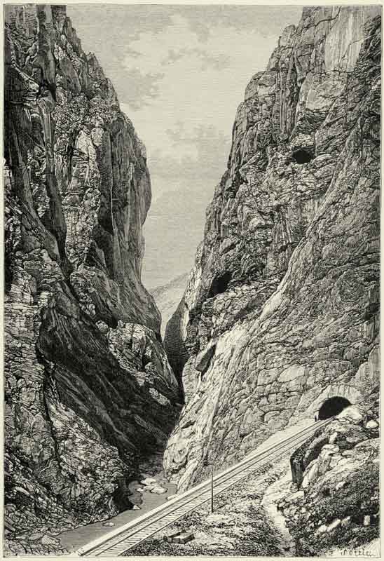
GORGE DE LOS GAITANES, DEFILE OF GUADALHORCE.
Μ
Fig. 151.—THE MOUTH OF THE GUADALQUIVIR.
Scale 1 : 200,000.
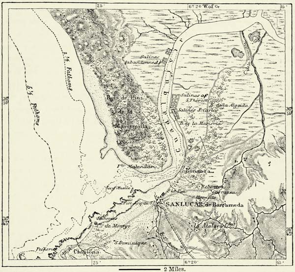
{399}
Erosion has powerfully affected the mountains occupying the country between the basin of the Guadalquivir and the coast. Amongst the numerous river gorges, that of the Gaytanos, through which the Guadalhorce flows from the plateau of Antequera to the orange groves of Alora, is one of the wildest and most magnificent in all Spain. Only torrents enter the Mediterranean, and even of the rivers discharging their waters into the Atlantic there is but one which is of some importance, on account of its great volume and the facilities it offers for navigation. This is the Guadalquivir, which rises in the Sierra Sagra, at an elevation of 5,900 feet above the sea-level. Having received the Guadalimar, its current becomes gentle, and it flows through a wide and open valley, thus differing essentially from the rivers of the Castiles, which, on their way to the sea, traverse narrow gorges. Its volume fairly entitles it to its Arab name of Wad-el-Kebir, or “large river.” The geological work performed by this river and its tributaries has been enormous. Mountain ramparts have been broken through, lakes drained, and immense quantities of soil spread over the valley. Nowhere can this work be traced more advantageously than in the valley of the Genil of Granada, for the fertile district of La Vega was covered by a lake, the pent-up waters of which opened themselves a passage near Loja. {400}
The estuary of the river has been gradually filled up by sediment. The tide ascends nearly as far as Seville, where the river is about 250 yards wide. Below that city it passes through an alluvial tract known as the marismas, ordinarily a dusty plain roamed over by half-wild cattle, but converted by the least rain into a quagmire. Neither villages nor homesteads are met with here, but the sands farther back are covered with dwarf palms, and lower down a few hills of tertiary formation approach close to the river, their vine-clad slopes affording a pleasing contrast to the surrounding solitude.
A contraction of the alluvial valley marks the exterior limit of the ancient estuary silted up by the Guadalquivir. Sanlúcar de Barrameda, a town of oriental aspect, stands on the left bank, whilst a range of dunes intervenes between the sea and the flat country on the right bank. The mouth of the river is closed by a bar, so that only vessels of small draught can enter it. These Arenas Gordas, or “great sands,” are for the most part covered with pines, and, except on their exterior face, they have remained stable since the historical epoch.
The Guadalquivir is the only river of Spain which is navigable for a considerable distance above its mouth. Vessels of 200 tons ascend it as far as Seville, a distance of sixty miles. Sanlúcar was formerly the great port of Spain, and its coasting trade is still considerable. None of the other rivers of Andalusia are navigable. The Guadalete, which enters the Bay of Cádiz, is a shallow, sluggish stream; the Odiel and the Rio Tinto are rapid torrents, and their estuary, below Huelva, has been choked up by the sediment brought down by them; while Palos, so famous as the port from which Columbus started upon his great voyage of discovery, has dwindled down to a poor fishing village.
But what are these changes compared with the great revolution which joined the Mediterranean to the Atlantic? There can be no doubt that a barrier of mountains separated the two seas. The destructive action of the Atlantic appears to have been facilitated not only by the cavernous nature of the rocks on both sides of the strait, but also by the fact of the level of the Mediterranean having been much lower at that time than that of the Atlantic. Even now the waters of the latter sometimes rush through the strait with astounding velocity (see Fig. 6, p. 26). We cannot tell whether the strait has increased in width during historical times, for ancient geographers are not very precise in their measurements. Thus much, however, is certain, that the general features of the strait have not changed, and the two pillars of Hercules, Calpe and Abyla, may still be recognised in modern Gibraltar and Ceuta.
The rock of Gibraltar does not form the southernmost promontory of Iberia, but, being the most striking object along the strait, it has given its name to it. Mariners look upon it as the true boundary between the Mediterranean and the Atlantic, and it has been likened, not inaptly, to a crouching lion guarding the gateway between the two seas. It rises almost perpendicularly on the east, and the town, with most of the batteries, has been constructed on the western slope, which is more accessible. The famous rock, though a natural dependency of Spain, has become, by right of conquest, one of the great strongholds of England, and its {401} importance as a fortress as well as a place of commerce is indisputable. In its caverns have been discovered stone implements and the skeletons of dolichocephalous men.
The frequent intercourse between Andalusia and the Berber countries on the other side of the strait is explained by vicinity as well as by similarity of climate. Algarve, Huelva, and the lower valley of the Guadalquivir, as far as Seville and Écija, that “stewing-pan” or “furnace” of Spain, form one of the hottest districts of Europe, and the coast, from Algeciras and Gibraltar to Cartagena, Alicante, and the Cabo de la Nao, is hardly inferior to it. The country around the Bay of Cádiz and the hilly districts in the extreme south, which are freely exposed to the virazon, or sea breeze, enjoy a more temperate climate. In the two torrid coast regions delineated above frosts are hardly known, and the mean temperature of the coolest month reaches 54° F. The heat is greatest around the bays exposed to the full influence of the hot African winds, and least on the Atlantic seaboard, where westerly breezes moderate it. Contrary atmospheric currents naturally meet in the Strait of Gibraltar, where the wind is generally high, and tempests are frequent in winter. Westerly winds prevail during winter, easterly winds in summer. The two promontories of Europe and Africa are looked upon by mariners as trustworthy signallers of the weather: when they are wrapped in clouds or mists rain and easterly winds may be looked for, but when their profiles stand out clearly against the blue sky it is a sure sign of fine weather and westerly winds.142
The dry and semi-tropical climate of Lower Andalusia frequently exercises a most depressing influence upon Northern Europeans. In the plain and along the coast it hardly ever rains during summer, and the heat is sometimes stifling, for the trade winds of the tropics are unknown. At Cadiz the land wind blowing from the direction of Medina Sidonia, and hence known as medina, is suffocating, and quarrels and even murders are said to occur most frequently whilst it lasts. But the most dreaded wind is the solano or levante, which is hot as the blast from a furnace. A curious vapour, known as calina, then appears on the southern horizon, the air is filled with dust, leaves wither, and sometimes birds drop in their flight as if suffocated.
In the temperate regions of Europe summer is the season of flowers and foliage, but in Andalusia it is that of aridity and death. Except in gardens and irrigated fields all vegetation shrivels up and assumes a greyish tint like that of the soil. But when the equinoctial autumn rains fall in the lowlands, and snows in the mountains, the plants recover rapidly, and a second spring begins. In February vegetation is most luxuriant, but after March heat and dryness again become the order of the day. Indeed, Andalusia suffers from a want of moisture. There are steppes without water, trees, or human habitations, the most extensive being on {402} the Lower Genil, where the depressions are occupied by salt lakes, as in Algeria or Persia, and cultivation is impossible. Another steppe of some extent stretches to the east of Jaen, and is known as that of Mancha Real. The barren tracts on the Mediterranean slopes are relatively even of greater extent than those in the basin of the Guadalquivir. The volcanic region of the Sierra de Gata is a complete desert, where castles and towers erected for purposes of defence are the only buildings. Elsewhere the coast is occupied by saline plains, which support a vegetation mainly consisting of salsolaceæ, plumbagineæ, and cruciferæ, five per cent. of the species of which are African. Barilla, the ashes of which are used in the manufacture of soda, grows plentifully there.
Μ
Fig. 152.—THE STEPPES OF ECIJA.
Scale 1 : 750,000.
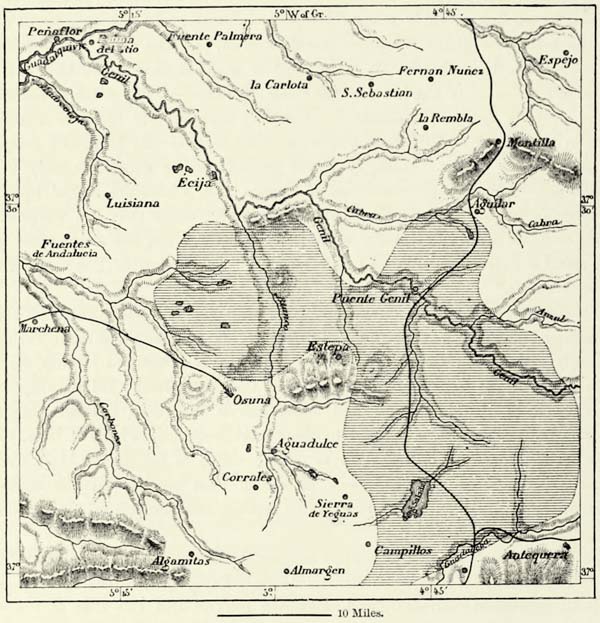
In the popular mind, however, Andalusia has at all times been associated with fertility. Its name recalls the oranges of Seville, the luxuriant vegetation of the Vega of Granada, the “Elysian Fields,” and the “Garden of the Hesperides,” which the ancients identified with the valley of the Bætis. The indigenous flora entitles Andalusia to its epithet of the “Indies of Spain,” and, in addition to {403} the tropical plants from Asia and Africa which grow there spontaneously, we meet with others which have been successfully acclimatized. Dates, bananas, and bamboos grow side by side with caoutchouc-trees, dragon’s-blood trees, magnolias, chirimoyas, erythrinas, azedarachs; ricinus and stramonium shoot up into veritable trees; the cochineal cactus of the Canaries and the ground-nut of the Senegal do well; sweet potatoes, cotton, and coffee are cultivated with success; and the sugar-cane succeeds in sheltered places. The coast between Motril and Málaga is supposed to yield annually £20,000 worth of sugar.
Μ
Fig. 153.—ZONES OF VEGETATION ON THE COAST OF ANDALUSIA.
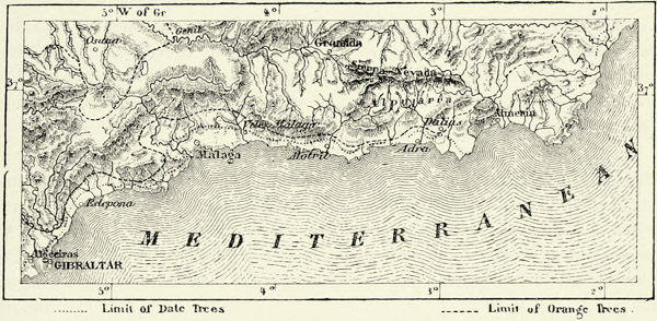
The fauna of Andalusia presents, also, some African features. The molluscs met with in Morocco exist likewise in Andalusia; the ichneumon may be seen on the right bank of the Lower Guadalquivir and elsewhere; the chameleon is plentiful; and a species of wild goat is said to be common to the mountains of Morocco and the Sierra Nevada. Nor should we forget to state that an African monkey (Inuus sylvanus) still lives on the rock of Gibraltar, but whether he has been imported has not yet been determined.
In the dawn of European history Andalusia was probably inhabited by an Iberian race akin to that of the Basques. The Bastulæ, Bastarnæ, and Bastesæ, in the hills facing the Mediterranean, and the Turdetani and Turduli of the valley of the Bætis, bore Euskarian names, as did many of their towns. But even thus early they must have been a mixed race. Celtic tribes held the hills extending to the north-west of the Bætis, in the direction of Lusitania; the Turdetani, who were relatively civilised, for they possessed written laws, permitted Phœnicians, Carthaginians, and Greeks to settle amongst them, and in the end became thoroughly Latinised. Municipal charters discovered at Málaga, and more recently at Osuna (Colonia Julia Genitiva), prove that the cities of this province enjoyed a considerable degree of self-government.
When the Roman world broke down, Southern Spain was invaded by Vandals, {404} Byzantines, and Visigoths, to whom succeeded Arabs, Berbers, and Jews. The influence exercised upon the country by the Moors—that is, by a mixed race of Arabs and Berbers—has been more abiding than that of their Teutonic predecessors. They maintained themselves for more than seven centuries, were numerous in the towns, and cultivated the fields conjointly with the ancient inhabitants of the country. When the order of exile went forth against their whole race, Moorish blood circulated in the veins of those who were charged with the execution of this harsh measure. In certain portions of Andalusia, and more especially in the Alpujarras, where the Moors maintained their independence until the end of the sixteenth century, the mixture between the two races had made such progress that religious profession, and not the colour of the skin, decided nationality. Numerous Arabic words and phrases have found their way into the Andalusian dialect, and the geographical nomenclature of many districts is Arabic rather than Iberian or Latin. Most of the large buildings in the towns are alcázars, or mosques, and even the style of modern structures is Arabic, modified to some extent by Roman influences. The houses, instead of looking upon the street, face an interior court, or patio, where the members of the family meet by the side of a cool fountain. No further ethnical element has been added to the population since the epoch of the Arabs, for the few German colonists who settled at Carolina, Carlota, and elsewhere did not prosper, and either returned to their native country or became merged in the general population.
The Andalusians have frequently been called the Gascons of Spain. They are generally of graceful and supple build, of seductive manners, and full of eloquence, but the latter is too frequently wasted upon trifles. Though not devoid of bravery, the Andalusian is a great boaster, and his vanity often causes him to pass the bounds of truth. At the same time he is of a contented mind, and does not allow poverty to affect his spirit. The mountaineers differ in some respects from the dwellers in the plains. They are more reserved in their manners, and the Jaetanos, or mountaineers of Jaen, are known as the Galicians of Andalusia. The beauty of the highland women is of a more severe type, and, compared with the charming Gaditanes and the fascinating majas of Seville, the women of Granada, Guadix, and Baza are remarkable for an air of haughty nobleness.
No doubt there are men in Bætica who work, but as a rule love of labour is not amongst the virtues of the Andalusian. The country might become the great tropical storehouse of Europe, but its immense resources remain undeveloped. To some extent this is explained by the fact that nearly the whole country is owned by great landlords. Many estates, which formerly were carefully cultivated, have been converted into sheep-walks, and for miles we meet neither houses nor human beings. The highlands, too, belong to large proprietors, but are leased to small farmers, who pay one-third of their product in lieu of rent.
The magnificent orange groves of Seville, Sanlúcar, and other towns, the olive groves, vineyards, and orchards of Málaga, supply the world with vast quantities of fruit; its productive corn-fields have made Andalusia one of the great granaries of the world; but it is mainly its wines which enable it to take a share in {405} international commerce. Immense quantities of the wine known as sherry are grown in the vineyards of Jerez, to the east of Cádiz. Many of the vineyards belong to Englishmen, and merchants of that nation are busily occupied in blending and other operations peculiar to their trade. Several wines, however, maintain their superior character to the present time. Such are the sweet tintilla of Rota, manzanilla, and pajarate, made from dried grapes. In spite of many malpractices, this branch of industry has exercised a most beneficial influence upon the character of the population. Santa María, on the Bay of Cádiz, is one of the great wine ports of the world, and Spain has become a formidable rival of its northern neighbour.143
The ancient manufacturing industry of the country can hardly be said to exist any longer, but mining is still carried on. Strabo exaggerates the mineral wealth of the country, which is nevertheless very great. Nearly all the productive mining districts of Southern Spain are in the hills. The Sierra de Gádor is said to contain “more metal than rock.” Hundreds of argentiferous lead, copper, and iron mines have been opened there, and in the sierras of Guadix, Baza, and Almería. Near Linares, on the Upper Guadalquivir, there are lead mines yielding about 210,000 tons annually. The silver mines of Constantina and Guadalcanal, in the Sierra Morena, are being worked only at intervals. The coal basins of Bélmez and Espiel, to the north of Córdova, promise to become of great importance, although the output at present hardly exceeds 200,000 tons a year. Deposits of iron and copper exist near them.
But of all the mines of Spain those situated in the province of Huelva are the most productive. The Silurian rocks there are wonderfully rich in pyrites of copper. The mines of Rio Tinto strike the beholder by their stupendous extent; and the existence of ancient galleries, buildings, and inscriptions proves that they have been worked since the most remote time. The invasion of the Vandals temporarily put a stop to the work, which was only resumed in 1730. The two principal deposits have been computed to contain no less than 300,000,000 tons of ore. The deposits at Tharsis are much less extensive, but within easier reach of Huelva. They contain 14,000,000 tons of iron and copper pyrites, and are worked like an open quarry. The deposit is no less than 450 feet in thickness, and some of the ores yield twenty per cent. of copper. Immense heaps of scoriæ have accumulated near the mine, where they are bedded in regular strata dating back to the time of the Carthaginians. The sulphurous vapours rising from hundreds of furnaces poison the air and destroy the vegetation. The rivers Odiel and Rio Tinto run with ferruginous water which kills the fish; yellow ochre is thrown up along their banks; and in their estuary is precipitated a blackish mud consisting of the metal mixed with the sulphur of decomposed marine animals.144 {406}
Andalusia, though a desert in comparison with what it might be, rivals Italy in the fame and beauty of its cities. The names of Granada, Córdova, Seville, and Cádiz awaken in our mind the most pleasing memories, for these old Moorish towns have become identified with a great advance in arts and science.
Μ
Fig. 154.—THE MINES OF HUELVA.
Scale 1 : 487,300.
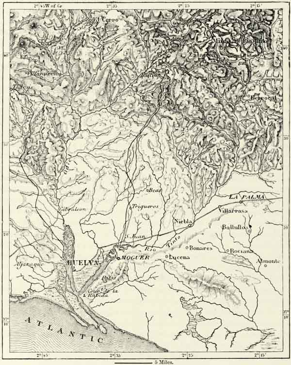
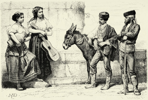
PEASANTS OF CORDOVA, ANDALUSIA.
Their advantageous geographical position accounts for their prosperity, past and present. Córdova and Seville command the fertile plain of the Guadalquivir, and the roads crossing the gaps of the neighbouring mountains converge upon them; Granada has its plentiful supply of water and rich fields; Huelva, Cádiz, {407} Málaga, and Almería are considerable seaports; and Gibraltar occupies a commanding position between two seas. There are other towns less populous, but of great strategical importance, as they command the roads joining the valleys of the Genil and Guadalquivir to the sea.
Amongst the smaller towns which have played a part in history are several to the east of Granada, such as Velez Rubio and Velez Blanco, on the Mediterranean slope; Cullar de Baza, with its subterranean houses excavated in the gypsum, on the western slope of the Vertientes, or “the water-shed;” Huescar, the heir of an old Carthaginian city; and Baza, environed by a fertile plain known as Hoya, or “the hollow.”
Granada, though it celebrates the anniversary of the entrance of Ferdinand and Isabella, is a very inferior place to what it was as the capital of a Moorish kingdom, when it had 60,000 houses and 400,000 inhabitants, and was the busiest and wealthiest town of the peninsula. It is still the sixth city of Spain, but thousands of its ragged inhabitants live in hideous dens, and close to the picturesque suburb of Albaicin a mob largely composed of gipsies has settled down in nauseous caverns. Remains of Moorish buildings are met with only in the suburb named, but at some distance from the city there still exist edifices which bear witness to the glorious reign of its ancient masters. The Torres Vermejas, or “red towers,” occupy a hill to the south; the Generalife, with its delightful gardens, crowns another hill farther east; and between them rise the bastions and towers of the Alhambra, or “red palace,” even in its present dilapidated condition one of the masterpieces of architecture, which has served as a pattern to generations of artists. From the towers of this magnificent building we enjoy a prospect which indelibly impresses itself upon the memory. Granada, with its towers, parks, and villas, lies beneath. The course of the two rivers, Genil and Darro, can be traced amidst the foliage, whilst naked hills bound the verdant plain of La Vega, which has been likened to an “emerald enchased in a sapphire.” The contrast between these savage mountains and the fertile plain, between the beautiful city and precipitous rocks, struck the Moors with admiration, for they saw reflected in them their own nature—an outward impassiveness and a hidden fire. Granada, to them, was the “Queen of Cities,” the “Damascus of the West.” Nor are the modern Spaniards behind them in their admiration of Granada and its vicinity.
There are other beautiful towns in the basin of the Genil, but none can compare with Granada, not even Loja, a “flower in the midst of thorns,” an oasis surrounded by rugged rocks and savage defiles. Jaen, however, almost rivals Granada. It, too, was the seat of a powerful Moorish king, the hills surrounding it are still crowned with the ruins of fortifications buried beneath luxuriant foliage, and the aspect of the town remains oriental to this day.
The upper valley of the Guadalquivir abounds in cities. Baeza had more than 150,000 inhabitants in the time of the Moors, but wars depopulated it, many of the people removing to Granada. Close by is Ubeda, another Moorish town. Higher up in the hills is the mining town of Linares, hardly large enough to {408} shelter 8,000 residents, but actually inhabited by 40,000. In descending the river we pass Andújar, famous on account of its alcarrazas, and about twenty miles below the town of Montoro we reach the marble bridge of Alcolea, celebrated for the many battles which have been fought for its possession.
Fig. 155.—THE ALHAMBRA.
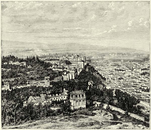
Córdova dates back to the dawn of civilisation. It has been famous and powerful at all times, and the Spanish noblemen are proud of tracing their origin back to this fountain-head of the “blue blood” (sangre azul) which is supposed to flow in the veins of Spanish nobles. It was under the Moors that Córdova reached the apogee of its grandeur; from the ninth century to the close of the twelfth it had nearly a million of inhabitants; and its twenty-four suburbs spread far and wide over the plain and along the lateral valleys. The wealth of its mosques, palaces, and private houses was prodigious; but, more glorious still, Córdova could boast of being the “nursery of science,” for it was the greatest university of the world, abounding in schools and libraries. Civil wars, foreign invasions, and religious fanaticism led to the dispersion of its libraries, and Córdova can no longer boast of being the first city of Andalusia. Most of the old monuments have perished, but there still exists the marvellous mezquita, or mosque, built at the close of the eighth century by Abderrahman and his son. The {409} interior was fitted up in the most lavish manner, the floors being paved with silver, and the walls covered with gold, precious stones, ivory, and ebony, but a considerable portion of the building has been pulled down to make room for a Spanish cathedral.
The more fertile districts of the province of Córdova are at some distance from the Guadalquivir, in the hills to the south. Montilla, one of the towns there, is noted for its wines, as are Aguilar, Baena, Cabra, and Lucena, the latter boasting likewise of some manufactures. Between Córdova and Seville, a distance of over ninety miles, following the sinuosities of the river, we do not meet with a single town of note, for even Palma del Rio, at the mouth of the Genil, is only a small place, though of some importance as the outlet of Ecija, a large town higher up the Genil.
Seville, the reigning queen of Andalusia, boasts of a few remarkable buildings, including the alcazar, a gorgeous cathedral, and the palace known as “Pilate’s House,” in which the Renaissance is admirably wedded with the Moorish style. But more famous than either of these is Giralda’s Tower, with the saint’s revolving statue on the top, like a weathercock. But neither these buildings nor Murillo’s fine paintings have won Seville its epithet of “Enchantress.” For this it is indebted to its gaiety and to a succession of fêtes, amongst which bull-fights figure prominently. Seville became Spanish about the middle of the thirteenth century. Its citizens valiantly defended their municipal liberties against the King of Castile, but they were defeated, and most of its inhabitants then fled to Barbary. The town was repeopled by Christian emigrants. Triana, however, a suburb with which an iron bridge connects it, is inhabited by gipsies, whose secret tribunal has its seat there. A short distance to the north of Triana are the ruins of the amphitheatre of Italica, the old rival of Seville, and the native town of Silius Italicus, and of the Emperors Trajan, Hadrian, and Theodosius. Coria, another Roman city, which had its own mint during the Middle Ages, lies below Seville.
Seville has numerous potteries, but its silks and stuffs interwoven with gold and silver have ceased to command the markets of the world. The largest manufactory of the place, that of tobacco and cigars, is carried on by Government, and employs several thousand workmen.
Alcalá de Guadaira, to the south-east of Seville, supplies the latter with bread, and its delicious springs feed the aqueduct known as Arcos de Carmona, thus called because it runs parallel with the old Roman road leading to Carmona (Carmo).
The towns to the south of Seville are no longer of importance. Utrera, the most considerable amongst them, is a great railway centre, where the line to the marble quarries of Moron, and that passing through the fertile districts of Marchena and Osuna, branch off from the Andalusian main line. The town is well known to aficionados, or sportsmen, on account of the wild bulls which pasture in the neighbouring marismas. Lebrija, with its fine tower imitated from that of Giralda, is still nearer to these marshes, which extend almost to the mouth of the Guadalquivir. {410}
Sanlúcar de Barrameda, at the mouth of the Guadalquivir, with its white and pink houses shaded by palms, is not now the great port it was in the time of the Arabs. It may justly boast of having sent forth, in 1519, the first vessel which circumnavigated the globe, but it is now rather a pleasure resort than a place of commerce. Jerez de la Frontera, in the basin of the Guadalete, is the busiest town between Seville and Cádiz. It is a neat and showy place, surrounded by immense bodegas, or wine vaults, in which are stored the wines grown in the fertile valley of Guadalete, and known as sherry. Near Arcos de la Frontera, in the upper part of the valley, is pointed out the site upon which was fought the famous battle which delivered Spain to the Mussulmans.
The Bay of Cádiz, so well sheltered against winds and waves by the tongue of land which begins at the island of Leon, is surrounded by numerous towns, forming, as it were, but a single city. Rota, on the northern coast of the bay, is encircled by walls of cyclopean aspect. It is the resort of fishermen, and its vintners, though reputed Bœotians, produce one of the best wines of Spain. Farther south, at the mouth of the Guadalete, is the Puerto de Santa María, with its wine stores, at all times a bustling place. Puerto Real, the Portus Gaditanus, lies in a labyrinth of brackish channels, and is now merely a landing-place. The neighbouring dockyard, known as Trocadero, and the arsenal of Carraca, are frequently inhabited only by galley-slaves and their gaolers. The salt-pans near that place are most productive.
San Fernando is the most important town on the island of Leon, to the south of Cádiz. The initial meridian of Spanish mariners is drawn through its observatory. Looking across the navigable channel of San Pedro, which separates the island from the main, we perceive the villas of Chiclana, famous as the training-place of the toreros, or bull-fighters, of Andalusia. Turning to the north, we reach the narrow ridge of the Arrecife, which may be likened to a stalk with Cádiz as its expanded flower. Boatmen point out the supposed ruins of a temple of Hercules, now covered by the sea; and thus much is certain, that the land is at present subsiding, though this subsidence must have been preceded by an upheaval, as the peninsula upon which Cádiz has been built rests upon a foundation of shells, oysters, and molluscs.
Μ
Fig. 156.—CADIZ AND ITS ROADSTEAD.
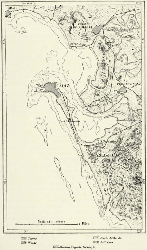
We pass several forts, cross the ramparts of the Cortadura, erected in 1811, and at length find ourselves in the famous city of Cádiz, the heir of the Gadir of the Phœnicians, called Gadira by the Greeks, and Gades by the Romans. Cádiz was the leading city of Iberia when that country first became known. Like other cities, it has known periods of decay, but its great geographical advantages have always enabled it to recover quickly. It is the natural outlet of an extensive and fertile region, and its position near the extremity of the continent enables it successfully to compete with Lisbon for the trade of the New World. Palos may boast of having sent forth the caravelas which discovered the West Indies, but it was Cádiz which reaped all the advantages of this discovery, more especially since the Tribunal of the Indies was transferred to it from Seville (1720). In 1792 Cádiz exported merchandise valued at £2,500,000 sterling to America, {412} and received precious metals and other articles of a value of £7,000,000 in return. Soon afterwards Spain paid for a commercial monopoly maintained during three centuries by the sudden loss of her colonies, and Cádiz found itself dependent upon its fisheries and salt-pans. But recently fortune has again smiled upon the city, and its harbours are crowded with merchantmen.145 Cádiz, with the towns surrounding its bay, has a population of 200,000 souls. The site of the city proper is limited by nature, and its houses have been built to a height of five and six stories. The inhabitants are fond of pleasure, vivacious, and quick at repartee. They have at all times shown themselves to be good patriots, and it was on the island of Leon that the Cortes met to protest against the occupation of the country by the French.
Almería, on the Mediterranean coast of Andalusia, rivalled Cádiz in importance as long as it remained in the possession of the Moors, but prosperity fled the place immediately the Spaniards occupied it. Subsequently the town suffered greatly from the pirates of Barbary, as is proved by the fortress-like cathedral built in the sixteenth century. The aspect of the place, with its narrow streets and old kasba, is quite oriental.
The towns to the west of Almería have a tropical climate and tropical productions. Dailas, said to be the first permanent settlement of the Arabs, is famous for its raisins; to it succeed Adra, at the mouth of the Rio Grande of Alpujarra, Motril, Vélez Málaga, and Málaga, embosomed in gardens watered by the Guadalmedina.