THE MEDITERRANEAN.
Reading edition

I.—HYDROLOGY.
REECE and its insular satellites prove sufficiently that the unstable floods of the Mediterranean have exercised a greater influence upon the march of history than did the solid land upon which man trod. Western civilisation would never have seen the light had not the waters of the Mediterranean washed the shores of Egypt, Phœnicia, Asia Minor, Hellas, Italy, Spain, and Carthage. The western nations would have remained in their primitive barbarism if it had not been for the Mediterranean, which joined Europe, Asia, and Africa; facilitated the intercourse between Aryans, Semites, and Berbers; and rendered more equable the climate of the surrounding countries, thus facilitating access to them. For ages it appeared almost as if mankind could prosper only in the neighbourhood of this central sea, for beyond its basin only decayed nations were to be met with, or tribes not yet awakened to mental activity. “Like frogs around a swamp, so have we settled down on the shores of this sea,” said Plato; and the sea he refers to is the Mediterranean. It is therefore deserving of description quite as much as the inhabited countries which surround it. Unfortunately many mysteries still remain hidden beneath its waves.5

Μ
Fig. 5.—THE DEPTH OF THE MEDITERRANEAN.
From a Chart by M. Delesse.
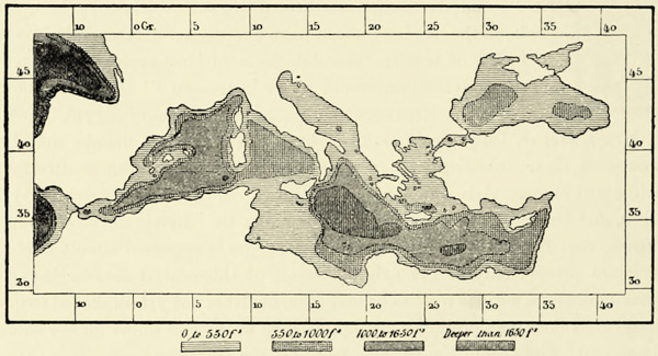
From an examination of the coasts, as well as from the traditions of the people inhabiting them, we learn that the Mediterranean has varied frequently in its contours and extent. The straits which connect its waters with those of the ocean have frequently changed their position. At a time when peninsulas like Greece, and even islands like Malta, formed part of continental masses—and that they did so in a comparatively recent geological epoch is proved by their fossil fauna—the waters of the Mediterranean covered large portions of Africa, of Southern Russia, and even of Asia. The researches of Spratt, Fuchs, and others have satisfactorily proved that towards the close of the miocene age a vast {24} fresh-water lake stretched from the banks of the Aral, across Russia, the plains of the Danube and the Archipelago, as far as Syracuse in Sicily. Then came the briny waters of the ocean. There was a time when the Black Sea and the Caspian connected the Archipelago with the Gulf of the Obi. At another epoch the gulfs of the Syrtes penetrated far inland, and a large portion of what is now the Libyan and Saharan desert was then covered with water. The Strait of Gibraltar, which was torn asunder by Hercules according to the traditions of the ancients, is in reality but of recent origin, and has taken the place of a more ancient strait which joined the Mediterranean to the Red Sea and Indian Ocean: this strait has been restored by human hands, and is known now as the Suez Canal. The coast-lines of the Mediterranean are undergoing perpetual change, owing to the upheaval or subsidence of the countries surrounding it. The Nile, the Po, the Rhone, and other rivers incessantly enlarge the alluvial plains at their mouths, and still further encroach upon the sea. Actually the Mediterranean, with its subordinate seas from the Strait of Gibraltar to the Sea of Azof, covers an area about thirty times that of the British Islands. This area is small if we compare it with the immense development of the coasts and the wealth in peninsulas, which impart an aspect of life and independence to at least one-third of the ancient world. The Mediterranean, though it takes precedence of all the oceans, in consequence of the part it has played in history, nevertheless only covers an area one-seventieth that of the Pacific.6 It is broken up, moreover, into several separate seas, some of them so small in extent that the navigator hardly ever loses sight of the land. In the {25} east we have the Black Sea, with its two dependencies, the Seas of Azof and of Marmara. The Ægean Sea, or Archipelago, with its numerous islands, extends between the deeply indented coasts of Greece, Asia Minor, and Crete. The Adriatic stretches towards the north-west, between the Balkan peninsula and Italy; and the Mediterranean proper is divided into two separate basins, which might appropriately be called the Phœnician and Carthaginian Seas, or the Greek and Roman Mediterraneans. Each of these basins is again subdivided, the one by Crete, the other by the two islands of Sardinia and Corsica. These various subdivisions of the Mediterranean differ in area, and still more in depth. The Sea of Azof almost deserves the name of “Swamp,” which was bestowed upon it by the ancients, for if a ship sinks in it the masts remain visible above the water. The Black Sea has a maximum depth of over 1,000 fathoms, but the narrow strait which joins it to the Sea of Marmara is shallower than many a European river. The cavity filled by the Sea of Marmara is far inferior to that of many an inland lake; and the Dardanelles, like the Bosphorus, are hardly wider than a river. In the Archipelago and the eastern basin of the Mediterranean proper the depth corresponds with the protuberance of the land. Abyssal depths and “pits” of 260 and even of 540 fathoms are to be found in close proximity to the scarped mountain islands of the Cyclades, whilst on the low coasts of Egypt the water deepens only gradually, until in the centre of the Levantine Sea it attains a depth of 1,750 fathoms. The maximum depth—2,170 fathoms—is attained between Crete and Malta. If the whole of the waters of the Mediterranean were to be collected into an aqueous sphere, the latter would have a diameter of 90 miles; if it fell down upon the earth, it would not even wholly cover a country like Switzerland.
The Ionian Sea is separated from the Adriatic by a submarine ridge rising in the Strait of Otranto, and bounded on the west by a shoal or submarine isthmus, already referred to by Strabo, which joins Sicily to Tunis. This isthmus forms the true geological boundary between the western and eastern basins of the Mediterranean, which are connected here by a narrow breach only, the depth of which hardly exceeds 100 fathoms. The western of these basins is the smaller and shallower of the two, but nevertheless it attains a depth of 1,100 fathoms in the Tyrrhenian, and of 1,360 fathoms and even 1,640 in the Balearic Sea, and is separated from the waters of the Atlantic by a submarine ridge lying outside the Strait of Gibraltar, and joining Europe to Africa.7
This subdivision of the Mediterranean into separate basins, divided from each other by shoals or submarine ridges, by islands and promontories, sufficiently explains the contrasts between the phenomena of the open ocean and those observed here. In the Mediterranean, it is well known, the tides are almost everywhere irregular and uncertain. To the east of the Narrows of Gibraltar, in the sea extending between Andalusia and Morocco, the tides are hardly felt at all, and {26} they are, moreover, interfered with to such an extent by currents that it is exceedingly difficult to determine their amplitude, or the establishment of the various ports. Nevertheless the rise and fall of the tidal wave are sufficiently marked to have attracted the attention of Greek and Italian navigators. On the coasts of Catalonia, France, Liguria, Naples, Asia Minor, Syria, and Egypt the oscillation is hardly perceptible, but on those of Eastern Sicily and of the Adriatic the tide sometimes rises three feet, and, if accompanied by storms, may even attain a height of ten feet in certain localities. The Straits of Messina and of Euripo (Eubœa) have their regular tides, and in the Gulf of Gabes the waters rise and fall with the same regularity as in the open ocean. In the Black Sea, however, no tidal movements whatever have been discovered hitherto. It is nevertheless probable that more careful observations will lead to the discovery of a feeble tide, for it is believed that this phenomenon exists even on Lake Michigan, which has only one-fifth the area of the Black Sea.
Μ
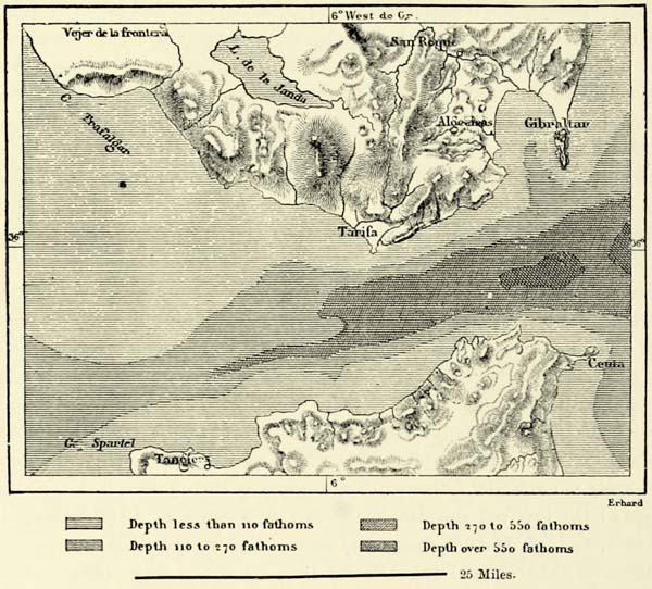
Fig. 6.—THE STRAIT OF GIBRALTAR.
According to Robiquet, Randegger, and others. Scale 1 : 750,000.
The Mediterranean differs not only from the open ocean with respect to the feebleness and irregularity of its tides, but it is likewise without a great stream-current keeping in constant circulation the whole body of its waters. The currents which have been observed in various divisions of the Mediterranean can be ascribed only to local causes. An Italian geographer of the last century, Montanari, has {27} advanced an hypothesis of a great circuit current which entered the Mediterranean through the Strait of Gibraltar, and, after having washed the shores of Africa as far as Egypt, returned to the west along those of Asia and Europe; but careful observers have vainly endeavoured to discover its existence. They have met only with local currents, produced by an indraught of the waters of the Atlantic, by winds, by the floods of rivers, or by an excess of evaporation. One of these currents sets along the coasts of Morocco and Algeria from west to east; another flows along the Italian coast of the Adriatic from north to south; and a third from the mouth of the Rhone in the direction of Cette and Port Vendres. In fact, the configuration of the sea-bottom, and particularly the shoal between Sicily and Tunis, precludes the existence of any but surface currents in the Mediterranean.
Amongst the local currents the existence of which has been most clearly established are those which convey the waters of the Sea of Azof into the Black Sea, and those of the latter into the Archipelago. The Don more than makes up for the loss by evaporation in the Sea of Azof, and its surplus waters find an exit through the Strait of Kerch into the Black Sea. Similarly the waters of the Dniester, the Dnieper, the Rion, and of the rivers of Asia Minor, and, above all, of the Danube, which by itself conveys a larger volume of water into the Black Sea than all the others combined, are discharged through the Bosphorus and the Dardanelles into the Archipelago. On the other hand, the Archipelago returns to the Black Sea, by means of a submarine counter-current and of lateral surface currents, a certain quantity of salt water for the fresh water which it receives in excess. This exchange accounts for the salineness of the waters of the Black Sea. The volume of fresh water discharged into it by the Danube and other rivers is so large that in the course of a thousand years its waters would become perfectly fresh, if there did not exist these compensatory highly saline counter-currents.
Analogous phenomena take place at the other extremity of the Mediterranean. Evaporation there is excessive, owing to the neighbourhood of the burning sands of the deserts, the winds from which blow freely over the sea, absorbing the vapours and dispersing the clouds. The loss by evaporation amounts to at least seven feet in the course of a year, and as the annual rainfall is estimated to amount to twenty inches only, and the volume of water discharged annually by all the tributary rivers of the Mediterranean, if uniformly spread over its surface, would hardly exceed ten inches in depth, there exists thus an excess of evaporation amounting annually to more than four feet; and this excess has to be made good by an inflow of the waters of the Atlantic, which takes place through the Strait of Gibraltar, whose volume far exceeds that of the Amazon in a state of flood. This inflow of the waters of the Atlantic is felt, as a current, as far as the coasts of Sicily, and, like all other currents, it is bounded by lateral currents flowing in a direction contrary to that of the main current. During ebb the insetting Atlantic current takes up the whole of the strait, but when the tide rises the Mediterranean resists more successfully the pressure of the ocean, and this struggle gives birth to {28} two counter-currents, one of which skirts the coast of Europe, the other that of Africa between Ceuta and Cape Spartel; the latter is the larger and more powerful of the two. In addition to these, there exists a submarine current, which conveys the highly saline and heavier waters of the Mediterranean out into the Atlantic.
The quantity of salt held in solution in various parts of the Mediterranean differs widely, as the submarine ridges and shoals which divide it into separate basins do not permit its waters to mingle as freely as in the open ocean. Owing to the excess of evaporation, the quantity of salt is greater on the whole than in the Atlantic, and this is the case more particularly on the coast of Africa. But in the Black Sea it is far less, and near the mouths of some of the large rivers which enter that sea the water is almost fresh.8
The temperature of the Mediterranean is affected by the same causes which produce its varying salineness, viz. the existence of shoals and banks, which separate it into distinct sub-basins. In the open ocean the currents convey to all latitudes large bodies of water, some of them heated by a tropical sun, others cooled by contact with the ice of the polar regions. But these layers of unequal density are regularly superimposed one upon the other, owing to the differences in their temperature: the warm water remains on the surface, whilst the cold water descends to the bottom. In the Mediterranean an analogous superimposition exists only to a depth of 110 fathoms, which is the depth of the Atlantic current, flowing into it through the Strait of Gibraltar. If a thermometer be lowered to a greater depth it will indicate no further decrease of temperature, and the immense body of water, remaining almost still at the bottom of the Mediterranean, has an equable temperature of about 56° F. Observations made at depths varying between 110 and 1,640 fathoms have always exhibited the same result. Professor Carpenter believes, however, that the abyssal waters of some of the volcanic regions have a somewhat higher temperature, which may be due to the presence of lava in a state of fusion.
II.—ANIMAL LIFE. FISHERIES AND SALT PANS.
Another remarkable feature of the abyssal waters of the Mediterranean consists in their poverty of animal life. No doubt there is some life; the dredgings of the Porcupine and the telegraph cables, which, on being brought to the surface, were found to be covered with shells and polypes, prove this. But, compared with those of the ocean, the depths of the Mediterranean are veritable deserts. Edward Forbes, who explored the waters of the Archipelago, arrived at the conclusion that their abyssal depths were entirely devoid of life, but he was wrong when he assumed an exceptional case like this to represent a universal law. Carpenter thinks that this absence of life in the depths of the Mediterranean is due to the great quantity of organic remains which is carried into it by the rivers. These remains absorb the oxygen of the water, and part with their carbonic acid, which is detrimental to {29} animal life. In numerous instances the water of the Mediterranean contains only one-fourth the normal quantity of the former gas, but fifty per cent. in excess of the latter. To the presence of these organic remains the Mediterranean is probably indebted for its beautiful azure colour, so different from the black waters of most oceans. This blue, then, which is justly celebrated by poets, would thus be caused by the impurity of the water. M. Delesse has shown that the bottom of nearly the whole of the Mediterranean is covered with ooze.
The regions of the Mediterranean immediately below the surface abound in animal life, particularly on the coasts of Sicily and Southern Italy; but nearly all species, whether fish, testacea, or others, are of Atlantic origin. The Mediterranean, in spite of its vast extent, as far as its fauna is concerned, is nothing but a gulf of the Lusitanian Ocean. Its longitudinal extension and the similarity of climate in its various portions have favoured the migration of animals through the Strait of Gibraltar as far as the coasts of Syria. At the same time, animal life is most varied near this point of entry, and the species met with in the western basin are generally of greater size than those which exist in the eastern. A very small proportion of non-Atlantic species recalls the fact that the Mediterranean formerly communicated with the Red Sea and the Indian Ocean. But amongst a total of more than eight hundred molluscs there are only about thirty which have reached the seas of Greece and Sicily through the ancient straits separating Africa from Asia, instead of through the Strait of Gibraltar.9 The diminution in the number of species in an easterly direction becomes most striking when we reach the narrow channel of the Dardanelles and the Bosphorus. The Black Sea, in fact, differs essentially from the Mediterranean proper as regards temperature. It is refrigerated by north-easterly winds sweeping over its surface, to the extent even of portions of it becoming now and then covered with a thin coating of ice, adhering to the coast. The Sea of Azof has frequently disappeared beneath a thick crust of ice, and even the whole of the Black Sea has been frozen over in winters of exceptional severity. The cold surface waters, together with those conveyed into the Black Sea by large rivers, descend to the bottom, and prove most detrimental to animal life. Echinodermata and zoophytes are not met with at all in the Black Sea; certain classes of molluscs, already rare in the Levantine Sea and the Archipelago, are likewise absent; and the total number of species of molluscs is only one-tenth of what it is in the Mediterranean. Fish are numerous as far as individuals go, but their species are few. In fact, the fauna of the Black Sea appears to resemble that of the Caspian, from which it is cut off, rather than that of the Greek seas, with which the Sea of Marmara connects it.
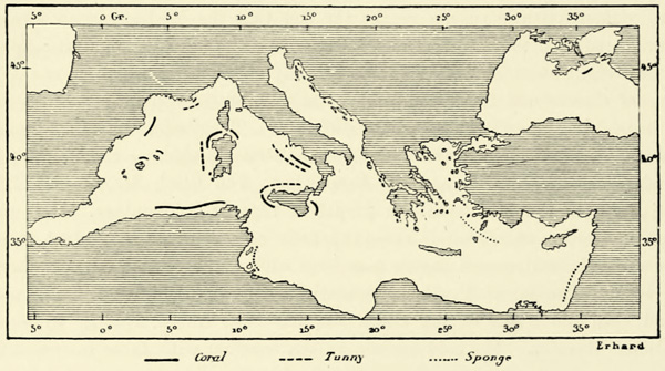
In addition to the species which have found a second home in the Mediterranean, there are some that must still be looked upon as visitors. Such are the sharks, which extend their incursions to the seas of Sicily, to the Adriatic, and even to the coasts of Egypt and Syria. Such, also, are the larger cetacea—whales, rorquals, and sperm whales—whose visits, however, are confined now to the Tyrrhenian {30} basin, and become less frequent from century to century. The tunny-fish of the Mediterranean are also visitors from the coasts of Lusitania. First-rate swimmers, they enter through the Strait of Gibraltar in spring, ascend the whole of the Mediterranean, make the tour of the Black Sea, and return in autumn to the Atlantic, after having accomplished a journey of some 5,600 miles. In the opinion of the fishermen the tunnies go upon their travels in three immense divisions or shoals, and it is the central shoal which visits the coasts of the Tyrrhenian Sea, and consists of the largest and strongest fish. Each of the three divisions appears to be composed of individuals about the same age. For mutual protection they swim in troops, for they are preyed upon by enemies innumerable. Dolphins and other fish of prey follow their track, but their great destroyer is man. In the summer the tunny fishery, or tonnaro, is carried on in numerous bays of Sicily, Sardinia, Naples, and of Provence. Enormous structures consisting of nets enclose these bays, and they are ingeniously arranged so as to close gradually around the captured fish, which, passing from net to net, find themselves at last in the “chamber of death,” where they are massacred. Millions of pounds of flesh are annually obtained from these floating “slaughter-houses,” yet the tunny appears year after year in multitudes, and on the same coasts. There may have been a slight decrease in the number, but their closely packed masses still invade the “Golden Horn” of Byzance and other bays, as they did when first they attracted the attention of Greek naturalists.
Μ
Fig. 7.—THE PRINCIPAL FISHERIES OF THE MEDITERRANEAN.
Scale 1 : 38,300,000.
Next to the tunny fisheries those of the sardines and anchovies are most important. Sea-urchins and other products of the sea are eaten by the inhabitants of the coasts, particularly in Italy, but there is no part of the Mediterranean where animal life is so abundant and so prodigious in quantity as on the celebrated banks of Newfoundland, or on the coasts of Portugal or of the Canaries.
A large number of fishing-boats are engaged, not in the capture of fish, but in {31} the collection of articles of dress or of the toilet. The purple-shell fisheries on the coasts of Phœnicia, the Peloponnesus, and Greece are no longer carried on, but hundreds of boats are employed annually during the fine season in fishing for coral or sponges.
Coral is found most abundantly in the western portion of the Mediterranean, and the Italian fishermen do not confine themselves to their own shores—to Sicily, Naples, and Sardinia—but also visit the Strait of Bonifacio, the sea off St. Tropez, the vicinity of Cape Creus in Spain, and the waters of Barbary. Ordinary sponges are collected in the Gulf of Gabes, and at the other extremity of the Mediterranean, on the coasts of Syria and Asia Minor, and in the straits winding between the Cyclades and Sporades. Sponges are usually found at a depth of from 12 to 150 feet, and can be gathered by divers; whilst coral occurs at far greater depths, and has to be wrenched off with an iron instrument, which brings up its fragments, mixed with ooze, seaweeds, and the remains of marine animalculæ. This industry is still in a state of barbarism: those devoted to it are not as yet sufficiently acquainted with the sea and its inhabitants to enable them to carry on the sponge and coral fisheries in a rational manner. Yet this they must aim at: they must learn how to deprive Proteus, the ever-changing deity, of his dominion over the inhabitants of the deep.
Next to the fisheries, the preparation of sea salt constitutes one of the leading industries of the Mediterranean coast-lands. But this industry, too, is frequently carried on in a primitive way, and only in the course of the present century have scientific methods been introduced in connection with it. The Mediterranean is admirably suited for the production of salt, for its waters have a high temperature, they hold a very large quantity of salt in solution, the rise and fall of the tides are inconsiderable, and flat seashores alternate with steep coasts and promontories. The most productive salt marshes of the Mediterranean are probably those on the Lagoon, or Étang de Thau, near Cette, and on the littoral of Hyères; but considerable ones may also be met with on the coasts of Spain, in Italy, in Sardinia, Sicily, Istria, and even on the “limans” of Bessarabia, bordering upon the Black Sea. The annual production of salt is estimated at more than a million tons, and exceeds, therefore, the entire tonnage of the commercial marine of France.10 But this quantity, large as it is, is infinitesimal if we compare it with the saline contents of the sea, and science will enable us one day to raise a far more abundant treasure from its sterile depths.11
III.—COMMERCE AND NAVIGATION.
Whatever advantages may be yielded by fisheries and salt-works, they shrink into insignificance if we compare them with the great gain—material, intellectual, {32} and moral—which mankind has derived from the navigation of this inland sea. It has repeatedly been pointed out by historians that the disposition of the coasts, islands, and peninsulas of the Mediterranean of the Phœnicians and Greeks admirably favoured the first essays in maritime commerce. Many causes have contributed to make this sea the cradle of European commerce: the faint summits of distant lands visible even before the port has been quitted; numerous nooks along the coasts where a safe refuge may be found in case of storms; regular land and sea breezes; an equability of climate which makes the sailor feel at home wherever business takes him; and, moreover, a great variety of productions resulting from the diverse configuration of the Mediterranean coast-lands. And this commerce, does it not lead to a peaceful intercourse between peoples on neutral ground, and to mutual enlightenment, brought about by an interchange of ideas? Every coast-line which facilitates the intercourse between nations is, therefore, of immense value as a means of developing civilisation.
Civilisation for many centuries marched from the south-east towards the north-west, and Phœnicia, Greece, Italy, and France have successively become great centres of human intelligence. This historical phenomenon is due to the configuration of the sea, which has been the vehicle of migratory nations. In fact, the axis of civilisation, if this expression be allowed, has become confounded with that axis of the Mediterranean which extends from the coast of Syria to the Gulf of Lions, on the coast of France. But the Mediterranean has ceased to be the only centre of gravitation of Europe, which sends its merchantmen now to the two Americas and the farthest East; and civilisation no longer marches in that general line from east to west, but rather radiates in all directions. Civilising streams depart from England and Germany towards Northern America, and from the Latinised countries of Europe towards Southern America. Their direction is still westerly, but they have been deflected towards the south, to meet the conditions imposed by climate and the geographical configuration of land and sea.
It is interesting to trace the changes which have occurred in the historical importance of the Mediterranean. As long as that sea remained the great highway between nations, the commercial republics were content to extend this highway towards the east, by establishing caravan routes to the Gulf of Persia, to India, and to China. In the Middle Ages Genoese factories dotted the coasts of the Black Sea, and extended thence through Trans-Caucasia as far as the Caspian. European travellers, and particularly Italians, at that time crossed Western Asia in all directions; and many a route hardly known in our days was then frequented almost daily. But for several centuries direct commercial intercourse with Central Asia has dwindled down to small proportions.
The Mediterranean had ceased to be a great ocean highway. Our navigators, no longer dreading a boundless sea, took their ships into every part of the ocean. The difficult and perilous land routes were abandoned, the once busy markets of Central Asia became solitudes, and the Mediterranean itself a veritable blind alley, as far as the world’s commerce was concerned. This condition of affairs lasted for many years, but since the middle of this century our relations with the East have {33} been renewed, and the lost ground is rapidly being recovered. Within the last year a great commercial revolution has been effected through the opening of one of the ancient gates of the Mediterranean, and the Suez Canal has become the great highway of steamers between Western Europe, the Indies, and Australia. Possibly, at no distant future, a similar canal will enable our merchantmen to proceed from the Black Sea to the Caspian, and perhaps even to the Amu and the Syr, in the very heart of the ancient continent.
It is thus that the great centres of intercommunication, or vital points of our planet, as we should like to call them, become shifted in the course of time. Port Said, an improvised town on a desert shore, has thus become a centre of attraction for travellers and merchandise, whilst the neighbouring cities of Tyre and Sidon have dwindled down into miserable villages, with nothing to indicate the proud position they held in the past. Carthage, too, has perished, and Venice decayed. Many a thriving place on the shores of the Mediterranean has been reduced to insignificance through the silting up of its harbour, the employment of larger vessels, the loss of independence, or through political changes of all kinds. But in nearly every instance some neighbouring town has taken the place of these decayed harbours, and most of the great routes of commerce have maintained their original directions, and their terminal points, as well as intermediate stations, have remained in the same localities.
There are, moreover, certain places which ships are almost obliged to frequent, and where towns of importance arise as a matter of course. Such are the Straits of Gibraltar and of Messina; such, also, are places like Genoa, Trieste, and Saloniki, which occupy the bottom of gulfs or bays penetrating far into the land. Ports offering the greatest facilities for embarking merchandise intended for foreign countries, such as Marseilles and Alexandria, are likewise natural centres of attraction to merchants. One town there is in the Mediterranean which enjoys at one and the same time every one of the geographical advantages which we have pointed out, for it is situated on a strait connecting two seas and separating two continents. This town is Constantinople, and despite the deplorable maladministration under which it suffers, its position alone has enabled it to maintain its place amongst the great cities of the world.
The ports of the Mediterranean no longer enjoy a monopoly of commerce as they did for thousands of years, but the number of ships to be met with in that inland sea is, nevertheless, proportionately far greater than what we meet with on the open oceans. The commercial marine of the Mediterranean numbers thirty-seven thousand vessels, of a capacity of two million seven hundred and ninety-six thousand tons, without counting fishing-boats. This is more than one-fourth of the entire commercial marine of the world, as respects the number of ships, and one-sixth of it as regards tonnage. This inferiority of tonnage is due to the small vessels of ancient types which still maintain their ground in Greece and Italy, and which possess certain advantages for the coasting trade.
To this marine of the Mediterranean should be added the vessels belonging to foreign ports, which visit it for purposes of trade, and amongst which those of {34} England take the most prominent rank. The Government of Great Britain has even taken care to secure itself a place amongst the Mediterranean powers. It has occupied Gibraltar, at the eastern entrance to this basin, and taken possession of Malta, which commands its centre; and although the western entrance, formed by the Suez Canal, is not in its possession, its garrisons on Perim and the rock of Aden are able at any moment to close up the only approach to it which leads from the Indian Ocean through the Red Sea.
Μ
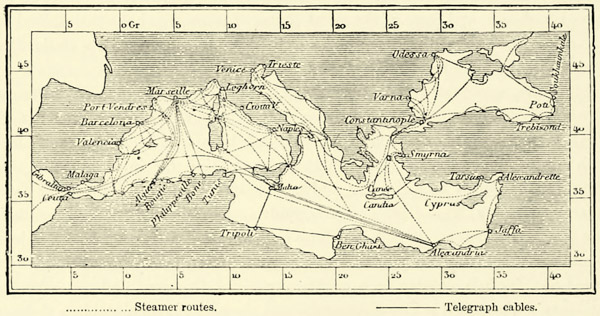
Fig. 8.—STEAMER ROUTES AND TELEGRAPHS IN THE MEDITERRANEAN.
Scale 1 : 45,000,000.
The share which England takes in the commerce of the Mediterranean is considerable, but it is surpassed by far by that of France and Italy. A sovereign who aspired to the dominion of the world once spoke of the inland sea extending from the Strait of Gibraltar to Egypt as a “French lake;” but with equal justice might it be called a Greek, a Dalmatian, or Spanish lake, and with still greater an Italian lake. The pirates of Barbary were, in reality, the last “masters” of the Mediterranean: their swift vessels presented themselves unexpectedly before the coast towns, and carried off their inhabitants. But since their predatory fleets have been destroyed, the Mediterranean has become the common property of the world, and the meshes of an international network of maritime highways become closer from year to year. The merchantmen no longer pursue their voyages in company as they did in former times, discharging their cargo from port to port, for a single vessel may venture now into any portion of the Mediterranean in safety. Still there remain the dangers of reefs and of storms. The art of navigation has made vast progress; most of the capes, at least on the coasts of Europe, are lit up by lighthouses; the approaches to the ports are rendered easy by lightships, buoys, and beacons; but shipwrecks are nevertheless of frequent occurrence. Even large vessels founder sometimes, without leaving a stray plank behind to indicate the place of their disappearance.
Steamers travelling along prescribed routes are now gradually taking the place of sailing vessels, and where they cross at frequent intervals they may be {35} likened to ferry-boats crossing a river. The regularity and speed of these steam ferries; the facilities which they afford for the conveyance of merchandise; the increasing number of railways which convey the produce of the interior to the seaports; and lastly, the submarine telegraphs, which have established instantaneous means of communication between the principal ports, all contribute towards the growth of Mediterranean commerce. This commerce, including imports and exports, and the transit through the Suez Canal, actually amounts to about £353,000,000, a year.12 This may not be much for a maritime population of a hundred millions, but a perceptible increase is taking place from year to year. We should also bear in mind that, face to face with the busy peninsulas of Europe, there lies torrid Africa, an inert mass, avoided by the sailors of our own age as much as it was by those of ancient Greece. Its coasts are hardly ever visited, with the exception of those portions which extend from Oran to Tunis, and from Alexandria to Port Said. It is matter of surprise, too, that certain localities which formerly attracted crowds of vessels, such as Cyrenaica, Cyprus, and beautiful Crete, at the very entrance to the Archipelago, should still remain outside the ordinary track of our steamers.