ITALY.* (continued 4)
Reading edition
The commercial towns on the Adriatic slope of the Apennines are of greater importance than those to the east. Foggia, on the Tavoglieri di Puglia, upon which converge four railways and several high-roads, is a great mart for provisions, and in importance and wealth, though not in population, is the second city of Naples. Several smaller towns surround it like satellites, such as San Severo, Cerignola, and Lucera, which became wealthy in the thirteenth century, when the Saracens, exiled from Sicily by Frederick II., settled here. Foggia, however, and its sister cities, in spite of the proximity of the Bay of Manfredonia, have no direct outlet to the sea, for the coast for a distance of thirty miles, from Manfredonia to the mouth of the Otranto, is fringed by insalubrious lagoons and marshes. The reclamation of these is absolutely necessary to enable Southern Italy to develop its great natural resources. The largest of these lagoons or marshes, that of Salpi, has been reduced to the extent of one-half by the alluvium conveyed into it by the rivers Carapella and Ofanto, but as long as the new land remains uncultivated deadly miasmata will not cease. At the eastern extremity of this marsh stood the ancient city of Salapia.
At the extremity of the peninsula of Gargano, to the north of these marshes, are the harbours of Manfredonia and Vieste, very favourably situated for sailing vessels compelled by stress of weather to put into port. The first harbour to the south of the marshes is Barletta, near which is the “Field of Blood,” recalling the battle of Cannæ. Barletta exports cereals, wines, oil, and fruit, partly grown on the old feudal estates near the inland towns of Andria, Corata, and Ruyo. The latter, the ancient Rubi, has yielded a rich harvest of antiquities of every kind. The other coast towns to the south-east of Barletta are—Trani, which carried on a considerable Levant trade towards the close of the Middle Ages; Bisceglia; Molfetta; Bari, the most populous town on the Adriatic slope of Naples; and Monopoli, all of which are much frequented by coasting vessels. Tasano, near Monopoli, occupies the site of the ancient port of Gnatia, and, like Rubi, has well repaid the search for archæological remains.
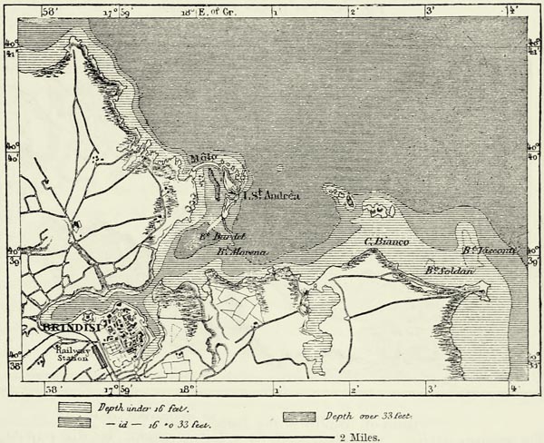
Brindisi, at the northern extremity of the peninsula of Otranto, in the time of the Romans and during the Crusades, was one of the great stations on the route from Western Europe to the East, and is likely again to occupy that position. It lies at the very entrance to the Adriatic. Its roadstead is excellent, and its harbour one of the best on the Mediterranean. The entrance is narrow, and was formerly choked up with the remains of wrecks and mud, but is now practicable for steamers of the largest size. The two arms of the harbour bear some resemblance to the antlers of a stag, and to this circumstance the town is indebted for its name, which is of Messapian origin, and means “antler-shaped.” Brindisi has recently become the European terminus of the overland route to India, and many new buildings have risen in honour of this event, which it {307} was expected would convert the town into an emporium of Eastern trade. These expectations have not been realised. Several thousand hurried travellers pass that way every year, but Marseilles, Genoa, and Trieste have lost none of their importance as commercial ports in consequence. Moreover, when the Turkish railways are completed, the position now held by Brindisi will most likely be transferred to Saloniki or Constantinople.105
Μ
Fig. 111.—THE HARBOUR OF BRINDISI IN 1871.
Scale 1 : 86,000.
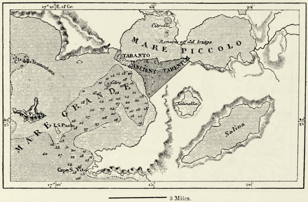
Taranto, on the gulf of the same name, is making an effort, like its neighbour Brindisi, to revive its ancient commercial activity. Its harbour, the Piccolo Mare, or “little sea,” is deep and perfectly sheltered, and its roadstead, or Mare Grande, is fairly protected by two outlying islands against the surge. As at Spezia, springs of fresh water, known as Citro and Citrello, rise from the bottom of the harbour as well as in the roadstead. The geographical position of Taranto enables it successfully to compete with Bari and the other ports of the Adriatic for the commerce of inland towns like Matera, Gravina, and Altamura, and it appears to be destined to become the great emporium for the Ionian trade. No other town of Italy offers equal facilities for the construction of a port, but the two channels, one natural and the other artificial, which join the two “seas” have become choked, and only small craft are now able to reach the harbour. Modern Taranto is a small town, with narrow streets, built to the east of the Greek city of Tarentum, on the {308} limestone rock bounded by the two channels. Its commerce has been slowly increasing since the opening of the railway, its industry being limited to fishing, oyster-dredging, and the manufacture of bay-salt; and the Tarantese enjoy the reputation of being the most indolent people in Italy. The heaps of shells on the beach no longer supply the purple for which the town was formerly famous; but the inhabitants still make use of the byssus of a bivalve in the manufacture of very strong gloves.
The only towns of any importance in the peninsula stretching southwards from Brindisi and Taranto are Lecco and Gallipoli, the former surrounded by cotton plantations, the latter—the Kallipolis, or “beautiful city,” of the Greeks—picturesquely perched on an islet attached by a bridge to the mainland. The surrounding country, owing to the want of moisture, is comparatively barren.
Μ
Fig. 112.—THE HARBOUR OF TARANTO.
Scale 1 : 208,000.
The western peninsula of Naples is far better irrigated than that of Otranto, but this advantage is counterbalanced to a large extent by the mountainous nature of the country, and by its frequent earthquakes. Potenza, a town at the very neck of this peninsula, half-way between the Gulf of Taranto and the Bay of Salerno, most happily situated as a place of commerce, has repeatedly been destroyed by earthquakes, and its inhabitants have only ventured to rebuild it in a temporary manner.
The famous old cities of Calabria, such as Metapontum and Heraclea, have ceased to exist. Sybaris the powerful, with walls six miles in circumference, and suburbs extending for eight miles along the Crati, is now covered with alluvium and shrubs—“its very ruins have perished.” The city of the Locri, to the south of Gerace, which existed until the tenth century, when it was destroyed by the Saracens, has at least retained ruins of its walls, temples, and other buildings. {309} The only one of these old cities still in existence is Cotrone, the ancient Crotona, the “gateway to the granary of Calabria.” In travelling along the coasts of Greater Greece we feel astonished at the few ruins of a past which exercised so powerful an influence upon the history of mankind.
The existing towns of Calabria cannot compare in importance with those of a past age. Rossano, near the site of Sybaris, is the small capital of a district, and is visited only by coasters. Cosenza, in the beautiful valley of the Crati, at the foot of the wooded Sila, keeps up its communications with Naples and Messina through the harbour of Paola. Catanzaro exports its oil, silk, and fruit either by way of the Bay of Squillace, on the shores of which Hannibal once pitched his camp, or through Pizzo, a small port at the southern extremity of the Bay of Santa Eufemia. Reggio, nestling in groves of lemon and orange trees at the foot of the Aspromonte, is the most important town of Calabria. It stands on the narrow strait separating the mainland from the island of Sicily, and could not fail to absorb some of the commerce passing through that central gateway of the Mediterranean. Messina and Reggio mutually complement each other, and the prosperity of the one must result in that of the sister city.106
VII.—SICILY.
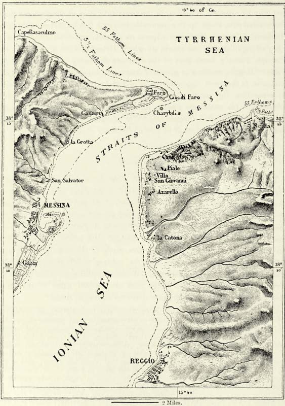
The Trinacria of the ancients, the island with the “three promontories,” is clearly a dependency of the Italian peninsula, from which it is separated by a narrow arm of the sea. The Strait of Messina, where narrowest, is not quite two miles in width. It can be easily crossed in barges, and, with the resources at our command, a bridge might easily be thrown across it, similar enterprises having succeeded elsewhere. It can hardly be doubted that before the close of this century either a tunnel or a bridge will join Sicily to the mainland, and human industry will thus restore in some way the isthmus which formerly joined the Cape of Faro to the Italian Aspromonte. We know nothing about the period when this rupture took place, but to judge from the ancient name of the strait—Heptastadion—it must have been much narrower in former times.107 {310}
Μ
Fig. 113.—THE STRAIT OF MESSINA.
Scale 1 : 156,000.
From an historical point of view Sicily may still be looked upon as a portion of the mainland, for the strait can be crossed almost as easily as a wide river. On the other hand, it enjoys all the advantages of a maritime position. Situate in the very centre of the Mediterranean, between the Tyrrhenian and the eastern basin, it commands all the commercial high-roads which lead from the Atlantic to the East. Its excellent harbours invite navigators to stay on its coasts; its soil is {311} exceedingly fertile; the most varied natural resources insure the existence of its inhabitants; and a genial climate promotes the development of life. Hardly a district of Europe appears to be in a more favourable position for supporting a dense population in comfort. Sicily, indeed, is more densely populated and wealthier than the neighbouring island of Sardinia or either of the Neapolitan provinces, the Campania alone excepted, and rivals in importance the provinces of Northern Italy.108
Sicily, whenever it has been allowed to rejoice in the possession of peace and freedom, has always recovered with wonderful rapidity; and it would certainly now be one of the most prosperous countries if wars had not so frequently devastated it, and the yoke of foreign oppressors had not weighed so heavily upon it.
The triangular island of Sicily would possess great regularity of structure if it were not for the bold mass of Mount Etna, which rises above the shores of the Ionian Sea at the entrance of the Strait of Messina. From its base to the summit of its crater, that huge protuberance forms a region apart, differing from the rest of Sicily not only geologically, but also with respect to its products, cultivation, and inhabitants.
Μ
Fig. 114.—PROFILE OF MOUNT ETNA.

Ancient mariners mostly looked upon the Sicilian volcano as the highest mountain in the world; nor did they err much as respects the world known to them, for only at the two extremities of the Mediterranean, in Spain and Syria, do we meet with mountains exceeding this one in height; and Mount Etna is not only remarkable from its isolated position, but likewise by the beauty of its contours, the lurid sheen of its incandescent lavas, and the column of smoke rising from its summit. From whatever side we approach Sicily, its snowy head is seen rising high above all the surrounding mountains. Its position in the very centre of the Mediterranean contributed in no small measure to secure to it a pre-eminence amongst mountains. It was looked upon as the “pillar of the heavens,” and at a later epoch the Arabs only spoke of it as el Jebel, “the mountain,” which has been corrupted by the people dwelling near it into “Mongibello.”
The mean slopes of Mount Etna, prolonged as they are by streams of lava extending in every direction, are very gentle, and on looking at a profile of this mountain it will hardly be believed that its aspect is so majestic. It occupies, in fact, an area of no less than 460 square miles, and its base has a development of about 80 miles. The whole of this space is bounded by the sea, and by the valleys of the Alcantara and Simeto. A saddle, only 2,820 feet in height, connects it in the north-west with the mountain system of the remainder of Italy. Small cones of eruption are met with beyond the mass of the volcano to the north {312} of the Alcantara, and streams of lava having filled up the ancient valley of the Simeto, that river was forced to excavate itself another bed through rocks of basalt, and now descends to the sea in rapids and cascades.
An enormous hollow, covering an area of ten square miles, and more than 3,000 feet in depth, occupies a portion of the western slope of the volcano. This is the Val di Bove, a vast amphitheatre of explosion, the bottom of which is dotted over with subsidiary craters, and which rises in gigantic steps, over which, when the mountain is in a state of eruption, pour fiery cascades of lava. Lyell has shown that this Val di Bove is the ancient crater of Mount Etna, but that, at some period not known to us, the existing terminal vent opened a couple of miles farther west. The steep sides of the Val di Bove enable us to gain a considerable insight into the history of the volcano, for the various layers of lava may be studied there at leisure. The cliffs upon which stands the town of Aci Reale afford a similar opportunity for embracing at one glance a long period of its history. These cliffs, over 300 feet in height, consist of seven distinct layers of lava, successively poured forth from the bowels of Mount Etna. Each layer consists nearly throughout of a compact mass, affording no hold for the roots of plants, but their surfaces have invariably been converted into tufa, or even mould, owing to atmospheric agencies which operated for centuries after each eruption. It has likewise been proved not only that these cliffs increased in height in consequence of successive eruptions, but that they were also repeatedly upheaved from below. Lines of erosion resulting from the action of the waves can be distinctly traced at various elevations above the present level of the Mediterranean. The lavas, too, have undergone a change of structure since they were poured forth, as is proved by beautiful caverns enclosed by prismatic columns of basalt, and by the islet of the Cyclops, near Aci Trezza.
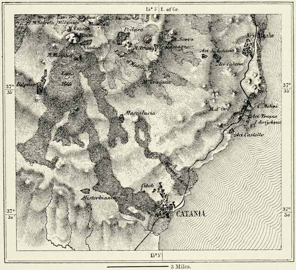
During the last two thousand years Mount Etna has had more than a hundred eruptions, some of them continuing for a number of years. Hitherto it has not been possible to trace any regularity in these eruptions. They appear to occur at irregular intervals, and the quantity of lava poured forth from the principal or any subsidiary cone varies exceedingly. The most considerable stream of lava of which we have any record was that which overwhelmed the city of Catania in 1669. It first converted the fields of Nicolosi into a fiery lake, then enveloped a portion of the hill of Monpilieri, which for a time arrested its progress, and finally divided into three separate streams, the principal of which descended upon Catania. It swept away a part of that town, filled up its port, and formed a promontory in its stead. The quantity of lava poured forth on that occasion has been estimated at 3,532 millions of cubic feet; and nearly 40 square miles of fertile land, supporting a population of 20,000 souls, were converted into a stony waste. The double cone of Monti Rossi, with its beautiful crater now grown over with golden-flowered broom, was formed by the ashes ejected during that great eruption. More than 700 subsidiary cones, similar to the Monti Rossi, are scattered over the exterior slopes of Mount Etna, and bear witness to as many eruptions. The most ancient amongst them have been nearly obliterated in the {313} course of ages, or buried beneath streams of lava, but the others still retain their conical shape, and rise to a height of many hundred feet. Several amongst them are now covered with forests, and the craters of others have been converted into gardens—delightful cup-shaped hollows, where villas shine like gems set in verdure.
Μ
Fig. 115.—THE LAVA STREAM OF CATANIA.
Scale 1 : 200,000.
Most of these subsidiary cones lie at an elevation of between 3,300 and 6,500 feet above the sea, and it is there the internal forces make themselves most strongly felt. As a rule the subterranean activity is less violent near the summit, and during most of the eruptions the great terminal crater merely serves as a vent, through which the aqueous vapours and gases make their escape. Fumaroles surrounding it convert the soil into a kind of pap, and the substances which escape from them streak the scoriæ with brilliant colours—scarlet, yellow, and emerald green. The internal heat makes itself felt on many parts of the exterior slopes. It converts loose rocks into a compact mass, far less difficult to climb than are the loose cinders of Mount Vesuvius. Travellers ascending the mountain need fear nothing from volcanic bombs. Showers of stone are occasionally ejected from the principal vent, but this is quite an exceptional occurrence. If it were not so, the small structure above the precipices of the Val di Bove, which dates from the {314} time of the Romans, and is known as the “Philosopher’s Tower,” would long ago have been buried beneath débris. A meteorological observatory might therefore be established with safety on the summit of this mountain, and no better station could be found for giving warning of approaching storms.
Μ
Fig. 116.—SUBSIDIARY CONES OF MOUNT ETNA.
The summit of Mount Etna, 10,866 feet in height, does not penetrate the zone of perennial snow, and the heat emitted from the subterranean focus soon melts the incipient glaciers which accumulate in hollows. Nevertheless the upper half of the mountain is covered with a shroud of white during a great part of the year. It might be imagined that the snow and copious rains would give birth to numerous rivulets descending from the slopes of the volcano; but the small stones and cinders which cover the solid beds of lava promptly absorb all moisture, and springs are met with only in a few favoured spots. They are abundant on the lower slopes, or in the immediate vicinity of the sea. One of these is the fountain of Acis, which issues from the chaos of rocks which Polyphemus is said to have hurled at the ships of sage Ulysses. Another gives birth to the river Amenano, which rises in the town of Catania, and hastens in silvery cascades towards its port. When we look at these clear springs in the midst of black sands and burnt rocks we are able to comprehend the fancy of the ancient Greeks, who regarded them as divine beings, in whose honour they struck medals and raised statues.
Though running streams are scarcely met with on the slopes of Mount Etna, its cinders retain a sufficient quantity of moisture to support a luxuriant vegetation. The mountain is clad with verdure except where the surface of the lava is too compact to be penetrated by the roots of plants. Only the highest regions, which are covered with snow during the greater part of the year, are barren. It is {315} a remarkable fact that the flora of the Alps should not be met with on Mount Etna, although the temperature suits it exactly.
Formerly the volcano was surrounded by a belt of forests occupying the zone between the cultivated lands and the region of snow and cinders. Such is the case no longer. On the southern slope, which is that usually ascended by tourists, there are no forests at all, and only the trunk of some ancient oak is occasionally met with. On the other slopes groves of trees are more frequent, particularly in the north, where there remain a few lofty trees, which impart quite an alpine character to the scenery. But the wood-cutters prosecute their work of extermination without mercy, and it is to be feared that the time is not very distant when even the last vestiges of the ancient forests will have disappeared. The magnificent chestnuts on the western slopes, amongst which could be admired until recently the “tree of the hundred horses,” bear witness to the astonishing fertility of the lava. If the cultivators of the soil only desired it, a few years would suffice to restore to Mount Etna its ancient covering of foliage.
The cultivated zone occupying the lower slopes of the mountains presents in many places the appearance of a beautiful garden. There are groves of olive, orange, lemon, and other fruit trees, in the midst of which rise clumps of palms, and villas, churches, and monasteries peep out from this mass of verdure. The fertility of the soil is so great that it supports a population three or four times more numerous than that in any other part of Italy. More than 300,000 inhabitants dwell on the slopes of a mountain which might be supposed to inspire terror, and which actually bursts at intervals, burying fertile fields beneath a fiery deluge. Town succeeds town along its base like pearls in a necklace, and when a stream of lava effects a breach in this chain of human habitations it is closed up again as soon as the lava has had time to cool. From the rim of the crater the mountain climber looks down with astonishment upon these human ant-hills. The concentric zones of houses and verdure contrast curiously with the snows and ashes occupying the centre of the picture, and with the barren limestone rocks beyond the Simeto. And this is only a small portion of the vast and marvellous prospect, embracing a radius of 124 miles. Well may the beholder be enchanted by the unrivalled spectacle of three seas, of a deeper blue than the skies, washing the shores of Sicily, of Calabria, and of the Æolian Islands.
Mount Pelorus, which forms a continuation of the chain of the Aspromonte of Calabria, is of very inferior height to Mount Etna, but it had existed for ages when the space now occupied by the volcano was only a bay of the sea. It was formerly believed that a crater existed on the highest summit of Pelorus dedicated to Neptune, and now to the “Mother of God,” or Dinna Mare (3,600 feet), but such is not the case. These mountains consist of primitive and transition rocks, with beds of limestone and marble on their flanks. They first follow the coast of the Ionian Sea, where they form numerous steep promontories, and then, turning abruptly towards the west, run parallel with that of the Æolian Sea. Their culminating point, near the centre, is known as Madonia (6,336 feet), and the magnificent forests which still clothe it impart to that part of the island {316} quite a northern aspect, and we might almost fancy ourselves in the Apennines or Maritime Alps. Limestone promontories of the most varied profile advance into the blue waters of the sea, and render this coast one of the most beautiful of the Mediterranean. We are seized with admiration when we behold the enormous quadrangular block of Cefalù, the more undulating hill of Termini, the vertical masses of Coltafano, and above all, near Palermo, the natural fortress of Monte Pellegrino (1,970 feet), an almost inaccessible rock, upon which Hamilcar Barca resisted for three years the efforts of a Roman army to dislodge him. Monte San Giuliano (2,300 feet), an almost isolated limestone summit, terminates this chain in the west. It is the Eryx of the ancients, who dedicated it to Venus.
The mountains which branch off from this main chain towards the south gradually decrease in height as they approach the sea. The principal slopes of the island descend towards the Ionian and Sicilian Seas, and all its perennial rivers—the Platani, Salso, and Simeto—flow in these directions. The rivers on the northern slope are mere fiumare, formidable after heavy rains, but lost in beds of shingle during the dry season. The lakes and swamps of the island are likewise confined to the southern slope of the mountains. Amongst them are the pantani, and the Lake, or biviere, of Lentini, which is the most extensive sheet of water in Sicily; the Lake of Pergusa, or Enna, formerly surrounded by flowery meadows in which Proserpine was seized by Pluto; the biviere of Terranova; and several marshy tracts, the remains of ancient bays of the sea. This southern coast of the island contrasts most unfavourably with the northern, for, in the place of picturesque promontories of the most varied outline, we meet with a monotonous sandy shore, devoid of all shade. Natural harbours are scarce there, and during the winter storms vessels frequenting it are exposed to much danger.
The southern slope of Sicily, to the south of the Madonia, consists of tertiary and more recent rocks, abounding in fossil shells mostly belonging to species still living in the neighbouring sea. In the hills to the south of Catania these tertiary rocks alternate with strata of volcanic origin, which are evidently derived from submarine eruptions. This process is still going on between Girgenti and the island of Pantellaria, where the submarine volcano of Giulia or Ferdinandea occasionally rises above the surface of the sea. It was seen in 1801, and thirty years later it had another eruption, resulting in the formation of an island four miles in circumference, which was examined by Jussieu and Constant Prévost. In 1863 it appeared for the third time. But the waves of the sea have always washed away the ashes and cinders ejected on these occasions, spreading them in regular layers over the bottom of the sea, and thus producing an alternation of strata similar to that observed at Catania. In 1840 the summit of this submarine volcano was covered with only six feet of water, but recently no soundings were obtained at a depth of fifty fathoms.
Μ
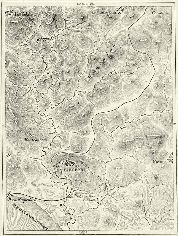
Fig. 117.—THE MACCALUBAS AND GIRGENTI.
Scale 1 : 100,000.
This submarine volcano is not the only witness to the activity of subterranean forces in Southern Italy. We meet there with mineral springs discharging carbonic acid and other gases, which prove fatal to the smaller animals venturing within their influence, and with a naphtha lake near Palagonia, from which escape, {317} likewise, irrespirable gases. A similar phenomenon may be witnessed in connection with the Lake of Pergusa, which occupies an ancient crater about four miles in circumference, and usually abounds in tench and eels. From time to time, however, an escape of poisonous gases appears to take place from the bottom of the lake, which kills the fish, whose carcasses rise to the surface. Another of these salses has made its appearance farther west, near the Palazzo Adriano, {318} and, indeed, the whole of underground Sicily appears to be in a state of chemical effervescence.
Next to Mount Etna the great centre of volcanic activity in Sicily appears to be near Girgenti, at a place known as the Maccalubas. The aspect of this spot changes with the seasons. In summer bubbles of gas escape from small craters filled with liquid mud, which occasionally overflows, and runs down the exterior slopes. The rains of winter almost obliterate these miniature volcanoes, and the plain is then converted into one mass of mud, from which the gases escape. At the beginning of this century the soil was occasionally shaken by earthquakes, and on these occasions jets of mud and stones were ejected to a height of ten or twenty yards. The Maccalubas appear now to be in a state of quiescence, for these mud volcanoes also seem to have their regular periods of rest and activity.
The deposits of sulphur, which constitute one of the riches of Sicily, undoubtedly owe their existence to these subterranean lakes of seething lava. These sulphur beds are met with in the tertiary strata extending from Centorbi to Cattolica, in the province of Girgenti. They date from the epoch of the Upper Miocene, and are deposited upon layers of fossil infusoria exhaling a bituminous odour. Geologists are not yet agreed on the origin of these sulphur beds, but it is most likely that they are derived from sulphate of lime carried to the surface by hot springs. In the same formation beds of gypsum and of rock-salt are met with, and the latter may frequently be traced from a saline effervescence known as occhi di sale (“eyes of salt”).
Sicily, like Greece, enjoys one of the happiest climates. The heat of summer is tempered by sea breezes which blow regularly during the hottest part of each day. The cold of winter would not be felt at all if it were not for the total absence of every comfort in the houses, for ice is not known, and snow exceedingly rare. The autumn rains are abundant, but there are many fine days even during that season. The prevailing winds from the north and west are salubrious, but the sirocco, which usually blows towards the south-east, is deadly, especially when it reaches the northern coast. It generally blows for three or four days, and during that time no one thinks of clarifying wine, salting meat, or painting houses or furniture. This wind is the great drawback to the climate. In some parts of Sicily the exhalations from the swamps are dangerous, but this is entirely the fault of man. It is owing to his neglect that Agosta and Syracuse suffer from fevers, and that death forbids the stranger to approach the ruins of ancient Himera.109
Temperature and moisture impart to the vegetation of the plains and lower valleys a semi-tropical aspect. Many plants of Asia and Africa have become acclimatized in Sicily. Groups of date-palms are seen in the gardens, and the plains around Sciacca, almost African in their appearance, abound in groves of dwarf palms, or giummare, to which ancient Selinus was indebted for its epithet of Palmosa. Cotton grows on the slopes of the hills up to a height of 600 feet above the sea; bananas, sugar-cane, and bamboos do not require the shelter of {319} greenhouses; the Victoria regia covers the ponds with its huge leaves and flowers; the papyrus of the Nile, which is not known anywhere else in Europe, chokes up the bed of the Anapo, near Syracuse: formerly it grew also in the Oreto, near Palermo, but it does so no longer. The cactus of Barbary (Cactus opuntia) has become the most characteristic plant of the coast districts of Sicily, and is rapidly covering the most unpromising beds of lava. These and other plants flourish most luxuriantly on the southern slopes of Mount Etna, where the orange-tree bears fruit at a height of 1,700 feet, and the larch ascends even to 7,400 feet. These slopes facing the African sun are the hottest spots in Europe, for the volcano shelters them from the winds of the north, whilst its dark-coloured scoriæ and cinders absorb the rays of the mid-day sun.
Those portions of Sicily which are clothed with trees or shrubs are always green, for orange-trees, olive-trees, carob-trees, laurels, mastic-trees, tamarisks, cypresses, and pines retain their verdure even in winter, when nature wears a desolate aspect in our own latitudes. There is no “season,” so to say, for with a little care all kinds of vegetables can be had throughout the year. The gardens around Syracuse are famous above all others, because of the striking manner in which they contrast with the naked rocks surrounding them. The most delightful amongst them is the Intagliatella, or Latomia de’ Greci, which occupies an old quarry where Greek slaves dressed the stones used in erecting the palaces of Syracuse. The vegetation there is most luxuriant; the trunks of the trees rise above masses of shrubs, their branches are covered with creeping plants, flowers and ripening fruit cover the paths, and birds without number sing in the foliage. This earthly paradise is surrounded by precipitous walls of rock covered with ivy, or bare and white as on the day when Athenian slaves were at work there.
Sicily lies on the high-road of all the nations who ever disputed the command of the Mediterranean, and its population consequently consists of a mixture of the most heterogeneous elements. Irrespectively of Sicani, Siculi, and other aboriginal nations, whose position amongst the European family is uncertain, but who probably spoke a language akin to that of the Latins, we know that Phœnicians and Carthaginians successively settled on its shores, and that the Greeks were almost as numerous there as in their native country. Twenty-five centuries have passed since the Greeks founded their first colony, Naxos, at the foot of Mount Etna. Soon afterwards Syracuse, Leontini, Catania, Megara Hyblæa, Messina, and other colonies sprang into existence, until the whole of the littoral region was in the hands of the Greeks, the native populations being pushed back into the interior. In Sicily the Greek met with the same climate, and with rocks and mountains similar in aspect to those of his native home. The “Marmorean” port and the wide bay of Syracuse, the acropolis and Mount Hybla, do they not recall Attica or the Peloponnesus? The fountain of Arethusa, on the island of Ortygia, which is supplied through underground channels, reminds us of the fountain of Erasinos and of many others in Hellas, which find their way through fissures in the limestone rocks to the seashore. The Syracusans said that the river Alpheus, enamoured of {320} the nymph Arethusa, did not mingle its waters with those of the Ionian, but found its way through subterranean channels to the coast of Sicily, where it rose again at the side of the fountain dedicated to the object of his adoration, bringing the flowers and fruits of beloved Greece. This legend bears testimony to the great love which the Greek bore his native land, whose very fountains and plants were supposed to follow him into his new home.
If we may judge from the number of inhabitants with which the principal towns were credited at that time, Sicily must have had a population of several millions of Greeks. The Carthaginian merchants and soldiers, on the other hand, though they were the masters of portions of the island for two or three centuries, never settled upon it, and only a few walls, coins, and inscriptions bear witness now of their ever having been present. It has been very judiciously remarked by M. Dennis that the most striking evidence of their reign is presented in the desolate sites of the cities of Himera and Selinus. At the same time we must not forget that the Carthaginians, by intermingling with the existing population, materially affected the ulterior destinies of the island. The Romans, who held Sicily for nearly seven centuries, did so in a still higher degree. Vandals and Goths likewise left traces behind them. The Saracens, themselves a mixed race, imparted their Southern impetuosity to the Sicilians, whilst their conquerors, the Normans, endowed them with the daring and indomitable courage which at that period animated these sons of the North. In 1071, when the Normans laid siege to Palermo, no less than five languages were spoken on the island, viz. Arabic, Hebrew, Greek, Latin, and vulgar Sicilian. But Arabic was the tongue of the civilised inhabitants, and even during the dominion of the Normans inscriptions upon palaces and churches were written in it. It was at the court of King Roger that Edrisi wrote his “Geography,” one of the great monuments of science. In 1223 the last Arabs were made to emigrate to Naples, but by that time much Arab blood already flowed through the veins of the inhabitants.
Later on, the character of the population was still further modified by French, Germans, Spaniards, and Aragonese, and all this helped to make them a people differing in appearance, manners, habits, and feelings from their Italian neighbours. These islanders look upon every inhabitant of the mainland as a foreigner. The absence of roads on the island enabled the different groups of its population to maintain their distinct idioms and character during a very long period. The Lombards whom the Romans transplanted to Benevento and Palermo spoke their native dialect long after it had become extinct in Lombardy. Even now there are about 50,000 Sicilians who speak this ancient Lombard tongue. At San Fratello, on a steep hill on the northern coast, this idiom is spoken with the greatest purity. Nor has the Italian wholly supplanted the vulgar Sicilian in the interior of the island. We meet with many Greek and Arab words. One of the most curious words is that of val, which is applied to various districts of Sicily, and is supposed to have been derived from vali, the Arab term for “governor.” The Sicilian idiom is less sonorous than the Italian. Vowels standing between consonants are frequently suppressed, and the o, and even the a and i (ee), are {321} changed into oo, which renders the speech hard and indistinct. The language lends itself, however, admirably to poetry, and the Sicilian popular songs are quite equal in natural grace and delicacy to the much-admired rispetti of Tuscany.
Of all the emigrants who have settled on the island the Albanians alone have not become merged in the general population. Locally known as Greci, they still form separate communities, speaking their own language and observing special religious rites, in several of the towns of the interior, and more especially at Piana de’ Greci, which occupies a commanding hill to the south of Palermo. Nor is the fusion amongst the other races as complete as it appears to be at the first glance. The population around Mount Etna, who are, perhaps, more purely Greek in blood than the Greeks themselves, are noted for their grace, gaiety, and sweetness of disposition. They are the most intelligent portion of the population of Sicily. Those of Trapani and San Giuliani are said to be the best-looking, and their women delight the stranger by the regularity and beauty of their features. The Palermitans, on the other hand, in whose veins flows much Arab blood, are for the most part unprepossessing in their appearance. They open their house but rarely to strangers, and jealously shut up their women in its most retired part.
The most ferocious usages of war, piracy, and brigandage have kept their ground longer at Palermo and its environs than anywhere else. The laws of the omerta, or “men of heart,” make vengeance a duty. A chi ti toglie il pane, e tu toglili la vita ! (“Take the life of him who has taken your bread !”) is its fundamental principle; but in practice Palermitan vengeance is far from possessing the simplicity of the Corsican vendetta, for it is complicated by the most atrocious cruelties. No less than four or five thousand Palermitans are said to be affiliated to the secret league of the maffia, whose members subsist upon every kind of roguery. Up to 1865 the brigands were masters in the environs of that town. They virtually laid siege to the town, separating it from its more distant suburbs. Strangers were afraid to leave lest they should be murdered or captured by bandits; and no farmer could harvest his corn or olives, or shear his sheep, without paying toll to these highwaymen. More than ten years have passed since then, but in spite of measures of exceptional severity the maffia still exists.
The history of this association, which dates its origin back to the time of the Norman kings, remains yet to be written. It has always flourished most in time of political troubles, and consequent misery. No doubt things have grown worse in the course of the last twenty years; taxes have been increased, the conscription established, and many abrupt changes, such as are inseparable from a new political regimen, have been introduced. The people, accustomed to put up with ancient abuses, have not yet learnt to bear the burdens imposed in connection with the annexation of the island to the kingdom of Italy. Nevertheless the Sicilians grow more Italian from day to day. Community of language and of interests attaches the island to the peninsula, and the time is not far distant when both countries will gravitate in the same orbit. Italy is most highly interested in establishing feelings of friendship with the inhabitants of the island, and in developing its resources. The rapid increase of the population, which is said to have {322} tripled since 1734, bears witness to the great natural riches of the country; and what might not be achieved if the barbarous processes now in force there were superseded by the scientific methods of our own time?
Sicily was the favourite haunt of Ceres, and in the plain of Catania this beneficent goddess taught man the art of cultivating the soil. The Sicilians have not forgotten this teaching, for nearly half the area is covered with corn-fields; but they have not improved their system of cultivation since those fabulous times, and improvements can hardly be effected as long as the restrictions imposed by the feudal tenure introduced by the Normans are allowed to exist. The agricultural implements are of a primitive kind, manure is hardly known, and the fate of the crops depends entirely upon nature. When travelling through the country districts of Sicily, we are struck by not meeting with isolated houses. There are no villages, for all the cultivators of the soil live in towns, and are content to travel daily to their fields, which are occasionally at a distance of six miles. Sometimes they pass the night there, in a cavern or a ditch covered with boughs, and at harvest-time the labourers sleep in improvised sheds. This absence of human habitations imparts an air of solemn sadness to vast corn-fields covering valleys and slopes, and we almost fancy we are wandering through a deserted country, and wonder for whose benefit the crops are ripening.
Corn-fields cover a greater area than that devoted to the cultivation of all other objects put together; nevertheless the latter articles represent a higher pecuniary value. The orchards, vineyards, and gardens near the towns are a far greater source of wealth than the distant corn-fields. In former times wheat was the principal article of export; now Sicily is no longer a granary, but promises to become a vast emporium of fruit. Even now the crop of oranges grown there, which consists of seven kinds, subdivided into four hundred varieties, represents a value of £2,000,000 a year. The marvellous gardens which surround Palermo are steadily increasing at the expense of the ancient plantations of ash, and ascend the hills to a height of 1,150 feet. Hundreds of millions of oranges are exported annually to Continental Europe, England, and America, and the inferior sorts are converted into essential oils, citric acid, or citrate of lime. The last is used in printing stuffs, and Sicily enjoys a monopoly in its manufacture.
Sicily likewise occupies a foremost place as a vine-growing country, and supplies more than a fourth of the wine produced throughout Italy. The cultivation of the vine, which is carried on to a large extent by foreigners, is much better understood there than on the neighbouring peninsula, and the wines exported from Marsala, Syracuse, Alcamo, and Milazzo are justly held in high estimation. Excellent wine is also grown on the southern and western slopes of Mount Etna, to which the heat of the sun imparts much fire. England and non-Italian Europe are the great consumers of the wines of Sicily, as they are of its oils, almonds, cotton, saffron, sumach, and manna, extracted, like that of the Calabrias, from a kind of ash. Raw silk, which Sicily was the first to produce in Europe, is likewise exported in considerable quantities.
Sulphur is the great mineral product of the island. The beds vary much in {323} richness, but even where they contain only five or six per cent. a light brought to the walls of the mine will cause the sulphur to boil like pitch. The blocks extracted from the mine are piled up in the open air, where they remain exposed to the destructive action of the atmosphere. The fragments are then heaped up over the flame of a furnace, which causes the stones to split, the melted sulphur flowing into moulds placed beneath. By this primitive process only two-thirds of the sulphur contained in the rock are extracted, but it proves nevertheless most remunerative. About 200,000 tons of sulphur, or more than two-thirds of the sulphur required for manufacturing purposes throughout Europe, are annually exported from Sicily, and the known deposits of the island have been computed to contain from 40,000,000 to 50,000,000 tons. To the north of Girgenti and in other parts of Sicily sulphureous plaster has been used in the construction of the houses, and the atmosphere there is at all times impregnated with an odour of sulphur.
Rock-salt is met with in the same formations as the sulphur, and in quantities almost inexhaustible, but salt is not a rare article, and even the Sicilians prefer to gather it from the salt swamps extending along the coast, the most productive of which are near Trapani, at the western extremity of the island. At the same spot the sea yields the best coral of Sicily. The tunny fishery is carried on mostly in the great bays between Trapani and Palermo, while most of the swordfish are captured in the Strait of Messina. The seas of Sicily abound in fish, and the islanders boast of being the most expert fishermen of the Western Mediterranean.
Until recently communications in Sicily were kept up almost exclusively by sea. In 1866 the only carriage road of the island, which connects Messina with Palermo, was hardly made use of by travellers, and even now the most important mines of sulphur and salt communicate with the seashore only by mule-paths; and the inhabitants are actually opposed to the construction of roads, from fear of their interfering with the existing modes of transport. The road which connects the harbour of Terranova with Caltanissetta has been under construction for twenty years, although it is the only one which joins the interior of the country to the sea-coast. Railways to some extent supply this deficiency of roads, but are being built very slowly, hardly more than 250 miles being at present open for traffic.
Palermo the “happy,” the capital of Sicily, is one of the great towns of Italy. At the time of the Arabs it surpassed all towns of the peninsula in population, but at present, though increasing rapidly, it yields to Naples, Milan, and Rome. No other town of Europe can boast of an equally delicious climate, nor is any fairer to look upon from a distance. Bold barren mountains enclose a marvellous garden, the famous “shell of gold” (conca d’oro), from the midst of which rise towers and domes, palms with fan-shaped leaves, and pines, commanded in the south by the huge ecclesiastical edifices of Monreale. Termini is the only city of Sicily which rivals Palmero in the beauty of its site, and it truly merits its epithet of splendissime. {324}
Fig. 118.—PALERMO AND MONTE PELLEGRINO.
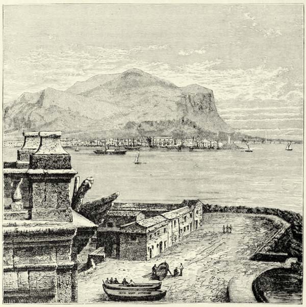
But the beauty of the country contrasts most painfully with the misery and filth reigning in most of the quarters of the capital. Palermo has its sumptuous edifices. It boasts of a cathedral lavishly decorated; its royal palace and palatine chapel, covered with mosaics, and harmoniously combining the beauties of Byzantine, Moorish, and Roman art, are unique of their kind; the church of Monreale, in one of its suburbs, may challenge Ravenna by the number of its mosaics. There are Moorish palaces, a few modern monuments, and two broad streets, which a Spanish governor had made in the shape of a cross. But, besides these, we only meet with dark and narrow streets and wretched tenements, the windows of which are stuffed with rags. Down to a recent period Palermo was undeserving its Greek name of “Port of all Nations.” Enclosed within mountains, and having no communications with the interior, its commerce was merely local, and its exports were limited to the produce of its fisheries and of its gardens. Though {325} far more populous than Genoa, its commerce is only half that of the Ligurian city, but it is rapidly on the increase.
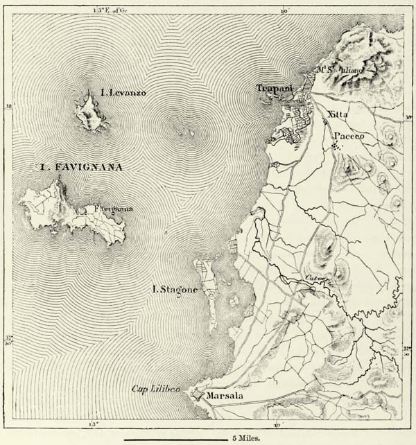
Trapani, a colony of the Carthaginians like Palermo, and Marsala, so famous for its wines, at the western extremity of the island, are proportionately far busier than the capital. Trapani, built on a sickle-shaped promontory, carries on a lively trade. The salt marshes near it are amongst the most productive in all Italy;110 tunny, coral, and sponge fishing is carried on; and the artisans of the town are skilled as weavers, masons, and jewellers. The harbour is one of the best in Italy; the roadstead is well sheltered by the outlying Ægadian Islands; and the ambition of the inhabitants, who look forward to a time when Trapani will be the principal emporium for the trade with Tunis, is likely to be realized on the completion of a railway to Messina. The harbour of Mazzara, the outlet for the produce of the inland towns of Castelvetrano and Salemi, lies closer to Tunis, but its shelter is indifferent. As to Marsala—the “Mars ed Allah,” or God’s haven, of the Arabs—its port was filled up by Charles V., and has only recently been reconstructed. It is, however, not of sufficient depth for large vessels, and only salt and wine are exported from it to France and England. Marsala occupies the site of the ancient city of Lilybæum, which had a population of 900,000 souls when Diodorus Siculus wrote his Geography. It has recently become famous in consequence of the landing there of Garibaldi and his thousand followers in 1860, and its being the spot from which they entered upon the triumphant march which ended in the battle of the Volturno and the capture of Gaeta.
Messina the “noble” is the great commercial centre of Sicily, and the only port of that island where vessels of all nations meet. Messina is a stage on the ocean high-roads which join or connect Western Europe and the Levant. Its roadstead is one of the safest, and vessels in distress are certain to find protection there. Moreover, vessels coming from the Tyrrhenian, and fearful of encountering the dangerous currents of the strait during a storm, may easily find shelter at Milazzo, to the north of it. The port of Messina is formed by a sickle-shaped tongue of land, making a natural breakwater.111 There are few cities in Europe which are more exposed to the destructive action of earthquakes than Messina, and the traces of the great shock of 1783, which swamped the vessels in the harbour, undermined the palaces along the seashore, and caused the death of more than a thousand persons, have not yet entirely disappeared.
Catania, the sub-Etnean, as its Greek name implies, is menaced not only by earthquakes, but also by volcanic eruptions. It, too, enjoys a high amount of commercial prosperity, and exports the surplus produce of the towns situated at the foot of the volcano, among which are Acireale, with its orange groves; Giarre, with its dusty streets; Paterno, abounding in thermal springs; Aderno, on the {326} summit of a rock of lava; Bronte, at the junction of two streams of scoriæ; and Randazza, commanded by an ancient Norman castle. Catania also monopolizes the export of the produce of the inland districts of Eastern Sicily; it is the great railway centre of the island, and several carriage roads converge upon it. Its port has grown too small for the business carried on there, and it is proposed to enlarge it by means of piers and breakwaters.
Μ
Fig. 119.—TRAPANI AND MARSALA.
Scale 1 : 270,000.
It is quite natural that on an island, no locality of which is more than forty miles from the sea, all great towns should be met with on the coast, where there are greater facilities for commerce. Still a few centres of population sprang up in the interior, either in the midst of the most fertile districts or at the crossings of the most-frequented lines of communication. Nicosia, the Lombard city, is thus a natural place of passage between Catania and the northern coast of the island. Corleone occupies a similar position with respect to Palermo and the African slope {327} of the island. Castro Giovanni, the ancient Enna, likewise occupies a privileged position, for it stands on an elevated plateau in the very centre of the island: a large stone near it is said by the inhabitants to be an ancient altar of Ceres. Piazza Armerina l’opulentissime, and Caltagirone, surnamed la gratissima on account of the fertility of its fields, are both populous towns, which carry on a considerable commerce through Terranova, in the building of which the stones of the old temples of Gela have been utilised. Caltanissetta, farther to the west, and its neighbour Canicatti, export their produce through the port of Licata.
In the south-eastern corner of Sicily there are likewise several inland towns of some importance, amongst which Ragusa and Modica are the most considerable. Comiso, an industrious place, lies farther to the west, and is surrounded by cotton plantations. The valley of the Hipparis, sung by Pindar, separates it from Vittoria, the saline plains of which furnish much of the soda exported to Marseilles. Noto, like most towns in that part of Sicily, is at some distance from the coast, but its twin city, Avola, stands upon the shore of the Ionian Sea. Noto and Avola were both overthrown by the earthquake of 1693, and have been rebuilt with geometrical regularity near their former sites. The fields of Avola, though not very fertile by nature, are amongst the best cultivated of the island, and it is there only that the production of the sugar-cane has attained to any importance.
On the northern slope of the hills forming the back-bone of the island there are several other towns inhabited by the agricultural population. Lentini, the ancient Leontini, which boasts of being the oldest city in the island, is at present only a poor place, having been wholly rebuilt since the earthquake of 1693. Militello has been restored since the same epoch, and Grammicheli was founded in the eighteenth century to afford a shelter for the inhabitants of Occhiala, which was destroyed by an earthquake. Vizzini and Licodia di Vizzini are remarkable on account of the beds of lava near them, which alternate with layers of marine fossils, and Mineo stands near a small crater of the swamp of Palici. The popular songs of Mineo are famous throughout Sicily. The marvellous “stone of poetry” is shown near it, and all those who kiss it are said to become poets.
Μ
Fig. 120.—SYRACUSE.
Scale 1 : 100,000.
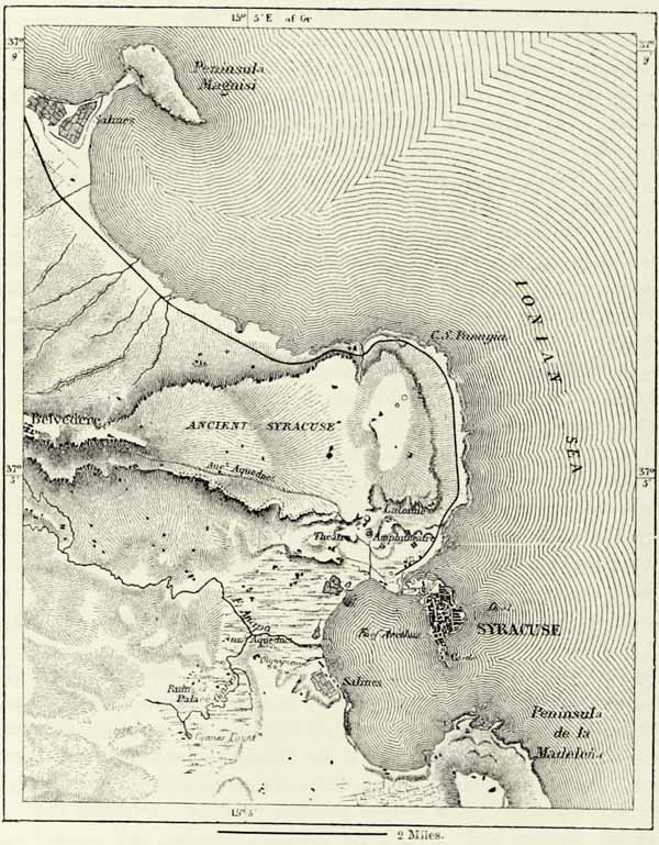
Southern Sicily is poor in natural ports, and formerly, along the whole of that part of the coast which faces Africa, there were only open roadsteads and beaches. On the Ionian coast, however, two excellent harbours are met with, viz. those of Agosta and Syracuse, which are very much like each other in outline and general features. Agosta, or Augusta, the successor of the Greek city of Megara Hyblæa, is now nothing more than a fortress besieged by fever. Syracuse, the ancient city of the Dorians, and at one time the most populous and wealthy city of the Mediterranean, has been reduced to a simple provincial capital. That city, whose inhabitants even during the last century celebrated their great victory over the Athenians, is now hardly more than a heap of ruins. Its “marble port,” formerly surrounded by statues, is now frequented only by small boats, and its great harbour, large enough for contending squadrons, lies deserted. All that remains of it is contained in the small island of Ortygia, {328} separated from the mainland by fortifications, a ditch, and the swamps of Syraca. The vast peninsula of limestone formerly occupied by the city is at present inhabited only by a few farmers, whose houses stand near the canals of irrigation. The grand edifices erected by the inhabitants of ancient Syracuse are now represented by the ruins of columns on the banks of the Anapo rising from the “azure” fountain of Cyane; by the fortifications of the Epipolæ and Euryelum erected by Archimedes, and now known as Belvedere; by the remains of baths, an enormous altar large enough for hecatombs of sacrifices, an amphitheatre, and an admirable theatre for 25,000 spectators, who were able to see at a glance from their {329} seats the whole of the ancient city, with its temples and fleets of merchantmen. Nothing, however, is better calculated to convey an idea of the ancient grandeur of the city than the vast quarries or lautumiæ and the subterranean catacombs, more extensive than those of Naples, and not yet wholly explored. In former times the summit of the island of Ortygia was occupied by an acropolis, in which stood a temple of Minerva, a rival of the Parthenon of Athens. Sailors, on leaving the port, were bound to look towards this temple, holding in their hands a vase of burning charcoal taken from the altar of Juno, which they flung into the sea when they lost sight of it. Portions of the temple still exist, but its beautiful columns have been covered with plaster and incorporated in an ugly church.
Fig. 121.—TEMPLE OF CONCORD AT GIRGENTI.
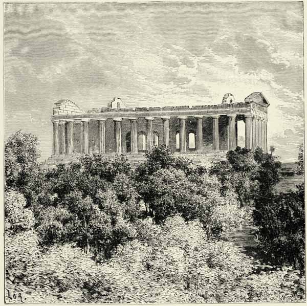
There are other Hellenic ruins in Sicily, which, in the eyes of artists, make that island a worthy rival of Greece itself. Girgenti, the ancient Acragas, or {330} Agrigentum, which numbered its inhabitants by hundreds of thousands, but is now a poor place like Syracuse, possesses ruins of at least ten temples or religious edifices, of which that dedicated to Olympian Jupiter was the largest in all Italy, and has been made use of in the construction of the present mole. Another, that dedicated to Concord, is in a better state of preservation than any other Greek temple outside the limits of Hellas. The modern city occupies merely the site of the ancient acropolis, and is built upon a layer of shelly sandstone, which descends in steps towards the sea. The cathedral has been built from materials taken from a temple of Jupiter Atabyrios, and its baptismal font is an ancient sarcophagus upon which are represented the loves of Phædra and Hippolytus. In former times Agrigentum reached to within a couple of miles from the sea. The modern port, named in honour of one of the most famous sons of the city, lies to the west of the ancient Hellenic Emporium, at a distance of four miles from the city. It is the busiest harbour on the southern coast, and large quantities of sulphur are exported from it (see Fig. 117, p. 317).
Sciacca, another seaside town farther to the west, in one of those localities of the island most exposed to earthquakes, boasts of being the modern representative of Selinus, though that Greek city was situated about fourteen miles farther west, to the south of Castelvetrano. Its seven temples have been overthrown by earthquakes, but they still present us with remains of the purest Doric style. The metopes of three of them have been conveyed to Palermo, where they form the most precious ornaments of the museum.
Segesta, on the north coast, no longer exists, but there still remain the ruins of a magnificent temple. Other remains of Greek art abound in all parts of the island, and there are also monuments erected by the Romans. If we contrast these ancient edifices with those raised since by Byzantines, Moors, Normans, Spaniards, and Neapolitans, we are bound to admit that the latter exhibit no progress, but decadence. Alas ! how very much inferior are the inhabitants of modern Syracuse in comparison with the fellow-citizens of an Archimedes !
Sicily offers most striking examples of towns changing their positions in consequence of political disturbances. When the ancient Greek cities were at the height of their power they boldly descended to the very coast; but when war and rapine got the upper hand—when Moorish pirates scoured the sea, and brigandage reigned in the interior—then it was that most of the cities of Sicily took refuge on the summits of the hills, abandoning their low-lying suburbs to decay, and allowing them finally to disappear. Girgenti is a case in point. Some of the towns occupy sites of much natural strength, and are almost inaccessible. Such are Centuripe, or Centorbi, which stretches along the edge of a rock to the west of the Simeto, and San Giuliano, the town of Astarte, which stands on the summit of a pyramidal rock 1,200 feet in height above Trapani. But, on the return of peace, the inhabitants abandoned their eyries and came back to the plain or coast. All along the northern coast, from Palermo to Messina, the towns on the marina, or beach, kept increasing at the expense of the borgos occupying the summits of the mountains, and in many instances the latter were deserted altogether. Cefalù {331} affords a striking illustration of this change. The modern city nestles at the foot of a bold promontory, upon the summit of which may still be seen the crenellated walls of the old town, within which nothing now remains excepting a small cyclopean temple, the most venerable ruin of all Sicily, which has resisted the ravages of thirty centuries.112
THE ÆOLIAN OR LIPARIC ISLANDS.
The Æolian or Liparic Islands, though separated from Sicily by a strait more than 300 fathoms in depth, may nevertheless be looked upon as a dependency of the larger island. Some of these volcanic islands, “born in the shadow of Mount Etna,” lie on a line connecting that volcano with Mount Vesuvius, and they originated probably during the same convulsion of nature. They all consist of lavas, cinders, or pumice, ejected from volcanoes. Two amongst them, Vulcano and Stromboli, are still active volcanoes, and the flames and undulating columns of smoke rising from them enable mariners and fishermen to foretell changes of temperature or wind. It is probable that this intelligent interpretation of volcanic phenomena was the reason why these islands were dedicated to Æolus, the god of the winds, who there revealed himself to mariners.
Lipari, the largest and most central of these islands, is at the same time the most populous. A considerable town, commanded by an ancient castle, rises like an amphitheatre on its northern shore. A well-cultivated plain, abounding in olive-trees, orange-trees, and vines, surrounds the town, and the slopes of the hills are cultivated almost to their very summits. The population, as in Sicily, has been recruited from the most diverse elements since the time that Greek colonists from Rhodes, Cnidus, and Selinus entered into an alliance with the aboriginal inhabitants. This intermixture of races is proceeding now as much as ever, for commerce continually introduces fresh blood, and many Calabrian brigands have been conveyed to the island, where they have become peaceable citizens. The population is now permitted to multiply in peace, for the volcanoes of Lipari have been quiescent for centuries. The Lipariotes have a legend according to which St. Calogero chased the devils from the islands, and shut them up in the furnaces of Vulcano, and we may infer from this that the last volcanic eruption took place soon after the introduction of Christianity; that is to say, about the sixth century. The existence of subterranean forces manifests itself now only in thermal springs and {332} steam jets, which have been visited from the most ancient times for the cure of diseases. Earthquakes, however, are of frequent occurrence, and that of 1780 so much frightened the inhabitants that with one accord they dedicated themselves to the Virgin Mary. Dolomieu, who visited Lipari in the year following, found them wearing a small chain on the arm, by means of which they desired to show that they had become the slaves of the “Liberating Virgin.”
Μ
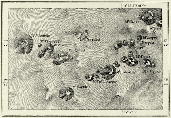
Fig. 122.—THE CENTRAL PORTION OF THE ÆOLIAN ISLANDS.
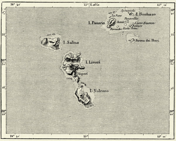
Lipari is a land of promise to the geologist, on account of the great variety of its lavas. Monte della Castagna is wholly composed of obsidian. Another hill, Monte Bianco, consists of pumice, and, when seen from a distance, has the appearance of being covered with snow. The streams of pumice which fill every ravine extend down to the sea, and the water is covered with this buoyant stone, which drifts sometimes as far as Corsica. Lipari supplies nearly the whole of Europe with pumice.113
Vulcano, to the south of Lipari, from which it is separated by a strait less than a mile across, contrasts strangely with its smiling neighbour. Vulcano, with the exception of a few olives and vines growing on the southern slopes, consists wholly of naked scoriæ, and this circumstance probably led to its being dedicated to Vulcan. Most of its rocks are black or of a reddish hue like iron, but there are {333} others which are scarlet, yellow, or white. At the northern extremity of the island rises the Vulcanello, a small cone which appeared above the surface of the sea nobody knows when, and which an isthmus of reddish cinders united about the middle of the thirteenth century to the principal volcano of the island. This central mountain of the island has a crater about 1,800 yards in circumference, from which steam continually escapes. The atmosphere is charged with sulphurous vapours difficult to breathe. From hundreds of small orifices jets of steam make their escape with a throbbing and hissing noise. Some of these fumaroles have a temperature of 610° F. Jets of a lower temperature are met with in other parts of the island, and even at the bottom of the bay. Violent eruptions are rare, and in the eighteenth century only three occurred. The last eruption took place in 1873, after a repose of a hundred years. Until recently the only inhabitants of Vulcano were a few convicts, who collected sulphur and boracic acid, and manufactured a little alum. But an enterprising Scotchman has now taken possession of this grand chemical laboratory. He has built a large manufactory near the port, and a few trees planted around his Moorish residence have somewhat improved the repulsive aspect of the country.
Stromboli, though smaller than either Lipari or Vulcano, is nevertheless more celebrated, on account of its frequent eruptions. For ages back scarcely any mariners have passed this island without seeing its summit in a state of illumination. At intervals of five minutes, or less, the seething lava filling its caldron bubbles up, explosions occur, and steam and stones are ejected. These rhythmical eruptions form a most agreeable sight, for there is no danger about them, and the olive groves of the Stromboliotes have never been injured by a stream of lava. The volcano, however, has its moments of exasperation, and its ashes have frequently been carried to the coast of Calabria, which is more than thirty miles off.
Panaria and the surrounding group of islands between Stromboli and Lipari have undergone many changes, if Dolomieu and Spallanzani are correct in saying that they originally formed only a single island, which was blown into fragments by an eruption having its centre near the present island of Dattilo. A hot spring and an occasional bubbling up of the sea-water prove that the volcanic forces are not yet quite extinct.
As regards the small eastern islands of the archipelago, Salina, Felicudi, and Alicudi, the last of which resembles a tent pitched upon the surface of the water, history furnishes no records of their ever having been in any other than a quiescent state. The island of Ustica, about thirty miles to the north of Palermo, is likewise of volcanic origin, but is not known ever to have had an eruption. It is one of the most dreaded places of exile in Italy. Near it is the uninhabited island of Medico, the ancient Osteodes, where the mercenaries deserted by the Carthaginians were left to die of starvation. {334}
THE ÆGADIAN ISLANDS.
Off the western extremity of Sicily lie shallows, sand-banks, and calcareous islands of the same composition as the adjoining mainland. These are the Ægades, or Goat Islands, named after the animals which climb their steep escarpments. Favignana, near which the Romans won the naval victory which terminated the first Punic war, is the largest of these islands. Its steep cliffs abound in caverns, in which heaps of shells, gnawed bones, and stone implements have been found, dating back to the contemporaries of the mammoth and the antediluvian bear. Conflicts between contrary winds are frequent in this labyrinth of rocks and shoals, and the power of the waves is much dreaded. The tides are most irregular, and give rise to dangerous eddies. The sudden ebb, locally known as marubia, or “tipsy sea” (mare ubbriaco?), has been the cause of many shipwrecks.
Μ
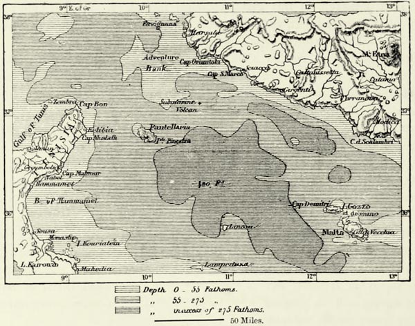
Fig. 123.—THE MEDITERRANEAN TO THE SOUTH OF SICILY.
Scale 1 : 4,000,000.
PANTELLARIA.
Pantellaria rises in the very centre of the strait which unites the Western Mediterranean with the Eastern. The island is of volcanic origin, abounds in thermal springs, and, above all, in steam jets. Placed on a great line of navigation, Pantellaria might have become of importance if it had possessed a good harbour like Malta. To judge from certain ruins, the population was more considerable {335} formerly than it is now. There exist about a thousand odd edifices, called sesi by the inhabitants, which are supposed to be ancient dwellings. Like the nuraghi of Sardinia, they have the shape of hives, and are built of huge blocks of rock without mortar. Some of them are twenty-five feet high and forty-five feet wide; and Rossi, the archæologist, thinks that they date back to the stone age, for pieces of worked obsidian have been found in them.
From the top of Pantellaria we are able to distinguish the promontories on the Tunisian coast, but, though it is nearer to Africa than to Europe, the island nevertheless belongs to the latter continent, as is proved by the configuration of the sea-bottom. This cannot be said of Linosa, an island with four volcanic peaks to the west of Malta, and still less of the Pelagian Islands. The latter, consisting of Lampedusa and a satellite rock called Lampion, owe their name (Lamp-bearer and Lamp) to the light which, legend tells us, was kept burning by a hermit or angel for the benefit of mariners. In our own days this legendary lamp has been superseded by a small lighthouse marking the entrance to the port of Lampedusa, where vessels of three or four hundred tons find a safe shelter.
About the close of the eighteenth century the Russians proposed to establish a military station on Lampedusa to rival that of Malta, but this project was never carried out, and has not been taken up by the Italian Government. The population consists of soldiers, political exiles, criminals, and a few settlers, who speak Maltese.114
MALTA AND GOZZO.
Malta, though a political dependency of Great Britain, belongs geographically to Italy, for it rises from the same submarine plateau as Sicily. About fifty miles to the east of the island the depth of the sea exceeds 1,500 fathoms, but in the north, in the direction of Sicily, it hardly amounts to eighty, and there can be no doubt that an isthmus formerly united Malta to continental Europe. Geologists are agreed that the land of which Malta and Gozzo are now the only remains must formerly have been of great extent, for amongst the fossils of its most recent limestone rocks have been found the bones of elephants and other animals which only inhabit continents. Even now the island is slowly wasting away, and its steep cliffs, pierced by numerous grottoes, locally known as ghar, are gradually crumbling into dust.
Placed in the very centre of the Mediterranean, and possessed of an excellent port, Malta has at all times been a commercial station of much importance. It has been occupied by all the nations who succeeded each other in the possession of the Mediterranean—Phœnicians, Carthaginians, Romans, and Greeks. But long before that time the island must have been inhabited, for we meet with grottoes excavated in the rocks, and with curious edifices resembling the nuraghi of Sardinia, and it is just possible that the descendants of these aborigines still {336} constitute the principal element of the existing population, which, at all events, is very mixed, and during the domination of the Saracens almost became Arab. The language spoken is a very corrupt Italian, containing many Arabic words.
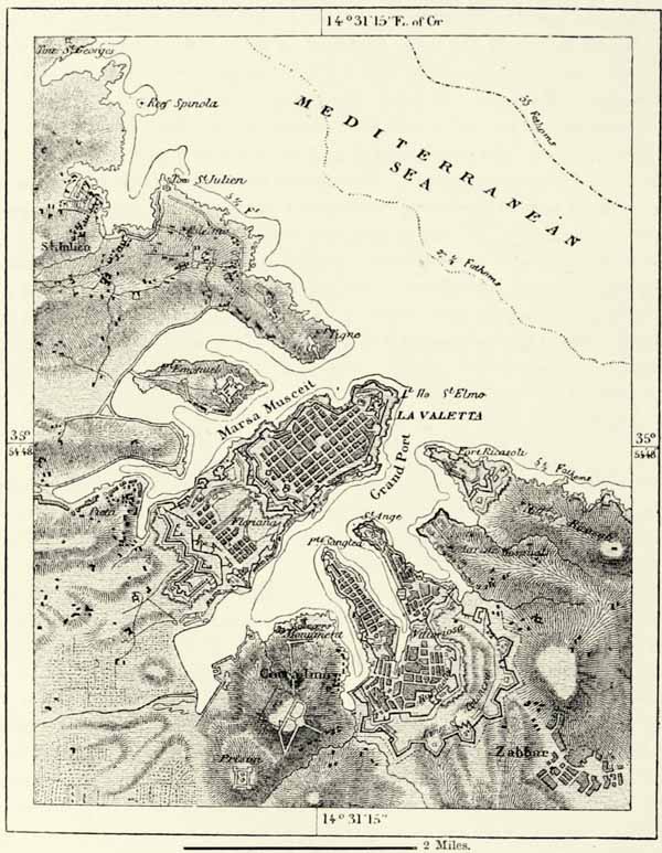
Μ
Fig. 124.—THE PORT OF MALTA.
Scale 1 : 49,000.
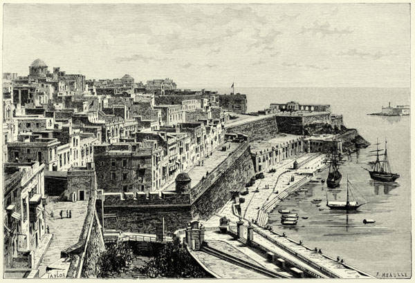
LA VALETTA, MALTA.
The great military part played by Malta began when the Knights of St. John, after their expulsion from Rhodes in 1522, installed themselves upon the island, and converted it into the bulwark of the Christian world. In the beginning of this century Malta passed into the possession of the English, who may survey thence, as from a watch-tower, the whole of the Mediterranean, from Gibraltar to Smyrna {337} and Port Said. The excellent port of La Valetta singularly facilitates the military and commercial part which Malta is called upon to play in the world of the Mediterranean. It is sufficiently spacious to shelter two entire fleets, and its approaches are defended by fortifications rendered impregnable by the successive work of three centuries. There are, besides, all the facilities required by merchantmen, including a careening dock larger than any other in the world. The commerce of the island is rapidly increasing; it is one of the great centres of steamboat navigation, and submarine telegraphs connect it with all parts of the world.115
The city of La Valetta has retained all its ancient picturesqueness, in spite of its straight streets and the walls which surround it. Its high white houses, ornamented with balconies and conservatories, rise amphitheatre-like on the slope of a hill; stairs lead from landing-place to landing-place to the summit of this hill; and from every street we behold the blue sea, with its large merchantmen and crowds of smaller vessels. Gondolas, having two huge eyes painted upon the prow, glide noiselessly over the waters, and curious vehicles roll heavily along the quays. Maltese, English soldiers, and sailors of every nation crowd the streets. Now and then a woman glides rapidly along the walls. Like all Christian women of the East, she wears the faldetta, a sort of black silk domino, which hides her sumptuous dress, and coquettishly conceals her features.
Malta beyond the walls of the town is but a dreary place of abode. The country rises gently towards the south, in the direction of Città Vecchia and the hills of Ben Gemma. Grey rocks abound, a fine dust covers the vegetation, and the white walls of the village glisten in the sun. There are no trees, except in a few solitary gardens, where the famous mandarin oranges grow. Nor are there any rivers. The soil is scorched, and it is matter for astonishment that it should yield such abundant harvests of cereals, and clover (sulla) growing to the height of a man. Carnation tints delight the eye during the season of flowers. The Maltese peasants, small, wiry, and muscular, are wonderfully industrious. They have brought the whole island under cultivation, the cliffs alone excepted, and, where vegetable soil is wanting, they produce it artificially by triturating the rocks. In former times vessels coming from Sicily were bound to bring a certain quantity of soil as ballast. But in spite of their careful cultivation, the inhabitants of Malta, Gozzo, and Comino (thus named from cumin, which, with cotton, is the principal crop of the island), the produce hardly suffices for six months’ consumption, and the islanders are largely dependent upon Sicily for their food. Navigation and the fisheries contribute likewise towards the means of subsistence, but the Maltese would nevertheless perish on their island if the surplus population did not emigrate to all the coast lands of the Mediterranean, and especially to Algeria, where the Maltese, as everywhere else, are distinguished for thrift and industry. {338}
In winter this exodus is in some measure compensated for by the arrival of many English families, who visit the island for the sake of its dry and mild climate. February is the finest month, and the island is then resplendent with verdure, but the scorching heat of summer soon dries up the vegetation.
A governor appointed by the Crown exercises executive functions, and enjoys the privilege of mercy. He is assisted by a Council of seven members, by whom all laws are discussed and voted. The lord-lieutenant of each district is chosen amongst the Maltese nobles, and deputies appointed by the governor manage the affairs of the villages. Italian is the language used in the courts, with the exception of the Supreme Court, into which English was introduced in 1823.
The revenues of the island, about £170,000 annually, are not sufficient to cover the military expenses, and the deficiency is made up by the imperial treasury.
Most of the inhabitants are Roman Catholics. The bishop is appointed by the Pope, and enjoys an income of £4,000.116
VIII.—SARDINIA.
It is a curious fact that an island so fertile as Sardinia, so rich in metals, and so favourably situated in the centre of the Tyrrhenian Sea, should have lagged behind in the race of progress as it has. When the Carthaginians held that island its population was certainly more numerous than it is now, and the fearful massacres placed on record by the historians of Rome testify to this fact. Its decadence was sudden and thorough. In part it may be accounted for by the configuration of the island, which presents steep cliffs towards Italy, whence emigrants might have arrived, whilst its western coast is bounded by marshes and insalubrious swamps. But the principal cause of this torpor, which endured for centuries, is traceable to the actions of man. The conquerors who succeeded the Romans and Byzantines in the possession of the island, whether Saracens, Pisans, Genoese, or Aragonese, monopolized its produce solely with a view to their own profit, and further mischief was wrought by the pirates of Barbary, who frequently descended upon its coasts. As recently as 1815 the Tunisians landed upon Sant’ Antioco, massacring the inhabitants, or carrying them into slavery. The coast districts became depopulated, and the inhabitants retired to the interior, where, oppressed by their feudal lords, they led a life of isolation from the rest of Europe. It is hardly a generation since Sardinia began to participate in the general progress made throughout Italy.
Μ
Fig. 125.—THE SEA TO THE SOUTH OF SARDINIA.
Scale 1 : 2,000,000.
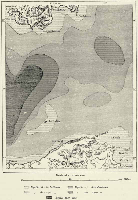
Sardinia is nearly as large as Sicily, but has only a fourth of its population.117 Geographically it is more independent of Italy than the southern island, and a profound sea, more than 1,000 fathoms in depth, divides it from the African continent. Sardinia with Corsica forms a group of twin islands, which is separated from the Tuscan archipelago by a narrow strait only 170 fathoms in depth. {339} The geological structure of the two islands is identical, and there can be no doubt that the islands and rocks in the Strait of Bonifacio are the remains of an isthmus destroyed by the sea. On the other hand, we learn from a study of the geology of Sardinia that at a period not very remote that island must have consisted of several separate islands. The principal island formed a southerly continuation {340} of the mountains of Corsica, whilst the smaller ones lay to the west. Alluvial deposits, volcanic eruptions, and perhaps, also, an upheaval of the soil, have converted the shallow straits which separated them into dry land.
The mountains of Sardinia may be said to begin with the islands of Maddalena and Caprera, in the Strait of Bonifacio, and in the mountain mass of the Gallura they attain already a considerable height. A depression separates these from the southern portion of the great back-bone of the island, which stretches along the whole of the eastern coast, and terminates abruptly at Cape Carbonaro. These mountains, like those of Corsica, consist of crystalline rocks and schists; but whilst the slope on the latter island is steepest towards the west, the reverse is the case on Sardinia, and that island may almost be said to turn its back upon Italy. The general slope of the island is towards the west, and its occupation by Spain could therefore be justified by purely geographical arguments.
Μ
Fig. 126.—THE STRAIT OF BONIFACIO.
Scale 1 : 300,000.
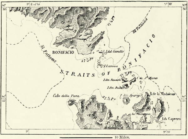
The highest summits of the island are found in the central portion of this crystalline chain, where the Gennargentu, or “silver mountain,” rises to a height of 6,116 feet. A little snow remains in the crevices of this mountain throughout the summer. The inhabitants of Northern Sardinia formerly imagined that their own Gigantinu, or “giant,” in the mountains of Limbarra, constituted the culminating point of the island, but careful measurements have shown that that superb peak only attains an elevation of 4,297 feet.
The secondary mountain groups in the western portion of the island are separated from the main chain by recent geological formations. The granitic {341} region of La Nurra, to the west of Sassari, almost uninhabited in spite of its fertile valleys, and the island of Asinara adjoining it, which abounds in turtles, are amongst these insulated mountain regions. Another, intersected by the beautiful valley of Domus Novas, occupies the south-western extremity of the island. Geologists look upon it as the most ancient portion of the island, and the plain of Campidano, which now occupies the site of an ancient arm of the sea, is of quaternary formation. The transversal range of Marghine occupies the centre of the island, and there, too, we meet with vast limestone plateaux pierced by volcanic rocks. The ancient craters, however, no longer emit lava, nor even gases, and the villagers have tranquilly built their huts within them. Thermal springs alone indicate the existence of subterranean forces. Volcanic cones of recent age are met with in the north-western portion of the island, as well as in the valley of the Orosei, on the east coast. The trachytic rocks of the islands of San Pietro and Sant’ Antioco are of greater age. They sometimes present the appearance of architectural piles, especially at the Cape of Columns, which is, however, rapidly disappearing, as the stone is being quarried to be converted into pavement. On Sant’ Antioco, which a bridge joins to the mainland, there are deep caverns, the haunts of thousands of pigeons, which are caught by spreading a net before their entrance.
In addition to the changes wrought by volcanic agencies, Sardinia exhibits traces of a slow upheaval or subsidence due to the expansion or contraction of the upper strata of the earth. Raised beaches have been discovered by La Marmora near Cagliari, at an elevation of 243 and 322 feet above the sea-level, where shells of living species are found together with potsherds and other articles, proving that when this upheaval took place the island was already inhabited. Elsewhere there exist traces of a subsidence, and the old Phœnician cities of Nora, to the south-west of Cagliari, and Tharros, on the northern peninsula of the Gulf of Oristano, have become partly submerged.
Amongst the rivers of the island there is only one which deserves that name. This is the Tirso, or Fiume d’Oristano, which is fed by the snows of the Gennargentu and the rains which descend on the western mountain slopes. Other rivers of equal length are hardly more than torrents, which at one time invade the fields adjoining them, and at another shrink to a thin thread of water meandering between thickets of laurel-trees. Most of the river beds are dry during eight months of the year, and even after rain the water does not find its way into the sea, but is absorbed by the littoral swamps.
All these swamps have brackish water. The largest amongst them communicate freely with the sea, at least during the rainy season, but others are separated from it by a strip of sand. But these, too, are brackish, for the sea-water percolates through the soil, and keeps them at the same level. The water of the inland swamps is likewise saturated with saline substances derived from the surrounding soil. They generally dry up in summer, but the coating of salt which then appears is hardly dry enough to repay the labour of collection and refinement. The only salt marshes actually exploited are those of Cagliari and of Carlo-Forte, on San {342} Pietro. They have been leased to a French company, and yield annually nearly 120,000 tons of salt.
Swamps and marshes envelop nearly the whole of the island in a zone of miasmata, which are carried by the wind into the interior, producing fever even in the more elevated mountain districts. There are localities on the island the air of which no stranger can breathe with impunity. The coast districts of Sardinia, with their stagnant waters, are, in truth, the most unhealthy in Italy, and quite one-fourth of the area of the island is exposed to the scourge of malaria, which sufficiently accounts for the small population of the island and the little progress made.
Even when Sardinia was at the height of its prosperity, and supplied Rome with an abundance of corn, cheese, pork, lead, copper, iron, and textile fabrics, it was noted for its unhealthiness, and the emperors exiled to it those whom they desired to get rid of. Then, as now, the landed proprietors, about the middle of June, retired to the towns, the walls of which offered some protection against the poisonous air. The Italian Government officials are sent to the island as a punishment, and for the most part look upon themselves as condemned to death. Even the native villagers are bound to observe the greatest precautions, and wear garments of skin or leather which are impenetrable to rain, mist, and dew. They are dressed most warmly during the hottest part of the year as a protection against the climate, and in their long mastrucas of sheepskin they almost look like Wallachian herdsmen.
Ancient geographers, as well as the Sardinians themselves, ascribe the unhealthiness of the climate to the rarity of north-easterly winds. The mountains of Limbarra, in the north of the island, are popularly supposed to act as a sort of screen, which diverts this health-bringing wind, to the great detriment of Lower Sardinia; and there appears to be much truth in this popular notion. South-westerly winds, or libeccios, are almost equally rare, and when they blow they do so with tempestuous violence.
The regular winds of Sardinia blow from the north-west or south-east. The former is known as the maestrale, the latter as the levante or sirocco, called maledetto levante by the inhabitants of Southern Sardinia. It becomes charged with moisture during its passage across the Mediterranean, and its temperature is in reality much less than might be supposed from the lassitude produced by it. The maestrale, on the other hand, is hailed with joy, for it is an invigorating wind. On reaching the coast it generally parts with its moisture, and when it arrives at Cagliari it is perfectly dry. The capital of Sardinia is indebted to this wind and to sea breezes for its low temperature (62·4° F.), which is far lower than that of Genoa.
Hurricanes are comparatively rare, and hailstorms, which work such damage elsewhere, are hardly known. Most of the rain falls in autumn; it ceases in December, when the pleasantest season sets in. These are the “halcyon days” of ancient poets, when the sea calms down in order that the sacred bird may build his nest. But these pleasant days are succeeded by a wretched spring. February, the “double-faced month” of Sardinian mariners, brings capricious frosts, to which {343} succeed, in March and April, abrupt changes of temperature, winds, and rain. Vegetation in consequence is far more backward than might be supposed from the latitude.
The vegetation of Sardinia resembles that of the other islands of the Mediterranean. The forest in the highland valleys of the interior and on the trackless mountain slopes consists of pines, oaks, and holm-oaks, mixed here and there with yoke-elms and maples. The villages are surrounded by chestnut-trees and groves of magnificent walnut-trees. The hill-tops, robbed of their forests, are covered with odoriferous plants and thickets of myrtles, strawberry-trees, and heather. It is there the bees collect the bitter honey so much despised by Horace. Vast tracts of uncultivated land near the seashore are covered with wild olive-trees, which only need grafting to yield excellent fruit. All the fruit trees and useful plants of the Mediterranean flourish in Sardinia. Almond and orange trees, introduced by the Moors at the close of the eleventh century, flourish vigorously. The orange groves of Millis, which are protected by the extinct volcano of Monte Ferru, are, perhaps, the most productive on the shores of the Mediterranean, and in good seasons yield 60,000,000 oranges. The gardens of Domus Novas, Ozieri, and Sassari are of surprising fertility. In the southern part of the island, wherever the cultivated fields gain upon the lands covered with rock-roses, fennel, and lilies, they are fenced in with fig-trees. The fan-shaped foliage of the date-palm is seen near every town, and more especially in the environs of Cagliari. By a curious contrast the dwarf palm is not met with in the southern lowlands of the island, though their climate is almost African, but forms dense thickets in the solitudes of Alghero, in the north of the islands. The inhabitants eat the roots of this tree, as do also the Moors.
Although all the plants of neighbouring countries become easily acclimatized in Sardinia, that island is naturally poorer in species than are continental regions lying under the same latitude. There is nothing special about its flora, for the island is probably only a remnant of a larger tract of land which formerly joined Europe to Africa. As to the famous plant mentioned by ancient writers, which, eaten by mistake, produced fits of “sardonic laughter,” or even death, it does not appear to be peculiar to the island. Mimaut thinks, from the descriptions of Pliny and Pausanias, that the large-leafed water-parsley (Sium latifolium) is referred to.
The number of species of animals, like that of plants, is smaller in Sardinia than on the neighbouring continent. There are neither bears, badgers, polecats, nor moles. Vipers or venomous serpents of any description do not exist, and the only animal to be dreaded is the tarentula (arza, or argia), a sting from which can be cured only by dancing until completely exhausted, or by immersion in dung. The ordinary frog, though common in Corsica, does not exist, but European butterflies are numerous. The moufflon, which is, perhaps, the ancestor of our domestic sheep, and has been exterminated in nearly all the islands of the Mediterranean, still lives in the mountains of Corsica and Sardinia. Wild horses roamed over Sant’ Antioco as recently as the beginning of this century; myriads {344} of rabbits burrow in the small islands lining the coast; and wild goats with long horns and yellow teeth inhabit the limestone island of Tavolara, in the Gulf of Terranova. These goats are descended from domestic animals abandoned at some former period. Caprera, the residence of Garibaldi, is named after the goats which formerly inhabited it, and animals of that kind recently introduced there quickly returned to a state of nature.
Naturalists have observed that the mammals of Sardinia are smaller than the same species living on the continent. The goat is the only exception to the rule. The stag, deer, wild boar, fox, wild cat, hare, rabbit, marten, and weasel are all of them smaller than the continental varieties. The same rule applies to domesticated animals, with the exception of the pig, which grows to a great size, especially where it is allowed to roam through oak forests. There is a variety of this animal whose hoofs are not cloven, and which ought, therefore, to be classed amongst solipeds. The horses and asses of Sardinia are dwarfs. But the horse is distinguished by great sobriety, sureness of foot, vigour, and endurance. If in addition to these advantages it possessed a more attractive exterior, it would rank among the most highly appreciated horses of Europe. As to the donkeys, though hardly larger than a mastiff, they are brave little animals, and frequently share with their masters the only room of their abode. The old-fashioned mills, resembling in every respect the Roman bas-reliefs which may be seen in the Vatican, are propelled by these donkeys, which thus materially contribute towards the support of their proprietors.
Sardinia abounds more than any other country of Western Europe in prehistoric remains. There are megaliths, known as “giants’ stones,” “altars,” or “long-stones,” as in Brittany, scarcely any of them showing traces of the chisel. Dolmens, however, are rare, and the genuineness of all is doubted. Amongst these monuments there are, perhaps, some which were connected with the worship of some Eastern deity, for Phœnicians and Carthaginians stayed for a considerable time upon the island, where they founded Caralis, Nora, Tharros, and other towns; and even during the time of the Romans it was customary to place Punic inscriptions upon the tombstones. The ruins of Tharros have yielded golden idols and other articles in large numbers, most of them being of Egyptian origin. But the principal witnesses to the civilisation of the ancient Sards are the curious structures known as nuraghi. They generally occupy the hill-tops, and, seen from a distance, resemble pyramids. The limestone plateau of Giara, near the centre of the island, is surrounded by masonry structures of this description, which abound also in other portions of the island, the number still existing being nearly 4,000. They are most numerous in the basaltic region to the south of Macomer, and are met with for the most part in fertile districts, far away from the arid steppes.
The origin and uses of these nuraghi have been a subject of much discussion, but archæologists now almost universally adopt the views of Signor Spano, the indefatigable explorer of Sardinian antiquities. According to him these nuraghi were dwellings, and their Phœnician name simply means “round house.” The rudest {345} among them, dating back probably for forty centuries, contain but a single chamber. They were erected during the age of stone, when man first gave up his cavern dwellings. The more recent constructions date back to the age of bronze, and even of iron. More skill is exhibited in their structure, though no mortar has been used, and they contain two or more chambers, forming as many floors, and accessible by means of stone stairs. The ground floor of some is large enough for the accommodation of forty or fifty persons, and is furnished with antechambers and small semicircular recesses. The nuraghi of Su Domu or S’Orcu, near Domus Novas, which has recently been demolished, contained ten chambers and four courtyards; it was a fortress as well as a dwelling-place, capable of accommodating a hundred persons and standing a siege. The dwellings of the modern Albanians and of the Swaneti in the Caucasus still resemble these ancient abodes.