GREECE.
Reading edition

I.—GENERAL ASPECTS.
REECE, within its confined political boundaries, to the south of the Gulfs of Arta and Volo, is a country of about nineteen thousand square miles, or at most equal to the ten-millionth part of the earth’s surface. Within the vast empire of Russia there are many districts more extensive than the whole of Greece, but there is nothing which distinguishes these from other districts which surround them, and their names call forth no idea in our mind. The little country of the Hellenes, however, so insignificant upon our maps—how many memories does it not awaken ! In no other part of the world had man attained a degree of civilisation equally harmonious in all respects, or more favourable to individual development. Even now, though carried along within an historical cycle far more vast than that of the Greeks, we should do well to look back frequently in order to contemplate those small nations, who are still our masters in the arts, and first initiated us into science. The city which was the “school of Greece” still remains the school of the entire world; and after twenty centuries of decay, like some of those extinct stars whose luminous rays yet reach the earth, still continues to enlighten us.
The considerable part played by the people of Greece during many ages must undoubtedly be ascribed to the geographical position of their country. Other tribes having the same origin, but inhabiting countries less happily situated—such, for instance, as the Pelasgians of Illyria, who are believed to be the ancestors of the Albanians—have never risen above a state of barbarism, whilst the Hellenes placed themselves at the head of civilised nations, and opened fresh paths to their enterprise. If Greece had remained for ever what it was during the tertiary geological epoch—a vast plain attached to the deserts of Libya, and run over by lions and the rhinoceros—would it have become the native country of a Phidias, an Æschylos, or a Demosthenes? Certainly not. It would have shared the fate of Africa, and, far from taking the initiative in civilisation, would have waited for an impulse to be given to it from beyond. {37}
Greece, a sub-peninsula of the peninsula of the Balkans, was even more completely protected by transverse mountain barriers in the north than was Thracia or Macedonia. Greek culture was thus able to develop itself without fear of being stifled at its birth by successive invasions of barbarians. Mounts Olympus, Pelion, and Ossa, towards the north and east of Thessaly, constituted the first line of formidable obstacles towards Macedonia. A second barrier, the steep range of the Othrys, runs along what is the present political boundary of Greece. To the south of the Gulf of Lamia a fresh obstacle awaits us, for the range of the Œta closes the passage, and there is but the narrow pass of the Thermopylæ between it and the sea. Having crossed the mountains of the Locri and descended into the basin of Thebæ, there still remain to be crossed the Parnes or the spurs of the Cithæron before we reach the plains of Attica. The “isthmus” beyond these is again defended by transverse barriers, outlying ramparts, as it were, of the mountain citadel of the Peloponnesus, that acropolis of all Greece. Hellas has frequently been compared to a series of chambers, the doors of which were strongly bolted; it was difficult to get in, but more difficult to get out again, owing to their stout defenders. Michelet likens Greece to a trap having three compartments. You entered, and found yourself taken first in Macedonia, then in Thessaly, then between the Thermopylæ and the isthmus. But the difficulties increase beyond the isthmus, and Lacedæmonia remained impregnable for a long time.
At an epoch when the navigation even of a land-locked sea like the Ægean was attended with danger, Greece found herself sufficiently protected against the invasions of oriental nations; but, at the same time, no other country held out such inducements to the pacific expeditions of merchants. Gulfs and harbours facilitated access to her Ægean coasts, and the numerous outlying islands were available as stations or as places of refuge. Greece, therefore, was favourably placed for entering into commercial intercourse with the more highly civilised peoples who dwelt on the opposite coasts of Asia Minor. The colonists and voyagers of Eastern Ionia not only supplied their Achæan and Pelasgian kinsmen with foreign commodities and merchandise, but they also imparted to them the myths, the poetry, the sciences, and the arts of their native country. Indeed, the geographical configuration of Greece points towards the east, whence she has received her first enlightenment. Her peninsulas and outlying islands extend in that direction; the harbours on her eastern coasts are most commodious, and afford the best shelter; and the mountain-surrounded plains there offer the best sites for populous cities. Greece, at the same time, does not share the disadvantage of Turkey, which is almost cut off from the western world by a mountain region difficult to cross. The Ionian Sea, to the west of the Peloponnesus, it is true, is, comparatively speaking, a desert; but farther north the Gulf of Corinth almost cuts in two the Greek peninsula, and the sight of the distant mountains of Italy, which are visible from the Ionian Islands, must have incited to an exploration of the western seas. The Acarnanians, who knew how to build vaults long before the Romans, were thus brought early into contact with the Italians, to whom they imparted their {38} knowledge, and at a subsequent period the Greeks became the civilisers of the whole western world of the Mediterranean.
The most distinctive feature of Hellas, as far as concerns the relief of the ground, consists in the large number of small basins, separated one from the other by rocks or mountain ramparts. The features of the ground thus favoured the division of the Greek people into a multitude of independent republics. Every town had its river, its amphitheatre of hills or mountains, its acropolis, its fields, pastures, and forests, and nearly all of them had, likewise, access to the sea. All the elements required by a free community were thus to be found within each of these small districts, and the neighbourhood of other towns, equally favoured, kept alive perpetual emulation, too frequently degenerating into strife and battle. The islands of the Ægean Sea, likewise, had constituted themselves into miniature republics. Local institutions thus developed themselves freely, and even the smallest island of the Archipelago has its great representatives in history.
But whilst there thus exists the greatest diversity, owing to the configuration of the ground and the multitude of islands, the sea acts as a binding element, washes every coast, and penetrates far inland. These gulfs and numerous harbours have made the maritime inhabitants of Greece a nation of sailors—amphibiæ, as Strabo called them. From the most remote times the passion for travel has always been strong amongst them. When the inhabitants of a town grew too numerous to support themselves upon the produce of their land, they swarmed out like bees, explored the coasts of the Mediterranean, and, when they had found a site which recalled their native home, they built themselves a new city. It was thus Greek cities arose in hundreds of places, from the Mæotis Palus to beyond the columns of Hercules—from Tanais and Panticapæum to Gades and Tingis, the modern Tangier. Thanks to those numerous colonies, some of them more powerful and renowned than the mother towns which gave birth to them, the veritable Greece, the Greece of science and art and republican independence, in the end overflowed its ancient cradle, and sporadically occupied the whole circumference of the Mediterranean. The Greeks held the same position relatively to the world of the ancients which is occupied at the present time by the Anglo-Saxons with reference to the entire earth. There exists, indeed, a remarkable analogy between Greece, with its archipelago, and the British Islands, at the other extremity of the continent. Similar geographical advantages have brought about similar results, as far as commerce is concerned, and between the Ægean and the British seas time and space have effected a sort of harmony.
The admiration with which travellers behold Greece is due, above all, to the memories attaching to every one of its ruins, to the smallest amongst its rivulets, and the most insignificant rock in its seas. Scenery in Provence or Spain, though it may surpass in grace or boldness of outline anything to be seen in Greece, is appreciated only by a few. The mass go past it without emotion, for names like Marathon, Leuctra, or Platææ are not connected with it, and the rustle of bygone ages is not heard. But even if glorious memories were not associated with the {39} coasts of Greece, their beauty would nevertheless entitle them to our admiration. In the gulfs of Athens or of Argos the artist is charmed not only with the azure blue of the waters, the transparency of the sky, the ever-changing perspective along the shores, and the boldness of the promontories, but also with the pure and graceful profile of the mountains, which consist of layers of limestone or of marble. We almost fancy we look upon architectural piles; and the temples with which many a summit is adorned appear to epitomize them.
It is verdure and the sparkling water of rivulets which we miss most on the shores of Greece. Nearly all the mountains near the coast have been despoiled of their large trees. There remain only bushes, mastic, strawberry, and juniper trees, and evergreen oaks; even the carpet of odoriferous herbs which clothes the declivities, and upon which the goat browses, has in many instances been reduced to a few miserable patches. Torrents of rain have carried away the mould, and the naked rock appears on the surface. From a distance we only see greyish declivities, dotted here and there with a few wretched shrubs. Even in the days of Strabo most mountains along the coasts had been robbed of their forests, and one of our modern authors says that “Greece is a skeleton only of what it used to be !” By a sort of irony, geographical names derived from trees abound throughout Hellas and Turkey: Caryæ is the “town of walnut-trees,” Valanidia that of the Valonia oaks, Kyparissi that of cypresses, Platanos or Plataniki that of plane-trees. Everywhere we meet with localities whose appellation is justified by nothing. Forests at the present day are confined almost entirely to the interior and to the Ionian coast. The Œta Mountains, some of the mountains of Ætolia, the hills of Acarnania, and Arcadia, Elis, Triphylia, and the slopes of the Taygetus, in the Peloponnesus, still retain their forests. And it is only in these forest districts, visited solely by herdsmen, that savage animals, such as the wolf, the fox, and the jackal, are now met with. The chamois, it is said, still haunts the recesses of the Pindus and Œta Mountains; but the wild boar of the Erymanthus, which must have been a distinct species if we are to judge by antique sculptures, exists no more in Greece, and the lion, still mentioned by Aristotle, has not been seen for two thousand years. Amongst the smaller animals there is a turtle, common in some parts of the Peloponnesus, which the natives look upon with the same aversion as do many western nations upon the toad and the salamander.
Greece is a small country, but the variety of its climate is nevertheless great. Striking differences in the climate of different localities are produced by the contrasts between mountains and plains, woodlands and sterile valleys, coasts having a northern or southern aspect. But even leaving out of sight these local differences, it may safely be asserted that the varieties of climate which we meet with in traversing Greece from north to south are scarcely exceeded in any other region. The mountains of Ætolia, in the north, whose slopes are covered with beech-trees, remind us of the temperate zone of Europe, whilst the peninsulas and islands towards the east and south, with their thickets of fig and olive trees, their plantations of oranges and lemons, their aloe hedges and rare palm-trees, belong to the sub-tropical zone. But even neighbouring districts occasionally {40} differ strikingly as regards climate. In the ancient lake basin of Bœotia the winters are cold, the summers scorching, whilst the temperature of the eastern shore of Eubœa is equable, owing to the moderating influence of sea breezes. Within a narrow compass Greece presents us with the climates of a large portion of the earth, and there can be no doubt that this diversity of climate, and the contrasts of every kind springing from it, must have favourably influenced the intellectual development of the Hellenes. A spirit of inquiry was called forth amongst them which reacted upon their commercial tastes and industrial proclivities.
The diversity of the climate of the land, however, is compensated for, in Greece, by a uniformity in the climate of the maritime districts. As in a mountain valley, the winds of the Ægean Sea blow alternately in contrary directions. During nearly the whole of summer the atmospheric currents of Eastern Europe are attracted towards the African deserts. The winds from the north of the Archipelago and Macedonia then speed the navigator on his voyage to the south, and on many occasions the conquering tribes of the northern shores of that sea have availed themselves of them in their improvised attacks upon the inhabitants of the more southern districts of Asia Minor and of Greece. These regular northerly currents, known as etesian or annual winds, cease on the termination of the hot season, when the sun stands above the southern tropic. They are, moreover, interrupted every night, when the cool sea air is attracted by the heated surface of the land. When the sun has set the wind gradually subsides; there is a calm, lasting a few moments; and then the air begins to move in an inverse direction—“the land begins to blow,” as the sailors say. Nor is this regular wind without its counter-current, known as the embates, or propitious south-easterly breeze of which the poets sing. General winds and breezes, moreover, are deflected from their original directions in consequence of the configuration of the coast and the direction of mountain chains. The Gulf of Corinth, for instance, is shut in by high mountains on the north and the south, and the winds alternately enter it from the east or west—a phenomenon likened by Strabo to the breathing of an animal.
The rains, like the winds, deviate in many places from the average, and whilst the water pours down into some mountain valleys as into a funnel, elsewhere the clouds drift past without parting with a drop of their humid burden. Contrasts in the amount of precipitation are thus added to those resulting from differences of configuration and variety of climate. As a rule, rain is more abundant on the western shores of Greece than on the eastern, and this fact accounts for the smiling aspect of the hills of Elis, as compared with the barren declivities of Argolis and Attica. Thunder-storms, driven before the winds of the Mediterranean, likewise recur with greater regularity in the western portion of the peninsula. In Elis and Acarnania the roll of thunder may be heard in spring daily, for whole weeks, in the afternoon. No sites more apposite could have been found for temples dedicated to Jupiter, the god of lightning.
The ancient inhabitants of the Cyclades, and probably, also, those of the coasts {41} of Hellas and Asia Minor, had already attained a considerable amount of culture long before the commencement of our historical records. This has been proved by excavations made in the volcanic ashes of Santorin and Therasia. At the time their houses were buried beneath the ashes, the Santoriniotes had begun to pass from the age of stone into that of copper. They knew how to build arches of stone and mortar, they manufactured lime, used weights made of blocks of lava, wove cloth, made pottery, dyed their stuffs, and ornamented their houses with frescoes; they cultivated barley, peas, and lentils, and had begun to trade with distant countries.
We do not know whether these men were of the same race as the Hellenes; but thus much is certain—that at the earliest dawn of history the islands and coasts of the Ægean Sea were peopled by various families of Greeks, whilst the interior of the country and the western shores of the peninsula were inhabited by Pelasgians. These Pelasgians, moreover, were of the same stock as the Greeks, and they spoke a language derived from the same source as the dialects of the Hellenes. Both were Aryans, and, unless natives of the soil, they must have immigrated into Greece from Asia Minor by crossing the Hellespont, or by way of the islands of the Archipelago. The Pelasgians, according to tradition, sprang from Mount Lycæus, in the centre of the Peloponnesus; they boasted of being “autochthons,” “men of the black soil,” “children of oaks,” or “men born before the moon.” All around them lived tribes of kindred origin, such as the Æolians and the Leleges, and these were afterwards joined by Ionians and Achæans. The Ionians, who, in a subsequent age, exercised so great an influence over the destinies of the world, only occupied the peninsula of Attica and the neighbouring Eubœa. The Achæans for a long time enjoyed a preponderance, and in the end the Greek clans collectively became known by that name. Later on, when the Dorians had crossed the Gulf of Corinth where it is narrowest, and established themselves as conquerors in the Peloponnesus, the Amphictyons, or national councils, sitting alternately at Thermopylæ and Delphi, conferred the name of Hellenes, which was that of a small tribe in Thessaly and Phthiotis, upon all the inhabitants of the peninsula and the islands. The name of Greek, which signifies, perhaps, “mountaineer,” “ancient,” or “son of the soil,” gradually spread amongst the nation, and in the end became general. The Ionians of Asia Minor, and the Carians of the Sporades, emulated the Phœnicians by trading from port to port amongst these half-savage tribes, and, like bees which convey the fecundating pollen from flower to flower, they carried the civilisation of Egypt and the East from tribe to tribe.
Fig. 9.—MAINOTE AND SPARTAN.
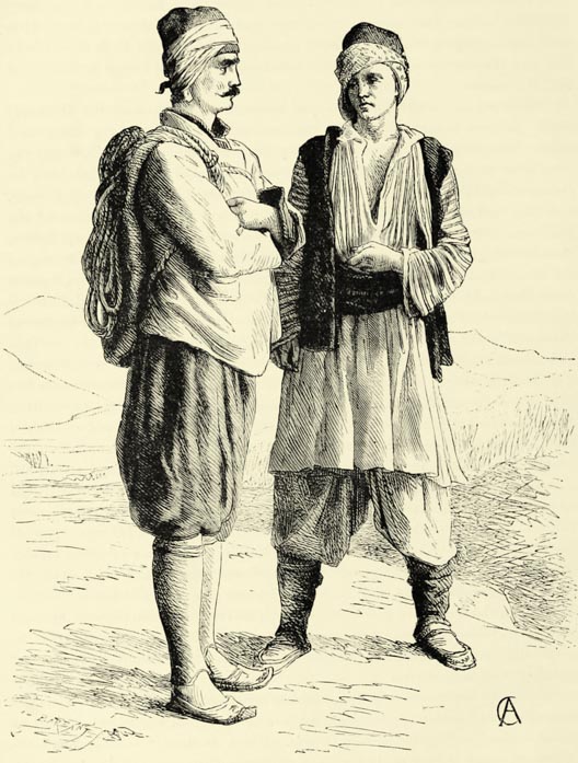
Phœnician merchants and Roman conquerors scarcely modified the elements composing the population of Hellas, but during the age of migrations barbarians in large numbers penetrated into Greece. For more than two centuries did the Avares maintain themselves in the Peloponnesus. Then came the Slavs, aided, on more than one occasion, by the plague in depopulating the country. Greece became a Slavonia, and a Slavonian language, probably Servian, was universally spoken, as is proved by the majority of geographical names. The superstitions and legends {42} of the modern Greeks, as has been remarked by many authors, are not simply a heritage derived from the ancient Hellenes, but have become enriched by phantoms and vampires of Slav invention. The dress of the Greeks, too, is a legacy of their northern conquerors. But, in spite of this, the polished language of the Hellenes {43} has regained by degrees its ancient preponderance, and the race has so thoroughly amalgamated these foreign immigrants, that it is impossible now to trace any Servian elements in the population. But hardly had Hellas escaped the danger of becoming Slav when it was threatened with becoming Albanian. This occurred during the dominion of Venice. As recently as the commencement of the present century Albanian was the dominant language of Elis, Argos, Bœotia, and Attica, and even at the present day a hundred thousand supposed Hellenes still speak it. The actual population of Greece is, therefore, a very mixed one, but it is difficult to say in what proportions these Hellenic, Slav, and Albanian elements have combined. The Mainotes, or Maniotes, of the peninsula terminating in Cape Matapan, are generally supposed to be the Greeks of the purest blood. They themselves claim to be the descendants of the ancient Spartans, and amongst their strongholds they still point out one which belonged to “Signor Lycurgus.” Their Councils of Elders have preserved from immemorial times, and down to the war of independence, the title of Senate of Lacedæmonia. Every Mainote professes to love unto death “Liberty, the highest of all goods, inherited from our Spartan ancestors.” Nevertheless, a good many localities in Maina bear names derived from the Servian, and these prove, at all events, that the Slavs resided in the country for a considerable time. The Mainotes practise the vendetta, as if they were Montenegrins. But is not this a common custom amongst all uncivilised nations?
However this may be, in spite of invasions and intermixture with other races, the Greeks of to-day agree in most points with the Greeks of the past. Above all things, they have preserved their language, and it is truly matter for surprise that the vulgar Greek, though derived from a rural dialect, should differ so slightly only from the literary language. The differences, analogous to what may be observed with respect to the languages derived from the Latin, are restricted almost to two points, viz. the contraction of non-accentuated syllables and the use of auxiliary verbs. It was, therefore, easy for the modern Greeks to purify their language from barbarisms and foreign terms, and to restore it gradually to what it was in the time of Thucydides. Nor has the race changed much in its physical features, for in most districts of modern Greece the ancient types may yet be recognised. The Bœotian is still distinguished by that heavy gait which made him an object of ridicule amongst the other Greeks; the Athenian youth possesses the suppleness, grace of movement and bearing which we admire so much in the horsemen sculptured on the friezes of the Parthenon; the Spartan women have preserved that haughty and vigorous beauty which constituted the charm of the virgins of Doris. As regards morals, the descent of the modern Hellenes is equally evident. Like their ancestors, they are fond of change, and inquisitive; as the descendants of free citizens, they have preserved a feeling of equality; and, still infatuated with dialectics, they hold forth at all times as if they were in the ancient market-place, or Agora. They frequently stoop to flattery: like the ancient Greeks, too, they are apt to rate intellectual merit above purity of morals. {44} Like sage Ulysses of the Homeric poem, they well know how to lie and cheat with grace; and the truthful Acarnanian and the Mainote, who are “slow to promise, but sure to keep,” are looked upon as rural oddities. Another trait in the character of the modern and ancient Greeks, and one which distinguishes them from all other Europeans, is this—that they do not allow themselves to be carried away by passion, except in the cause of patriotism. The Greek is a stranger to melancholy: he loves life, and is determined to enjoy it. In battle he may throw it away, but suicide is a species of death unknown amongst the modern Greeks, and the more unhappy they are, the more they cling to existence. They are very seldom afflicted with insanity.
Μ
Fig. 10.—FOREIGN ELEMENTS IN THE POPULATION OF GREECE.
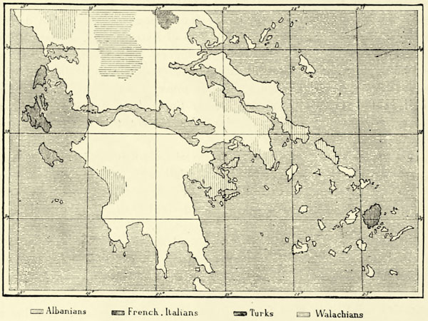
In spite of the diverse elements which compose it, the Greek nationality is one of the most homogeneous in Europe. The Albanians, of Pelasgian descent like the Greeks, do not cede to the latter in patriotism; and it was they—the Suliotes, Hydriotes, Spezziotes—who fought most valiantly for national independence. The eight hundred families of Rumanian or Kutzo-Wallachian Zinzares who pasture their herds in the hills of Acarnania and Ætolia, and are known as Kara-Gunis, or “black cloaks,” speak the two languages, and sometimes marry Greek girls, though they never give their own daughters in marriage to the Greeks. Haughty and free, they are not sufficiently numerous to be of any great importance. To foreigners the Greeks are rather intolerant, and they take no pains to render their stay amongst them agreeable. The Turks—who were numerous formerly in certain parts of the Peloponnesus, in Bœotia, and in the {45} island of Eubœa, and whose presence recalled an unhappy period of servitude—have fled to a man, and only the fez, the narghile, and the slippers remind us of their former presence. The Jews, though met with in every town of the East, whether Slav or Mussulman, dare hardly enter the presence of the Greeks, who are, moreover, their most redoubtable rivals in matters of finance: they are to be found only in the Ionian Islands, where they managed to get a footing during the British Protectorate. In this same Archipelago we likewise meet with the descendants of the ancient Venetian colonists, and with emigrants from all parts of Italy. French and Italian families still form a distinct element of the population of Naxos, Santorin, and Syra. As to the Maltese porters and gardeners at Athens and Corfu, they continue for the most part in subordinate positions, and never associate with the Greeks.
The homogeneous character of the population of Greece does not admit of that country being divided into ethnological provinces, like Turkey or Austro-Hungary, but it consists geographically of four distinct portions. These are (1), continental Hellas, known since the Turkish invasion as Rumelia, in remembrance of the “Roman” empire of Byzantium; (2), the ancient Peloponnesus, now called the Morea, perhaps a transposition of the word “Romea,” or from a Slav word signifying “sea coast,” and applied formerly to Elis; (3), the islands of the Ægean Sea; (4), the Ionian Islands. In describing the various portions of Greece we shall make use, in preference, of the ancient names of mountains, rivers, and towns; for the Hellenes of our own day, proud of the glories of the past, are endeavouring gradually to get rid of names of Slav or Italian origin, which still figure upon the maps of their country.13
II.—CONTINENTAL GREECE.
The Pindus, which forms the central chain of Southern Turkey, passes over into Greece, and imparts to it an analogous orographical character. On both sides of this conventional boundary we meet with the same rocks, the same vegetation, the same landscape features, and the same races of people. By dividing the Epirus and handing over Thessaly to the Turks, European diplomacy has paid no attention to natural features. The eastern portion of the boundary is made to follow the line of water parting over the range of the lofty Othrys, commanding the plain of the Sperchius. Westward of the Pindus the boundary {46} crosses transversely the valley of the Achelous, and the hills which separate it from the Gulf of Arta.
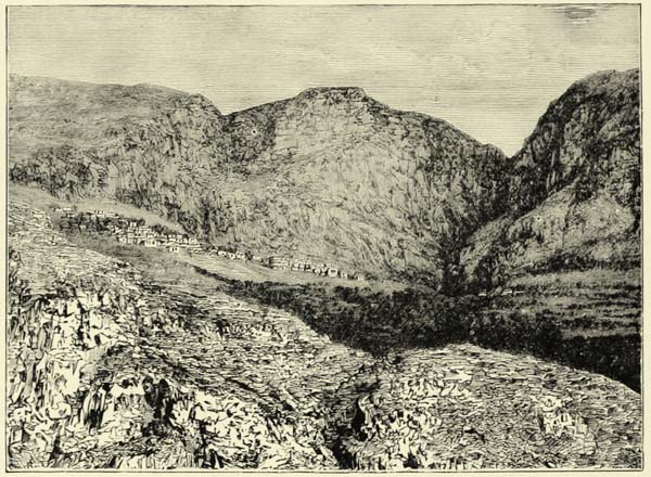
Fig. 11.—MOUNT PARNASSUS AND DELPHI.
The isolated summit of Mount Tymphrestus, or Velukhi, which rises where the grand chain of the Othrys branches off from the Pindus, is not the culminating point of continental Greece, but it is a centre from which the principal mountain spurs and rivers radiate. Within its spurs lies hidden the charming valley of Karpenisi, and an elevated ridge joins them, towards the south-east, to the most important mountain mass of modern Greece, viz. the group surmounted by the snow-clad pyramids of the Vardusia and Khiona, whose slopes are covered with dark firs, and to the superb Katavothra, the Œta of the ancients, on which Hercules built his funeral pile. The mountains of Vardusia and Khiona are face to face with the fine mountain masses of Northern Morea, likewise wooded and covered with snow during the greater part of the year.
The mountains of Ætolia, to the west of the Velukhi and the Vardusia, are far less elevated, but they are rugged, and form a veritable chaos of rocks, savage defiles, and thickets, into which only Wallachian herdsmen venture. In Southern Ætolia, on the shores of the lakes and along the rivers, the country is more accessible, but mountains rise there likewise, and by tortuous ridges they are brought into connection with the system of the Pindus. Those on the coast of Acarnania, opposite to the Ionian Islands, are steep, covered with trees and shrubs; they are the mountains of the “Black Continent” mentioned by Ulysses. {47} To the east of the Achelous there is another coast chain, well known to mariners: this is the Zygos, the southern slopes of which, arid and austere, are seen from off Missolonghi. Still further to the east another range comes down to the seashore, and, together with the promontories on the opposite coast of the Morea, forms the narrow entrance to the Gulf of Corinth. Close to this entrance, on the Ætolian side, there rises bold Mount Varassova, a huge block of rock. Local tradition tells us that the Titans endeavoured to throw this rock into the sea, so that it might form a bridge between the two coasts; but the rock proved too heavy, and it was dropped where we now see it.
Towards the Ægean Sea the mountain mass of the Katavothra is continued by a coast range running in a direction parallel to the mountains of the island of Eubœa. This range should be described rather as a series of mountain-groups separated from each other by deep hollows, extensive depressions, and even by river valleys. These mountains, though low and intersected by numerous roads, are nevertheless difficult of access, for their slopes are steep, their promontories abrupt, and their precipices sudden, and in the times of the ancient Greeks a small number of men repeatedly defended them against large armies. At one extremity of this range is the passage of Thermopylæ; at the other, on the eastern foot of the Pentelicus, the famous plain of Marathon.
The mountain groups on the northern shore of the Gulf of Corinth, and to the south of Bœotia, may be looked upon as a range running parallel with that following the channel of Eubœa, but far more beautiful and picturesque. Every one of its summits recalls the sweet memories of poetry, or conjures up the image of some ancient deity. To the west we find ourselves in the presence of “double-headed” Parnassus, to which fled Deucalion and Pyrrha, the ancestors of the Greeks, and where the Athenians celebrated their torchlight dances in honour of Bacchus. From the summits of the Parnassus, which rival in height those of the Khiona, raising its pyramidal head towards the north-west, nearly the whole of Greece, with its gulfs, islands, and mountains, lies spread out below us, from the Thessalian Olympus to the Taygetus, at the extremity of the Peloponnesus; and close by, at our feet, lies the admirable basin of Delphi, the place of Peace and Concord, where Greeks forgot their animosities. The mountain group towards the east next to Parnassus is quite equal to it. The valleys of the Helicon, the seat of Apollo and the Muses, are still the most verdant and the most smiling in all Greece. The eastern slope of the Helicon is more especially distinguished for its charming beauty, its woods, its verdant pastures, gardens, and murmuring springs, which contrast most favourably with the bare and arid plains of Bœotia. If Mount Parnassus may boast of the Castalian spring, Mount Helicon possesses that of Hippocrene, which burst forth from the ground when struck by the hoof of Pegasus. The elongated summit of the Cithæron, the birthplace of Bacchus, joins the mountains of Southern Bœotia to those of Attica, whose marble has become famous through the neighbourhood of the city which they shelter. Mount Parnes rises to the north of Athens; to the east of it, like the pediment of a temple, rises the Pentelicus, in which are {48} the quarries of Pikermi, rendered famous through their fossil bones; on the south appears Mount Hymettus, celebrated for its flowers and its bees. Farther away, the Laurium, with its rich argentiferous slags, stretches towards the south-east, and terminates in Cape Sunium, consecrated in other days to Minerva and Neptune, and still surmounted by fifteen columns of an ancient temple.
Another isolated mountain group to the south of Attica, and occupying the entire width of the Isthmus of Megara, served the Athenians as a rampart of defence against their neighbours of the Peloponnesus. This is the mountain group of Gerania, the modern Pera Khora.14 Having passed beyond it, we find ourselves upon the Isthmus of Corinth, properly so called, confined between the Gulfs of Athens and of Corinth. It is a narrow neck of land, scarcely five miles across, whose arid limestone rocks hardly rise two hundred feet above the sea. This neutral bit of territory, lying between two distinct geographical regions, naturally became a place for meetings, festivals, and markets. The remains of a wall built by the Peloponnesians across the isthmus may still be traced, as may also the canal commenced by order of Nero.
The limestone mountains of Greece, as well as those of the Epirus and of Thessaly, abound in lakes, but all the rivers are swallowed up in “sinks,” or katavothras, leaving the land dry and arid. Southern Acarnania, a portion of which is known as Xeromeros, or the “arid country,” on account of the absence of running water, abounds in lake basins of this kind. To the south of the Gulf of Arta, which may not inaptly be described as a sort of lake communicating with the sea through a narrow opening, there are several sheets of water, the remains of an inland sea, silted up by the alluvial deposits of the Achelous. The largest of these lakes is known to the natives as Pelagos, or “big sea,” because of its extent and the agitated state of its waters, which break against its coasts. This is the Trichonius of the ancient Ætolians. Reputed unfathomable, it is, in truth, very deep, and its waters are perfectly pure; but they are discharged sluggishly into another basin far less extensive, and surrounded by pestilential marshes, and through a turgid stream they even find their way into the Achelous. The hills surrounding Lake Trichonis are covered with villages and fields, whilst the locality around the lower lake has been depopulated by fever. The country, nevertheless, is exceedingly beautiful to look upon. Hardly have we passed through a narrow gorge, or klisura, of Mount Zygos before we enter upon a bridge over a mile in length, which a Turkish governor caused to be thrown across the swamps separating the two lakes. This viaduct has sunk down more than half its {49} height into the mud, but it is still sufficiently elevated to enable the eye freely to sweep over the surface of the waters, and to trace the coasts which bound them. Oaks, planes, and wild olive-trees intermingle beneath us, their branches hung with festoons of wild vine, and these, with the blue waters of the lake and the mountains rising beyond it, form a picture of great beauty.
Μ
Fig. 12.—LOWER ACARNANIA.
Scale 1 : 800,000.
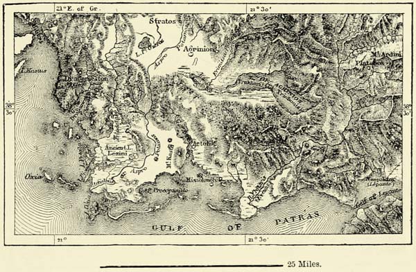
Another lake basin lies to the south of the Zygos, between the alluvial lands of the Achelous and the Fidari. It is occupied by a swamp filled with fresh, brackish, or salt water; and since the days of ancient Greece, this swamp, owing to the apathy of the inhabitants, has continued to increase in extent at the expense of the cultivated land. Missolonghi the heroic is indebted for its name to its position near these marshes, for the meaning of it is “centre of marshes.” A barrier, or ramma, here and there broken through by the floods, separates the basin of Missolonghi from the Ionian Sea. During the war of independence every opening in this barrier was protected by redoubts or stockades, but at present the only obstruction consists of the reed barriers of the fishermen, which are opened in spring to admit the fish from the sea, and closed in summer to prevent their escape. Missolonghi, though surrounded by brackish water, is a healthy place, thanks to the breezes from the sea; whilst a heavy atmosphere charged with miasmata hangs perpetually over the bustling little town of Ætoliko (Anatolikon), which lies farther to the north-west in the midst of the swamps, and is joined to the dry land by two bridges. Between Ætoliko and the river Achelous may be observed a large number of rocky eminences, rising like pyramids above the plain. These are no doubt ancient islands, such as still exist between the mainland and the island of St. Mauro. The mud brought down by the Achelous has gradually converted the intervals between these {50} rocks into dry land. In former times the commercial city of Œniadæ occupied one of these islets. The geological changes already noticed by Herodotus are thus still going on under our eyes, and the muds of the Achelous, to which it owes its modern name of Aspro, or “white,” incessantly extend the land at the expense of the sea.
Μ
Fig. 13.—THERMOPYLÆ.
From the French Staff Map (1852). Scale 1 : 330,000.
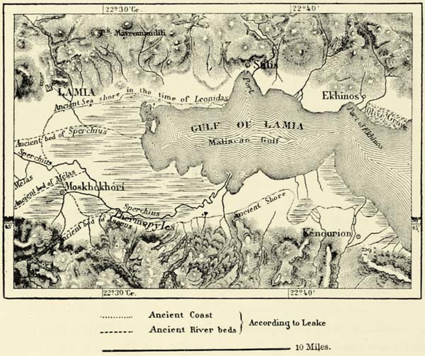
The Achelous, which the ancients likened to a savage bull, owing to its rapid current and great volume, is by far the most important river of Greece. One of the great feats ascribed to Hercules consisted in breaking off one of the horns of this bull; that is to say, he embanked the river, and thus protected the lands which it used to inundate. The neighbours of the Achelous, the rapid Fidari (Evenus, on the banks of which Hercules killed the centaur Nessus, for offering violence to Dejanira) and the Mornos, which rises in the snows of the Œta, cannot compare with it. Still less is it equalled by the Oropus, the Cephissus, and the Ilissus, “wet only when it rains,” which flow eastward into the Ægean Sea. The principal river of Eastern Greece, the Sperchius, is inferior to the Achelous, but, like it, has extensively changed the aspect of the plain near its mouth. When Leonidas and his three hundred heroes guarded the defiles of Thermopylæ against the Persians, the Gulf of Lamia extended much farther into the land than it does now. But the alluvial deposits of the river have extended its delta, and several rivulets which formerly flowed {51} directly into the sea have now to be numbered amongst its tributaries; the sea has retired from the foot of the Callidromus for a distance of several miles; and the narrow pass of Thermopylæ has been converted into a plain sufficiently wide to enable an entire army to manœuvre upon it. The hot springs which gush from the rocks, by forming deposits of calcareous tufa, may likewise have contributed towards this change of coast-line; nor are more violent convulsions of nature precluded in a volcanic region like this, subject to frequent earthquakes. Sailors still point out a small island in this neighbourhood, formed of scoriæ, from which the incensed Hercules hurled his companion, Lichas, into the ocean. Hot springs abound on the opposite coast of Eubœa, and the incrustations formed by them are so considerable as to assume the appearance of glaciers when seen from a distance. A bathing establishment exists now near the hot sulphur springs of Thermopylæ, and strangers are thus enabled to explore this region, so rich in memories of a great past. The pedestal, however, upon which reposed the figure of a marble lion, placed there in honour of Leonidas, has been destroyed by ruthless hands, and utilised in the construction of a mill !
The basin of the Cephissus, enclosed by the chains of the Œta and Parnassus, is one of the most remarkable from an hydrological point of view. The river first flows through a bottom-land formerly a lake, and then, forcing for itself a passage through a narrow defile commanded by the spurs of Mount Parnassus, it winds round the rock upon which stood the ancient city of Orchomenus, and enters upon a vast plain, where swamps and lakes are embedded amidst cultivated fields and reed-banks. These swamps are fed, likewise, by numerous torrents descending from the Helicon and other mountains in its vicinity. One of these is the torrent of Livadia, into which the bounteous springs of Memory and Oblivion—Mnemosyne and Lethe—discharge themselves. In summer a large portion of the plain is dry, and it yields a bountiful harvest of maize, the stalks of which are sweet like sugar-cane. But after the heavy rains of autumn and winter the waters rise twenty, and even twenty-five feet, and the plain is converted into a vast lake, ninety-six square miles in extent. The myth of the deluge of Ogyges almost leads us to believe that the rising floods occasionally invaded every valley which debouches into this basin. To the ancients the shallower part of this lake was known as Cephissus, and its deep eastern portion as Copais, from Copæ, a town occupying a promontory on its northern shore, and now called Topolias.
Μ
Fig. 14.—LAKE COPAIS
From the French Staff Map. Scale 1 : 500,000.
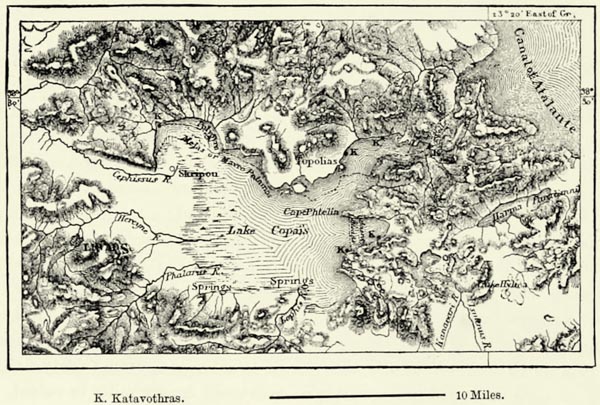
The importance of regulating the floods just referred to, and of preventing the sudden overflow of the waters to the destruction of the cultivated fields, may readily be imagined. The ancient Greeks made an effort to accomplish this task. To the east of the large Lake of Copais there is another lake basin, about one hundred and thirty feet lower, and encompassed by precipitous rocks, incapable of cultivation. This basin, the Hylice of the Bœotians, appears to be made by nature for receiving the superabundant waters of the Copais. The remains of a canal may still be traced in the plain, which was evidently intended to convey into {52} it the floods of the Copais, but it appears never to have been completed. No doubt care was taken to keep open the various katavothras, or subterranean channels, through which the waters of the Copaic lake discharge themselves into the sea. One of these, on the north-western shore of the lake, and close to the rock of Orchomenus, swallowed up the river Melas, and conveyed its waters to the Gulf of Atalanta. Farther to the east other subterranean channels flow towards Lakes Hylice and Paralimni, but the most important of these channels are towards the north-east, in the Gulf of Kokkino. In that extreme angle of the lake, the veritable Copais, the waters of the Cephissus rush against the foot of Mount Skroponeri, and are swallowed up by the ground so as to form a subterranean delta. To the south there is a cavernous opening in the rock, but this is merely a sort of tunnel passing underneath a promontory, and, except during the rainy season, it may be traversed dry-shod. Beyond this, another opening swallows up one of the most important branches of the Cephissus, which makes its reappearance in the shape of bounteous springs pouring their waters into the sea. Two other branches of the river disappear in the rocks about a mile farther north. They join soon afterwards, and flow northwards beneath the bottom of a sinuous valley. The old Greek engineers dug pits in this valley, which enabled them to descend to the subterranean waters, and to clear away obstructions interfering with their flow. Sixteen of these pits have been discovered between the opening of the katavothra and the place where the waters reappear. Some of these are still thirty to one hundred feet in depth; but most of them have become choked up with stones and earth. These ancient engineering works, which Crates vainly endeavoured to restore in the time of Alexander, may possibly date {53} from the mythical age of King Minyas of Orchomenus,15 and the successful draining of these marshes may account for the well-filled treasury of that king spoken of by Homer. Thus the ingenuity of the Homeric age had succeeded in accomplishing a work of the engineering art which baffles our modern men of science !
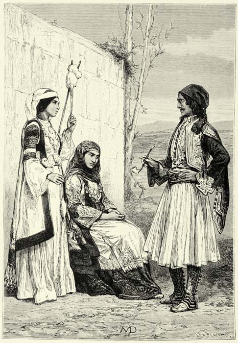
PEASANTS FROM THE ENVIRONS OF ATHENS.
The whole of Western Greece, filled as it is by the mountains of Acarnania, Ætolia, and Phocis, is condemned by nature to play a very subordinate part to the eastern provinces. In the time of the ancient Greeks these provinces were looked upon almost as a portion of the world of the barbarians, and even in our own days the Ætolians are the least cultivated of all the Greeks. There is no commerce except at a few privileged places close to the sea, such as Missolonghi, Ætoliko, Salona, and Galaxidi. The latter, which is situated on a bay, into which flows the Pleistus, a river at one time consecrated to Neptune, although quite dry during the greater part of the year, was, up to the war of independence, the busiest seaport on the Gulf of Corinth. As for Naupactus, or Epakto, (called Lepanto by the Italians), it was important merely from a strategical point of view, on account of its position at the entrance of the Gulf of Corinth, which is sometimes named after it. Many naval engagements were fought to force the entrance into the gulf, defended by the castles of Rumelia and Morea—the ancient Rhium and Antirrhium. A curious phenomenon has been observed in connection with the channel which forms the entrance to the Gulf of Corinth. Nowhere more than 36 fathoms in depth, it is subject to perpetual changes in its width, owing to the formation of alluvial deposits by maritime currents. What one current deposits is carried away by the other. At the epoch of the Peloponnesian war this channel was 7 stadia, or about 1,200 yards, wide; at the time of Strabo its width was only 5 stadia; whilst in our own days it is no less than 2,200 yards from promontory to promontory. The entrance of the Gulf of Arta, between the Turkish Epirus and Greek Acarnania, does not present the same phenomena, and its present width is about equal to that assigned to it by every ancient author; that is to say, about 1,000 yards.
The valleys and lake basins of Eastern Greece, and more especially its position between the Gulf of Corinth, the Ægean Sea, and the channel of Eubœa, which almost convert it into a peninsula, sufficiently account for the prosperity of that country. With its cities of Thebes, Athens, and Megara, it is essentially a land of historical reminiscences. The contrast between the two most important districts of this region—Bœotia and Attica—is very striking. The first of these is an inland basin, the waters of which are collected into lakes, where mists accumulate, and a rich vegetation springs forth from a fat alluvial soil. Attica, on the other hand, is arid. A thin layer of mould covers the terraces of its rocky slopes; its valleys open out into the sea; the summits of its mountains rise into an azure sky; and the blue waters of the Ægean wash their base. Had the Greeks been fearful of the sea; had they confined themselves, as in the earliest {54} ages, to the cultivation of the soil, Bœotia, no doubt, would have retained the preponderance which it enjoyed in the time of the Minyæ of wealthy Orchomenus. But the progress of navigation and the allurements of commerce, which proved irresistible to the Greeks, were bound by degrees to transfer the lead to the men of Attica. The city of Athens, which arose in the midst of the largest plain of this peninsula, therefore occupied a position which assured to it a grand future.
Fig. 15.—THE ACROPOLIS OF ATHENS.
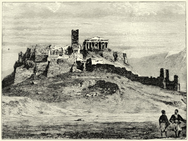
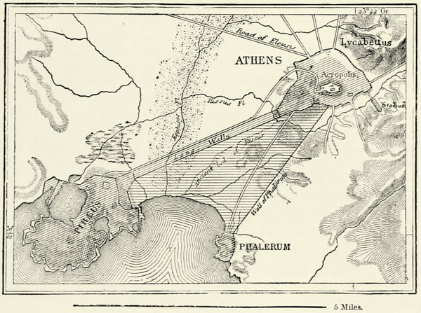
The choice of Athens as the modern capital of Greece has been much criticized. Times have changed, no doubt, and the natural centres of commerce have become shifted, in consequence of the migrations of nations. Corinth, on the isthmus joining continental Greece to the Peloponnesus, and commanding two seas, undoubtedly deserved the preference. Its facilities for communicating with Constantinople and the Greek maritime districts still under the rule of the Osmanli, on the one hand, and with the western world, from which now proceed all civilising impulses, on the other, are certainly greater than those of Athens. If Greece, instead of a small centralised kingdom, had become a federal republic, which would have been more in accordance with her genius and traditions, there is no doubt that other towns of Greece, more favourably situated than Athens for establishing rapid communications with the rest of Europe, would soon have surpassed that town in population and commercial wealth. Athens, however, has grown upon its plain, and, by the construction of a railway, it has become even {55} a maritime city, as in ancient days, when its triple walls joined it to the ports of the Piræus and Phalerum.
Μ
Fig. 16.—ATHENS AND ITS LONG WALLS.
According to Kiepert and Schmidt. Scale 1 : 114,000.
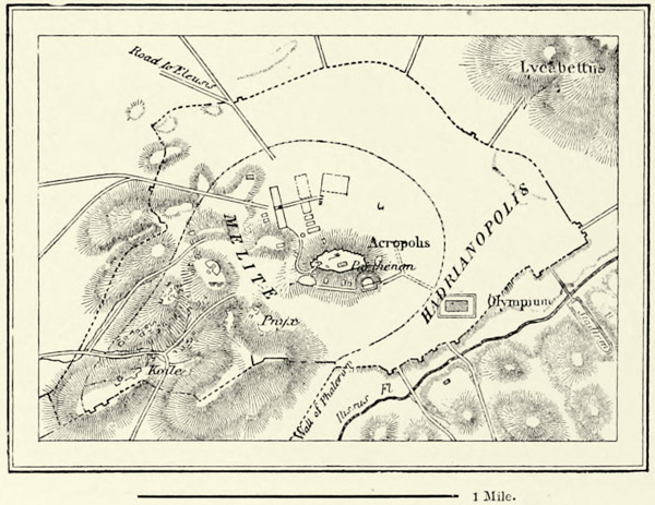
But how great the difference between the monuments of the ancient city and of the modern ! The Parthenon, though gutted by the shells of the Venetian Morosini, and robbed since of its finest sculptures, still retains its pure and simple beauty, which agrees so well with the sobriety of the surrounding landscape—still remains the finest architectural work of the world. By the side of this majestic ruin, on the same plateau of the Acropolis, where the mariner in the Gulf of Ægina saw the gilt spear-head of Athene Promachos glitter in the sun, there rise other monuments, the Erechtheum and the Propylæa, hardly inferior to it, and dating likewise from the great period of art. Outside the city, on a promontory, rises the temple of Theseus, the best-preserved monument of Greek antiquity. Elsewhere, on the banks of the Ilissus, a group of columns marks the site of the magnificent temple of Olympian Jupiter, which it took the Athenians seven hundred years to build, and which their degenerate descendants made use of as a quarry. Remarkable remains have been discovered in many other parts of the ancient city, and the least of them are of interest, for they recall the memory of illustrious men. On such a rock sat the Areopagus which condemned Socrates; from this stone tribune Demosthenes addressed the multitude; and here walked Plato with his disciples !
A similar historical interest attaches to nearly every part of Attica, whether we visit the city of Eleusis, where the mysteries of Ceres were celebrated, or the {56} city of Megara, with its double Acropolis, or whether we explore the field of Marathon and the shores of the island of Salamis. Even beyond Attica the memories of the past attract the traveller to Platæa, to Leuctra, Chæronea, Thebes of Œdipus, and Orchomenus of Minyas, though, in comparison with what these districts were in other times, they are now deserts. In addition to Athens and Thebes, there are now only two cities in eastern continental Greece which are of any importance. These are Lamia, in the midst of the low plains of the Sperchius, and Livadia, in Bœotia, at one time celebrated for the cavern of Trophonius, which archæologists have not yet succeeded in identifying. The island of Ægina, which belongs to Attica, offers the same spectacle of decay and depopulation as the mainland. Anciently it supported more than two hundred thousand inhabitants; at present it hardly numbers six thousand. But the island still retains the picturesque ruin of its temple of Minerva, and the prospect which it affords of the amphitheatre of hills in Argolis and Attica is as magnificent as ever.
Μ
Fig. 17.—ANCIENT ATHENS.
According to Kiepert and Schmidt. Scale 1 : 30,000.
III.—THE MOREA, OR PELOPONNESUS.
Geographically the Peloponnesus well deserves the name of island, which was bestowed upon it by the ancients. The low Isthmus of Corinth completely severs it from the mountainous peninsula of Greece. It is a world in itself, small enough as far as the mere space is concerned which it occupies upon the map, but great on account of the part it has played in the history of humanity. {57}
On entering the Peloponnesus from the Isthmus of Corinth, we see rising in front of us the mountain rampart of Oneium, which defended the entrance of the peninsula, and upon one of whose promontories was built the nearly impregnable citadel of Corinth. These mountains form part of the general mountain system of the whole island, and, sheltered by them, its inhabitants could live in security. The principal mountain mass, whence all other chains radiate towards the entrances of the peninsula, is situated in the interior of the country, about forty miles to the west of Corinth. There Mount Cyllene of the ancient Greeks, or Zyria, rises into the air, its flanks covered with dark pines; and farther away still, the Khelmos, or Aroanian Mountain, attains even a more considerable height, its snows descending into a valley on its northern slope, where they give rise to the river Styx, the cold waters of which prove fatal to perjurers, and disappear in a narrow chasm, one of the entrances to Hades. A range of wooded peaks, to the west of the Khelmos, connects that mountain with the Olonos (Mount Erymanthus), celebrated as the haunt of the savage boar destroyed by Hercules. All those mountains, from Corinth as far as Patras, form a rampart running parallel with the southern shore of the gulf, in the direction of which they throw off spurs enclosing steep valleys. In one of these—that of Buraikos—we meet with the grand caverns of Mega-Spileon, which are used as a monastery, and where the most curious structures may be seen built up on every vantage-ground offered by the rocks, suggesting a resemblance to the cells of a vast nest of hornets.
The table-land of the Peloponnesus is thus bounded towards the north by an elevated coast range. Another chain of the same kind bounds it on the east. It likewise starts from Mount Cyllene, and extends southward, its various portions being known as Gaurias, Malevo (Mount Artemisium), and Parthenion. It is then broken through by a vast depression, but again rises farther south as the range of Hagios Petros, or Parnon, to the east of Sparta. Getting lower by degrees, it terminates in the promontory of Malea, opposite to the island of Cerigo. It was this cape, tradition tells us, which formed the last refuge of the Centaurs; that is to say, of the barbarian ancestors of the modern Tsakonians. No promontory was more dreaded by Greek navigators than this Cape Malea, owing to sudden gusts of wind, and an ancient proverb says, “When thou hast doubled the cape forget the name of thy native land.”
The mountains of Western Morea do not present the regularity of the eastern chain. They are cut through by rivers, and to the south of the Aroanian Mountains and the Erymanthus they ramify into a multitude of minor chains, which now and then combine into mountain groups, and impart the most varied aspect to that portion of the plateau. Everywhere in the valleys we come unexpectedly upon landscapes to which an indescribable charm is imparted by a group of trees, a spring, a flock of sheep, or a shepherd sitting upon a heap of ruins. We are in beautiful Arcadia, sung by the poets. Though in great part deprived of its woods, it is still a beautiful country; but more charming still are the eastern slopes of the plateau, which descend towards the Ionian Sea. There luxuriant forests and {58} sparkling rivulets add an element of beauty to blue waves, distant islands, and a transparent sky, which is wanting in nearly every other part of maritime Greece.
Fig. 18.—MOUNT TAYGETUS.
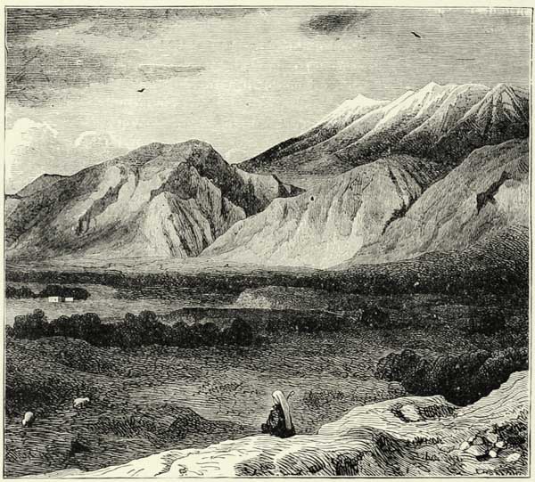
The table-land of Arcadia is commanded on the west by pine-clad Mænalus, and bounded on the south by several mountain groups which give birth to separate mountain chains. One of these mountain masses—the Kotylion, or Palæocastro—thus gives rise to the mountains of Messenia, amongst which rises the famous Ithome, and to those of Ægaleus, which spread over the peninsula to the west of the Gulf of Coron, and reappear in the sea as the rocky islets of Sapienza, Cabrera, and Venetikon. Another mountain mass, the Lycæus, or Diaforti—the Arcadian Olympus, which the Pelasgians claim for their cradle—and which rises almost in the centre of the Peloponnesus, is continued westward of Laconia by an extended mountain chain, the most elevated and most characteristic of all the Morea. The highest crest of these mountains is the famous Taygetus, known also as Pentedactylum (five fingers), because of the five peaks which surmount it; or as St. Elias, in honour, no doubt, of Helios, the Dorian sun-god. A portion of the lower slopes of this mountain is clothed with forests of chestnuts and walnuts. {59} interspersed with cypresses and oaks; but its crest is bare, and snow remains upon it during three-fourths of the year. The snows of Taygetus direct the distant mariner to the shores of Greece. On approaching the coast, he sees rising above the blue waters the spurs and outlying ridges of the Kakavuni, or “bad mountain.” Soon afterwards he comes in sight of the promontory of Tainaron, with its two capes of Matapan and Grasso—immense blocks of white marble more than six hundred feet in height, upon which the quails settle in millions after their fatiguing journey across the sea. Into the caverns at its foot the waters rush with a dull noise which the ancients mistook for the barking of Cerberus. Cape Matapan, like Malea, is dreaded amongst mariners as a great “destroyer of men.”
The three southern extremities of the Peloponnesus are thus occupied by high mountains and rocky declivities. The peninsula of Argolis, in the east, is likewise traversed by mountain ranges, which start from Mount Cyllene, similarly to the Gaurias and the mountains of Arcadia. The whole of the Peloponnesus is thus a country of table-lands and mountain ranges. If we except the plains of Elis, which have been formed by the alluvial deposits carried down by the rivers of Arcadia, and the lake basins of the interior, which have been filled up in the course of ages, we meet with nothing but mountains.16 The principal mountain masses—the Cyllene, the Taygetus, and Parnon—are composed of crystalline schists and metamorphic marbles, as in continental Greece. Strata of the Jurassic age and beds of cretaceous limestone are here and there met with at the foot of these more ancient rocks. Near the coast, in Argolis, and on the flanks of the Taygetus, eruptions of serpentines and porphyries have taken place, whilst on the north-eastern coast of Argolis, and especially on the small peninsula of Methone, there exist recent volcanoes—amongst others, the Kaimenipetra, which M. Fouqué identifies with the fire-vomiting mouths of Strabo, and which had its last eruption twenty-one centuries ago. These volcanoes are, no doubt, the vents of a submarine area of disturbance which extends through Milos, Santorin, and Nisyros, to the south of the Ægean Sea.
The sulphur springs which abound on the western coast of the Peloponnesus are, perhaps, likewise evidences of a reaction of the interior of the earth.
It is the opinion of several geologists that the coasts of Western Greece are being insensibly upheaved. In many places, and particularly at Corinth, we meet with ancient caverns and sea beaches at an elevation of several feet above the sea-level. It is this upheaval, and not merely the alluvial deposits brought down by rivers, which explains the encroachment of the land upon the sea at the mouth of the Achelous and on the coast of Elis, where four rocky islets have been joined to the land. Elsewhere a subsidence of the land has been noticed, as in the Gulf of {60} Marathonisi and on the eastern coast of Greece, where the ancient peninsula of Elaphonisi has been converted into an island. But even there the fluvial deposits have encroached upon the sea. The city of Calamata is twice as distant from the seashore now as in the days of Strabo, and the traces of the ancient haven of Helos, on the coast of Laconia, are now far inland.
The limestone rocks of the interior of the Peloponnesus abound as much in chasms, which swallow up the rivers, as do Bœotia and the western portion of the whole of the Balkan peninsula. Some of these katavothras are mere sieves, hidden beneath herbage and pebbles, but others are wide chasms and caverns, through which the course of the underground waters may be readily traced. In winter wild birds post themselves at the entrances of these caverns, in expectation of the prey which the river is certain to carry towards them; in summer, after the waters have retired, foxes and jackals again take possession of their accustomed dens. The water swallowed up by these chasms on the plateau reappears on the other side of the mountains in the shape of springs, or kephalaria (kephalovrysis). The water of these springs has been purified by its passage through the earth, and its temperature is that of the soil. It bursts forth sometimes from a crevice in the rocks, sometimes in an alluvial plain, and sometimes even from the bottom of the sea. The subterranean geography of Greece is not yet sufficiently known to enable us to trace each of these kephalaria to the katavothras which feed them.
Μ
Fig. 19.—LAKES PHENEA AND STYMPHALUS.
From the French Staff Map. Scale 1 : 500,000.
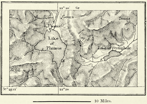
The ancients were most careful in keeping open these natural funnels, for, by facilitating the passage of the water, they prevented the formation of swamps. These precautions, however, were neglected during the centuries of barbarism which overcame Greece, and the waters were permitted to accumulate in many places at the expense of the salubrity of the country. The plain of Pheneus, or Phonia, a vast chasm between the Aroanian Mountains and the Cyllene, has thus repeatedly been converted into a lake. In the middle of last century the whole of this basin {61} was filled with water to a depth of more than 300 feet. In 1828, when this sheet of water had already become considerably reduced, it was still 6 miles long and 150 feet in depth. At length, a few years afterwards, the subterranean sluices opened, the waters disappeared, and there remained only two small marshes near the places of exit. But in 1850 the lake was again 200 feet in depth. Hercules, we are told, constructed a canal to drain this valley and to cleanse its subterranean outlets, but the inhabitants content themselves now with placing a grating above the “sink-holes,” to prevent the admission of trunks of trees and of other large objects carried along by the floods.
To the east of the valley of Pheneus, and on the southern foot of Mount Cyllene, there is another lake basin, celebrated in antiquity because of the man-eating birds which infested it, until they were exterminated by Hercules. This is the Stymphalus, alternately lake and cultivated land. During winter the waters cover about one-third of the basin; but it happens occasionally, after heavy rains, that the lake resumes its ancient dimensions. There is only one katavothra through which the waters can escape, and this, instead of being near the shore, as usual, is at the bottom of the lake. It swallows up not only the water of the lake, but likewise the vegetable remains carried into it, and the mud formed at its bottom; and this detritus is conveyed through it to some subterranean cavity, where it putrefies slowly, as may be judged from the fetid exhalations proceeding from the katavothra. The water, however, is purified, and when it reappears on the surface, close to the seashore, it is as clear as crystal.
There are many other lake basins of the same kind between the mountains of Arcadia and the chain of the Gaurias. They all have their swamps or temporary lakes, but the katavothras, in every instance, are sufficiently numerous to prevent an inundation of the entire valley. The most important of these lake basins is formed by the famous plain of Mantinea, upon which many a battle was fought. From an hydrological point of view this is one of the most curious places in the world; for the waters which collect there are discharged into two opposite seas—the Gulf of Nauplia on the east, and in the direction of the Alpheus and the Ionian Sea towards the west. There may exist even some subterranean rivulet which discharges itself, towards the south, into the Eurotas and the Gulf of Laconia.
The disappearance of the waters underground has condemned to sterility several parts of the Peloponnesus, which a little water would convert into the most fertile regions of the globe. The surface waters quickly suck up and form subterranean rivers, hidden from sight, which only see the light again, in most instances, near the seashore, when it is impossible to utilise them. The plain of Argos, though surrounded by a majestic amphitheatre of well-watered hills, is more sterile and arid even than are Megara and Attica. Its soil is always dry, and soaks up water like a sieve, which may have given rise to the fable of the Danaids. But to the south of that plain, where there is but a narrow cultivable strip of land between the mountains and the seashore, a great river bursts forth from the rocks. This is the Erasinus.
Other springs burst forth at the southern extremity of the plain, close to the defile {62} of Lerna, which, like that of the Erasinus, are supposed to be fed from Lake Stymphalus. Close to them is a chasm filled with water, said to be unfathomable. It abounds in tortoises, and venomous serpents inhabit the adjoining marsh. These are the kephalaria, or “heads,” of the ancient hydra of Lerna, which Hercules found it so difficult to seize hold of. Still farther south there is another spring which rises from the bottom of the sea, more than three hundred yards from the shore. This spring—the Doinæ of the ancients, and Anavula of modern Greek mariners—is, in reality, but the mouth of one of the rivers swallowed up by the katavothras of Mantinea. When the sea is still it throws up a jet rising to a height of fifty feet.
Μ
Fig. 20.—THE PLATEAU OF MANTINEA.
From the French Staff Map. Scale 1 : 400,000.
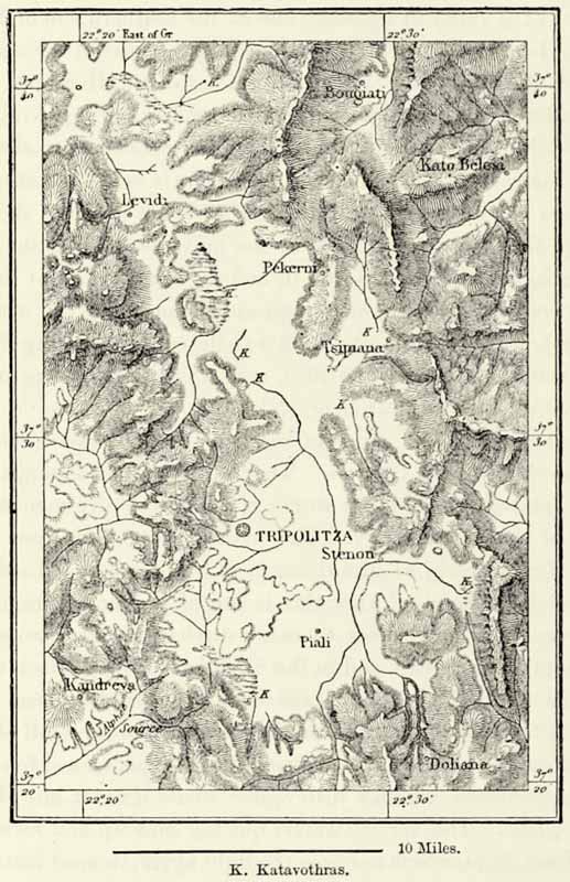
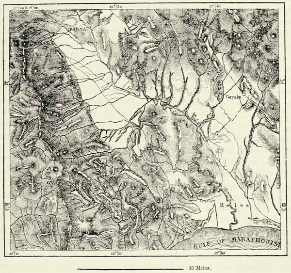
Analogous phenomena may be witnessed in the two southern valleys of the peninsula, those of Sparta and Messenia. The Iri, or Eurotas, is, in reality, but a large rivulet, which discharges itself into the Gulf of Marathonisi, at the end of a gorge, {63} through which the waters of the Lake of Sparta forced themselves a passage during some ancient deluge; but it is only on rare occasions that its volume of water is sufficient to remove the bar which obstructs its mouth. The Vasili-Potamo (“royal river”), on the other hand, which bursts forth at the foot of a rock a short distance from the Eurotas, though its whole course does not exceed five miles, discharges a considerable volume of water throughout the year, and its mouth is at all times open. As to the river of Messenia, the ancient Pamisus, now called Pirnatza, it is the only river of Greece, besides the Alpheus, which forms a harbour at its mouth, and it can be ascended by small vessels for a distance of eight miles; but this advantage it owes exclusively to the powerful springs of Hagios Floros, which are fed by the mountains on the east. These springs, which form a large swamp where they rise to the surface, are the real river, if volume of water is to be decisive, and the country watered and fertilised by them was called the “Happy” by the ancients, on account of its fertility.
Μ
Fig. 21.—BIFURCATION OF THE GASTUNI.
From the French Staff Map. Scale 1 : 400,000.
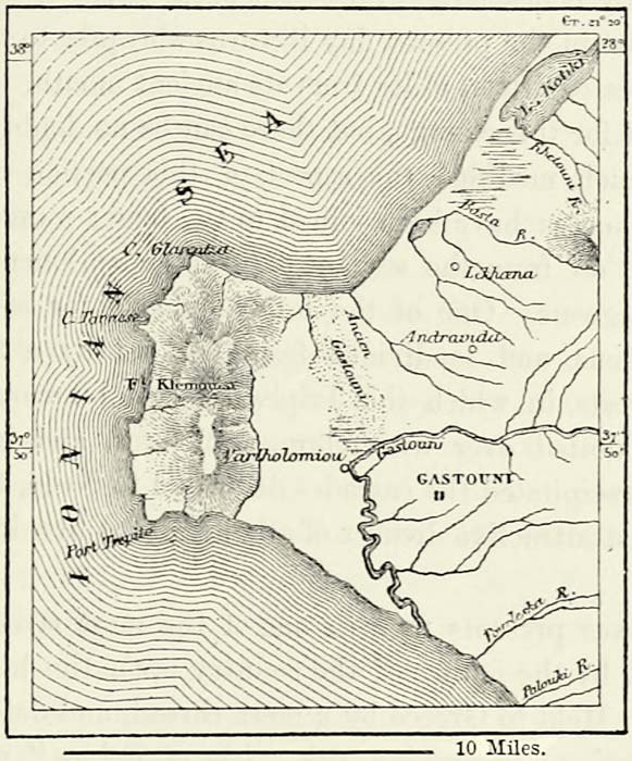
The western regions of the Peloponnesus receive more rain, and they are likewise in the possession of the most considerable river, the Alpheus, now called Ruphia, from one of its tributaries. The latter, the ancient Ladon, conveys a larger volume of water towards the sea than the Alpheus. It was as celebrated amongst the Greeks as was the Peneus of Thessaly, on account of the transparency of its waters, and the smiling scenery along its banks. It is partly fed by the snows of Mount Erymanthus, and, like most rivers of the Morea, derives a portion of its waters from subterranean tributaries rising on the central plateau. The Ladon thus receives the waters of Lake Phenea, whilst the Alpheus proper {64} is fed in its upper course from katavothras on the shores of the ancient lakes of Orchomenus and Mantinea. Having traversed the basin of Megalopolis, anciently a lake, it passes through a series of picturesque gorges, and reaches its lower valley. A charming tradition, illustrative of the ties of amity which existed between Elis and Syracuse, makes this river plunge beneath the sea and reappear in Sicily, close to the fountain of his beloved Arethusa. The ancient Greeks, who witnessed the disappearance of so many rivers, would hardly have looked upon this submarine course of the Alpheus as a thing to wonder at.
The Alpheus and all other rivers of Elis carry down towards the sea immense masses of detritus, which they spread over the plains extending from the foot of the mountains to the seashore. The ruins of Olympia disappeared in this manner beneath alluvial deposits. They have all frequently changed their beds, and not one amongst them has done so more frequently than the Peneus, or river of Gastuni. Anciently it discharged its waters to the north of the rocky promontory of Chelonatas, whilst in the present day it turns abruptly to the south, and enters the sea at a distance of fifteen miles from its ancient mouth. Works of irrigation may partly account for this change, but there can be no doubt that nature unaided has by degrees much modified the aspect of this portion of Greece. Islands originally far in the sea have been joined to the land; numerous open bays have gradually been cut off from the sea by natural embankments, and transformed into swamps or lagoons. One of the latter extends for several leagues to the south of the Alpheus, and is divided from the sea by a fine forest of pines. These majestic forests, in which the Triphylians paid honour to their dead, the surrounding hills dotted over with clumps of trees, and Mount Lycæus, from whose flanks are precipitated the cascades dedicated to Neda, the nurse of Jupiter, render this the most attractive district of all the Morea to a lover of nature.
The Peloponnesus presents us with one of the most striking instances of the influence exercised by the nature of the country upon the historical development of its inhabitants. Held to Greece by a mere thread, and defended at its entrance by a double bulwark of mountains, this “isle of Pelops” naturally became the seat of independent tribes at a time when armies still recoiled from natural obstacles. The isthmus was open as a commercial high-road, but it was closed against invaders.
The relief of the peninsula satisfactorily explains the distribution of the tribes inhabiting it, and the part they played in history. The whole of the interior basin, which has no visible outlets towards the sea, naturally became the home of a tribe who, like the Arcadians, held no intercourse with their neighbours, and hardly any amongst themselves. Corinth, Sicyon, and Achaia occupied the seashore on the northern slopes of the mountains, but were separated by high transversal chains. The inhabitants of these isolated valleys long remained strangers to each other, and when at length they combined to resist the invader, it was too late. Elis, in the west, with its wide valleys and its insalubrious plains extending along a coast having no havens, naturally played but a secondary part {65} in the history of the peninsula. Its inhabitants, exposed to invasions, owing to their country being without natural defences, would soon have been enslaved, had they not placed themselves under the protection of all the rest of Greece by converting their plain of Olympia into a place of meeting, where the Hellenes of Europe and of Asia, from the continent and from the islands, met for a few days’ festival to forget their rivalries and animosities. The basin of Argos and the mountain peninsula of Argolis, on the eastern side of the Peloponnesus, on the other hand, are districts having natural boundaries, and are easily defended. Hence the Argolians were able to maintain their autonomy for centuries, and even in the Homeric age they exercised a sort of hegemony over the remainder of Greece. The Spartans were their successors. The country in which they established themselves possessed the double advantage of being secure against every attack, and of furnishing all they stood in need of. Having firmly established themselves in the beautiful valley of the Eurotas, they found no difficulty in extending their power to the seashore, and to the unfortunate Helos. At a later date they crossed the heights of the Taygetus, and descended into the plains of Messenia. That portion of Greece likewise formed a natural basin, protected by elevated mountain ramparts; and the Messenians, who were kinsmen of the Spartans and their equals in bravery, were thus able to resist for a century. At length they fell, and all the Southern Peloponnesus acknowledged the supremacy of Sparta, which was now in a position to assert its authority over the whole of Greece. Then it was that the mountain-girt plateau on the road from Lacedæmonia to Corinth, upon which stood the cities of Tegea and Mantinea, and which was made by nature for a field of Mars, became the scene of strife.
The Peloponnesus, with its sinuous shores, forms a remarkable contrast to Attica. Its characteristics are essentially those of a continent, and anciently the Peloponnesians were mountaineers rather than mariners. Except in Corinth, where the two seas nearly join, and a few towns of Argolis, which is another Attica, there were no inducements for the inhabitants to engage in maritime commerce; and in their mountain valleys and upland plains they were entirely dependent upon the rearing of cattle and husbandry. Arcadia, in the centre of the peninsula, was inhabited only by herdsmen and labourers; and its name, which originally meant “country of bears,” has become the general designation for an eminently pastoral country. The Laconians also, separated from the sea by rocky mountains which hem in the valley of the Eurotas at its point of issue, preserved for a long time the customs of warriors and of cultivators of the soil, and took to the sea only with reluctance. “When the Spartans placed Eurotas and Taygetus at the head of their heroes,” says Edgar Quinet, “they distinctly connected the features of the valley with the destinies of the people by whom it was occupied.”
In the very earliest ages the Phœnicians already occupied important factories on the coasts of the Peloponnesus. They had established themselves at Nauplia, in the Gulf of Argos; and at Cranaæ, the modern Marathonisi or Gythion, in Laconia, they purchased the shells which they required to dye their purple {66} cloths. The Greeks themselves were in possession of a few busy ports, amongst which was “sandy Pylos,” the capital of Nestor, whose position is now held by Navarino, on the other side of the gulf. At a subsequent date, when Greece had become the centre of Mediterranean commerce, Corinth, so favourably situated between the two seas, rose into importance, not because of its political influence, its cultivation of the arts, or love of liberty, but through the number and wealth of its inhabitants. It is said that it had a population of three hundred thousand souls within its walls. Even after it had been razed by the Romans it again recovered its ancient pre-eminence. But the exposed position of the town has caused it to be ravaged so many times that all commerce has fled from it. In 1858, when an earthquake destroyed Corinth, that once famous city had dwindled down into a poor village. The city has been rebuilt about five miles from its ancient site, on the shore of the gulf named after it, but we doubt whether it will ever resume its ancient importance unless a canal be dug to connect the two seas. The high-roads from Marseilles and Trieste to Smyrna and Constantinople would then lead across the Isthmus of Corinth, and this canal might attract an amount of shipping equal to that which frequents other ocean channels or canals similarly situated. But for the present the isthmus is almost deserted, and only the passengers who are conveyed by Greek steamers to the small ports on its opposite shores cross it. The ancients, who had failed in the construction of a canal, and who made no further effort after the time of Nero, because they imagined one of the two seas to be at a higher level than the other, had provided, at all events, a kind of tramway, by means of which their small vessels could be conveyed from the Gulf of Corinth to the Ægean Sea.17
After the Crusades, when the powerful Republic of Venice had gained a footing upon the coasts of Morea, flourishing commercial colonies arose along them, in Arcadia, on the island of Prodano (Prote), at Navarino, Modon, Coron, Calamata, Malvoisie, and Nauplia in Argolis. At the call of these Venetian merchants the Peloponnesus again became a seat of trade, and resumed, to some extent, that part in maritime enterprise which it had enjoyed in the time of the Phœnicians. But the advent of the Turk, the impoverishment of the soil, and the civil wars which resulted therefrom, again forced the inhabitants to break off all intercourse with the outer world, and to shut themselves up in their island as in a prison. Tripolis, or Tripolitza, in the very centre of the peninsula, and called thus, it is said, because it is the representative of three ancient cities—Mantinea, Tegea, and Pallantium—then became the most populous place. Since the Greeks have regained their independence life again fluctuates towards the seashore as by a sort of natural sequence. Patras, close to the entrance of the Gulf of Corinth, and near the most fertile and best-cultivated plains on the eastern shore, is by far the most important city at present, and, in anticipation of its future extension, the streets of a new town have been laid out, in the firm belief that it will some day rival Smyrna and Trieste in extent. {67}
Μ
Fig. 22.—THE VALLEY OF THE EUROTAS.
From the French Staff Map. Scale 1 : 370,000.
The other towns of the peninsula, even those which exhibited the greatest activity during the dominion of the Venetians, are but of very secondary importance, if we compare them with this emporium of the Peloponnesus. Ægium, or Vostitza, on the Gulf of Corinth, is a poor port, less celebrated on account of its commerce than in consequence of a magnificent plane-tree, more than fifty feet in girth, the hollow trunk of which was formerly used as a prison. Pyrgos, close to the Alpheus, has no port at all. The fine roadstead of Navarino, defended against winds and waves by the rocky islet of Sphacteria, is but little frequented, and the merchantmen riding at anchor there never outnumber the Turkish men-of-war at the bottom, where they have lain since the battle fought in 1828. Modon and Coron have likewise fallen off. Calamata, at the mouth of the fertile valleys of Messenia, has an open roadstead only, and vessels cannot always ride in safety upon it. The celebrated Malvoisie, now called Monemvasia, is hardly more than a heap of ruins, and the vineyards in its neighbourhood, which furnished the exquisite wine named after the town, have long ceased to exist. Nauplia, which was the capital of the modern kingdom of Greece during the first few years of its existence, possesses the advantage of a {68} well-sheltered port; but its walls, its bastions, and its forts give it the character of a military town rather than of a commercial one.
The towns in the interior of the country, whatever glories may attach to them, are hardly more now than large villages. The most celebrated of all, Sparta, thanks to the fertility of its environs, promises to become one of the most prosperous cities of the interior of the Peloponnesus. Sparta—that is, the “scattered city,”—was named thus because its houses were scattered over the plain, defended only by the valour of their inhabitants, and not by walls. In the Middle Ages Sparta was supplanted by the neighbouring Mistra, whose decayed Gothic buildings and castles occupy a steep hill on the western side of the Eurotas; but it has now recovered its supremacy amongst the towns of Laconia. Argos, which is more ancient even than the city of Lacedæmon, has likewise risen anew from its ruins; for the plain in which it lies, though occasionally dried up, is of great natural fertility.
Strangers, however, who explore the countries of the Peloponnesus, do not go in search of these newly risen cities, where a few stones only remind them of the glories of the past, but are attracted by the ancient monuments of art. In that respect Argolis is one of the richest provinces of Greece. Near to Argos the seats of an amphitheatre are cut into the steep flanks of the hill of Larissa. Between Argos and Nauplia a small rock rises in the middle of the plain, which is surmounted by the ancient Acropolis of Tiryns, the Cyclopean walls of which are more than fifty feet in thickness. A few miles to the north of Argos are the ruins of Mycenæ, the city of Agamemnon, where the celebrated “Gate of Lions,” coarsely sculptured when Greek art first dawned, and the vast vaults known as the Treasury of the Atrides, mainly attract the attention of visitors. These vaults are amongst the oldest and best-preserved antiquities of Greece. They exhibit most solid workmanship, and one of the stones, which does duty as a lintel over the entrance-gate, weighs no less than one hundred and sixty-nine tons. At Epidaurus, in Argolis, on the shores of the Gulf of Ægina, and close to the most famous temple of Æsculapius, we still meet with a theatre which has suffered less from time than any other throughout Greece. Shrubs, interspersed with small trees, surround it; but we can still trace its fifty-four rows of white marble seats, capable of affording accommodation to twelve thousand spectators. Amongst other famous ruins of Argolis are the beautiful remains of a temple of Jupiter at Nemea, and the seven Doric columns of Corinth, said to be the oldest in all Greece. But the most beautiful edifice of the peninsula must be sought for near Arcadian Phigalia, in the charming valley of the Neda. This is the temple of Bassæ, erected by Ictinus in honour of Apollo Epicurius, and its beauty is enhanced by the oaks and rocks which surround it.
Citadels, however, are the buildings we most frequently meet with; and many a fortified place, with its walls and acropolis, yet exists as in the days of ancient Greece. The walls of Phigalia and Messenia still have their ancient towers, gates, and redoubts. Other fortifications were utilised by the Crusaders, Venetians, or Turks, and by them furnished with crenellated walls and keeps, which add another picturesque feature to the landscape. One of these ancient {69} fortresses, transformed during the Middle Ages, rises at the very gates of the Peloponnesus—namely, the citadel of Corinth, the strongest and most commanding of all.
Several of the islands of the Ægean Sea must be looked upon as natural dependencies of the Peloponnesus, to which submarine ledges or shoals attach them.
The islands along the coast of Argolis, which are inhabited by Albanian seamen, who were amongst the foremost to fight the Turk during the struggle for Hellenic independence, have lost much of their former commercial importance. Poros, a small Albanian town on a volcanic island of the same name, which the revolted people chose for their capital, is, however, still a bustling place, for it has an excellent harbour, and the Greek Government has made it the principal naval station of the kingdom. Hydra, on the other hand, and the small island of Spezzia, next to it, have lost their former importance. They are both rocky islands, without arable soil, trees, or water, and yet they formerly supported a population of fifty thousand souls. About 1730 a colony of Albanians, weary of the exactions of some Turkish pasha on the mainland, fled to the island of Hydra. They were left in peace there, for they agreed to pay a trifling tribute. Their commerce—leavened, to be sure, with a little piracy—assumed large dimensions, and immediately before the war of independence the Albanians of Hydra owned nearly 400 vessels of 100 to 200 tons each, and they were able to send over 200 vessels, armed with 200 guns, against the Turks. By engaging so enthusiastically in this struggle for liberty, the Hydriotes, without suspecting it, wrought their own ruin. No sooner was the cause of Greece triumphant than the commerce of Hydra was transferred to Syra and the Piræus, which are more favourably situated.
Cythera of Laconia, a far larger island than either of those mentioned, and better known by the Italian name of Cerigo, formed a member of the Septinsular Republic, although not situated in the Ionian Sea, and clearly a dependency of the Peloponnesus. Cythera is no longer the island of Venus, and its voluptuous groves have disappeared. Seen from the north, it resembles a pile of sterile rocks. It nevertheless yields abundant harvests, possesses fine plantations of olive-trees, and populous villages. Cerigo, in former times, enjoyed considerable importance, owing to its position between the Ionian Sea and the Archipelago; but Cape Malea has lost its terrors now, and the harbour of refuge on the island is no longer sought after. Heaps of shells, left there by Phœnician manufacturers of purple, have been found on the island; and it was the Phœnicians who introduced the worship of Venus Astarte.
IV.—THE ISLANDS OF THE ÆGEAN SEA.
Islands and islets are scattered in seeming disorder over the Ægean Sea, the name of which may probably mean “sea of goats,” because these islands appeared at a distance like goats. By a singular misapplication the modern term {70} Archipelago, instead of sea, is now used to designate these groups of islands. The Sporades, in the north, form a long range of islands stretching in the direction of Mount Athos. The island of Scyros, farther south, the birthplace of Achilles and place of exile of King Theseus, occupies an isolated position; the large island of Eubœa extends along the coast of the continent; and in the distance rise the white mountains of the Cyclades, likened by the ancient Greeks to a circle of Oceanides dancing around a deity.
Μ
Fig. 23.—EURIPUS AND CHALCIS.
Scale 1 : 220,000.
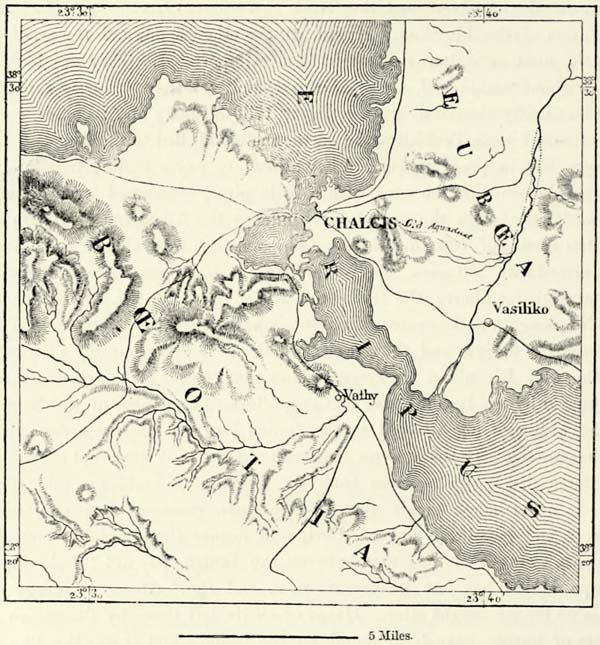
All these islands are so many fragments of the mainland. This is proved by their geological structure, or by shoals which attach them to the nearest coast. The Northern Sporades are a branch of Mount Pelion. Eubœa is traversed by limestone mountains of considerable height, running parallel to the chains of Attica, Argolis, Mount Olympus, and Mount Athos. Scyros is a rocky mountain mass, whose axis runs in the same direction as that of the central chain of Eubœa. The summits of the Cyclades continue the ranges of Eubœa and Attica towards the south-east, and the same micaceous and argillaceous schists, limestones, and crystalline marbles are found in them. They are, indeed, “mountains of Greece {71} scattered over the sea.” If Athens may boast of the quarries of Mount Pentelicus, the Cyclades produce the glittering marbles of Naxos, and the still more beautiful ones of Paros, from which were chiselled the statues of heroes and of gods. Curious caverns are met with in the limestone of the islands, especially that of Antiparos, the existence of which was not known to the ancients, and the Cave of Sillaka, on the island of Cythnos, or Thermia, celebrated for its hot springs. Granite is found on some of the islands, and particularly in the small island of Delos, dedicated to the worship of Apollo and Diana. In the south, finally, the Cyclades are traversed by a chain of volcanic islands, extending from the peninsula of Methana, in Argolis, to Cos and the shores of Asia Minor.
Eubœa may be looked upon almost as a portion of the continent, for the strait which separates it from the mainland resembles a submerged longitudinal valley, and is nowhere of great depth or width. At its narrowest part it is no more than two hundred and fourteen feet across, and from the most remote times, Chalcis, the capital of the island, has been joined to the mainland by a bridge. The irregular tidal currents flowing through this strait were looked upon as marvellous by the Greeks, and Aristotle is said to have flung himself into it because he was unable to explain this phenomenon. The Italian name of the island, Negroponte, is formed by a series of corruptions from Euripus, by which name the ancients knew the strait between the island and the mainland. Eubœa has at all times shared in the vicissitudes of the neighbouring provinces of Attica and Bœotia. When the cities of Greece were at the height of their glory, those of Eubœa—Chalcis, Eretria, and Cerinthus—enjoyed likewise a high degree of prosperity, and dispatched colonies to all parts of the Mediterranean. Later on, when invaders ravaged Attica, Eubœa shared the same fate, and at present it participates in every political and social movement of the neighbouring continent.
In Northern Eubœa there are forests of oaks, pines, elms, and plane-trees; the villages are embedded in orchards; and the surrounding country resembles what we have seen in Elis and Arcadia. But in the Cyclades we look in vain for charming landscapes. Foliage and running water abound only in a very few spots. Arid rocks, more arid even than those on the coast of Greece, predominate, and only in a few favoured spots do we meet with a few olive-trees, valonia oaks, pines, and fig-trees. Everywhere else the hills are naked. And yet these islands arouse feelings of devotion in us, for their names are great in history. The highest summits of most of them have been named after the prophet Elias, the biblical successor of Apollo, the god of the sun; and justly so, for the sun reigns supreme upon these austere rocks, and his scorching rays destroy every vestige of vegetation.
Antimilos, one of the uninhabited islands of this group, still affords an asylum to the wild goat (Capra Caucasica), which has disappeared from the remainder of Europe, and is met with only in Crete, and perhaps Rhodes. Wild pigs likewise haunt the rocks of Antimilos. Rabbits were introduced from the West, and abound in the caverns of some of the Cyclades, and especially on Myconus and Delos. The ancient authors never mention these animals. It is a curious fact that {72} hares and rabbits never inhabit the same island, with the sole exception of Andros, where the hares occupy the extreme north, whilst the rabbits have their burrows in the southern portion of the island. As a curiosity, we may also mention that a large species of lizard, called crocodile by the inhabitants, is found on the islands, but not on the neighbouring continent, and we may conclude from this that the Cyclades were separated from the Balkan peninsula at a very remote period.
A chain of volcanic islands bounds the Cyclades towards the south, where they are separated from Crete by an ocean trough of great depth. Milos is the most important of these islands. It has an irregularly shaped crater, which has been invaded by the sea, and forms there one of the safest and most capacious harbours of refuge in the Mediterranean. Milos has had no eruption within historic times, but the existence of solfataras and of hot springs proves that its volcanic forces are not yet quite extinct.
Μ
Fig. 24.—NEA KAMMENI.
According to Danfalik.
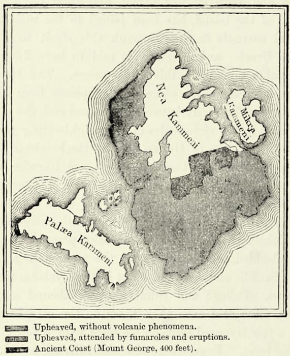
The actual centre of volcanic activity has to be looked for in a small group of islands known as Santorin, and lying midway between Europe and Asia. These islands consist of marbles and schists, similar to those of the other Cyclades, and they surround a vast crater no less than twelve hundred and eighty feet in depth. The crescent-shaped island of Thera, on the east, presents bold cliffs towards the crater, while its gentle outer slopes are covered with vineyards producing exquisite wine. Therasia, on the west, rises like an immense wall; and the islet of {73} Aspronisi, between the two, indicates the existence of a submarine partition wall which separates the crater from the open sea. The submarine volcano occupies the centre of this basin. It remains quiescent for long periods, and then suddenly arousing itself, it ejects immense masses of scoriæ. Nearly twenty-one centuries ago the first island rose to the surface in the centre of this basin. This island is known now as Palæa Kammeni, or the “old volcano.” Three years of eruptions in the sixteenth century gave birth to the smallest of the three islands, Mikra Kammeni. A third cone of lava, Nea Kammeni, rose in the eighteenth century; and quite recently, between 1866 and 1870, this new island has more than doubled its size, overwhelming the small village of Volkario and its port, and extending to within a very short distance of Mikra Kammeni. No less than half a million of partial eruptions occurred during those five years, and the ashes were sometimes thrown to a height of four thousand feet. Even from Crete clouds of ashes could be seen suspended in the air, black during the day, and lit up by night.
Thousands of spectators hastened to Santorin from all quarters of the world to witness these eruptions, and amongst them were several men of science—Fouqué, Gorceix, Reiss, Stübel, and Schmidt—whose observations have proved of great service. The crater of Santorin appears to have been produced by a violent explosion which shattered the centre of the ancient island, and covered its slopes with enormous masses of tufa.18
Southern Eubœa and the vicinity of Port Gavrion, on the island of Andros, are inhabited by Albanians, but the population in the remainder of the Archipelago is Greek. The families of Italian or French descent on Scyros, Syra, Naxos, and Santorin are not sufficiently numerous to constitute an element of importance. They claim to be of French descent, and are known in the Archipelago as Franks, and during the war of independence they claimed the protection of the French Government. In former times nearly the whole of the land was held by these Franks, who had taken possession of it during the Middle Ages, and these large estates are made to account for the sparse population of Naxos, which supported a hundred thousand inhabitants formerly, but is now hardly able to support one-seventh that number.
The Cyclades are farther removed from the coast of Greece than Eubœa, and they have not always shared in the historical dramas enacted upon the neighbouring continent. Their position in the centre of the Archipelago naturally caused them to be visited by all the nations navigating the Mediterranean, and their inhabitants were thus subjected to the most diverse influences. In ancient times the mariners of Asia Minor and of Phœnicia called at the Cyclades on their voyages to Greece; during the Middle Ages the Byzantines, the Crusaders, the Venetians, the Genoese, the Knights of Rhodes, and the Osmanli were masters {74} there in turn; and in our own days the nations of Western Europe, with the Greeks themselves, hold the preponderance in the Archipelago.