Volume 1 — CHAPTER VIII.
Reading edition
WESTERN SUDAN.
KORDOFAN AND DARFUR.
Section I.—Kordofan.
1. General Description.
The country between the Nile and the eastern frontier of Darfur consists of vast plains broken in places by clusters of hills, which rarely exceed 600 feet in height above the plain. In the north, these plains are intersected by wadis which run down from the hills and gradually lose themselves in the sand. The country is thinly covered with low scrub, which becomes denser in the wadis. Towards the south the khors gradually become less and less, until about lat. 14° 30′ north they cease. Here the real bush country commences, and the surface of the ground becomes more undulating. There is no visible watershed, the rain sinking in where it falls.
The northern plains, occupied by camel-owning tribes, consist chiefly of reddish sand, which, if the rains are good, supports plenty of coarse grass and crops of dukhn. Should they fail, even the grass in the wadis does not afford grazing, and the wells give out (1902-03).
In the undulating country between El Obeid and the river the grey gum acacia (hashab) is the prevailing tree. The soil here contains more clay than further north. Between Id El Ud and Zereiga on the east, and Hashaba and Jebel Kon on the west, is a waterless district called El Agaba, in which grows little but marakh bush and coarse grass.
Between El Agaba and the river the ground falls, at first abruptly, and then very gently, to the river. The sandy soil gradually disappears, and along the bank is replaced by a strip of black soil, in places, 12 miles wide. This soil is rich and is generally overgrown with thick bush. On the river bank, and as far inland as the floods at high Nile reach, large red sunt trees are found. At high Nile these often stand in 3 or 4 feet of water. During the rains this soil becomes a swamp, impassable for camels in most places, the khors fill with water, and the roads near the river go out of use. As soon as the rains stop and the river falls, this soil dries up and cracks, and until the paths have been used for some time the going is very bad.
Dar Hamid.In Dar Hamid, a large district north-west of Bara, there is a series of basins running from north to south, divided by steep ridges of red sand. At the bottom of each basin, locally called a “khor,” the soil is white, sandy earth, containing much lime. Water is here found at a depth of from 4 to 10 feet. These khors were formerly all cultivated by Danagla, who used shadufs or saglias. The whole district, which extends from Ashaf in the south to Shershar in the north, is known as El Kheiran. Date, dom, and deleib palms, as well as limes grow, and in a few places gardens with onions, shatta (red pepper), rigl, etc., have been made.
Southern portion.Though the change is very gradual, south of lat. 13° 15′ the plains become more level. They are broken by deep khors with steep banks, and are covered with thick bush or tall trees up to the foot of the Nuba hills. Further south the bush becomes larger, until huge forest trees are met with. On the edge of the khors there are immense creepers and tangled undergrowth. The soil appears fertile, but is only cultivated near the hills. The rest of the country is covered with jungle, and becomes a swamp in the rains, but afterwards quickly dries up. The timber found is of little value, being chiefly acacia. Game is abundant. Elephant, giraffe, and antelope abound; monkeys and birds are found in great numbers in the woods. Snakes are also said to be common.
Dar Nuba.Dar Nuba is the only part of Kordofan where the scenery can be said to be pretty, and some of the views of the hills looking over masses of forest are really beautiful, whereas most of the rest of the country is wearisome from its sameness. The hills in the north are nearly bare of vegetation. On all the Nuba hills thorny bushes grow between the rocks, except on a few of the more isolated hills, whose summits consist of piled masses of rock devoid of vegetation. They are terraced for cultivation, by the people, to a height of 300 or 400 feet from their base.
Hills.The most important groups of hills are, in the north, Jebel Haraza and Jebel Kaja Katul, both inhabited by Nuba Arabs, and Jebel Kaja Serrug in the west. In the south, Jebel Daier, Jebel Tagale, Jebel Kadero, Jebel Gedir, Jebel Moro, Jebel Talodi, Jebel Kari, Jebel Eliri-liri, and Jebel El Joghub, are all inhabited by Nubas.
Dar Hamar.Dar Hamar, the country west of Dar Hamid, and extending up to the Darfur frontier, consists of gently undulating steppes covered with bush. In places there are a few low rocky hills, and the horizon is broken by huge tebeldi trees. As there are few wells, almost the whole population depends on the water that is stored in these trees during the rains. Throughout the province, from November until June, the plains have a dried-up appearance, only broken by the few trees, such as the hashab and marakh, that remain green throughout the year, and in the southern districts by the trees in the khors, which can be traced as bands of dark green, winding through the black hills and dull brown plains.
Drainage system.The drainage system of Kordofan is complicated. It is doubtful if any rain that falls there ever reaches the Nile, unless it does so underground. In the north, the hard sand forms wide shallow wadis, which, after wandering for a greater or lesser distance, either lose themselves by spreading over a bare surface, or by striking an outcrop of rock form a “sink,” which enables shallow wells to be dug, and gives an excellent supply of water. In the south, the softer soil and more abundant rainfall, together with, in places, steeper gradients, cause the shallow wadis of the north to be replaced by narrow khors with steep sides. But the water eventually disappears from the surface in the same way as in the northern districts. For example, the wadi from Abu Tabr and those north of Jebel Derish end at Shageig, where a plentiful supply of water is to be found all the year round. Jebel Kajmar also is the natural dam to Wadi El Sigai, which flows from the south. Habisa is another similar place. In the south, the Khor Abu Habl loses itself west of Gedid, and further west, El Sinut, a large lake in the rains, and a swamp afterwards, is believed to have no outlet.
KORDOFAN ARABS WITH CHIEF.
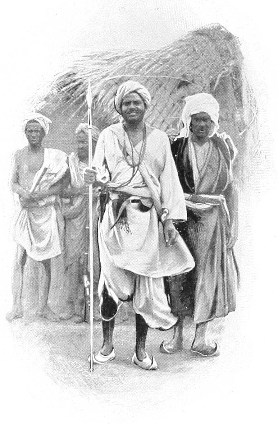
Lakes.The chief lakes are Abu Serai, Sherkeila, El Rahad, and El Birka. In January, 1900, all were dry, but in 1901, El Rahad lasted for the whole year, though El Birka was dry by the end of December. Abu Serai always dries up a few weeks after the rains cease. Sherkeila is said generally to dry up, but was full in December, 1900, and was expected to last until the next rains. Rahad was also full.
These lakes are said to be all connected with the Khor Abu Habl, but native information points to El Rahad being the end of Khor Khashgil, only Sherkeila and Abu Serai joining the Khor Abu Habl. As a proof of this, in 1902, after the rains, Sherkeila was full and El Rahad nearly empty. When dry, wells are dug in the bottom of the lakes.
In Western Kordofan there is a series of swamps—Abu Zabbat, El Sinut, El Seneita, Toto, Kutna, and Burdia—but though in the rains they are generally full of water, they dry up almost at once, and can hardly be dignified with the name of lakes. The Baggara Arabs, who frequent these swamps, dig wells in the middle of them as they dry up and build up the mouths with wood and earth to a height of 4 or 5 feet, to prevent the mud and grass washing in during the rains. In Southern Kordofan there are many such tracts of land under water during the rains; and Butler Bey (in March, 1902) found, about 50 miles north-west of Jebel Eliri, a lake called El Abiad, which although said never to dry up, was dry in January, 1903. It was (in March, 1902) about 6 miles by 4 miles, and contained excellent fish. As far as could be ascertained it had no outlet. The only really permanent lake, as far as is known, is Lake Keilak in the Dar Homr district, which is about 4½ miles by 2 miles.
Wadis, &c.In many districts the difference of level is so slight that it is very difficult, except during or just after the rains, to detect which way the water flows. As soon as the country dries up the wind and sand rapidly obliterates all signs of running water, and many wadis can only be recognised by their more abundant vegetation.
In the centre of the province, that is, south of the Helba-Bara road and parts of Dar Hamar and north of the Gedid-Um Ruaba-El Obeid road, there is no watershed, and hence no khors or wadis properly so called. This country is undulating, but the hills seldom have any general direction; where they have, it is north and south, but the valleys are seldom of any length and never contain streams. The rain sinks in where it falls. However, just as in Dar Hamid, every basin, though without an outlet, is called a khor, so in this part of the country every depression is called a wadi, and takes its name from the adjacent village.
Water supply.The water supply, which is entirely dependent on the local rains, is derived from (1) wells; (2) surface water in pools or fulas and the lakes; (3) tebeldi trees (Adansonia digitata), and melons.
The best watered portions of Kordofan, excluding the Nuba hills, are Dar Hamid, Bara, and El Eddaiya, where the wells can be worked with a shaduf, and there is enough water for irrigation, and the basins of El Obeid, Abu Haraz, and Sherkeila.
Elsewhere water is always liable to give out, and towards the end of the hot weather whole villages are frequently obliged to migrate to more favoured places until the rains once more fill the fulas.
Wells.North of 14° 13′, except actually during the rains, when pools form in the khors, the only water obtainable is from wells or holes in the hills. The former are numerous, but are liable to become choked by drift sand or to fall in when a sudden rush of water comes down the khor. They vary greatly from year to year, being entirely dependent on the local rainfall over a limited area. There are a few places, such as Gabra, Habisa and El Safia, where the water is said never to give out. The wells in the desert country are seldom more than 50 feet, and often only 5 or 6 feet deep, being dug in the bed of a khor, often at its termination, as at Kagmar.
On the Bara-El Dueim road some of the wells are, however, over 200 feet deep, and water is generally plentiful. Further south the wells become less deep, and give less water. In the valley of the Khor Abu Habl and in Dar El Ahamda the wells average 30 feet, but the amount of water they contain depends entirely on the local rains.
The deep wells in Eastern Kordofan are of two kinds: those in hard soil or rock, and those in sandy soil. The former are generally 5 to 8 feet in diameter and unlined, and with care will last for years. The latter are seldom more than 3 or 4 feet in diameter and require constant attention. As they are dug, a lining called “lawai,” has to be put in. This is made of grass rope in lengths of about 40 feet. Near the bottom the lining is made of the roots of trees, that of the “hashab” being considered the best for this purpose. This class of well requires constant repairing and cleaning, and seldom lasts more than two years, when the sand at the bottom “caves in,” and a new well has to be dug. Hence, where many old wells are found it does not imply that more than one or two were open at the same time. In these, as in all desert wells, a dilwa must be used for drawing water, as a bucket damages the sides. Men must not be allowed to go near the mouth of the well with boots on. In a few places stone-lined wells exist.
In the Nuba hills the wells are usually big holes, down the sides of which the women climb to draw water; the art of well-sinking is generally unknown. In some places, however, the wells are lined with trunks of trees. When watering cattle the men and women go down the well standing across it and pass kantushes up and down. This is a very quick way of drawing water, but, as a good deal is spilt, and as both men and women are naked and covered with oil and red clay, the effect on the water is unpleasant. When drawing water in this way the women protect their head-dress, which consists as a rule of a lump of clay on each tuft of hair, by putting half a gourd on their heads.
In the Nuba mountains running streams are occasionally found, notably at Jebel Eliri, Jebel Tira El Akhdar, and Jebel Kindirma, but their water almost immediately disappears into the soil on reaching the plains.
In other mountains water is found in large rock tanks often as much as 500 feet above the plain.
In the greater portion of Dar Hamar there are no wells, and as soon as the surface water dries up, generally about the end of October, the natives are dependent on water-melons and water stored in tebeldi trees.
Fulas.“Fulas,” or artificial ponds, exist near many villages. They are usually made by damming a khor, but the ground is so porous that the water seldom lasts after October. The lakes have already been described.
Tebeldi trees (Adansonia digitata).The tebeldi trees (locally termed “Homr”), which are naturally hollow, and are besides often artificially scooped out, when used for storing water have a hole cut in the trunk, generally just above a big branch, on which a man can stand when drawing water. The hole is about 18 inches square. Round the bottom of the trunk a small pool is formed. This catches the water during a storm and it is then put into the tree by means of leathern buckets (dilwas) or girbas. Some trees, however, in consequence of being open at the top and having branches so formed that they act as gutters, fill themselves; these are called El Lagat, and are naturally very valuable. The trees vary in diameter outside from 10 to 25 feet, and the water-holding portion is often 20 feet high. The bark is frequently much cut about as it is used to make rope and nets. The largest trees are not used for water as the trunks are generally cracked. Water so stored remains sweet to the end of the hot weather, so that good trees are a valuable form of property, and are let or sold, either with or without the adjacent land. Near a town they are a source of many quarrels. On the main routes across Dar Hamar, i.e., from Obeid to Nahud, or Shidera to Nahud, the Hamar make a living by selling water to travellers. During the Dervish rule many of these trees were destroyed by raiding parties cutting holes at the bottom of the trunk.
Melons.The melons, on which whole villages, including horses, cattle, etc., depend, are small, almost tasteless, and full of black seeds. The natives grow them on the same ground as the dukhn, or else separately. When ripe, they are gathered and stored in heaps for future use. They are also found wild all over Dar Hamar. The skins are saved and given to the goats when the grass dries up. These water melons are not the same as the ordinary well-known water melon.
Produce. Dukhn.Dukhn or millet is the food of most of the Arabs. It is grown on the sandy ridges during the rains, and requires little water. It will not grow in the low ground as there is generally too much salt in the soil. It is also given to camels and horses, but is considered heating. It is easily grown. The ground is first cleared of grass. Before the rains, about May, holes are made with a crooked stick (mach-far) a few inches deep and 5 or 6 feet apart, and a few grains are dropped into each hole, which is then closed with the foot. As soon as the rains commence the grain sprouts, and the crop is gathered at the end of October or beginning of November. The heads of corn are piled to dry before threshing. When the young plant is a few inches high it is liable to attacks from a large millipede called surffa. The natives make no efforts to kill this, as they say it only eats at night. This is an error, but even when it is proved to the Arab that they feed by day he is too lazy to destroy it. Later on the dukhn is liable, like other crops, to attacks from locusts and voracious small birds. When required for food, it is ground between two stones, the lower one being fixed, the upper rubbed backwards and forwards. Mixed with water it is baked in flat wafers, called kisra, or boiled into asida. It is also made into a sweet beer called Merissa or Um Bilbil. The dukhn of Kordofan is famous for its good quality.
Dura.Dura is grown south of El Obeid, in the valley of the Khor Abu Habl and Nuba hills. It requires much more water than dukhn. It is cooked in the same way, and is considered much better food, but does not make such strong merissa. As forage, it is supposed to be less heating than dukhn, and being larger, animals are obliged to masticate it more; this is an advantage, especially in the case of camels.
Simsim.Simsim is grown in small quantities everywhere. The seed is crushed in primitive mills, made by hollowing out the stump of a sunt or haraz tree. The pestle has a long arm attached to it, and is turned round by a camel or a bullock. The oil is used for cooking and hair-dressing. The refuse is excellent food for animals out of condition.
Tobacco.Tobacco is grown in small quantities in the Nuba hills. It is wetted and made into hard cakes and smoked in large pipes by the blacks. It has a singularly unpleasant flavour.
Cotton.Cotton is grown in many parts of the Province and must have been formerly extensively cultivated, as the old plants are to be seen in the vicinity of most ruined villages. It is woven on hand looms into damur (coarse cotton cloth) of an inferior quality.
Salt.Salt is made in two ways. One method consists in mixing earth that contains salt with water, allowing the sediment to settle, and then evaporating or boiling away the water. The other method, which is followed at El Ghar, and other places where there are salt-water wells, is simply to boil the water until it has all evaporated. It is generally of a dark colour and somewhat bitter.
Iron.Iron is plentiful, but now seldom worked. Some is smelted at El Nahud and Um Semeina, and spear heads, hoes, and axes are made. The works at Jebel Haraza are not now used. The absence of fuel will always preclude its becoming an extensive industry. A clay full of iron is found some 60 miles to the north-west of El Obeid.
Other minerals.Some old workings of gold and other minerals in the Tagale country have recently been explored, but the result has been unsatisfactory, and the gold appears to have been worked out. There may be other minerals in the country, but no details are known regarding them.
Gum.The best gum comes from the grey acacia, called hashab. This is found between the parallels of 13° and 14°, but is little worked west of El Obeid, on account of the cost of carriage to Khartoum. The chief places where it is collected are El Obeid, Taiara, Bint Joda, Gedid, Um Dam, and Nahud, whence it is either taken by camel straight to Khartoum or to the river at El Dueim or Goz Abu Guma, and there put into boats. The cultivation is simple. In January strips of bark are torn off the trees, dead branches cut away, and, in well managed gardens, the grass is cut as protection from fire. This should always be done, as fires, both accidental and incendiary, are by no means uncommon. As soon as the hot weather comes on, the sap runs up the tree and oozes out of the wound and the tree comes into leaf. This “garden” (geneina) gum is collected every few days and taken into the nearest market. As soon as the rains commence the flow of gum ceases. Wild gum (wadi) is also collected by people who do not own gardens, from the ownerless and, as it were, wild trees, but it is worth comparatively little.
The forests south of the Khor Abu Habl are full of red gum acacias (talh), but the trees are not worked, as the gum is of little value compared with the hashab which abounds. The latter is not yet worked to more than half its capacity, even in Eastern Kordofan.
The following table shows the amount of gum, in hundredweights, exported from the Sudan, most of which comes from Kordofan, but it is impossible to say exactly what proportion:—
Year. Cwts.
1879 144,706
1880 135,646
1881 150,861
1899 41,963
1900 60,912
1901 170,781
1902 220,000
1903 191,214[116]
Ostrich feathers.The chief market for ostrich feathers is at El Nahud, where considerable quantities are collected. The best come from Dar El Zeiah in Northern Darfur, but few of these come into the market. The Hamar Arabs keep a few birds in pens. Ostriches have been seen within a few miles of El Obeid. Ostrich farming on a large scale has been proposed, but would be difficult on account of the expense of obtaining food. Feathers from wild birds (Kitala) are longer and more valuable than those plucked from farm birds (Maata), which, though cleaner, are shorter and cheaper.
Ivory.The trade in ivory was never very large, and had in 1901 practically ceased. It is now, however, increasing rapidly, owing to Government restrictions being removed. Over 50,000 lbs. weight passed through Nahud in 1903.
India-rubber.Large quantities of india-rubber might be collected from the country south of El Eddaiya if the cost of transport to Khartoum admitted of a fair price being paid for its collection. At present it does not.
Cattle.There is a large export of cattle, mostly to Omdurman.
Imports.The imports consist chiefly of cotton goods, sugar, salt, soap, tobacco, beads and metal goods, such as axes, hoes, and fasses. Blue and white cottons and muslins, with open-work pattern, are chiefly in demand, but coloured goods are frequently asked for now that the sartorial regulations of the Khalifa are no longer in force. The blacks especially like striking colours, but the dyes must be fast to stand washing with mud and water when no soap is available.
Past and present conditions.It must be borne in mind in comparing the following account with former ones, that the Khalifa laid practically the whole of Kordofan waste at various times, and that when the province was re-occupied in December, 1899, all the large towns and most of the villages had ceased to exist. Thus, on the old road to El Obeid from Tura, viâ Abu Shok and Khursi not a single village or well remained, and the present road from El Dueim to Helba and Bara had to be taken. Bara was found almost deserted, all the old houses and gardens having been destroyed. Khursi, once a large place with a market, had no inhabitants, and has now only a few huts. At El Obeid there was not a single soul, and nothing was left of the old city but a portion of the mudiria buildings. Melbis is quite overgrown, and Abu Haraz is still in ruins. Between El Obeid and Taiara there are now six villages. In January, 1900, there was not one. At Foga, once the headquarters of troops and a telegraph station, the ruins can hardly be traced. At many places in Dar Hamid, hundreds of date palms had been cut down. Everywhere the destruction was wanton and complete.
The only people who successfully resisted the Dervish occupation were the Nubas; living in the hills, they closed the entrances to their villages with defensible walls. They were constantly raided by slave-traders in the old days and so knew how best to defend themselves. But although the Mahdi failed to force these hills, except in the case of a few small and detached ones, the inhabitants all suffered severely, especially from slave-raiding. Mek Geili said in 1900 that he had lost two-thirds of his people, and, judging by the number of deserted houses in his country, this statement is probably not much exaggerated.
Those Arabs who were not taken to Omdurman, and who rebelled against the Khalifa in 1896, fled after Mahmud’s raids to the Nuba hills, the Gezira, or Nahud, a place which, though never mentioned by old travellers, had over 4,000 inhabitants in March, 1900, and a large market with traders from the Bahr El Ghazal, Darfur, and Wadai. Many of these people have now returned to their villages, but they are, of course, greatly impoverished and reduced in numbers.
2. Inhabitants.
General.The inhabitants consist of Arabs in the plains and Nubas (or blacks) in the hills. The Arabs are either villagers or nomads; the latter being divided into camel owners (Siat El Ilbil) and cattle owners (Baggara). There are no camel owners south and no Baggara north of El Obeid; in the south they are horse and cattle owners.
Nearly all the nomads grow a crop of dukhn, and in the west, where there are no wells, melons are grown for the cattle during the dry season. Portions of these nomad tribes have been obliged to become sedentary in consequence of the destruction of their herds.
TAAISHA (BAGGARA) GIRL.
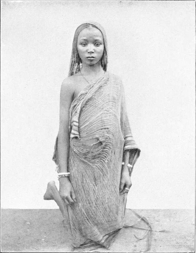
Villagers.The village Arabs own small herds of sheep and goats, a few donkeys, and some cattle, and sometimes a camel or two. Near the river they cultivate the islands and low ground, growing dura, beans, onions, etc. Inland, dukhn, simsim, and melons form the chief crops, with a little cotton in places. Throughout Eastern Kordofan gum is collected largely and exchanged for dura or cotton goods.
Very poor after the defeat of the Khalifa, in consequence of two good years, they are now becoming fairly prosperous. A large area round each hella (village) is under cultivation; in the gum country, the gardens show signs of attention, and both the men and women, instead of wearing the dirty waist-cloth seen when the province was first occupied, now wear Manchester cotton goods very largely. Silver ornaments are becoming common.
They have few firearms, and, as a rule, only carry a spear or small axe, even when travelling.
The most important tribe is the Gowama, living between El Obeid and El Agaba, and owning most of the gum country. The Shankab and Mesellemia live on the river; the Dar Hamid tribes and the Bederia, near El Obeid, are large tribes, but are now poor. There are several villages of Danagla and Jaalin scattered about. Jebel Atshan and Jebel Royan are inhabited by Zaghawa Arabs, relations of the large tribe in Northern Darfur, and at Ushut, north-west of El Obeid, there are a few Nimr from Eastern Darfur. Between Hashaba and Jebel Kon the Baza Arabs have many gardens, and near Yasin, half-way between Jebel Kon and Taiara, the Massadab have a few villages.
Nomads. Baggara.The nomad tribes are far superior to the villagers, both physically and mentally. The various Baggara[117] tribes live chiefly in Southern Kordofan, and only move north during the rains. They occupy the plains between El Obeid and the Bahr El Arab, and, being constantly in touch with the Nubas in the hills, were the chief slave-raiders. Their occupations are hunting for meat and skins, and occasionally for ivory, and herding their cattle. They own a good many horses, but when on the move carry their baggage on their bulls. They always carry arms. These consist of a large stabbing spear and small throwing spears. They own a certain number of Remington rifles, but have little ammunition, and their rifles are generally in bad order, as they cut down the stock and fore-end to lighten them and frequently remove the backsight, as it makes the rifle more convenient to carry.
They also carry a broad-bladed straight sword, which, when mounted, is slung over the high pommel of the saddle, the blade resting against the side of the saddle under the left thigh. The large spear (Kibis) is carried in the hand and the small spears (Tabaiig) are hung on the off side in a kind of quiver (Turkash). Shields are not used. A few of the richer men wear chain armour. They are by far the most warlike people in Kordofan, and are inclined to resent being no longer allowed to raid the blacks. The most important tribes are the Hawazma, between Sungikai and Jebel Eliri; the Messeria, near Sinut; the Kenana, between Lake No and Tendik; the Selim, on the White Nile south of Dar El Ahamda (a branch of the tribe situated in the Gezira and Upper Nile Provinces), the Habbania, now a small tribe at Sherkeila. The Homr, south of El Eddaiya towards the Bahr El Arab, are a large and fairly rich tribe; and the Gimma, near Gedid, the majority of whom, however, have permanent villages.
Camel owners.The camel owners (Siat El Ilbil) are less numerous, and live entirely in Northern Kordofan, only moving as far south as El Obeid when the water and grazing further north is exhausted. This depends, of course, on the rains. In the winter of 1902-03 the Kordofan tribes were all south of the Shageig-Kagmar road by the beginning of December. They are by far the pleasantest-mannered Arabs to meet, being independent, but hospitable and polite, though perhaps no more honest than the rest.
They live chiefly on camel or goats’ milk (the former is excellent) and dukhn; the latter they grow as a rain crop or buy with money earned by carrying goods, or else in exchange for sheep and goats. During the rains they all go north and east towards Dongola and beyond the Wadi Melh. Though most of the tribes still own herds of camels, goats, and sheep, large portions of some tribes live in villages and cultivate.
Of the camel-owning tribes in the province, the Hamar, once a large and prosperous tribe owning thousands of camels, now reduced in numbers, own but a few hundred. They have a good many sheep and goats. Their country (Dar Hamar) lies between Dar Hamid and the Darfur frontier. A large proportion of this tribe have now settled down in their former villages and cultivate near Nahud, Um Bel, and all along the frontier between Foga and Taweisha.
The Kababish still own many camels. They claim the country north of Kaja Katul and eastwards to Gabra.[118] Their great watering-places are Gabra, El Safia, Habisa, and Kagmar. A great part of the tribe under Sheikh Ali Tom suffered very heavily from the Dervish rule, and for having supplied us with camels in 1884-85, they had to face the vengeance of the Mahdi when we abandoned the country. Their cultivation is west of Omdurman.
The Shenabla graze their flocks and herds in Dar Hamid, but keep many goats and sheep near Shat. The Beni Jerar, now a small tribe, generally water their camels at Kagmar, but have cultivation near Shat, Um Deisis, and in the Busata district. Both the Shenabla and Beni Jerar were formerly under the head sheikh of the Kababish, but separated in Dervish times.
The Kawahla live north-west of Shageig, where they water during the dry season. They own many camels and do a good deal of carrying trade.
Blacks.In the northern hills the inhabitants called Nuba Arabs speak Arabic and have copied the habits of the village Arabs. They are black and have woolly hair but their features are more prominent than is the case with the southern tribes: they are not negroes. They live chiefly in straw tukls at the foot of their hills, though at Jebel Haraza some still live on the hillside. At Jebel Um Durrug the ruins of a very large village can be seen on the north side of Jebel Kershungal (the highest peak), near the largest well (a crack in the rock). At Jebel Abu Hadid there is also a large ruined village on the side of Jebel El Hella. At Jebel Atshan and Jebel Maganus, now entirely deserted by the Nubas, the ruins of small circular stone huts can be traced.
In the southern hills, as at Jebel Tagale, Jebel Daier, Jebel El Joghub, etc., the natives are pure, or nearly pure, Nubas, and speak Nuba, though most hills have different dialects. But there are also several hills occupied by escaped slaves. These consist of negroes of mixed origin, and call themselves after the tribe they escaped from. Thus at Jebel Eliri there are Hawazmas and Kawahlas; at Jebel Krondi, Hawazmas; and at Jebel Talodi, Homrs. They speak Arabic, and have little intercourse with the Nubas.
The Nubas are split up into innumerable tribes, each under a mek, who is generally on bad terms with his neighbours. Mek Geili, of Tagale, is one of the most powerful. He is a Jaalin by extraction; it is not uncommon for the mek to be of Arab descent. Each mek is assisted by a “kugur.” who acts as chief rain-maker and adviser to the tribe, his power being dependent chiefly on his astuteness. He is often the only man who can speak any Arabic.
Living in the zone of good rains they raise large crops of dura round the base of their hills. They make, in good years, large quantities of merissa (native beer), and drunkenness is very common. They own a good many cattle. The men, as a rule, wear no clothing, and the young women are usually contented with an elaborately plaited head of hair and a girdle of beads, from which a strip of cotton 3 or 4 inches wide depends, both in front and behind. But in places the latter garment is replaced by a strip of dom palm an inch wide. The married women generally wear either a cotton robe or a goat or sheep-skin. In many places the whole body is covered with a mixture of red clay and oil; and each tuft of hair, which is generally very short, is covered with a lump of red clay to make it stand out at right angles to the head. Cotton clothes, are, however, gradually coming into fashion in the less remote hills.
NUBA WOMAN, DAUGHTER AND BABY.
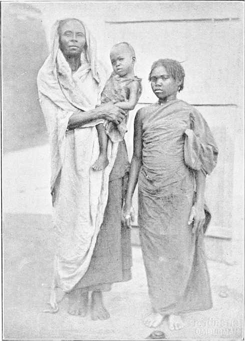
In most of the hills there are a good many rifles, but ammunition is scarce. The Remington rifle is the most common, but old Italian ones, magazine and single-loaders, are seen. Ammunition is manufactured locally, match-heads being often used as a substitute for caps.
A man who owns a rifle, even if his bandolier be empty, always carries it for appearance sake. In January, 1900, it was estimated that Mek Geili alone had 1,500 rifles. The other arms carried are knob-kerries and spears, but no shields. The blacks chiefly fear being raided by horsemen when they are cutting their crops on the plains at the foot of their hills. To disconcert the Arab horsemen they leave the trunks of the trees about 2 or 3 feet high when they clear the ground, and also make pit-falls with spikes at the bottom. A horse running against one of these stumps hidden in the dura gives his rider a bad fall and enables the fleeing black to turn on his pursuer or escape to the hills. Their houses used to be always built high up on the hill, and any gullies or valleys closed by stone walls high enough and strong enough to be easily defended, but now they are beginning to build in the plains. They also take care, as a rule, to have water inside their defences; they were thus able to hold out successfully against the Dervish expeditions which were sent against them from time to time. It is also probable that having been constantly raided for slaves by the Government troops they had discovered the best means of escape and of defence even before the Mahdia.
It is difficult to say how they will develop now that they no longer live in fear of the Arab. They are lazy, but have had no inducements to work. Easily angered, their quarrels do not seem to last long; in fact, they are primitive children who require constant watching lest they become unmanageable, and constant protection lest other races abuse their ignorance, improvidence, or credulity.
Habitations.In a few places, such as El Dueim and El Obeid, there are mud houses with flat roofs. But the natives mostly live in conical-shaped straw huts (tukls) or in box-shaped shelters called “rakubas.” The house is generally surrounded by a thorn fence, inside which the sheep and goats are kept at night.
Tukls are cylindrical buildings with conical roofs. They are generally built by driving forked stakes (shab) into the ground in a circle from 10 to 20 feet in diameter. A circle (kara) of similar size is then made, apart from the other circle, of strong tough twigs tied together every few inches with strips of bark. To form the roof, four poles are tied together at their small ends and the butts pushed into the kara to form a cone. A small circle of twigs is then lashed on near the top and more poles placed with their butts in the kara and their tops lashed to the upper circle. As many more horizontal bands of twigs as the size of the huts demand are then made, and the whole frame is lifted on to the forks of the uprights. The roof is then thatched with dura, or dukhn stalks, and the walls are built of the same material.
“Rakubas” are box-shaped huts made of poles and covered with grass or straw. They are useless in the rains but excellent at other times, as the walls, while keeping out the sun, let the wind through.
The camel-owning Arabs make tents of woollen blankets. They are exactly the shape of gipsy tents in England. The Baggara tribes make similar tents, but cover them with mats made of grass or reeds and tanned ox-hides called “dilla.” The old frames can frequently be seen on deserted camping grounds.
The Nubas, though they vary very much in skill, generally build better tukls than the Arabs. The walls are made of either stone, mud, or wattle and daub, the latter being sometimes ornamented with a pattern in red clay. The roofs are much better thatched than those of the Arabs and are given a steeper pitch.
The furniture of an Arab tukl consists of a few bedsteads (angarib), very short and narrow, and sometimes a mat. The cooking utensils consist of a grindstone (generally outside the door), a stone to cook kisra on, a few wooden dishes for food, some flat baskets and earthenware pots (kantûsh), spherical in shape, for water. Pillows of wood to support the head are used by the blacks, who go in for extensive head dresses. Small and very light axes are used for cutting wood, they are seldom more than an inch wide and 5 inches long. A dilwa or bucket made of a piece of soft leather suspended from a circle of wood by strings a few inches long, so that it can open out nearly flat at the bottom of the well when water is scarce, is used for drawing water.
Rope.Rope is made from the bark of trees, such as the tebeldi (Adansonia digitata), sayal (Acacia spirocarpa), kittr, and usher, which makes the best.
Fire.Fire is made by twirling a stick of marakh (Leptadenia spartium) on a piece of usher (Calotropis procera), or if no usher is available, two pieces of marakh are used. Two pieces of hard wood are also used at times, sand being put in the hole to increase friction.
3. Towns.
El Obeid.—El Obeid, the capital of Kordofan, is situated in lat. 13° 11′ north and long. 30° 14′ east. Its elevation has been given as between 1,700 and 2,000 feet. It is built on the side of a depression in the centre of which are the wells. These are from 60 to 80 feet deep, and give (except from March to June) a plentiful supply of water for the present population of about 10,000 people, but in former times, when the population was larger, there were frequently water famines.
The old mudiria is still standing and has been repaired. Barracks for a Sudanese battalion and details are being built, and the town laid out in squares. Most of the inhabitants, many of whom only come in for the dry season, live in tukls, but a good many mud-brick houses have been built by merchants. There is a large market, and a considerable trade is done in gum and cattle.
The old fortifications can still be traced in places, but most of the old buildings have disappeared.
The town was held by Mohammed Pasha Said against the Mahdi from 3rd September, 1882, till 17th January, 1883, when it fell (see p. 247). It is 158 miles from Dueim on the W. Nile and, therefore, 268 miles from Khartoum. It is 388 miles from El Fasher.
Bara.—Bara is now a small place, but there are excellent gardens there and a small market.
El Dueim.—El Dueim, on the Nile, is the port of Kordofan. Most of the merchandise for the interior is landed there, and gum is shipped to Omdurman. There is a good market. (Vide p. 56 for description.)
Nahud.—Nahud, situated 165 miles west of El Obeid and 80 miles south of Foga, is a new town of some 7,000 inhabitants. It is not mentioned in any of the old accounts of Kordofan, as before the decline of the Dervish rule it was a small place populated by Hamar and people from the river, such as Jaalin, Danagla, etc., who had originally gone out to trade in slaves. Gradually people collected there, so that the inhabitants consist of every tribe in Kordofan, the Hamar predominating. All the trade with Darfur passes through here, and there is a large market where cotton and trade goods can be purchased. Cattle is the chief trade. Gum is not in any demand, owing to cost of transport. Feathers and ivory are obtainable in fairly large quantities. India-rubber is brought in in small quantities. There is little crime there now; the market has been built, and there are some 40 good mud-brick shops owned by Greeks, Syrians, Jaalin, Danagla, etc. Dukhn is plentiful. When the town was first occupied drunkenness was very common amongst both sexes. Dura, simsim, and cotton are also brought into the market. It is the second town in Kordofan, and is increasing.
Taiara.—Taiara, formerly the centre of the gum trade, was destroyed by the Dervishes, and in December, 1899, consisted of but six huts. It is now the headquarters of a district and has a good market. There are several gum merchants there, besides agents of Omdurman firms. The place is rapidly growing.
4. Animals.
Cattle.The Baggara tribes have large herds of the hump variety, but they are seldom anxious to sell them. They are small, but their meat is of good quality. The bulls are used as pack-transport animals and are extremely docile. Cattle are generally watered every second day, but if grazing is scarce and they have to go far from the wells, it is not uncommon for them to go three or even four days without water. This applies especially to the cattle in Northern Kordofan. There is also a smaller humpless variety.
The Nubas own considerable herds but seldom sell them. Like the Dinkas and other blacks they regard cattle as a form of wealth which enables them to obtain wives.
Camels.These have also decreased to a terrible extent. The Kababish, Kawahla, Shanabla, Hamar, and Beni Jerar, who formerly had the whole of the carrying trade of Kordofan, are now hardly able to cope with it. All over the gum country Hawawir and other northern tribesmen are to be found with caravans of camels. The Hamar have almost ceased to be a camel-owning tribe, and it must be years before the supply of camels is at all large. The villagers own few camels, and the Baggara tribes none, as they cannot live south of lat. 13° 30′. In the Dinka country to the south it is not at all uncommon for people, especially children, to fly in dread at the sight of a camel.
Horses.The Baggara tribes own a good many horses. Some are ugly animals, all head and tail, and not up to much weight, but the larger proportion are small horses, up to weight, good looking and well bred. The Dongalawi horse is prized, but it is now scarce; horses, or rather ponies, are also imported from Abyssinia. These are far inferior, but ridden by Arabs they are more suited to the country, being very hardy. If trained they can do 60 miles without water and do not seem to suffer. Their price is generally £E.3 to £E.5, but a good one runs to £E.18.
Donkeys.There are a good many donkeys, chiefly among the villagers. Like the horses they can go for a couple of days without water. From Zereiga to Bint Joda (50 miles) or from Abu Zabbat to Nahud (65 miles) are quite common marches for donkeys.
Sheep and goats.Large numbers of sheep and goats are owned by all tribes. In the south there is a small and very active breed which seems to carry more meat in proportion to its size than the ordinary Arab breed.
Game.Elephants are found in Dar El Homr, Dar El Ahamda, Dar El Tagale, and Dar Jange. Elephants are very numerous in Dar El Homr from May until June, when they travel to Dar Fertit and towards Lake No.
Rhinoceros (both black and “white”) are found in Dar El Homr and Dar El Rizeigat.
Buffalo are found in Dar El Homr, Dar El Nuba and in Dar El Ahamda.
Lion, leopard, and cheetah are found all over Kordofan from south of Kaja Katul, and are very numerous in the south.
Giraffe are found south of El Eddaiya and are very plentiful all over Southern and South-Western Kordofan.
Roan-antelope are found in Southern Kordofan.
Kudu are found scattered all over Kordofan; most plentiful in Kaja and Talodi districts.
Hartebeeste (Jacksonii) are very plentiful in Southern Kordofan.
Tiang are plentiful in S. and S.E. and in Kaja and Foga districts; there is a different species to that found on the White Nile, etc., which has been identified as the “Damaliscus korrigum” of West Africa, vide App. C.
Oryx (white) are found in Dar Hamid and Kaja districts.
Ril or Addra Gazelle are found all over Northern and North-Western Kordofan, but are local. They are not found elsewhere in the Sudan.
Addax are found north of Jebel Fas. Rare.
Ariel are found near Gabra and as far south as Fachi Shoya, but not very far west of White Nile.
White-eared cob (Cobus leucotis) are found on the White Nile and in Dar Jange.
Mrs. Gray’s waterbuck are found in Dar Jange.
Waterbuck (two kinds) are found on the White Nile and in Dar Homr.
Reedbuck are found in Southern Kordofan.
Oribi, duiker, dig-dig, bushbuck, gazelle (four kinds) and warthog are found in most places south and south-west of Keilak.
Gazelle (three kinds), viz., Rufifrons, Dorcas, and Isabella, are plentiful in various part of Kordofan.
The “harnessed antelope” and eland are said to exist in the south.
Small Game.Hares, quail, partridge, jungle-fowl, bustard (four kinds), and guinea-fowl are plentiful in the south up to January.
5. Climate and Health.
The year in Kordofan is divided into three seasons, viz.:—
The Kharif, or rainy season, which commences usually about 15th of June and lasts until the end of September.
The Shita, or cold weather, from the beginning of October to the end of February.
The Seif, or hot weather, from March to the middle of June.
The Rainy Season.[119]—Towards the middle of June the wind changes to the south, and heavy clouds begin to collect in that quarter. These, in a very few days, bring a storm of rain, usually heralded by strong wind, clouds of dust and sand, and thunder and lightning. These storms appear every two or three days. Although a steady rain falls, occasionally for 24 days, it usually comes in the form of stormy showers. As the result of these showers, by the end of July, the ground, even in the villages and around Government buildings, become covered with rank green vegetation, which defies all efforts to destroy it. The rank smell from this grass, the numerous frogs, toads, and other reptiles it harbours, and the general lassitude produced by these surroundings, render life anything but enjoyable during the day, whilst sleep inside one’s house is rendered well nigh impossible at night by the steamy moistures of the air and attacks of sand flies and mosquitos.
The Cold Weather.—Towards the end of September the wind begins to blow from the north and a great change takes place. The fever decreases, until by the end of November there are only a few cases in hospital. The weather is delightfully cool and the breezes bracing and refreshing.
The Hot Weather.—The heat in El Obeid and Western Kordofan is not as great as in other parts of the Sudan; the maximum temperature being rarely above 106° Fahr., whilst the nights remain delightfully cool until the rains appear.
Altitude above the sea level, compiled by Major Prout, 1876:—[120]
Feet.
Helba 1,381
Bara 1,622 Wells 20 feet deep.
El Obeid 1,919 „ 80-130 „ „
Faki Don 1,743 „ 120 „ „
Hamdaui 1,734 „ 110 „ „
Magenis 1,820 „ 80 „ „
Um Dobau 1,704 „ 15 „ „
Gumburra 1,853
Tibri 2,072
Um Ratali 1,994
Shitangul 1,998
Aboir Tine 1,789
Abu Sinun Hella 1,928
Health.Most diseases in Kordofan may be included under one of two heads—malarial and venereal. Were it not for these classes of disease Kordofan might be considered a healthy country.
Malaria.—The fever is, perhaps, more often of the remittent type. Those attacked for the first time almost invariably have remittent fever; the subsequent attacks are either remittent or intermittent. During January and February, which are otherwise healthy months, a particularly sudden and severe type of remittent fever has been noticed. A patient, previously well, will lose consciousness in the course of an hour, and either die in a state of coma or only recover after weeks of convalescence. This apparently is the result of malaria contracted during the rains, as Egyptian and British officers who have spent a wet season here and afterwards left the district, have been attacked in this way whilst on leave in Cairo and England. The good effect of hypodermic injections of hydro-bromide of quinine in fever of this kind is worth recording.
Venereal Diseases of every kind rage, except in Dar Nuba, where the people make great efforts to prevent the spread of these diseases. Travellers should take precautions to prevent their guides and servants drinking out of their water-bottles.
Water-borne Diseases.—Of diseases traceable to an impure water supply there has been a remarkable freedom in El Obeid itself. In this garrison there have been only a few cases of dysentery and diarrhœa during the last three years. Amongst the inhabitants of the country further south, who derive their water supply from rain water collected in hollows during the rainy season or from shallow wells during the dry season, this is not always the case, as many cases of dysentery, tape worm, guinea worm (very prevalent), etc., coming from these parts testify.
Guinea Worm.—With regard to the guinea worm, there is not sufficient evidence to prove that it is contracted by washing or wading in water, as the natives state. It in all probability is taken into the system with drinking water. To avoid this pest all surface water or water that is likely to have been fouled by the natives wading in it (for the ova are introduced into the water in this way) should be boiled before being drunk.
Small-Pox is still common in the southern part of the district, and the faces of many of the inhabitants are scarred in consequence.
Pneumonia is common amongst the blacks during the cold weather, and a great many camels die from this disease.
Section 2.—Darfur.
Historical.[121]Darfur was formerly one of the line of ancient African Kingdoms stretching across the Continent from west to east, of which Wadai and Abyssinia are the only ones still surviving[122] as independent states. Up to the early part of the 18th century the Kings of Darfur had dominion over the country as far east as the Atbara; but the war-like Fungs, who at that time were one of the most powerful tribes of the Sudan, gradually drove the Darfurians back, and established their own authority on the banks of the White Nile. Vide p. 229.
In 1770 they wrested the Province of Kordofan from the Darfur kings, but five years later it was retaken by the latter, and remained under their control until conquered in 1822 by Mohammed Bey Dafterdar, the brother-in-law of Ismail Pasha, who was burnt at Shendi.
After the loss of Kordofan the Darfurians retired westwards and the kings then governed only a circumscribed area, of which Jebel Marra was the centre. This is the Darfur that was conquered and annexed to Egypt by Zubeir Pasha in 1874 and which is the Darfur of the present day.
Present boundaries.Modern Darfur in shape is a more or less regular parallelogram, 400 miles by 400 miles, and may be said to lie between N. Lat. 10° and 16° and E. Long. 22° and 27° 30′.
It is bounded on the north by Dar Bedaiat and the desert west of the Wadi Melh; on the east by Kordofan,[123] the frontier running from Kaja Serrug (Darfur) in a south-west direction to Dam Jamad (Kordofan) and thence in a southerly direction to the Bahr El Arab and Dar Fertit; Dar Habbania and Dar Taaisha belonging to Darfur. The western boundary leaves Dar Sula and Borgu or Wadai within the French sphere of influence and Dar Gimr and Dar Tama to Darfur.
Drainage.The watershed of Darfur, which forms part of that separating the basin of Lake Chad from that of the Nile, runs nearly north and south through the centre of the country. The chief features which define it are in the North Jebel Meidob (3,500 feet) connected with Jebel Tagabo further south by a plateau, the greatest altitude of which is about 1,200 feet, and further south Jebel Marra and its offshoots. To the south-west of these mountains, the main peaks of which rise to an altitude of some 6,000 feet, the plain is about 4,000 feet above the sea.
As might be expected the general direction of the drainage is east and west. In the north the country is so arid and the rains so meagre that the water draining eastwards towards the Wadi Melh soon sinks into the sandy soil and disappears. Similarly, further south the Wadis, chief of which is Wadi Ko, draining the east and south-east of the Marra group and which flow generally in a south-easterly direction towards the Bahr El Arab, an affluent of the Bahr El Ghazal, seldom if ever discharge water into that river. The Wadis Bulbul, Gendi, and Ibra, however, which spring from the more southern slopes of the watershed and also trend south-east, are believed to convey a considerable quantity of water into the Bahr El Arab during the rainy season.
To the west of the watershed the general trend of the wadis is south-west, the Wadi Sonot and Kia in the north, with their affluents draining the hills of Dar Tama, and most important of all the Wadi Azum which carries the drainage from the western slopes of Jebel Marra are thought to unite near Dar Sula and to flow, under the name of Bahr El Salamat, towards Lake Iro, though it is doubtful if their waters ever reach this marshy swamp which, in turn, drains into the Shari.
The drainage of the south-west of Darfur flows towards the River Mamun, a perennial stream, also an affluent of the Shari, which, of course, empties into the southern end of Lake Chad.
Water supply.Broadly it may be said that the country to the north and east of the Marra range resembles that of Kordofan in its character and usual dearth of water, whilst to the west, south-west, and south it is much better watered and more fertile. During the rains water is here everywhere plentiful, whilst at this season much of Southern Darfur becomes marshy and difficult to travel over. In the rainy season too the principal wadis, especially those in the south and south-west, are perfect torrents, and, although their beds are dry soon after the cessation of the rains, water is generally to be found in abundance held up by the clayey strata at a few feet below the surface. In Eastern Darfur the wells are of considerable depth and at great distances from each other, especially south of Dara and Taweisha, and the people are dependent to a great extent on water melons (batikh) and to a less extent on Tebeldi trees (Adansonia digitata) which are such a feature of Dar Hamar, the adjoining district of Kordofan.
The deepest wells are at Karnak, where water is only obtained at 250 feet. At Burush on the Fasher-Obeid road and on the road to Taweisha, and at Taweisha itself, the wells, which pass through strata of chalk and marl, average from 100 to 130 feet in depth.
At El Fasher the wells are of no great depth and at the end of the dry season water is obtainable at 35 feet.
The nearer one approaches the central group of mountains the depth at which water is found diminishes. At 3,200 feet above the sea it is found by excavating in the sandy beds of khors, but at 4,000 feet there is running water which becomes more abundant still further to the west of Jebel Marra.
Geology.The geological formation is very varied; in the west the mountains show a volcanic origin; in the north and south granite and sandstone are the prevailing rocks; in the east the soil is sandy and contains a quantity of iron, which is worked to a small extent.
In the east and north-east, granite predominates, with the exception of a strip between Foga and El Fasher, where red and white sandstone crops out.
In the north, Wadi Melit and the hills in its neighbourhood are of gneiss. To the north-east of this, granite again predominates at Saya, whilst still further north, Jebel Tagabo is of sandstone.
Jebel Meidob contains both sandstone and granite; this group has been much distorted by volcanic agency, and beds of lava are to be seen in all directions. To its south-west lies Bir El Melh,[124] an extinct crater, which to outward appearance is an insignificant hill, but has a depth of about 150 feet. Here is a small lake strongly impregnated with alkaline matter, while sweet water springs issue from the sandstone and granite declivities.
The Jebel Marra group is also of volcanic origin; lava and granite are to be found everywhere, but there is no sandstone; small peaks of pink granite crop up here and there between these mountains and El Fasher.
Stretching from the main group in a westerly direction for a distance of 30 or 40 miles is a huge dyke of white quartz with a sandstone plateau raised some 300 feet above the plain which is itself about 3,200 feet above sea level.
The inhabitants report a large lake of brackish water, from which salt can be obtained, on the north-eastern part of the mountain; while, at a day’s journey to the west, salt is also found at Karunga, and the Wadi Burka is strongly impregnated with soda.
In all the depressions sand rich in iron is met with.
In a southerly direction from Jebel Marra, there stretches a broad alluvial plain which is dotted all over with peaks of granite, giving the impression of a range of mountains, buried all but its highest points.
Inhabitants.The original tribes of the country are the Fors and the Dago; the latter ruled for centuries over the entire district from their inaccessible strongholds in Jebel Marra. Tradition relates[125] that about the 14th century the Tungur Arabs, emigrating south from Tunis, scattered throughout Bornu and Wadai, and eventually readied Darfur, the first arrivals being two brothers, Ali and Ahmed, who settled with their flocks on the western slopes of Jebel Marra. Of these brothers, Ahmed, nicknamed El Makur, was destined to become the founder of a new dynasty in Darfur. He became very popular with the then king Kor who not only gave him his favourite daughter as wife, but nominated him as his successor to the throne. Accordingly on Kor’s death Ahmed succeeded to the throne of Darfur, and on the news spreading to the Tungur of Wadai and Bornu, they flocked into the country in such numbers as to partially displace the Teigo. The only small settlements now left of the former rulers are near Dara, where there is a Dago sheikh, and also at Dar Sula, a long way to the west, where there is a semi-independent ruler called “Sultan Bekhit El Dagawi.”
A regular male succession was now established and a great grandson of Ahmed’s was the celebrated Sultan Dali, who wrote the Kitab-Dali or Penal Code. Another noted Sultan was Suleiman who took the name of Solon, who being the son of an Arab mother and himself married to an Arab woman, introduced Arab blood into the Royal Family. It was through him, some 400 years ago, that the country became Moslemised, and his descendants now proudly boast of their Arab descent and quite ignore the black element which is undoubtedly there, and which may account for the bitter enmity which exists between the ruling Darfur family and the Nomad Arabs of the country. At the end of the 18th century Sultan Abdel Rahman married a Beigo girl and her son, Mohammed El Fadl, became Sultan about the beginning of the next century. The Beigo tribe, originally slaves, were from that time declared free.
DARFUR GIRL.
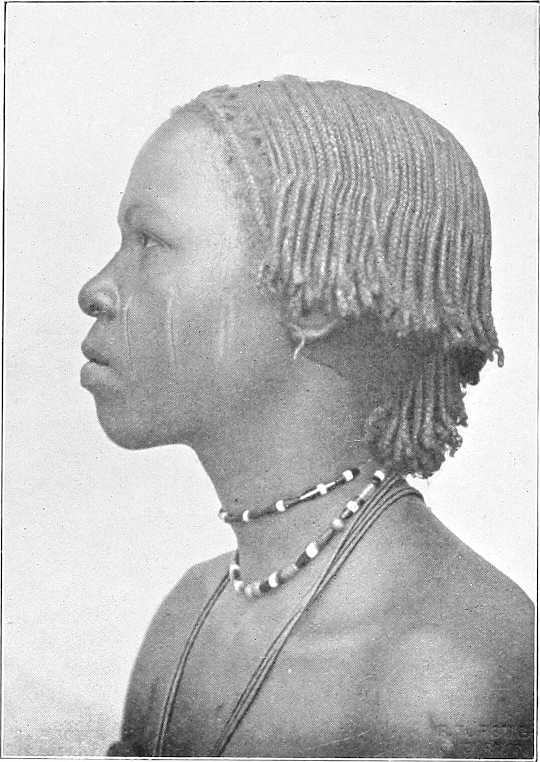
To turn to more recent times, Darfur has during the last 20 years been so devastated and depopulated that many formerly important tribes such as the Maharia, Nawaiba, Mahamid, Ereigat, Beni, Hussein, etc., have become so disintegrated and scattered that they now practically cease to exist as tribes and are seldom heard of.
The population of Darfur, prior to the Mahdi’s revolt, was estimated at 1,500,000. It is now probably less than half that number.
Furs.The Masabat and Kunjara, the ruling class of Fors, have their centre at El Fasher.
The Fors are clean and industrious. They may be found assembled under trees spinning, weaving cotton or plaiting mats, whilst the children will be herding the cattle. The men wear a jibba and drawers of coarse cotton stuff, whilst the women wear a piece of the same stuff made fast round the hips with the end thrown over the shoulder.
They live in tukls or conical huts, five or six of which arranged in a circle form a habitation.
Compared to other tribes, they are exceedingly clean feeders and very particular as to the manner in which their food is served, though corn and merissa are the main articles of consumption.
They are religious and fanatical, and study the Koran assiduously.
The mountainous stronghold of Jebel Marra is inhabited by the Jebelawin, the aboriginal inhabitants of Darfur.
OLD WOMAN OF DARFUR.
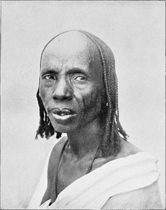
Arabs, etc.Other important tribes are in the north the Zaghawa and Zeiadia, in the east the Berti and Kaja, in the south-east the Maalia and Rizeigat, and in the south the Beni Helba, Habbania and Taaisha. The four last-named tribes are Baggara.[126] In the west are the Masabat and Tama.
In addition to these Darfur has a large sedentary population amongst whom are found the following tribes: Mima, Birged, Beigo, and Gimr, etc.
The present ruler of Darfur is Sultan Ali Dinar, a grandson of Sultan Mohammed Fadl; he was kept a prisoner at Omdurman during the Mahdia. In September, 1898, immediately after the defeat of the Khalifa at Kereri, he escaped to his native country. He now pays an annual tribute to the Sudan Government by which he has been officially recognised as its Agent in Darfur.
By kind permission of M. Venieris, Khartoum. THE DARFUR MAHMAL PASSING THROUGH OMDURMAN, 1904.
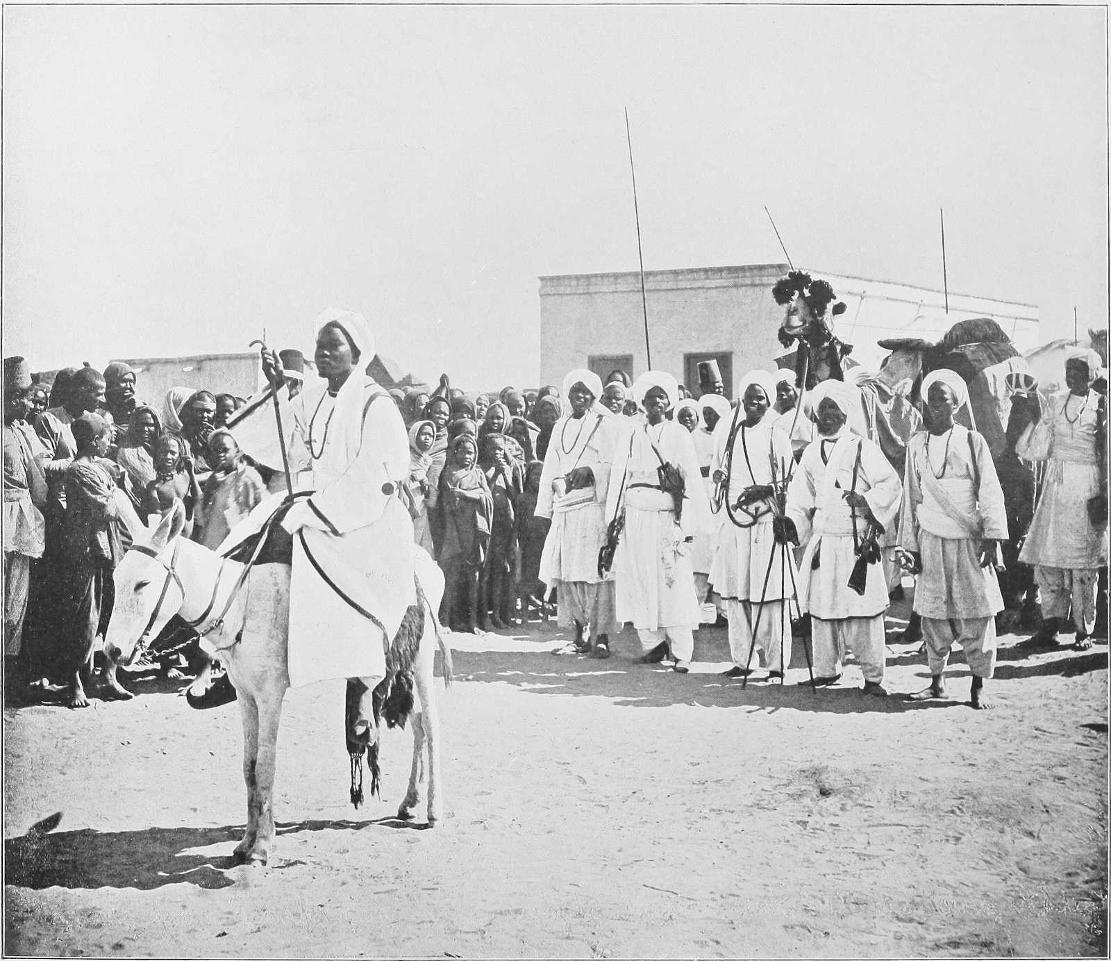
Administration.The management of the internal affairs of the country is left almost entirely to the sultan, though the Sudan Government sends him instructions and advice on certain matters from time to time as occasion arises. His judgments on all administrative questions are based on a combination of the Sharia Mohammedia and common law.
Army.The sultan maintains an army, organised on Dervish lines, of some 6,000 rifles, mostly of a more or less antiquated description. In case of need he could probably mobilise upwards of 2,000 horsemen. His chief commanders are Mohammed Ali Dedingawi, Adam Rijal, and Kamar El Din. The greater part of the army is quartered at El Fasher: the principal outlying garrison (about 500 men) is at Jebel El Hella on the Fasher-Obeid road.
Communications.Though in 1874 it took Colonel Mason, with a large caravan, from 100 to 150 days to reach Fasher from Cairo, nowadays a letter from Cairo could reach Fasher in 30 days without any difficulty.
In the old days the telegraph extended to Foga, now the furthest point to which it is proposed at present to extend it is Nahud, which is on the western frontier of Kordofan, and about 10 days’ camel ride from El Fasher.
(1) With Omdurman.There are two routes from Omdurman to El Fasher. That most generally used is viâ El Obeid, Nahud, and Jebel El Hella. The other, which has hitherto been avoided by merchants owing to the number of robbers in the neighbourhood of Kaja Katul, and Serrug, lies to the north of El Obeid, and, after passing the two above-mentioned places, joins the El Obeid-Nahud route at Jebel El Hella. Both are described in the route reports in Vol. II.
(2) With Wadai.There are three routes from Fasher to Abesher, the capital of Wadai. The direct road known as Sikkat El Masalat passes viâ Kebkebia (Darfur) and Bir Tawil to Abesher. This is not much used, in fact Ali Dinar has forbidden merchants or pilgrims to use either this or the northern route, as at Kebkebia there is a Fiki named Senin who has defied all the sultan’s efforts to induce him to tender his submission, and this road is consequently unsafe.
The northern route runs through Kutum, Dar Zaghawa, Dar Gimr, and Dar Tama; this is known as Sikkat Zaghawa. Owing to recent disturbances in Dar Zaghawa, this road is temporarily closed.
The southern route leads viâ Keibe and the Wadi Azum to Dar Sula and thence northwards to Abesher; this is known as Sikkat Dar Sula, and is the longest of the three, but it is comparatively safe.
Trade.Trade between Darfur and other parts of the Sudan has increased a good deal of late. The principal imports from the Nile are cotton goods (gomash), sugar, and tea; the exports are feathers, ivory, pepper, rhinoceros horns, and tobacco. The ivory, as a rule, comes from Dar Jange and Dar Fertit in the south. Owing to the recent disturbances in Wadai, ivory that formerly was exported through that country has been finding its way viâ El Fasher to Omdurman. A good many camels and cattle are imported from Wadai and are exported again viâ Nahud to the Nile.
Customs.A royalty of about 20 per cent. is taken on all ivory and feathers leaving Fasher, where the price of ivory is from £15 to £16 per 100 lbs.
Every laden camel entering Darfur pays PT.150 to PT.180, and each laden donkey PT.30 to PT.60.
Taxes.The taxes are three in number, Oshur, Zika, and Fitra. Oshur tax is assessed at the rate of ⅒th of the harvest, whilst Zika is 2 per cent. on all property animals, goods, or money.
Currency.The sultan has ordered that the present Egyptian coinage shall be current in Darfur, but merchants, finding they lose by it, are not anxious to introduce it. At present the principal coins in use are “Girsh Kabashi,” 20 of which equal one rial Mejidi, the equivalent of PT.16.
There are also a few “Girsh Garagandi” in use, these are of the same value as the “Kabashi.”
Transport animals.Camels are the best transport animals, except in the mountainous and southern regions, where mules, donkeys, or bullocks would be preferable.
Climate.The climate, of course, varies considerably. Fasher is healthy. In the south, where the rains are heavier, there must be the usual malaria at certain seasons. The climate of Jebel Marra is said to be cool and healthy.
Religion.The people of Darfur, as a whole, are followers of Islam, but the negroes in Jebel Marra, the Jebelawin, and those in the south and south-west have no religion. The late Sheikh Senussi wrote three times to Sultan Ali Dinar asking him to prepare Zawias for him, and to otherwise further his doctrine. Ali Dinar, however, considered it best to politely hold aloof from him, and there are now no Senussiites in El Fasher.
Produce.
The country may be divided into three sections with reference to the vegetation, i.e., the eastern zone of sandy steppes, the central mountains, and the western zone.
Corn.In the eastern zone, the cultivation of corn, in the shape of dukhn and a little dura, is the chief industry. A small quantity of simsim, cucumbers, pumpkins, and water melons are also grown. In certain depressions of the ground, where the presence of clay gives a stronger soil, cotton is produced, but in no great quantity.
The northern part of the country is almost uncultivated; and in the west, agriculture is pretty much the same as described for the eastern portion, except that owing to the greater quantity of water, more vegetables are grown.
The central mountainous district is the best watered and richest, and accordingly the most thickly populated. Small terraces, upon which gardens are laid out, are constructed all over the slopes of the hills. Here barley, wheat, dukhn,[127] dura, simsim, pumpkins, and melons are grown. In the small water-courses, onions are planted during the dry season. Honey of very good quality is collected in Jebel Marra.
Cotton.The cotton grown formerly was excellent. Now very little is grown. Arabs manufacture from wool a coarse material, but the Fors are ignorant of the process of its manufacture.
Salt.The production of salt is carried on in many parts of Darfur.
Camels.Camel breeding is the principal pursuit of the Arabs in the north and east of Darfur. North of 14° lat. camels used to be very numerous; they are now comparatively scarce. The Zeiadia, Maharia, and Bedaiat are the principal breeders.
The Arabs who breed camels occupy themselves with no other industry, and have even to buy the corn used in their households, which, with camel’s milk, satisfies all their wants.
Cattle.In the south, among the sedentary inhabitants, cattle and sheep are to be found in abundance.
The cattle are of two kinds: the humped species and the so-called African species, with long horns. The former are compact, well-made animals, and become very fat; the others are not worth much.
Sheep.The sheep have but little wool, but their flesh is good; among the Zaghawa there is a species with long curly hair. Zaghawa is leased to the present sultan’s sister, Miriam Tajer.
Goats.Goats abound everywhere.
Horses.The Baggara Arabs confine themselves chiefly to breeding cattle and horses. The Messeria are large horse-owners.
Horse breeding is largely carried on by the Mahamid tribe. The horses are small in size but very strong, and are said to be able on an emergency to travel for 60 hours without water. They are chiefly of a local breed (Tama).
The sultan has a stud farm in the Zeiadia country, with the object of improving and reviving the breed of horses.
Towns.
El Fasher.The old capital was Kobe, but at the end of the 17th century it was moved to El Fasher which is now the chief town. Colonel Gordon in 1877 described it as a most miserable place, though once a populous and thriving town under the sultans. It is 388 miles by road from El Obeid, or about 650 miles from Khartoum, and about 300 miles nearly due east from Abesher.
El Fasher or Tendelti stands mostly on the western bank of the Wadi Tendelti or Dindil in an angle formed by the junction of the latter with the Wadi El Ko.
The Tendelti has no current of its own, but is filled during the rains by the overflow from the Ko, and a dam, constructed near the junction, retains the water for some time. The wells supplying the town are all sunk in its bed.
The town now consists almost entirely of tukls and box-shaped straw sheds. There are about five or six mud houses, and the sultan intends to build himself a palace, the plans and material for which have been already sent to him from Khartoum.
On the town side, opposite the old palace, the old Government constructed a square fort with ditch and parapet. This is now demolished.
The population of the town was, in 1875, about 2,650. Of these—1,700 were natives, 300 Zeiadia Arabs, 250 Sâbah Arabs, 400 Melha Arabs. The population is now estimated at about 10,000.
Dara.There are now no other towns of importance. Dara, which used to be second in importance to Fasher, and the headquarters of a mudiria, is merely a small tukl village.
Melit.Melit is the name of rather a populous district in the north. Here there is a plentiful water supply from wells 9 to 12 feet deep in a khor, which also contains many date trees.
Tura.The ancient burial place of the sultans is at Tura in Jebel Marra.
ROUGH GENEALOGICAL TABLE TO SHOW THE RELATIONSHIP OF THE MORE RECENT SULTANS OF DARFUR.
Sultan Mohammed El Fadl (died 1839).
Sul. Hussein (died 1875). Hasaballa[128] (died in Cairo). Sul. Bosh (died 1878). Abu Bakr. Zakaria. Seif El Din. Nuerein. Imam, &c.
Sultan Ibrahim. Abdel Rahman. Dud Banga (surrendered 1898. Now lives at Gedaref, 1904.) Ali Dinar (present Sultan). Sul. Harun (died 1880).
Sul. Yusef (died 1888). Sagha (died 1889). Abu El Kheirat (died 1890). Abdel Hamid (now in Cairo). Hussein (executed by Ali Dinar, 1903.) Osman Abdel Rahman, late O. C. J. Hella (executed by Ali Dinar, 1903). Hamza (Heir Apparent). Ibrahim. Seif El Din, &c.
At present attached to the Staffs of the principal Commanders in Sultan Ali Dinar’s Army.
SHILLUK.
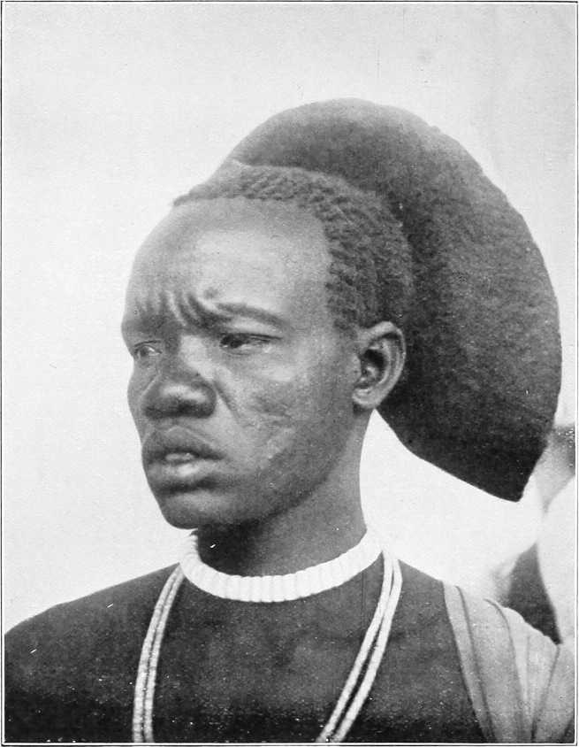
Section 3.—The Shilluks and their Country.[129]
The Shilluk nation, the only people in the Sudan who acknowledge one head as immediate ruler or mek, extends along the west bank of the Nile from Kaka in the north to Lake No in the south. There is also a colony along the banks of the Sobat, near its mouth, extending 35 miles up this river to Nagdyeb, and chiefly living on the north bank.
The country is almost entirely a grass country, and as a result its wealth consists almost entirely of cattle.
A large and increasing amount of dura and other vegetables is grown, but it is often barely enough for the needs of the population, and with bad harvests famines are constantly occurring.
Description of the people. Appearance.Physically, the Shilluks, Shulla, or Ojallo (native names) are a fine race. In colour they are glossy blue-black. The average height of the men is quite 5 feet 10 inches, and that of the women is in proportion. According to European ideas they are narrow in the shoulders and thin in the calves in proportion to their height, but they are capable of sustaining considerable fatigue on short rations, and are courageous and moral in their sexual relations.
Every man carries and cherishes a long spear, with a laurel-leaf-shaped blade and a tuft of ostrich feathers near the butt; when prepared for war he carries also a knob-kerry, an extra throwing spear or two, and a light oblong shield of wickerwork or hide. The hair is twisted by means of a mixture of gum, mud, and cow-dung, into a series of extraordinary shapes, e.g., cockscombs, “tam o’shanter”-like halos, plumes a foot high, knobs, etc., etc. Few clothes are worn, occasionally a twist of cloth or a leopard’s skin, but as a rule the men go stark naked. The women are more clothed. A large proportion of the Sudanese battalions are drawn from Shilluks, though no conscription is enforced.
History and religion.The legendary history and the religion of the Shilluks are related on page 197.
Character.In character they are haughty and independent, and hate foreigners, according to the lessons instilled by the older men who suffered under the “Turks,” the Danagla slave-dealers, and the Dervishes. Under the present regime it is hoped that this feeling will die out. They are also crafty, quarrelsome, and untrustworthy as a rule; at the same time they are thick-headed and obstinate; but, as aforesaid, their morals in relation to women are very good; they have a fine sense of discipline, and become very much attached to their leaders, whether black or white; they are exceedingly plucky, and they are the finest warriors in the Sudan.
Population.The country is thickly populated for its size. Right away from Kaka to Lake No is a continuous string of villages lying about a mile from the river. There are only two points in the whole of this distance at which the interval between villages exceeds two miles, and these are at the points where grazing is bad (between Akurwa and Nun, and between Nielwag and Nyagwado). There are, in addition, eight groups of villages which lie 12 to 22 miles inland, away from the river.
Villages.A careful census of the river villages in 1903 gave a result of 1,010 villages, 8,693 domiciles, and 39,312 souls.
Shilluk villages are invariably built in a circle, the open space in the centre containing nothing but a meeting-house for men only, and almost invariably a temple erected to a grandfather or great-grandfather of the reigning chief. Each domicile consists usually of three or four tukls, enclosed by a dura stalk fence. The houses are kept scrupulously clean by the women. A family occupies two or three huts; one is reserved for the householder with his wife, another as a cook-house, where merissa is also made, and the third is occupied by the retainers and children of the house. Dr. Schweinfurth records the existence of Shilluk villages of 200 huts. The largest village is Atwadoi, consisting of 120 domiciles, in a district of the same name north of Kodok. The constitutional laziness of the tribe does not prevent their erecting very well-built tukls, and many men are most proficient in thatching the roofs. The crest or peak of the tukl being completed, the workman descends, and a sheep is at once killed by the future occupant and eaten by the workmen, whose reward is completed by a further donation of two sheep.
Domestic life.A wife can be had for a milch cow and four to five oxen, but this is a high price to pay at present. This purchase money cannot be collected by many all their lives. The Shilluks keep one, two, or three wives; a very few exceed this number.
The Shilluk woman is fruitful; there are some with eight or nine children; three, four and five children seem to be the average issue. In former times, it is said, the number of children was much larger.
Having cost the man much money and trouble the woman is well looked after and treated. Aided by the girls she has she does her house work. She helps her husband honestly in the field. She is permitted to remain for weeks on a visit to her relatives. If disobedient the man gives her a thrashing on the back with a rope end, but this occurs very seldom.
The education of the children consists practically of the phrase, “Do just the same as you see me doing.”
The native at home knows of no science or profession, hence schools and house tasks are out of the question. Girls learn from their mothers house, field and plaiting work. The boys are all cattle-tenders. At the age of 13 to 15 years they start the cultivation of a small field, and grow up to manhood by degrees, acquiring the means for a house and a wife.
As long as they are young, children are obedient, but they take no notice of what the parents say as soon as they are able to carry out any work by themselves.
Cultivation.The cultivation carried on during the rainy season requires hard work, which the Shilluk is not inclined to give except for short periods at a time. The soil is, along the river, very rich and black, about 12 feet thick, and is named “do do”; inland it is poorer. Owing to the richness, weeds grow apace, and the land has to be weeded two or three times to avoid the young dura being choked. When gathered, thieves, mice, and elephants reduce the stock considerably, and even when he has produced, by dint of hard work, a fair pile of dura the native does not use it economically, for he eats a great deal at a time, gives generously to his poorer friends, and sells it badly.
Maize, beans, melons, ful (ground nuts), sesame, and cotton are also grown, but in only sufficient quantities for local wants. The cotton cultivation could probably be extended.
Cattle breeding.The chief occupation of the Shilluk is, however, cattle breeding. To him it represents property and wives. The amount of cattle in the country is unfortunately smaller than formerly, for it has been reduced largely by the depredations of the Danagla, the Dervishes, and even their own kings. In comparison with the Dinkas they are poor indeed, for a Dinka will willingly part with 20 or more oxen and cows for a wife, whereas the Shilluk can only pay one cow and three or four oxen with difficulty.
The cattle census of 1903 amounted to only 12,173 head of cattle and 63,473 sheep and goats in the whole country, but they are increasing. The cattle are large and of a good stamp, and breed well, but the sheep and goats (the former of whom have hair, not wool) are small and stunted. Many cattle die every year of disease, in spite of every care being taken. One-sixth part of the sheep and goats, it is said, die during the rains, and these animals are especially exposed, not only to crocodiles, but to glanders and a sort of guinea worm which burrows between the hoofs.
During the dry season herds migrate to different parts of the country, the majority of those owned by the central district crossing over to the east bank of the Nile, to return when the new grass springs up. Similarly the cattle of the Sobat Shilluks descend to the lagoons south of the Sobat and graze with the herds of Obai and Fennikang. All the youths and boys over 10 years old accompany them, leaving their homes for several weeks.
The grass of Shilluk land generally gives little nourishment. Milk is therefore scanty. If one possesses even herds of cows the result in milk is small; curiously enough three or four out of every 10 are barren. A cow is never slaughtered; like man, it ought to expire by itself. Oxen are only killed on festal occasions, such as funeral dinners, etc. Mutton and goats’ meat are usually only eaten at festival dinners and ceremonies, or when the animal expires; or in cases of human sickness.
It is therefore very difficult to buy cattle from the Shilluks, for they cannot obtain wives for cash. It is simply impossible to buy a milch cow.
Old soldiers who have returned home to their native land, where they never get a piece of meat to eat, hanker after the flesh pots of Egypt, where they had meat nearly every day.
Crafts.The Shilluks have their own blacksmiths, potters, thatchers, pipemakers, surgeons, boat-builders, and basket and hair plaiters.
The blacksmiths are very skilful; they prepare spears, spades for building, small axes, fishing rods, big harpoons, picks, arm rings, bells and chains, etc. Their handicraft is a travelling one; they take their tools and go about from one place to another. The pay of a blacksmith is good. The employer has to support the man working for him, and makes him a present of sheep besides.
Pottery is the handicraft of the women. They make pots, pitchers, heads for smoking pipes in any form, and make them well. They are paid in food for their work.
The thatchers make not only watertight but also very neat roofs; a skilful European cannot make one better.
Snake stings and damage from blows or spear wounds are numerous. For the treatment of these evils the surgeons are called in. In their work they chop and cut most unmercifully, but although they inflict much pain they often save lives.
To make canoes out of crooked pieces of wood is the work of the ship-builders, and, with the poor tools they have, they make fairly satisfactory boats.
The plaiting of baskets and straw mats is done by both sexes. The species of grass here being not well adapted for plaiting, the production is not grand; however, the result meets the demand.
The nimbus-like and other head-dresses of hair worn by the Shilluks are masterly work.
Families carry on these respective trades for generations, and the father and mother impart their skill to their children and next relatives.
Building houses, carving and polishing clubs and spear sticks and other common work is understood by every Shilluk.
There are villages which are especially distinguished; some in fishing or hunting, some in cattle-breeding, others in cultivating dura, etc.
Occupation.During the rainy season, old and young, men and women, are busy; anyone who visits the country at this time of the year would believe them to be a hardworking people. At this time work is very fatiguing; no European could do it on such a meagre fare as that of the Shilluks. Diseases, fever, dysentery, colds, coughs, and pulmonary ailments are also rife at this season, both among the natives and their cattle.
During the dry season, however, there is not much to do; at most there are houses to be built and repaired, and this is done by young men. The old ones, viz., from 35 years onwards, do nothing but lie about or pay visits.
At this time of the year Shilluks begin to travel. Relatives pay mutual visits, and marriageable young men go to the Nuers and Dinkas with spears, wire, stuffs and dura, which they exchange for sheep and calves.
Industries. Fishing.Fishing is precariously carried out in shallow waters, either by spearing (horizontally, with bow-shaped fishing spears) or by pouncing on the fish with hemispherical wicker traps somewhat like lobster pots. Neither nets nor fishing lines appear to be used. Hippo hunting.Hippopotamus hunting is done by combined parties in canoes or dug-outs, harpooning the hippopotamus and despatching him with spears when he comes to the surface to breathe. These animals, it may be remarked in passing, are very savage, doing much harm on the land and gratuitously attacking canoes, etc., in the water.
Climate.From January to April the climate is not bad, though April is the warmest month of the year. June to September constitutes the rainy season,[130] and from October to December the country is flooded with water: but the marshes and khors all dry up by April. From November to April the climate, though certainly not perfect, has little effect on a healthy constitution, provided good food, water, clothing, and a house are available. October is perhaps the worst month of the year.
SHILLUK WARRIORS.
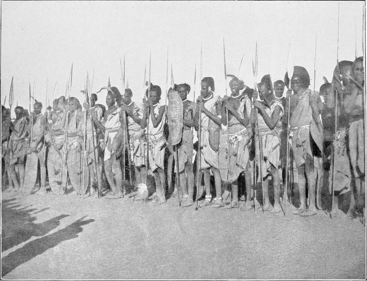
Relations with the Dinkas.The Shilluks do not, as a rule, agree well with the Dinkas, and there are big contrasts between the two races. The Dinka possesses many cattle and prepares his food with milk, whilst the Shilluk has only a few cattle and sprinkles his food with the dust obtained from drying and grinding dura stalks; for this he is despised by the Dinka.
Taken on the whole, the Dinkas are much more intelligent than the Shilluks. When Shilluk boys are unable to find a reply to the pointed remarks of a Dinka boy, they raise their sticks threateningly and say “The Dinka boy has a sharp tongue and must be flogged till he is quiet,” which generally stops the rather vulgar expressions used by Dinka boys.
The Dinkas are said to have formerly lived on the right bank of the lower Sobat, but were driven inland by the Shilluks.
Incited by a few Arabs, the Shilluks in former times used to raid the Dinkas and carry away their women and cattle. They however live peaceably now, thanks to the fear they have of the new Government. The two races now and then pay mutual visits, and also intermarry occasionally; a certain amount of trade is carried on between them.
Arab and other immigrants.There are a few Selim Baggara in the neighbourhood of Kaka, but these people appear to visit the district only after the harvest to purchase dura from the Shilluks, which they are too indolent to cultivate themselves.
The Kenana Arabs, under Sheikh Faki Hamed, occupy, though they are not allowed to monopolise, the wells at Atara. They are disliked by the Shilluks on account of their dirty habits.
Another branch of the Kenana Arabs occupy a village close to Fadiang. This branch of the tribe dwells in 60 domiciles. Fama (Sheikh Yogagieb Wad Awell), a sub-district of Nyagir, contains a mixed population of Nubawis and Shilluks; the former cultivate dura largely. They were originally driven into this district by the Khalifa’s people when the latter were at Fungor, and under the Sheikh Nail they inhabit five villages, consisting of 104 domiciles, and are subject to the Shilluk Sheikh Yogagieb Wad Awel. In Fama there is also a Gowama Arab village of 40 dwellings, under Sheikh Abu El Gasim, who collected these people at Taiara on the approach of the Khalifa, and permanently settled them in his present village. The list of immigrants to Fama district is completed by the mention of the Hawazma Arabs, under Sheikh Abu El Wahab Walad Handigai. From their own account they are fearless hunters of the elephant.
A sprinkling of Kenana Arabs is to be found temporarily living in villages as far south as Dusim, and a family or two of Felata hail from Jebel Eliri, but these are not permanent residents.
Administration.Since time immemorial the Shilluk nation has been governed by a Mek or King, and the list of reigning monarchs since the beginning is known to every well-educated Shilluk (vide p. 199). For administrative purposes the country has been divided for a long time into two provinces, that of Gerr (sub-divided into Kaka, or Moama, and Kodok). which extends to Bol (inclusive), and that of Loak, which extends from Fadiet (south of Bol) to Tonga and Lake No. Each of the three districts is under a head sheikh, residing in Oriang, Debalo, and Nyabanjo respectively, and the whole is subject to a mek or king, elected in a ceremonious manner by all the headmen of the sub-districts.
Up till the last representative, Kur Wad Nedok, the meks had supreme power, which appears to have been wielded in a somewhat arbitrary manner. Wad Nedok was deposed in the spring of 1903 for numerous malpractices, and his successor, Fadiet Wad Kwad Keir, is now limited in power, and is subservient in most things to the Governor of the Upper Nile Province, a British officer resident in the town of Kodok. (Vide Chap. I, p. 2).
For administration the country is still further divided into two provinces, the northern and southern, containing 29 districts altogether; the principal ones are:—
Northern Province.
Name of District. Name of Head Sheikh.
Ashargo Kudyit Wad Edor.
Golo Deng Wad Aiwol.
Southern Province.
Name of District. Name of Head Sheikh.
Awarajok Lual Wad Agok.
Dusim Amailek Wad Amosh.
Fennikang Akurwat.
Tonga Yang Jok.
Roads.A good track exists on either bank from Delal, south of Kaka, to Fennikang, south of Taufikia. South of this again many villages can be reached only by crossing deep khors which are filled with water all the year round. The Lolle river, nearly 200 yards wide throughout, flows past the villages of the districts Tonga and Fennikang. South of the Sobat mouth, a branch of the White Nile flows close to the villages of Dusim, Tuara, Oashi, Awarajok, and Fannidwai, and emerges into the main stream at a village named Warajok, where the telegraph cable crosses the river. This stream is about 13 feet deep throughout. It is known to old native navigators as the Bahr El Harami; sailing boats with contraband used to take this course in preference to passing the Government station of Taufikia.
Game.There is little game in the thickly inhabited Shilluk country itself. A little way inland, however, elephant, lion, antelope, etc., are plentiful, and more especially is this the case near the river towards Lake No. The neighbourhood of Kaka and north of it is also a grand game country.
APPENDIX.
History and Religion of the Shilluks.
In the beginning was Jo-uk, the Great Creator, and he created a great white cow, who came up out of the Nile and was called Deung Adok. The white cow gave birth to a man-child whom she nursed and named Kola (Kollo); Kola begat Umak Ra or Omaro, who begat Makwa or Wad Maul, who begat Ukwa. These people lived in a far off country, nobody knows where. (Bahr El Ghazal (?), Jur tribe (?) according to linguistic links).
Ukwa was one day sitting near the river when he saw two lovely maidens with long hair rise out of the river and play about in the shallows. He saw them many times after that, but they would have nothing to do with him and merely laughed at him. It should be mentioned that their lower extremities were like those of a crocodile.