Volume 1 — CHAPTER VI. (continued 2)
Reading edition
Grand solid rock peaks in places spring out from the ridges in a curious manner, and by their precipitous appearance would probably tax the resource of the most skilled Alpine climbers to reach their summits. We were able to learn nothing regarding the customs or habits of these natives, and, in fact, from the time we left Anuak country until we reached the Uganda Protectorate had to carry out all conversation by signs. Judging by the great display of beads made, for trading purposes I have little doubt but that red, blue and white beads would be readily taken in exchange for food. The small bead known as “pound” beads would, I think, be far less popular than a slightly larger variety about the size of a pea. The beads should be opaque, and the ordinary glass beads procurable in Cairo, I fancy, would be little sought after.
Karuno.To the south of Boma and some short distance away from the foot of the hills, a pleasantly wooded tract of country is traversed, consisting of alternate plains of open bush and grass land, whilst water is obtained from khors running in a westerly direction across this plain, before turning north. Further south, again, however, a most uninviting dried up plain, which, after rains, would probably be converted into heavy bog, is met with, and water now becomes a most-serious consideration as far as about lat. 5° 30′ north, where a broad sandy-bedded khor winds its way across the plain in a westerly direction. Along this river bed we found the Karuno tribe settled in considerable numbers. They appeared to be a somewhat powerful tribe, and were certainly the most elaborately bedecked and prosperous looking set of men we saw during our journey. They possessed large numbers of cattle, goats and sheep, and donkeys, and also grow grain along the banks of the Karuno. Like all the natives of these regions, they are extremely suspicious of strangers, and though not unfriendly, are by no means anxious, it seemed to us, to have anything to do with Europeans. I do not remember these people having ever before been mentioned by any traveller; but on comparing my map with Mr. Donaldson Smith’s we seemed most obviously to be at the place shown by him as inhabited by the Magois tribe. On enquiring of these natives where the Magois were, they pointed away across the plain to the west, and gave us to understand they had been driven away in that direction by the Turkana, who had come up in force from the south. Although we tried to induce the Karuno people to bring grain or goats and sheep into camp for sale, they would not do so, nor would they even provide us with guides. This is probably more due to the fear these natives entertain of travelling into their neighbour’s country than from any unfriendly motives. Here, where raids and counter-raids are frequently being indulged in, considerable hostility naturally exists between the several tribes living next each other. The Karuno in some respects are not unlike the Turkana, except that their head-dress is not a long pendant bag-shaped one, but more like a squat chignon, which is stuck full of fine vari-coloured ostrich feathers. Beads are worn by them in great quantities, chiefly red, white, and a variegated one known in East Africa as “Punda malia” (zebra). Many of the young warriors in addition to numerous strings round the neck, had solid bands of beads—similar to those we saw in Boma—fastened across the forehead. The elders have most handsome head-dresses made of cowrie shells, whilst others again wore skull caps made of small white and red beads worked into a neat design of many circles. Physically, the men are well set up and sturdy, though they do not run to height much and are probably little above the average stature.
The women are not unlike the Turkana, and weave their hair into straight ringlets which fall round the head. They also wear beads in great numbers round the neck, whilst the lower part of the body is covered with a skin apron, cut away at the side with a flap in front and a long trailing tail arrangement behind.
In addition to long handled spears, the men carry short stabbing spears, and oblong-shaped hide shields.
Exactly what extent of country the Karuno occupy I can hardly say, but I should imagine they do not exist further east than the foot of the escarpment, where the country becomes thickly wooded with thorn bush. In a westerly direction they probably do not extend more than 2 or 3 miles beyond where we first struck the Karuno river bed, leaving an uninhabited area of country between themselves and the Magois. After leaving the Karuno, and striking at first in a south-easterly, and later in an easterly direction, we reached and travelled along the foot of a rocky escarpment through an irregular bay, as it were, in the hills. The valley, between our line of march and broken hills to the south, was thickly wooded with thorn bush, and water was difficult to find. We saw a few old grass huts of natives, which had been deserted for some months previously, but saw no signs of human life. It is probable that this tract of country can only be occupied during the rainy season of the year, owing to the extreme scarcity of water.
Musha.After we had worked our way through these hills, finally crossing the eastern ridge by an easy pass, we found ourselves in a broad plain, thickly covered with thorn bush. Some 30 miles east more hills seemed to bar progress in that direction, whilst to the south the thorny plain appeared to extend for some 40 miles to the foot of the high mountain masses to the west of Lake Rudolf. We were now in the tract of country called by Dr. Donaldson Smith, Musha. The thorn-bush plain terminated to the north at the foot of two lofty mountains, the more westerly one of which attains a height of close on 6,000 feet, whilst the loftier mass to the south-east of it (previously known to me as Mount Naita.Mount Naita, and called by Dr. Donaldson Smith, Etua; whilst in Bottégo’s map it is named Aguzzo) reaches a height of about 7,300 feet. We passed numerous kraals whilst journeying in an easterly direction across this plain, which had all been temporarily abandoned by the natives, with whom we could get no intercourse, as they refused to approach us. On several occasions, when we saw two or three natives watching us from a distance, men were sent out to try and induce them to come into camp, but they fled before our men could get within even shouting distance of them. We were most anxious to obtain the service of guides, as the country before us was unknown, and the anxieties regarding water had become very great. It would appear, judging by the tracks we saw, that the Musha possess much livestock, consisting of camels, cattle, donkeys, goats, and sheep. In the thick bush, however, these people had little difficulty in driving them away and concealing their animals until we had passed, when presumably they returned again to their kraals. On one occasion, however, our advent was unexpected, as near our camping ground some of our party surprised two or three Musha, who were tending a flock of over 200 goats and sheep, and perhaps a dozen donkeys. The natives fled, leaving everything behind in their little enclosures. Strict orders were issued that these animals were not to be touched, as we hoped by so doing we might induce the natives to understand that we were not a marauding expedition, and were desirous of opening friendly intercourse with them. The animals were left alone all that day and night, but the Musha evidently feared to return, and when we marched off next morning the donkeys gave us a parting bray, which was the nearest approach to friendly intercourse we experienced in this neighbourhood, as we never saw another Musha man during the rest of our journey. In due course we crossed another low range of hills to the south of that grand mountain, Naita, and entered another wooded valley, which ultimately joined that of the River Sacchi, where we arrived on the 1st April, and our difficulties regarding water for the present were at an end. I would here remark that perhaps for nine months in the year, for a large party to cross this bit of country from Boma to the Sacchi, by the route followed by us, would be a most risky undertaking owing to the extreme scarcity of water. The many watercourses shown on the map were found to be almost without exception merely dry stony beds in which no water was procurable by digging. Fortunately, about the 20th March, rain had fallen to the east of where we then were, and by extraordinary good luck we subsequently found pools at intervals, after long continued search. One point worthy of note is that, in spite of previous rain, we seldom found water in the actual nullah beds, as, owing to their stony nature, the water runs off at once. What water was found was nearly always in depressions some distance away from the banks of these nullahs, where the clayey soil prevented percolation, and retained water in pools until it became evaporated in due course by the hot sun.
ANUAK WOMEN.
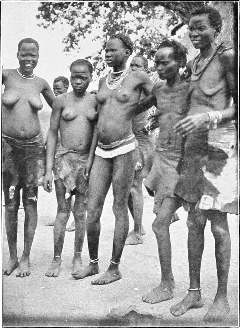
On our previous visit to Lake Rudolf from the south, our old Suk guide, Nyanga by name, had on several occasions pointed out to me the striking Naita peak away to the north-west, and told me that the country thereabouts was the most dreadful one he knew for scarcity of water. I believed him, as he was about the most knowledgable and intelligent native of his class regarding the geography of the country that I have ever met. His information had now been verified by us, and it was with a sigh of relief we found the Sacchi river.Sacchi a running stream. To the Swahilis the tract of country we had traversed was always known as Donyiro, which name appears on the map prepared by the Macdonald expedition.
From very imperfect data I am inclined to think that between our southerly route from Boma and the valley of the Sacchi the escarpment we skirted is the edge of a fine hilly plateau,[105] varying in height probably from 3,000 to 5,000 feet above sea level. I imagine all that tract of country to be a fertile and probably well-watered region, very much like Boma itself. Whether it is thickly populated it is difficult to say, as the country is absolutely unknown to Europeans, but to traverse it from north to south and east to west with mule transport would probably be most interesting. It would probably be almost too difficult for any pack animals except mules and perhaps donkeys. The much talked of gold, which is discussed by our Swahilis as existing in those parts, might also be found, although I must admit we never saw any gold ornaments worn by natives in the plains bordering that country.
Game.In Sudan territory south of the Sobat the following species are known to exist: Elephant, buffalo, giraffe, rhinoceros, zebra roan-antelope, waterbuck, Mrs. Grey’s waterbuck (cobus maria), white-eared cob (cobus leucotis), Uganda cob, bushbuck, reedbuck, Jackson’s hartebeeste, tiang, lion, leopard, etc.
(g) The Upper Pibor.
General.In August, 1904, the head waters of the so-called Pibor were explored by Lieutenant D. C. Comyn, Black Watch. It was found that 17 miles above the Akobo junction the river bifurcated, one branch known as the Agwei[106] apparently coming from the E. and S.E., the other, known by the Anuaks as Nyanabek, by the Nuers as Kang, and by the Agibbas as Natila, from the S. and S.W.
Following the latter branch, without encountering any serious sudd obstructions, Lieutenant Comyn succeeded, with the aid of a steam launch, in reaching a point which appeared to him to be very near the source of this important feeder of the Pibor.
Source.The flooded plain in which the river seemingly has its origin, is according to Lieutenant Comyn’s sketch, about 60 miles due E. of Bor, and 170 miles by river above the Akobo junction.
Banks.The banks of the Natila are as a rule ill-defined, swampy and sudd-fringed; in places they appear to be as much as 200 to 250 yards apart.
Almost throughout its course the banks were more or less inundated, the left bank being usually the higher, and in its upper reaches the plain was flooded to a depth of a foot or more for many miles round.
Water-way.The water-way varied from 20 to 70 yards in width, and about 20 miles above the Akobo junction, what appeared to be a sudd-covered lake, some 800 yards broad and 6 miles in length, was traversed by a deep and tortuous channel 20 to 30 yards wide.
Depth.The average depth for the first 130 miles was found to be about 20 feet, but in the next 40 miles the river gradually shoaled to about 15 inches, and the direction of its course was then only faintly distinguishable by the band of light-green grass which blocked its bed and precluded further progress.
Current.The current varied from ¾ to 2 miles per hour, the rise and fall of the river apparently depending largely on the local rainfall. In the dry season the plain, and, according to the Agibbas, the river itself dries up.
Fuel.Fuel is plentiful everywhere, the river being fringed with a belt of talh and heglig trees for the greater part of its course.
J. Atin.J. Atin, standing on the left bank, about 1½ miles from the river and about 100 miles from the Akobo junction, forms a conspicuous landmark. It is a solid rocky mass about 2 miles in circumference, and has twin peaks some 400 feet above the plain.
Gordon is said to have marched up the right bank in 1878 (?) and to have crossed to J. Atin, and to have marched thence westwards to the Nile through the Beir or Beri country.
Inhabitants.As is stated on p. 136 the inhabitants of the Lower Pibor are Nuers and a few of the less powerful Anuaks. On the Upper Pibor or Natila a tribe known as the Agibba were found, their first village being Nyanabek, about 70 miles S. of the Akobo. For the next 60 miles villages were frequently seen.
Agibba tribe.Lieutenant Comyn gives the following account of the Agibba tribe, who appear to strongly resemble the Nuers, and also in some respects the Turkana:—
“The Agibbas are a warlike tribe, feared by and fearing the Nuers. Their other neighbours, the Anuaks and Dinkas, they look on with contempt, and buy their suksuk from them. The Abyssinians do not harry this part of the tribe. A few men know the Nuer, Dinka and Anuak dialect. Their physique is good, but their stature is not uniform. Many seem to suffer from hydrocele, and I saw one man with elephantiasis in the leg. They are armed with roughly-made spears of various shapes, wrist knives, and an oblong shield of giraffe hide, and invariably carry their head-rest to sit upon. Their huts are rudely built, of a bee-hive shape, and about the same size as an ordinary tukl.”
“They appear to have no canoes, and I saw no fishing-spears, though plenty of fish baskets. Their ivory ornaments are old and small. The principal men wear over the right elbow a bunch of giraffe tails, the band ornamented with cowrie shells. Their clothing consists of a belt round the waist, and, in front and behind (if a man is well off), a skin often embroidered and edged with beads—most wear a 3½-inch band of red beads with a 1-inch line down the centre across their foreheads. Some of the older men had a bead-covered bowl on their heads instead. The hair of the younger men was dressed very neatly, like an inverted soup plate with the part over the forehead cut oft. They have all sorts of suksuk. What they asked for were (in order of preference) cowrie shells, beads (janitor), brass wire, red, white and other beads. The head sheikh, whose name I think is Nadgweir (they were very averse to telling it) seems a man of character. All seem afraid of him, and said if they took up spears without his permission he would cut their throats. I saw but half-a-dozen of women and no children.”
Table of Distances along the Sobat.
Place. Intermediate. From Sobat Mouth. From Khartoum.
Miles. Kilometres. Miles. Kilometres. Miles. Kilometres.
American Mission (Tatug or Deleib) 5½ 9 5½ 9 524 843
Khor Filus 4 6½ 9½ 15½ 528 849½
Gokjak 10 16 19½ 32 538 865½
Abwong 63 101 82½ 133 601 966
Nasser 107 172 189½ 306 708 1138
Pibor Mouth 27½ 44 217 349 735½ 1182
Machar 36½ 58½ 253½ 406½ 772 1240½
Jokau 16 26 269½ 434 788 1267
Balankun 9 14½ 278½ 448½ 797 1282
Itang 36 58 314½ 507 833 1340
Fenkio 23 37 337½ 544 856 1377
Gambela 18 29 355½ 572½ 874 1406
Baro Ford 26 42 381½ 614 900 1448