Chapter VII · (continued 2)
Reading edition
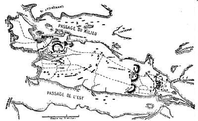
RHODE ISLAND, August, 1778.
Sketched from a colored plan among the Sparks maps at Cornell University, which follows a plan made for Lafayette. It is called Plan de Rhode Island avec les différentes opérations de la flotte Française, et des troupes Américaines, commandées par le Major Général Sullivan, contre les forces de terre et de mer des Anglais, depuis le 9 Août, jusqu'à la nuit du 30 au 31 du même mois, 1778, que les Américains ont fait leur Retraite.
Key: The British works are solid black, their troops diagonally black and white; the American works of open lines, and their troops shaded obliquely. The British in Newport were protected on the water side by batteries (3, 3, 3); on the land side by an inner line of defence (4) and an outer line (5, 6, 7, 8), with nine guns (8) commanding the water approach by Easton Pond. At the north end of the island they had works (16, 18, 20,—solid black) to resist attack from the mainland. Upon the entrance of the French fleet by the Newport batteries, the English evacuated these advanced posts, and some frigates were sent into the East passage (15) to protect the movements of the Americans, who, moving over to the island, threw up redoubts (17) to protect their first position, and erected a battery of two guns at 20 to cover their retreat across Howland's Ferry, should that become necessary. They now advanced, and on August 15th took position on the line 11, and began their approaches (9). The French had landed from the ships at 22, and joined the left wing under Lafayette. The redoubts on the extreme left and right of the line 11 were never completed. The fire from the parallels was kept up from the 19th to the evening of the 28th, when the retreat began, and the Americans in the night of the 28th, erected the breastworks (19, 19) flanking the abandoned British forts (18), and during the night of the 30th left the island by Howland's Ferry, while the British were at Turkey Hill (16). The position of the British fleet was at 1.
Sparks has added to the plan these references: 12, Overing's house, where Col. Barton captured Gen. Prescott; 13, guard-house; 14, round redoubt thrown up by the New Hampshire militia,—skirmishing commenced here under Col. Laurens; and 10, Bishop Berkeley's house. The broken lines are roads.
The most elaborate of the manuscript contemporary maps is one belonging to the Mass. Hist. Society, which is reproduced, full size, in the Proceedings of that society (vol. xx. p. 350), and is given in its essential parts in Gen. G. W. Cullum's Historical Sketch of the Fortification Defences of Narragansett Bay (Washington, 1884). It is on a scale of nearly an inch and a quarter to the mile, and is signed "J. Denison scripsit." The French fleet is represented as going out to join battle with Lord Howe's fleet, exchanging shots with the English shore batteries, which are more numerous than in the Lafayette map. The French ships in the East passage are shown as sailing out to sea, to join D'Estaing on his way to Boston. In the battle of the 29th, near Butt's Hill, English ships are drawn as engaging both the American right and a battery on the Bristol shore. The first line of the Americans stretches across the island in this order from west to east,—Livingston, Varnum, Cornell, Greene, Glover, Tyler. These are without the breastworks. Behind them are Lovell at the west, Titcomb between the abandoned British forts, with a reserve under West behind them.
There are general surveys in Carrington and Dawson; in Mag. of Amer. Hist., by J. A. Stevens, July, 1879; in Stone's Our French Allies (Providence, 1884), part iii. On the British side see the contemporary account in Gent. Mag., xlix. 101; the Tory account in Jones, N. Y. during the Rev., ii. ch. 12; the German in Ewald, Belehrungen, ii. 249; Eelking's Hülfstruppen, i. 105; ii. 14, 30; epitomized in Lowell's Hessians, 215, 220. Cf. J. G. Rosengarten on the German soldiers in Newport, in R. I. Hist. Mag., vii. 81. Silas Talbot, a Rhode Islander, who had gained credit in the land service, and had managed some fire-ships against the British fleet in New York, captured a floating battery of the enemy near Newport, and made his subsequent record on the water as an officer of the navy. Henry T. Tuckerman wrote the Life of Silas Talbot, which had been intended for Sparks's Amer. Biography, but was published separately in N. Y. in 1850. Cf. Lossing's Field-Book, ii. 849.
The next morning Clinton's reinforcements appeared, brought by Howe's fleet. They were not needed; and so, while Gen. Grey made some raids, with transports and light craft, upon Fairhaven and other ports, whose privateers had annoyed the British (cf. Harper's Monthly Mag., 1885, p. 823; and statement of losses in Sparks MSS., lii. vol. ii. 29), Clinton took his troops back to New York, and Howe went round Cape Cod and cruised off Boston harbor, trying in vain to allure D'Estaing to battle. The French commander remained in port till November. As the time for his sailing approached, another English fleet, under Admiral Byron, appeared off the harbor; but a storm scattering his ships, the French, on the 3d of November, left the port unmolested, and sailed for the West Indies.
D'Estaing, while in Boston, addressed a letter to Congress (Sparks MSS., lii. vol. iii.), and promulgated a proclamation (Oct. 28th) to former French subjects in Canada, seeking to detach them from English interests (Andrews's Late War, iii. 171; Niles's Principles, 1876 ed., p. 136, Doc. rel. to Col. Hist., N. Y., x. 1165).
The reports which reached Boston relative to the campaign under Sullivan, and the impressions respecting the French, are given in Ezekiel Price's diary (N. E. Hist. and Geneal. Reg., Oct., 1865, p. 334). Hancock, who had been in command of the Massachusetts militia during the campaign, returned to Boston to do what he could by his hospitality to prevent the general indifference of the Boston people producing evil effects on the French (Memorial Hist. Boston, iii. 185; Loring's Hundred Boston Orators, 102; Adams's Familiar Letters, 342; Greene's Greene, ii. 143). On the unfortunate riot (Sept. 17, 1778) in the town, in which the French were roughly handled, see Mag. of Amer. Hist., viii. 785, 856, xv. 95. Considerable apprehension was felt lest the British, elated by success, should push towards Boston from Rhode Island, and beacons were got in readiness (Sept. 7th) on Blue Hill in Milton. A regiment of artillery had been raised for the defence of the town, and an orderly-book covering its service, June 8, 1777, to Dec. 18, 1778, is given in the Essex Inst. Hist. Coll., xiii. 115, 237; xiv. 60, 110, 188. Heath (cf. his Memoirs for this period), at a time when the French were making ready to sail, wrote from Boston, Oct. 22, 1778, to Weare, of New Hampshire, that he feared the British were planning an attack by water (Letters and Papers, MSS., 1777-1780, in Mass. Hist. Soc. cabinet).
IV. The Penobscot Expedition, 1779.—This expedition was fitted out in Boston by the Massachusetts authorities, with some assistance from New Hampshire, for the purpose of dislodging a British force, which in June, under General McNeill, supported by a few vessels under Captain Mowatt, had taken possession of the peninsula now called Castine. The treasury of Massachusetts issued bills to cover the cost (Goodell's Province Laws, v. 1191).
Solomon Lovell was put in command of 1,200 militia and 100 artillery, while Peleg Wadsworth was second in command, and Paul Revere had charge of the artillery. The general government lent the "Warren" and "Providence", Continental vessels, and Dudley Saltonstall, a Continental officer, commanded the fleet. The expedition, consisting of nineteen armed vessels, of three hundred and twenty-four guns, with twenty transports, and 2,000 men in all, left Boston harbor July 19th. Quarrels between Lovell and Saltonstall prevented prompt action, and before success could be insured the expedition was overcome by a naval force which Clinton had sent from New York when he heard of the undertaking. Our main sources on the American side are The original Journal of General Solomon Lovell, kept during the Penobscot Expedition, 1779, with a sketch of his life by Gilbert Nash, published in 1881 by the Weymouth (Mass.) Hist. Society; the Boston Gazette, March 18, 25, April 1, 8, 1782; journal on board the Continental sloop "Hunter", July 19-Aug. 11, in Hist. Mag., viii. 51. Further on the American side Thacher's Military Journal; Heath's Memoirs; Thomas Philbrook's account in Cowell's Spirit of '76 in Rhode Island; Pemberton's journal in Mass. Hist. Soc. Coll., ii. 172; letters of Artemas Ward, Peleg Wadsworth, and Charles Chauncey; a letter of James Sullivan, saying that it had involved Massachusetts in a debt of $7,000,000, "which is not so distressing as the disgrace" (Amory's James Sullivan, ii. 376; Sparks MSS., xx.); Wheeler's Pentagoet, p. 36; Kidder's Military Operations in Eastern Maine, p. 265; Williamson's Maine (ii. 471) and Belfast, ch. 12; Willis's Portland, ch. 19; William Goold's Portland in the Past, p. 374; Barry's Mass., ii. ch. 14; J. W. De Peyster in the N. Y. Mail, Aug. 13, 1879.
The Revolutionary Rolls, in the Massachusetts Archives, give the personnel of the expedition; the orders, vessels, etc. (vols. xxxvii., xxxviii., xxxix.)
On the English side we have John Calef's Siege of Penobscot by the Rebels (London, 1781,—Sabin, iii. no. 9,925), which is copied in Wheeler; the journal, July 24-Aug. 12, in the Nova Scotia Gazette, Sept. 14, 1779, which is reprinted in the Maine Hist. Soc. Coll., vii. 121, and that in the Particular Services, etc., edited by Ithiel Town. There is a Tory view in Jones's N. Y. during the Rev., i. 297.
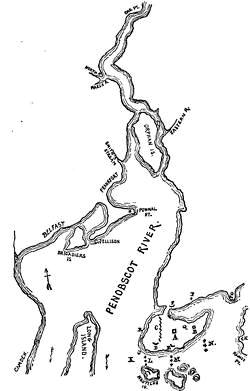
SIEGE OF PENOBSCOT, 1779.
Lovell's troops and the seamen struggled in disorder through the Maine wilderness, and the general himself reached Boston about Sept. 20th. A court of inquiry, under Gen. Artemas Ward, exonerated Lovell, and blamed Saltonstall. Nash prints its report, which is preserved in the Mass. Archives, vol. cxiv. It is examined by Eben Hazard in a letter printed in the Mass. Hist. Soc. Proc., iv. 129, in which he intimates that the blame was not all the naval commander's, and that it was a part of the plan to throw the responsibility on a Continental officer, in order to force the cost of the expedition upon Congress.
The annexed sketch is a combination of the two maps on a much larger scale in Calef's Siege of Penobscot (London, 1781). On the approach of the American fleet up the river, the British garrison was encamped on the peninsula of Maja-big-waduce (the modern Castine) at Q, and their main fortification, Fort George (A), was not completed. Capt. Mowatt, the naval commander, placed his three vessels in line (L) to defend the harbor. The Americans were first seen July 24th. On the 25th the American transports passed up the river and anchored, while nine armed ships in three divisions at K attacked the British ships at L; the American land forces, meanwhile, attempting to land at R, were repulsed. On the 26th, towards night, the Americans placed some heavy guns on Nautilus Island, whereupon the British ships moved back to a position at M. On the 27th the American ships engaged the British battery D with little result. On the 28th the Americans succeeded in landing at R, captured the battery D, and established the lines C. The battery on Nautilus Island disturbing the ships at M, they moved farther up to N. On the 29th the Americans opened their batteries along the lines C, and the British moved some guns from the half-moon E to the fort, and the ships sent ashore some cannon to be mounted at E. On the 31st the American seamen and marines attempted a landing between D and E, but were repulsed. On August 4th the Americans opened a battery at G, annoying the ships at N, and endangering their communications with the forts. The American batteries at F and H were not completed, and the one at H was abandoned on August 9th. On August 5th the British naval commander began the battery B to protect his communications with the fort; and while building it, the Americans planted, on the 8th, a field-piece at F to annoy the men working.
On the 13th arrangements were making for a vigorous attack, when the reinforcing British fleet appeared in the offing. During the night the Americans reëmbarked, and all their vessels fled up the river. Only the "Hunter" and "Hampden" attempted to escape down the river, and these were captured. Night coming on, the British anchored; while the Americans landed their men, and then blew up their vessels. The commodore's ship, "Warren", of thirty-two guns, was burned at Oak Point.
Calef's map is given in Wheeler's Pentagoet. A MS. plan of the operations of the English fleet is among the Faden maps (no. 101), in the library of Congress. As a result of their success at Penobscot, the British government, the next year, attempted to erect Maine into a province under the name of New Ireland (Bancroft, x. 368; Barry's Mass.; Me. Hist. Soc. Coll., vii. 201).