Chapter V · (continued 2)
Reading edition
EDITORIAL NOTES ON THE SOURCES OF INFORMATION.
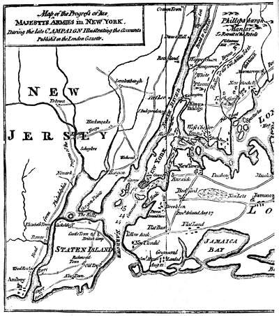
During the movements of Washington to check the British in their attempts to secure New York, what Congress called a flying camp was formed of some militia in Jersey, under Mercer, to impede the enemy's advance in case he turned towards Philadelphia.[888]
In Nov., 1776, Washington, crossing into New Jersey,[889] left Lee in command on the New York side, but Washington, at first requesting, afterwards instructed Lee to follow him (Sparks's Washington, iv. 168, 186-7, 193; 5 Force, iii. 779; N. Y. Hist. Soc. Coll., 1872, p. 267). Lee's secret purpose was to find some excuse for delaying, and so to prolong his independent command, with a chance of making a brilliant stroke. He endeavored at first to quiet Washington's importunities by detaching a part of Heath's force at Peekskill, but Heath would take orders only from Washington (Memoirs).[890] Finally Lee was moved to follow (Dec. 2d and 3d), and while crossing Jersey "to reconquer it" he was surprised at his transient quarters, Dec. 13, 1776, and captured. Captain Bradford, Lee's aid, gave Stiles the account which is entered in his diary (Johnston's Campaign of 1776, Docs., p. 146, and N. E. Hist. and Geneal. Reg., 1860, p. 33).[891]
(From the Gentleman's Magazine.)
We have abundant evidence of the consternation which ensued in Philadelphia upon the advance of the British to Trenton.[892] The political condition of the government of the colony was very unstable. The colonial charter, under the instigation of Congress (May 10, 1776), had been overthrown by a convention called in the interests of the patriot party, which in July had met to frame a new constitution.[893] This, however, upon its adoption, failed of being effective, by its opponents' obstructive movements to prevent the organization of an executive council, so that in the interim the supreme power, such as it was, resided in a Council of Safety, which was hampered in its control of the militia. Such was the conjunction when fear of an invasion came, and the Quaker element was passive under the alarm, and, indeed, antagonistic to measures of resistance.[894]
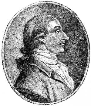
JOS. REED.
From Du Simitière's Thirteen Portraits (Lond., 1783). Cf. also Heads of illustrious Americans (London, 1783). A likeness by C. W. Peale, engraved by Sartain, is in W. B. Reed's Life of Jos. Reed, vol. i. A copy of the original painting is in the Hist. Society of Penna. There is also the profile likeness in 2 Penna. Archives, xi.; Scharf and Westcott's Philadelphia, i. 279. There is a painting in Independence Hall by C. W. Peale, which differs from that engraved by Sartain.
The Jersey campaign in general can be followed in original authorities in Sparks's Washington, vol. iv.; Force's 5 Amer. Archives, iii.; in Joseph Reed's "Narrative of the movements of the American army in the neighborhood of Trenton in the winter of 1776-1777", which, having been used in Reed's Reed, i. ch. 14, is printed in the Penna. Mag. of Hist., Dec., 1884, p. 391; the account by Congress,—not very correct,—dated Baltimore, Jan. 9, 1777, and sent to France (Lee's R. H. Lee, and E. E. Hale's Franklin in France, 97); and the current reports sent from Boston, Feb. 27, by Bowdoin to Franklin (Hale, p. 110.)[895]
The principal British contemporary accounts are in Stedman, Annual Register, Howe's Narrative, the evidence of Cornwallis in the Detail and Conduct of the War, and Letter to a Nobleman, 1779.
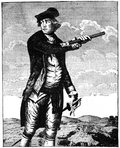
CHARLES LEE.
From An Impartial Hist. of the War in America, Lond., 1780, p. 319, where the print represents his full length. Compare with this a print by Thomlinson, published in London, Oct. 31, 1755, with cannon and a flag bearing the motto "Appeal to Heaven", which is reproduced in Smith's British Mezzotint Portraits, and the engraving by G. R. Hall in Moore's Treason of Charles Lee, and in the quarto edition of Irving's Washington. There is a German print in the Geschichte der Kriege in und ausser Europa (Nürnberg, 1778).
Dr. Moore considers the only picture of Lee which "bears any evidence of authenticity, or answers to the descriptions given by his contemporary friends and biographers", to be one drawn by Barham Rushbrooke at the time of Lee's return from Poland, and showing him dressed in the uniform of an aid of King Stanislaus. It was first engraved in 1813 in Dr. Thomas Gridlestone's treatise to prove that Lee was Junius, and that writer said of it that, "though designed as a caricature, it was allowed, by all who knew General Lee, to be the only successful delineation of his countenance or person." It is familiar in prints, representing his extremely attenuated figure in profile, with a small dog in front of him. It is given in Moore's Treason of Lee; Gay's Pop. Hist. U. S., iii. 460; in Scull's Evelyns in America (p. 295,—also see p. 196); and in K. M. Rowland's "Virginia Cavaliers" in the Southern Bivouac, April, 1886.
There are views of Lee's house in Virginia in J. E. Cooke's "Historic houses in the Shenandoah", in Appleton's Journal, p. 69, July 19, 1873, and in Mrs. Lamb's Homes of America.
The principal sources of Lee's history are: Edward Langworthy's Memoirs of the Life of the late Charles Lee, to which are added his Political and Military Essays (London, 1792; Dublin, 1792; New York, 1792, 1793). It was reproduced as Life and Memoirs of Maj.-Gen. Charles Lee (N. Y., 1795, 1813), as Political and Military Essays, with Memoirs, etc., 2d ed., with App. (London, 1797), and with new title as Anecdotes of the late Charles Lee, Esq. (London, 1797). Cf. Sparks's Life of Charles Lee (1846); Moore's Treason of Lee; the Papers of Charles Lee, published by the N. Y. Hist. Soc. in their collections; Irving's Washington, i. 377; Fonblanque's Burgoyne, 160; Jones's N. Y. during the Rev., ii. ch. 23; John Bernard's Retrospections of America (1887), p. 96.
On the temporary clothing of Washington with dictatorial powers, see the Circular of Congress (Dec. 28th), explaining why it was done (Journals, i. 585). Cf. also Sparks's Washington, iv. 550; Greene's Greene, i. 292; Thacher's Military Journal, 74; Wells's Sam. Adams, ii. 458, and the adverse views of Abraham Clark in N. Jersey Rev. Corresp., p. 68.
The purpose of some sudden stroke on Washington's part is well indicated.[898] The advance of Griffin with militia was opportune in drawing Donop forward to Mount Holly, so that he was too distant to support Rahl at Trenton.
On the attack on Trenton there is special record from the Washington papers in Sparks (iv. 242, 246, 541), Dawson, i. 20 (to Congress), Mass. Soc. Hist. Col., xliv. 32 (to Heath, and Heath's letter in N. H. State Papers, viii. 445). Others are in 5 Force, iii., a full record of the battle. Congress wrote to the agents in France (Diplom. Corresp., i. 246.)[899]
What is known as the Reed-Cadwalader controversy, hinging upon the alleged weakness or defection of Joseph Reed at this time, is more particularly examined in another place.
On the English side we have Howe's despatch in Dawson (i. 202) Tryon to Germain in N. Y. Col. Doc. (viii. 694). The effect of the battle in England to discourage the expatriated loyalists is told in Hutchinson's Diary, ii. 139. Stedman accuses Howe of bad judgment in placing so unfit a man in command as Rahl. Adolphus (ii. 385), On "private information" supposed to have been Arnold's, says that Arnold suggested to Washington the movement, and Mahon (vi. 130) has followed Adolphus.
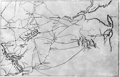
TRENTON, PRINCETON, MONMOUTH.
From the map in Marshall's Atlas to his Washington (1804). Cf. also Sparks's Washington, iv. 258; Guizot's Atlas to his Washington. The plans of Trenton and Princeton in Carrington (pp. 270, 302) vary somewhat from the contemporary ones as to roads. The chief contemporary English map of New Jersey is one based on the surveys of Bernard Ratzer in 1769, which was published in London, Dec. 1, 1777, by William Faden, and called The Province of New Jersey, divided into East and West, commonly called the Jerseys (32 × 23 inches). It was improved from surveys by Gerard Banker. It was reissued in fac-simile by the Geological Survey of New Jersey in 1877, and this fac-simile is in W. S. Sharp's reprint of Smith's New Jersey, 1877. Another fac-simile was published in 1884. A second edition of the original was published in 1778, corrected by the British and Hessian engineers.
An American map of the campaign, by Erskine, is given in the illustrated ed. of Irving's Washington, ii. 430. There are English maps in the Gent. Mag., Sept., 1776, and in Stedman's American War. Gordon gives a map (vol. ii. 525). Cf. Lossing's Field-Book, vol. ii.
We have Hessian maps of some of the movements preceding Howe's evacuation of New Jersey in 1777, which are among the Faden MS. maps in the library of Congress, and bear the name of Wangenheim, a "lieutenant dans les chasseurs Hessois, 1777", namely: No. 75, "Plan de l'affaire de Westfield et du camp de Raway, 1777, Jan. 26, 27." No. 76, "Plan de notre camp à New Brunswick, le 12e Juin; notre marche le 14 à Middlebush; la situation du camp le 15e Juin, et celle de Gen. Washington à Boundbrook." No. 77, "Position de notre camp le 24 Juin, 1777, à Perth Amboy."
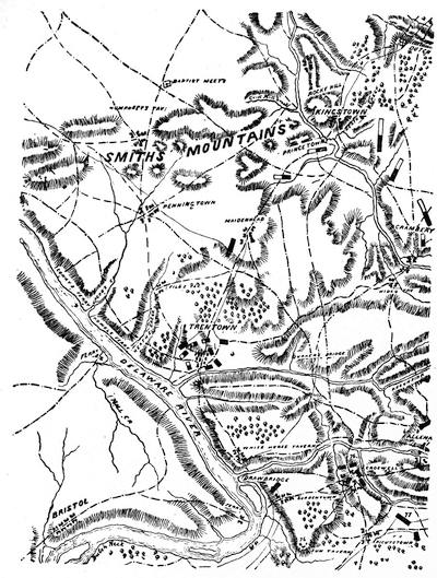
TRENTON AND PRINCETON.
A section of a large map in the library of Congress, apparently of Hessian origin, Plan général des opérations de l'armée Britannique contre les Rebelles, etc. The broken lines represent roads. The Americans are represented by blocks, half white and half black. The British are solid black. Key: "76, Marche du Général Cornwallis. 77, Marche du Général Knyphausen le 23 Juin, et son camp près de Richardstown."
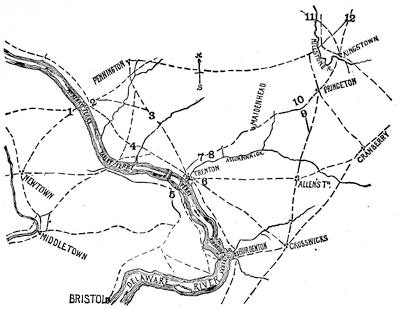
FADEN'S MAP OF TRENTON AND PRINCETON.
Sketched from a Plan of the Operations of General Washington against the king's troops in New Jersey, from the 26th of December, 1776, to the 3d January, 1777, by William Faden. London, 15th April, 1777. This map also makes part of the American Atlas, and the original MS. draft is among the Faden maps in the library of Congress. The map (the roads being represented by broken lines) bears legends to the following purport: Washington from his headquarters at Newtown moved his men on the evening of December 25th to 1, and by 4 o'clock on the morning of the 26th he had crossed to 2, where he divided his army into two divisions. The left, composed of 1,200 men with ten field-pieces under Greene, but accompanied by Washington himself, proceeded through 3 towards Trenton; the right, under Sullivan, consisting of 1,500 men with ten field-pieces, went through 4. Meanwhile "Erwin's" and Cadwallader's forces came to 5, hoping to cross the ferry, but the ice in the river prevented. At 8 o'clock on the morning of the 26th, Rahl at Trenton was surprised, and the entire force of Hessians with him were captured except 200 men, who, with some chasseurs and dragoons, escaped to "Burdenton", where they net Count Donop, who now, joined by these fugitives, proceeded with his command to Crosswicks, thence to Allenstown and Princeton. Washington, after his victory, encamped at 6, where he was reinforced by troops from Virginia, Maryland, and Pennsylvania. On January 2d the position was this: Washington had been confronted at 7 by the advance of Cornwallis at 8. The second brigade of the British under Leslie was at Maidenhead, and Lieutenant-Colonel Mawhood, with the 17th, 40th, and 55th British regiments, was on the road at 10,—all these troops having moved forward from Princeton after Washington's attack at Trenton. During the night of January 2d, Washington having withdrawn his detachments over the bridge, left fires along the southern bank of the Assumpink Creek to deceive the British, and marched from his camp at 6 to Allenstown, then turned towards Princeton, but his force in part left the road, and by the dotted line proceeded to 9, and on the morning of Jan. 3d attacked Mawhood at 10. Of the three British regiments here, the 17th was driven upon Leslie at Maidenhead, while the 40th and 55th retreated through Princeton and Kingstown towards Brunswick, beyond 12. Washington followed them to Kingstown and encamped there on Jan. 3, after having broken down the bridge over the Millstone to interfere with Cornwallis's overtaking him. On Jan. 4 Washington took the road through 11 to the passes in the hills, while Cornwallis, reaching Kingstown the same day, proceeded through 12 towards Brunswick.
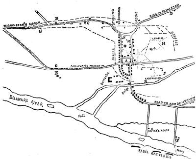
TRENTON.
Wiederhold's plan from the archives at Marburg, sketched from a fac-simile furnished by Mr. E. J. Lowell. (Cf. his Hessians, 92.) A marks the centre of the village. The Hessian outposts were at B, one officer and 24 men; C, Captain Altenbocum's company of the Lossberg regiment, quartered in the neighborhood, which formed in front of the captain's quarters, while the picket at B occupied the enemy; D, one captain, one officer, and 75 men; E, one officer and 50 Jägers, who retreated over the bridge on Sullivan's approach; F, one officer and 30 men, who joined Donop over the Bordentown road. The two columns of Washington and Sullivan emerged from the woods at G G. The broken lines (— — — —) indicate their line of march and successive positions, till they surrounded the Hessians. The beginning of the dotted lines (. . . . .) in the village shows where the Hessians attempted to form; but Rahl and Lossberg were driven back to H, and Knyphausen to J, and surrounded they surrendered. Knyphausen endeavored to reach the bridge, having with him the Lossberg cannon, which got stuck in the marsh at K, and the delay in extricating them was sufficient for Sullivan to occupy the bridge and cut off Knyphausen's retreat. His own cannon were at M, and were not used. Rahl's cannon were at N, and early dismounted. The Americans used cannon at s s s, etc. There is also among the Rochambeau maps (no. 18) a map done in faint colors, with an elaborate key, which is marked Engagement de Trenton, by Wiederhold, measuring about eight inches wide by ten high. A French plan is given in Mag. of Amer. Hist., 1880, p. 369. Cf. map in Raum's Trenton; Lossing's Field-Book, ii. 228 (with Rahl's headquarters, p. 228, and a view, p. 222). Carrington's special map of Trenton (p. 278) gives more detail than the contemporary plans.
Bancroft (ix. 217; cf. Irving, ii. 466) notes the Hessian journals which he had used.[900]
The affair at Princeton has special treatment in the Washington papers (Sparks, iv. 259; Dawson, i. 204), and is necessarily covered by the general historians.[901] On the English side Howe's letter (Jan. 5, 1777) to Germain is the principal source, and it will be found in Gent. Mag., Feb., 1777; C. C. Haven's Thirty days, 60; Dawson, i. 210. Cf. Mahon, vi. 132.[902]
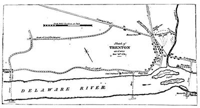
FROM WILKINSON'S ATLAS.
Sullivan delayed at F to give Washington a chance to make his longer detour by A before he (Sullivan) advanced by D. Washington attacked at B, and threw out riflemen at G and H. Rahl, deserted by a part of his force, who fled to Donop at Bordentown, surrendered at I, when he became aware of Sullivan's approach behind him.
Wilkinson also gives a map showing the movements between Dec. 25, 1776, and Jan. 3, 1777, and this is the basis of the map in C. C. Haven's New Historic Manual concerning the battles of Trenton and Princeton (Trenton, 1871).
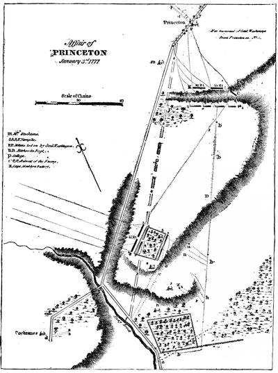
FROM WILKINSON'S ATLAS.
The advance, with which Wilkinson was, came by G to the vicinity of the wood A and Quaker meeting-house B. The main column turned off and followed the line b. Gen. Mercer proceeded to f. A detachment of the British at d, with officers reconnoitring at a a, discovered the American line on the route h; but coming to g, they also discovered Mercer at f, who wheeled by the line c, and gaining the orchard of Wm. Clark's house (5) confronted at 1—2 the British detachment now formed at 3—4. The Americans retreated when the British advanced to the slope (o o o), where they saw Moulder's battery, X, near Thomas Clark's house (7), which Washington had sent from his main line at h, together with other troops by the line r r, which induced the British to retreat on the line e e, while Mawhood, their commander, fled with a few infantry by the line, s s. At this juncture another British regiment, which had advanced from Princeton to C, fell back, and joining other troops took post at K and C, where they confronted Washington's main body, which now deployed at i i; and as the Americans attacked, the British fled to the college building (P), and then beyond by the route t t. Cf. plan in Lossing's Field-Book, ii. 235. Carrington's plan of Princeton (p. 278) gives further details from later study.
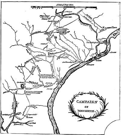
CAMPAIGN OF 1777.
A map in Captain Hall's Hist. of the Civil War in America (London, 1780), vol. i.
Howe's campaign of 1777 was the ruin of his military reputation.[903] Jones, in his severe criticism upon Howe, unjustly charges Galloway with making the suggestion of the expedition to the Head of Elk.[904] It is certain that Galloway threw himself upon Howe's protection not far from the time when Howe committed himself to a plan of capturing Philadelphia. About the same time it has been charged that General Lee, by a treasonable project, aided Howe's purposes in the same direction.
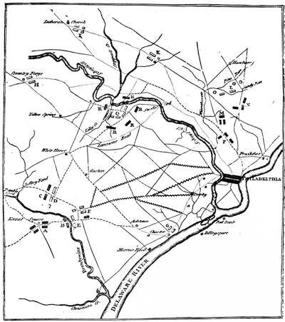
CAMPAIGN OF 1777.
From Galloway's Letters to a Nobleman, London, 1779. Key: A, the British army before the battle of Brandywine. B, Gen. Knyphausen's advance to the attack. C, Lord Cornwallis having turned the right wing of the rebel army. D, Sullivan advanced to oppose him. E, position of the rebel army. F, General Howe's quarters, in which he remained five days after the rebel defeat. a a a, Washington's retreat to Chester and Philadelphia. G, his camp at Chester, where he remained fourteen hours after the battle. The roads with the zigzag mark show those by which the rebels might have been intercepted after the battle. H, Washington's flight after the skirmish at Goshen. I, Washington's retreat when Sir Wm. Howe crossed the Schuylkill. K, Washington's camp, whence he marched to surprise the British army at Germantown, and to which he retreated after the battle. L, Washington's camp at Whitemarsh. (For his headquarters see Lossing's Field-Book, ii. 321, and his Mary and Martha Washington, p. 162.) M, the first position of the British. N, the second. O, O, O, where Washington's camp might have been attacked with advantage. P, British camp at Germantown. The line ——— denotes marches of the British army; the line of dots . . . . . . . . the marches of the rebel army. Q, Washington's lines at Valley Forge in the winter 1777. R, R, R, R, R, positions which might have been taken to besiege or assault the rebel quarters. S, the bridge. This map is also reproduced in The Evelyns in America, p. 252.
The principal contemporary engraved maps of this part of the country were the 1770 edition of Scull's Map of Pennsylvania (see Vol. V. p. 240), which was at this time included in the American Atlas (London, 1776), and the Atlas Amériquain (Paris, 1777), and Pownall's edition, 1776, of Evans's Map of the Middle Colonies (see Vol. V. p. 85), as well as Jefferys' edition, 1775, of the same, not so accurate. To these might be added Montresor's Province of New York and Pennsylvania, 1777; Mellish and Tanner's Seat of War in America; Faden's map of July 1, 1778, given in fac-simile in the Penna. Mag. of Hist., i. 285; the maps in the Gentleman's Mag., 1776 and 1777; Almon's Seat of War in New York, New Jersey and Pennsylvania, 1777. A modern map, covering the same field to illustrate the campaign, is given in Theodore W. Bean's Washington at Valley Forge one hundred years ago, and is repeated, with a few changes, in Proceedings at the Dedication of the Paoli Monument (Westchester, 1877). The contemporary French maps are Du Chesnoy's Théâtre de la Guerre, 1775-1778, Beaurain's Carte pour servir à l'intelligence de la guerre (Paris, 1777), Brion de la Tour's Théâtre de la Guerre (Paris, 1777), with another by Phelippeaux "pour servir de suite", and Bourgoin's Théâtre de la Guerre (Paris). There is a German map in the Geschichte der Kriege in und ausser Europa. There is in the Maryland Hist. Soc. library a map of stage routes between Baltimore and New York, showing the operations of the British from Elk River (1777) to Neversink (1778). (Lewis Mayer's Catal. of MSS. etc., in Maryland Hist. Soc., 1854.)
Cf. also the maps in Sparks's Washington, v. 66; Moore's Diary of the Revolution, orig. ed., 495; Penna. Archives, 2d ser. vol. iii.; Moorsom's Fifty-second Regiment; Hamilton's Coldstream Guards; Carrington's Battles, p. 398.
George H. Moore laid before the N. Y. Hist. Soc., in June, 1859, the document in Lee's handwriting, dated March 29, 1777, while he was a prisoner in New York, in which he sketches a plan for Howe's guidance in the coming campaign. The "plan" in fac-simile, together with an elucidation of it, was printed in Moore's Treason of Charles Lee, New York, 1860. The "plan" is also in N. Y. Hist. Soc. Coll., 1872, p. 361. Lee was at that time trying to induce Congress to send commissioners to New York to confer with him (Bancroft, ix. ch. 19), but Congress was not ensnared. Moore contends (p. 84) that the "plan" is responsible for Howe turning towards Philadelphia, instead of going north to help Burgoyne. Bancroft (ix. 333; also see p. 211) asserts that it could have had no influence on Howe's movements.[905]
Lecky quotes Galloway's testimony, that of the 66,000 men voted by Congress for this campaign, hardly 16,000 were in the field. Bancroft admits that no one better than Marshall (iii. ch. 3) has described the part of Washington in this campaign.[906]
At the opening of the campaign Washington was kept long in suspense as to the purpose of Howe. The eastern people feared his object was Boston.[907] Alexander Hamilton early in the season had become Washington's aide, and his letters at once begin to contain speculations on Howe's purpose (Works, Lodge's ed., vii. 481, 496, 500). On May 28th, Washington moved his headquarters from Morristown[908] to Middlebrook, and it was thought Howe would attempt to march direct for Philadelphia. On June 12th, Sullivan writes to Weare that Howe was to be confronted the next day (N. H. State Papers, viii. 584); and when it was known that Howe was retiring towards New York, Washington, June 23d, little credited a report, then prevalent, that the British army was panic-struck (Mass. Hist. Soc. Coll., vii. 138).[909] Cf., for all these movements, Montresor's Journal.
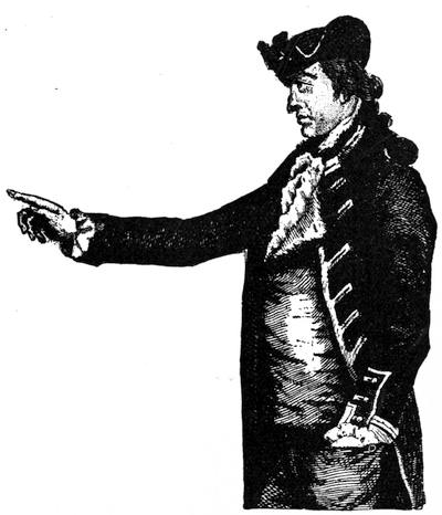
GENERAL HOWE.
From The Impartial Hist. of the War in America.
In July, when news came of the fall of Ticonderoga, there were no signs that Howe was preparing to coöperate with Burgoyne, and Hamilton wondered (Works, vii. 507, 515). When Howe sailed from New York, Washington was in suspense.[910] On July 31st, it was learned that Howe's fleet was at the capes of Delaware, and the next day the vessels had disappeared.[911] It was now supposed that Howe had gone to Charleston, S. C., and that Washington might safely reinforce the Northern army (Hamilton's Works, vii. 517). Lafayette first took his seat at a council of war called to consider the propriety of this (Sparks's Washington, v. 445).
In August, 1777, Gen. Sullivan conducted a raid into Staten Island to seize Tories. He captured some papers which implicated the Philadelphia Quakers in inimical movements. (Cf. Journals of Congress, ii. 246, 253.) In other respects the incursion was unfortunate, and his movements were examined by a court of inquiry, which acquitted him.[912]
Howe had been six weeks at sea, with three weeks' provisions, when he landed at the Head of Elk.[913]
Upon Washington's march to confront Howe, see, for the preliminary movements, William J. Buck's paper on "Washington's Head Quarters on the Neshaminy", in the Penna. Mag. Hist., i. 275.[914]
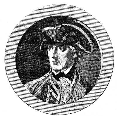
GENERAL SIR WILLIAM HOWE.
From Andrews's Hist. of the War, London, 1785, vol. i. It is reëngraved in Gay's Pop. Hist. U.S., iii. 412. Cf. engraving in Irving's Washington, illus. ed., New York, 1857, ii. Sargent gives a clever presentation of the character of Howe in his André, p. 136.
Upon the battle on the Brandywine the main American source is the letters of Washington. With Washington's aid, R. H. Harrison wrote to Congress from Chad's Ford, Sept. 11th, at 5 P. M., a letter which was at once circulated in broadside (Sabin, iii. p. 463; Hildeburn, no. 3,533). Pickering drafted for the commander-in-chief the report (Life of T. Pickering, i. 157) written at Chester, at midnight, September 11th (Sparks, i. 251; v. 58; Dawson, i. 278). Hamilton was on Washington's staff (J. C. Hamilton's Life of Hamilton). C. C. Pinckney, also on the staff, wrote a letter in 1820 (Hist. Mag., July, 1866, x. 202). Marshall, as a participant, drew somewhat upon personal experience in his account in the Life of Washington. Lafayette's narrative, as given to Sparks, is in the Sparks MSS. (no. xxxii. Cf. also Lafayette's Mémoires). There is a journal of Capt. William Beatty, of the Maryland line, in the Hist. Mag., 2d. ser., i. 79. Sparks examines some of the disputed points of the battle.[915]
There are contemporary records and opinions in the Penna. Archives, 2d ser., x. 316; the letter of the N. H. delegates in Congress in N. H. State Papers, viii. 678; current reports in Moore's Diary, 495; gossip in Adams's Familiar Letters, 296, etc.; Knox's account (Sept. 13th) in Drake's Knox, 48.[916]
On the British side, we find Howe's report, Oct. 10th, to Germain in Almon, v. 409; Dawson, i. 281. Cf. the evidence before Parliament in the Conduct of the War and the narrative in Stedman.[917]
The Hessian participancy is examined in Lowell's Hessians, 197. Bancroft quotes Ewald's Beyspiele grosser Helden as the testimony of an eye-witness of Washington's well-conducted retreat.[918]
A portion of the British troops used breech-loaders.[919]
The movements of the opposing armies toward Philadelphia can be followed in the main in the authorities cited for the battle. Some local details are in Pennypacker's Phœnixville, and an account of the damage done by the British on the march is in Smith's Delaware County (p. 544).
For the Paoli attack, we have Wayne's defence at the court-martial in Dawson, i. 315, and in the One hundredth anniversary of the Paoli massacre, p. 52, which last contains also, beside sundry contemporary records, the addresses of J. S. Futhey (also in Penna. Mag. Hist., i. 285) and Wayne McVeagh. The report of Howe to Germain is in Dawson, i. 317.[920]
On Sept. 26th, Washington described the state of the army, then at Potsgrove (Mag. Amer. Hist., Nov., 1884, p. 461). He was foiled by a rain in an effort to hold the British once more at bay, and Howe entered Philadelphia.[921]
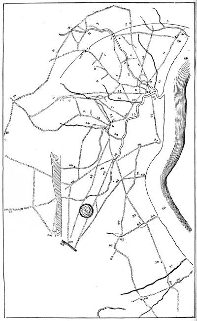
Note to the Opposite Map.—Washington's map of the Brandywine campaign, on the opposite page, is reduced from a tracing of the original in the possession of the Pennsylvania Historical Society. The legends upon it in Washington's handwriting are noted in the following key by letters, while those of the surveyor are given by figures. At one end of the map is the following inscription: "Laid down at 200 ps in an Inch, the 27th day of August, An. Domi 1777. Pr Jais. Broom, Survr. N. Castle Coy." At the other end is the following table:—
"m. q. ps.
From Chester County to Brandywine 7 0 21
From Brandywine to New Castle 6 1 19
From New Castle to Red Lyon 7 1 0
From Red Lyon to St. George 3 2 46
From St. George to Cantwell's Bridge 7 0 60
From Cantwell's to Blackbird 5 2 70
— — —
37 0 56
From Chester County to Brandywine 7 0 21
From Brandywine to Newport 4 0 79
From Newport to Bridgetown 5 0 12
From Bridgetown to Red Lyon 4 0 19
From Red Lyon to Harris Inn 5 2 51
From Harris Inn to Witherspoon's 6 1 44
From Witherspoon's to Blackbird 6 1 42
— — —
38 3 28
From New Castle to Christiana Bridge 4 3 45 "
Key: A, Chandler Ford, very good, but very broken ground and narrow defiles on the Et. side. B, Fording place by Thomas Gibson's. C, To Gibson's Ford. D, Road leading to Kennet's Square. E, Road leading towards Red Clay Creek. F, Hendrickson's Tavern. G, Richland fording place. H, Tavern. I, Smith's Store. J, James Walker. K, Mill Town. L, Rising Sun Tavern.
1, The Bottom Road, passing Brandywine at Chad's Ford (18). 2, Newlin's. 3, The line dividing the counties of Chester and Newcastle. [This is the curved northern boundary of Delaware.] 4, Gibson's Mill. 5, Gibson's Ford. The Center Road [runs to F]. 6, Kennet Meeting-house. 7, Clark's Inn. 8 [to 7 and beyond], The Road leading from Wilmington to Kennet's. 9, Naaman's Creek. 10, Grubb's Inn. Grubb's Road [leads from 10 to 5]. 11, The Road leading from Wilmington to Chester. 12, Shelpot Creek. 13, Foulk's Road. 14, The Concord Road. 15, Brandywine Creek. This creek, except the fording place, impassable. 16, Bridge. 17, M'Kim's [?] Mill. 18, Chad's Ford. 19, 20, Delaware River. 21, Wm. Miller's Mill. 22, Red Clay Creek. 23, Christiana River. 24, The Borough of Wilmington. 25, The Road leading from Wilmington towards Lancaster. 26, Mill Creek. 27, Bridge. 28, The Road leading from Wilmington to Newcastle. 29, Ferry. 30, Newport. 31, The Road leading from Newport towards Lancaster with bridge at 32. 33, The Lancaster Road. 34, Mill creek. 35, Bridge. 36 [to 46], White Clay Creek. 37, New Castle. 38, The Road leading from N. Castle to Christiana Bridge. 39, Bridge [Christiana]. 40, Hamburgh. 41, [The Road] to the Red Lyon. 42, The Road leading from New Castle to the Elk River. 43, The Road leading from Christiana Bridge to Elk River. 44, Ogle Town. 45, The Road leading from Ogletown to the Head of Elk. 46, Mill of Capt. Black's. 47, 48, [Shaded space showing where the original is worn through]. 49, Newark. 50, The Road to Johnson Ferry on Susquehanna. 51, [Road to Nottingham]. 52, Iron Hill. 53, The Road leading from Red Lyon to Black Bird Creek. 54, St. George's Creek. 55, Mill Pond. 56, Trap [?] 57, Drawyer's Creek. 58, Appoquinimink Creek. 59, Cantwell's Bridge. 60, Witherspoon's. 61, Part of Bohemia. 62, The upper Road leading from Red Lyon to Blackbird Creek. 63, Clemon Mill. 64, Elk. 65, Part of Elk River. 66, Joseph Gilpin's. 67, Harris Inn. 68, The Road leading towards Bohemia.
Sullivan, with the charge of inefficiency for Brandywine still hanging over him, was the first to encounter the outposts of the British at Chestnut Hill, when he opened the day of Germantown. His letter (Oct. 25th) addressed to the president of New Hampshire was first printed by Sparks.[922]
Washington's letters to Congress and others are of the first importance.[923]
In Timothy Pickering's Life (i. 166) there is an account of the battle from his journal, which sustains the positions taken by Pickering in 1826,—though he does not refer to it at that time,—in the controversy which was waged by him and Sparks with Johnson, the author of the Life of Greene.[924]
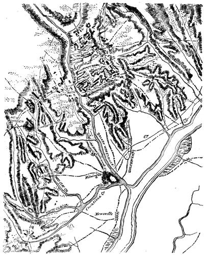
BRANDYWINE.
Sketched from a large MS. Hessian map in the library of Congress, Plan générale des opérations de l'armée Britannique contre les Rebelles, etc. Key: "19, Marche de l'armée pour New Gardens. 22, Marche du général Knyphausen pour Kennet Square, 9 Sept. 24, Camp que l'armée occupa aux environs de Kennet Square. 26, Marche du général Cornwallis vers le Brandywine. 30, Première position du Gen. Cornwallis. 31, 2me position de ce général. 32, Attaque de ce général. 33, Position des enemis. 34, Retraite des enemis. 38, Marche du corps detaché à Wilmington. 57, Marche du corps detaché à Wilmington pour Philadelphia le 16 Oct." The lines (·–·–) represent roads.
The published plans of Brandywine are the following: In the Examination of Joseph Galloway and letters on the Conduct of the war. In Sparks's Washington, v. 58. Cf. also Duer's Stirling, ii.; Irving's Washington, iii. 190. In Marshall's Washington, vol. v. Sketch by J. S. Bowen and J. S. Futhey in Penna. Hist. Soc. Bull., i. no. 7 (1846). In Penna. Archives, 2d ser., x. 316; Carrington's Battles, p. 382; Hamilton's Grenadier Guards, ii.; Lowell's Hessians, 198; Lossing's Field-Book, ii. 377 (with views of the ground, 378, 379).
There are among the Faden maps (nos. 78, 79) in the library of Congress a careful topographical drawing of the battle of Brandywine, and a corrected proof of the map as published by Faden in 1778. There are among the Faden maps (nos. 80, 80½) plans, by the Hessian Wangenheim, of the camp at Wilmington to cover the British hospitals after the fight at Brandywine, and a map of the positions of the army in the action of Sept. 19th, as well as Cornwallis's march in November to Philadelphia.
Of the writers near the event, Gordon drew from original sources; Marshall was an actor in the scenes; and there are accounts in Wilkinson, i. 353, 359, 361. G. W. P. Custis's Recollections, ch. 4, and the later writers need to be consulted.[925]
On the English side, Howe's despatch to Germain is in Dawson (i. 330). The letter of a British officer, dated Philadelphia, Oct. 19, 1777 (London Chronicle, Jan. 3-6, 1778), is reprinted in Penna. Mag. of Hist., April, 1887, p. 112.[926]
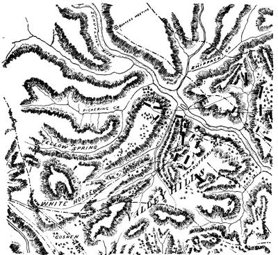
TRUDRUFFRIN, OR PAOLI.
Sketched from a portion of a MS. Hessian map in the library of Congress, called Plan générale des opérations de l'armée Britannique contre les Rebelles, etc. The lines ·–·– represent roads.
Key: "41, marche du général Knyphausen et son camp le 18me; 42, marche du général Cornwallis le même jour; 43, camp du corps près de Valley Forge; 44, corps des Rebelles surpris par le général Grey le 21me; 45, camp et marche du général Knyphausen le 21me; 46, marche de l'armée par le Schuylkill près de Valley Forge, et le camp qu'elle occupa le 23me près de Norris Town House." The British are shown in solid black blocks, the Americans in black and white.
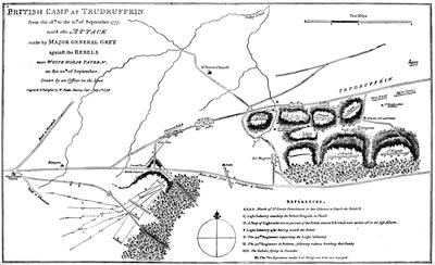
Note.—This map is a fac-simile from one of Faden's maps. There is among the copies of the Lafayette maps in the Sparks collection at Cornell University one of the British Camp at Trudruffrin, from the 13th to the 21st of September, with the attack made by Major-General Grey against the Rebels near White Horse tavern on the 20th of September. This is merely a transcript of the Faden map, of which there is a fac-simile in Penna. Mag. of Hist., i. 285. Cf. Penna. Archives, 2d ser., x. 316. The MS. of Faden's maps is among the Faden maps in the library of Congress (no. 81). There is a view of the Paoli monument in Scharf and Westcott's Philad., i. 349, and in Lossing's Field-Book, ii. 372.
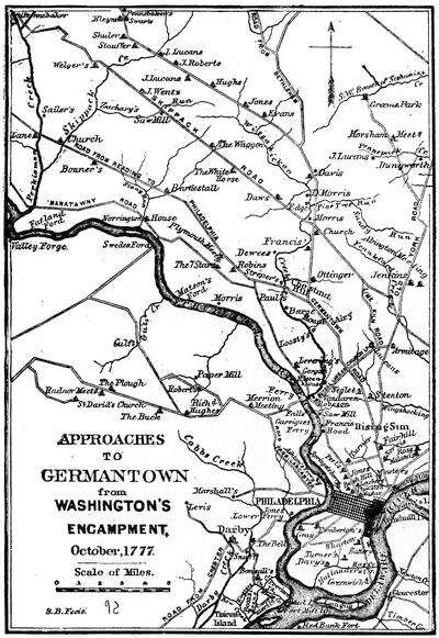
From Pennsylvania Archives (2d ser., vol. xi. p. 191).
Cf. the maps in Scharf and Westcott's Philadelphia, i. 353, and in Penna. Mag. of Hist., i. 375.
The seaward defence of Philadelphia depended on the forts Mercer and Mifflin, on the chevaux-de-frise in the river, and on the Pennsylvania navy. Howe's first attempt, in October, to get his shipping up to support his army failed.[927]
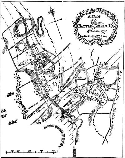
MONTRESOR'S PLAN OF GERMANTOWN.
Note.—This map is sketched after an original in Harvard College library. There is a duplicate, evidently made by the same hand, among the Peter Force maps, in the library of Congress. The map was engraved and published in London. There is a map published by Faden in London, March 12, 1784, which is not trustworthy, however, as to roads, which was called Sketch of the Surprise of Germantown by the American forces commanded by General Washington, Oct. 4, 1777, by J[ohn] Hills, Lt. 23d Reg.
Other published maps are the following: in Johnson's Greene, i. 80 (showing three stages); Sparks's Washington, v. 86 (also in Duer's Stirling, ii. 177; Irving's illustrated Washington, iii. 286; Guizot's Atlas); Carrington's Battles, 392; Lossing's Field-Book, ii. 314; Scharf and Westcott's Philad., i. 354; Penna. Archives, 2d ser., xi. 188; Penna. Mag. of Hist., i. 368.
For views of the Chew House, see Day's Hist. Coll. of Penna., 492; Scharf and Westcott's Philad., i. 356; Egle's Penna., 178; Lossing's Field-Book, ii. 514; Mag. of Amer. Hist. (March, 1880), iv. 192.
The following are the main portions of Howe's despatch to Lord George Germain, dated at Germantown, Oct. 10, 1777: "The enemy marched at six o'clock in the evening of the third from their camp near Skippach Creek, about sixteen miles from Germantown. This village forms one continued street for two miles, which the line of the encampment, in the position the army then occupied, crossed at right angles, near a mile from the head of it, where the second battalion of light infantry and the fortieth regiment were posted. At three o'clock in the morning of the fourth, the patrols discovered the enemy's approach, and the army was immediately ordered under arms. Soon after the break of day the enemy began their attack upon the second light infantry, which they sustained for a considerable time, supported by the fortieth regiment; but at length being overpowered by increasing numbers, the light infantry and a part of the fortieth retired into the village, when Lieutenant-Colonel Mulgrave with six companies of the latter corps threw themselves into a large stone house [Chew's], which, though surrounded by a brigade, and attacked by four pieces of cannon, he most gallantly defended, until Major-General Grey, at the head of three battalions of the third brigade, turning his front to the village, and Brigadier-General Agnew, who covered Major-General Grey's left with the fourth brigade, by a vigorous attack repulsed the enemy with great slaughter. The fifth and fifty-fifth regiments from the right, engaging them at the same on the other side of the village, completed the defeat of the enemy in this quarter. The regiments of Du Corps and Donop being formed to support the left of the fourth brigade and one battalion of the Hessian grenadiers in the rear of the Chasseurs, were not engaged. The precipitate flight of the enemy preventing the two first corps from entering into action, and the success of the Chasseurs in repelling all efforts against them on that side, did not call for the support of the latter. The first light infantry and the pickets of the line in front of the right wing were engaged soon after the attack began upon the head of the village. The pickets were obliged to fall back, but the light infantry, being well supported by the fourth regiment, sustained the enemy's attack with such determined bravery that they could not make the least impression on them.
"Two columns of the enemy were opposite to the guards, twenty-seventh and twenty-eighth regiments, who formed the right of the line. Major-General Grant, who was upon the right, moved up the forty-ninth regiment about the time that Major-General Grey had forced the enemy in the village, and then advancing with the right wing, the enemy's left gave way, and was pursued through a strong country between four and five miles.
"Lord Cornwallis, being early apprised, at Philadelphia, of the enemy's approach, put in motion the two battalions of the British and one of the Hessian grenadiers, with a squadron of dragoons, and his lordship getting to Germantown just as the enemy had been forced out of the village, he joined Major-General Grey, when, placing himself at the head of the troops, he followed the enemy eight miles on the Skippach road; but such was the expedition with which they fled, he was not able to overtake them. The grenadiers from Philadelphia, who, full of ardor, had run most of the way to Germantown, could not arrive in time to join in the action."
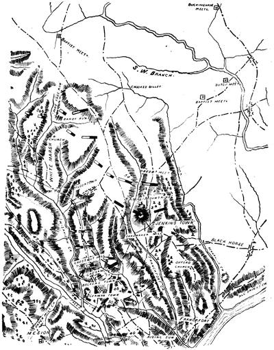
GERMANTOWN AND VICINITY.
Sketched from a part of a large map in the library of Congress, evidently of Hessian origin,—Plan générale des opérations de l'armée Britannique contre les Rebelles, etc. (August, 1776 to 1779). From the Renvoy the interpretation of the following numbers is taken: "40, marche du général Cornwallis le 16me; 47, marche du général de Knyphausen vers Germantown et le camp qu'il occupa le 23me près de ce village; 48, marche du général Cornwallis vers Germantown et son camp près de village; 50, campment de l'armée aux environs de Germantown; 51, emplacement des enemies et leur attaque; 52, la maison deffendue par le Colonel Musgrave avec un partie du 40me regiment; 54, retraite de l'enemie." The lines (·–·–) mark the roads.
The chevaux-de-frise at Billingsport was laid by Robert Whyte, who went subsequently over the enemy, and he is charged with placing it purposely in a defective manner. Wallace (p. 228, with plans, p. 134), who examines the evidence, seems to think the charge is proved. Respecting the share of the navy in the defence of the river, the principal sources are the minutes of the naval board, etc., in 2 Penna. Archives, vol. i., and other papers in iv. 748. An examination of this defence is made in Wallace, p. 130, etc.[928]
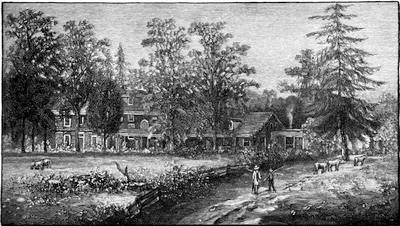
STENTON (JAMES LOGAN'S HOUSE).
This view of the house occupied by Howe and Washington as headquarters is taken from a painting in the Penna. Hist. Society. It is a rear view of the building. There is in the same collection a pen-and-ink sketch by Joseph Pennell. The position of the house can be seen in the map on another page, called "Approaches to Germantown." Howe occupied it at the time of the battle of Germantown. Cf. Scharf and Westcott, p. 871.
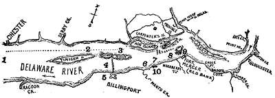
FADEN'S MAP OF THE OPERATIONS ON THE DELAWARE.
Sketched from an adaptation of Faden's Course of the Delaware river from Philadelphia to Chester, exhibiting the several works erected by the rebels to defend its passage, with the attacks made upon them by his majesty's land and sea forces, engraved by Wm. Faden, 1778, which is given in Wallace's Col. Wm. Bradford, p. 228.
Key: 1, Lord Howe in the "Eagle", with the "Apollo" and transports; 2, the "Camille" and "Zebra;" 3, the "Vigilant" and "Fury", which moved up by the dotted line to a position in the channel between Mud Island and Carpenter's Island, to attack Fort Mifflin, on Mud Island; 4, the "Experiment" and transports, below the "lower stackadoes" (shown by the zigzag line) through which there was a passage of seventeen feet near the fort at "Billingport", which was abandoned to Lt.-Col. Stirling, Oct. 1st; 5, camp on Nov. 18th; 6, wreck of "Merlin;" 7, the "Augusta" blown up; at these points (6 and 7) were the other British vessels, "Somerset", "Isis", "Roebuck", "Pearl", "Liverpool", "Cornwallis's galley",—some attacking Fort Mifflin, others engaging the American fleet at 8, others the battery of two 18-pounders and two 9-pounders at 10; the house of Tench Frances is between this battery and Manto Creek; 8, between the American fleet at this point and Mud Island is the "upper stackadoes" (shown by the zigzags); 9, the nearer of the two islands off Fort Mercer is Woodberry Island, and the other is Red Bank Island. These two islands have since disappeared. The rest of the American fleet was at this point. Beside the shore batteries on Carpenter's Island, there was a redoubt further inland, and another redoubt protected Webb's Ferry and the road to Philadelphia.
Upon the attack of Donop on Fort Mercer, at Red Bank (Oct. 22), the letter received by Washington from Major Ward, written at the desire of the commander of the fort, Col. Christopher Greene (cf. Greene's Nath. Greene, i. 489), is in Sparks's Washington, v. 112, and Dawson, i. 355, as is also Commodore Hazlewood's description of the naval part of the attack.[929]
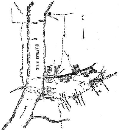
LAFAYETTE'S VICTORY NEAR GLOUCESTER, N.J.
This sketch follows a colored map among the Lafayette maps in the Sparks collection at Cornell University, entitled Carte de l'action de Gloucester entre un parti Américain, sous le Gl. Lafayette et un parti des Troupes de Lord Cornwallis, commandé par ce Gl. après son fourage dans le Jersey, le 25 9bre, 1777. While Lafayette's forces were at Haddonfield, the enemy at Gloucester were reconnoitred from Sand Point (1), and when the troops moved along the Haddonfield road the American riflemen (6), supported by the militia, attacked the Hessian outposts (9), when detachments were stationed on the cross-roads (7, 7) to protect the American right flank, while some chasseurs (8) threatened the Hessians' right flank. The enemy were driven back (10) till Cornwallis supported them with some English. They were still further pushed back till within a mile of Gloucester (11), when night closed the conflict. The legend on the map puts the English and Hessians (2, 3, 9) at 5,000 men, the boats (4) representing the withdrawal of part of them with their baggage across the river.
Lafayette's narrative, as given by him to Sparks, is in the Sparks MSS., no. xxxii.
Lafayette talked with Sparks of Donop (Sparks MSS., xxxii.). Knyphausen's report is in the archives at Marburg, and is used by Lowell (Hessians, 206). The despatches of the Howes are in Almon (v. 499), and Dawson (i. 356, 357).
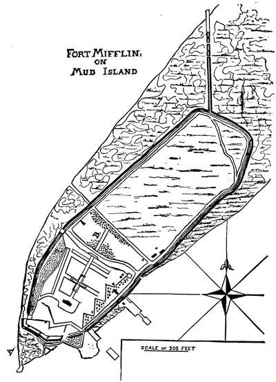
(From a large map in the library of Congress.)
Of the attack (Nov. 10-16) on Fort Mifflin (Mud Island) and its evacuation, with the opening of the river to the British fleet, the best garner of contemporary accounts with comment, is in Wallace's Bradford (p. 194, etc.), but some of this material is found also elsewhere.[930]
There has been some dispute over the respective claims of Col. Samuel Smith[931] and Commodore Hazlewood for the defence of the fort (Wallace, App. 10).
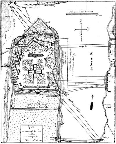
FLEURY'S PLAN OF FORT MIFFLIN.
Note.—The annexed plan is a fac-simile, somewhat reduced, of a pen-and-ink sketch among the Sparks maps in the library of Cornell University. It is endorsed "Maj. Fleury's Plan of Fort Mifflin", and it bears also on the back in the author's hand these words:
"The engineer author of this imperfect draugh begg endulgence for it; considering that he has not paper, pen, rule, neither circel, and being disturbed by good many shells or cannon balls flying in the fort. Lewis Fleur."
The reverse also bears an "Explanation" in French in Fleury's hand, and beneath an English translation in another hand, seemingly made at the time. This last is as follows:—
"Explanation—All marked A are new works. A 1, 2, 3. Traverses to defend the battery from ricochet shot. A 4, 5. Ditches to close the left of the battery, which was open. A 6. A double iron chain which encloses the right of the battery. A 7. Pits with sharp upright stakes to defend the approaches to our enclosure. A 8. Banquet raised round the wall. A 9. Ditches and parapet of reunion between our barracks, which will make a second inclosure and be furnished with loop-holes. A 10. Last retreat in the middle of the Fort, made when we had only 120 men in garrison. A 11. Demilunes to flank the front, substituted to [sic] the block house, which was blown up. A 12, 13, 14. Fraisework.
"15. Enemy's battery of 2 mortars. 16. [Ditto] 5 pieces large cannon, 1 mortar. 17. [Ditto] 2 pieces cannon, 1 mortar. 18. Unfinished Redoubt at a mile and a third from the fort, near the road. 19. A pretty extensive work at about the same distance. 20. Epaulements for the guards."
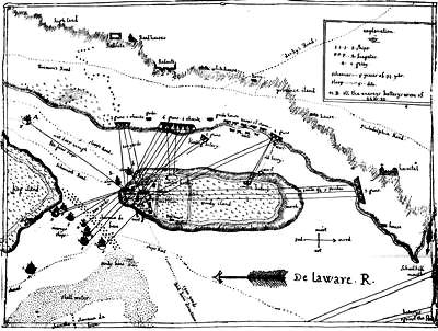
ATTACK ON FORT MIFFLIN.
Note.—This map is reduced in fac-simile from one of Fleury's pen-and-ink sketches among the Sparks maps at Cornell University. It is endorsed "Mudd Island", but not by Washington, as the Sparks Catalogue (p. 207) says. There are noted in the same catalogue (p. 207) two other pen-and-ink drafts of the fort and its vicinity, both apparently the work of Fleury, also. One is smaller, covering much the same ground as the present fac-simile except that it does not show the ships and Hog Island. It is entitled: "Figuré aproximatif de fort island et des ouvrages des assiégeans. 16 octobre, 1777." It has an "Explanation" in French on the reverse, accompanied by a statement that it had been scrawled on a gun-carriage, without compasses, rule, or scale, and under difficulties arising from the bursting of one bomb which carried away his inkstand, and of another which ploughed the ground where he sat.
The other plan is larger, and has been folded like a letter, and is addressed on the outside, "His Excellency General Washington, Headquarters." It shows only the west edge of Mud Island, but marks particularly the distance, range, and armament of the attacking batteries, and is called, "Figuré aproximatif des ouvrages des assiégeans 14 9bre, 1777." It marks the distance from the redoubt on the highland to Fort Mifflin as "1 mile 1-4 5 p." The wharf on the island is described as "où l'enemie déscendra, quoi que nous l'ayons detruite."
Other published maps of Mud Island (Fort Mifflin) are in Scharf and Westcott's Philadelphia, i. 363; Lossing's Field-Book, ii. 296; Wallace's William Bradford, p. 229.
Scharf and Westcott (p. 361) also give a plan made before the attack, by Col. Downman, of the British army.
Red Bank is particularly delineated in Smith's Delaware Co., 321; Penna. Archives, 2d ser., vol. v.; and Lossing, ii. 290, with views, etc.
On the British side we have the despatches of the Howes (Dawson, i. 364, 366), the journal of Montresor (Penna. Mag. of Hist., 1882, v. 393; vi. 34); the letters in Scull's Evelyns in America, 246, 253; and the account in Rivington's Gazette, cited by Wallace.
In addition to the references already made for the two attacks, the entire movements on the river are illustrated more generally in the letters of Washington, copied from the Penna. Archives, as well as in the diary of the Council of War in the Sparks MSS., no. 2. There are other contemporary accounts.[932]
Lafayette's attack on Gloucester soon followed. See plan on page 430.
The contrasts between the hilarities of the British in Philadelphia and the trials of the Americans at Valley Forge during the winter are abundantly illustrated.
The publication of the Penna. Evening Post was resumed in Philadelphia, Oct. 11, 1777, and continued during the British occupation of Philadelphia.[933]
Various diaries kept in and near Philadelphia have been preserved,[934] and the details of the life in the town have been worked up by modern writers.[935]
The complimentary festival given to General Howe on his departure, known as the Mischianza, took place May 18th, at the Wharton house.[936]
On the condition of Washington's camp at Valley Forge we have first the testimony of his own letters and those of his corespondents,[937] as well as that of sundry diaries and journals.[938]
The question of supplies as affecting the camp is considered in Stuart's Trumbull and Greene's Greene (ii. 48), this general being made quartermaster-general in March.
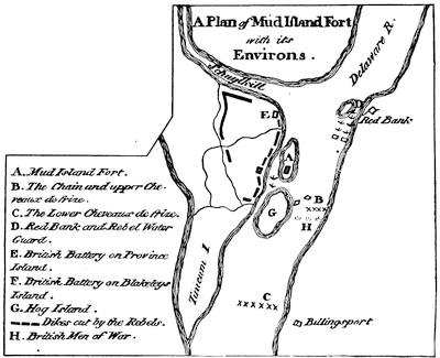
ATTACK ON MUD ISLAND.
From Galloway's Letters to a Nobleman, London, 1779. The leading published map of Delaware Bay and River at this time was one surveyed by Joshua Fisher, and published in London by Sayer and Bennett, 1775 and 1776. It was reproduced in Penna. Archives, 2d ser., vol. iii.; and maps based on them are in the Gent. Mag., July, 1779. There was a French edition issued in Paris by Le Rouge in 1777, which also made part of the Atlas Amériquain. Other charts are in the No. Amer. Pilot, 1776, and in the Neptune Américo-Septentrional, 1778.
There are plans for obstructing the river, in Penna. Archives, 2d ser., i. 749. Other maps of the river defences will be found in Sparks's Washington, v. 156; Irving's Washington (quarto), iii. 278; Smith's Delaware County, p. 321; Lossing's Field-Book, ii. 298; Carrington's Battles, p. 396.
There are preserved various orderly-books of the camp.[939]
There were efforts to reorganize the army during the winter. Congress had created a board of war in November, 1777 (Pickering, i. 187; Lossing, ii. 867). On Jan. 10, 1778, a committee of Congress was appointed to visit the camp and concert plans for the reorganization (Journals, ii. 401). A plan was drawn up by conference, and later adopted by Congress (Sparks, v. 525). Francis Dana wrote from the camp, Feb. 12th, to Congress, and the draft, found among the papers of Laurens, was printed in the Polit. Mag. (vol. i.,—1780), by which it was thought to appear that Howe could have destroyed the American army if he had had enterprise.[940]
A few days after the taking of Philadelphia, the Rev. Jacob Duché, of that city, who had been an approved supporter of the Americans, transmitted a letter to Washington, tempting him to desert the cause. Washington sent the letter to Congress; but Sparks could not find it in the Archives at Washington, and prints it from Rivington's Gazette (Corresp. of the Rev., i. 448). The letters which grew out of this act, including one of expostulation from Francis Hopkinson, the brother-in-law of Duché, and that of repentance sent to Washington by Duché in 1783, can be found in Sparks, v. 94, 476.[941]
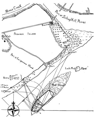
MUD ISLAND, 1777-1778.
Sketched from a corner map of the large MS. map, called on another page, "The Defences of Philadelphia, 1777-1778."
The military movements during the autumn of 1777 were mainly to try the temper of the opposing forces and to secure forage, and the incessant watching of each other's motions made Pickering write to Elbridge Gerry (Nov. 2d,—Mag. Amer. Hist., Nov., 1884, p. 461) that "since Brandywine we have been in a constant state of hurry."[942]
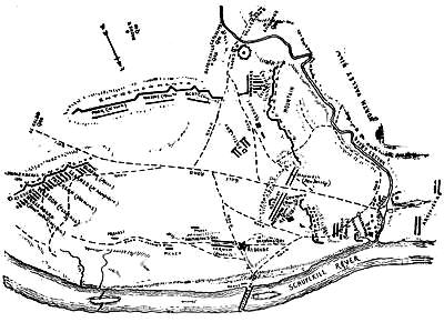
ENCAMPMENT AT VALLEY FORGE, 1777-1778.
A sketch made by combining two in the Sparks collection at Cornell University. One is a French plan, from the Lafayette maps, which gives the main features of the topography to the present sketch. The other is one transmitted by General Armstrong to Mr. Sparks in 1833, embodying the recollections of a Mr. William Davis, "a remarkably active and intelligent man, who resided within the limits of the camp during its continuance there." General Armstrong cites the testimony of a son of General Wayne, that the recollections of Davis "of the most minute occurrences of the period were entirety unaffected by age." Upon this dependence has been put for the positions of the troops and the quarters of the general officers. The plan given by Sparks (Washington, v. 196) seems to have been made by a similar combination, though he omits the locations of the general's quarters. The plan of Sparks is essentially followed in Guizot's Washington, in Lossing's Field-Book (vol. ii. 334,—also see Harper's Monthly, xii. 307), and in Carrington's Battles, p. 402 (and in Mag. of Amer. Hist., Feb., 1882).
There is a view of Washington's headquarters in Scharf and Westcott's Philadelphia, i. 369; Egle's Pennsylvania, p. 182; Lossing's Field-Book, ii. 332, and in his Mary and Martha Washington, p. 168; and Mag. Amer. Hist., Feb., 1882.
The French alliance was celebrated in camp May 6, 1778 (Sparks, v. 355; Moore's Diary, ii.).
For landmarks, etc., of Valley Forge, see Lossing's Field-Book; Read's Geo. Read (p. 326), from the Ohio State Journal; Harper's Mag., lx., 660, April, 1880.
At the centennial celebration, June, 1878, there were addresses by Henry Armitt Brown (in his Memoir and Orations, edited by J. M. Hoppin), and one by Theodore W. Bean, printed in the Daily Local News, Westchester, Pa., June 20, 1878.
During this time, Oct.-Dec., Washington was kept informed of the British movements through the letters of Maj. Clark (Penna. Hist. Soc. Bull., vol. i.). There was in November a project discussed of taking Philadelphia by storm (Drake's Knox, 136). Congress was urging the States to renewed efforts (N. H. State Papers, viii. 728). Early in December Howe had tried to allure Washington to a battle near Chestnut Hill or Whitemarsh (Sparks, v. 180; Dawson, i. ch. 31). By the middle of December the American army had gone into winter-quarters at Valley Forge (Reed's Reed, i. 345), but not without having thought at the same time of an attack on New York (Ibid., 344).
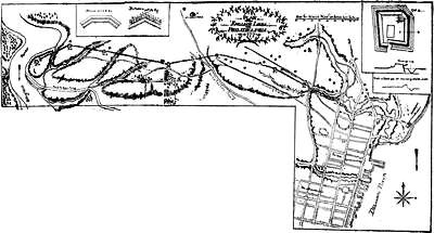
Note.—This plan of the British works between the Delaware and the Schuylkill is sketched from the main portion of a drawing preserved in the Penna. Hist. Society, which bears the following indorsement: "The redoubts in the English lines are ten, beside two advanced ones. No. 1, which I took a plan of in the month of July, was then compleat, but the excessive heat of the weather and many avocations prevented our prosecuting the survey till October, by which time the wooden work of the other redoubts, as well as the abaties, were carried away, which rendered it uncertain how many platforms there were in each, but from what traces remained [I] believe I am right in nos. 2 & ten: the other seven [eight] varied so little from no. 2, that the plan of that may serve for the rest: I am equally uncertain whether the abatis ran in direct lines from redoubt to redoubt or formed angles, but know that each part terminated at about 20 feet from the counter-scarps of contiguous redoubts, these intervals being occasionally stopped up by chevaux-de-frize. All the 10 redoubts were well faced both within and without with strong planks, but the advanced redoubts and other small pieces were only faced with fascines. On the right of the line where small streams run through swampy ground an inundation was formed by sloping the arches of the bridges, and making dams were necessary, each furnished with a tumbling dam, well planked on the top and slopes of the main dam, to carry off superfluous water.
Lewis Nicola."
Enlarged plans and cross-sections of redoubts nos. 1, 2, and 10 are given in the margin, as well as of the western advanced redoubt, and other small works, including the "Barriers across Kensington and Germantown roads with a cremaillered work between them cut out of the bank between the roads." The stars near the lines denote the places of "houses destroyed by the English." Cf. description in Penna. Mag. of Hist., iv. 181.
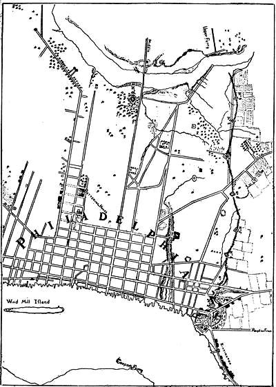
DEFENCES OF PHILADELPHIA, 1777-1778.
Sketched from a large MS. map by John Montresor in the library of Congress, dedicated to Sir William Howe, and called Plan of the City of Philadelphia and its environs, shewing the defences during the years 1777-1778, together with the Siege of Mud Island. A similar map by Montresor is among the King's maps in the British Museum (Catal., ii. 176).
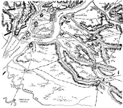
VICINITY OF PHILADELPHIA.
Sketched from a part of a MS. Hessian map in the library of Congress, called Plan générale des opérations de l'Armée Britannique contre les Rebelles, etc. The lines (·—·—) are roads. Key: "59, Attaque de mudden island le 15 Novembre. 60, Position du général Howe le 4 Dec. pour forcer le général Washington à quitter sa position sur les hauteurs de White Marsh. 61, Marche du général Howe pour fourages entre Derby et Chester. 62, Camp de l'armée près de Philadelphia. 63, Camp de l'armée après avoir evacué Philadelphia le 26me Juin, 1778. 64, Corps detaché à Gloucester. 65, Marche du général Knyphausen le 18me Juin et son camp à Haddenfield. 66, Marche et camp du général Cornwallis le 18me Juin. 67, Marche du général Knyphausen le 20me Juin et son camp à Moorfield."
The published maps of Philadelphia and its vicinity at this time are the following: N. Scull and G. Heap's, originally in 1750 (cf. Vol. V. 240), and reproduced by Faden in 1777, and reduced in the Gent. Mag., Dec., 1777. Kitchin's Philadelphia and Environs, in London Mag., Dec., 1777, and reproduced in the Penna. Archives, 2d series, vol. iii. A map surveyed by Eastburn in 1776, Philad., 1777; one surveyed by Hill, Philadelphia, 1777. Plan of Philadelphia in the Atlantic Neptune (1777), vol. i. Plan in the American Atlas (1777). Gegend und Stadt von Philadelphia, in Geschichte der Kriege in und ausser Europa, Nürnberg, 1778, Zehnter Theil. There was published by John Reed, in 1774, An Explanation of the Map of the City and Liberties of Philadelphia. A folding plan showing the British works is in Scharf and Westcott's Philadelphia, i. 360. Various MS. plans of Philadelphia and its neighborhood, with the river defences, are among the Faden maps (nos. 82-86) in the library of Congress. Among the Penn papers in the Hist. Soc. of Penna. is a MS. map showing the positions of the British at Germantown before the battle.
In January an attempt by the Americans to destroy the shipping at Philadelphia, by floating combustibles down the river from above, failed; but it gave rise to Hopkinson's humorous verses on the "Battle of the Kegs."[943]
In March Congress was urging young men of spirit and property to raise light cavalry troops (Journals, ii. 463), for Simcoe's British horsemen were raiding about the country for forage, meeting, however, now and then with resistance, as at Quintin's Bridge (March 18th) and Hancock's Bridge (March 21st).[944] At the beginning of May there was another conflict at Crooked Billet.[945] Three weeks later (May 20th) Lafayette skilfully extricated himself from an advanced position at Barren Hill, whither Washington had sent him towards the enemy, and Where the British commander sought to cut him off.[946]
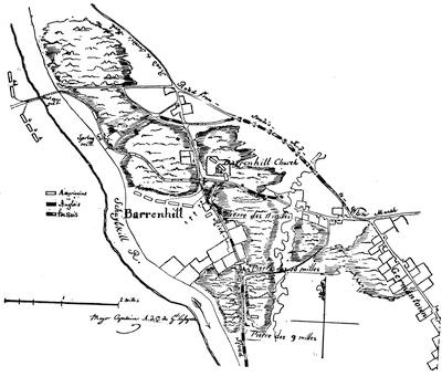
BARREN HILL.
This map is sketched and reduced from a MS. map preserved in the Historical Society of Pennsylvania, signed "Major Capitaine, A. D. C. du Genl. Lafayette", and called Plan de la retraite de Barrenhill en Pensilvanie, où un detachement de 2,200 hommes sous le Général la Fayette, etoit entourré par l'armée Anglaise sous les Gx. Howe, Clinton, et Grant, le 28 May, 1778. It bears the following Key: (translation) a. Position of the American detachment on Barren Hill, eleven miles from Philadelphia and twelve miles from Valley Forge, on the right bank of the Schuylkill. b. Pickets of the Americans, which retired on the approach of the enemy. c. A French company under Captain M'Clean, with fifty Indians. e. Place where the militia were ordered to gather, but they failed to do so. f. March of Maj.-Gen. Grant at the head of grenadiers and chasseurs, and two brigades, making in all 8,000 men, with 15 pieces of cannon. g. Where the enemy were first discovered. h. Americans occupying the meeting-house and burial-ground, deploying to defend their left flank. i. March of the detachment on the second warning to reach Matson's Ford. k. Chasseurs detached to confront Gen. Grant. l. Body of English cavalry, followed by a body of grenadiers and chasseurs. m. March of Gen. Grant, always following the Americans. n. Matson's Ford, which the Americans gained and passed, when they occupied the highlands, o, while a small force was sent to Swede's Ford. p. Rich road by which Howe and Clinton advanced with the rest of the British army. q. Point where Howe and Grant formed, whence, seeing that their attempt had failed, they returned to Philadelphia. r. Road from Swede's Ford, by which the American detachment returned the next day to occupy Barren Hill.
There is among the Sparks maps at Cornell University a duplicate copy of this map, made from Lafayette's original. Cf. maps in Sparks, v. 378; Carrington's Battles, p. 408; Lossing, ii. 329; and the view of the church (p. 322).
Clinton, on relieving Howe from the command in Philadelphia, was instructed to evacuate the city (Sparks, v. 548). This materially changed the plans for the campaign, which had been determined upon prior to the announcement of the French alliance (Sparks MSS., xlv. and lviii.). Washington meanwhile was considering an alternative of plans, and getting the opinions of his general officers;[947] but the movements of the British to evacuate Philadelphia soon changed all.[948]
PLAN OF MONMOUTH BATTLE.
From a plan in Hilliard d'Auberteuil's Essais, i. p. 270. Key: The English had passed the night at a. Lee's advance showed itself at 3, when the British debouched from their position at 1, while their guns at 2 fired on the Americans. The Americans at 3 retired into the wood, and joined Lee's main body, which debouched from the wood at 4, their guns taking position at 6 and 7, while the British guns were at 5. The Americans (4, 8, and 10) retired and took position at 11; and while still further retreating, the British attacked at 12, and the Americans made a stand at 13, and before all could retire still farther the British again attacked at 14. The Americans again formed at 15, when Washington, coming up by way of the new Baptist meeting-house with the main body, formed at 16, Stirling and Greene in front, and Lafayette in the rear, while Lee's men at 15 passed to Washington's rear, a British reconnoitring force appearing meanwhile at 17, and Plessis-Mauduit's battery, supported by 500 men, taking position at 18. The British at 14 and 17, being repulsed, united at 19, whence they were further repulsed and took position at 20. They formed again at 21 after Washington's attack. They passed the night at 22.
This map was apparently engraved from an original, followed in two plans, differently drawn, but in effect the same, which are among the maps in the Sparks collection at Cornell University, and which were copied from Lafayette's own plan at Lagrange. It is called Carte de l'affaire de Montmouth, où le général Washington commandait l'armée Américaine et le général Clinton commandait l'armée Anglaise, le 28 Juin, 1778. The "legende" shows references from 1 to 22, with extra ones a and b, the latter (b) being at the junction of the two dotted lines in the rear of 16, and is explained as the "movement of the second line, commanded by General Lafayette, which, as soon as the column at 17 was perceived, was detached to occupy the wood west of the meeting-house, which the column 17 was approaching; but when this column 17 was repulsed the line was restored."
There is also among the Sparks maps (Lafayette copies) a pen-and-ink sketch-plan,—differing somewhat, giving more detail,—made on the American side, and this more nearly resembles the plan given by Sparks in his Washington (v. p. 430,—repeated in Duer's Stirling, ii. 196; and in Guizot's Washington. Cf. Irving's Washington, quarto ed.). The plan in Lossing's Field-Book (ii. 356) is based on the one here engraved, and he also gives a view of the Freehold meeting-house (p. 359) and of the field (p. 362). Carrington (ch. 56) gives an eclectic plan with more detail than any other.
A view of the monument commemorating the battle is in the U. S. Art Directory (1884).
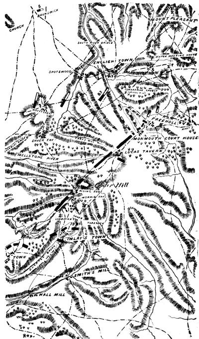
MONMOUTH AND VICINITY.
Sketched from a part of a MS. Hessian map in the library of Congress, called Plan générale des opérations de l'armée Britannique contre les Rebelles, etc. The lines (·—·—) represent roads. Key: "79, Marche du général de Knyphausen de son camp devant Englishtown le 24 Juin. 80, Marche du général Cornwallis. 83, Retraite des enemis."
There is a copy of the map of the region of the march by Clinton's engineer in the library of the N. Y. Hist. Soc. (Mag. of Amer. Hist., Sept., 1878, p. 759).
The battle of Monmouth, though in the end a victory for Washington, secured for the British what they fought for, a further unimpeded march toward New York. Washington's letters are of the first importance.[949] We have also accounts by Hamilton;[950] by Lafayette,[951] as given to Sparks; and statements by several other witnesses.[952]
The trial of Lee, and the papers produced by it, furnish abundant contemporary evidence. The trial was published at Philadelphia, 1778, as Proceedings of Court-Martial held at Brunswick in New Jersey, July 4, 1778.[953]
On the British side, Clinton's despatch is in Lee Papers, (1872), p. 461; Dawson, i. 415. A British journal kept during the march is in the N. J. Hist. Soc. Proc., i. 15; an orderly-book picked up on the field is in a transcript in the Penna. Hist. Society.[954]
The British retreat is commended in Baron von Ochs's Betrachtungen über die neuere Kriegskunst (Cassel, 1817). Cf. Lowell's Hessians, p. 209.
Respecting the Conway Cabal, the best gathering of the documentary evidence is in an appendix to Sparks's Washington.[955] Sparks's conclusion is that the plot never developed into "a clear and fixed purpose", and that no one section of the country more than another specially promoted it. Mahon (vi. 243) thinks that Sparks glides over too gently the participation of the New Englanders, who have been defended from the charge of participation by Austin in his Life of Elbridge Gerry (ch. 16). Gordon implicates Samuel Adams, and J. C. Hamilton is severe on the Adamses (Repub. U. S., i. ch. 13, 14). Mrs. Warren found no cause to connect Sam. Adams with the plot, and Wells (Sam. Adams, ii. ch. 46) naturally dismisses the charge. It is not to be denied that among the New England members of Congress there were strong partisans of Gates, and the action of Congress for good in military matters was impaired by an unsettled estimate of the wisdom of keeping Washington at the head of the army, though it did not always manifest itself in assertion (Greene's Greene, i. 287, 403, 411). Nothing could be worse than John Adams's proposition to have Congress annually elect the generals (Works, i. 263); and he was not chary of his disgust with what was called Washington's Fabian policy. Sullivan, in one of his oily, fussy letters to Washington (Corresp. of the Rev., ii. 366) finds expression of a purpose to revive the plot in William Tudor's massacre oration in Boston in March, 1779. The expressions of Charles Lee, that "a certain great man is most damnably deficient" (Moore's Treason of Lee, p. 68), like utterances of others, are rather indicative of ordinary revulsions of feeling under misfortunes than of a purpose of combination among the disaffected. Gates's refusal to reinforce Washington, and Hamilton's vain efforts to persuade him, naturally fall among the indicative signs;[956] and this apathy of Gates very likely conduced immediately to the loss of Fort Mifflin at the time it was abandoned (Wallace's Bradford, App. 12). The attempt to gain over Lafayette by the attractions of a command in invading Canada, can be followed in Sparks's Washington.[957]
THE TREASON OF ARNOLD.
A CRITICAL STUDY OF THE AUTHORITIES BY THE EDITOR.
Just when and by what act Arnold was put in treasonable correspondence with the British is not clearly established. Bancroft[958] says it was towards the end of February, 1779,[959] but he gives no authority.
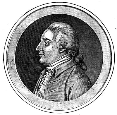
ARNOLD.
After the medallion, engraved by Adam, of a picture by Du Simitière, painted in Philadelphia from life. The original is in Marbois' Complot d'Arnold et de Sir Henry Clinton (Paris, 1816), where it is inscribed "Le Général Arnold, déserté de l'armée des Etats Unis, le 25 Septbre, 1780." The copy of Marbois in the Brinley sale (no. 3,961) had also the sepia drawing from which the engraver worked. The Du Simitière head had already appeared in the European Magazine (1783), vol. iii. 83, and in his Thirteen Heads, etc.
A familiar profile likeness, looking to the right, was engraved by H. B. Hall for the illustrated edition of Irving's Washington, and is also to be found in H. W. Smith's Andreana. Another profile, similar, but facing to the left, is in Arnold's Arnold, and was etched by H. B. Hall in 1879. Cf. Harris and Allyn's Battle of Groton Heights.
Lossing has given us views of Arnold's birthplace in Norwich (Harper's Mag., xxiii. 722; Field-Book, ii. 36), and of his house in New Haven (Harper, xvii. 13; Field-Book, i. 421), and of his Willow (Harper, xxiv. 735).
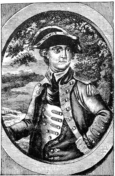
BENEDICT ARNOLD.
From the Geschichte der Kriege in und ausser Europa, Eilfter Theil, Nürnberg, 1778.
Clinton, in Oct., 1780,[960] says it was eighteen months before, which would place it about April, 1779, and this is the period adopted by Sparks[961] and Sargent.[962] The latter writer thinks Arnold made the advances; the former believes them to have come from the British.[963] It has also been believed that the mutual recognition was effected in some way through a Lieutenant Hele, a British spy, who was in Philadelphia after Arnold took command. There might arise a suspicion that the understanding was induced through the Tory family of Miss Peggy Shippen, whom Arnold had married in April, 1779. There are stories of her maintaining correspondence with her British friends in New York, but we do not know of any letters remaining as proof of it, except one from André to that lady after her marriage to Arnold, and after the British correspondence with him under feigned names had begun, in which letter the gambolling Major André commiserated his fair friend of the previous winter on the difficulty she might experience in buying gewgaws in Philadelphia, and offering to find them for her in New York. Whether this language, like the commercial phrases in which Arnold was at this time conducting his correspondence under the name of "Gustavus" with one "John Anderson", a British merchant in that city, was likewise a blind is not probably to be discovered, and it might or might not involve a doubt as to the privity of Peggy Arnold in the rather lagging negotiations;[964] but the probability is that André wrote the letter in his own name in order that Arnold might, by the similarity of the handwriting, identify his pseudo Anderson; for by this time the nature of information which inured to the advantage of the British, and which Gustavus communicated to Anderson from time to time, had pretty well convinced Clinton that the person with whom he was dealing was high in rank, and probably near headquarters in Philadelphia.
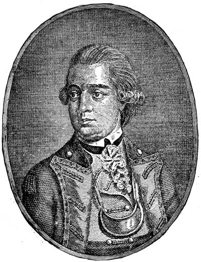
ARNOLD.
From Murray's Impartial Hist. of the present War, ii. p. 48.
Arnold had warm admirers; and those who trusted him for certain brilliant merits in the field included, among others, Washington himself; but Congress did not confide in him with so unquestioning a spirit. That body had raised over him in rank several of his juniors, much to Arnold's chagrin[965] and Washington's annoyance; and it was only after a renewed exhibition of his intrepidity at Danbury that it had tardily raised him to a major-generalship. Though his commission of May, 1777, gave him equal rank, it made him still, by its later date, the junior of those who had been his inferiors.[966] The Burgoyne campaign had been fought by him under a consequent vexation of mind, and his spirits chafed, not unreasonably, at the slight. The wound he then received incapacitating him for the field, had induced Washington, as has been shown, to put him in command of Philadelphia after the British evacuated it. It was now observed that he more willingly consorted with the Tory friends of his wife than with the tried adherents of the cause. His arrogance and impetuosity of manner always made him enemies. The Council of Pennsylvania by a resolution (Hist. Mag., Dec., 1870), as we have seen, brought Congress to the point of ordering a court-martial to decide upon the charges preferred against the general, and to Arnold's revulsion of feelings at this time has been traced, by some, the beginning of his defection.[967] Certain it is that he was kept in suspense too long to render him better proof against insidious thought, for it was not till December, 1779, that the trial came on. Meanwhile his debts pressed, his scrutinizers were vigilant, and there seems some reason to believe that he sought to get relief by selling himself to the French minister,—a project which, if we may believe the account, was repelled by that ambassador. To add to his irritation, Congress did not find the accounts which he had rendered of his expenditures in the Canada expedition well vouched, and Arnold resented their inquiries as an imputation upon his honesty.[968]
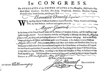
ARNOLD'S COMMISSION AS MAJOR-GENERAL.
Reduced from the fac-simile given in Smith and Watson's Hist. and Lit. Curios., 1st series, plate xlii.
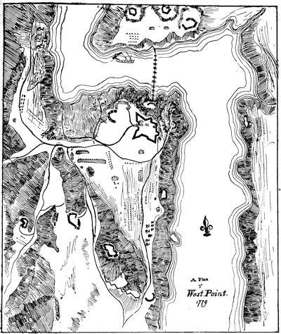
WEST POINT.
Sketched from a colored drawing in the Moses Greenleaf Papers (Mass. Hist. Soc.).
The trial at last resulted in his acquittal on two of the more serious charges; but being judged censurable on two others, he was sentenced to a public reprimand from the commander-in-chief.[969]
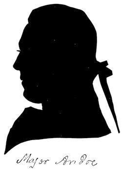
A profile cut by himself for Miss Rebecca Redman, in 1778, and given in Smith and Watson's Hist. and Lit. Curiosities, 1st series, pl. xxv.
The burden of a public reproof, no matter how delicately imposed, was not calculated to arrest the defection of man already too far committed to retreat. If we may believe Marbois, not the best of guides, there was found among Arnold's papers, after his flight, a letter, undated and unsigned, in which he was urged to emulate the example of Gen. Monk, and save his country by an opportune desertion of what was no longer a prospering cause.[970] It soon became evident to Arnold that of himself, destitute of representative value, he was not a commodity that Clinton was eager to buy. Accordingly the recusant soldier sought to offer a better bargain to the purchaser by the makeweight of something that Clinton particularly longed for, and this was the possession of the Hudson Valley through its chief military posts.[971] To get a hold upon this, the time was opportune, for there was a change to be made in its commander. Arnold, however, did not get the coveted prize without some intrigue, for Washington, when he found that the wounded soldier professed eagerness for hotter work, proposed his taking the command of one of the wings of the main army. Arnold met the compliment by referring to his wounds as precluding work in the saddle, and induced Schuyler and R. R. Livingston to importune Washington to assign him to West Point.[972] The device succeeded, and Arnold reached West Point, as its commander, in the first week of August, and established his headquarters in the confiscated house which had belonged to Beverley Robinson, and which was situated on the east bank of the river, a little below West Point.[973] Clinton could have no longer any doubt of the identity of his correspondent, now that "Gustavus" wrote from the Robinson house.
The conspirators' first effort was to establish communications through Robinson, on business ostensibly having relations to this confiscated property; but Washington, to whom, for appearances, Arnold showed Robinson's application for an interview, told him that the civil, and not the military, powers should meet such proposals. Arnold could find at this time little difficulty in transmitting his clandestine letters, for there was constant occasion for the passage of flags from his own headquarters. To cover his proceedings from the officers of the American outposts, he only had to pretend that the expected messages or messengers were from his own spies in New York.[974]
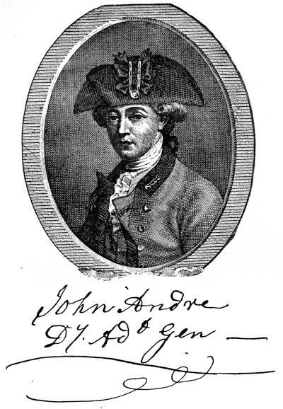
From the Political Magazine, March, 1781, ii. 171. There is a modern reproduction of this engraving in the Minutes of a Court of Inquiry, etc., Albany, 1865. and in H. W. Smith's Andreana, Phila., 1865, who gives a full-length, of the origin of which we are left uninformed.
Clinton was apparently not willing to commit himself to any bargain, unless Arnold would give a personal interview as an evidence of his sincerity; while Arnold, in according, on his part insisted that his interviewer should be the convenient Anderson. André, since he had become the adjutant-general of the British army, was now fully understood to represent that fictitious New York merchant. Arnold named Robinson's house for the meeting, and would make arrangements by which any flag should pass the outposts. This was objected to, and the neutral ground near Dobbs Ferry was settled upon. Here Arnold went in his barge; but the officers of the British guard-boats were not in the secret, and the meeting failed by reason of their chasing Arnold's barge up the river. Another attempt was planned, but this failed in the beginning, apparently by André's going up to the "Vulture", sloop-of-war, which was lying in the river, instead of landing lower down, as was expected. André was provided with full instructions, which if obeyed would have saved him the ignominy of a felon's death. He was not to put off his uniform, was not to go within the American lines, and was not to receive any papers. His bargain with Arnold was to have no written expression, and it involved on Sir Henry's part the dispatch of an ample force in a flotilla from Sir George Rodney's fleet, then in New York, where the men were already embarked, ostensibly for the Chesapeake, and the attack was to be made on the 25th of September, when it was supposed that Washington would have left the Hudson to go to Connecticut for an interview with Rochambeau. There was further to be made by André a promise that Arnold should have a commission in the British army and a sum of money. The American general, on his part, was so to dispose the forces in the works about West Point that the attack would, beyond doubt, end in a surprise and a mastery that would give color to the necessity of a surrender, which he was promptly to make.
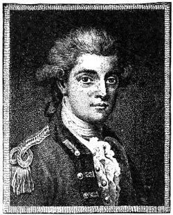
ANDRE.
This picture of André, by himself, was originally engraved in 1784 by J. K. Sherwin, and was reëngraved by Hopwood for J. H. Smith's Authentic Narrative, London, 1808, and from this second engraving the present cut is taken. It has of late years been engraved by H. B. Hall in Sparks's Washington, quarto ed., vol. iv.; H. W. Smith's Andreana; Sargent's André; Mag. of Amer. Hist., 1879, p. 745 (etched by H. B. Hall). What seems to be the same, but extended to include the thighs, is given in Lossing's Field-Book, ii. 197; Two Spies, 36. A picture by Reynolds (given in Harper's, lii. 822, and Cyclop. U. S. Hist., i. 46) is said to be preserved at Tunbridge Wells. A pen-and-ink sketch by himself, made during his confinement, is now preserved in the Trumbull gallery at New Haven. Sparks first engraved it, and it has since been reproduced by Lossing, in Harper's Mag., xxi. 4, in Smith's Andreana, and elsewhere.
It now became necessary that some device should be practised to let Arnold know that André had reached the "Vulture." There had just happened some firing upon a boat of the "Vulture", in going to meet what the British captain supposed or pretended to suppose a white flag displayed on the shore. This gave the opportunity of dispatching a flag to the commander in the Highlands, to remonstrate against such perfidy. The British captain accordingly sent such a message, and André wrote the letter in a hand which he knew Arnold would recognize, and moreover countersigned it with "John Anderson, Secretary."
Arnold at once bent to the occasion. He engaged one Joshua Hett Smith, who lived in the neighborhood, to go by night to the "Vulture" in a boat, and bring to the adjacent shore a gentleman whom he would find on board, from whom Arnold expected to get information. How far Smith was a dupe or a knave has never been satisfactorily determined. The business would seem to have had a plain significance to a quick-witted man; but a court was not able later to convict Smith of knowing precisely what it all meant. Smith had also with him two oarsmen, and it was not apparently believed that they were in a position to know enough to render their patriotism doubtful. It was then by night, in a boat steered by Smith, that André, dressed in his uniform, but with an overcoat wrapped about him, was rowed ashore. According to Smith, the darkness and the outer garment so concealed Andre's dress that his steersman never suspected him to be an officer. Arnold was found waiting in the bushes, a little remote from the landing. Here Smith left the two conspirators alone and returned to his boat; but when the signs of dawn began to appear he returned to warn them. Arnold, who had brought along with him an extra horse, mounted André on it, and the two started to go to Smith's house,[975] which was two or three miles away on the hill, and within the American lines.
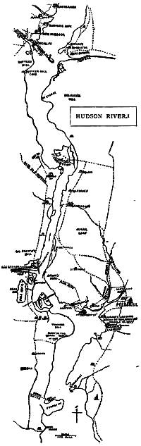
HUDSON RIVER.
Reduced from a rough pen-and-ink sketch, three feet and eight inches long, preserved among the Sparks MS. maps in Cornell University library, and inscribed "To his Excellency George Clinton, Esqr, Governor of the State of New York, this map of Hudson's River through the Highlands is humbly dedicated by his Excellency's most humble servant Thomas Machin, iv. January, MDCCLXXVIII."
If André is to be believed, he was not told that he was to go within the American outposts, and indeed there is no conclusive evidence to show why they went to Smith's house at all. Perhaps Smith or the boatmen refused, in the growing light, to take the risk of the return to the vessel. The general opinion has been that the conspirators had not concluded their negotiations, and needed more time. That Arnold had had a predetermined purpose to go to the house, if necessary, seems to be made clear from the fact that he had induced Smith to move his family away from their home temporarily, and on some pretext which Smith did not object to. André says that he first discovered Arnold's plan to get him within the American lines when, as they rode on their way, Arnold gave the countersign at the outposts. This was the first departure from Clinton's instructions. After they had reached the house the day broadened, and, the sound of cannon being heard, André went to a window, whence he could see the "Vulture" in the distance,[976] and saw that the Americans had dragged some cannon to a neighboring point, whence their fire became so annoying that the vessel raised her anchor and fell down the river. André became anxious lest this incident should preclude his return by water. The day had not far advanced when the bargain was completed, and Arnold prepared to leave for West Point to perfect the dispositions expected of him. He left behind sundry papers, mostly in his own handwriting, which André was to take to Clinton. Why another injunction of his superior was evaded by André in accepting the papers is not clear. They conveyed no information about the condition of the post which Clinton did not already possess or André could repeat to him. Possibly it was thought that, being in Arnold's autograph, the documents might serve as a pledge for what André was verbally to report to him.
Arnold seems to have made no certain provision for his fellow-conspirator's return to the "Vulture", but he left passes, which could be used either on the water or land passage, as circumstance might determine. André spent an anxious day after Arnold left. He was finally cheered by observing that the "Vulture", as if mindful of him, had returned to her previous moorings; but his hopes were futile. As night came on Smith showed no signs of arranging for a water passage to the ship, and made excuses.
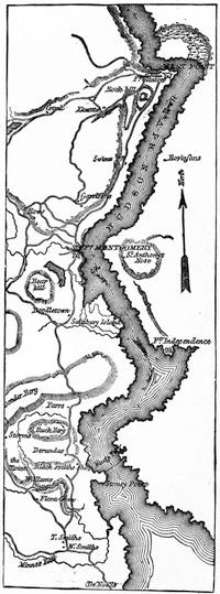
HUDSON RIVER.
After the original draft by Major Villefranche (1780) as reproduced in Boynton's West Point, p. 45. Sargent, in his André, gives a map "engraved from a number of original drawings by Villefranche and other engineers, and preserved by Major Sargent, of the American army, who was stationed at West Point as aide to General [Robert] Howe until that officer was relieved by Arnold."
The fact probably was, that, after the cannonading of the morning, Smith had no desire to risk himself on the river in a boat. It was accordingly agreed that André should undertake to return to New York by land, and that Smith should accompany him beyond the American outposts, under the protection of Arnold's pass and of his own acquaintance with the officers of the lower posts. It now became necessary for André to disregard another of Clinton's directions, and exchange his uniform for common clothes.[977] This done, he put the papers which Arnold had given him under his soles and within his stockings. Thus arrayed, about dusk the two started, accompanied by Smith's negro servant. They crossed King's Ferry, and proceeding on their way were stopped once, but suffered to advance on showing Arnold's pass. After spending the night at a house, they had gone on some distance the next morning when Smith parted with André, and, going to Robinson's house, reported to Arnold that André had been conducted beyond the lines. André went on in better spirits than before, feeling sure now that he could encounter nothing more serious than some wandering cowboys, as the British marauders who infested the Neutral Ground between the two armies were called, and with whom he could easily parley to their satisfaction. The natural foes of the "Cowboys" were the "Skinners", who harried the unfortunate adherents of the British along the same roads, and wrestled with the Cowboys as opportunity offered.[978] As it happened, a party of the American prowlers were out to intercept some British marauders, and three of the number were ensconced close by a stream not far from Tarrytown, on the upper side. They were by name John Paulding, David Williams, and Isaac Van Wart. Paulding was by force of character the leader, and was dressed in a refugee's suit, which not many days before had been put upon him in exchange for his own better garments, when he had come out from confinement within the British lines. This suit, as well as Paulding's profession that he was "of the lower party", given to André's inquiry when, as he came along, he was stopped by the men, led to André's revealing himself as a British officer. When the traveller found he had made a mistake, he showed Arnold's pass, and tried to enforce it by threats of the American commander's displeasure if the captors dared to disregard it. This failing, he tried bribes, and it was André's opinion that if he could have made the payment sure he might have got off, as money seemed to be their object. The men, on the other hand, said that they could have resisted any offer of money when, on searching their prisoner, they found the papers in his boots.[979] Paulding, who alone could read, saw the purport of the documents, and pronounced André a spy.
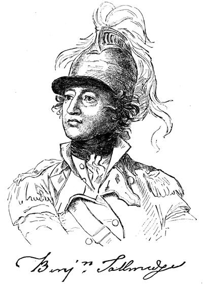
COLONEL BENJAMIN TALLMADGE.
After a sketch taken by Colonel Trumbull, at the close of the war, and engraved in the Memoir of Col. Benjamin Tallmadge, prepared by himself at the request of his children, New York, 1858. A portrait in his later years, painted by E. Ames and engraved by G. Parker, is in the National Portrait Gallery, Philadelphia, 1836, vol. iii.
André was remounted and led under their combined guidance to the quarters[980] of Colonel Jameson, who commanded some dragoons at Northcastle. That officer recognized Arnold's handwriting in the papers found on the prisoner, but he seems to have been bewildered by the discovery, though it was afterwards urged that he thought the transaction was a plot of "John Anderson", whoever he might be, to implicate Arnold in some mischief. How far the prisoner himself may have prompted Jameson is not known, for it was clear enough to André that Arnold only could now extricate him from the gathering toils. Accordingly, events took a promising turn for him when Jameson dispatched the prisoner, under escort, to Arnold's headquarters, with a letter which informed his superior of what was apparent enough, that some dangerous papers had been found on Anderson, and that he had sent them to Washington. Major Benjamin Tallmadge, one of his officers, who was absent on a scout, returned before André had long been gone, and learning the particulars from Jameson saw at once the blunder, and persuaded Jameson to send a messenger to recall André and his escort. Jameson did so, but insisted that the letter to Arnold should go on, as it did.
The messenger with the papers sought to intercept Washington on the lower road from Hartford, which the commander-in-chief was supposed at that time to be traversing on his return from the interview with Rochambeau.
The next morning André was sent, for better security, in the charge of Tallmadge to Colonel Sheldon's quarters at New Salem. Here, getting permission to walk in the door-yard in the custody of an officer named King, André revealed his name and station, and being allowed pen and paper, he made the same avowal in a letter to Washington, which, when written, he handed to Tallmadge. Its contents confirmed that officer's suspicion that the prisoner was a military man, for he had shown a soldier's habit of turning on his heel as he paced his room.
Washington, returning by the upper road, had missed Jameson's messenger, who, retracing his steps, passed through New Salem, where he was entrusted also with the letter which André had just written, and then went on towards the Robinson house, where Washington was then supposed to be.
It was now the 25th, the very day when Rodney was to come up the river with his flotilla, and Arnold sat at breakfast at this same Robinson house,[981] not knowing what the day would develop. There were with him Mrs. Arnold, who had not long before (Sept. 15) come from Philadelphia, and two of Washington's aides, who had arrived a little in advance of their chief.
It was two days earlier than Washington had been expected back, and this was a serious perplexity in the mind of the conspirator. The suspense was soon ended, for Jameson's messenger to him shortly arrived, and the letter was put in Arnold's hands before the company. He read it, showed, as was remembered afterwards, a little agitation, but only a little, and in a few minutes left the table, saying that it was necessary for him to go to West Point. It seemed natural enough to his guests; but Mrs. Arnold observed his agitation more keenly, and followed him to their chamber, where all was revealed to her. She swooned; he kissed the infant lying there; descended the stairs;[982] stopped an instant to say to the breakfast party that Mrs. Arnold was not feeling well and would not come down again; mounted a horse which he had already ordered; hurried down the steep road to the river; entered his barge and seated himself in its prow; directed his men to row to mid-stream; and then priming his pistols, which he had taken from his holster, he ordered them to hurry down the river, as he had to go with a flag to the "Vulture", and must hasten back to meet Washington, who was shortly to reach his quarters. He tied a white handkerchief to a cane, and waved it as he passed Livingston's batteries at Verplanck's Point, and that officer recognizing the barge allowed it to pass on. In a few minutes more he was under the "Vulture's" guns, and then under her flag. His boatmen resisted his offers of recompense for desertion, and were not allowed to return to shore to spread the intelligence, which they now comprehended.[983]
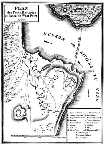
WEST POINT.
Reproduced from the plan in Marbois' Complot d'Arnold et de Sir Henry Clinton, Paris, 1816. A plate in the Mag. of Amer. Hist., 1879, p. 756, showing the route of André, is a portion of a map among the Simeon de Witt's maps (i. no. 66) in the library of the New York Hist. Society, and was made by Robert Erskine, the topographical engineer of the army, 1778-1780, and was for the whole length of it, from Staten Island to Newburgh, engraved for the first time in Irving's Washington, quarto ed., ii. 276.