Chapter VI · (continued 3)
Reading edition
The first, "Stoney Point", is from a pen-and-ink sketch, indorsed "From Genl. Heath, letter 3d July, 1779", which is among the Sparks maps in Cornell University library, and carries the following Key: 1, the capital work on the highest part of the point, commanding the out-flêches, which is conformed to the broken eminence it is built on; 2, 3, 4, 5, flêches built on so many little eminences, each with one embrasure; but in the principal work (1) the number of embrasures is uncertain, being covered by the works and the declivity of the hill. Two rows of abatis (× × ×) cross the point from water to water. The other plan, marked "Verplanck's Point", is sketched from a pen-and-ink drawing in the same collection, also indorsed "From Genl. Heath, letter 3d July, 1779", and bears this Key: 1, Fort de la Fayette, with block-house and barbette battery; 2, board huts in form of tents; 3, American barbette; 4, British tents, about one regiment; 5, 6, two new flêches by the Britons; 7, block-house on a stony hill, with a redoubt. The abatis is marked × × ×.
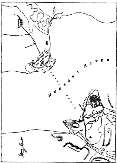
FADEN'S STONY POINT, 1779.
The lead of the movement was entrusted to Wayne. His instructions, in Washington's handwriting, are given in Dawson, in fac-simile (p. 18). His orders are dated July 15 (Niles, Principles, 1876, p. 495; Essex Inst. Hist. Coll., v. 7). Wayne's first report of his successful attack to Washington is given in fac-simile in Armstrong's Wayne, Dawson, and Lossing (ii. 179); and his longer account of the next day is in Sparks's Washington, vi. 537; and in Ibid. vi. 298, is Washington's report to Congress. H. B. Dawson's Assault on Stony Point (Morrisania, 1863) is an elaborate monograph. H. P. Johnston has a special paper in Harper's Monthly lix. 233 (July, 1879), and J. W. De Peyster another in the N. Y. Mail, July 15, 1879, while a controversy of Johnston and De Peyster is in the Monmouth Inquirer. "Who led the forlorn hope at Stony Point?" is discussed in the Penna. Mag. of Hist., Oct., 1885, p. 357. Cf. Armstrong's Wayne; Dawson's Battles; Moore's Diary, ii. 192; Penna. Archives, vii.; Marshall's Washington, iv. ch. 2; Irving's Washington, iii. 465; Hull's Rev. Services, ch. 16; Reed's Reed, ii. 110; Kapp's Steuben, ch. 11; Hamilton's Republic, i. 443; acc. of Col. Febiger in Mag. Amer. Hist., March, 1881; Duncan's Royal Artillery, 3d ed., ii. 353; Pattison in N. Y. Hist. Soc. Coll., 1875, p. 95; and Gen. Joseph Hawley's Centennial Address, July 16, 1879. The British later reoccupied the post (Sparks's Corresp. of Rev., ii. 328).
The chief map of the attack is a Plan of the Surprise of Stoney Point, 15 July, 1779, from surveys of Wm. Simpson, Lt. 17th Regt. and D. Campbell, Lt. 42d Regt., by John Hills, Lt. 23d Regt., London, Faden, March 1, 1784. There is a fac-simile in the N. Y. Calendar of Hist. MSS., p. 347, and in Dawson. It needs the following Key: 1, Two companies of the 17th regiment. 2, Ditto. 3, Sixty of the loyal Americans. 4, Two grenadier companies of the 17th regiment. 5, A detachment of the royal artillery. A, Ruins of a block-house erected and destroyed by the Americans. B, A temporary magazine. C, One 24 and one 18 pounder, ship guns. D, Ditto. E, One iron 12-pounder. F, One 8-inch-howitzer. G, One brass 12-pounder. H, One short brass 12-pounder. I, One long brass 12-pounder. Cf. plans in Hull's Revolutionary Services, ch. 16; Sparks's Washington, vi. 304; Guizot's Washington, Atlas; Lossing's Field-Book, ii. 175. The medals given to Wayne, De Fleury, and Stewart are described in Loubat. (Cf. Lossing, ii. 180, 181.) A rude view of the capture in Bickerstaff's (Boston) Almanac, 1780, is reproduced in Mag. Amer. Hist., xvi. 592.
A few weeks later (Aug. 19), Major Henry Lee emulated Wayne in a sudden attack on Paulus Hook (Jersey City). We have reports on both sides. That of the British, General Pattison's, is in Duncan's Royal Artillery, ii. 355, and his letter to Townshend in N. Y. Hist. Coll., 1875, p. 79. On the American side we have accounts in Sparks's Washington, vi. 317, 326, 332-336, 376; Lowell (Hessians, 228) says that R. E. Lee's statement (in H. Lee's Memoirs) that Paulus Hook was captured by a stratagem is not borne out by Marshall (Washington, iv. 87) or by the German accounts (Ewald, ii. 295). Cf. Moore's Diary, ii. 206; Irving's Washington, iii. 475; Dawson's Battles; Quincy's Shaw, 65; Reed's Reed, ii. 125; Duer's Stirling, 204; Bancroft, x. 229; J. W. De Peyster in N. Y. Mail, Aug. 18, 1879; and S. A. Green in Hist. Mag., Dec., 1868 (2d ser., iv. 264). George H. Farrier prepared a Memorial of the centennial celebration of the battle of Paulus Hook, Aug. 19th, 1879 (Jersey City, 1879), which has an appendix of documents.
Loubat and Farrier give an account of the medal presented to Lee.
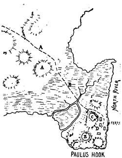
The annexed sketch, "Paulus Hook", is from a draft of an original Hessian map in the library at Cassel, furnished by Mr. Edward J. Lowell (cf. his Hessians, p. 228), with the following Key: A, Covering force of the attacking Americans. B, Line of attack on the block-houses (1, 2, 3) and fort (C), which mounted seven six-pounders, which were not used. D, Barracks in which one hundred and ten prisoners were taken. E, Work occupied by a Hessian captain, one officer and twenty-five men, possessed at the time the Americans retired, at daybreak. (Cf. plan in Lossing, ii. 828.) Farrier gives a plan from an original in the library of Congress.
The winter of 1779-80 was an exceptionally severe one in the North (Jones's N. Y., i. 320; Greene's Greene, ii. 184; Leake's Lamb; Almon's Remembrancer, ix.) After Clinton had gone South to attack Charleston, Knyphausen was left in command in New York (Eld's journal in Mass. Hist. Soc. Proc., xviii. 73; Eugene Lawrence on life in N. Y. in Hist. Mag., i. 37; Jones's N. Y. during the Rev., vol. ii.).
October 18-19, 1779.
Washington was encamped at Morristown, New Jersey. Views of his headquarters are in Lamb's Homes of America; Appleton's Journal, xii. 129; Lossing's Field-Book, i. 309, and his M. and M. Washington, 191. (Cf. Poole's Index, p. 873; Harper's Mag., xviii. 289; Mag. of Amer. Hist., iii. 89, 118.) Letters of Washington, while in Morristown, in addition to those given in Sparks, are in Mag. Amer. Hist., iii. 496. Orderly-books are in N. Y. Hist. Soc. cabinet and in Mass. Hist. Soc. Proc., xvii. 48.
The trials and deprivations of the army were so great that Washington did not dare take advantage of an ice-bridge formed across the Hudson, for an attack on New York, though the British feared that he might. There were varying councils on this point in the American camp (Duer's Stirling, ch. viii.). The British apprehension (Feb., 1780) is shown in Duncan's Royal Artillery, ii. 359; N. Y. Hist. Soc. Coll., 1875, pp. 147, 152. The difficulties in the American camp are followed in Irving's Washington, iv. ch. 1 and 4; Thacher's Mil. Journal; J. F. Tuttle in Hist. Mag., June, 1871, and Harper's Mag., Feb., 1859. A lack of money in the paymasters' chests caused dissatisfaction, which grew into an insurrection. The British, seeking to increase the trouble, marched into New Jersey, under General Matthews, but they were driven back, and waited on the coast till Clinton, returning from Carolina, reinforced them, when they again advanced. Washington, meanwhile, suspecting an incursion up the Hudson, had gone thither with a large part of his troops, leaving Greene at Morristown. Greene met the British and defeated them at Springfield, when they returned to New York. The progress of these events can be followed. On the American side, Greene's Greene, ii., and his letters in Sparks's Washington, vii. 75, 506; Gordon, iii. 368; Marshall's Washington; Sedgwick's Livingston; Bancroft, x. ch. 18; Irving's Washington, iv. 6; Carrington, 502; Lossing, i. 322; in histories of N. Jersey; Atkinson's Newark, 104; Hatfield's Elizabeth, ch. 22; Mag. Amer. Hist., iii. 211, 490. On the British side, Moore's Diary, ii. 285; Simcoe's Queen's Rangers; in letters in N. Y. Hist. Soc. Coll., 1875, p. 458. George Mathew, of the Coldstream Guards, wrote an account (Hist. Mag., i. 103,—App., 1857), and some details are in the Court Martial of Col. Cosmo Gordon (London, 1783). For maps, John Hill's, published by Faden, 1784, is the principal one. Cf. Carrington; Lossing's Field-Book, i. 322; and the map of Elizabethport Point (1775-1783) by E. L. Meyer, published in 1879.
What is known as the affair of Bull's Ferry (July 21, 1780) was an unsuccessful attempt by Wayne upon a block-house garrisoned by Tories. (Cf. Mag. Amer. Hist., v. 161; Armstrong's Wayne; Sparks's Washington, vii. 116; and his Corresp. of Rev., iii. 34, 37; Sargent's André, 234.) André wrote on this misadventure of Wayne the well-known doggerel verses called The Cow-Chace, part of Wayne's project having been to gather cattle. The verses appeared in three numbers of Rivington's Gazette (New York, Aug. 16, 30, Sept. 23, 1780; Menzies, $23), and were republished by Rivington separately, 1780 (J. A. Rice's sale, $265), and also in Philadelphia, 1780. The book was reprinted at London with notes in 1781; at New York in 1789 (Morrell's Catal., $36); at London in 1799, with Dunlap's tragedy of André (Menzies, 61, $23); at Albany in 1866, edited by F. B. Hough; at Cincinnati in 1869. André seems to have made several copies of the MS. Sargent prints it from one of these. Another belonged to Dr. W. B. Sprague, and Lossing printed from this (Field-Book, ii. 878; Two Spies, 68). It will also be found in Moore's Songs and Ballads, 299; J. A. Spencer's United States, vol. ii. etc.
The summer was barren of military interest. Steuben was trying to reorganize the army (Kapp's Steuben, ch. 12-15). The low condition of the army is shown in Washington's letters (Sparks, vii. 156; Corresp. of Rev., iii. 15; Mag. Amer. Hist., Aug., 1879). Washington issued a circular letter on the army's distress (New Hampshire State Papers, viii. 870; cf. Journals of Congress, iii. 469). The British intercepted some mournful letters, and printed them (Political Mag., ii. 73).
In August there was a gathering of delegates from the New England States at Boston, "to advise the most vigorous prosecution of the war, and provide for the reception of our French allies." The Proceedings of this meeting have been edited from the original MS. by F. B. Hough (Albany, 1867). In November a convention of the Northern States at Hartford sought methods of furnishing men and supplies (Mag. Amer. Hist., Oct., 1882, viii. 688; and Clinton's knowledge of it in Ibid. x. 411).
Hope revived with the prospect of the arrival of Rochambeau and the French, in July, 1780 (Heath's Memoirs, 243; Corresp. of Rev., iii. 12). The first communications of Washington and Rochambeau are in Sparks's Washington, vii. 110, and App. 4, with an account of Lafayette's conference with the French. Rochambeau's instructions are in Ibid. vii. 493. The letters of Rochambeau and Lafayette are in the Sparks MSS., lxxxv.
The English fleet blockaded the French in Newport harbor. The Political Mag., 1780, has a map showing the blockade of the French admiral Ternay by Arbuthnot. Letters of the English admiral are in the Hist. MSS. Com. Report IX., App. iii. p. 106.
On the occupation of Newport by the French, see Mason's Newport; Newport Hist. Mag., ii. 41; iii. 177; Stone's French Allies, 256; Lippincott's Mag., xxvi. 351; Drake's Nooks and Corners of the N. E. Coast; Harper's Mag., lix. 497. The correspondence of Rochambeau and the Rhode Island authorities is in the R. I. Col. Rec., ix. There is a diary of a French officer in Mag. Amer. Hist., iv. 209; and Fersen's letters are in Ibid. iii. 300, 369, 437.
Several maps of Newport and vicinity are given in the Mag. Amer. Hist., like the plan of the town by Blaskowitz; the Defences of Newport, 1781, from a MS. French chart; and the Scene of Operations before Newport, 1781, from a MS. survey by Robert Erskine, geographer to the American army, of which the original is in the cabinet of the N. Y. Hist. Society.
There are among the Rochambeau maps several plans of Newport and its neighborhood, including no. 38, Plan de Rhodes Isle et position de l'armée française à Newport, measuring 5 x 3 inches, colored and showing roads, fences, forts, and the fleet in the harbor; no. 39, Plan de la ville, port, et rade de Newport, avec une partie de Rhode Island, occupée par l'armée française, evidently by the same draftsman as the preceding, dated 1780, colored, measuring 24 x 30 inches, showing forts, Gen. Sullivan's old camp, the old line of the English, etc.; no. 41, a plan, 8 x 15 inches, called Quatre positions de la flotte française et position de la flotte anglaise; no. 42, evidently by Montresor, colored, measuring 4 x 3 inches, dated 1780, called Plan de la position de l'armée française au tour de Newport, et du mouillage de l'escadre dans la rade de cette ville. Le Rouge published a map of this title in Paris, in 1783. Cf. map in Political Mag., i. 692.
On the French participation in the war we have Rochambeau, Mémoires, with an English translation by Wright, and the Troubles of Soulés, which is supposed to have been inspired by Rochambeau. Cf. Walsh's Amer. Register, ii. The other French contemporary accounts are the Mémoires of Count Ségur and the Duc de Lauzun; the Travels of Abbé Robin and of Chastellux, of which there is an English translation by George Greive (Mass. Hist. Soc. Proc., April, 1869); the Journals of Deux-Ponts, edited by S. A. Green, and of Claude Blanchard. (Cf. Revue militaire française, and Tuckerman's America and her Commentators.) The later French accounts in general are Leboucher's Hist. de la guerre de l'indépendance des Etats-Unis; Balch's Les français en Amérique (1872), Chotteau's Les français, etc. A comprehensive later American account is E. M. Stone's Our French Allies. Cf. Lossing in Harper's Mag., xlii. 753.
Counter attacks of Clinton on Newport and of Washington and Rochambeau on New York were prevented by untoward circumstances (Sparks's Washington, vii. 130, 137, 171, with App. 6; Jones's New York during the Rev., i. 358; Mémoires of Rochambeau).
In September, 1780, Washington had an interview with Rochambeau at Hartford to devise further operations, but the plot of Arnold disconcerted all measures (E. M. Stone, 281; Irving's Washington; J. C. Hamilton's Republic, ii. 49). Alexander Hamilton had drawn up a plan of combined operations.
In October there was an unsuccessful expedition to Staten Island (Life of Pickering, i. ch. 17; R. I. Hist. Soc. Coll., ii. 257; Hist. Mag., i. 104).
Washington was now in camp at Totowa and Preakness, in New Jersey. There are a map and view of his headquarters in Mag. Amer. Hist., Aug., 1879. Cf. orderly-book in 2 Penna. Archives, xi., and Journal of Capt. Joseph McClellan in Ibid.
The Pennsylvania line was at Morristown, under Wayne, and in January, being without pay and supplies, they revolted, and marched towards Philadelphia to claim redress of Congress. The New Jersey line was similarly affected. Prompt and judicious measures quelled the mutiny, but not till some emissaries, whom Clinton had sent to increase the trouble, had been hanged by the insurrectionists. Original sources: Wayne's letters to Washington, in the Corresp. of Rev., iii. 192; Sparks's Washington, vii. 348, with App. x.; proposal of a Committee of Sergeants, with Wayne's comments, in the Sparks MSS., xxxix. p. 100 (also no. liv. 5); documents in Penna. Archives, viii. 698, 701, 704, and ix.; second series, xi.; Colonial Records, xii. 624; Hazard's Register, ii. 160; St. Clair Papers, i. 108, 532; Bland Papers, ii. Cf. also Marshall's Washington, iv. 393; Irving's, iv. 195; Hamilton's Hamilton, i. 323, and Works, ii. 147; Amory's Sullivan, 181; Madison Papers, i. 77; Reed's Reed, ii. ch. 14. Clinton's report is in Almon's Remembrancer, xi. 148. The information reaching the British camp is in Clinton's Secret intelligence, in Mag. Amer. Hist., x. 328, 331, 418, 497; an account of the hanging of the British emissaries is in the Hist. of First Troop of Philad. City Cavalry, p. 28.
Washington and Rochambeau had held a conference at Weathersfield, Conn. (May 22, 1781), to arrange for a plan of combined action (Sparks's Washington, viii. 517, for their views respecting the safety of Newport, meanwhile). The conference was held at the Webb House (Mag. Amer. Hist., June, 1880). The French army then moved by way of Providence to the Hudson, and there is among the Rochambeau maps in the library of Congress a plan of their route, with key, giving their twelve encampments on the way (nos. 42 (bis), 43, 44). Marche de l'armée française de Providence à la Rivière du Nord, 1782. In the Mag. Amer. Hist. (iv. 299) there is a map of the Route of the French from Providence to King's Ferry, following a MS. attached to a diary of a French officer.
Rochambeau established his headquarters at the Odell House, in Westchester (Stone, French Allies, 394; C. A. Campbell in Mag. Amer. Hist., iv. 46). On June 12th, the two commanders held a council of war at New Windsor (Mag. Amer. Hist., iii. 102). Clinton's secret journal shows how well the British commander was informed of what was going on (Ibid. xii. 73, etc., 162, etc.). Beside the correspondence of Washington at this time, in Sparks, there are other letters in Ibid. iv. and v. Washington's first attempt to act in union with the French was in the proposed attack on the forts on New York Island. (Cf. Washington's journal in Ibid. vi. 117; xi. 535.) There is among the Lincoln Papers (Sparks MSS., xii.) a "memorandum to regulate the movements of the allied army on the night of the 31st of July, 1781." J. A. Stevens follows the operations of the combined armies at this time (Mag. Amer. Hist., iv., Jan., 1880). He gives a map of the attempt at King's Bridge, July 3, 1781. There is among the Rochambeau maps an excellent draft, about thirty inches wide by fifteen high, showing New York with Long Island, with the French camp as high up as Tarrytown, called Position du camp de l'armée combinée de Phillipsbourg du 6 Juillet au 19 Août, 1781. Stevens gives a fac-simile of this, and also a map of the environs of New York between the Sound and the Hudson, called Surveys in New York and Connecticut States for his Excellency, Gen. Washington, by Robert Erskine, Anno 1778, W. Scull delin.,—a MS. plan in the New York Hist. Soc. library (Proc., 1845, p. 56), where is also a MS. Chart of the Harbour of New York, with a map of the Country bordering upon the Sound, and extending to the Connecticut, with the names of the principal places laid down thereon, by Robert Erskine, 1779 (N. Y. Hist. Soc. Proc., 1848, p. 188). The Rochambeau maps contain other evidences of the activity at this time of the French topographical engineers; as, for instance, a plan (no. 29) done in ink and color, measuring ten inches wide by twelve high, and not very exact, called Reconnaisance Juillet, 1781, ouvrages [de] Morrisania, Isle de New York, by Montresor and Buchanan, and a second (12 x 15 inches) which gives the works at Frog's Point (no. 30), and adds to the title "Plan d'une batterie de Long Island." Another (no. 32), called Reconnaisance des ouvrages du nord de l'Isle New York, 22-23 Juillet, 1781, measures twelve inches wide by fifteen high, apparently the work of Montresor, and shows Fort Washington, Laurel Hill, etc. It was Washington's purpose at this time to make Clinton expect an attack on New York (Sparks's Washington, viii. 54, 130, 517; Amer. Antiq. Soc. Proc., 2d series, i. 327). Clinton has recorded his reason why he did not venture to attack Washington in July and August, while the Americans were encamped at King's Bridge (New York City during the Rev., New York, 1861, pp. 177-184). By August 14th, the coöperation of the French fleet being assured, Washington decided to march to Virginia (Mag. Amer. Hist., vii.; also xi. 343; Diplom. Corresp., xi. 417). He said the main cause of his coming to this decision was the failure of the New England States to supply men (Mag. Amer. Hist., vi. 125). Washington's headquarters at this time were in the Livingston mansion (Lossing, ii. 195).
The question of Washington having been made a marshal of France has caused some discussion. Hist. Mag., ii., iii.; E. M. Stone's French Allies, 373; Balch, Les Français en Amérique, 122.
While Washington marched towards Virginia, the marauding expedition which Clinton had sent under Arnold, along the Connecticut coast, failed to divert him from his purpose, as the British commander had hoped it would. The attack fell upon New London and Groton, early in September. Trumbull's letter to Washington is in the Corresp. of Rev., iii. 403. Cf. Stuart's Trumbull, ch. 45; Arnold's account in the Polit. Mag., ii. 666; Sparks's Arnold, and Arnold's Arnold; "Sir Henry Clinton and the burning of New London", in Mag. Amer. Hist., March, 1883, p. 187. There are contemporary accounts in N. E. Hist. and Gen. Reg., x. 127 (1856); Niles's Principles (1876), p. 143; Moore's Diary, ii. 479; and in the Narrative of Jonathan Rathbun, with accurate accounts of the capture of Groton fort, the massacre that followed, and the sacking and burning of New London, Sept. 6, 1781, by the British forces, by Rufus Avery and Stephen Hempstead, with an appendix (1810).
The principal monograph is William W. Harris's Battle of Groton heights: a collection of narratives, official reports, records, etc., of the storming of Fort Griswold, the massacre of its garrison and the burning of New London by British troops. With introd. and notes; rev. and enl. with additional notes, by Charles Allyn (New London, 1882). The original issue was in 1870. The perfected edition is enriched with many documentary proofs.
There have been other anniversary addresses: Tuttle's at Fort Griswold (1821); W. F. Brainerd's (1825); Griswold's in commemoration of Col. Ledyard (1826), who was run through by his own sword after he had surrendered it; R. C. Winthrop's (1853) in his Addresses (1852-1867, p. 84); Leonard W. Bacon's, with an historical sketch by J. J. Copp, in the Battle of Groton Heights (1879).
The local authorities are Hollister's and other histories of Connecticut; Caulkins' New London, ch. 32; Hinman's Hist. Collections; L. W Champney's "Memories of New London" in Harper's Mag., lx. (Dec., 1879), p. 62, with views in Lossing's Field-Book, ii. 43, 46.
A paper by C. B. Todd on the massacre (Mag. Amer. Hist., vii. 161) has an account of Ledyard and his family, with views of his house in Hartford and the monument on Groton Heights (cf. Harris and Allyn, p. 179), and a list of the slain. Gov. Trumbull made a report on the losses inflicted at New London and Groton, Sept. 6, 1781, which, with affidavits respecting the conduct of the enemy, are in the State Dept. at Washington.
There are critical accounts in Dawson's Battles and in Carrington's Battles. The latter has a plan. A map of Mass., Rhode Island, and Connecticut, showing the geographical relations, is in Polit. Mag., iii. 171.
A MS. "Sketch of New London and Groton, with the attacks made on Forts Trumbull and Griswold by the British troops, under the command of Brig.-Gen. Arnold, Sept. 6, 1781", is among the Faden maps (no. 98) in the library of Congress, together with a separate ink drawing of Fort Griswold (no. 99),—both of which are engraved in Harris and Allyn.