Chapter I · (continued 2)
Reading edition
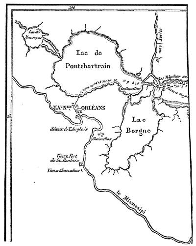
NEW ORLEANS AND THE MISSISSIPPI.
[This is a part of the “Carte de la Côte de la Louisiane, par M. de Sérigny en 1719 et 1720,” as given in Thomassy’s Géologie pratique de la Louisiane, 1860.—Ed.]
During the year 1721 the mortality of the immigrants on the passage over seriously affected the growth of the colony. Among other similar records it is reported that in March two vessels arrived, having on board forty Germans,—all that remained out of two hundred. The same month the “Africaine” landed one hundred and eighty negroes out of two hundred and eighty on board when she sailed, and the “Duc du Maine” three hundred and ninety-four out of four hundred and fifty-three. The pains of the poor creatures did not end with the voyage. Some of them “died of hunger and suffering on the sands of Fort Louis.” Enfeebled by the confinement and trials of a protracted ocean voyage, immigrants and slaves alike were landed on the beach at Biloxi, where neither suitable food nor proper shelter was furnished them.[59] Indeed, so great was the distress for food in 1721, that the very efforts put forth to increase the population were a source of embarrassment and suffering. There were not provisions enough left at Biloxi in September to maintain the garrison; and once again, after more than twenty years’ occupation by the French, the troops at Biloxi were dispersed among the Indians for subsistence.
The engineers who were watching the action of the Mississippi kept a record of their soundings. They attributed the changes which they observed to the scouring action of the water, and suggested methods[60] for keeping up the strength of the current by restraining the river within limits. Their observations confirmed Bienville in the opinion that New Orleans could be reached directly by vessel; thus avoiding the wretched anchorage, fifteen miles from shore,[61] and the expensive and troublesome transfer from ship to barge, and from barge to boat, only to effect a landing by wading, at a spot which was still several days of difficult travel from the natural highway of the country.
The news of the collapse of the Royal Bank and of the flight of Law reached the colony in June, 1721. The expectation that the troubles of the mother country would react upon the fortunes of the colony created great excitement; but the immediate result fell short of the anticipation. Affairs in the territory of Law’s concession were in great confusion. The Alsatians and Germans whom he had placed upon it, finding themselves neglected and the future of the grant doubtful, came down to New Orleans in the expectation of being sent back to Europe. The colony did not willingly relinquish its hold on any of its settlers. These industrious laborers, who had been imported to till the soil, were placated by the grant of concessions along the Mississippi at a point about twenty miles above New Orleans. By their skill in market-gardening they secured the control of that business in the little town which almost in spite of the Company had sprung up on the banks of the river. Bienville, supported by Pauger, one of the engineers, had for some time favored New Orleans as headquarters. The views of the Company on this point had fluctuated. In 1718 the instructions were, to try to open the river to vessels. In 1720 Ship Island, the Alibamons, and the Ouabache (Ohio) were the points they proposed to fortify. In 1721 Pauger prepared a plan for the proposed city of New Orleans. At that time there were only a few cabins there. It was necessary to cut down brush and trees to run the lines. Settlers were attracted by these proceedings, but jealousy stopped the work for a while. Charlevoix, who visited the place in 1722, says that the transfer of the stores of the Company from Biloxi to New Orleans began about the middle of June of that year.
The “Aventurier” arrived in the roadstead in the latter part of May, 1722, bringing orders to make New Orleans the principal establishment of the colony. She was taken up the river by the engineers La Tour and Pauger, and orders were given that all ships should thereafter enter the Mississippi. The “Aventurier” reached New Orleans July 7, and on the 5th of August the departure of Bienville from Biloxi for New Orleans is recorded.
Exchange and currency had proved to be serious drawbacks to the prosperity of Canada. Louisiana was destined to undergo a similar experience. Paper money and card money were issued by the Company. Arbitrary ordinances requiring the presentation of these bills for redemption within a stated time were suddenly promulgated. The price at which the silver dollar should circulate was raised and lowered by edict. Copper money was also forced into circulation. The “Aventurier” had some of this coin on board when she made her famous trip to New Orleans. It was imported, conformably to the edict of June, 1721. The inhabitants were enjoined to receive it without demur, as the Company would take it on the same terms as gold and silver.
To provide for the adjustment of disputes, the colony was divided into nine districts, and judicial powers were conferred upon the commanders of the districts. The jurisdiction of the Superior Council was made exclusively appellate. A similar appellate court, subordinate, however, to the Superior Council, was provided for Illinois.
By ordinance issued May 16, 1722, by the commissioners of the Council, with consent of the Bishop of Quebec, the province of Louisiana was divided into three spiritual jurisdictions. The first comprised the banks of the Mississippi from the Gulf to the mouth of the Ohio, and included the region to the west between these latitudes. The Capuchins were to officiate in the churches and missions of this district, and their Superior was to reside in New Orleans. The second district comprised all the territory north of the Ohio, and was assigned to the charge of the Jesuits, whose headquarters were to be in Illinois. The district south of the Ohio and east of the Mississippi was assigned to the Carmelites. The residence of their Superior was ordinarily to be at Mobile. Each of the three Superiors was to be a grand vicar of the Bishop of Quebec.
By ordinance of the Bishop of Quebec, issued Dec. 19, 1722, the district of the Carmelites was added to that of the Capuchins. The Carmelites then returned to France. In the month of December, 1723, the northern boundary of this district was changed to Natchez, and all the country north of that point, to the east and to the west, was put under charge of the Jesuits.
On the 27th of June, 1725, the Company, to allay the fears of the Capuchins, issued a new ordinance, in which they declared that the Capuchins alone should have the right to perform ecclesiastical functions in their district, and that no priest or monk of other brotherhood should be permitted to do so except with their consent. By request of the Capuchins, this was confirmed by patent from the King, dated the 25th of July, 1725.
The Capuchins had neither the numbers nor the influence essential for so great a work. For this reason the Company assigned the care of the French posts of the district to the Capuchins, and the charge of the Indian missions to the Jesuits; and an agreement was made, Feb. 26, 1726, with the Jesuit fathers, in which the latter undertook to furnish missionaries for the required work. In consequence of this arrangement it became necessary for the Jesuits to have an establishment in New Orleans. Permission to have such establishment was granted by the Company, on condition that they should exercise no ecclesiastical function except by consent of the Capuchins. Beaubois, the Jesuit Superior, disregarded this injunction, and undertook to override the Capuchins, who would have returned to France if he had not been recalled.
On the 13th of September, 1726, the Company entered into a contract with the Ursulines, in which the latter agreed to provide six nuns for the hospital and to educate the girls of New Orleans. The nuns, who were furnished in pursuance of this agreement, sailed from France Feb. 23, 1727. After a perilous voyage, five months in length, they arrived at New Orleans and at once entered on their work.
In 1724 the accumulated complaints of the several officers with whom Bienville had come into collision produced his downfall. La Harpe came to his rescue in a memorial upon the importance of the country and the necessity of maintaining the colony. Louisiana was not to be held responsible for frauds on the Company, nor for lack of system and bad management in its affairs. The Company itself had “begun by sending over convicts, vagrants, and degraded girls. The troops were made up of deserters and men indiscriminately picked up in the streets of Paris. The warehouses were openly robbed by clerks, who screened their knaveries by countless false entries. Disadvantageous bargains were made with companies of Swiss and Germans, of miners, and manufacturers of tobacco,[62] which turned out absolutely without value because the Company did not carry them out. A vast number of burdensome offices were created. The greater part of the directors who were sent out thought only of their own interests and of how they could thwart M. de Bienville, a man more familiar with the country than they were. If he proposed to bring ships up the river, they obstinately opposed him, fearing that they would then no longer be able to maintain traffic with the Spaniards and thus amass fortunes.” La Harpe’s interposition may have subsequently influenced opinions as to Bienville’s merits, but at the time it had no apparent result. In February, 1724, Bienville received positive orders to return to France. The brief interval which elapsed before he sailed gave him an opportunity to associate his name with the issue of the harsh and arbitrary code of fifty-four articles regulating the conduct of the unfortunate slaves in the colony, and imposing penalties for violations of law.
On his return to France, Bienville presented a memorial in vindication of his course. Eight years before this he had urged upon the Marine Council that he was entitled to promotion. The recapitulation of his services, with which he opened his letter, is used again in substance in the memorial: “For thirty-four years Sieur de Bienville has had the honor of serving the King, twenty-seven of them as lieutenant du roy and as commandant of the colony. In 1692 he was appointed midshipman. He served seven years as such, and made seven sea-voyages in actual service on armed vessels of the navy. During these seven years he participated in all the combats waged by his brother, the late Sieur d’Iberville, upon the shores of New England, at Newfoundland, and at Hudson’s Bay; and among others in the action in the North against three English vessels. These three vessels, one of which had fifty-four guns and each of the others forty-two, attacked the said Sieur d’Iberville, then commanding a frigate of forty-two guns. In a combat of five hours he sank the fifty-four-gun ship, and took one of the others; while the third, disabled, slipped away under cover of the night. The said Sieur de Bienville was then seriously wounded in the head.”[63] He then refers to his services in the exploring expedition and in the colony, closing with the statement that his father was killed by the savages in Canada, and that seven of his brothers died in the French naval service.
In support of his memorial, and to refute statements that there would be an Indian outbreak if he should return, several representatives of the Indian tribes of the colony, moved thereto by Bienville’s relatives, were admitted to an audience with the Superior Council, and there pronounced themselves friendly to him. It was thus that the red men, on whom he had relied for food at some time in nearly every year since he landed in Louisiana, rewarded him for his friendly interest in their behalf,—him who had been the advocate of the plan for exiling them to Santo Domingo, there to be exchanged for negroes; who had subdued the eight hundred warriors of the Natchez by treacherously seizing and holding their principal chiefs; who, on the 1st of February, 1723, wrote that an important advantage over the Chickasaws had been gained without the loss of a French life, “through the care that I took to set these barbarians against each other.”

All efforts of Bienville for reinstatement were thrown away. The Council were of opinion that much of the wrangling in the colony was due to the Le Moynes. M. Périer was appointed governor; and in order that his administration might have a fair chance, several of Bienville’s relatives were deprived of office in the colony. Under the new Government, events moved on as before. The quiet of colonial life was undisturbed except for the wrangling of the officials, the publication of company orders, and the announcement of royal edicts. In a memorial forwarded by the commander of Dauphin Island and Biloxi, a highly colored picture is shown of the chaotic condition of affairs. “The army was without discipline. Military stores and munitions of war were not protected. Soldiers deserted at pleasure. Warehouses and store-ships were pillaged. Forgers, thieves, and murderers went unpunished. In short, the country was a disgrace to France, being without religion, without justice, without discipline, without order, and without police.”
Bienville had steered clear of serious Indian complications. He had settled by deceit, without a blow and almost without troops, what in place of more stirring events had been called the “first war of the Natchez.” On the occasion of a second collision, in 1723, he had simply appeared upon the scene with a superior force, and dictated terms to the natives. During Périer’s term of office signs of uneasiness among the natives and of impending trouble began to show themselves. Warnings were given to several of the inhabitants of Natchez that danger was to be apprehended from the neighboring tribe. The commander of the post wilfully neglected these warnings, which were repeatedly brought to his knowledge. On the 29th of November, 1729, the Natchez Indians rose, and slaughtered nearly all the male inhabitants of the little French village.[64] The scene was attended with the usual ingenious horrors of an Indian massacre. A prolonged debauch succeeded. The Yazoos, a neighboring tribe, surprised and slaughtered the little garrison which held the post in their country. Even the fathers in charge of the spiritual affairs of the posts were not spared.[65] Except for this uprising of the Yazoos, the example of the Natchez tribe was not contagious. News was quickly conveyed up and down the river, and but little damage happened to travellers between Illinois and Louisiana.
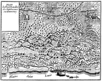
FORT ROSALIE.
[“Plan du Fort Rozalie des Natchez,” in Dumont’s Mémoires historiques de la Louisiane, ii. 94. There is also a plan of Fort Rosalie in Philip Pittman’s Present State of European Settlements on the Mississippi (London, 1770), p. 40.—Ed.]
According to Dumont, the Choctaws and Natchez had conspired to attack the French simultaneously at New Orleans and Natchez, and the attack at Natchez was made in advance of the day agreed upon for the outbreak. At this, he says, the Choctaws were exasperated, and announced that they were willing to move in conjunction with the French upon Natchez. According to their own professions, however, their friendship for the French was uninterrupted, and they denied any previous knowledge of the outbreak at Natchez. Whatever the motive which prompted it, a joint military campaign against the Natchez was now organized with the Choctaws. All the credit in the affair was gained by the Indians. They were first in the field, and they did all the open fighting. When the French tardily arrived on the spot, instead of the surprise, the sudden attack, the rapid flight, and the complete victory or defeat which had hitherto characterized most Indian warfare, they found the Natchez behind rude fortifications, within which they had gathered all their people, together with the women and children captured at the recent attack on the village. The French were compelled to approach these defences with all the formalities of a siege. At the end of what Périer bombastically terms “six days of open trenches and ten days of cannonade,” the Natchez on the 26th of February, 1730, surrendered the captive women, children, and slaves to the Choctaws, withdrew their entire force, and fled to the opposite bank of the Mississippi. The knowledge that the French captives were with the Indians probably hampered the French in their attack.
The services of tribes friendly to the French were secured during the summer to harass the miserable Natchez; and on the 1st of August the Governor could proudly report that by this means he had been able since their migration to kill a hundred and fifty. “Lately,” he says in one of his despatches, “I burned four men and two women here, and the others I sent to Santo Domingo.” Smarting under the disgrace cast upon their reputation by the fruitless results of this campaign, the French felt the necessity for subduing the fugitive Natchez, who still preserved their tribal organization and their independence. An alleged negro insurrection the next summer furnished opportunity for hanging “ten or a dozen of the most culpable” of the negroes, and further demonstrated the necessity for some attempt to recover the prestige of the French name.
In the month of November, 1730, Périer started on a crusade against his foes. The force which he ultimately brought together for this expedition is said to have been a thousand men, of whom seven hundred were French. In January, 1731,[66] he succeeded in running down the Natchez in their fort, situated a short distance from the river on the west side, where he besieged and finally captured—according to his own account—four hundred and fifty women and children and forty-five men. Again the greater part of the warriors of the tribe escaped him. The captives were sent to Santo Domingo, where they were sold as slaves.
The resources of the colony were now better understood. Buffalo-wool, pearls, and mines were no longer relied upon. Prosperity had eluded the grasp of the greater part of the settlers; but if agricultural experiments had not proved remunerative as they had been handled, they had at least demonstrated the fertility of the soil. The hopes of commercial success, with so scant a population and under the restrictions of the monopoly, were shown to be delusive. The climate had proved a severe trial to the health of the settlers.[67] Perhaps the character of the immigrants, their improvident habits, and their reckless exposure had much to do with it, and had made the test an unfair one. At all events the experience of the Company was but a repetition of that of Crozat; and in 1731 the rights granted in the charter were surrendered to the King. During Périer’s administration a change was made in the character of the girls sent over to the colony. In 1728 there arrived a ship bearing a considerable number of young girls who had not been taken from the houses of correction. They were cared for by the Ursulines until they were married.
It is not easy to follow the growth of the colony. When Crozat turned matters over to the Company, there were said to be seven hundred inhabitants; but four years afterward the Company officials, in one of their reports, put this number at four hundred. The official estimate in 1721 was five thousand four hundred and twenty, of whom six hundred were negroes. La Harpe, in his memorial, puts the population in 1724 at five thousand whites and three thousand blacks. At the time of the retrocession to the King the white population was estimated at five thousand, and the negroes at over two thousand.
The treasury notes of the Company at that time constituted the circulating medium of the colony. Fifteen days were allowed, during which their use could be continued. After that their circulation was prohibited, with appropriate penalties.
The Government signalized its renewal of the direct charge of the colony by efforts to build up its commerce. Bienville succeeded in securing his appointment as governor, and in 1733 returned to Louisiana. The finances of the colony having undergone the disturbance of the withdrawal of the paper money of the Company, the Government consulted the colonial officers as to issuing in its place some card money. These gentlemen recommended that the issue should be postponed for two years. The impatience of the Government could, however, be restrained but a year, when the entering wedge of two hundred thousand livres was ordered,—the beginning of more inflation. In 1736 Bienville, owing to the unfriendly attitude of the Chickasaws, felt the necessity of success in some movement against them, if he would retain the respect and friendship of the Choctaws. He therefore made an imposing demonstration against the Chickasaw villages. According to his own account, he had with him over twelve hundred men, who in an attack on one of the villages were repulsed with such severe loss that the whole party were glad to get back to the shelter of their permanent forts, without the satisfaction of knowing that they had either killed or wounded one of the enemy.
The Chickasaws had apparently learned the value of earthworks as defences, from their experience, if not from the English traders. Some of these traders were in the village at the time of the attack, and hoisted the English flag over their cabins. By throwing up the earth around their houses, the Indians had converted each habitation into a fortification. Unfortunately for the objects of the expedition, Bienville learned, on his return to Mobile, that a coöperating column, organized in Illinois, and composed mainly of Northern Indians, which had marched under young Artaguette against the same enemy, had been completely worsted, and their leader was reported killed.
If the movement against the Chickasaws was demanded by the condition of affairs before this demonstration, the repulse made a renewal of it at an early day a positive necessity. A strong force of men was sent over from France under an officer trusted by the Court, and in 1739 an advance was made with twelve hundred white soldiers and twenty-four hundred Indians, by way of the Mississippi instead of the Tombigbee. They were joined at a point near the present site of Memphis by a company under Céloron, and by a detachment from Fort Chartres under Buissonière. Five months were consumed in exploring a road which was supposed to have been already laid out before they started. During this time all the provisions of the expedition were consumed, and the main army was obliged to return without having seen the enemy. The extensive preparations for the expedition had, however, a moral effect. In March a company of Canadians and Northern Indians, which had reported at the appointed rendezvous, penetrated alone to the Chickasaw villages. The chiefs of that tribe, believing that this corps was supported by the expedition, sued for peace, which the French gladly granted them.
Every military effort put forth by Bienville since his return to Louisiana had resulted disastrously. The old story of accusation and counter-accusation between the resident officials of the colony continued during his second term as before. Chagrined at his lack of success, and mortified by evident distrust of his abilities shown by the Court, he tendered his resignation and pathetically wrote: “If success proportionate to my application to the business of the Government and to my zeal in the service of the King had always responded to my efforts, I should gladly have consecrated the rest of my days to this work; but a sort of fatality has pursued me for some time, has thwarted the greater part of my best-laid plans, has often made me lose the fruit of my labors, and perhaps, also, a part of the confidence of Your Highness.” On the 10th of May, 1743, he was relieved by the Marquis de Vaudreuil, and he then returned to France. He was at that time sixty-two years of age, and never revisited the scene of nearly forty-four years of active life in the service of the Government. He was called the “Father of the Colony,” and a certain romantic affection attaches to his memory, based rather upon his professed good-will than upon any success shown in his management of affairs.
During the remainder of the life of the colony, under the administration of M. de Vaudreuil until he was called to Canada, and after that under M. de Kerlerec, his successor, there was no material change in the condition of affairs. All attempts at recapitulation of events resolve themselves into dreary reiterations of what has already been told again and again. Tobacco and rice continued to be the staple products of the colony. Hopes were still maintained that something might be made by cultivating the indigo-plant. The sugar-cane was introduced in 1751.
There was more of tampering with the currency. Incredible as it may seem, there was scarcity of provisions at this late day, and appeals to France for food.[68] The friendly Choctaws were again incited to war against their traditional enemies, the Chickasaws, and strife was also stirred up among themselves. Another warlike expedition boldly marched to the Chickasaw villages and came back again. Criminations and recriminations between governor and commissaire-ordonnateur continued to the end, with few intermissions and with as lively a spirit as characterized the fiercest days of Bienville’s chronic fights. There was another shipment of girls as late as 1751. The character of the troops remained as before, and deserters continued to be a source of annoyance. Even the children of the colonists were affected by their surroundings, if we may believe an anonymous writer,[69] who says, “a child of six years of age knows more of raking and swearing than a young man of twenty-five in France.”
Illinois, separated from the cabals of the little courts at Quebec and New Orleans, showed some signs of prosperity.[70] In 1711 Father Marest wrote: “There was no village, no bridge, no ferry, no boat, no house, no beaten path; we travelled over prairies intersected by rivulets and rivers, through forests and thickets filled with briers and thorns, through marshes where we plunged up to the girdle.” The character of the returns expected by the French from this country had been shown by the expeditions of Le Sueur and La Mothe Cadillac. A few boat-loads of green earth had been sent to France by Le Sueur for assay, but no mines were opened. La Mothe brought down a few specimens of silver ore which had been found in Mexico, and some samples of lead from the mines which were shown him fourteen miles west of the river; but he discovered no silver mines. Nevertheless, the Company had great faith in this region. Their estimate of the dangers to which it was exposed may be gathered from the instructions to Ordonnateur Duvergier in the fall of 1720. He was told where the principal fortifications were to be maintained. Illinois, the directors said, being so far inland, would require a much smaller fort. Communication was to be opened up with that post by land. Positive commands were given to hold a post on the Ohio River, in order to occupy the territory in advance of the English, and prevent them from getting a foothold there. “Illinois is full of silver, copper, and lead mines, which ought to produce considerable returns if worked. The Company has sent to the colony a number of miners to open the mines and to begin work there as an example to the owners of concessions and to the inhabitants. The troop of Sieur Renault, composed of people accustomed to work of this sort, went to the colony at the same time; but the two troops, according to last reports, are not yet at Illinois.”
About the same time it was ordered that “the establishment made by Boisbriant,” originally a few leagues below the village of the Kaskaskias, but apparently afterward transferred to a point about the same distance above the village, should be “called Fort de Chartres.”[71]
In 1721 Charlevoix traversed this region. Speaking of the so-called fort at St. Joseph, near the foot of Lake Michigan, he says: “The commandant’s house, which is but a sorry one, is called a fort from its being surrounded with an indifferent palisade,—which is pretty near the case with all the rest.” The route of Charlevoix was up the St. Joseph across a portage to the Kankakee, and down that river, the Illinois, and the Mississippi, to Fort Chartres, the next French station which he mentions.[72] He describes it as standing about a musket-shot from the river. He heard of mines both copper and lead. Renault, or Renaud, as he is generally called, who was working the lead mines, still hoped for silver. Even after this we hear occasionally of alleged mineral discoveries and revived hopes of mines; but neither the Company nor the Government were destined to reap any great revenue from this source.
The duties of Boisbriant and of his successors were almost exclusively limited to adjudicating quarrels, administering estates, watching Indians, and granting provisional titles to lands or setting off rights in the common fields of the villages. The history of these years is preserved in fragments of church-registers, in mouldy grants of real estate, or in occasional certificates of marriage which have by chance been saved. No break occurred in this monotony till the joint movement against the Chickasaws, of young Artaguette from Fort Chartres and of Vinsennes from his post on the Wabash in 1736. The troops from these posts, who were to move from the North at the same time that Bienville should approach from the South, following their orders, met and advanced at the appointed time. Their prompt obedience brought them to the spot in advance of the dilatory Bienville, and enabled the Chickasaws, as has been previously stated, to meet the columns separately and defeat them in detail. A column from this fort was also in the body of troops from the North which co-operated in the second attack on these Indians.
During this uneventful time the little colony grew, and the settlers enjoyed a moderate degree of prosperity. A contented population of about two thousand whites,[73] to whom grants of land had been freely made for purposes of settlement or cultivation, was mainly engaged in agricultural pursuits. Side by side with them the natives were gathered in villages in which were established Jesuit missions. The fertile soil readily yielded to their efforts at cultivation more than they could consume, and each year the surplus products were floated down to New Orleans. Bossu asserted that all the flour for the lower country came from Illinois. Vaudreuil, before leaving the colony for Canada, reported[74] that boats came down the river annually with provisions; but as late as 1744 he still harped on the discovery of new copper and lead mines. Of the real agricultural value of the country there could not at that time have been any just appreciation. As a mining region it had proved to be a failure.
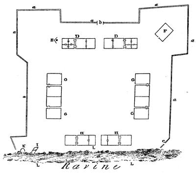
PLAN OF FORT CHARTRES.
[Taken from Lewis C. Beck’s Gazetteer of the States of Illinois and Missouri, (Albany, 1823). The plan was draughted from the ground in 1823. Key: a,a,a, etc., exterior wall (1447 feet); B, gate; C, small gate; D,D, houses of commandant and commissary, 96×30 feet each. E, well; F, magazine; G,G, etc., barracks, 135×36 feet; H,H, storehouse and guard-house, 90×24 feet. I, small magazine; K, furnace; L,L, etc., ravine. Area of fort, 4 acres.—Ed.]
The little fort needed repairs;[75] and La Galissonière, with his usual sagacity, wrote, “The little colony of Illinois ought not to be left to perish. The King must sacrifice for its support. The principal advantage of the country is its extreme productiveness; and its connection with Canada and Louisiana must be maintained.” Apparently the urgency of La Galissonière produced some results. Macarty, the officer who had command of the post at the time of the collision between the French and the English at the headwaters of the Ohio, arrived at Fort Chartres in the winter of 1751-1752. Bossu, who accompanied him, writes from the fort: “The Sieur Saussier, an engineer, has made a plan for constructing a new fort here, according to the intention of the Court. It will bear the same name with the old one, which is called Fort de Chartres.” In January, 1755, Bossu arrived a second time at the post, having in the mean time made a trip to New Orleans. He says: “I came once more to the old Fort Chartres, where I lay in a hut till I could get a lodging in the new fort, which is almost finished. It is built of freestone, flanked with four bastions, and capable of containing a garrison of three hundred[76] men.” The construction of this fort was the final effort of France in the Valley of the Mississippi. It proved to be of even less value than the fortress at Louisbourg, upon which so much money was wasted, for it fell into the hands of the enemy without the formality of a siege. On the other side of the river, Bournion, who in 1721 bore the title of “Commandant du Missouri,” founded Fort Orleans on an island in the Missouri, and left a garrison[77] there, which was afterward massacred. Misère, now known as St. Genevieve, was founded about 1740.
As events drifted on toward the end of the French occupation, the difficulties of the French Government elsewhere compelled the absolute neglect of Louisiana. Kerlerec writes in 1757 that he has not heard from the Court for two years; and in 1761 the French ambassador, in a memorial to the Court at Madrid, states that for four years no assistance had been furnished to the colony. An estimate of the population made in 1745 places the number of inhabitants at six thousand and twenty, of whom four thousand were white. Compared with the number at the time of the retrocession by the Company, it shows a falling off of a thousand whites. It is probable that the white population was even less at a later day. It is not strange that the feeble results of this long occupation should have led the Most Christian King to the determination to present the colony to his very dear and much-loved cousin, the King of Spain,—an act which was consummated in 1762, but not made public at the time. Its influence was not felt until later.
The outline of events in Canada which we have previously traced carried us to a point where the first collision in the Valley of the Ohio between the troops of the two great nations who were contending for the mastery of the northern portion of the continent had already taken place. News of this contest reached New Orleans, and reports of what was occurring at the North served to fill out the Louisiana despatches. From this source we learn that the Chevalier de Villiers,[78] a captain stationed at Fort Chartres, solicited the privilege of leading an expedition to avenge the death of his brother Jumonville, who had been killed by the Virginian force under Washington. The request was granted; and thus the troops from the East and from the West participated in these preliminary contests in the Valley of the Ohio.[79]
It is not within the proposed limits of this sketch to follow in detail the military events with which each of the few remaining years of French domination in America were marked. The death-struggle was protracted much longer than could have been anticipated. The white population of the English colonies is said to have been over ten times greater than that of Canada in 1755; and yet these odds did not fairly express the difference between the contending Powers.[80] The disproportion of the aid which might be expected from the mother countries was far greater. The situation was the reverse of what it had been in the past. England began to show some interest in her colonies. She was prosperous, and the ocean was open to her cruisers. The French experiments at colonization in America had proved a source of expense so great as to check the sympathy and crush the hopes of the Court. The vessels of France could only communicate with her colonies by eluding the search of the English ships widely scattered over the sea. Although no formal declaration of war was made until 1756, England did not hesitate to seize French merchant-vessels and to attack French men-of-war, and she backed the pretensions of her colonists with solid arguments clad in red coats and bearing glittering bayonets. France shipped a few soldiers and some stores to Canada. Some of her vessels succeeded in running the gauntlet of the English cruisers, but more were driven ashore or captured. The native Canadians, more French than Frenchmen themselves, rallied to the support of the Government which had strangled every sign of independent life in their country. Old men and children joined the ranks to repel the invader; and again we have the story repeated of scant crops improperly harvested because of lack of field hands, and thereafter actual suffering for food in this old and well-established colony. The experiences of Braddock and of Dieskau were needed to teach Europeans the value of the opinions of provincial officers in matters of border warfare. Temporary successes during several years inspired hopes in the minds of the French and thwarted the progress of the English. Nevertheless, the strength of the English began to tell, especially along the seaboard, where their supremacy was more conspicuous. The line of French forts across the neck of the Acadian peninsula fell without serious opposition, and it was determined to remove from the country a population which would neither take the oath of allegiance to His Britannic Majesty, nor preserve neutrality in time of war. Their forcible deportation followed; and in their wanderings some of these “neutral French” even penetrated to the distant colony of Louisiana, where they settled on the banks of the Mississippi.[81] Such was the demoralization of the official class of peculators in Canada that those refugees who escaped to the protection of its Government were fed with unwholesome food, for which the King had been charged exorbitant prices by his commissaries. The destruction of the fort at Oswego postponed for that year the efforts of the English to interrupt the communication between the valleys of the Ohio and the St. Lawrence. The destruction of Fort William Henry temporarily protected Montreal; the check sustained by Abercromby was of equal military value. But in 1758 Louisbourg, with its garrison and stores was lost, the little settlements in Gaspé were ravaged, and France was deprived of the last foot of territory on the North Atlantic seaboard. Quebec thus became accessible to the enemy by way of the sea without hindrance.

Distrust and jealousy pervaded the Government councils in Canada. Pierre François, Marquis of Vaudreuil, the successor of Duquesne in 1755, and Montcalm, whose cordial co-operation was essential, were at swords’ points. With each succeeding year the corrupt practices of Intendant Bigot were more openly carried on. With famine stalking through the streets of Montreal and Quebec, with the whole population living on short rations, and bread-stuffs at incredible prices, the opportunity for this wide-awake Intendant to make money was never better. If accounts are to be trusted, he availed himself of his chance; and out of the sufferings and dire necessities of this sorely pressed people he amassed a fortune.[82] All this was to the advantage of England. Every point that she gained in the struggle she kept. From each reverse that she sustained she staggered up, surprised that the little band of half-starved Canadian troops should have prevailed again, but with renewed determination to conquer. The only value of success to Canada was to postpone the invasion, and for the time being to keep the several columns which threatened Montreal from co-operation. With so feeble a force the French could not hope to maintain the widely scattered forts which they held at the beginning of hostilities. In 1759 they were threatened by hostile columns counting more than the entire number of Canadians capable of bearing arms. All hope of aid from France was crushed by the Minister, who wrote: “In addition to the fact that reinforcements would add to the suffering for food which you already experience, it is very much to be feared that they would be intercepted by the English on passage.” Such was the mournful condition of affairs when Wolfe sailed up the St. Lawrence, expecting to find Quebec ready to fall into his hands. To his surprise, the place was held by a force thoroughly capable of defending it against the combined strength of his soldiers and sailors. Fortune favored him, and Quebec was gained.
The resistance of the French during one more campaign was probably justifiable, but was a mere matter of form. Without hope of assistance from France, without means of open communication with any other French possession, without supplies of ammunition or of food, there was really nothing left to fight for. Even the surrounding parishes of Canada had yielded to the pressure of events, after the failure to recapture Quebec. When, therefore, the English columns converged upon Montreal in 1760, the place capitulated, and the French flag disappeared from Canada.
At the mouth of the Mississippi French occupation was not disturbed until the boundaries were adjusted in accordance with the terms of the Treaty of Peace signed at Paris in February, 1763. No reference was made in the treaty nor in the preliminary convention to the fact that France had already granted to Spain her title to the whole of Louisiana. Knowledge of this remarkable act was kept secret for a few years longer. England, by the terms of the treaty of Paris, became the acknowledged mistress of all that portion of the American continent which lies east of the middle of the Mississippi River, with the exception of the island on which was built the city of New Orleans. Ample provision was made to protect the rights of French citizens who might wish to remove from the country. The privilege of religious worship according to the forms of the Roman Catholic Church was guaranteed to those who should remain, as far as the laws of England would permit.
The era of colonial history which this chapter covers is coincident with a period of decline in France. The transmission of the throne in the line of descent was not, however, interfered with, nor were the traditions of colonial policy changed. The causes of the rise and fall of the colonies of European Powers at that time are to be found in the history of European politics; and European politics in turn were largely influenced by the desire to control territory in the New World. The life of French colonies was in close contact with European events. If the pulse of the English settlements did not throb in such sympathy with the mother country, it was because there was a fundamental difference in the methods by which English colonies had been formed and in the conditions of their growth. A colony was not looked upon at that time as forming a part of the parent State. It was a business venture, entered into directly by the State itself, or vicariously by means of a grant to some individual or company. If the colony did not earn money, it was a failure. Spain had derived wealth from ventures of this sort. Other nations were tempted into the pursuit of the same policy in the hope of the same result.
To preserve the proper relations to the parent State, the colony should have within itself elements of wealth which should enrich its projectors; it should absorb the productions of the State which founded it; and in no event ought it to come into competition with its progenitor. The form of the French government was so logical that its colonies could be but mimic representations of France. Priests and nuns, soldiers and peasants, nobles and seigniors, responded to the royal order, and moved at the royal dictation in the miniature Court at Quebec much the same as at Paris. There was so little elasticity in French life that the French peasant, when relieved from the cramp of his surroundings, still retained the marks of pressure. Without ambition and without hope, he did not voluntarily break away from his native village. If transported across the water, he was still the French peasant, cheerful in spirit, easily satisfied, content with but little, and not disposed to wrestle for his rights. The priest wore his shovel-hat through the dense thickets of the Canadian forests, and clung to his flowing black robe even though torn to a fringe by the brambles through which it was trailed. Governor and council, soldier, priest, and peasant, all bore upon their persons the marks that they were Frenchmen whose utmost effort was to reproduce in the wilds of America the artificial condition of society which had found its perfect expression in Versailles. Autocratic as was Frontenac, unlikely as he was to do anything which should foster popular notions of liberty, or in any way endanger monarchical institutions,—even he drew down upon himself a rebuke from the Court for giving too much heed to the people in his scheme of reorganization.
From his palace in France the Grand Monarque dictated the size and shape of a Canadian farm. He prescribed the localities which new-comers ought to select. They must not stray too far from villages; they must clear lands in spots contiguous to settlements. He could find men who would go to Canada, but there was no emigration of families. Soldiers in the colony were offered their discharge and a year’s pay if they would marry and settle. Premiums were offered the colonists for marrying, and premiums for children. “The new settler,” says Parkman, “was found by the King, sent over by the King, and supplied by the King with a wife, a farm, and sometimes with a house.” Popular meetings were in such disfavor that not until 1717 were the merchants permitted to establish an exchange at Quebec. His Majesty, while pulling the wires which moved the puppets of European politics, still found time to express his regrets that the “King’s officers had been obliged to come down from Frontenac to Quebec to obtain absolution,” and to convey his instructions to the Bishop of Quebec to suppress several fête-days which interfered with agricultural labors. Cared for thus tenderly, it would seem that Canada should have thriven. Had the measures put forth been wisely directed toward the prosperity of the colony, it might have done so; but Louis XIV. was not working for the benefit of Canada; his efforts were exclusively in behalf of France. In 1706 his Minister wrote: “It is not for the interest of the parent State that manufactures should be carried on in America, as it would diminish the consumption of those in France; but in the mean time the poor are not prohibited from manufacturing stuffs in their own houses for the relief of themselves and their families.” Generous monarch! The use of the spinning-wheel and the loom was not forbidden in the log-cabins in Canada, even if this did clash somewhat with French trade. “From this permission,” says Heriot, “the inhabitants have ever since continued to fabricate coarse linen and druggets, which has enabled them to subsist at a very small expense.” Coin was almost unknown much of the time; and the paper money and bills of exchange, upon which the colony depended for a circulating medium, were often seriously depreciated.
The spirit of organization and inquisition which infested the Government pervaded all things temporal and spiritual. Trade in peltries could only be carried on by those having permits from the Government or from the firm or company which for the time being had the monopoly. All trade at outlying posts was farmed out by the governors. Young men could not stray off into the woods without violating a royal edict. Such solicitude could only produce two results,—those who endured it became automatons; those who followed their inclinations and broke away from it were proscribed as bushrangers. From the day when Champlain founded the city of Quebec down to the time when the heroic Montcalm received his death-wound on the Plains of Abraham, the motives which had influenced the French in their schemes of colonization had been uniform and their methods identical. Time enough had elapsed to measure the success of their efforts.
French colonization in America had reached three degrees of prosperity. In Acadia, under English rule, freed from military service in the ranks of the country to which they naturally owed allegiance, and with their rights as neutrals recognized by the English, the French colonists had prospered and multiplied. Originally a band of hunters and fishers, they had gradually become an agricultural population, and had conquered prosperity out of a soil which did not respond except to the hand of patience and industry. Exempt from the careful coddling of His Most Christian Majesty, they had evoked for themselves a government patriarchal in its simplicity and complete for their needs. In Louisiana, under the hothouse system of commercial companies and forced immigration, the failure had been so complete that even those who participated in it could see the cause. In Canada there was neither the peaceful prosperity of Acadia nor the melancholy failure of Louisiana. Measured by its own records, the colony shows steady growth. Compared with its rivals, its laggard steps excite surprise and demand explanation. The Acadians were French and Catholics. Neither their nationality nor their religion interfered with their prosperity. They had, however, been lucky enough to escape from the friendly care of the French Government. It is but a fair inference that the Canadians also would have thriven if they could have had a trial by themselves.
The history of England during the corresponding period showed no such uniform motive, no such continuous purpose as to her colonies. From the time of their foundation the English colonies became practically independent States, with which the Home Government, during the long period of political disturbances which intervened, seldom interfered. The transmission of the crown by descent was interrupted. A parliament displaced and executed a king. A protector temporarily absorbed his power. The regular order of the descent of the crown in the restored royal family was again interrupted. The crowned ruler of England was a fugitive on the Continent, and Parliament by act prescribed who should govern England, and afterward how the crown should be transmitted. The causes that produced English emigration, whether political or religious, varied with these events, and emigration was correspondingly affected; but whatever the extent and whatever the character of this influence, the emigration from England was, as a rule, a voluntary emigration of families. Young men might be tempted by the fascinating freedom of a wild life in the woods; but the typical emigrant was the father of a family. He abandoned a home in the old country. He took with him his wife, his family, and his household goods. Much of the furniture brought over by the sturdy emigrants of that time is still treasured by their descendants. The strong mental individuality which thus led men with families to cut adrift from the struggles and trials in England, only to encounter the dangers and difficulties of pioneer life in a new country, found expression in various ways in the affairs of the colonies, oftentimes to the vexation of the authorities.
The New France was a reproduction of the Old France, with all, and more than all, the restrictions which hampered the growth and hindered the prosperity of the parent State. The New England had inherited all the elements of prosperity with which the Old England was blessed, and had even more of that individuality and freedom of action on the part of its citizens which seems to form so important an element of success. Out of the heterogeneous mixture of proprietary grants, colonial charters, and commissions, some of which were granted to bodies which sought exclusive privileges, while others were based upon broad, comprehensive, and liberal views; out of the conflicting interests and divergent opinions of fugitive Congregationalists, Quakers, and Catholics; out of a scattered, unorganized emigration of men entertaining widely different views upon politics and religion,—these aggressive, self-asserting colonists evolved the principle of the right of the inhabitants to a voice in the affairs of their government; and whether provision was made for it in the charter or not, houses of burgesses, general courts, and assemblies were summoned to make laws for the various colonies. Charters were afterward annulled; laws which contained offensive assertions of rights were refused the royal assent: but the great fundamental truth remained,—that the colonies were self-supporting. They had proved their capacity, and they constantly showed their determination, to govern themselves. Each movement of the emigrant away from the coast became a permanent settlement which required organization and control. Out of the unforeseen and unexpected conditions which were constantly occurring came the necessity for local government, to be administered by officers chosen by the little settlements.
Emerson, in speaking of the first tax assessed upon themselves by the people of Concord in Massachusetts, accounts for the peculiar developments of colonial life in New England in the following words: “The greater speed and success that distinguishes the planting of the human race in this country over all other plantations in history owe themselves mainly to the new subdivisions of the State into small corporations of land and power. It is vain to look for the inventor; no man made them. Each of the parts of that perfect structure grew out of the necessities of an instant occasion; the germ was formed in England.”
The pioneer penetrated the forest; he took with him the school-house and the church. Out of the necessities of instant occasions grew, in New England at least, the town-meeting,—the complete expression of a government whose foundations are laid in the people.
Before leaving the colony, in 1754, the Marquis Duquesne summoned the Iroquois to a council. In the course of an address which he then delivered he said: “Are you ignorant of the difference between the King of England and the King of France? Go, see the forts that our King has established, and you will see that you can still hunt under their very walls. They have been placed for your advantage in places which you frequent. The English, on the contrary, are no sooner in possession of a place than the game is driven away. The forest falls before them as they advance, and the soil is laid bare so that you can scarce find the wherewithal to erect a shelter for the night.” No more powerful contrast of the results in North America of the two methods of colonization could be drawn than is presented in the words of the French Governor.

CRITICAL ESSAY ON THE SOURCES OF LOUISIANA HISTORY.
CHARLEVOIX’ Nouvelle France[83] and the account of his personal adventures in the Journal d’un voyage, etc., have been much quoted by early writers. The extent and value of Dr. Shea’s work in annotating his translation of this history can only be appreciated by careful study. Through this means the translation is more valuable for many purposes of research than the original work.[84]

In 1831 the Journal historique de l’établissement des Français à la Louisiane was published at New Orleans and at Paris. It consists of an anonymous historical narrative, to which is appended a memorial signed by Benard de La Harpe. It is generally quoted as “La Harpe.” The narrative is founded largely upon the journals of Le Sueur and La Harpe, though it is evident that the author had other sources of information. Within its pages may be found a record of all the expeditions despatched by the colony to the Red River region and to the coast of Texas.[85] The work of compilation was done by a clear-headed, methodical man. Margry quotes from the work, and attributes its authorship to “le Chevalier de Beaurain, géographe du roy.”[86] Manuscript copies of this work, under the title Journal historique concernant l’établissement des Français à la Louisiane, tiré des mémoires de Messieurs D’Iberville et De Bienville, commandants pour le roy au dit pays, et sur les découvertes et recherches de M. Benard de la Harpe, nommé aux commandement de la Baye St. Bernard, are to be found in some of our libraries.[87]
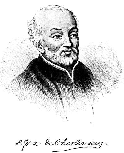
Following the engraving in Shea’s Charlevoix, vol. i. [but now, 1893, thought to be Le Jeune].
The historians of Canada give but brief and inaccurate accounts of the early history of Louisiana. Ferland repeats the errors of Charlevoix even to the “fourth voyage of Iberville.” Garneau leaves the Natchez in possession of their fort at the end of the first campaign.[88]
Judge François-Xavier Martin, in the History of Louisiana from the Earliest Period, 2 vols. (New Orleans, 1827-1829), followed closely the authorities accessible to him when he wrote; his work is a complete, and in the main accurate, compendium of the materials at his command. A new edition was published at New Orleans in 1882, entitled: The History of Louisiana from the Earliest Period. With a Memoir of the Author by W. W. Howe. To which is appended, Annals of Louisiana from 1815 to 1861, by J. F. Condon.
Charles Gayarré is the author of two distinct works which must not be confounded. Louisiana, its Colonial History and Romance,[89] is a history of colonial romance rather than a history of the colony. The Histoire de la Louisiane[90] is an essentially different book. It is mainly composed of transcripts from original documents, woven together with a slender thread of narrative. He states in his Preface that he has sought to remove from sight his identity as a writer, and to let the contemporaries tell the story themselves. References to Gayarré in this chapter are exclusively made to the Histoire, which was brought down to 1770. His final work (reprinted in 1885) was in English, and was continued to 1861.[91] In this edition two volumes are given to the French domination, one to the Spanish, and one to the American.[92]

A little volume entitled Recueil d’arrests et autres pièces pour l’établissement de la compagnie d’occident was published in Amsterdam in 1720. It contains many of the important edicts and decrees which relate to the foundation and growth of this remarkable Company.
The presence of Le Page du Pratz in the colony for sixteen years (1718 to 1734) gives to his Histoire de la Louisiane[93] a value which his manifest egotism and whimsical theories cannot entirely obscure. It was an authority in the boundary discussions.[94]
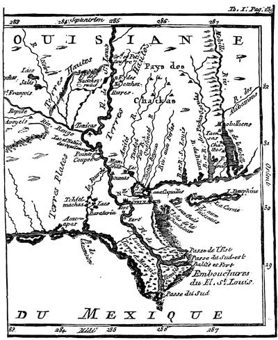
MOUTHS OF THE MISSISSIPPI.
[Part of a map in Le Page du Pratz’ Histoire de la Louisiane (1758), i. 139. Cf. also the Carte des embouchures du Mississipi, by N. Bellin, given (1744) in Charlevoix’ Nouvelle France, iii. 442. In the same volume (p. 469) is the “Partie de la coste de la Louisiane et de la Floride,” giving the coast from the mouths of the Mississippi to Apalache Bay. In 1759 Jefferys gave in the margin of his reproduction of La Tour’s map of New Orleans a map of the Mississippi from Bayagoula to the sea, and of the east mouth of the river, with the fort La Balise.—Ed.]
Dumont, whose Mémoires historiques sur la Louisiane[95] were edited by M. L. Le M. (said to have been L’Abbé Le Mascrier), was in the military service in the colony. In the Journal historique, etc., mention is made of a sub-lieutenant Dumont de Montigny[96] at the post at Yazoo. The author was stationed at this post, and accompanied La Harpe up the Arkansas. The statement made in biographical works that Butel Dumont,[97] who was born in 1725, was the author, is manifestly incorrect. Both Dumont and Le Page were contributors to the Journal œconomique, a Paris periodical of the day. We are able positively to identify him as Dumont de Montigny, through an article on the manner in which the Indians of Louisiana dress and tan skins, in that journal, August, 1752. Dumont had a correspondence with Buache the cartographer[98] on the subject of the great controversy of the day,—the sea of the west and the northwest passage. Dumont was fond of a good-sounding story;[99] and his book, like that of Le Page depends for its value largely upon the interest of his personal experiences. Another book of the same class is the Nouveaux voyages aux Indes occidentales,[100] by M. Bossu. The author, an army officer, was first sent up the Tombigbee, and afterward attached to the forces which were posted in Illinois, and was there when Villiers marched on Fort Necessity. He was in the colony twelve years, and bore a good reputation.
The work entitled État présent de la Louisiane, avec toutes les particularités de cette province d’Amérique, par le Colonel Chevalier de Champigny (A la Haye, 1776), has been generally quoted as if Champigny were the author. In an editorial introduction Champigny says the text and the notes were furnished him in manuscript by an English officer. In the body of the work the statement is made by the author that he accompanied the English forces which took possession of the colony after its cession to England. This work is cited by Mr. Adams in the boundary discussion.
The Mémoire historique et politique de la Louisiane, by M. de Vergennes, minister of Louis XVI. (Paris, 1802), contains a brief historical sketch of the colony, intended only for the eye of His Majesty. Its wholesome comments on the French troops and on French treatment of the Indians are refreshing to read.[101] They would not have been so frank, perhaps, if the work had been intended for publication.

In his Early Voyages Up and Down the Mississippi (Albany, 1861) Dr. Shea has collected, translated, and annotated various relations concerning the voyages of Cavelier, De Montigny de Saint-Cosme, Le Sueur, Gravier, and Guignas.[102]
A number of the relations in the Lettres édifiantes et curieuses cover portions of the period and territory of this chapter. These have been collected and translated by Bishop Kip in the Early Jesuit Missions (Albany, 1866). To avoid repetition, he has made certain abridgments. Some of the material thus left out has value to the student of the early history of Illinois.[103]
Major Amos Stoddard, in his Sketches Historical and Descriptive of Louisiana (Philadelphia, 1812), furnished an unostentatious and modest book, which has been freely quoted.
The Relation du voyage des dames religieuses Ursulines de Rouen, etc. (Paris, 1872), with an introduction and notes by Gabriel Gravier, is an exact reprint of a publication at Rouen in 1728 of certain letters of Marie Madeleine Hachard, sœur Saint-Stanislas, to her father. The account of the tedious journey of the nuns from Paris to Orient, and of their perilous voyage to New Orleans, was worth preservation. M. Gravier has performed his part of the work with the evident satisfaction which such a task would afford a bibliophile and an antiquary. His introductory chapter contains a condensed history of Louisiana down to 1727, and is strongly fortified with quotations. He acknowledges himself to be indebted to M. Boimare for a great number of valuable unpublished documents relating to the foundation of New Orleans. Greater familiarity with his subject would have enabled him to escape several errors of date and of statement into which he has been led by authorities whose carelessness he apparently did not suspect. The memorial concerning the Church in Louisiana (note 1, p. 113 et seq.) is a document of great value and interest. M. Gravier (p. lvi) states that the Relation is substantially the same as the Relation du voyage des fondatrices de la Nouvelle Orléans, écrite aux Ursulines de France, par la première supérieure, la mère St. Augustin, which was reprinted by Dr. Shea in an edition of one hundred copies in 1859, under the general title of Relation du voyage des premières Ursulines à la Nouvelle Orléans et de leur établissement en cette ville [1727], par la Rev. Mère St. A. de Tranchepain; avec les lettres circulaires de quelquesunes de ses sœurs, et de la dite mère (62 pp.).
The History of the American Indians, particularly those Nations adjoining to the Mississippi, East and West Florida, Georgia, South and North Carolina, and Virginia, etc., by James Adair, who was forty years in the country, is a work of great value, showing the relations of the English traders to the Indians, and is of much importance to the student of Indian customs.[104]
The Géologie pratique de la Louisiane, by R. Thomassy (New Orleans and Paris, 1860), contains copies of some rare documents which were first made public in this volume.
The Histoire de la Louisiane[105] by M. Barbé Marbois is so brief in its treatment of the period covered by this chapter that very little can be gained from consulting that portion of the book.
A work entitled De la puissance Américaine, by M. Guillaume-Tell Poussin, was published at Paris in 1843. A translation was printed at Philadelphia in 1851. The writer, from his familiarity with this country, was especially fitted to give a French view of our history. His chapter on Louisiana shows that he had access to the treasures of the Paris Archives. Its value, however, is diminished by the fact that he is inexact in his details.
Daniel Coxe, the son of Dr. Coxe, the claimant of the Carolana grant, published in London in 1722 A Description of the English Province of Carolana, by the Spaniards call’d Florida, and by the French La Louisiane.[106] The body of the text is devoted to a description of the attractions of the province to the emigrant. The preface contains an account of the entrance of the Mississippi by the vessel which was turned back by Bienville. The appendix is an argument in favor of the claimant’s title to the grant, and of England’s title to the Mississippi Valley. It contains a curious story of a Massachusetts expedition to New Mexico in 1678, and a claim that La Salle’s guides were Indians who accompanied that expedition.[107]
The official correspondence concerning the Louisiana boundary question may be found in Waite’s American State Papers and Public Documents (Boston, 1815-1819), vol. xii. The temperate statements of Don Pedro Cevallos are in strong contrast with the extravagant assumptions of Luis de Orris, who even cites as authority the mythical Admiral Fonte.[108] Yoakum, in his History of Texas (New York, 1856), goes over this ground, and publishes in his appendix an interesting document from the archives of Bexar.
Illinois in the Eighteenth Century, by Edward G. Mason (Fergus Historical Series, no. 12), Chicago, 1881, has two papers dealing with the topics of this chapter: “Kaskaskia and its parish records” and “Old Fort Chartres.” The recital of the grants, the marriages, and the christenings at Kaskaskia and St. Anne brings us close to Boisbriant, Artaguette, and the other French leaders whose lives are interwoven with the narrative of events in Illinois. The description of Fort Chartres is by far the best extant. The work of rescuing from oblivion this obscure phase of Illinois history has been faithfully performed.
The following works have been freely used by writers upon the early history of Illinois and the Illinois villages and forts:—
The Administration of the Colonies, by Thomas Pownall, 2d ed. (London, 1765). The appendix, section 1, deals with the subject of this chapter.
A Topographical Description of North America, by T. Pownall (London, 1776). Appendix, no. 4, p. 4, Captain Harry Gordon’s Journal, describes the fort and villages.
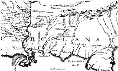
COXE’S CAROLANA.
[Part of the Map of Carolana and of the River Meschacebe, in Daniel Coxe’s Description of the English Province of Carolana, London, 1742—Ed.]
Thomas Hutchins has also published two books,—An Historical Narrative and Topographical Description of Louisiana, etc. (Philadelphia, 1784), and A Topographical Description, etc. (London, 1778).
Captain Philip Pittman prepared a report on The Present State of the European Settlements on the Mississippi. It was published in London, in 1770. It is embellished with charts of the river and plans of several of the forts and villages.[109]
Also Sketches of History, Life and Manners in the West, by James Hall (Philadelphia, 1835), who visited the fort in 1829.
The Early History of Illinois, by Sidney Breese, contains an interesting description of French life in Illinois.[110] See also a chapter on the same subject in Davidson and Stuvé’s Complete History of Illinois (Springfield, 1874). The History of the Discovery and Settlement of the Mississippi Valley, by John W. Monette (New York, 1846), also has an elaborate sketch of the settlement of Louisiana and Illinois.[111]
Mississippi as a Province, Territory, and State, by J. F. H. Claiborne (1880), devotes considerable space to the Province.
Extracts from a memoir by M. Marigny de Mandeville may be found in several of the histories of Louisiana of colonial times. In a note in Bossu[112] it is stated that such a work was published in Paris in 1765.
The story of Saint-Denys’ experiences in Mexico is told in H. H. Bancroft’s North Mexican States, p. 612 et seq., in which the sources of information are mainly Mexican and Spanish. The hero of Penicaut’s romances, viewed from this standpoint, becomes a mere smuggler.
Under the title Historical Collections of Louisiana, etc., Mr. B. F. French, in the years 1846-1875, inclusive, published seven volumes containing reprints and translations of original documents and rare books. Mr. French was a pioneer in a class of work the value of which has come to be fully appreciated. His Collections close a gap on the shelves of many libraries which it would be difficult otherwise to fill. The work was necessarily an education to him, and in some instances new material which came to his hands revealed errors in previous annotations.[113] The value of the work would have been increased if abridgments and omissions had been noted.[114] The translation of the Journal historique, etc., given in the collection was made from the manuscript copy in the library of the American Philosophical Society at Philadelphia.[115] The Penicaut relation differs materially from the copy published by Margry.[116] The labors of Mr. French, as a whole, have been of great service to students of American history.[117]
The fourth and fifth volumes[118] of Pierre Margry’s Découvertes et établissements des Français dans l’ouest et dans le sud de l’Amérique septentrionale contain the material upon which so much of this chapter as relates to Iberville’s expeditions is founded. We have here Iberville’s correspondence with the minister, his memorials, the instructions given to him, and his reports.[119] There are also some of Bienville’s despatches, and the correspondence with the engineer about New Orleans and about the bar at the mouth of the river. The publication of these volumes has enabled us to correct several minor errors which have been transmitted from the earlier chroniclers. Interesting as the volumes are, and close as their scrutiny brings us to the daily life of the celebrated explorer, it is not easy to understand why their contents should have been shrouded with such a profound mystery prior to their publication.[120]
The periodicals and tracts of the eighteenth century contain many historical articles and geographical discussions, from which historical gleaners may yet procure new facts.[121] The manuscripts in the Archives at Paris have by no means been exhausted. Harrisse, in his Notes pour servir à l’histoire, etc., de la Nouvelle France (Paris, 1872), gives an account of the vicissitudes which they have undergone. He traces the history of the formation of the Archives of the Marine and of the Colonies and points out the protecting and organizing care, which Colbert during his ministry devoted through intelligent deputies to the arranging of those documentary sources, among which the modern historian finds all that the Revolution of 1789 has left to him.
The copies which from time to time have been procured from France for the State Archives of Louisiana have so generally disappeared, particularly during the Federal occupation, that but a small portion of them still remains in the State Library.[122]

EDITORIAL NOTES.
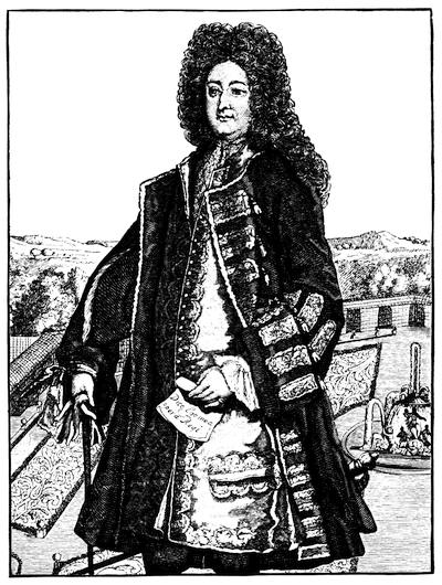
JOHN LAW.
Copied from the head of a full-length portrait in Het Groote Taferel. Rigaud’s portrait of Law is engraved in Alphonse Courtois’ Histoire des banques en France, 2d ed. (Paris, 1881). Cf. also the print in Mouffle d’Angerville’s Vie privée de Louis XV. (Londres, 1781), vol. 1. p. 53.
I. Law and the Mississippi Bubble.—The literature of the Mississippi Scheme is extensive, and includes the relations of Law’s system to general monetary science. The Mississippi excitement instigated the South Sea Scheme in England. Holland, also, was largely affected, and gave, as well as England and France, considerable additions to the contemporary mass of brochures which grew out of these financial revolutions. Law’s own pleas and expositions, as issued in pamphlets, are the central sources of his own views or pretensions, and are included in the Œuvres de J. Law, published at Paris in 1790. These writings are again found in Daire’s Économistes financiers; where will also be met the Essai politique sur le commerce of Melon, Law’s secretary,—a production which Levasseur styles an allegorical history of the system,—and the Réflexions politiques sur les finances et le commerce of Dutot, another of Law’s partisans, who was one of the cashiers of the Company of the Indies, and undertook to correct what he thought misconceptions in Melon; and he was in turn criticised by an opponent of Law, Paris Duverney, in a little book printed at the Hague in 1740, as Examen du livre intitulé, etc.
Law’s proposal for his Mississippi Company is also included in a Dutch collection of similar propositions, printed at the Hague in 1721 as Verzameling van alle de projecten en conditien van de compagnien van assuratie, etc.
There are various Lettres patentes, Édits, Arrests, Ordonnances, etc., issued separately by the French Government, some of which are included in a volume published at Amsterdam in 1720,—Recueil d’arrests et autres pièces pour l’établissement de la compagnie d’occident. Others will be found, by title at least, in the Recueil général des anciennes lois Françoises (Paris, 1830), vol. xxi., with the preambles given at length of some of the more important. Neither of these collections is complete, nor does that of Duhautchamp take their place; but all three, doubtless, contain the chief of such documents.
A few of the contemporary publications may be noted:—
Some Considerations on the Consequences of the French settling Colonies on the Mississippi, from a Gentleman [Beresford] of America to his Friend in London, London, 1720 (Carter-Brown, vol. iii. no. 275).
Impartial Inquiry into the Right of the French King to the Territory west of the Mississippi (London, n. d.).
The Chimera; or, the French way of paying National Debts laid open (London, 1720).
Full and Impartial Account of the Company of the Mississippi ... projected and settled by Mr. Law. To which is added a Description of the Country of the Mississippi and a Relation of the Discovery of it, in Two Letters from a Gentleman to his Friend (London, 1720). In French and English (cf. Carter-Brown, vol. iii. no. 276). This is an incentive to the speculation.
Historische und geographische Beschreibung des an dem grossen Flusse Mississippi in Nord America gelegenen herrlichen Landes Louisiana, etc. (Leipsic, 1720) 8vo. It has a map of Louisiana. There was a second edition the same year in 12mo, with Ausführliche beginning a title otherwise the same (Carter-Brown, vol. iii. nos. 277, 278). It has an appendix, Remarques über den Mississippischen Actien-Handel, which is a translation of a section on Louisiana in Aanmerkigen over den koophandel en het geldt, published at Amsterdam (Muller, Books on America, 1872, nos. 915, 916; 1877, no. 1817).
Le banquerotteur en desespoir; Das ist, der versweifflende Banquerottirer, etc., with a long explanation in German of the lament of a victim, dated 1720, without place, and purporting to be printed from a Dutch copy (cf. Carter-Brown, ii. 258).
Het Groote Tafereel der Dwaasheid, vertoonende de opkomst, voortgang en ondergang der Actie, Bubbel en Windnegotie in Vrankryk, Engeland en de Nederlanden, gepleegt in dem Jaare DDCCXX. (1720). This is a folio volume of satire, interesting for its plates, most of which are burlesques; but among them are a full-length portrait of Law, another of Mrs. Law in her finery, and a map of Louisiana. There is a copy in Harvard College Library. Cf. Carter-Brown, vol. iii. no. 270; Muller, Books on America (1872), no. 1503.
There is in the Boston Public Library a contemporary manuscript entitled, Mémoire d’après les voyages par Charles Le Gac, directeur de la Comp. des Indes à la Louisiane, sur la Louisiane, sa géographie, la situation de la colonie Française, du 26 aoust 1718 au 6 mars 1721, et des moyens de l’améliorer. Manuscrit redigé en 1722. Le Gac was the agent of Law’s Company during these years.
The earliest personal sketch which we have noted is a Leven en character van J. Law (Amsterdam, 1722).
A Sketch of the Life and Projects of John Law was published in Edinburgh in 1791, afterward included in J. P. Wood’s Ancient and Modern State of the Parish of Cramond (Edinburgh, 1794), and the foundation of the later Life of John Law of Lauriston, published by Wood at Edinburgh in 1824. This may be supplemented in some points by Chambers’s Biographical Dictionary of Eminent Scotsmen.

Professor Smyth found, when he assigned one of his Lectures on Modern History (no. 27) to Law and his exploits, that he got at that time the best exposition for his system in English from Steuart’s Political Economy. The latest summarized statement in English will be found in Lalor’s Cyclopædia of Political Science, vol. ii. (1883), and a good one in Mackay’s Popular Delusions. The general historians of England, more particularly Stanhope, do not tell the story of the great imitatory pageant of the South Sea Scheme without more or less reference to Law. Those of the United States necessarily recount the train of events in Paris, of which Louisiana was the background. A few English monographs, like J. Murray’s French Financiers under Louis XV., and an anonymous book, Law, the Financier, his Scheme and Times (London, 1856), cover specially the great projector’s career; while the best key to his fate at the hands of magazinists will be found in Poole’s Index to Periodical Literature (pp. 728, 854), where a popular exposition by Irving is noted, which having appeared in the Knickerbocker Magazine (vol. xv. pp. 305, 450), has since been included in the volume of his works called Wolfert’s Roost, and other Papers.
In France the treatment of the great delusion has been frequent. The chief source of later writers has been perhaps Duhautchamp’s Histoire du systéme des finances (à la Haye, 1739), which, with his account of the Visa, makes a full exposition of the rise and fall of the excitement by one who was in the midst of it. His fifth and sixth volumes contain the most complete body of the legislation attending the movement. Forbonnais’ Recherches et considérations sur les finances de France à l’année 1721 (Basle, 1758) is a work of great research, and free from prejudice. The Encyclopédie méthodique (1783) in its essays on commerce and banking contributes valuable aid, and there is a critical review in Ch. Ganilh’s Essai sur le revenu public (Paris, 1806). To these may be added Bailly’s Histoire financière de la France (Paris, 1830); Eugène Daire’s “Notice historique sur Jean Law, ses écrits et les opérations du système,” in his Économistes financiers du dix-huitième siècle (1843); Théodore Vial’s Law, et le système du papier-monnaie de 1716 (1849); A. Cochut’s Law, son système et son époque (1853); J. B. H. R. Capefigue’s Histoire des grandes opérations financières (Paris, 1855), vol. i. p. 116; J. P. Clément’s Portraits historiques (1856); and le Baron Nervo’s Les finances Françaises (Paris, 1863). L. A. Thiers’ encyclopedic article on Law was translated and annotated by Frank S. Fiske as Memoir of the Mississippi Bubble, and published in New York in 1859. This is perhaps the best single book for an English reader, who may find in an appendix to it the account of the Darien Expedition from the Encyclopædia Britannica, and one of the South Sea Scheme from Mackay’s Popular Delusions. Thiers’ French text was at the same time revised and published separately in Paris in 1858. Among other French monographs P. E. Levasseur’s Recherches historiques sur le système de Law (Paris, 1854, and again, 1857) is perhaps the most complete treatment which the subject has yet received. We may further add Jules Michelet’s “Paris et la France sous Law” in the Revue de deux mondes, 1863, vol. xliv.; and the general histories of France, notably Martin’s and Guizot’s, of which there are English versions; the special works on the reign of Louis XV., like De Tocqueville’s; P. E. Lémontey’s Histoire de la Régence (Paris, 1832); J. F. Marmontel’s Régence du duc de Orléans (1805), vol. i. p. 168; and the conglomerate monograph of La Croix, Dix-huitième siècle (Paris, 1875), chap. viii. Law finds his most vigorous defender in Louis Blanc, in a chapter of the introduction to his Révolution Française.
The Germans have not made their treatment of the subject very prominent, but reference may be made to J. Heymann’s Law und sein System (1853).
The strong dramatic contrasts of Law’s career have served the English novelist Ainsworth in a story which is known by the projector’s name; but the reader will better get all the contrasts and extraordinary vicissitudes of the social concomitants of the time in the Mémoires of St. Simon, Richelieu, Pollnitz, Barbier, Dangeau, Duclos, and others.
The familiarity of Mr. Davis with the subject has been of great assistance to the Editor in making this survey.
II. The Story of Moncacht-Apé.—The writer of this chapter has, in the Proceedings of the American Antiquarian Society, April 25, 1883, printed a paper on the story of Moncacht-Apé,—an Indian of the Yazoo tribe, who claimed to have made a journey from the Mississippi to the Pacific about the year 1700, which paper has also been printed separately as The Journey of Moncacht-Apé. The story, which first appeared in Le Page du Pratz’ contributions to the Journal œconomique, and first took permanent form in Dumont’s Mémoires in 1753, was made in part to depend for its ethnological interest on the Yazoo marrying a captive Indian, who tells him a story of bearded white men being seen on the Pacific coast. That the Yazoo himself encountered on the Pacific coast a bearded people who came there annually in ships for dye-wood, is derived from the fuller narrative which Le Page du Pratz himself gives in his Histoire de la Louisiane published five years later, in 1758.
Mr. Davis does not find any consideration of the verity of the story till Samuel Engel discussed it in his Mémoires et observations géographiques, published at Lausanne in 1765, which had a chart showing what he conceived to be the route of the Indian, as Le Page du Pratz had traced it, in tracking him from the Missouri to the streams which feed the Columbia River. The story was later examined by Mr. Andrew Stewart in The Transactions of the Literary and Historical Society of Quebec, i. 198 (1829), who accepted the tale as truthful; and Greenhow, in his History of Oregon (Boston, 1844, p. 145), rejects as improbable only the ending as Dumont gives it. In 1881, when M. de Quatrefage rehearsed the story in the Revue d’anthropologie, vol. iv., he argued that the bearded men must have been Japanese. It was this paper of the distinguished French anthropologist which incited Mr. Davis to the study of the narrative; and it is by his discrimination that we are reminded how the story grew to have the suspicious termination, after Le Page had communicated it to Dumont; so that in Mr. Davis’s judgment one is “forced to the unwilling conclusion that the original story of the savage suffered changes at Le Page’s hands.” The story has since been examined by H. H. Bancroft in his Northwest Coast, i. 599 et seq., who sees no reason to doubt the truth of the narrative.
There is an account of the early maps of the country west of Lake Superior and of the headwaters of the Mississippi in Winchell’s Geological Survey of Minnesota, Final Report, vol. i., with a fac-simile of one of 1737. Between 1730 and 1740 Verendrye and his companions explored the country west and northwest of Lake Superior, and reached the Rocky Mountains. Mills, Boundaries of Ontario, p. 75, says he failed to find in the Moniteur, September and November, 1857, the account of Verendrye’s discoveries by Margry, to which Garneau refers.
CARTOGRAPHY
OF
LOUISIANA AND THE MISSISSIPPI BASIN UNDER THE FRENCH DOMINATION.
BY THE EDITOR.
THE original spelling of the name Mississippi, the nearest approach to the Algonquin word, is Mêché Sébè,[123] a form still commonly used by the Louisiana creoles. Tonty suggested Miche Sepe; Father Laval, Michisepe, which by Father Labatt was softened into Misisipi. Marquette added the first s in Missisipi, and some other explorer a second in Mississipi, as it is spelled in France to-day. No one knows who added a second p in Mississippi, for it was generally spelled with one p when the United States bought Louisiana.[124]
In Vol. IV. of the present History the earliest maps of the Mississippi Basin are enumerated, and fac-similes or sketches of the following may be seen in that volume:—
1672-73 (p. 221). An anonymous map of the course of the Mississippi, which is also to be found in Breese’s Early Hist. of Illinois. Other early maps, without date, are noted in Vol. IV. at pp. 206, 215.
1673-74 (pp. 208, 212, 214, 218). Joliet’s maps; and (p. 220) Marquette’s map, which has since been reproduced in Andreas’s Chicago, i. p. 47.
1682-84-88 (pp. 227, 228, 230, 231). Franquelin’s maps,—the last of which has since been reproduced in Winchell’s Geological Survey of Minnesota, Final Report, i. pl. 2.
1683-97 (pp. 249, 251, 252, 253). Hennepin’s maps, also to be found in Winchell and Breese.
1685 (p. 237). Minet’s map; and without date (p. 235) the map of Raudin. The map which accompanied Joutel’s Journal in 1713 also gave the topography of the time of Lasalle. (See p. 240.)
1688 (p. 232). The map of Coronelli and Tillemon; and (p. 233) that of Raffeix.
1702 (p. 394). The map in Campanius.
1703-1709 (pp. 258, 259, 260, 261). Maps in Lahontan.
It is in continuation of this series, which includes others not here mentioned, that the following enumeration is offered of the cartographical results which controlled and developed the maps of the eighteenth century.
The plates of the maps of Nicolas Sanson, who had died in 1667,[125] were towards the end of that century in the hands of Hubert Jaillot, who was later a royal geographer of France.[126] He published in Paris, in 1692, what passes for Sanson’s Amérique Septentrionale, with adaptations to contemporary knowledge of American geography. It naturally augments the claims of the French to the disputed areas of the continent. It was reissued at Amsterdam not long after as “Dressée sur les observations de Mrs de l’Academie Royale des Sciences.” The plate was long in use in Amsterdam, and I have noticed reissues as late as 1755 by Ottens.
The English claims to the westward at this time will be seen in “The Plantations of England in America,” contained in Edward Wells’ New Sett of Maps, London, 1698-99.[127]
The most distinguished French cartographers of the early part of the eighteenth century were the father and son, Claude and Guillaume Delisle. The father, Claude, died in 1720 at 76; the son, six years later, in 1726, at 51.[128] Their maps of Amérique Septentrionale were published at Paris of various dates in the first quarter of the century, and were reissued at Amsterdam.[129] Their Carte de la Louisiane et du Cours du Mississipi appeared first at Paris in 1703, and amended copies appeared at various later dates.[130] Thomassy[131] refers to an original draft by Guillaume Delisle, Carte de la rivière du Mississipi, dressée sur les mémoires de M. Le Sueur, 1702, which is preserved in the Archives Scientifiques de la Marine, at Paris. Thomassy (p. 211) also refers to an edition of Delisle’s Carte de la Louisiane, published in June, 1718, by the Compagnie d’Occident. Gov. Burnet wrote of this map to the Lords of Trade[132], that Delisle had taken from the borders of New York and Pennsylvania fifty leagues of territory, which he had allowed to the English in his map of 1703.
There is an Amsterdam edition (1722) of Delisle’s Carte du Mexique et de La Floride, des Terres Angloises et des Isles Antilles, du Cours et des Environs de la Rivière de Mississipi, measuring 24 × 19 inches, which includes nearly the whole of North America.
Nicholas de Fer was at this time the royal geographer of Belgium, 1701-1716.[133] We note several of his maps:—
Les Costes aux Environs de la Rivière de Misissipi, par N. de Fer, 1701. This extends from Cape Roman (Carolina) to the Texas coast, and shows the Mississippi up to the “Nihata” village. There is a copy in the Sparks MSS., vol. xxviii.
Le Vieux Mexique avec les Costes de la Floride, par N. de Fer, 1705. This extends south to the Isthmus of Panama. There is a copy in the Sparks MSS., vol. xxviii.
Le Canada ou Nouvelle France, Paris, 1705. There is a copy in the Sparks MSS., vol. xxviii. It shows North America from Labrador to Florida, and includes the Mississippi valley. The region west of the Alleghanies is given to France, as well as the water-shed of the lower St. Lawrence.
De Fer also published, in 1717, Le Golfe de Mexique et les provinces et isles qui l’environne [sic].
In 1718 his Le Cours du Mississipi ou de Saint Louis was published by the Compagnie d’Occident.
Making a part of Herman Moll’s New and exact Map of the Dominions of the King of Great Britain on the Continent of North America, measuring 24 × 40 inches, issued in 1715, was a lesser draft called Louisiana, with the indian settlements and number of fighting men according to the account of Capt. T. Nearn.[134]
When Moll, in 1720, published his New Map of the North Parts of America claimed by France under the name of Louisiana, Mississippi, Canada, and New France, with the adjoining territories of England and Spain (measuring 24 × 40 inches), he said that a great part of it was taken from “the original draughts of Mr. Blackmore, the ingenious Mr. Berisford, now residing in Carolina, Capt. Nairn, and others never before published.” He adds that the southwest part followed a map by Delisle, published in Paris in June, 1718.[135]
In 1719 the Sieur Diron made observations for a map preserved in the Bibliothèque Nationale at Paris, Fleuve Saint Louis, ci-devant Mississipi, showing the course of the river from New Orleans to Cahokia, which was not drawn, however, till 1732.[136] About the same time (1719-20) the surveys of M. De Sérigny were used in another map, preserved in the Archives Scientifiques de la Marine, Carte des Côtes de la Louisiane depuis les bouches du Mississipi jusqu’à la baie de Saint-Joseph. Part of the gulf shore of this map is reproduced in Thomassy (plate ii.).
The year 1719 is also assigned to John Senex’s Map of Louisiana and the river Mississipi, most humbly inscribed to Law of Lawreston, measuring 22 X 19 inches.[137]
Gerard van Keulen published at Amsterdam, in 1720, a large map, in two sheets, Carte de la Nouvelle France ou se voit le cours des grandes Rivières Mississipi et S. Laurens, with annotations on the French fortified posts.
At Paris, in November, 1720, De Beauvilliers took the observations of La Harpe and drafted a Carte nouvelle de la parte de l’ouest de la province de la Louisiane.[138]
The map of Coxe’s Carolana, 1722, is given in fac-simile on an earlier page (ante, p. 70).
The Memoirs of John Ker of Kersland (London, 1726) contain a “new map of Louisiana, and the river Mississipi.”[139]
The map in La Potherie’s Histoire de l’Amérique Septentrionale (Paris, 1722, vol. ii.), called “Carte généralle de la Nouvelle France,” retains the misplacement of the mouths of the Mississippi, as La Salle had conceived them to be on the western shore of the gulf, giving the name “Baye de Spiritu Sancto” to an inlet more nearly in the true position of its mouths.
Thomassy[140] points out that William Darby, in his Geographical Description of Louisiana (2d ed. 1817), in reproducing Jean Baptiste Homann’s map of Louisiana, published at Nuremberg as the earliest of the country which he could find, was unfortunate in accepting for such purpose a mere perversion of the earlier and original French maps. Homann, moreover, was one of those geographers of easy conscience, who never or seldom date a map, and the German cartographer seems in this instance to have done little more than reëngrave the map which accompanied the Paris publication of Joutel’s Journal historique, in 1713. Homann’s map, called Amplisimæ regionis Mississipi seu Provinciæ Ludovicianæ a Hennepin detectæ anno 1687, was published not far from 1730, and extending so as to include Acadia, Lake Superior, and Texas, defines the respective bounds of the English, French, and Spanish possessions.[141]
When Moll published his New Survey of the Globe, in 1729, he included in it (no. 27) a map of New France and Louisiana, showing how they hemmed in the English colonies.
Henry Popple’s Map of the British Empire in America, with the French and Spanish Settlements adjacent thereto, was issued in London in twenty sheets, under the patronage of the Lords of Trade, in 1732; and reissued in 1733 and 1740.[142] A reproduction was published at Amsterdam, about 1737, by Covens and Mortier. Popple’s map was for the Mississippi valley, in large part based on Delisle’s map of 1718.
Jean Baptiste D’Anville was in the early prime of his activity when the Delisles passed off the stage, having been born in 1697, and a long life was before him, for he did not die till 1782, having gained the name of being the first to raise geography to the dignity of an exact science.[143] He had an instinct for physical geography, and gained credit for his critical discrimination between conflicting reports, which final surveys verified. His principal Carte de la Louisiane was issued as “Dressée en 1732; publiée en 1752.”[144] His map of Amérique Septentrionale usually bears date 1746-48; and a new draft of it, with improvements, was published at Nuremberg in 1756.
A map made by Dumont de Montigny about 1740, Carte de la province de la Louisiane, autrefois le Mississipi, preserved in the Dépôt de la Marine at Paris, is said by Thomassy (p. 217) to be more valuable for its historical legends than for its geography.
In 1744 the maps of Nicolas Bellin were attached to the Nouvelle France of Charlevoix, and they include, beside the map of North America, a Carte de la Louisiane, Cours du Mississipi, et pais voisins.[145] Bellin’s Carte des embouchures du fleuve Saint-Louis (1744) is based on a draft by Buache (1732), following an original manuscript (1731) preserved in the Archives Scientifiques de la Marine, in Paris.