Chapter I · (continued 3)
Reading edition
Bellin also dates in 1750 a Carte de la Louisiane et des pays voisins, and in an atlas of his, Amérique Septentrionale, Atlas maritime, published in 1764 by order of the Duc de Choiseul, Bellin includes various other and even earlier maps of Louisiana.[146]
Thomassy[147] also refers to a MS. map in the Bibliothèque Nationale, Carte de la Coste et Province de la Louisiane, dated at New Orleans, October 5, 1746, which is not, however, of much value.
There is a “Carte de la Louisiane” in Dumont de Montigny’s Mémoires historiques de la Louisiane, vol. i. (1753), a fac-simile of which is given herewith. It perhaps follows the one referred to above.
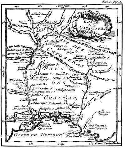
LOUISIANA. (Dumont.)
There is on a later page a fac-simile of the map, showing the carrying-place between the St. Lawrence and Mississippi valleys, which appeared in the London (1747 and 1755) editions of Cadwallader Colden’s History of the Five Indian Nations of Canada.
The controversy over the bounds of the French and English possessions, which was so unproductive of results in 1755, caused a large number of maps to be issued, representing the interests of either side. The French claimed in the main the water-shed of the St. Lawrence and the lakes, and that of the Mississippi and its tributaries. The English conceded to them a southern limit following the St. Lawrence and the Ottawa, thence across Huron and Michigan, to the Illinois, descending that river to the Mississippi; and consequently denied them the southern water-shed of the St. Lawrence and most of the eastern water-shed of the Mississippi.
On the French side the following maps may be named:—
The great D’Anville map, Canada, Louisiane, et les terres anglaises, which was followed in the next year (1756) by D’Anville’s Mémoire on the same map; Robert de Vaugondy’s Partie de l’Amérique Septentrionale qui comprend le Cours de l’Ohio, la Nlle Angleterre, la Nlle York, New Jersey, Pensylvanie, Maryland, Virginie, Caroline; Carte Nouvelle de l’Amérique Angloise contenant le Canada, la Nouvelle Ecosse ou Acadie, les treize Provinces unies, avec la Floride, par Matthieu Albert Lotter, published at Augsburg, without date; Carte des possessions Angloises et Françoises du Continent de l’Amérique Septentrionale, published by Ottens at Amsterdam, 1755; Carte de l’Amérique Septentrionale, par M. Bellin, 1755; in the same year the Partie Orientale, et partie Occidentale de la Nouvelle France ou du Canada, likewise by Bellin;[148] and the Carte de la Louisiane par le Sieur Bellin, 1750, sur de nouvelles Observations on a corrigé les lacs, et leurs environs, 1755; Canada et Louisiane, par le Sieur le Rouge, ingénieur géographe du Roi, Paris, 1755, with a marginal map of the Mississippi River.
In the English interests there were several leading maps: A new and accurate map of North America (wherein the errors of all preceding British, French, and Dutch maps respecting the rights of Great Britain, France, and Spain, and the limits of each of His Majesty’s Provinces are corrected), by Huske. This was engraved by Thomas Kitchin, and published by Dodsley at London, 1755. It gives the names of the French trading posts and stations. John Huske also printed The Present State of North America, Part I., London, 1755, which appeared in a 2d edition the same year with emendations, giving Huske’s map, colored, leaving the encroachments of the French uncolored. It was also reprinted in Boston, in the same year.[149]
Another is A map of the British Colonies in North America, with the roads, distances, limits, and extent of the settlements. This is John Mitchell’s map, in six sheets, engraved by Kitchin, published in London by Jefferys and Faden, 1755. John Pownall, under date of February 13, 1755, certifies to the approval of the Lords of Trade.[150] It was reëngraved, with improvements, a year or two later, at Amsterdam, by Covens and Mortier, under the title Map of the British and French Dominions in North America, on four sheets, with marginal plans of Quebec, Halifax, Louisbourg, etc.[151]
Lewis Evans issued his General Map of the Middle British Colonies in America in 1755,[152] and it was forwarded to Braddock after he had taken the field, for his assistance in entering upon the disputed territory of the Ohio Valley,—indeed, its publication was hastened by that event, the preface of the accompanying pamphlet being dated Aug. 9, 1755.
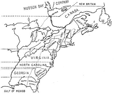
HUSKE’S MAP, 1755.
This is sketched from the colored folding map in John Huske’s Present State of North America, &c., second edition, London, 1755. The easterly of the two pricked (dots) lines marks the limits within which the French claimed to confine the English seaboard colonies. Canada, or the region north of the St. Lawrence, east of the Ottawa, and south of the Hudson Bay Company and New Britain, together with the islands in the Gulf of St. Lawrence, and the northerly coasts of Newfoundland (to dry fish upon), constitute all that the British allowed to France. The stars represent the forts which they had established in the disputed territory; while the circle and dot show the frontier fortified posts of the English, as Huske gives them. The English claimed for the province of New York all the territory north of the Virginia line, west of Pennsylvania, and west of the Ottawa, and south of the Hudson Bay Company’s line. Virginia, the two Carolinas, and Georgia extended indefinitely westward. The northern line of Virginia was established by the charter of 1606; the southern bounds mark where the Carolina charter of 1665 begins, and the bounds of Spanish Florida denote that charter’s southern limit, the territory being divided by the subsequent grant of Georgia. The space between the pricked line, already mentioned, and the other pricked line, which follows the Mississippi River to the north, is the land which is called in a legend on the map the hereditary and conquered country of the Iroquois, which had been ceded by them to the British crown by treaties and a deed of sale (1701), and confirmed by the treaties of Utrecht and Aix-la-Chapelle. Cf. Description of the English and French territories in North America, being an explanation of a new map, shewing the encroachments of the French, with their Forts and Usurpations on the English settlements; and the fortifications of the latter. Dublin, 1755 (Carter-Brown, iii. 1056).
Jefferys pirated Evans’ map, and published it in 1758, “with improvements by I. Gibson,” and in this form it is included in Jefferys’ General Topography of North America and the West Indies, London, 1768. Pownall, who was accused of procuring the dedication of the original issue by “a valuable consideration” (Mass. Hist. Coll., vii. 136), called Jefferys’ reproduction badly done, and reissued Evans’ work in 1776, under the following title: A map of the Middle British Colonies in North America, first published by Mr. Lewis Evans of Philadelphia in 1755, and since corrected and improved, as also extended ... from actual surveys now lying at the Board of Trade, by T. Pownall, M. P., Printed and published for J. Almon, London, March 25, 1776. In this form the original plate was used as “Engraved by James Turner in Philadelphia,” embodying some corrections, while the extensions consisted of an additional engraved sheet, carrying the New England coasts from Buzzard’s to Passamaquoddy Bay.
A French copy, with amendments, was published in 1777.[153]
The map was also reëngraved in London, “carefully copied from the original published at Philadelphia by Mr. Lewis Evans.” It omits the dedication to Pownall, and is inscribed “Printed for Carrington Bowles, London; published, Jan. 1, 1771.” It has various legends not on Evans’ map, and omits some details, notwithstanding its professed correspondence. Evans had used the Greek character [Greek: ch] to express the gh of the Indian names, which is rendered in the Bowles map ch.
Another plate of Evans’ map was engraved in London, and published there by Sayer and Bennett, Oct. 15, 1776, to show the “seat of war.” It covers the same field as the map of 1755, and uses the same main title; but it is claimed to have been “improved from several surveys made after the late war, and corrected from Governor Pownall’s late map, 1776.” The side map is extended so as to include Lake Superior, and is called “A sketch of the upper parts of Canada.” Smith (1756) says: “Evans’ map and first pamphlet were published in the summer, 1755, and that part in favor of the French claim to Frontenac was attacked by two papers in the N. Y. Mercury, Jan. 5, 1756. This occasioned the publication of a second pamphlet the next spring, in which he endeavors to support his map.”[154]
Evans’ pamphlet is called Geographical, historical, political, philosophical, and mechanical essays. The first, containing an analysis of a general map of the middle British colonies in America; and of the country of the confederate Indians [etc.]. Philadelphia, 1755. iv. 32 pp. 4º. A second edition, with the title unchanged, appeared the same year, while “Part ii.” was published in the following year.[155]
By Gen. Shirley’s order N. Alexander made a map of the frontier posts from New York to Virginia, which is noted in the Catal. of the King’s maps (British Museum), ii. 24. This may be a duplicate of a MS. map said by Parkman (i. p. 422) to be in the Public Record office, America and West Indies, lxxxii., showing the position of thirty-five posts from the James River to Esopus on the Hudson.
Le Page du Pratz gave a “Carte de la Louisiane, par l’Auteur, 1757,” in his Histoire de la Louisiane (vol. i. p. 138), a part of which map is reproduced herewith. See also ante, p. 66.
In the Gentleman’s Magazine, 1757, p. 74, is “A map of that part of America which was the principal seat of war in 1756,” defining the Ottawa River as the bounds under the treaty of Utrecht.
Janvier’s L’Amérique, in 1760, carried the bounds of Louisiana to the Pacific.
Pouchot, in a letter dated at Montreal, April 14, 1758, describes a map, which he gives in his Mémoires, vol. iii., where it is called “Carte des frontières Françoises et Angloises dans le Canada depuis Montreal jusques au Fort Du Quesne.” It is reproduced in Dr. Hough’s translation of Pouchot, in the Pennsylvania Archives, second series, vi. p. 409, and in N. Y. Col. Hist., vol. x.
In 1760 Thomas Jefferys included a map of Canada and the north part of Louisiana in The Natural and Civil History of the French Dominion in North and South America, purporting to be “from the French of Mr. D’Anville, improved with the back settlements of Virginia and course of the Ohio, illustrated with geographical and historical remarks,” with marginal tables of “French Incroachments,” and “English titles to their settlements on the Continent.” This map ran the northern bounds of the English possessions along the St. Lawrence, up the Ottawa, across the lakes, and down the Illinois and the Mississippi. The northern bounds of Canada follow the height of land defining the southern limits of the Hudson Bay Company.
After the peace of 1763, Jefferys inserted copies of this map (dated 1762) in the Topography of North America and the West Indies (London, 1768), adding to it, “the boundaries of the Provinces since the Conquest laid down as settled by the King in Council.” The map of 1762 is reproduced in Mills’ Boundaries of Ontario.[156]
Jefferys also gave in the same book (1768) a map of the mouths of the Mississippi and the neighboring coasts, which, he says, was taken from several Spanish and French drafts, compared with D’Anville’s of 1752 and with P. Laval’s Voyage à Louisiane.
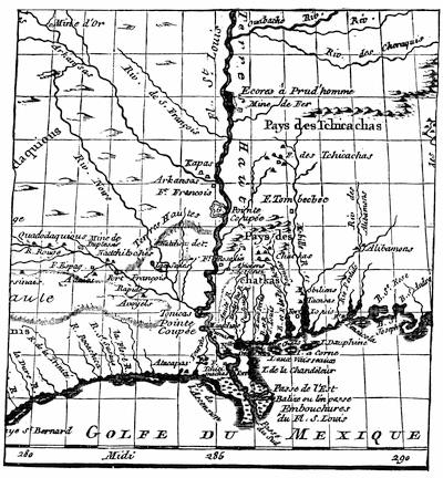
LOUISIANA. (Le Page du Pratz.)