Chapter II · (continued 3)
Reading edition
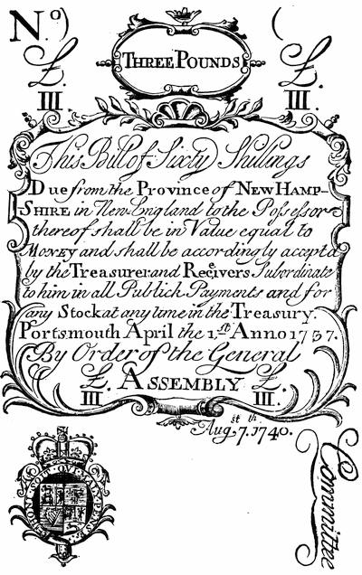
NEW HAMPSHIRE THREE-POUNDS BILL, 1740.
From an original bill in the Harvard College copy of Phillips’ Hist. Sketches. There is a fac-simile of a N. H. bill of forty shillings in Gay’s Pop. Hist. U. S., iii. p. 133; and one of a bill of 1742-43 in Cassell’s Hist. United States, i. p. 486.
A fortunate plan for withdrawing the debased paper currency of Massachusetts Bay was finally matured.[416] Though the taking of Louisbourg had severely taxed the colony with a financial burden, the loss of it by treaty now made the way clear to throw off the same burden. William Bollan, the son-in-law of Shirley, had gone over after the Peace of Aix-la-Chapelle to represent how the sacrifices of New England deserved more recognition than was seemingly paid them in the surrender of her conquest. This and other reasons prevailed, and the government agreed to reimburse the province for the cost of the siege. This was reckoned on the new basis of paper money. Shirley in 1743 had been allowed to give his assent to an issue called “new tenor,” in which the value to silver was about ten times as great as the enormous flood of issues then in circulation bore, and these last were now known as “old tenor.” On this new basis Louisbourg had cost £261,700, which was held to be equivalent to £183,600 in London, the pound sterling equalling now about 30 shillings of the new tenor, and £11 of the old.[417] This agreement had been reached in 1749,[418] and the specie was shipped to Boston. Two hundred and seventeen chests of Spanish dollars and a hundred casks of copper coin were carted up King Street, in September, the harbinger of new prosperity. It was due most to Thomas Hutchinson’s skilful urgency that the assembly, of which he was now speaker, was induced to devote this specie to the redeeming of the paper bills of the “old tenor,” of which £2,000,000 were in circulation.[419] It was agreed to pay about one pound in specie for ten in paper, and the commissioners closed their labors in 1751, the silver and copper already mentioned paying nine tenths of it, while a tax was laid to pay the remaining tenth. About £1,800,000 in current bills were presented; the rest had been destroyed or hid away and forgotten.[420] Rhode Island had received £6,322 as her share of the whole; but as she was not wise enough to apply it to the bettering of her currency, she suffered the evils of a depreciated paper longer than her neighbors.[421] The same lack of wisdom governed New Hampshire. Connecticut had always been conservative in her monetary practices.
When the Massachusetts Assembly, in 1754, sought to raise money for the expenses of the war then impending, its debate upon an inquisitorial excise bill levying a tax on wines and liquors incited violent opposition. Samuel Cooper launched at the plan a pamphlet called The Crisis.[422] Another brief attack appeared with nothing on the title but The Eclipse, MDCCLIV.[423] Daniel Fowle, however, was accused of printing another satirical account of the Representatives’ proceedings, which was published in 1754 as The Monster of Monsters, and the “Thomas Thumb, Esq.,” of the title is supposed to have shielded Samuel Waterhouse. Fowle was arrested, and the common hangman was directed to burn the pamphlet in King Street.[424] Sabin says that not more than three or four copies of the tract escaped, but the Brinley Catalogue shows two.[425] After his release Fowle printed in Boston the next year (1755) A total Eclipse of Liberty. Being a true and faithful account of the arraignment and examination of Daniel Fowle before the House of Representatives of Massachusetts Bay, Oct. 24, 1754, barely on suspicion of being concerned in printing and publishing a pamphlet, entitled The Monster of Monsters. Written by himself. An Appendix to the late Total Eclipse, etc., appeared in 1756.[426]
In May, 1755, a stamp act went into operation in the province, by which the Representatives had established duties upon vellum, parchment, and paper for two years. It yielded towards defraying the charges of the government about £1,350 for the years in question.[427] Shirley issued a proclamation of its conditions, one of which is in the Boston Public Library, and has been reprinted in its Bulletin, 1884, p. 163.
D. The Bounds of the New England Colonies.—During the provincial period, the external limits and internal divisions of New England were the subject of disagreement. The question as to what constituted the frontier line towards Acadia was constantly in dispute, as is explained elsewhere.[428]
On the western side New York had begun by claiming jurisdiction as far as the Connecticut River. She relinquished this claim in the main, as to her bounds on Connecticut, when that colony pressed her pretensions to a line which ran a score of miles from the Hudson, and when she occupied the territory with her settlers, the final adjustment being reached in 1731.[429]
On the line of Massachusetts the controversy with New York lasted longer. The claim of that province was set forth in a Report made in 1753, which is printed in Smith’s New York (1814 ed., p. 283), and Smith adds that the government of Massachusetts never exhibited the reasons of its claim in answer to this report, but in the spring of 1755 sold lands within the disputed territory.[430] In 1764 the matter was again in controversy. Thomas Hutchinson is thought to have been the author of the Massachusetts argument called The Case of the Provinces of Massachusetts Bay and New York, respecting boundary line between the two provinces (Boston, 1764).[431] Three years later (1767) a meeting of the agents of the two provinces was held at New Haven, by which the disagreement was brought to a conclusion.[432]
For the region north of Massachusetts New York contended more vigorously, and the dispute over the New Hampshire grants in the territory of the present Vermont, which began in 1749, was continued into the Revolutionary period. When, in 1740, the king in council had established the northern line of Massachusetts, the commission of Gov. Benning Wentworth, of New Hampshire, the next year (1741), extended his jurisdiction westward until it met other grants, which he interpreted to mean till it reached a line stretched northerly in prolongation of the westerly boundary of Massachusetts, twenty miles east of the Hudson, and reaching to the southern extremity of Lake Champlain. On the 3d of Jan., 1749, Wentworth made a grant of the town of Bennington, adjacent to such western frontier line. These and other grants of townships which Wentworth made became known as the New Hampshire Grants.[433] The wars prevented much progress in the settlement of these grants, but some of the settlers who were there when the French war closed assembled, it is said, with the Rev. Samuel Peters in 1763 on Mount Pisgah, and broke a bottle of spirits with him, and named the country Verd Mont.
Gov. Colden, of New York, on Dec. 28, 1763, issued a proclamation claiming the land thus held under the grants of Wentworth, basing his rights on the grants in 1664 and 1674 to the Duke of York of “all lands from the west side of the Connecticut River to the east side of the Delaware Bay.” On the 20th July, 1764, the king in council confirmed Colden’s view, and made the Connecticut River the boundary as far as 45° north latitude. When this decision reached Wentworth he had already granted 128 townships. New York began to make counter-grants of the same land, and though the king ordered the authorities of New York to desist, when word reached London of the rising conflict, it was the angry people of the grants rather than the royal will which induced the agents of New York to leave the territory. Gov. John Wentworth continued to make grants till the Revolution, on the New Hampshire side; but though Gov. Moore, of New York, had been restrained (1767), his successors had not the same fear of the royal displeasure. As the war approached, the dispute between New York and the grants grew warmer.[434] In 1773 James Duane, it is thought, was the champion of the New York cause in two pamphlets: A State of the rights of the Colony of New York with respect to its eastern boundary on Connecticut River so far as concerns the late encroachments under the Government of New Hampshire, published by the assembly (New York, 1773); and A Narrative of the proceedings subsequent to the Royal Adjudication concerning the lands to the westward of Connecticut river, lately usurped by New Hampshire (New York, 1773).[435] The next year (1774) Ethan Allen answered the first of these tracts in his Brief narrative of the proceedings of the government of New York. Allen dated at Bennington, Sept. 23, 1774, and his book was published at Hartford.[436]
The war of independence soon gave opportunity for the British authorities on the Canada side to seek to detach the Vermonters from their relations to the revolting colonies.[437] The last of the royal governors of New Hampshire had fled in Sept., 1775, and a congress at Exeter had assumed executive control in Jan., 1776. The next year (1777) a convention framed a constitution, and by a stretch of power, as is told in Ira Allen’s Hist. of Vermont, it was adopted without recurrence to the people’s vote. In March, 1778, the state government was fully organized. The dispute with New York went on. Gov. Clinton issued a proclamation. Ethan Allen answered in an Animadversary Address (Hartford, 1778),[438] and in Dec., 1778, a convention of the people of the grants was held, and their resolution was appended to a document prepared by a committee of the assembly, called A public defence of the right of the New Hampshire grants (so called) on both sides Connecticut river, to associate together, and form themselves into an independent state. Containing remarks on sundry paragraphs of letters from the president of the Council of New Hampshire to his Excellency Governor Chittenden, and the New Hampshire delegates at Congress.[439]
The same year the legislature of New York directed the preparation of a Collection of evidence in vindication of the territorial rights and jurisdiction of the state of New York, against the claims of the commonwealth of Massachusetts and New Hampshire, and the people of the grants who are commonly called Vermonters. It was prepared by James Duane, James Morrin Scott, and Egbert Benson, and is printed in the Fund Publications of the New York Historical Society, 1870 (pp. 277-528). On the other side, Ethan Allen published A vindication of the opposition of the inhabitants of Vermont to the government of New York, and of their right to form an independent state;[440] and in 1780, in connection with Jonas Fay, and by order of the governor and council, he published A concise refutation of the claims of New Hampshire and Massachusetts Bay, to the territory of Vermont; with occasional remarks on the long disputed claim of New York to the same.[441]
In 1782, Ethan Allen again brought out at Hartford his The present state of the controversy between the states of New York and New Hampshire on the one part, and the state of Vermont on the other.[442]
The arguments and proofs were rehearsed in 1784, when the question was to be presented to court, in a brief by James Duane, called State of the evidence and argument in support of the territorial rights of jurisdiction of New York against the government of New Hampshire and the claimants under it, and against the Commonwealth of Massachusetts. An amicable adjustment prevented the publication of this document, and it was first printed in the N. Y. Hist. Soc. Coll. for 1871.[443]
Connecticut claimed certain lands in Northern Pennsylvania, which came within her jurisdiction by the extension of her lines, as expressed in her charter of 1662, westward to the South Sea. New York, being then in the possession of a Christian power, was excepted, but the claim was preserved farther west. In 1753 a company was formed to colonize these Connecticut lands in the Susquehanna valley, and lands were bought of the Indians at Wyoming. The government of Pennsylvania objected, and claimed the lands to be within the bounds of William Penn’s charter. (Cf. Penna. Archives, ii. 120, etc.) The defeat of Braddock checked the dispute, but in 1761 it was renewed. In 1763 the home government required the Connecticut people to desist, on the ground that they had not satisfied the Indian owners. New bargains were then made, and in 1769 settlements again took place. General Gage, as commander-in-chief of the British troops on the continent, refused to interfere. In 1774, William Smith prepared an Examination of the Connecticut claim to lands in Pennsylvania, with an appendix and map (Philadelphia, 1774); and Benjamin Trumbull issued A Plea in vindication of the Connecticut title to the contested lands west of the Province of New York (New Haven, 1774). See entries in the Brinley Catalogue, Nos. 2121, etc. The dispute was later referred to the Continental Congress, which in 1781 decided in favor of Pennsylvania, and Aug. 8, 1782, commissioners were appointed. (Journals of Congress, iv. 59, 64.) Connecticut still claimed west of Pennsylvania, and though she retained for a while the “Western Reserve,” she finally ceded (1796-1800) to the United States all her claims as far as the Mississippi.[444] The claims of Massachusetts, on similar grounds, to land in Michigan and Wisconsin were surrendered to the general government in 1785.
The original patent for the Massachusetts Company made its northern line three miles north of the Merrimac River. New Hampshire claimed that it should be run westerly from a point on the coast three miles north of the mouth of that river. When the Board of Trade, in 1737, selected a commission to adjudicate upon this claim, Massachusetts was not in favor, and New Hampshire got more than she asked, the line being run north of the river three miles, and parallel to it, till it reached the most southerly point of the river’s course, when it was continued due west.[445]
Respecting the boundaries on the side of Maine, there is a journal of Walter Bryent, who in 1741 ran the line between New Hampshire and York County in Maine.[446]
Massachusetts also lost territory in the south. The country of King Philip on the easterly side of Narragansett Bay had been claimed by Plymouth, and Massachusetts, by the union under the province charter, succeeded to the older colony’s claim. An arbitration in 1741 did not give all she claimed to Rhode Island, but it added the eastern towns along the bay.[447] On the frontiers of Connecticut, the towns of Enfield, Suffield, Somers, and Woodstock had been settled by Massachusetts, and by an agreement in 1713 she had included them in her jurisdiction.[448] In 1747, finding the taxes in Massachusetts burdensome from the expenses of the war, these towns applied to be received by Connecticut, and their wish was acceded to, while Massachusetts did not dare risk an appeal to the king in council.[449]
The disputes of Connecticut and Rhode Island respecting the Narragansett country resulted on that side in a loss to Connecticut.[450]
In an interesting paper on the “Origin of the names of towns in Massachusetts,” by William H. Whitmore, in the Proceedings (xii. 393-419) of the Mass. Hist. Society, we can trace the loss of towns to Massachusetts, which she had incorporated, and find some reflection of political changes. Up to 1732 the names of towns were supplied by the petitioners, but after that date the incorporation was made in blank, the governor filling in the name, which may account for the large number of names of English peers and statesmen which were attached to Massachusetts towns during the provincial period. The largest class of the early names seems due to the names of the places in England whence their early settlers came. Prof. F. B. Dexter presented to the American Antiquarian Society, in April, 1885, a paper of similar character respecting the towns of Connecticut.
E. Forts and Frontier Towns of New England.—The large increase during recent years in the study of local history has greatly broadened the field of detail. As scarcely one of the older settlements to the west, north, and east escaped the horrors of the French and Indian wars, the student following out the minor phases must look into the histories of the towns of New England. Convenient finding-lists for these towns are the Check-list of Amer. local history, by F. B. Perkins; Colburn’s Bibliog. of Massachusetts; Bartlett’s Bibliog. of Rhode Island; and A. P. C. Griffin’s “Articles on American local history in Historical Collections, etc.,” now publishing in the Boston Public Library Bulletin.
For the Maine towns particular reference may be made to Cyrus Eaton’s Thomaston, Rockland, and South Thomaston (1863), vol. i.; E. E. Bourne’s Wells and Kennebunk; Cushman’s Ancient Sheepscot and Newcastle; Willis’s Portland (2d ed.); Folsom’s Saco and Biddeford; Eaton’s Warren (2d ed.), which gives a map, marking the sites of the forts about the Georges River; Johnston’s Bristol, Bremen, and Pemaquid, which gives a map of the Damariscotta River and the Pemaquid region, with the settlements of 1751; R. K. Sewall’s Ancient Dominions of Maine; James W. North’s Augusta; G. A. and H. W. Wheeler’s Brunswick, Topsham, and Harpswell, including the ancient territory known as Pejepscot, Boston, 1878 (ch. iv. and xxiii.).
See the present History (Vol. III. p. 365) for notes on the local history of Maine, and (Ibid., p. 364) for references to the general historians,—Sullivan, whose want of perspicuousness Grahame (i. 253) complains of, and Williamson.
At the present Brunswick (Maine), Fort Andros had been built in 1688, and had been demolished in 1694. Capt. John Gyles erected there in August, 1715, a post which was called Fort George. Ruins of it were noticeable at the beginning of this century. There is a sketch of it in Wheeler’s Brunswick, Topsham, and Harpswell, pp. 624, 629.
The fort at St. Georges (Thomaston, Me.) had been built originally in 1719-20, to protect the Waldo patent; it was improved in 1740, and again in 1752 was considerably strengthened. (Williamson, i. 287.)
At Pemaquid, on the spot where Andros had established a post, Phips had built Fort William Henry in 1692, which had been surrendered by Chubb in 1696. It is described in Dummer’s Defence of the New England Charters, p. 31; Mather’s Magnalia, book viii. p. 81. In 1729 Col. David Dunbar erected a stone fort, perhaps on the same foundations, which was called Fort Frederick. There is a plan of the latter post in Johnston’s Bristol, Bremen, and Pemaquid, pp. 216, 264. Cf. Eaton’s Warren, 2d ed.
Further down the Kennebec River and opposite the upper end of Swan Island stood Fort Richmond, which had been built by the Massachusetts people about 1723. Near the present Augusta the Plymouth Company founded Forts Shirley and Western in 1754. There are plans and views of them in J. W. North’s Augusta, pp. 47-49. Cf. Nathan Weston’s Oration at the Centennial Celebration of the Erection of Fort Western, July 4, 1854, Augusta, 1854.
Col. John Winslow planned, in 1754, on a point half a mile below Teconick Falls, the structure known as Fort Halifax, according to the extent shown by the dotted line in the annexed cut.[451] Winslow’s letter to Shirley, with the plan, is in the Mass. Archives, and both are given in North’s Augusta, pp. 59, 60. The fort was completed the next year by William Lithgow, as shown by the black part of the cut, the rear flanker, forming the centre of the original plan, having been built, however, by Winslow. This block-house measured 20 × 20 feet below, and on the overhang 27 × 27 feet. The narrower of the large structures was the barracks, also raised by Winslow, but removed by Lithgow, who built the other portions.
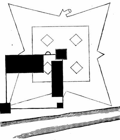
FORT HALIFAX.
The cut follows a reconstruction-draft, made by Mr. T. O. Paine, which is given by North (p. 62). The flanker nearest the river is still standing, and the upright planks on the side, as shown in the annexed cut, mark the efforts which have been made of late to secure the timbers. In the Maine Historical Society’s Collections, vol. viii. p. 198, is a history of the fort by William Goold, as well as the annexed cut of a restoration of the entire fort, drawn by that gentleman from descriptions, from the tracings of the foundations, and from the remaining flanker. The preceding volume (vii.) of the same Collections had contained “materials for a history” of the fort, edited by Joseph Williamson,—mainly documents from the Mass. Archives. A journal of the march of Capt. Eleazer Melvin’s company in Gov. Shirley’s expedition to the Norridgewock country, when Fort Halifax was erected in 1754, kept by John Barber (May 30, 1754-Aug. 17, 1754), is in N. E. Hist. and Gen. Reg., 1873, pp. 281-85. Cf. further in Williamson’s Maine, i. 300; Hutchinson’s Massachusetts, iii. 26. A plan (1754) of the Kennebec River forts, by John Indicott (measuring 38/12 × 15/12), is noted in the Catalogue of the King’s Maps (i. 580), in the British Museum. The forts on the Kennebec, and the chief localities of that river, are described by Col. William Lithgow in 1767, in a deposition printed in the N. E. Hist. and Geneal. Reg., 1870, p. 21. Lithgow was then fifty-two years old, and had known the river from childhood.
In 1752, when there was some prospect of quieting the country, and truck houses were built at Fort Richmond and St. Georges, William Lithgow and Jabez Bradbury were put in charge of them.

A paper by Richard Pike, on the building and occupancy of Fort Pownall, on the Penobscot, is in the N. E. Hist. and Gen. Reg., 1860, p. 4. In Williamson’s Belfast, p. 56, is a conjectural view of the fort, drawn from the descriptions and from a survey of the site in 1828. A Survey of the river and bay of Penobscot, by order of Gov. Pownall, 1759, is among the king’s maps (Catal., ii. 167) in the British Museum. A journal of Pownall’s expedition to begin this fort was printed, with notes, by Joseph Williamson in the Maine Hist. Coll., v. 363. Cf. Williamson’s Maine, i. 337. This fort was completed in July, 1759, at a cost of £5,000, and stood till 1775. Cf. N. E. Hist. and Geneal. Reg., 1859, p. 167, with an extract from the Boston News-Letter, May 31, 1759.
This enumeration covers the principal fortified posts in the disputed territory at the eastward; but numerous other garrison posts, block-houses, and stockades were scattered over the country.[452] A view of one of these, known as Larrabee’s garrison stockade, is given in Bourne’s Wells and Kennebunk, ch. xxi. The view of a block-house built in 1714, near the junction of the Kennebec and Sebasticook rivers, as sketched in 1852, is annexed.
West of Maine the frontier stretched from the Piscataqua to the valley of the Housatonic.
For the New Hampshire part of this line, Belknap’s Hist. of New Hampshire must be supplemented for a general survey by B. H. Hall’s Eastern Vermont. So far as the muster-rolls of frontier service show the activity in New Hampshire, it can be gathered from the second volume of the Report of the Adjutant-General of New Hampshire, 1866, supplemented by others given in the N. H. Revolutionary Rolls, vol. i. (1886). The volumes of the series of Provincial Papers published by that State (vols. ix., xi., xii., xiii.), and called “Town Papers, 1638-1784,” give the local records. The principal town histories detailing the events of the wars are Potter’s Manchester; Bouton’s Concord; Runnel’s Sanbornton; Little’s Warren; C. C. Coffin’s Boscawen; H. H. Saunderson’s Charlestown; B. Chase’s Old Chester; C. J. Fox’s Dunstable; Aldrich’s Walpole; and Morrison’s Windham.
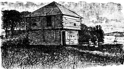
FLANKER, FORT HALIFAX.
In 1704 the assembly of New Hampshire ordered that every householder should provide himself with snow-shoes, for the use of winter scouting parties. (N. H. Prov. Papers, iii. 290.) In 1724 Fort Dummer was built near the modern Brattleboro, in territory then claimed by Massachusetts. (Hist. Mag., x. 109, 141, 178; N. H. Hist. Soc. Coll., i. 143; N. H. Adj.-Gen. Rept., 1866, ii. p. 122.) In 1746, after the alarm over the D’Anville fleet had subsided, Atkinson’s New Hampshire regiment was sent north to meet any invasion from Canada. (N. H. Adj.-Gen. Rept., 1866, ii. 83.) The next year (1747), Walter Bryent advanced with his regiment as far as Lake Winnepesaukee. (N. E. Hist. and Geneal. Reg., July, 1878, p. 297; N. H. Prov. Papers, v. 431, 471; Belknap, ii. 228.)
In 1747 the fort at “no. 4,” or Charlestown, the outpost towards Canada, was attacked. (Saunderson’s Charlestown; Stone’s Sir William Johnson, i. 260.)
In 1752-54 there is record of the hostilities on the New Hampshire borders in the N. H. Prov. Papers, vi. 301, 310-319.
The St. Francis Indians confronted the settlements of the upper Connecticut, and in 1752 Shirley sent Capt. Phineas Stevens to treat with them in the presence of the governor of Canada. (N. Y. Col. Docs., x. 252.) For the massacre at Hinsdale in 1755, and attacks in the Connecticut valley, see N. H. Prov. Papers, vi. 412, and Adj.-Gen. Report, 1866, vol. ii. 153.
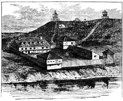
FORT HALIFAX, 1755. (Restoration.)
In 1694-95, the frontier line of Massachusetts was established by law as including the towns of Amesbury, Haverhill, Dunstable, Chelmsford, Groton, Lancaster, Marlborough, and Deerfield. Five years later this list was increased by Brookfield, Mendon, and Woodstock, with a kind of inner line, running through Salisbury, Andover, Billerica, Hatfield, Hadley, Westfield, and Northampton.
For the border troubles of Massachusetts, beside Penhallow and Niles, Neal and Douglass, and the Magnalia, we turn to Hutchinson with confidence in the facilities which he enjoyed; but John Adams says (Works, x. 361), “When Mr. Hutchinson’s History of Massachusetts Bay first appeared, one of the most common criticisms upon it was the slight, cold, and unfeeling manner in which he passed over the Indian wars.”
The most exposed towns fronting the New Hampshire line were Haverhill, Andover, and Dunstable. The History of Haverhill, by G. W. Chase (1861), gives the story of the Indian troubles with much detail.[453] For Andover they may be found in S. L. Bailey’s Historical Sketches of Andover (Boston, 1880); and for Dunstable in Elias Nason’s History of Dunstable (1877). Just below Dunstable lay Groton, and Dr. Samuel A. Green’s Groton during the Indian Wars supplies the want here,—a good supplement to Butler’s Groton. The frontiers for a while were marked nearly along the same meridian by Lancaster, Marlborough, Brookfield, and Oxford. The Early records of Lancaster, 1643-1725, edited by H. S. Nourse (Lancaster, 1884), furnishes us with a full reflection of border experiences during King William’s, Queen Anne’s, and Lovewell’s wars, and it may be supplemented by A. P. Marvin’s History of Lancaster. The sixth chapter of Charles Hudson’s Marlborough (Boston, 1862), and Nathan Fiske’s Historical Discourse on Brookfield and its distresses during the Indian Wars (Boston, 1776), illustrate the period. The struggle of the Huguenots to maintain themselves at Oxford against the Indians is told in Geo. F. Daniels’ Huguenots in the Nipmuck Country (1880), and in C. W. Baird’s Hist. of the Huguenot Emigration to America (1885).
There is in the cabinet of the Mass. Hist. Soc. (Misc. Papers, 41.41) an early plan of the Connecticut and Housatonic valleys, showing the former from the sea as far north as Fort Massachusetts, and the latter up to Fort Dummer, and bearing annotations by Thomas Prince.
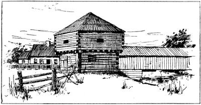
BLOCK HOUSE, BUILT 1714.
In the valley of the Connecticut, Northfield held the northernmost post within the Massachusetts bounds as finally settled. One of the best of our local histories for the details of this barbaric warfare is Temple and Sheldon’s History of Northfield. Deerfield was just south, and it is a centre of interest. The attack which makes it famous came Feb. 29, 1704-5, and the narrative of the Rev. John Williams, who was taken captive to Canada, is the chief contemporary account. Gov. Dudley sent William Dudley to Quebec to effect the release of the prisoners, and among those who returned to Boston (Oct. 25, 1706) was Williams, who soon put to press his Redeemed Captive,[454] which was published in 1707,[455] and has been ever since a leading specimen of a class of books which is known among collectors as “Captivities.”
Further down the Connecticut than Deerfield lies Hadley, which has been more fortunate than most towns in its historian. Sylvester Judd’s History of Hadley, including the early history of Hatfield, South Hadley, Amherst, and Granby, Mass., With family genealogies, by L. M. Boltwood, Northampton, 1863, follows down the successive wars with much detail.[456] A systematic treatment of the whole subject was made by Epaphras Hoyt in his Antiquarian Researches, comprising a history of the Indian Wars in the Country bordering on the Connecticut River, etc., to 1760, published at Greenfield in 1824. There had been published seventy-five years before, A short narrative of mischief done by the French and Indian enemy on the western frontiers of the Province of Massachusetts Bay, Mar. 15, 1743-44, to Aug. 2, 1748, drawn up by the Rev. Mr. Doolittle of Northfield, and found among his manuscripts after his death. Boston, 1750.[457]
By the time of Shirley’s war (1744-48), the frontier line had been pushed westerly to the line of the Housatonic,[458] and at Poontoosuck we find the exposed garrison life repeated, and its gloom and perils narrated in J. E. A. Smith’s History of Pittsfield, 1734-1800 (Boston, 1869). William Williams, long a distinguished resident of this latter town, had been detailed from the Hampshire[459] militia in 1743 to connect the Connecticut and the Hudson with a line of posts, and he constructed forts at the present Heath, Rowe, and Williamstown, known respectively as forts Shirley,[460] Pelham, and Massachusetts. In August, 1746, the latter post, whose garrison was depleted to render assistance during the eastward war, was attacked by the French and Indians, and destroyed.[461]
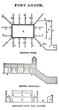
Fort Massachusetts was rebuilt, and its charge, in June, 1747, committed to Major Ephraim Williams.[462] It became the headquarters of the forts and block-houses scattered throughout the region now the county of Berkshire, maintaining garrisons drawn from the neighboring settlers, and at times from the province forces in part. The plans of one of these fortified posts are preserved in the state archives, and from the drawings given in Smith’s Pittsfield (p. 106) the annexed cuts are made.[463]
In 1754 the charge of the western frontier was given to Col. Israel Williams.[464]
These Berkshire garrisons were in some measure assisted by recruits from Connecticut, as that colony could best protect in this way its own frontiers to the northward. Beside the general histories of Connecticut, this part of her history is treated in local monographs like Bronson’s Waterbury, H. R. Stiles’ Ancient Windsor, Cothren’s Ancient Woodbury, Larned’s Windham County, and Orcutt and Beardsley’s Derby.[465]