Chapter VII · (continued 2)
Reading edition
There are papers relating to the first settlement of Halifax in Akins’s Documents, 495; and a paper on the first council meeting at Halifax, by T. B. Akins, in the Nova Scotia Hist. Soc. Coll., vol. ii. See also Murdoch’s Nova Scotia, ii. ch. 11. Various maps of Halifax and the harbor were made during the subsequent years. The Catalogue of the king’s maps (i. 483) in the British Museum shows several manuscript draughts. A small engraved plan was published in the Gentleman’s Magazine, 1750, p. 295. A large map, dedicated to the Earl of Halifax, is called: Carte du havre de Chibucto avec le plan de la ville de Halifax sur la coste de l’Accadie ou Nova Scotia, publiée par Jean Rocque, Charing Cross, 1750.[970]
A smaller Plan des havens von Chebucto und der stadt Halifax was published at Hamburg, 1751. Jefferys issued a large Chart of the Harbor of Halifax, 1759, which was repeated in his General Topography of North America and West Indies, London, 1768. A “Plan de la Baye de Chibouctou nommée par les Anglois Halifax,” bears date 1763. Another is in the Set of plans and forts (No. 7) published in London in 1763. In the Des Barres series of coast charts of a later period (1781) there is a large draft of the harbor, with colored marginal views of the coast.
In 1752-54 there were other conferences with the eastern Indians.
Instructions for treating with the eastern Indians given to the commissioners appointed for that service by the Hon. Spencer Phips ... in 1752, Boston, 1865. Fifty copies printed from the original manuscript, for Samuel G. Drake. (Sabin, xv. 62,579; Brinley, i. no. 443.)
Journal of the proceedings of Jacob Wendell, Samuel Watts, Thomas Hubbard, and Chamber Russel, commissioners to treat with the eastern Indians, held at St. Georges, Oct. 13, 1752, in order to renew and confirm a general peace, Boston, 1752. (Sabin, ix. 36,736; Brinley, i. no. 442.) The original treaty is in the Mass. Archives, xxxiv.
A conference held at St. George’ s on the 20th day of September, 1753, between commissioners appointed by [Gov.] Shirley and the Indians of the Penobscot [and Norridgewock] tribes, Boston, 1753. (Brinley, i. no. 444; Sabin, no. 15,436; Harv. Coll. lib., 5325.42.) Cf. the treaty in Maine Hist. Coll., iv. 168. The original treaties with the Penobscots at St. Georges (Sept. 21) and the Norridgewocks at Richmond (Sept. 29) are in the Mass. Archives, xxxiv.
A journal of the proceedings at two conferences begun to be held at Falmouth, 28th June, 1754, between William Shirley, Governor, etc., and the Chiefs of the Norridegwock Indians, and on the 5th of July with the Chiefs of the Penobscot Indians, Boston, 1754. (Brinley, i. no. 444; Sabin, ix. 36,730; N. H. Prov. Papers, vi. 292.) The original treaties with the Norridgewocks, July 2, and Penobscots, July 6, 1754, are in the Mass. Archives, xxxiv.
THE NECK OF THE ACADIAN PENINSULA.
E. Old French War.—This was begun in April, 1755. There was a declaration of war against the Penobscots, Nov. 3, 1755. (Mass. Archives, xxxii. 690.)
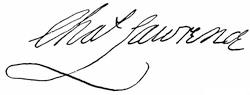
Meanwhile, towards the end of April, 1755, Cornwallis at Halifax had sent Lawrence[971] to the neck of the peninsula[972] of Nova Scotia to fortify himself on English ground, opposite the French post at Beauséjour. Instigated by the French priest, Le Loutre, the Micmacs[973] were so threatening and the French were so alarmingly near that the English, far outnumbered, withdrew; but they returned in the autumn, better equipped, and began the erection of Fort Lawrence. The French attempted an “indirect” resistance through the Indians and some indianized Acadians, and were, in the end, driven off; but not until the houses and barns of neighboring settlers had been burned, with the aim of compelling the Acadians to fly to the French for shelter and sustenance.[974] The French now began a fort on the Beauséjour hill. A petty warfare and reprisals, not unmixed with treachery, became chronic, and were well set off with a background of more portentous rumors.[975] It happened that letters crossed each other, or nearly so, passing between Lawrence (now governor) and Shirley, suggesting an attack on Beauséjour. So the conquest was easily planned. Shirley commissioned Col. John Winslow to raise 2,000 men, and but for delay in the arrival of muskets from England this force would have cast anchor near Fort Lawrence on the first of May instead of the first of June. Monckton, a regular officer, who had been Lawrence’s agent on the Boston mission, held the general command over Winslow, a provincial officer. The fort surrendered before the siege trains got fairly to work. Parkman, who gives a vivid picture of the confusion of the French, refers for his authorities to the Mémoires sur le Canada, 1749-1760; Pichon’s Cape Breton, and the journal of Pichon, as cited by Murdoch in his Hist. of Nova Scotia.[976] The captured fort became Fort Cumberland; Fort Gaspereau, on the other side of the isthmus, surrendered without a blow. Rouse, the Boston privateersman, who had commanded the convoy from Boston, was sent to capture the fort at the mouth of the St. John, and the Indians, whom the French had deserted on Rouse’s approach, joyfully welcomed him.
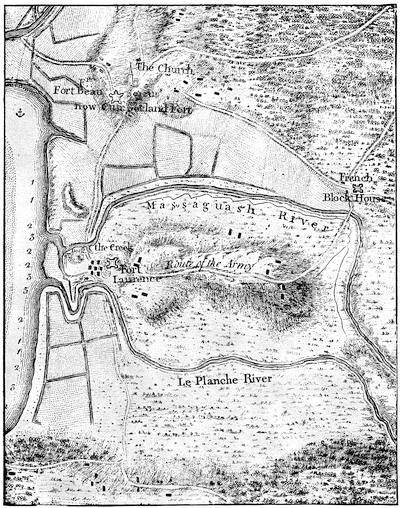
FORT BEAUSÉJOUR AND ADJACENT COUNTRY.
Part of a folding map, “Fort Beauséjour and adjacent country, taken possession of by Colonel Monckton, in June, 1755;” in Mante’s Hist. of the Late War (London, 1772), p. 17. Cf. Des Barres’ Environs of Fort Cumberland, 1781, and various drawn maps in Catal. King’s Library (Brit. Mus.), i. 281.
Three hundred of the young Acadians, the so-called “neutral French,” were found among the defenders of Beauséjour.[977] The council at Halifax had no easy question to solve in determining the next step to be taken.
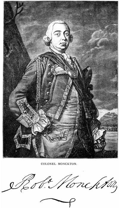
COLONEL MONCKTON.
After a mezzotint preserved in the Amer. Antiq. Soc. library, in which he is called “Major-General, and Colonel of the Seventeenth Foot, and Governor of New York,” as he later was. Cf. other mezzotints noted in J. C. Smith’s Brit. Mezzotint Portraits, ii. 883; iv. 1,525, 1739. There is a portrait in Entick’s Hist. of the Late War, v. 355. See account of Monckton in Akins’s Nova Scotia Docs., 391.
With the documentary evidence now in hand, chiefly the records of the French themselves, we can clearly see the condition which the English rather suspected than knew in detail.[978] They indeed were aware that the neutrals of Chignecto in 1750 had been in effect coerced to crossing the lines at the neck, while the burning of their houses and barns had been accomplished to prevent their return. They further knew that this gave an increased force of desperate and misguided men to be led by priests like Le Loutre, and encouraged by the French commanders, acting under orders of the central government at Quebec. They had good reason to suspect, what was indeed the fact, that the emissaries of the Catholic church and the civil powers in Canada were confident in the use they could in one way and another make of the mass of Acadians, though still nominally subjects of the British king.[979] Their loyalty had always been a qualified one. A reservation of not being obliged to serve in war against the French had been in the past allowed in their oath; but such reservation had not been approved by the Crown, though it had not been practically disallowed. It was a reservation which in the present conjunction of affairs Governor Lawrence thought it inexpedient to allow, and he required an unqualified submission by oath. He had already deprived them of their arms. The oath was persistently refused and the return of their arms demanded. This act was in itself ominous. The British plans had by this time miscarried in New York and Pennsylvania, and under Braddock the forces had suffered signal defeat. The terms of the New England troops in Acadia were fast expiring. With these troops withdrawn, and others of the Acadian garrisons sent to succor the defeated armies farther west, and with the Canadian government prompted to make the most of the disaffection toward the English and of the loyalty to the French flag which existed within the peninsula, there could hardly have been a hope of the retention of the country under the British flag, unless something could be done to neutralize the evil of harboring an enemy.[980] “In fact,” says Parkman, “the Acadians, while calling themselves neutrals, were an enemy encamped in the heart of the province.”[981] Colonel Higginson (Larger History, etc.) presents the antithesis in a milder form, when he says, “They were as inconvenient as neighbors as they are now picturesque in history.” It has been claimed that the cruelty of deportation might have been avoided by exacting hostages of the Acadians. That involves confidence in the ability of an abjectly priest-ridden people to resist the threats of excommunication, should at any time the emissaries of Quebec find it convenient to sacrifice the hostages to secure success to the French arms. Under such a plan the English might too late learn that military execution upon the hostages was a likely accompaniment of a military disaster which it would not avert. The alternative of deportation was much surer, and self-preservation naturally sought the securest means. Simply to drive the Acadians from the country would have added to the reckless hordes allured by the French in 1750, which had fraternized with the Micmacs, and harassed the English settlements. To deport them, and scatter them among the other provinces, so that they could not combine, was a safer and, as they thought, the only certain way to destroy the Acadians as a military danger. It was a terrible conclusion, and must not be confounded with possible errors in carrying out the plan. The council, taking aid from the naval commanders, decided upon it.[982]
The decision and its execution have elicited opinions as diverse as the characters of those who have the tender and the more rigid passions mixed in them in different degrees. The question, however, is simply one of necessity in war to be judged by laws which exclude a gentle forbearance in regard to smaller for the military advantages of larger communities.
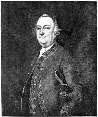
GEN. JOHN WINSLOW.
After an original formerly in the gallery of the Mass. Hist. Soc., but now in Pilgrim Hall, Plymouth. Cf. Mass. Hist. Soc. Proc., xx. 192, and Mem. Hist. Boston, ii. 123. The sword of General Winslow, shown in the cut (Vol. III. p. 274), has also been transferred to Plymouth, as well as the portraits of Governor Edward and Governor Josiah Winslow. (Ibid., pp. 277, 282.) Other engravings of General Winslow are given in Raikes’ Hon. Artillery Co. of London (1878), i. p. 348, and in Gay’s Pop. Hist. U. S., iii. 276.
Writers of the compassionate school have naturally sought to heighten the enormity of the measure by pictures of the guilelessness of the people, who were the sufferers. It was not long after the event when the Abbé Raynal played upon such sympathetic responses in his description[983] of the Acadians, setting forth an ideal simplicity and content to which Longfellow in his Evangeline has added the unbounded charms of his verse. That the Acadians were a prolific people might argue content, but Hannay (Acadia, ch. xvi.), who best traces their mutations and growth, shows evidences that this fruitfulness had not been without some admixture, at least, with the Micmacs.[984] Though it is the usual assertion that bastardy was almost unknown among them, Hannay adduces testimony to their licentiousness which he deems sufficient.[985] We may pick out the most opposite views regarding the comforts of their daily life. A French authority describes their houses as “wretched wooden boxes, without ornament or convenience;”[986] but George Bancroft[987] and many others tell us, after the Raynal ideal, that these same houses were “neatly constructed and comfortably furnished.”
A simple people usually find it easy to vary the monotony of their existence by bickerings and litigations; and if we may believe the French authorities whom Hannay quotes, the Acadians were no exception to the rule, which makes up for the absence of excitements in a diversified life by a counterbalance of such evils as mix and obscure the affections of society.
Their religious training prompted them to place their priests in the same scale of infallibility with their Maker, while the machinations of Le Loutre[988] ensnared them and became, quite as much as that “scrupulous sense of the indissoluble nature of their ancient obligation to their king,”[989] a great cause of their misfortunes. To glimpses of the character of the Acadians which we get in the published documents, French and English, of their own day, we can add but few estimates of observers who were certainly writing for the eye of the public. There is a rather whimsical, but, as Parkman thinks, a faithful description of them, earlier in the century, to be found in the Relation of Diéreville.
Let us now observe some of the mutations of opinion to which allusion has been made. Gov. Lawrence, in his circular letter to the other colonies, naturally set forth the necessity of the case in justification. Edmund Burke, not long after, judged the act a most inhumane one, and “we did,” he says, “upon pretences not worth a farthing, root out this poor, innocent, deserving people, whom our utter inability to govern or to reconcile gave us no sort of right to extirpate.” But this was in the guise of a running commentary from a party point of view, and in ignorance of much now known. The French, English, and American historians nearest the event take divergent positions. Raynal started the poetic ideal, to which reference has been made. It must not be forgotten, however, that the Abbé had a purpose in his picture, aiming as he did to set off by a foil the condition of the French peasantry at a period preceding the French Revolution.[990] Entick[991] commends the measure, but not the method of its execution. A pamphlet published in London in 1765, setting forth the sacrifices of the province during the French and Indian wars, referring to the deportation, says: “This was a most wise step,” but the exiles “have been and still remain a heavy bill of charge to this province.”[992] Hutchinson[993] simply allows that the authors of the movement supposed that self-preservation was its sufficient excuse. When Minot[994] surveyed the subject, he was quite as chary of an opinion. He probably felt, as indeed was the case, that no one at that time had access to the documents on which a safe judgment could be based. The first distinct defence of the English came when Raynal’s views were printed, in translation, in Nova Scotia in 1791. Secretary Bulkely and Judge Deschamps now published a vindication of the English government, but it was necessarily inadequate in the absence of proof. It served not much purpose, however, in diverting the general opinion from the channels of compassion. In 1787, the Rev. Andrew Brown, a Scotchman, was called to settle over a church in Halifax. He remained till 1795, when he returned to Scotland, where he lived till 1834, a part of the time occupying the chair of rhetoric in the University of Edinburgh, which had been previously filled by Dr. Blair. During his sojourn in Nova Scotia, and down to so late a period as 1815, he collected materials for a history of the province. His papers, including original documents, were discovered serving ignoble purposes in a grocer’s shop in Scotland, and bought for the collections of the British Museum. Transcripts from the most interesting of them relating to the expulsion of the Acadians have been made at the instance of the Nova Scotia Record Commission, and have been printed in the second volume of the Collections of the Nova Scotia Historical Society. They consist of letters and statements from people whom Brown had known, and who had taken part in the expulsion, with other contemporary papers regarding the condition of the Acadians just previous to their removal. Brown’s own opinion of the act classed it, for atrocity, with the massacre of St. Bartholomew.
Robert Walsh, in his Appeal from the Judgment of Great Britain (2d ed. 1819, p. 86), says: “It has always appeared to me that the reason of state was never more cheaply urged or more odiously triumphant than on this occasion.” He follows Minot in his account.
Judge Thomas C. Haliburton approached the subject when he might have known, among the very old people of the province, some whose earliest recollections went back to the event, or to its train of succeeding incidents. Haliburton’s sympathy is unmistakably aroused, and failing to find in the records of the secretary’s office at Halifax any traces of the deportation, his deduction is that the particulars were carefully concealed. For such an act he finds no reason, save that the parties were, “as in truth they well might be,” ashamed of the transaction. “I have therefore,” he adds, “had much difficulty in ascertaining the facts.” He seems to have depended almost wholly upon Hutchinson, Raynal, and Minot, and through the latter he got track of the journal of Winslow. Haliburton’s Nova Scotia was published in 1829,[995] and Hutchinson’s third volume had only the year before (1828) been printed in England from his manuscript. Of Winslow’s journal he seems to have made but restricted use.[996] Haliburton’s allegations in respect to the archives of Halifax were founded on a misconception. The papers which he sought in vain in fact existed, but were stored away in boxes, and the archive-keepers of Haliburton’s day apparently had little idea of their importance. A recent writer (Smith’s Acadia, p. 164) hastily infers that this careless disposition of them was intentional. Parkman says that copies of the council records were sent at the time to England and are now in the Public Record Office; but it does not appear that Haliburton sought them; and had he done so, if we may judge from the printed copy which we now have of them, he would have discovered no essential help between July, 1755, and January, 1756. It was not till 1857 that the legislative assembly of Nova Scotia initiated a movement for completing and arranging the archives at Halifax, and for securing in addition copies of documents at London and Quebec,—the latter being in fact other copies from papers in the archives at Paris.
Between 1857 and 1864, Thomas B. Akins, Esq., acting as record commissioner of the province, bound and arranged, as appears by his Report of Feb. 24, 1864, and deposited in the legislative library of the province, over 200 volumes of historical papers. The most important of these volumes for other than the local historian, and covering the period of the present volume appear to be the following:—
Despatches from the Lords of Trade to the governor at Annapolis, 1714-48; and to the governor at Halifax, 1749-99.
Despatches from the governors of Nova Scotia to the Lords of Trade, 1718-1781; and to the Secretaries of State, 1720-1764 (all from the State Paper Office).
Despatches from the governor at Louisbourg to the Sec. of State, 1745-48 (from State Paper Office).
Despatches from the governor of Mass. to the Sec. of State, 1748-51 (State Paper Office).
Documents from the files of the legislative council, 1760-1829; and of the assembly, 1758-1831, with
Miscellaneous papers, 1748-1841.
Acadia under French rule, 1632-1748 (copied from the transcripts in Canada from the Paris archives[997]).
Tyrell’s (Pichon’s) paper relating to Monckton’s capture of Fort Cumberland, 1753-1755.
Council minutes at Annapolis, 1720-49.
Crown prosecutions for treason, 1749-88.
Royal instructions to the governors, 1720-1841.
Royal proclamations, 1748-1807.
Orders of the Privy Council, 1753-1827.
Indians, 1751-1848.
But before this arranging of the Halifax Archives was undertaken, Bancroft in his United States[998] had used language which he has allowed to stand during successive revisions: “I know not if the annals of the human race keep the records of sorrows so wantonly inflicted, so bitter and so perennial, as fell upon the French inhabitants of Acadia.” About the same time the Canadian historian, Garneau,[999] simply quotes the effusions of Raynal. The publication of the Neutral French, by Catharine R. Williams, in 1841, a story in which the writer’s interest in the sad tale had grown with her study of the subject on the spot,[1000] followed by the Evangeline of Longfellow in 1847, which readily compelled attention, drew many eyes upon the records which had been the basis of these works of fiction. The most significant judgment, in consequence, made in America was that of the late President Felton, of Harvard University, in the North American Review (Jan., 1848, p. 231), wherein he called the deportation “a most tyrannical exercise of superior force, resting for its justification not upon sufficient proofs, but upon an alleged inevitable state necessity.” This gave direction to current belief.[1001] Barry (Massachusetts, ii. 200) wrote as if Raynal had compassed the truth. Chambers’ Journal (xxii. 342, or Living Age, xliv. 51) called an article on the subject “The American Glencoe.” In 1862, Mr. Robert Grant Haliburton, a son of Judge Haliburton, gave token of a new conception in the outline of a defence for the British government, which he drew in an address, The Past and the Future of Nova Scotia (Halifax, 1862). A more thorough exposition was at hand. Mr. Akins had been empowered to prepare for publication a selection of the more important papers among those which he had been arranging. In 1869 a volume of Selections, etc., appeared. In his preface Mr. Akins says: “Although much has been written on the subject, yet until lately it has undergone little actual investigation, and in consequence the necessity for their removal has not been clearly perceived, and the motives which led to its enforcement have been often misunderstood.” The views which he enforces are in accord with this remark. Mr. W. J. Anderson followed up this judgment in the Transactions[1002] of the Literary and Historical Society of Quebec, and termed the act “a dreadful necessity.” The old view still lingered. It was enforced by Célestin Moreau in his Histoire de l’Acadie Françoise de 1598 à 1755 (Paris, 1873), and Palfrey, in the Compendious Hist. of New England (1873), which carried on the story of his larger volumes, leaves his adhesion to a view adverse to the English to be inferred. As to the character of the Acadians, while he allows for “a dash of poetry” in the language of Raynal, he mainly adopts it.[1003]
In 1879 Mr. James Hannay, perceiving the necessity of a well-ordered history, to embody in more readable shape the vast amount of material which Beamish Murdoch in his History of Nova Scotia[1004] had thrown into the form of annals, published his History of Acadia from its first discovery to its surrender to England by the Treaty of Paris (St. John, N. B., 1879). Hannay embodied in this book the most elaborate account which had yet been written of the deportation, and referring to it in his preface he says: “Very few people who follow the story to the end will be prepared to say that it was not a necessary measure of self-preservation on the part of the English authorities in Nova Scotia.”
Still the old sympathies were powerful. Henry Cabot Lodge in his Short History of the English Colonies[1005] (1881) finds the Acadians “harmless.” Hannay’s investigations were not lost, however, on Dr. George E. Ellis, who in his Red Man and White Man in North America (Boston, 1882) prefigured the results which two years later were to be adduced by Parkman.
Meanwhile, Mr. Philip H. Smith published at Pawling, N. Y., a book, doubly his own, for he inserted in it rude wood-cuts of his own graving. The book, which was coarsely printed on an old Liberty job press, was called Acadia, a lost chapter in American history,—why lost is not apparent, in view of the extensive literature of the subject. He refers vaguely to fifty authorities, but without giving us the means to track him among them, as he in an uncompromising way condemns the course of the British government. He is found, however, to draw largely from Judge Haliburton, and to adopt that writer’s assertion of the loss or abstraction of records. A few months later Mr. Parkman published the first volume of his Montcalm and Wolfe, using some material, particularly from the French Archives, which his predecessors had not possessed.[1006] In referring to the deportation, he says that its causes have not been understood[1007] by those who follow or abet the popular belief. Though he does not suggest any alternative action, he sets forth abundantly the reasons which palliate and explain a measure “too harsh and indiscriminate to be wholly justified.”[1008]
Widely different statements as to the number of those deported have been made. Lawrence in his circular letter,[1009] addressed (Aug. 11, 1755) to the governors of the English colonies, says that about 7,000 is the number to be distributed, and it is probably upon his figures that the Lords of Trade in addressing the king, Dec. 20, 1756, place the number at near 7,000. “Not less than 6,000 at least” is the language of a contemporary letter.[1010] That these figures were approximately correct would appear from the English records, which foot up together for the several centres of the movement—Beaubassin, Fort Edward, Minas, and Annapolis—a little over 6,000, as Parkman shows. The Canadian government in making a retrospective census in 1876, figured the number of Acadians within the peninsula in 1755 at 8,200. In giving 18,000 as the number of Acadians in 1755, Haliburton must have meant to include all of that birth in the maritime provinces, for he accepts Lawrence’s statement that 7,000 were deported. P. H. Smith[1011] uses these figures (18,000) so loosely that he seems to believe that all but a few hundred of them were removed. Rameau, a recent French authority, makes the number 6,000.[1012] Hannay, a late New Brunswick writer, allows only 3,000, but this number seems to have been reached by ignoring some part of the four distinct movements, as conducted by Monckton, Winslow, Murray, and Handfield. Minot accepts this same 3,000, and he is followed by Gay in the Popular Hist. of the United States, and by Ellis in his Red Man and White Man in North America.
Gov. Lawrence agreed with some Boston merchants, Apthorp and Hancock, to furnish the transports for conveying the exiles away.[1013] These contractors furnished the necessary flour, bread, pork, and beef for the service. The delay of the vessels to arrive seems to have arisen from Lawrence’s not giving timely notice to the contractors, for fear that the Acadians might learn of the intention.[1014] Winslow had told those who came under his supervision, that he would do everything in his power to transport “whole families in the same vessel.” Parkman thinks (i. 279) that the failures in this respect were not numerous. Smith, with little regard for the confusion which the tardy arrival of the transports occasioned, thinks they indicate that Winslow violated his word as a soldier. One of the actors in the movement, as reported in the Brown Papers (Nova Scotia Hist. Soc. Coll., ii. 131), says that “he fears some families were divided, notwithstanding all possible care was taken to prevent it.”
Hutchinson (iii. 40) says: “Five or six families were brought to Boston, the wife and children only, without the husbands and fathers, who by advertisements in the newspapers came from Philadelphia to Boston, being till then utterly uncertain what had become of their families.”
Miss Caulkins (New London, p. 469) says more were landed at New London than at any other New England port. The Connecticut Colony Records (vol. x. pp. 452, 461, 615) show how the Acadians were distributed throughout the towns, and that some were brought there from Maryland.
The journals of the House of Representatives in Massachusetts (1755-56) note the official action which was taken in that province respecting them. There are two volumes in the Mass. Archives (vols. xxiii., xxiv.) marked “French Neutrals,” which explain that for fifteen years (1755-1769) the charge of their support entered more or less into the burdens of the towns among which they were then scattered.[1015] A committee was in charge of benefactions which were bestowed upon them, and papers relating to their doings make part of the collection of old documents in the Charity Building in Boston.
Hutchinson (iii. 40), who had personal knowledge of the facts, says of their sojourn in Massachusetts: “Many of them went through great hardships; but in general they were treated with humanity.” He also tells us (iii. 41) that he interested himself in drafting for them a petition to the English king to be allowed to return to their lands or to be paid for them; but they refused to sign it, on the ground that they would thereby be cut off from the sympathy of the French king.
When in the spring of 1756 Major Jedediah Preble returned with some of the New England troops to Boston, he was directed by Lawrence to stop at Cape Sable and seize such Acadians as he could find.[1016] Though Smith (p. 252) says he did not see fit to obey the order, a letter from him, dated April 24, 1756, printed in the N. E. Hist. and Geneal. Reg., 1876, p. 19, shows that he carried out the order and burnt the houses. When these newer exiles arrived at Boston, the provincial authorities declined to receive them. A vessel was hired to convey them to North Carolina, but the captives refused (May 8, 1756) to reëmbark. (Ibid., p. 18.) In 1762 the work of deportation was still going on, and five more transports arrived in Boston, but these seem largely to have been gathered outside the peninsula. They were returned by the Massachusetts authorities to Halifax, with the approval of the Lords of Trade and General Amherst, who thought there was no longer occasion to continue the deportation.[1017]
The Pennsylvania Gazette of Sept. 4, 1755, the day before the action of Winslow at Minas, informed that province of the intended action in Nova Scotia. The exiles were hardly welcome when they came. Governor Morris wrote to Shirley (Penna. Archives, ii. 506; Col. Rec., vi. 712) that he had no money to devote to their support, and that he should be obliged to retain, for guarding them, some recruits which he had raised for the field.[1018] There were kind people, however, in Philadelphia, of kindred blood, among the descendants of Huguenot emigrants, and their attention to the distresses of the exiles renders it possible for Akins to say: “They appear to have received better treatment at the hands of the government of Philadelphia than was accorded to them in some of the other provinces.” (Select. from Pub. Docs. of Nova Scotia, p. 278.) Haliburton (i. 183), averred that the proposition was made in Pennsylvania to sell the neutrals into slavery. Mr. William B. Reed, in a paper on “The Acadian exiles, or French neutrals in Pennsylvania (1755-57),” published in Memoirs (vol. vi. p. 283) of the Penna. Hist. Soc.,[1019] refutes the assertion. The poor people seem to have had less fear of provoking the ill-will of France than their brethren in Massachusetts had shown, and a petition to the king of Great Britain is preserved, apparently indited for them, as Robert Walsh, Jr., in his Appeal from the Judgment of Great Britain respecting the United States (Philadelphia, 1829, p. 437), printed it “from a draft in the handwriting of Benezet,” one of the Philadelphia Huguenots. It is reprinted in the appendix of Smith’s Acadia (p. 369). Another document is preserved to us in A Relation of the Misfortunes of the French Neutrals as laid before the Assembly of the Province of Pennsylvania by John Baptist Galerm, one of the said People. It constitutes a broadside extra of the Pennsylvania Gazette of about February, 1756,—the document being dated Feb. 11. It sets forth the history of their troubles, but did not specifically ask for assistance, which was, however, granted when the neutrals were apportioned among the counties. It is reprinted in the Memoirs (vi. 314) of the Penna. Hist. Soc., in Smith’s Acadia (p. 378), and in Penna. Archives; iii. 565. Walsh (p. 90) says that, notwithstanding charitable attentions, more than half of those in Pennsylvania died in a short time.
Daniel Dulany, writing of the Acadians arriving in Maryland in 1755, says that they insist on being treated as prisoners of war,—thereby claiming to be no subjects. “They have almost eat us up,” he adds; “as there is no provision for them, they have been supported by private subscription. Political considerations may make this [the deportation] a prudent step, for anything I know, and perhaps their behavior may have deservedly brought their sufferings upon them; but ‘t is impossible not to compassionate their distress.”[1020]
In Virginia Governor Dinwiddie received them with alarm, at a time when their countrymen were scalping the settlers on the western frontiers. He seemed to suppose from Lawrence’s letter that 5,000 were coming, but only 1,140 actually arrived. He writes that they proved lazy and contentious, and caballed with the slaves, and tried to run away with a sloop at Hampton. He managed to maintain them till the assembly met, when he recommended that provision should be made for their support; but the clamor against them throughout the colony was so great that the legislature directed their reshipment to England at a cost of £5,000. When Governor Glen, of Carolina, sent fifty more of them to Virginia, Dinwiddie sent them north.[1021]
In the Carolinas and Georgia they were not more welcome. Jones[1022] says that the 400 received in Georgia went scattering away. Dinwiddie reports[1023] that in these southern colonies vessels were given them, and that at one time several hundreds of them were coasting north in vessels and canoes, so that the shores of the Dominion were opened to their descents for provision as they voyaged northward. When Dinwiddie sent a sloop after some who had been heard of near the capes, they eluded the search. When Lawrence learned of this northern coursing, he sent another circular letter to the continental governors, begging them to intercept the exiles and destroy their craft.[1024] Some such destruction did take place on the Massachusetts coast,[1025] and others were intercepted on the shores of Long Island.[1026]
In Louisiana many of them ultimately found a permanent home, and 50,000 “Cajeans,” as they are vulgarly called, constitute to-day a separate community along the “Acadian coast” of the Mississippi, in the western parts of the State.[1027] After the peace and during the next few years they wandered thither through different channels: some came direct from the English colonies,[1028] others from Santo Domingo, and still others passed down the Mississippi from Canada, where their reception had been even worse than in the English colonies.[1029]
Until recent years have given better details, the opinions regarding the ultimate fate of most of the Acadians have remained erroneous. So little did Hutchinson know of it that he speaks (iii. 42) of their being in a manner extinct, the few which remained being mixed with other subjects in different parts of the French dominions. Later New England writers have not been better informed. Hildreth (United States, ii. 459) says that “the greater part, spiritless, careless, helpless, died in exile.” Barry (ii. 204) says, “They became extinct, though a few of their descendants, indeed, still live at the South!” The later Nova Scotia authorities have come nearer the truth. Murdoch says very many of them returned within a few years. Rameau, in his Une Colonie féodale, speaks of 150 families from New England wandering back by land. Some of them, pushing on past their old farms, reached the bay of St. Mary’s, and founded the villages which their descendants now occupy. Those which returned, joined to such as had escaped the hunt of the English, counted 2,500, and in 1871 their numbers had increased to 87,740 souls. Rameau, in an earlier work, La France aux Colonies: Études sur le développement de la race française hors de l’Europe: Les Français en Amérique, Acadiens et Canadiens (Paris, 1859), had reached the same conclusion (p. 93) about the entire number of Acadians within the peninsula (16,000) as already mentioned, and held that while 6,000 were deported (p. 144), about 9,000 escaped the proscription (p. 62). He traces their wanderings and enumerates the dispersed settlements.
A more recent writer, Hannay (pp. 406, 408), says: “The great bulk of the Acadians, however, finally succeeded in returning to the land of their birth.... At least two thirds of the 3,000 (?) removed eventually returned.”
The guide-books and a chapter in Smith’s Acadia tell of the numerous settlements now existing along the Madawaska River, partly in New Brunswick and partly in Maine, which are the villages of the progeny of such as fled to the St. John, and removed to these upper waters of that river when, after the close of the American Revolution, they retired before the influx of the loyalists which settled in the neighborhood of the present city of St. John.[1030]
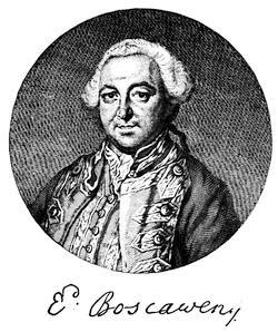
After an engraving by Ravenet. Cf. David Ramsay’s Mil. Memoirs of Great Britain, or a History of the War, 1755-1763 (Edinburgh, 1779), p. 192; and John Entick’s Hist. of the Late War, iii. p. 443.
Lord Loudon’s abortive attempt on Louisbourg has been mentioned in another place.[1031] Parkman gives the authorities. (Montcalm and Wolfe, i. 473; cf. Barry’s Massachusetts, ii. 223.)
An agreement (Sept. 12) for the supply of arms, etc., between sundry merchants and others of Maine and certain men, “for an intended scout or cruise for the killing and captivating the Indian enemy to the eastward,” to be under the command of Joseph Bayley, Jr., for sixty days from Sept. 20, 1757, is in the Maine Hist. and Geneal. Recorder, i. p. 11.
The journal (1758) of Captain Gorham’s rangers and other forces under Major Morris, in a marauding expedition to the Bay of Fundy, is given in the Aspinwall Papers, in Mass. Hist. Coll., xxxix. 222.
Franquet, who a year or two before the war began was sent by the French to strengthen Louisbourg and inspect the defences of Canada, kept a journal, which Parkman uses in his Montcalm and Wolfe.
Admiral Knowles, in the memorial for back pay which he presented in 1774 to the British government, claimed the credit of having planned the movements for this second capture of Louisbourg.
The most authoritative contemporary account of the siege of 1758, on the English side, is contained in the despatches of Amherst and Boscawen sent to Pitt, extracts from which were published as A journal of the landing of his majesty’s forces on the island of Cape Breton, and of the siege and surrender of Louisbourg (22 pp.). What is called a third edition of this tract was printed in Boston in 1758.[1032] The so-called journal of Amherst was printed in the London Magazine, and is included in Thomas Mante’s Hist. of the Late War in North America (London, 1772).
Of the contemporary French accounts, Parkman says he had before him four long and minute diaries of the siege. The first is that of Drucour, the French commander, containing his correspondence with Amherst, Boscawen, and Desgouttes, the naval chief of the French. Tourville, who commanded the “Capricieux,” one of the French fleet, kept a second of these diaries. A third and fourth are without the names of their writers. They agree in nearly all essential particulars.[1033] The Parkman MSS., in the Mass. Hist. Society’s library, contain many letters from participants in the siege, which were copied from the Paris Archives de la Marine. The manuscript of Chevalier Johnstone, a Scotch Jacobite serving with the French, gives an account of the siege, which is described elsewhere (post, in chapter viii.) and has been used by Parkman. The Documents Collected in France—Massachussetts Archives (vol. ix. p. i.) contains one of the narratives.
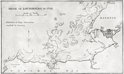
FROM BROWN’S CAPE BRETON.
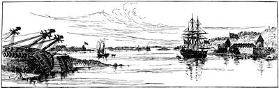
VIEW OF LOUISBOURG.
From the northeast. One of Des Barres’ coast views. (In Harvard College library.) Dr. A. H. Nichols, of Boston, possesses a plan of Louisbourg made by Geo. Follings, of Boston, a gunner in the service. He has also a contemporary sketch of the fort at Canso.
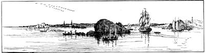
ENTRANCE TO LOUISBOURG HARBOR.
One of Des Barres’ coast views, 1779. (In Harvard College library.) A contemporary view showing the town from a point near the light-house is given in Cassell’s United States, i. 528.
The printed materials on the French side are not nearly so numerous as on the English. Of importance is Thomas Pichon’s[1034] Lettres et Mémoires pour servir à l’histoire du Cap Breton (a la Haye, 1760), of which there is an English translation, of the same year, purporting to be copied from the author’s original manuscript.[1035]
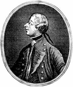
After the print in Entick’s Gen. Hist. of the Late War, 3d ed., vol. iv. p. 90. See the engraving from Knox’s journal, on another page, in ch. viii.
Of individual experiences and accounts there are, on the English side, John Montresor’s journal, in the Coll. of the N. Y. Hist. Soc., 1881 (p. 151);[1036] An Authentic Account of the Reduction of Louisbourg in June and July, 1758, by a Spectator (London, 1758),[1037] which Parkman calls excellent, and says that Entick, in his General History of the Late War (London, 1764),[1038] used it without acknowledgment. The same authority characterizes as admirable the account in John Knox’s Historical Journal of the Campaigns in North America, 1757-1760[1039] (vol. i. p. 144), with its numerous letters and orders relating to the siege. Wright, in his Life of Wolfe, gives various letters of that active officer. Parkman also uses a diary of a captain or subaltern in Amherst’s army, found in the garret of an old house at Windsor, Nova Scotia. Some contemporary letters will be found in the Grenville Correspondence (vol. i. pp. 240-265);[1040] and other views of that day respecting the event can be gleaned from Walpole’s Memoirs of George the Second (2d ed., vol. iii. 134).[1041] Of the modern accounts, the most considerable are those in Warburton’s Conquest of Canada (N. Y., 1850, vol. ii. p. 74), Brown’s History of Cape Breton, and the story as recently told with unusual spirit and acquaintance with the sources in Parkman’s Montcalm and Wolfe (vol. ii. chap. xix).
Amherst had wished to push up to Quebec immediately upon the fall of Louisbourg, but the news from Abercrombie and some hesitancy of Boscawen put an end to the hope. Chatham Correspondence, i. 331-333.
The reports of the capture reached London August 18. (Grenville Correspondence, i. p. 258.)
Jenkinson writes (Sept. 7, 1758), “Yesterday the colours that were taken at Louisbourg were carried in procession to Saint Paul’s; the mob was immense.” (Grenville Corresp., i. 265.)
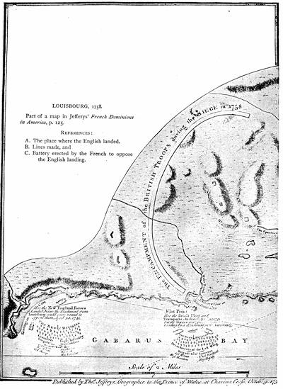
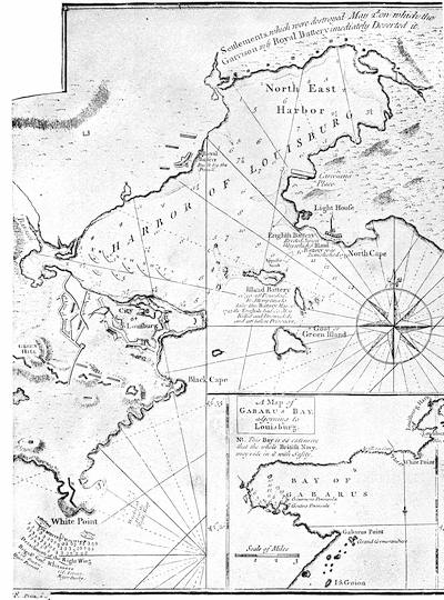
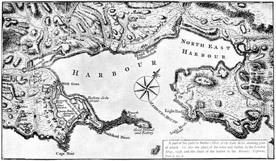
Speaking of Amherst’s success at Louisbourg, Burrows, in his Life of Lord Hawke (London, 1883, p. 340), says: “So entirely has the importance of this place receded into the background that it requires an effort to understand why the success of Boscawen and Amherst should have been thought worthy of the solemn thanks of Parliament, and why the captured colors of the enemy should have been paraded through the streets of London.”
Mr. William S. Appleton, in the Proc. Mass. Hist. Soc., vol. xi. pp. 297, 298, describes three medals struck to commemorate the siege of 1758. Cf. also Trans. Quebec Lit. and Hist. Soc., 1872-73, p. 79.
A view of Louisburg in North America, taken from near the light-house, when that city was besieged in 1758, is the title of a contemporary copperplate engraving published by Jefferys. (Carter-Brown, iii. p. 335.) Cf. the view in Cassell’s United States, i. 528.
The plan of the siege, here presented, is reproduced from Brown’s Hist. of Cape Breton (p. 297):—
Key: The French batteries to oppose the landing were as follows:—
C. One swivel. D. Two swivels. E. Two six-pounders. F. One twenty-pounder and two six-pounders. G. One seven-inch and one eight-inch mortar. H. Two swivels. I. Two six-pounders. K. Two six-pounders. N. Two twelve-pounders. O. Two six-pounders. P. Two twenty-four pounders. Q. Two six-pounders. R. Two twelve-pounders.
The points of attack were as follows:—
A. Landing of the first column. B. Landing of the second column.
These troops carried the adjacent batteries and pursued their defenders towards the city. The headquarters of the English were now established at H Q, while the position of the various regiments is marked by the figures corresponding to their numbers. Three redoubts (R 1, 2, 3) were thrown up in advance, and two block-houses (B H 1, 2) were built on their left flank; and later, to assist communication with Wolfe, who had been sent to the east side of the harbor, a third block-house (B H 3) was constructed. Then a fourth redoubt was raised at Green Hill (G H R 4) to cover work in the trenches. Meanwhile the English batteries at the light-house had destroyed the island battery, and the French had sunk ships in the channel to impede the entrance of the English fleet. The first parallel was opened at T, T1, T2, and a rampart was raised, E P, to protect the men passing to the trenches. Wolfe now erected a new redoubt at R 5, to drive off a French frigate near the Barachois, which annoyed the trenches; and another at R 6, which soon successfully sustained a strong attack. The second (T 3, 4) and third (T 5, 6) parallels were next established. A boat attack from the English fleet outside led to the destruction and capture of the two remaining French ships in the harbor, opening the way for the entrance of the English fleet. At this juncture the town surrendered.
Cf. also the plans in Jefferys’ Natural and Civil Hist. of the French Dominions in North America (1760), and in Mante’s Hist. of the War (annexed). Parkman, in his Montcalm and Wolfe, ii. 52, gives an eclectic map. Father Abraham’s Almanac, published at Philadelphia and Boston in 1759, has a map of the siege.
Treaty at Halifax of Governor Lawrence with the St. John and Passamaquoddy Indians, Feb. 23, 1760. (Mass. Archives, xxxiv.; Williamson, i. 344.)
Conference with the Eastern Indians at Fort Pownall, Mar. 2, 1760. (Mass. Archives, xxix. 478.)
Pownall’s treaty of April 29, 1760. Brigadier Preble’s letter, April 30, 1760, respecting the terms on which he had received the Penobscots under the protection of the government. (Mass. Archives, xxxiii.) Conference with the Penobscots at the council chamber in Boston, Aug. 22, 1763. (Mass. Archives, xxix. 482.) Cf. on the Indian treaties, Maine Hist. Soc. Collections, iii. 341, 359. The treaty of Paris had been signed Feb. 10, 1763.
THE MAPS AND BOUNDS OF ACADIA.
By the Editor.
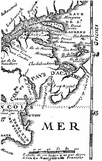
The cartography of Acadia begins with that coast, “discovered by the English,” which is made a part of Asia in the map of La Cosa in 1500.[1042] The land is buried beneath the waves, west of the land of the king of Portugal, in the Cantino map of 1502.[1043] It lies north of the “Plisacus Sinus,” as a part of Asia, in the Ruysch map of 1508.[1044] It is a vague coast in the map of the Sylvanus Ptolemy of 1511.[1045] For a long time the eastern coast of Newfoundland and neighboring shores stood for about all that the early map-makers ventured to portray; called at one time Baccalaos, now Corterealis, again Terra Nova; sometimes completed to an insular form, occasionally made to face a bit of coast that might pass for Acadia, often doubtless embracing in its insularity an indefinite extent that might well include island and main together, vaguely expressed, until in the end the region became angularly crooked as a part of a continental coast line. The maps which will show all this variety have been given in previous volumes. The Homem map of 1558[1046] is the earliest to give the Bay of Fundy with any definiteness. There was not so much improvement as might be expected for some years to come, when the map-makers followed in the main the types of Ruscelli and Ortelius, as will be seen by sketches and fac-similes in earlier volumes.
In 1592 the Molineaux globe of the Middle Temple[1047] became a little more definite, but the old type was still mainly followed. In 1609 Lescarbot gave special treatment to the Acadian region[1048] for the first time, and his drafts were not so helpful as they ought to have been to the more general maps of Hondius, Michael Mercator, and Oliva, all of 1613, but Champlain in 1612[1049] and 1613[1050] did better. The Dutch and English maps which followed began to develop the coasts of Acadia, like those of Jacobsz (1621),[1051] Sir William Alexander (1624),[1052] Captain Briggs in Purchas (1625),[1053] Jannson’s of 1626, and the one in Speed’s Prospect, of the same year.[1054] The Dutch De Laet began to establish features that lingered long[1055] with the Dutch, as shown in the maps of Jannson and Visscher; while Champlain, in his great map of 1632,[1056] fashioned a type that the French made as much of as they had opportunity, as, for instance, Du Val in 1677. Dudley in 1646[1057] gave an eclectic survey of the coast. After this the maps which pass under the names of Covens and Mortier,[1058] and that of Visscher with the Dutch, and the Sanson epochal map of 1656[1059] among the French, marked some, but not much, progress. The map of Heylin’s Cosmographie in 1663, the missionary map of the same year,[1060] and the new drafts of Sanson in 1669 show some variations, while that of Sanson is followed in Blome (1670). The map in Ogilby,[1061] though reëngraved to take the place of the maps in Montanus and Dapper,[1062] does not differ much.
ACADIA.
To complete the two centuries from La Cosa, we may indicate among the French maps a missionary map of 1680,[1063] that of Hennepin,[1064] the great map of Franquelin (1684),[1065] the “partie orientale” of Coronelli’s map of 1688-89,[1066] and the one given by Leclercq in the Établissement de la Foy (1691). The latest Dutch development was seen in the great Atlas of Blaeu in 1685.[1067]
With the opening of the eighteenth century, we have by Herman Moll, a leading English geographer of his day, a New Map of Newfoundland, New Scotland, the isles of Breton, Anticoste, St. Johns, together with the fishing bancks, which appeared in Oldmixon’s British Empire in America, in 1708,[1068] and by Lahontan’s cartographer the Carte générale de Canada, which appeared in the La Haye edition (1709) of his travels, repeated in his Mémoires (1741, vol. iii.). A section showing the southern bounds as understood by the French to run on the parallel of 43° 30′, is annexed.
From 1714 to 1722 we have the maps of Guillaume Delisle, which embody the French view of the bounds of Acadia.
In 1718 the Lords of Trade in England recognized the rights of the original settlers of the debatable region under the Duke of York,—which during the last twenty years had more than once changed hands,—and these claimants then petitioned to be set up as a province, to be called “Georgia.”[1069]
In 1720, Père Anbury wrote a Mémoire, which confines Acadia to the Nova Scotia peninsula, and makes the region from Casco Bay to Beaubassin a part of Canada.[1070]
In March, 1723, M. Bohé reviewed the historical evidences from 1504 down, but only allowed the southern coast of the peninsula to pass under the name of Acadia.[1071]
In 1731 the crown took the opinion of the law-officers as to the right of the English king to the lands of Pemaquid, between the Kennebec and the St. Croix, because of the conquest of the territory by the French, and reconquest causing the vacating of chartered rights; and this document, which is long and reviews the history of the region, is in Chalmers’ Opinions of Eminent Lawyers, i. p. 78, etc.
In 1732 appeared the great map of Henry Popple, Map of the British Empire in America and the French and Spanish settlements adjacent thereto. It was reproduced at Amsterdam about 1737. Popple’s large MS. draft, which is preserved in the British Museum,[1072] is dated 1727. When in 1755 some points of Popple told against their claim, the English commissioners were very ready to call the map inaccurate. We have the Acadian region on a small scale in Keith’s Virginia, in 1738. The Delisle map of North America in 1740 is reproduced in Mills’ Boundaries of Ontario (1873). The English Pilot of 1742, published at London, gives various charts of the coast, particularly no. 5, “Newfoundland to Maryland,” and no. 13, “Cape Breton to New York.”
Much better drafts were made when Nicolas Bellin was employed to draw the maps for Charlevoix’s Nouvelle France,[1073] which was published in 1744. These were the Carte de la partie orientale de la Nouvelle France ou du Canada (vol. i. 438), a Carte de l’Accadie dressée sur les manuscrits du dépost des cartes et plans de la marine (vol. i. 12),[1074] and a Carte de l’Isle Royale (vol. ii. p. 385), beside lesser maps of La Heve, Milford harbor, and Port Dauphin. These are reproduced in Dr. Shea’s English version of Charlevoix. Bellin’s drafts were again used as the basis of the map of Acadia and Port Royal (nos. 26, 27) in Le petit atlas maritime, vol. i., Amérique Septentrionale, par le S. Bellin (1764).
The leading English and French general maps showing Acadia at this time are that of America in Bowen’s Complete System of Geography (1747)[1075] and D’Anville’s Amérique Septentrionale (Paris), which was reëngraved, with changes, at Nuremberg in 1756, and at Boston (reprinted, London) 1755, in Douglass’s Summary of the British Settlements in North America. It is here called “improved with the back settlements of Virginia.”[1076]
The varying territorial claims of the French and English were illustrated in a Geographical History of Nova Scotia, published at London in 1749; a French version of which, as Histoire géographique de la Nouvelle Écosse, made by Étienne de Lafargue, and issued anonymously, was published at Paris in 1755, but its authorship was acknowledged when it was later included in Lafargue’s Œuvres.[1077] The Mémoire which Galissonière wrote in December, 1750, claimed for France westward to the Kennebec, and thence he bounded New France on the water-shed of the St. Lawrence and Mississippi.[1078] In 1750-51 Joseph Bernard Chabert was sent by the French king to rectify the charts of the coasts of Acadia, and his Voyage fait par ordre du Roi en 1750 et 1751 dans l’Amérique Septentrionale pour rectifier les cartes des côtes de l’Acadie, de l’îsle Royale, et de l’îsle de Terre Neuve, Paris, 1753, has maps of Acadia and of the coast of Cape Breton.[1079]
In 1753 the futile sessions of the commissioners of England and France began at Paris. Their aim was to define by agreement the bounds of Acadia as ceded to England by the treaty of Utrecht (1713),[1080] under the indefinite designation of its “ancient limits.” What were these ancient limits? On this question the French had constantly shifted their grounds. The commission of De Monts in 1603 made Acadia stretch from Central New Brunswick to Southern Pennsylvania, or between the 40th and 46th degrees of latitude; but, as Parkman says, neither side cared to produce the document. When the French held without dispute the adjacent continent, they never hesitated to confine Acadia to the peninsula.[1081] Equally, as interest prompted, they could extend it to the Kennebec, or limit it to the southern half of the peninsula. Cf. the Mémoire sur les limites de l’Acadie (joint à la lettre de Begon, Nov. 9, 1713), in the Parkman MSS. in Mass. Hist. Soc., New France, i. p. 9.
In July, 1749, La Galissonière, in writing to his own ministry, had declared that Acadia embraced the entire peninsula; but, as the English knew nothing of this admission, he could later maintain that it was confined to the southern shore only. Cf. again Fixation des limites de l’Acadie, etc., 1753, among the Parkman MSS. in Mass. Hist. Soc., New France, i. pp. 203-269.
On this question of the “ancient limits,” the English commissioners had of course their way of answering, and the New England claims were well sustained in the arguing of the case by Governor Shirley, of Massachusetts,[1082] who with William Mildmay was an accredited agent of the English monarch. The views of the opposing representatives were irreconcilable,[1083] and in 1755 the French court appealed to the world by presenting the two sides of the case, as shown in the counter memoirs of the commissioners, in a printed work, which was sent to all the foreign courts. It appeared in two editions, quarto (1755) and duodecimo (1756), in three and six volumes respectively, and was entitled Mémoires des Commissaires du Roi et de ceux de sa Majesté Britannique. Both editions have a preliminary note saying that the final reply of the English commissioners was not ready for the press, and so was not included.[1084] This omission gave occasion to the English, when, the same year (1755), they published at London their Memorials of the English and French commissaries concerning the limits of Nova Scotia or Acadia, to claim that, by including this final response of the English commissioners, their record of the conference was more complete. This London quarto volume[1085] contained various documents.[1086]
In 1757 a fourth volume was added to the quarto Paris edition, containing the final reply of the English commissioners, and completing the record of the two years’ conference. The four volumes are a very valuable repository of historical material; and, from printing at length the documents offered in evidence, it is a much more useful gathering than the single English volume, which we have already described. The points of difference between the two works are these:—
The memorial of Shirley and Mildmay (Jan. 11, 1751), given in French only in the Paris edition, and accompanied by observations of the French commissioners in foot-notes, is here given in French and English, but without the foot-notes. The English memorial of Jan. 23, 1753, lacks the observations of the French commissioners which accompany it in their vol. iv.[1087]
Among the “pièces justificatives” in the London edition, various papers are omitted which are given in the Paris edition. The reason of the omission is that they already existed in print. Such are the texts of various treaties, and extracts from printed books.
The London edition prints, however, the MS. sources among these proofs, but does not give the observations of the French commissioners which accompany them in the Paris edition. Among the papers thus omitted in the London edition are the provincial charter of Massachusetts Bay and Gen. John Hill’s manifesto, printed at Boston from Charlevoix.
Vol. iv. of the Paris edition has various additional “pièces produites par les commissaires du Roi,” including extracts from Hakluyt, Peter Martyr, Ramusio, Gomara, Fabian, Wytfliet, as well as the English charters of Carolina (1662-63, 1665) and of Georgia (1732).
The Paris edition was also reprinted at Copenhagen, with a somewhat different arrangement, under the title Mémoires des commissaires de sa Majesté très chrétienne et de ceux de sa Majesté Britannique. À Coppenhague, 1755.
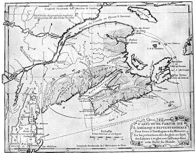
THE FRENCH CLAIM, 1755.
Key of the French Map: Limits proposed by English commissaries, Sept. 21, 1750, and Jan. 11, 1751 (exclusive of Cape Breton),------
By the treaty of Utrecht, ++++++
Port Royal district, by the same treaty,——————
Grant to Sir William Alexander, Sept. 10, 1621, ...........
Cromwell’s grant to La Tour, Crown, and Temple, Aug. 9, 1656, ══════
What was restored to France by the treaty of Breda includes Cromwell’s grant and the country from Mirlegash to Canseau.
Denys’ government (1654), shaded horizontally.
Charnesay’s government (1638), shaded obliquely.
La Tour’s government (1638), shaded perpendicularly.
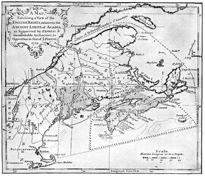
THE ENGLISH CLAIM, 1755.
Key of the English Map: Claim of the English under the treaty of Utrecht (1713), marked ——————
Grant to Sir William Alexander (1621), and divided by him into Alexandria and Caledonia, being all east of line marked ·─·─·─·─
According to Champlain (1603-1629), all, excepting Cape Breton, east of this line, ......
Grants of Louis XIII. and XIV. (1632-1710), the same as the claim of the English for Nova Scotia or Acadia.
Nova Scotia, enlarged westward to the Kennebec, as granted to the Earl of Sterling (Alexander).
Acadia proper, as defined by Charlevoix in accordance with the tripartite division, shaded perpendicularly.
Charnesay’s government (1638), ══════
La Tour’s government (1638), +++++++
Cromwell’s grant to La Tour, Crown, and Temple, being the same ceded to France by the treaty of Breda (1667), ———
Norembega, according to Montanus, Dapper, and Ogilby, is the country between the Kennebec and Penobscot.
The Etechemin region, as defined by Champlain and Denys, shaded obliquely.
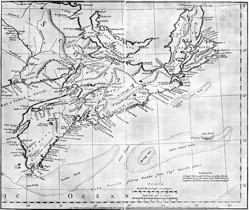
JEFFERYS’ NOVA SCOTIA.
All three of the editions in French have a map, marking off the limits of Acadia under different grants, and defining the claims of France. It is engraved on different scales, however, in the two Paris editions, and shows a larger extent of the continent westerly in the Copenhagen edition. The fourth volume of the quarto Paris edition has also a map, in which the bounds respectively of the charters of 1620, 1662, 1665, and 1732 (Virginia, Carolina, and Georgia), claimed by the English to run through to the Pacific, are drawn.[1088]
Thomas Jefferys, the English cartographer, published at London in 1754 his Conduct of the French with regard to Nova Scotia from its first settlement to the present time. In which are exposed the falsehood and absurdity of their arguments made use of to elude the force of the treaty of Utrecht, and support their unjust proceedings. In a letter to a member of Parliament.[1089]
The map of the French claims and another of the English claims are copied herewith from Jefferys’ reproduction of the former and from his engraving of the latter, both made to accompany his later Remarks on the French Memorials concerning the limits of Acadia, printed at the Royal Printing-House at Paris, and distributed by the French ministers at all the foreign courts of Europe, with two maps exhibiting the limits: one according to the system of the French, the other conformable to the English rights. To which is added An Answer to the Summary Discussion,[1090] etc. London, T. Jefferys, 1756.[1091]
Both of these Jefferys maps were included by that geographer in his General Topography of North America and the West Indies, London, 1768, and one of them will also be found in the Atlas Amériquain, 1778, entitled “Nouvelle Écosse ou partie orientale du Canada, traduitte de l’Anglais de la Carte de Jefferys publiée à Londres en May, 1755. A Paris par Le Rouge.” Jefferys also included in the London edition of the Memorials (1755) a New map of Nova Scotia and Cape Britain, with the adjacent parts of New England and Canada,[1092] which is also found in his History of the French Dominion in North and South America, London, 1760, and also in his General Topography, etc. A section of this map, showing Acadia, is reproduced herewith.[1093]
The great map of D’Anville in 1755[1094] enforced the extreme French claim, carrying the boundary line along the height of land from the Connecticut to Norridgewock, thence down the Kennebec to the sea. The secret instructions to Vaudreuil this same year (1755) allow that the French claim may be moved easterly from the Sagadahock to the St. Georges, and even to the Penobscot, if the English show a conciliatory disposition, but direct him not to waver if the water-shed is called in question at the north.[1095]
A German examination of the question appeared at Leipzig in 1756, in Das Brittische Reich in Amerika ... nebst nachricht von den Gränzstreitigkeiten und Kriege mit den Franzossen. It is elucidated with maps by John Georg Schrübers.[1096]