Part 2 — CHAPTER V. (continued 2)
Reading edition
There appears to be no uniformity in the spelling of the name of Groseilliers. Under May, 1662, is this entry: “I departed from Quebek on the 3d for Three Rivers; there met Des Grosillers, who was going to the Sea of the North. He left Quebek the night before with ten men.” Under August, 1663, is the following: “The 5th returned those who had been three years among the Outaoouac; nine Frenchmen went, and seven returned. The Father Menar and his man, Jean Guerin, one of our donnés, had died,—the Father Menar the 7th or 8th of August, 1661, and Jean Guerin in September, 1662. The party arrived at Montreal on the 25th of July, with thirty-five canoes and one hundred and fifty men.” Of Creuxius’ Historia and its relations to the missionaries’ reports, there is an account in the next chapter.
1660-1680.—The documents from the French archives in the Parliament Library at Ottawa, Canada (copies in manuscript), and those translated and printed in the New York Col. Docs., vol. ix., give much information on this period; and so do the Jesuit Relations, and the first volume of the Collections edited by Margry and published at Paris in 1875.[532]
The Mémoire sur les Mœurs, Coustumes, et Réligion des Sauvages de l’Amérique septentrionale, par Nicolas Perrot, publié pour la première fois par le R. P. J. Tailhan, de la Compagnie de Jésus, Leipsic and Paris, 1864,[533] was examined by Charlevoix one hundred and fifty years ago, when it was in manuscript, and afforded him useful information. It is the only work referring to the traders at the extremity of Lake Superior between 1660 and 1670, and to the migrations of the Hurons from the Mississippi to the Black River, and from thence to Lake Superior. Much of interest is also derived from the Histoire de l’Amérique septentrionale. Par M. de Bacqueville de la Potherie, Paris, 1722, 4 vols.[534]
1680-1690.—There are differences of statements regarding the Upper Mississippi Valley, but nevertheless much information of importance, in the letter of La Salle from Fort Frontenac, in August, 1682,[535] in Du Lhut’s Mémoire of 1683, as printed by Harrisse,[536] and in Hennepin’s Description de la Louisiane.[537]
Perrot, in the work already quoted, gives the best account of this region from 1683 to 1690.
For the whole period of the exploration of the Great Lakes, the works among the secondary authorities of the chief value are Charlevoix in the last century, and Parkman in the present; but their labors are commemorated elsewhere.

EDITORIAL NOTE.
THE local historical work of the Northwest has been done in part under the auspices of various State and sectional historical societies. The Ohio Society, organized in 1831, became later inanimate, but was revived in 1868, and ought to hold a more important position among kindred bodies than it does. Mr. Baldwin has given an account of the historical and pioneer societies of Ohio in the Western Reserve and Northern Ohio Historical Society’s Tracts, no. 27; and this latter Society, organized in 1867, with the Licking County Pioneer Historical Society, organized the same year, and the Firelands Historical Society, organized in 1857, have increased the historical literature of the State by various publications elucidating in the main the settlements of the last century. The youngest of the kindred associations, the Historical and Geographical Society of Toledo, was begun in 1871. The State, however, is fortunate in having an excellent Bibliography of Ohio (1880), embracing fourteen hundred titles, exclusive of public documents, which was compiled by Peter G. Thomson; while the Americana Catalogues of Robert Clarke & Co., of Cincinnati, are the completest booksellers’ lists of that kind which are published in America. The Ohio Valley Historical Series, published by the same house, has not as yet included any publication relating to the period of the French claims to its territory. The earliest History of Ohio is by Caleb Atwater, published in 1838; but the History by James W. Taylor—“First Period, 1650-1787”—is wholly confined to the Jesuits’ missions, the wars of the Eries and Iroquois, and the later border warfare. (Field, Indian Bibliography, no. 1,535.) Henry Howe’s Historical Collections of Ohio, originally issued in 1848, and again in 1875, is a repository of facts pertaining for the most part to later times.
The Historical Society of Indiana, founded in 1831, hardly justifies its name, so far as appears from any publications. The chief History of Indiana is that by John B. Dillon, which, as originally issued in 1843, came down to 1816; but the edition of 1859 continues the record to 1856. The first three chapters are given to the French missionaries and the natives. (Field, Indian Bibliography, nos. 429, 430; Sabin, vol. v. no. 20,172.) A popular conglomerate work is The Illustrated History of Indiana, 1876, by Goodrich and Tuttle. A few local histories touch the early period, like John Law’s Colonial History of Vincennes, 1858; Wallace A. Brice’s History of Fort Wayne, 1868; H. L. Hosmer’s Early History of the Maumee Valley, Toledo, 1858; and H. S. Knapp’s History of the Maumee Valley from 1680, Toledo, 1872, which is, however, very scant on the early history.
In Illinois there is no historical association to represent the State; but the Historical Society of Chicago (begun in 1856), though suffering the loss of its collections of seventeen thousand volumes in the great fire of 1871, still survives.
The principal histories of the State touching the French occupation are Henry Brown’s History of Illinois, New York, 1844; John Reynolds’s Pioneer History of Illinois, Belleville, 1852, now become scarce; and Davidson and Stuvé’s Complete History of Illinois, 1673-1873, Springfield, 1874. The Historical Series issued by Robert Fergus pertain in large measure to Chicago, and, except J. D. Caton’s “Last of the Illinois, and Sketch of the Potawatomies,” has, so far as printed, little of interest earlier than the English occupation. H. H. Hurlbut’s Chicago Antiquities, 1881, has an account of the early discovery of the portage.
The Michigan Pioneer Society was founded in 1874, and has printed three volumes of Pioneer Collections, 1877-1880. The Houghton County Historical Society, devoting itself to the history of the region near Lake Superior,[538] dates from 1866. It has published nothing of importance. The State of Michigan secured, through General Cass, while he was the minister of the United States at Paris, transcripts of a large number of documents relating to its early history. The Historical Society of Michigan was begun in 1828, and during the few years following it printed several Annual Addresses and a volume of Transactions. Every trace of the Society had nearly vanished, when in 1857 it was revived. (Historical Magazine, i. 353.) The principal histories of the State are James H. Lanman’s History of Michigan, New York, 1839; Electra M. Sheldon’s Early History of Michigan, from the First Settlement to 1815, New York, 1856, which is largely given to an account of the Jesuit missions;[539] Charles R. Tuttle’s General History of Michigan, Detroit, 1874; James Valentine Campbell’s Outlines of the Political History of Michigan, Detroit, 1876. (Cf. Clarke’s Bibliotheca Americana, 1878, p. 92; 1883, p. 169; Sabin, Dictionary, vol. xii. p. 141.) A few of the sectional histories, like W. P. Strickland’s Old Mackinaw, Philadelphia, 1860, touch slightly the French period. A brief sketch of Mackinaw Island by Lieutenant Dwight H. Kelton, U. S. A., includes extracts from the registers of the Catholic Church at Mackinaw, and a list of the French commanders at that post during the eighteenth century.
The Historical Society of Wisconsin was founded in 1849, and reorganized in 1854. It has devoted itself to forming a large library, and has published nine volumes of Collections, etc. (Joseph Sabin in American Bibliopolist, vi. 158; Field, Indian Bibliography, no. 1,688). Mr. D. S. Durrie published a bibliography of Wisconsin in Historical Magazine, xvi. 29, and a tract on the Early Outposts of Wisconsin in 1873. A paper on the “First Page of the History of Wisconsin” is in the American Antiquarian, April, 1878. The principal histories of the State are I. A. Lapham’s Wisconsin, Milwaukee, 1846, which lightly touches the earliest period; William R. Smith’s Wisconsin (vol. i., historical; vol. ii., not published; vol. iii., documentary, translating in part the Jesuit Relations from the set in Harvard College Library), Madison, 1854; and Charles R. Tuttle’s Illustrated History of Wisconsin, Madison and Boston, 1875.
The Minnesota Historical Society was organized in 1849, and began the publication of its Annals in 1850, completing a volume in 1856. This volume was reissued in 1872 as vol. i. of its Collections, and includes papers on the origin of the name of Minnesota and the early nomenclature of the region, and papers by Mr. Neill on the French Voyageurs, the early Indian trade and traders,[540] and early notices of the Dakotas. In vol. ii. Mr. Neill has a paper on “The Early French Forts and Footprints in the Valley of the Upper Mississippi;”[541] and Mr. A. J. Hill has examined the geography of Perrot so far as it relates to Minnesota territory. In vol. iii. there is a bibliography of the State; in vol. iv., a History of St. Paul, by John Fletcher Williams, which but briefly touches the period of exploration. The State Historical Society of Minnesota lost a considerable part of its collections in the fire of March 11, 1881, which burned the State capitol,—as detailed in its Report for 1883.
The principal and sufficient account of the State’s history is Edward D. Neill’s History of Minnesota from the Earliest French Explorations, Philadelphia, 1858, which in 1883 reached an improved fifth edition, and is supplemented by his Minnesota Explorers and Pioneers, 1659-1858, published in 1881. In 1858 an edition was also issued, of one hundred copies, on large paper, illustrated with forty-five quarto steel plates, engraved from paintings chiefly by Captain Seth Eastman, U. S. Army.
The Historical Society of Iowa was founded in 1857, and began the publication of its Annals in 1863. The principal account of the State is C. R. Tuttle and D. S. Durrie’s Illustrated History of Iowa, Chicago, 1876.
There are a few more general works to be noted: John W. Monette’s History of the Discovery and Settlement of the Valley of the Mississippi, New York, 1846-1848;[542] S. P. Hildreth’s Pioneer History of the Ohio Valley, Cincinnati, 1848, which but cursorily touches the French period; James H. Perkins’s Annals of the West, Cincinnati, 1846, which brought ripe scholarship to the task at a time before the scholar could have the benefit of much information now accessible;[543] Adolphus M. Hart’s History of the Discovery of the Valley of the Mississippi, Cincinnati, 1852,—a slight sketch, as we now should deem it, but followed soon after by a more scholarly treatment in J. G. Shea’s Discovery and Exploration of the Mississippi Valley, New York, 1852, to which a sequel, Early Voyages up and down the Mississippi, was published in 1861, containing the voyages of Cavelier, Saint Cosme, Le Sueur, Gravier, and Guignas, during the last years of the century; George Gale’s Upper Mississippi, Chicago, 1867,—a topical treatment of the subject; and Rufus Blanchard’s Discovery and Conquests of the Northwest, Chicago, 1880—the latest general survey of the subject. Poole’s Index to Periodical Literature, under the names of these several States, can often be usefully consulted.
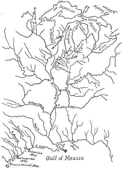
THE ROUTES OF EARLY FRENCH EXPLORATIONS.
This sketch follows a modern map given by Parkman. There is a similar route-map given in the Bulletin de la Soc. de Géog., November, 1880, accompanying a paper by M. J. Thoulet. In the above sketch the portages are marked by dotted lines.
JOLIET, MARQUETTE, AND LA SALLE.
HISTORICAL SOURCES AND ATTENDANT CARTOGRAPHY.
BY THE EDITOR.
THE principal sources for the cartographical part of this study are as follows: The collection of manuscript copies[544] of maps in the French Archives which was formed by Mr. Parkman, and which he has described in his La Salle (p. 449), and which is now in Harvard College Library; a collection of manuscript and printed maps called Cartographie du Canada, formed by Henry Harrisse in Paris, and which in 1872 passed into the hands of Samuel L. M. Barlow, Esq., of New York, by whose favor the Editor has had it in his possession for study; the collection of copies made by Dr. J. G. Kohl which is now in the Library of the State Department at Washington, and which through the kind offices of Theodore F. Dwight, Esq., of that department, and by permission of the Secretary of State, have been intrusted to the Editor’s temporary care; and the collection of printed maps now in Harvard College Library, formed mainly by Professor Ebeling nearly a hundred years ago, and which came to that library, with all of Ebeling’s books, as a gift from the late Colonel Israel Thorndike, in 1818.[545]
The completest printed enumeration of maps is in the section on “Cartographie” in Harrisse’s Notes pour servir à l’histoire ... de la Nouvelle France, 1545-1700, Paris, 1872, and this has served the Editor as a convenient check-list. A special paper on “Early Maps of Ohio and the West” constitutes no. 25 of the Tracts of the Western Reserve and Northern Ohio Historical Society. It was issued in 1875, and has been published separately, and is the work of Mr. C. C. Baldwin, secretary of that Society, whose own collection of maps is described by S. D. Peet in the American Antiquarian, i. 21. See also the Transactions (1879) of the Minnesota Historical Society.
The main guide for the historical portion of this essay has been the La Salle of Parkman.[546]
There are in the Dépôt de la Marine in Paris two copies of a rough sketch on parchment, showing the Great Lakes, which were apparently made between 1640 and 1650. They have neither maker’s name nor date, but clearly indicate a state of knowledge derived from the early discovery of the Upper Lakes by way of the Ottawa, and before the southern part of Lake Huron had been explored, and found to connect with Lake Erie. The maker must have been ignorant of the knowledge, or discredited it, which Champlain possessed in 1632 when he connected Ontario and Huron. Indications of settlements at Montreal would place the date of this map after 1642; and it may have embodied the current traditions of the explorations of Brulé and Nicolet, though it omits all indications of Lake Michigan, which Nicolet had discovered. Though rude in many ways, it gives one of the earliest sketches of the Bras d’Or in Cape Breton. The channel connecting the Atlantic and the St. Lawrence, if standing for anything, must represent the Connecticut and the Chaudière. Dr. Kohl, in a marginal note on a copy of this map in his Washington Collection, while referring to the uninterrupted water-way by the Ottawa, remarks on a custom, not uncommon on the early maps, of leaving out the portages; and the same suspicion may attach to the New England water-way here given. A note on the map gives the distance as three hundred leagues from Gaspé to the extremity of Lake Ontario; two hundred more to the land of the buffaloes; two hundred additional to the region of apes and parrots; then four hundred to the Sea of New Spain; and thence fifteen or sixteen hundred more to the Indies. A legend in the neighborhood of Lake Superior confirms other mention of the early discovery of copper in that region: “In the little lake near the mountains are found pieces of copper of five and six hundred pounds’ weight.”
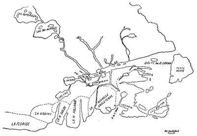
THE OTTAWA ROUTE, 1640-1650.
At a later day La Salle had learned, from some Senecas who visited his post at Lachine, of a great river, rising in their country and flowing to the sea; and, with many geographers of his day, captivated with a promised passage to India, he preferred to believe that it emptied into the Gulf of California.[547]
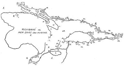
DOLLIER AND GALLINÉE’S EXPLORATIONS.
This is a reduced sketch of no. 1 of Mr. Parkman’s maps, which measures 30 × 50 inches. It has two titles: Carte du Lac Ontario et des habitations qui l’environne, ensemble les pays que Messrs Dolier et Galiné, missionnaires du séminaire de St. Sulpice, ont parcouru, and Carte du Canada et des terres decouvertes vers le lac Derié. Voir la lettre du M. Talon du 10 9bre, 1670. The figures stand for the following names and legends:—
1. C’est ici qu’ils ont un fort Bel Establissement, une belle maison, et de grands dezerts semés de bled francois et de bled d’inde, pois et autres graines [referring to 70].
2. Baye des Puteotamites. Il y a dix Journées de Chemin du Sault ou sont les RR. S. PP. JJ. aux puteotamites, c’est a dire environ 150 lieues. Je n’ay entré dans cette Baye que jusques a ces Iles que J’ay marquées.
3. Ce lac est le plus grand de tous ceux du pays.
4. C’est icy qu’estoit une pierre qu’avoit tres peu de figures d’hommes, qui les Iroquois tenoient pour un grand Capne, et a qui ils faisoient des sacrifices lorsqu’ils passoient par icy pour aller en guerre. Nous l’avons mis en pieces et jetté à l’eau.
5. Lac Derié, je non marque que ce que j’en ay veu en attendant que je voie le reste.
6. Grandes prairies.
7. Presqu’isle du lac D’Erie.
8. Prairies. Terres excellentes.
9. C’est icy que nous avons hyverne en le plus beau lieu que j’aye yen en Canada, pour l’abondance des arbres, fruittiers, aces, raisins, qui sy grande qu’on en pourroit vivre en faisant provision, grand chasse de serfs, Bisches, Ours, Schenontons, Chats, Sauvages, et Castors.
10. Grand chasse a ce petit misseau.
11. Toutes ces costes sont extremt pierreuses et ne laissent pas d’y avoir des bestes.
12. C’est dans cette Baye que estoit autrefois le pays de Hurons lorsqu’ils furent defaits par les Iroquois, et ou les RR. PP. Jesuites estoient fort bien establis.
13. Je n’ay point vu cette ance ou estoit autrefois le pays des Hurons, mais je vois qu’elle est encore plus profonde que je ne la desseins, et c’est icy apparamment qu’aboutit le chemin par ou Mr. Perray a passé.
14. L’embouchure de cette rivière fort difficile a trouver a neanmoins la petite isle qui la precede est fort remarquable par la grande quantité de ces isles de roche dont elle est composée qui deboutent fort loin au large.
17. Chasse d’originaux Bans ces isles.
18. Amikoue.
20. Portage trainage.
21. Sault. C’est dans cette Ance que les Nipissiriniens placent pour l’ordinaire leur village. Portage, 600 pas.
22. Lac des Nipissiriniens ou des Sorciers.
24. Rivier des vases.
24-25. In this space various portages are marked.
26. On entre icy dans la grande Riviere.
27. Mataouan.
28. C’est d’icy que Mr. Perray et sa Compagnie ont campé pour entrer dans le lac des Hurons, quand j’aurray vu le passage je le donneray mais toujours dit-on que le chemin est fort beau, et c’est icy que s’establiront les missionnaires de St. Sulpice.
29. Ganatse kiagourif.
30. Village de tanaouaoua.
31. C’est a ce village qu’estoit autrefois Neutre. Grand partie sesche par tout icy et tout le long de la R. rapide.
32. Bonne Terre.
33. Grand chasse. Prairies siches.
34. R. Rapide ou de Tinaatoua.
35. Il y a le long de ces ances quantité de petits lacs separés seulement du grand par des Chaussées de Sable. C’est dans ces lacs que les Sanountounans prennent quantité de poisson.
36. Sault qui tombe au rapport des Sauvages de plus de 200 pieds de haut.
37. Excellente terre.
38. Petit lac d’Erie.
39. Sault ou il y a grande pesche de barbues.
40. Gaskounchiakons.
41. Excellente terre. Village du R. P. Fremin. 4 villages des Sonountouans, les des grands sont chacun de 100 Cabannes et les autres d’environ 20 a 25 sans aucune fortification non pas mesme naturelle; il faut mesme qu’ils aillent chercher l’eau fort loing.
42. Il y a de l’alun au pied de cette montagne fortaine de bitume. Excellente terre.
43. R. des Amandes et doneiout. R. des Oiogouins.
44. Abondance de gibier dans cette riviere. Quoyqu’il ne paroisse icy que des Sables sur le bord du lac. Ces terres ne laissent pas d’etre bonnes dans la profondeur. R. Denon taché.
45. Kahengouetta. Kaouemounioun.
46. Otondiata.
47. Pesche d’anguille tout au travers de la riviere.
48. Islets de roches.
49. Depuis icy Jusques a Otondiata il y a de forts rapides a toutes les pointes, et des remouils dans toutes les ances.
50. Lac St. Francois.
51. Habitation des RR. PP. Jesuites.
52. La Madelaine.
53. Lac St. Louis.
54. Habitation du Montreal.
55. Lac des 2 montagnes.
56. Belle terre. Terres nayées. Bonnes terres. Il faut faire 5 portages du Costé du Nord portage pour monter au lac St. François, mais du costé du sud on n’en fait qu’un.
57. Long sault.
58. Ces 2 rivieres en tombant dans la grande font 2 belles nappes, portage 50 pas.
59. L’estoit icy qu’estoit autrefois la petite nation Algonquine.
60. Portage du sault de la Chaudiere 300 pas.
61. L’estoit icy ou estoit le fameus Borgne de l’isle dans les relations des RR. PP. Jesuites.
62. Le grand portage du sault des Calumets est de ce costé, pour l’eviter nous prismes de l’autre coste.
63. Il faut faire 5 portages de ce costé icy d’environ 100 pas chacun.
64. Portage apellé des alumettes 200 pas.
65. Tres grande chasse d’originaux autour de ce petit lac.
66. On dit que cette branche de la grande Riviere va aux trois rivières.
67. Grand rapides.
68. Portage 200 pas.
69. Lac Superieur.
70. Fort des S. RRnds PP. Jesuites. Sauteurs.
71. Anipich.
72. R. de Tessalon. Mississague.
There are in the Kohl Collection, in the Department of State, two maps of Lake Ontario, of 1666, the original of one of which is credited to the Dépôt de la Marine.
He was determined to track it; and gaining some money by selling his grant at Lachine, and procuring the encouragement of Talon and Courcelles, he formed an alliance for the journey with two priests of the Seminary at Montreal, Dollier de Casson and Galinée, who were about going westward on a missionary undertaking. La Salle started with them on the 6th of July, 1669, with some followers, and a party of Senecas as guides. The savages led them across Lake Ontario to a point on the southern shore nearest to their villages, which the party visited in the hope of securing other guides to the great river of which they were in search. Failing in this, they made their way to the western extremity of the lake, where they fell in with Joliet, as mentioned in the preceding chapter. La Salle now learned Joliet’s route; but he was not convinced that it opened to him the readiest way to the great river of the Indians, though the Sulpitians were resolved to take Joliet’s route north of Lake Erie. When these priests returned to Montreal, in June, 1670, they brought back little of consequence, except the data to make the earliest map which we have of the Upper Lakes, and of which a sketch is given herewith.
This map of Galinée, says Parkman,[548] was the earliest attempt after Champlain to portray the great lakes. Faillon, who gives a reproduction of this map,[549] says it is preserved in the Archives of the Marine at Paris; but Harrisse[550] could not find it there. There is a copy of it, made in 1856 from the original at Paris, in the Library of Parliament at Ottawa.[551] Faillon[552] gives much detail of the journey, for the Sulpitians were his heroes; and Talon made a report;[553] but the main source of our information is Galinée’s Journal, which is printed, with other papers appertaining, by Margry,[554] and by the Abbé Verreau.[555]
The Michigan peninsula, which Galinée had failed to comprehend, is fully brought out in the map of Lake Superior which accompanies the Jesuit Relation of 1670-1671.[556] Mr. Parkman is inclined to consider a manuscript map without title or date, but called in the annexed sketch “The Lakes and the Mississippi” (from a copy in the Parkman Collection), as showing “the earliest representation of the upper Mississippi, based perhaps on the reports of the Indians.”[557] He calls it the work of the Jesuits, whose stations are marked on it by crosses. It seems however to be posterior to the time when Joliet gave the name Colbert to the Mississippi.
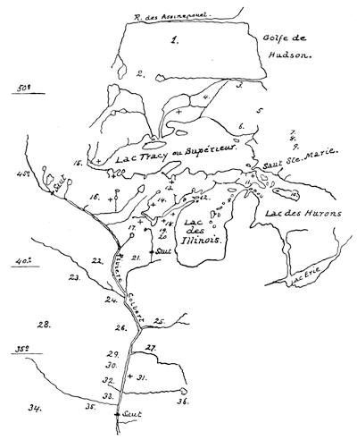
THE LAKES AND THE MISSISSIPPI.
This map bears legends or names corresponding to the following key: 1. Les Kilistinouk disent avoir veu un grand naviere qui hiverna à l’embouchure de ce fleuve; ils auroient fait une maison d’un coste et de l’autre un fort de bois. 2. Assinepouelak. 3. Oumounsounick. 4. Ounaouantagouk. 5. Chiligouek. 6. Outilibik. 7. Noupining-dachirinouek. 8. Ouchkioutoulibik. 9. Missisaking-dachiri-nouek. 10. Outaouak. 11. Michilimakinak. 12. Baye des Puans. 13. Oumalouminek. 14. Outagamik. 15. Nadouessi. 16. Icy mourut le P. Meynard. 17. Kikabou. 18. Ouenebegouk. 19. Pouteoutamic. 20. Ousakie. 21. Illinouek Kachkachki. 22. Mouingouea. 23. Ouchachai. 24. Ouemissirita. 25. Chaboussioua. 26. Pelissiak. 27. Monsoupale. 28. Paniassa. 29. Taaleousa. 30. Metchagamea. 31. Akenza. 32. Matorea. 33. Tamikoua. 34. Ganiassa. 35. Minou. 36. Kachkinouba.
What La Salle did after parting with the Sulpitians in 1669 is a question over which there has been much dispute. The absence of any definite knowledge of his movements for the next two years leaves ample room for conjecture, and Margry believes that maps which he made of his wanderings in this interval were in existence up to the middle of the last century. It is from statements regarding such maps given in a letter of an aged niece of La Salle in 1756, as well as from other data, that Margry has endeavored to place within these two years what he supposes to have been a successful attempt on La Salle’s part to reach the Great River of the West. If an anonymous paper (“Histoire de Monsieur de la Salle”) published by Margry[558] is to be believed, La Salle told the writer of it in Paris,—seemingly in 1678,—that after leaving Galinée he went to Onondaga (?), where he got guides, and descending a stream, reached the Ohio (?), and went down that river. How far? Margry thinks that he reached the Mississippi: Parkman demurs, and claims that the story will not bear out the theory that he ever reached the mouth of the Ohio; but it seems probable that he reached the rapids at Louisville, and that from this point he retraced his steps alone, his men having abandoned him to seek the Dutch and English settlements. Parkman finds enough amid the geographical confusions of this “Histoire” to think that upon the whole the paper agrees with La Salle’s memorial to Frontenac in 1677, in which he claimed to have discovered the Ohio and to have coursed it to the rapids, and that it confirms the statements which Joliet has attached to the Ohio in his maps, to the effect that it was by this stream La Salle went, “pour aller dans le Mexique.”[559]
The same “Histoire” also represents that in the following year (1671) La Salle took the course in which he had refused to follow Galinée, and entering Lake Michigan, found the Chicago portage, and descending the Illinois, reached the Mississippi. This descent Parkman is constrained to reject, mainly for the reason that from 1673 to 1678 Joliet’s claim to the discovery of the Mississippi was a notorious one, believed by Frontenac and by all others, and that there was no reason why La Salle for eight years should have concealed any prior knowledge. The discrediting of this claim is made almost, if not quite, conclusive by no mention being made of such discovery in the memorial of La Salle’s kindred to the King for compensation for his services, and by the virtual admission of La Salle’s friends of the priority of Joliet’s discovery in a memorial to Seignelay, which Margry also prints.[560]
In 1672 some Indians from the West had told Marquette at the St. Esprit mission of a great river which they had crossed. Reports of it also came about the same time to Allouez and Dablon, who were at work establishing a mission at Green Bay; and in the Relation of 1672 the hope of being able to reach this Mississippi water is expressed.
Frontenac on his arrival felt that the plan of pushing the actual possession of France beyond the lakes was the first thing to be accomplished, and Talon, as we have seen, on leaving for France recommended Joliet[561] as the man best suited to do it. Jacques Marquette joined him at Point St. Ignace. The Jesuit was eight years the senior of the fur-trader, and of a good family from the North of France.
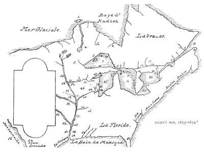
JOLIET’S MAP, 1673-1674.
Key: 1. Les sauvages habitent cette isle. 2. Sauvages de la mer. 3. Kilistinons. 4. Assiniboels. 5. Madouesseou. 6. Nations du nord. 7. Lac Supérieur. 8. Le Sault St. Marie. 9. Missilimakinak. 10. Kaintotan. 11. Lac Huron. 12. Nipissing. 13. Mataouan. 14. Tous les poincts sont des rapides. 15. Les trois rivieres. 16. Tadoussac. 17. Le Saguenay. 18. Le Fleuve de St. Laurent. 20. Montroyal. 21. Fort de Frontenac. 22. Lac Frontenac ou Ontario. 24. Sault, Portage de demi lieue. 25. Lac Erie. 26. Lac des Illinois ou Missihiganin. 27. Cuivre. 28. Kaure. 29. Baye des Puans. 30. Puans. 31. Maskoutins. 32. Portage. 33. Riviere Miskonsing. 34. Mines de fer. 35. Riviere de Buade. 36. Kitchigamin. 37. Ouaouiatanox. 38. Paoutet, Maha, Pana, Atontanka, Illinois, Peouarea, 300 Cabanes, 180 Canots de bois de 50 pieds de long. 39. Minongio, Pani, Ouchagé, Kansa, Messouni. 40. La Frontenacie. 41. Pierres Sanguines. 42. Kachkachkia. 43. Salpetre. 44. Riviere de la Divine ou l’Outrelaize. 45. Riv. Ouabouskigou. 46. Kaskinanka, Ouabanghihasla, Malohah. 47. Mines de fer; Chouanons, terres eiseléez, Aganatchi. 48. Akansea sauvages. 49. Mounsoupria. 50. Apistonga. 51. Tapensa sauvages. 52 and 53 (going up the stream which is called Riviere Basire). Atatiosi, Matora, Akowita, Imamoueta, Papikaha, Tanikoua, Aiahichi, Pauiassa. 54. Europeans. 55. Cap de la Floride. 56. Mer Vermeille, ou est la Califournie, par ou on peut aller au Perou, au Japon, et à la Chine.
Their course has been sketched in the preceding chapter. They seemed to have reached a conviction that the Great River flowed into the Gulf of Mexico. Their return was by the Illinois River and the Chicag portage.[562] During the four months of their absence, says Parkman, they had paddled their canoes somewhat more than two thousand five hundred miles.
While Marquette remained at the mission Joliet returned to Quebec. What Joliet contributed to the history of this discovery can be found in a letter on his map, later to be given in fac-simile; a letter dated Oct. 10, 1674, given by Harrisse;[563] the letter of Frontenac announcing the discovery, which must have been derived from Joliet,[564] and the oral accounts which Joliet gave to the writer of the “Détails sur le voyage de Louis Joliet; and a Relation de la descouverte de plusieurs pays situez au midi de la Nouvelle France, faite en 1673,” both of which are printed by Margry.[565]
Within a few years there has been produced a map which seems to have been made by Joliet immediately after his return to Montreal. This would make it the earliest map of the Mississippi based on actual knowledge, and the first of a series accredited to Joliet. It is called Nouvelle découverte de plusieurs nations dans la Nouvelle France en l’année 1673 et 1674. Gabriel Gravier first made this map known through an Étude sur une carte inconnue; la première dressée par L. Joliet en 1674, après son exploration du Mississippi auec Jacques Marquette en 1673.[566] A sketch of it, with a key, is given herewith. The tablet in the sketch marks the position of Joliet’s letter to Frontenac, of which a reduced fac-simile is also annexed.
“In this epistle,” says Mr. Neill, “Joliet mentions that he had presented a map showing the situation of the Lakes upon which there is navigation for more than 1,200 leagues from east to west, and that he had given to the great river beyond the Lakes, which he had discovered in the years 1673-1674, the designation of Buade, the family name of Frontenac.[567] He adds a glowing description of the prairies, the groves, and the forests,” and writes of the quail (cailles) in the fields and the parrot (perroquet) in the woods. He concludes his communication as follows: “By one of the large rivers which comes from the west and empties into the River Buade, one will find a route to the Red Sea” [Mer vermeille, i. e. Gulf of California].
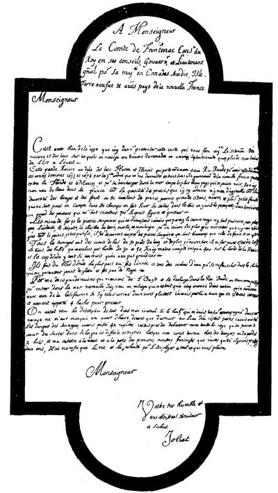
“I saw a village which was not more than five days’ journey from a tribe which traded with the tribes of California;[568] if I had arrived two days before, I could have conversed with those who had come from thence, and had brought four hatchets as a present. You would have seen a description of these things in my Journal, if the success which had accompanied me during the voyage had not failed me a quarter of an hour before arriving at the place from which I had departed. I had escaped the dangers from savages, I had passed forty-two rapids, and was about to land with complete joy at the success of so long and difficult an enterprise, when, after all dangers seemed past, my canoe turned over. I lost two men and my box in sight of the first French settlement, which I had left almost two years before. Nothing remains to me but my life, and the wish to employ it in any service you may please.” This Report was sent to France in November, 1674.
There is in Mr. Barlow’s Collection a large map (27 × 40 inches), which is held by Dr. Shea and General Clarke to be a copy of the original Joliet Map, with the Ohio marked in by a later and less skilful hand. A sketch of it is annexed as “Joliet’s Larger Map.”
A copy of what is known as “Joliet’s Smaller Map” is also in the Barlow Collection, and from it the annexed sketch has been made. This map is called Carte de la descouverte du Sr Jolliet, ou l’on voit la communication du Fleuve St. Laurens avec les Lacs Frontenac, Erie, Lac des Hurons, et Illinois ... au bout duquel on va joindre la Rivière divine par un portage de mille pas qui tombe dans la Rivière Colbert et se descharge dans le Sein Mexique. Though evidently founded in part on the Jesuits’ map of Lake Superior, it was an improvement upon it, and was inscribed with a letter addressed to Frontenac. The Valley of the Mississippi is called Colbertie; the Ohio is marked as the course of La Salle’s route to the Gulf;[569] the Wisconsin is made the route of Joliet.
Mr. Parkman describes another map, anonymous, but “indicating a greatly increased knowledge of the country.” It marks the Ohio as a river descended by La Salle, but it does not give the Mississippi.[570] Harrisse found in the Archives of the Marine a map which he thought to be a part of the same described by Parkman, and this was made by Joliet himself later than 1674.
There is in the Parkman Collection another map ascribed to Joliet, and called in the sketch given herewith “Joliet’s carte générale,” which Parkman thinks was an early work (in the drafting, at least) of the engineer Franquelin. It is signed Johannes Ludovicus Franquelin pinxit; but it is a question what this implies. Harrisse[571] thinks that Franquelin is the author, and places it under 1681. Gravier holds it to imply simply Franquelin’s drafting, and affirms that it corresponds closely with a map signed by Joliet, which has already been mentioned as his earliest. Mr. Neill says of this map that it “is the first attempt to fix the position of the nations north of the Wisconsin and west of Lake Superior. The Wisconsin is called Miskous, perhaps intended for Miskons; and the Ohio is marked ‘Ouaboustikou.’ On the upper Mississippi are the names of the following tribes: The ‘Siou,’ around what is now called the Mille Lacs region, the original home of the Sioux of the Lakes, or Eastern Sioux; the Ihanctoua, Pintoüa, Napapatou, Ouapikouti, Chaiena, Agatomitou, Ousilloua, Alimouspigoiak. The Ihanctoua and Ouapikouti are two divisions of the Sioux, now known as Yanktons and Wahpekootays. The Chaiena were allies of the Sioux, and hunted at that time in the valley of the Red River of the North. The word in the Sioux means ‘people of another language,’ and the voyageurs called them Cheyennes.”
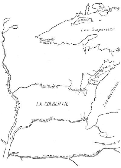
WESTERN PORTION OF JOLIET’S LARGER MAP (1674).
A reduced sketch of the copy in the Barlow Collection. The river marked “Route du Sieur de la Salle” is seemingly drawn in by a later hand, and the stream is without the coloring given to the other rivers. In its course, too, it runs athwart the vignette surrounding the scale at the bottom of the map, as if added after that was made. It is Harrisse’s no. 203.
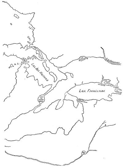
EASTERN PORTION OF JOLIET’S LARGER MAP (1674).
Mention may be made in passing of a small map within an ornamented border, and detailing the results of these explorations, which bears a Dutch title in the vignette, and another along the bottom in French, as follows: Pays et peuple decouverts en 1673 dans la partie septentrionale de l’Amerique par P. Marquette et Joliet, suivant la description qu’ils en ont faite, rectifiée sur diverses observations posterieures de nouveau mis en jour par Pierre Vander Aa à Leide.
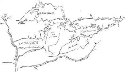
JOLIET’S SMALLER MAP.
This is Harrisse’s no. 204. The original is in the Archives of the Marine at Paris; cf. Library of Parliament Catalogue, 1858, p. 1615; Parkman’s La Salle, p. 453.
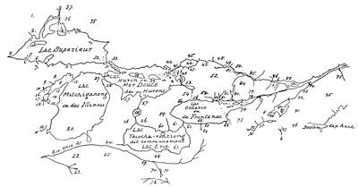
BASIN OF THE GREAT LAKES.
A reduced sketch of no. 3 of the Parkman maps, which measures 30 × 44 inches. It is without title or maker’s name, and the figures stand for the names and legends as given below:
1. Pays des Outaouacs qui habitent dans les forets.
2. Par cette riviere on va aus assinepoüalac a 150 lieues vers le Noreouest ou il y a beaucoup de Castor.
3. Isle Minong ou l’on croyoit que fust la mine de Cuivre.
4. Par cette riviere on va pays des nadouessien a 60 lieues au couchant. Ils ont 15 villages et sont fort belligueux et la terreur de ces contrées.
5. Pointe du St. Esprit.
6. R. Nantounagan.
7. Autrefois les restes de la Nation Huronne sestoient refugiez icy et les Jesuites y avoient une mission. Maintenant les Nadouessien ostants aus Hurons la liberté de chasser aus castors, ses sauvages ont quitté et les Jesuites les ont suivie.
8. Toutes ses nations qui se sont retirées en ces pays par terreur des Iroquois ont une tres grande quantité de Castors.
9. Nation et riviere des Oumalouminec, ou de la folle auoine.
10. Outagamis.
11. R. Mataban.
12. Isles ou les Hurons se refugierent apres la destruction de leur nation par les Iroquois.
13. Les pp. Jesuites ont icy une mission.
14. Kakaling rapide de trois lieues de longuerer.
15. Kitchigamenqué, ou lac St. Francois.
16. Pouteatamis.
17. Oumanis.
18. Maskoutens ou Nation du feu.
19. Riviere de la Divine.
20. Les plus grands navires peuvent venir de la decharge du lac Erie dans le lac frontenac jusques icy et de ce marais ou ils peuvent entrer il n y a que mille pas de distance jusqu’a la riviere de la Divine qui les peut porter jusqu’a la riviere Colbert et de la golfe de Mexique.
21. Riviere Ohio ainsy apellée par les Iroquois a cause de sa beauté par ou le Sr. de la Salle est descendu.
22. Les Illinois.
23. Raye des Kentayentoga.
24. Les Chaoüenons.
25. Cette riviere baigne un fort beau pays ou l’on trouvé des pommes, des grenades, des raisins et d’autres fruits sauvages. Le Pays est decouvert pour la plus part, y ayant seulement des bois d’espace en espace. Les Iroquois ont détruit la plus grande partie des habitans dont on voit encore quelques restes.
26. Tout ce pays est celuy qui est aus Environs du lac Teiochariontiong est decouvert. L’hiver y est moderé et court; les fruits y viennent en abondance; les bœufs sauvages, poules dinde et toute sorte de gibier s’y trouvent en quantité et il y a encore force castor.
27. Baye de Sikonam.
28. Les Tionontateronons.
29. Detroit de Missilimakinac.
30. Missilimakinac mission des Jesuites. Detroit par ou le lac des Illinois communique avec celuy des Hurons, par ou passent les sauvages du midy quand ils vont au Montreal chargez de Castors.
31. Sault de Ste. Marie. Ce sault est un Canal de demie lieue de largeur par lequel le lac Superieur se decharge dans le lac Huron.
32. Dans ce lac on trouve plusieurs morceaux de cuivre rouge de rozette tres pure. Outakouaminan.
33. Sauteurs. Sauvages qui habitent aus environs du Sault Ste. Marie.
34. Bagonache.
35. Gens des Torres. Toutes ces nations vivent de chasse dans les bois sans villages, et la plus part sans cultivee la terre, se trouvans seulement a de certains rendezvous de festes et de foire de temps en temps.
36. Kilistinons.
37. Les Alemepigon.
38. Ekaentoton Isle.
39. Lieu de l’assemblée de tous les sauvages allans en traitte a Montreal.
40. Les Kreiss.
41. Cette riviere vient du lac Nipissing. R. des Francois.
42. Les Amicoue.
43. Les Missisaghé.
44. Lac Skekoven ou Nipissing.
45. Sorciers.
46. A cet endroit il y a plusieurs petits marais par ou l’on va dans le lac Nipissing en portant plusieurs fois les canots.
47. Nipissiens.
48. Sault au talc Mataouan.
49. Sault au lieure. Sault aux Allumettes. Isle du Borgne.
50. Sault des Calumets.
51. Riviere des Outaouacs ou des Hurons.
52. Les Sauvages Loups et Iroquois tirent d’icy la plus grande partie du Castor qu’ils portent aus Anglois et aus Hollandois.
53. Cette rivière sort du lac Taronto et se jette dans le lac Huron.
54. Chemin par ou les Iroquois vont aus Outaoüacs, qu’ils auroient mené trafiquer a la Nouvelle Hollande si le fort de Frontenac n’eust ésté basti sur leur route.
55, 56. Villages des Iroquois dont quantité s’habituent de ce côté depuis peu. Teyoyagon, Ganatchekiagon, Ganevaské, Kentsio.
57. Canal par ou le lac des Hurons se decharge dans le lac Erie.
58. Tsiketo ou lac de la Chaudiere.
59. Atiragenrega, nation detruite.
60. Antouaronons, nation detruite.
61. Niagagarega, nation detruite. Chute haute de 120 toises par ou le lac Erie tombe dans le lac Frontenac.
62. Les Iroquois font leurs pesches dans tous les marais ou etangs qui bordent ce lac, d’ou ils tirent leur principale subsistance.
63. Ka Kouagoga, nation detruite.
64. Negateca fontaine.
65. Tsonontouaeronons.
66. Goyogouenronons.
67. Les environs de ce lac et l’extremité occidentale du lac Frontenac sont infestes de gantastogeronons, ce qui en eloigne les Iroquois.
68. Ce lac n’est pas le lac Erie, comme on le nomme ordinnairement. Erie est une partie de la Baye de Chesapeack dans la Virginie, ou les Eriechronons ont toujours demeuré.
69. Riviere Ohio, ainsy dite a cause de sa beauté.
70. Lac Onia-sont.
71. Les Oniasont-Keronons.
72. Riviere qui se rend dans la baye de Chesapeack.
73. Cahihonoüaghé, lieu on la plus part des Iroquois et des Loups debarquent pour aller en traitte du Castor a la Nouvelle York par les chemins marques de double rangs de points.
74. Les plus grands bastimens peuvent naviguer d’icy jusque au bout du lac Frontenac.
75. Korlar.
76. Albanie, ci-devant Fort d’Orange.
77. Riviere du nord, ou des traittes ou Maurice.
78. Otondiata.
79. Tout ce qui est depuis la Nouvelle Hollande jusques icy et le long du fleuve St. Laurent est convert de bois. La terre y est bonne pour la plus part et produit de fort beau blé.
80. Riviere Onondkouy.
81. Lac Tontiarenhé.
82. Ohaté.
83. Lac et riviere de Tanouate Kenté.
84. En cet endroit la grande riviere se précipite dans un puis dont on ne voit pas sortir.
85. Sault des chats.
86. Petite nation.
87. Long sault.
88. R. et I. Jesus, Montreal, etc.
89. Lac Champlain.
90. Lac du St. Sacrement.
91. Montagnes ou l’on trouve des veines de plomb, mais peu abondante.
92. St. Jean rapide.
93. Riviere de Richelieu.
94. Sorel.
95. Sauvages apelles Mahingans, ou Socoquis.
96. Socoquois, Goutsagans, Loups.
97. Vershe Riviere [Connecticut].
Dr. Shea places this map after La Salle’s descent of the Mississippi, “as the Ohio at its mouth was not recognized at that time as the Ohio of the Iroquois.” See Margry, ii. 191.
Something now needs to be said regarding Marquette’s contribution to our knowledge of this expedition of 1673. He seems to have prepared from memory a narrative for Frontenac, which is printed in two different forms in Margry.[572] Dablon used this account in his Relation, and sent a copy of the manuscript to Paris;[573] but he seems also to have prepared another copy, which was, with the original map, confided finally to the Archives of the Collége Ste. Marie at Montreal, where Shea found it, and translated it for his Discovery of the Mississippi,[574] in 1853, giving with it a fac-simile of the map.[575]
Mr. Neill, in comparing this map with the earliest of Joliet’s, as reproduced by Gravier says: “Joliet marks the large island toward the extremity of Lake Superior known as Isle Royale; but he gives no name, and he indicates four other islands on the north shore.”
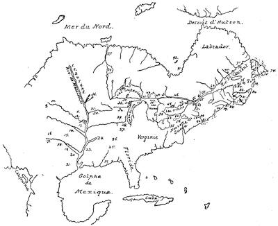
JOLIET’S CARTE GÉNÉRALE.
“This is a sketch reduced from the Parkman copy of the map, which measures 36 × 30 inches, and is called Carte genlle de la France septle contenant la descouverte du Pays des Illinois, faite par le Sr Jolliet; and is dedicated “A Monseigneur, Monseigneur Colbert, Conseiller du Roy en son Conseil Royal, Ministre et Sécrétaire d’Estat, Commandeur et Grand Trésorier des Ordes de sa Majesté, par son tres humble, tres obeisst, et tres fidelle serviteur, Duchesnau, Intendant de la Nouvelle France.” The figures stand for the following names and legends: 1. Alimouspigoiak. 2. Oussiloua. 3. Agatomitou. 4. Chaiena. 5. Ouapikouti. 6. Napapatou. 7. Pintoüa. 8. Ihanctoua. 9. Paoutek. 10. Maha. 11. Oloutanta. 12. Moengouena. 13. Ouatoutatoüaoü. 14. Grand Village. 15. Tanikoüa. 16. Acahichi. 17. Minouk. 18. Emmamoüata. 19. Akoraa. 20. Ototehiahi. 21. Tahenfa. 22. Europeans [sic]. 23. Mine de fer, Sable doré, Terre rouge ou siselée, Gouza. 24. R. Ouaboustikou. 25. Mataholi et Apistanga, 18 villages. 26. Chaoüanone, 15 villages. 27. Chaboüafioüa. 28. Mine de cuivre rouge. 29. Ilinois. 30. Riviere Miskous. 31. Mine de fer. 32. Maskoutens. 33. Outagami. 34. Puans. 35. Chaoüamigon. 36. Siou. 37. Assinibouels. 38. Lac des Assinibouels. 39. Minonk I. 40. Miscillimakinac. 41. Saut. 42. Missaské. 43. Amikoue. 44. Nipissink. 45. Mataouan. 46. Riviere des Outaouacks. 47. Kinté. 48. Ganateliftiagon. 49. Ganerafké. 50. I. Caiu-toton. 51. Fort Frontenac. 52. Teiaiagon. 53. Saût. 54. Sonontouans. 55. Oioguens. 56. Noutahe. 57. Onéoioutes. 58. Agnez. 59. Orange. 60. Hope. 61. Manate. 62. Lac St. Sacrémt. 63. Lac Champlain. 64. Ste. Terese. 65. Sorel. 66. Montreal. 67. Trois Rivieres. 68. Quebec. 69. Tadoussac. 70. R. St. Jean. 71. Ketsicagouesse. 72. Baye des Espagnols. 73. Terre Neuve. 74. Cape de Raze. 75. Plaisance. 76. I. la Magdelaine. 77. I. Brion. 78. I. aux oiseaux. 79. Cap Breton. 80. Canceaux. 81. Acadie. 82. Port Royal. 83. Baye des Chaleurs. 84. I. Bonventure. 85. I. Percée. 86. R. St. Jean. 87. R. Ste. Croix. 88. R. Etchemins. 89. R. Pintagouete. 90. Baston. 91. Miskoutenagach. 92. Ouabakounagon.
Marquette shows the large island only, but without a name. Joliet on the north shore of Lake Huron has three large islands,—one marked Kaintoton; Marquette has the same number, but without names. Parallel columns will show some other names of the two maps; the last three of each column referring to tribes between Green Bay and the Mississippi:—
Joliet’s Map. Marquette’s Map.
1. Lac Superieur. 2. Lac des Illinois, ou Missihiganin. 3. Baye des Puans. 4. Puans. 5. Outagami. 6. Maskoutens.
07. Lac Superieur, ov De Tracy. 08. Lac des Illinois. 09. No name. 10. Pouteoutami. 11. Outagami. 12. Maskoutens.
Joliet gives the name Miskonsing to the river, and marks the portage; while Marquette gives no names. The country south of Lake Superior and west of Lake Michigan in Marquette is blank. In Joliet it is marked ‘La Frontenacie.’ West of Lake Superior in Marquette is a blank; in Joliet are several lakes and the tribe of Madouesseou. Joliet calls the Mississippi, Rivière de Buade, and Marquette names it R. de la Conception.”
The original French of the narrative as Shea found it at Montreal was printed for Mr. Lenox in 1855,[576] and bears the following title: Récit des voyages et des découvertes du P. J. Marquette en l’année 1673, et aux suivantes;[577] and the copy being defective in two leaves, this matter was supplied from the print of Thevenot, next to be mentioned.
The copy which Dablon sent to Paris was used by Thevenot, who gives it, with some curtailment, in his Recueil de voyages, published in Paris in 1681,[578] with the caption: “Voyage et découverte de quelques pays et nations de l’Amérique septentrionale par le P. Marquette et Sr. Joliet.”[579]
The Jesuits about this time made a map, which, from having been given in Thevenot as Marquette’s, passed as the work of that missionary till Shea found the genuine one in Canada. What was apparently the original of this in Thevenot is a manuscript which Harrisse[580] says was formerly in the Bibliothèque Nationale at Paris, but cannot now be found. Mr. Parkman has a copy of it, and calls it “so crude and careless, and based on information so inexact, that it is of little interest.”[581]
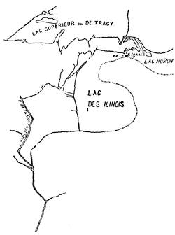
MARQUETTE’S GENUINE MAP.
As engraved in Thevenot, this map differs a little, and bears the title: “Carte de la découverte faite l’an 1673, dans l’Amérique septentrionale. Liebaux fecit.” Sparks followed this engraving in the map in his Life of Marquette, and calls it, with the knowledge then current, “the first that was ever published of the Mississippi River.”[582]
Marquette’s later history is but brief. In the autumn of the next year (1674) he started to found a mission among the Illinois; but being detained by illness near Chicago, he did not reach the Indian town of Kaskaskia till the spring of 1675. His strength was ebbing, and he started with his companions to return to St. Ignace, but had only reached a point on the easterly shore of Lake Michigan, when he died, and his companions buried him beside their temporary hut. The next year some Ottawas who had been of his flock unearthed the bones and carried them to Michillimackinac, where they were buried beneath the floor of the little mission chapel.[583]
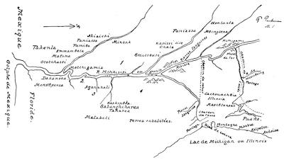
MISSISSIPPI VALLEY, 1672-1673.
This is a reduction of a manuscript map placed by Mr. Parkman in Harvard College Library, no. 5 of the series, entitled: Carte de la nouvelle decouverte que les péres Jesuites ont fait en l’année 1672, et continnuée par le P. Iacques Marquette de la mesme compagnie, accompagné de quelques françois en l’année 1673, qu’on pourra nommer en françois La Manitoumie a cause de la statue qui s’est trouvée dans une belle vallée, et que les sauvages vont reconnoistre pour leur divinitè, qu’ils appellent Manitou qui signifie esprit ou génie. A rude figure of this statue is placed on the map at 4, with this legend: “Manitou statue ou les sauvages font faire leurs adorations.” The other longer legends are: 1. “Nations qui ont des chevaux et des chameaux.” 2. “On est venu jusques icy a la hauteur de 33 deg.” 3. “Monsoupena, ils ont des fusila.” It will be seen that the return route of Marquette and Joliet is incorrectly laid down. Parkman’s La Salle, p. 65.
Thirty years ago there were statements made by M. Noiseux, late vicar-general of Quebec, to the effect that Marquette was not the first priest to visit the Illinois; but the matter was set at rest by Dr. Shea.[584] A renewed interest came in 1873 with the bicentennial of the discovery. Dr. Shea delivered an address on the occasion of the celebration,[585] and he also made an Address on the same theme before the Missouri Historical Society, July 19, 1878.[586] At the Laval University in Quebec the anniversary was also observed on the 17th of June, 1873, when a discourse was delivered by the Abbé Verreau.[587]
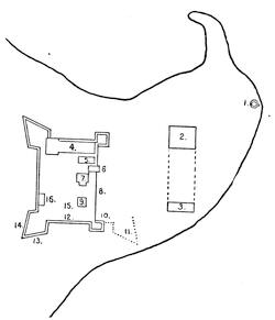
FORT FRONTENAC.
This sketch follows a plan sent by Denonville in 1685 to Paris, which is engraved in Faillon, Histoire de la Colonie Française, iii. 467. The key is as follows: 1. Four à chaux. 2. Grange. 3. Etable. 4. Logis. 5. Corps de garde. 6. Guerite sur la porte. 7. Boulangerie. 8. Palissade. 9. Moulin. 10. Mortier sans chaux. 11. Fondement bâti. 12. Haut de 4 pieds. 13. Haut de 12 pis. 14. A chaux et sable. 15. Puits. 16. Magasin à poudre. The peninsula extended into Lake Ontario. It is the fort as rebuilt of stone by La Salle. Cf. the paper on La Salle’s expenses on this fort, etc., in 2 Pennsylvania Archives, vi. 14, of which the original and other papers are given in Margry (i. 291).
New complications were now forming. The new governor, Frontenac, was needy in purse, expedient in devices, and on terms of confidence with a man destined to gain a name in this western discovery.[588] This was La Salle. Parkman pictures him with having a certain robust ambition to conquer the great valley for France and himself, and to outdo the Jesuits. Shea sees in him little of the hero, and few traces of a powerful purpose.[589] Whatever his character, he was soon embarked with Frontenac on a far-reaching scheme. It has been explained in the preceding chapter how the erection of a fort had been begun by Frontenac near the present town of Kingston on Lake Ontario. By means of such a post he hoped to intercept the trafficking of the Dutch and English, and turn an uninterrupted peltry trade to the French. The Jesuits at least neglected the scheme, but neither Frontenac nor La Salle cared much for them.[590] Fort Frontenac was the first stage in La Salle’s westward progress, and he was politic enough to espouse the Governor’s side in all things when disputes occasionally ran high. His becoming the proprietor of the seigniory, which included the new fort, meant the exclusion of others from the trade in furs, and such exclusion made enemies of the merchants. It meant also colonization and settlements; and that interfered with the labors of the Jesuits among the savages, and made them look to the great western valley, of which so much had been said; but La Salle was looking there too.[591]
In the first place he had strengthened his fort. He had pulled down the wooden structure, and built another of stones and palisades, of which a plan is preserved to us. He had drawn communities of French and natives about him, and maintained a mission, with which Louis Hennepin was connected. We have seen how in the autumn of 1677[592] he went once more to France, securing the right of seigniory over other posts as he might establish them south and west during the next five years. This was by a patent dated at St. Germain-en-Laye, May 12, 1678.[593] With dreams of Mexico and of a clime sunnier than that of Canada, La Salle returned to Quebec to make new leagues with the merchants, and to listen to Hennepin, who had come down from Fort Frontenac to meet him.[594] Mr. Neill (in the previous chapter) has followed his fortunes from this point, and we have seen him laying the keel of a vessel above the cataract.[595]
While this was going on La Salle returned below the Falls, and having begun two blockhouses on the site of the later Fort Niagara,[596] proceeded to Fort Frontenac. By spring Tonty had the “Griffin” ready for launching. She was of forty-five or fifty tons, and when she had her equipment on board, five cannon looked from her port-holes. The builders made all ready for a voyage in her, but grew weary in waiting for La Salle, who did not return till August, when he brought with him Membré the priest, whose Journal we are to depend on later, and the vessel departed on the voyage which Mr. Neill has sketched.[597]
After the “Griffin” had departed homeward from this region, La Salle and his canoes followed up the western shores of the lake, while Tonty and another party took the eastern. The two finally met at the Miamis, or St. Joseph River, near the southeastern corner of Lake Michigan.
They now together went up the St. Joseph, and crossing the portage[598] launched their canoes on the Kankakee, an upper tributary of the Illinois River, and passed on to the great town of the tribe of that name, where Marquette had been before them, near the present town of Utica.[599] They found the place deserted, for the people were on their winter hunt. They discovered, however, pits of corn, and got much-needed food. Passing on, a little distance below Peoria Lake they came upon some inhabited wigwams. Among these people La Salle learned how his enemies in Canada were inciting them to thwart his progress; and there were those under this incitement who pictured so vividly the terrors of the southern regions, that several of La Salle’s men deserted.
In January (1680) La Salle began a fortified camp near at hand, and called it Fort Crèvecœur,[600] and soon after he was at work building another vessel of forty tons. He also sent off Michel Accau, or Accault, and Hennepin on the expedition, of which some account is given by Mr. Neill, and also by the Editor in a subsequent note. Leaving Tonty in command of the fort, La Salle, in March, started to return to Fort Frontenac, his object being to get equipments for his vessel; for he had by this time made up his mind that nothing more would be seen of the “Griffin” and her return lading of anchors and supplies. For sixty-five days he coursed a wild country and braved floods. He made, however, the passage of a thousand miles in safety to Fort Frontenac, only to become aware of the disastrous state of his affairs,—the loss of supplies.[601] A little later the same sort of news followed him from Tonty, whose men had mutinied and scattered. His first thought was to succor Tonty and the faithful few who remained with him; and accordingly he started again for the Illinois country, which he found desolate and terrible with the devastations of the Iroquois. He passed the ruins of Crèvecœur, and went even to the mouth of the Illinois; and under these distressing circumstances he saw the Mississippi for the first time. Then he retraced his way, and was once again at Fort Miami. Not a sign had been seen of Tonty, who had escaped from the feud of the Iroquois and Illinois, not knowing which side to trust, and had made his way down the western side of Lake Michigan toward Green Bay.
La Salle meanwhile at Fort Miami was making new plans and resolutions. He had an idea of banding together under his leadership all the western tribes, and by this means to keep the Iroquois in check while he perfected his explorations southward. So in the spring (1681) he returned to the Illinois country to try to form the league; and while there first heard from some wandering Outagamies of the safe arrival of Tonty at Green Bay, and of the passage through that region of Hennepin eastward. Among the Illinois and on the St. Joseph he was listened to, and everything promised well for his intended league. In May he went to Michillimackinac, where he found Tonty and Membré, and with them he proceeded to Fort Frontenac. Here once more his address got him new supplies, and in the autumn (1681) he was again on his westward way. In the latter part of December, with a company of fifty-four souls,—French and savage, including some squaws,—he crossed the Chicago portage; and sledding and floating down the Illinois, on the 6th of February he and his companions glided out upon the Mississippi among cakes of swimming ice. On they went.[602] Stopping at one of the Chickasaw bluffs, they built a small stockade and called it after Prudhomme, who was left in charge of it. Again they stopped for a conference of three days with a band of Indians near the mouth of the Arkansas, where, on the 14th of March, in due form, La Salle took possession of the neighboring country in the name of his King.[603] On still they went, stopping at various villages and towns, securing a welcome by the peace-pipe, and erecting crosses bearing the arms of France in the open squares of the Indian settlements. On the 6th of April La Salle divided his party into three, and each took one of the three arms which led to the Gulf. On the 9th they reunited, and erecting a column just within one of the mouths of the river, La Salle formally took possession of the great Mississippi basin in the name of the French monarch, whom he commemorated in applying the name of Louisiana to the valley.[604]
Up the stream their canoes were now turned. On reaching Fort Prudhomme La Salle was prostrated with a fever. Here he stayed, nursed by Membré,[605] while Tonty went on to carry the news of their success to Michillimackinac, whence to despatch messengers to the lower settlements. At St. Ignace La Salle joined his lieutenant.
For the events of these two years we have two main sources of information. First, the “Relation de la descouverte de l’embouchure de la Rivière Mississipi dans le Golfe de Mexique, faite par le Sieur de la Salle, l’année passée, 1682,” which was first published by Thomassy;[606] the original is preserved in the Archives Scientifiques de la Marine, and though written in the third person it is held to constitute La Salle’s Official Report, though perhaps written for him by Membré.[607] Second, the narrative ascribed to Membré which is printed in Le Clercq’s Établissement de la Foi, ii. 214, and which seems to be based on the document already named.[608]
In addition to this there is the paper of Nicolas de la Salle (no kinsman of the explorer), who wrote for Iberville’s guidance, in 1699, his Récit de la découverte que M. de la Salle a faite de la Rivière de Mississipi en 1682.[609]
La Salle’s future plans were now clearly fixed in his own mind, which were to reach from Europe the Mississippi by sea, and to make it the avenue of approach to the destined colonies, which he now sent Tonty to establish on the Illinois. With as little delay as possible, he went himself to join his deputy. In December they selected the level summit of the scarped rock (Starved Rock), on the river near the great Illinois town, and there intrenched themselves, calling their fort “St. Louis.” Around it were the villages and lodges of near twenty thousand savages, including, it is estimated, about four thousand warriors. To this projected colony La Salle was under the necessity of trying to bring his supplies from Canada till the route by the Gulf could be secured,—that Canada in which he had many enemies, and whose new governor, De la Barre, was hostile to him, writing letters of disparagement respecting him to the Court in Paris,[610] and seizing his seigniory at Fort Frontenac on shallow pretexts. Thwarted in all efforts for succor from below, La Salle left Tonty in charge of the new fort,[611] and started for Quebec, meeting on the way an officer sent to supersede him in command. From Quebec La Salle sailed for France.[612]
At this time the young French engineer, Franquelin, was in Quebec making record as best he could, from such information as reached headquarters, of the progress of the various discoverers. There are maps of his as early as 1679 and 1681 which are enumerated by Harrisse.[613] Parkman is also inclined to ascribe to Franquelin a map with neither date nor author, but of superior skill in drafting, which is called Carte de l’Amérique septentrionale et partie de la meridionale ... avec les nouvelles decouvertes de la Rivière Mississipi, ou Colbert. It records an event of 1679 in a legend, and omits the lower Mississippi; which would indicate that the record was made before the results of La Salle’s explorations were known.[614] A sketch of the Map of 1682 is given herewith from a copy in the Barlow Collection.
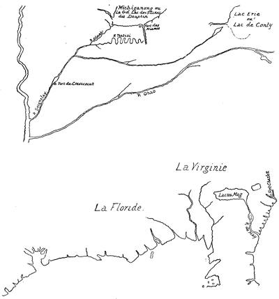
MAP OF 1682.
From La Salle, on his arrival in Quebec late in 1683, Franquelin undoubtedly got new and trustworthy information of that explorer’s expedition down the Mississippi; and this he embodied in what is usually known as Franquelin’s Great Map of 1684. It professed to have been made in Paris, and as Franquelin was not in that city in 1684, Harrisse contends that it was the work of De la Croix upon Franquelin’s material. It is called Carte de la Louisiane, ou des voyages du Sieur de la Salle et des pays qu’il a découverts depuis la Nouvelle-France jusqu’au Golfe de Mexique, les années 1679-80-81 et 82, par Jean-Baptiste Louis Franquelin, l’an 1684, Paris. It was formerly in the Archives du Dépôt de la Marine; but Harrisse[615] reports it as missing from that repository, and describes it from the accounts given by Parkman and by Thomassy.[616] A manuscript copy of this map was made for Mr. Parkman, which is now in Harvard College Library, and from this copy another copy was made in 1856, which is now in the Library of Parliament at Ottawa. Mr. Parkman’s copy has been used in the annexed sketch.
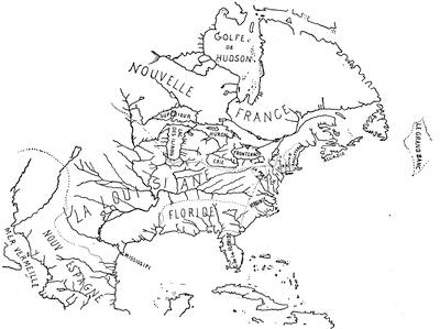
FRANQUELIN’S 1684 MAP.
Harrisse says that De la Croix made the Carte de l’Amérique septentle,[617] which also purports to be Franquelin’s, and shows the observations of “douze années.” Harrisse places this map also in 1684, for the reason that a third map by Franquelin, Carte de la Amérique septentrionale,[618] is dated 1688, and claims to embody the observations of “plus de 16 années,” giving names and legends not in the earlier ones.[619]
“It indicates,” says Mr. Neill, “the post which had been recently established by Du Lhut near the lower extremity of Lake Huron, and gives the present name, Manitoulin, to the large island of Lake Huron, and marks on the west shore a Baye de Saginnam. It places the mission on the south shore of Sault Ste. Marie, and names the rivers and points on the north and south shores of Lake Superior. A stream near the present northern boundary-line of the United States is called ‘R. des Grossillers,’ after the first explorer of Minnesota. The river entering Lake Superior at the present Fort William is ‘Kamanistigouian, ou Les Trois Rivières.’ Isle Royale is called ‘Minong;’ upon the northeast part of ‘Lac Alepimigon’ is Du Lhut’s post, ‘Fort La Tourette.’ At the portage between the sources of the St. Croix and a stream entering Lake Superior is ‘Fort St. Croix,’ which Bellin says was afterward abandoned. The St. Croix River is called ‘R. de la Magdelaine.’ At the lower extremity of Lake Pepin is ‘Fort St. Antoine;’ and the site of the present town of Prairie du Chien, near the mouth of the Wisconsin, appears as ‘Fort St. Nicolas,’ named in compliment to the baptismal name of Perrot. The Minnesota River is marked ‘Les Mascoutens Nadouescioux,’ indicating that it ran through the country of the Prairie Sioux. After Pierre Le Sueur had explored this river, De l’Isle, in his map of 1703, gives it the name of St. Pierre, as it is supposed in compliment to Le Sueur.”
A map of the next year (1689), also in the Archives, claims to be based on “Mémoires et relations qu’il a eu soin de recueillir pendant pres de 17 années.” Harrisse thinks this also a copy by De la Croix, and notes others of the probable dates of 1692 and 1699 respectively.[620] Harrisse also records[621] a manuscript map, “composée, corrigée, et augmentée sur les journaux, mémoires, et observations les plus justes qui en ont été ftes. en l’année 1685 et 1686,” which is also preserved in the French Archives; and a Carte Gēralle du voyage que Monsr De Meulles ... a fait; ... commencé le 9e Novembre et finy le 6e Juillet, 1686,[622] which was dedicated to Seignelay in the same year.
Parkman[623] says of the maps of Franquelin subsequent to his Great Map of 1684, that they all have more or less of its features, but that the 1684 map surpasses them all in interest and completeness.
It is convenient to complete here this enumeration of the maps of the western lakes and the Mississippi basin before we turn to La Salle’s explorations from the Gulf side.
One of the earliest of the printed maps is that called Partie occidentale du Canada, ou de la Nouvelle France, ou sont les nations des Ilinois, de Tracy, les Iroquois, et plusieurs autres peuples, avec la Louisiane nouvellement découverte, ... par le P. Coronelli, corrigée et augmentée par le Sr. Tillemon à Paris, 1688, of which the annexed sketch follows a copy in Harvard College Library. This was united with the Partie orientale in 1689 in a single smaller map.[624]
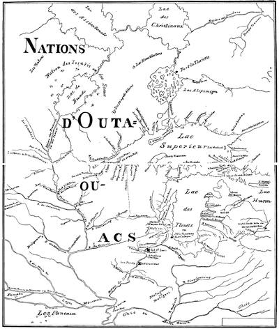
FRANQUELIN’S 1688 MAP.
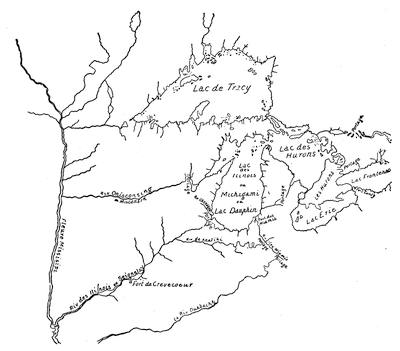
CORONELLI ET TILLEMON, 1688.
The routes of several of the early explorers, like those of Du Lhut, Joliet, and Marquette (1672), and La Salle (1679-1680), are laid down on a manuscript map, Carte des parties les plus occidentales du Canada, par le Père Pierre Raffeix, S. J.,[625] which is preserved in the Bibliothèque Nationale, and of which a sketch as “Raffeix, 1688,” is given on the next page.
A map of Lakes Ontario and Erie, by the Père Raffeix, is in the Bibliothèque Nationale in Paris;[626] and from a copy in the Kohl Collection at Washington the sketch on page 234 is taken. It is called, Le Lac Ontario avec les lieux circonvoisins et particulierment les cinq Nations Iroquoises.
Another map, thought to be the work of Raudin, Frontenac’s engineer,[627] should be found in the Archives of the Marine, but according to Harrisse it is not there.[628] The Barlow Collection, however, has a map which Harrisse believes to be the lost original; a sketch of the western part is given herewith.[629] It also gives the eastern seaboard with approximate accuracy, but represents Lake Champlain as lying along the headwaters of the Connecticut and the Hudson. Lake Erie is a squarish oblong, larger than Ontario, and of a shape rarely found in these early maps. In the upper lakes it resembles the map of 1672-1673, which Harrisse[630] also found missing from the Bibliothèque Nationale.
The maps which pertain to Hennepin and Lahontan are separately treated on a later page.
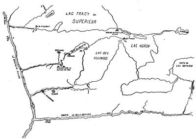
RAFFEIX, 1688.
This sketch is from a copy in the Kohl Washington Collection. There is another copy in the Barlow Collection. The original is in the Bibliothèque Nationale in Paris. (Harrisse, Notes, etc., no. 238.) It is marked, Parties les plus occidentales du Canada, Pierre Raffeix, Jesuite. Harrisse puts it under 1688; Kohl says between 1681 and 1688. The lines of exploration, as indicated on it, are explained in the marginal inscriptions as follows:—
Voyage et premiere descouverte de la riviere de Mississipi faite par le P. Marquette, Jesuitte, et Mr. Jolliet, en 1672.
(—.—.) signifie l’allée.
(.....), le retour.
Ils furent jusques pres du 32 degré d’elevation. (.——.) Mr. du Lude, qui le premier a esté ches les Sious ou Nadouesiou en 1678, et qui a esté proche la source du Mississipi, et qui ensuitte vint retirer le p. Louis [Hennepin], qui avoit esté fait prisonnier ches les Sious au P., et sen reviendre finir leur descouverte par ou le P. Marquette et Mr. Jolliet commencer la leur.
(..—..—) Voyage de Mr. de la Salle en 1679, qui ariva au fond du lac des Illinois et qui voula commencer un petit fort, et une barque a Crevecoeur, d’ou le Pere Louis [Hennepin] partit pour aller en haut a la descouverte. Mr. de la Salle escrit qu’en 1681 il descendit sur le Mississipi, et qu’il a esté jusqua la mer.
(E) Voyage a faire et plus facile pour descouvrir tout le Missĩpi en venant du lac Ontario au bourg des Senontonans et de la en E.
(F) 1. De l’Embouchure de cette petite riviere jusqu’aux Assinipouals et aleurs lacs Ilne a que 100 lieues.
2. Le pais des Assinipouals qui est le plus a l’ouest est un pais de continuelles prairies cõme tout le long du Missĩpi, et l’on y voit quelque fois passer dans un jour plus de 2 a 3,000 beufs sauvages. Il faut remarquer que osté la forme exacte de lacs que le peu de temps na pas permis de rechercher et que l’on trouve dans d’autres cartes; les rivieres y sont marques avec beaucoup de soin.
Pierre Raffæix, Jesuitte.
La Salle once in Paris (1684) succeeded in obtaining an interview with the King, to whom he then and subsequently in Memorials,[631] which have been saved to us, presented an ambitious scheme of fortifying the Mississippi near its mouths, and of subjugating the neighboring Spanish colonies, of whose propinquity he had very confused notions, as Franquelin’s map showed.
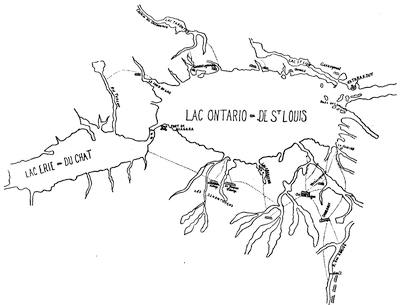
ONTARIO AND ERIE, BY RAFFEIX, 1688.
Peñalosa was at the same time pressing on the Court a plan for establishing a French colony at the mouth of the Rio Bravo. La Salle’s personal address, too, turned the scales against La Barre.

Accordingly, La Forest, the rejected commander of Fort Frontenac, was sent back to Canada with letters from the King commanding the Governor to make restitution to La Salle’s lieutenant both of Fort Frontenac and of Fort St. Louis. La Salle’s shining promises so affected Louis, that the King gave him more vessels than he asked for; and of these one, the “Joly,” carried thirty-six guns, and another six.[632] Among his company were his brother Cavelier and two other Sulpitian priests, and three Recollects, Membré, Douay, and Le Clercq.

A captain of the royal navy, Beaujeu, was detailed to navigate the “Joly,” but under the direction of La Salle, who was to be supreme. La Salle’s distrust and vacillation, and Beaujeu’s jealousy and assumptions boded no good, and a dozen warm quarrels between them were patched up before they got to sea.[633]
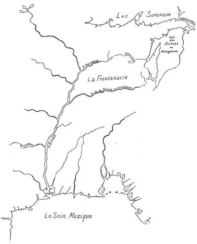
PART OF RAUDIN’S MAP.
Harrisse says: “This is the only map in which the name Bazire is given to the Arkansas River. Bazire was a merchant of Canada who in 1673 supported Frontenac in his design of building Fort Frontenac, with which Raudin had also a great deal to do.” This follows the Barlow original. There is in the Parkman Collection a copy of a part of it by Harrisse.
There was not a little in all this to point to a state of mental unsoundness in La Salle. At a late day Joutel, a fellow-townsman of La Salle, destined to become the expedition’s historian, joined the fleet at Rochelle, and on the 24th of July (1684) it sailed, only to put back, four days later, to repair a broken bowsprit of the “Joly.” Once again they put to sea.
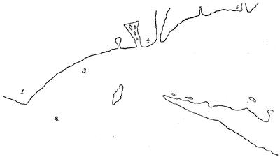
LA SALLE’S CAMP.
This is a reduced sketch from a copy in the Barlow collection of a Plan de l’entrée du lac ou l’on a laissé Monr de la Salle, which is preserved in the Archives of the Marine. It is Harrisse’s no. 226. The key is as follows: 1. Le camp de M. de la Salle. 2. Endroit ou la flutte c’est perdue. 3. La frigatte la “Belle” mouillée. 4 and 5. Cabannes des sauvages.
Everything still went wrong. The leaders chafed and quarrelled as on land.[634] The Spaniards captured their smallest vessel.[635] At Santo Domingo the Governor of the island and his officers joined in the quarrel on the side of La Salle, who now fell prostrate with disease. When he recovered he set sail again with his three remaining ships on the 25th of November, coasted the southern shore of Cuba, and on New Year’s Day (1685) sighted land somewhere near the River Sabine. He supposed himself east of the Mississippi mouths, when in fact he was far to the west of them. He knew their latitude, for he had taken the sun when there on his canoe voyage in 1682; but he had at that time no means of ascertaining their longitude. The “Joly” next disappeared in a fog, and La Salle waited for her four or five days, but in vain. So he sailed on farther till he found the coast trending southerly, when he turned, and shortly after met the “Joly.” Passages of crimination and recrimination between the leaders of course followed.[636] La Salle all the while was trying to make out that the numerous lagoons along the coast were somehow connected with the mouths of the Mississippi, while Beaujeu, vexed at the confusion and indecision of La Salle’s mind, did little to make matters clearer. They were in reality at Matagorda Bay. Trying to make an anchorage within, one of the vessels struck a reef and became a total wreck, and only a small part of her cargo was saved.[637] La Salle suspected it was done to embarrass him; and landing his men, he barricaded himself on the unhealthy ground, amid a confusion of camp equipage, including what was saved from the wreck. A swarm of squalid savages looked on, and saw a half-dozen of the Frenchmen buried daily. The Indians contrived to pilfer some blankets, and when a force was sent to punish them they killed several of the French. Beaujeu offered some good advice, but La Salle rejected it; and finally, on the 12th of March the “Joly” sailed, and La Salle was left with his forlorn colony.[638] Beaujeu steered, as he thought, for the Baye du St. Esprit (Mobile Bay [?]); but his belief that he was leaving the mouths of the Mississippi made him miss that harbor, and after various adventures he bore away for France, and reached Rochelle about the 1st of July. With him returned the engineer, Minet, who made on the voyage a map of the mouths of the Mississippi doubly interpreted,—one sketch being based on the Franquelin map of 1684, as La Salle had found it in 1682; and the other conformed to their recent observations about Matagorda, into whose lagoons he made this great river discharge.[639]
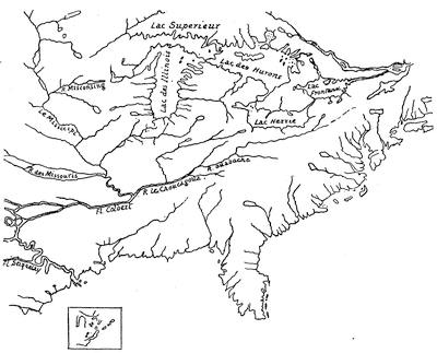
CARTE DE LA LOUISIANE, BY MINET, 1685.
This is a reduced sketch from a copy (Barlow Collection) of the original in the Archives of the Marine, giving two plans of the mouth of the river,—the one in the body of the map as “La Salle le marque dans sa carte,” and the other (here put in the small square), “Comme nous les avons trouvez.” It is Harrisse’s no. 225.
It soon dawned upon La Salle that he was not at the Mississippi delta; and it was imperative that he should establish a base for future movements. So he projected a settlement on the Lavaca River, which flowed into the head of the bay; and thither all went, and essayed the rough beginnings of a post, which he called Fort St. Louis.[640] He was also constrained to lay out a graveyard, which received its tenants rapidly. As soon as housing and stockades were finished, La Salle, on the last day of October (1685), leaving Joutel in command, started with fifty men to search for the Mississippi.
The first tidings Joutel got of his absent chief was in January (1686), when a straggler from La Salle’s party appeared, and told a woeful story of his mishaps. By the end of March La Salle himself returned with some of his companions; others he had left in a palisaded fort which he had built on a great river somewhere away. While on his return he detached some of his men to find his little frigate, the “Belle,” which he had left at a certain place on the coast. These men also soon appeared, but they brought no tidings of the vessel. The loss of her and of what she had on board made matters very desperate, and La Salle determined on another expedition, this time to the Illinois country and to Canada, whence he could send word to France for succor. On the 22d of April they started,—La Salle, his brother Cavelier, the Friar Douay, and a score or so others.
Joutel was still left in command; and a few days later the appearance of six men, who alone had been saved from the wreck of the “Belle,” and reached the fort, confirmed the worst fears of that vessel’s fate. Meanwhile La Salle was experiencing dangers and evils of all kinds,—the desertion and death of his men, and delays by sickness, and the spending of ammunition. Once again there was nothing for him to do but to return to Joutel, and so with eight out of his twenty men he came back to the fort. The colony had dwindled from one hundred and eighty to forty-five souls, and another attempt to secure succor was imperative. So in January (1687) a new cheerless party set out, Joutel this time accompanying La Salle; and with the rest were Duhaut, a sinister man, and Liotot the surgeon. For two months it was the same story of suffering on the march and of danger in the camp. Then quarrels ensued; and the murder of La Salle’s nephew and two others who were devoted to him compelled the assassins to save themselves by killing La Salle himself; and from an ambuscade Duhaut and Liotot shot their chief. The party now succumbed to the rule of Duhaut. They ranged aimlessly among the Indians for a while, and fell in with some deserters of La Salle’s former expedition now living among the savages. One of these conspired with Hiens, one of those privy to La Salle’s death, and killed the assassins Duhaut and Liotot. Joutel with the few who were left now parted amicably with Hiens and the savage Frenchmen, and pushed their way to find the Great River. At a point on the Arkansas not far from its confluence with the Mississippi, they were rejoiced to find the abode of two of Tonty’s men. This sturdy adherent of La Salle’s fortunes had been reinstated, as we have seen, by the King’s order, in the command of the fortified rock on the Illinois, and had in due time, after the return of Beaujeu to Rochelle, got the news of La Salle’s landing on the Gulf. In February, 1686, he had started down the river with a band of French and Indians to join his old commander. He reached the Gulf,[641] but of course failed to find La Salle; and returning, had left several men in the villages of the Arkansas, of whom Couture and another now welcomed Joutel and his weary companions. After some delay the wanderers floated their wooden canoe down the Arkansas, and then began their weary journey up the Great River, and by the middle of September they reached the Fort St. Louis of the Illinois. They found Tonty absent, and Bellefontaine in command. They foolishly thought to increase their welcome by presenting themselves as the forerunners of La Salle, who was on the way,—tidings which kept all in good spirits except the Jesuit Allouez, who happened to be in the fort, and was ill, for he was conscious of his machinations against La Salle, and dreaded to encounter him.[642] Cavelier and Joutel soon started for the Chicago portage. A storm on the lake impeded them subsequently, and they came back to the fort to find Tonty returned from Denonville’s campaign against the Senecas.[643] The same deceit regarding La Salle’s fate was practised on Tonty, and he gave them money and supplies as to La Salle’s representatives, only to learn a few months later, when Couture came up from the Arkansas, of La Salle’s murder. The wanderers, however, had now passed on, had reached Quebec in safety, still concealing what they knew, and not disclosing it till they reached France; and even in France there is a suspicion that Cavelier held his peace till he had secured some property against the seizure of La Salle’s creditors. Why Joutel connived at the deception is less comprehensible, for otherwise he bears a fair name. No representations of his, however, could induce the King to send succor to the hapless colony; and all the result, so far as known, of the tardy acknowledgment of La Salle’s death was an order sent to Canada for the arrest of his murderers.
The story which Couture told to Tonty in September inspired that hero with a determination to try to rescue La Salle’s colony on the Gulf. So in December he left his fortified rock, with five Frenchmen and three others. Late in March he was on the Red River, where all but two of his companions deserted him. He was himself finally, by the loss of his ammunition, compelled to turn back, but not till he had learned of the probable death of Heins.[644] In September he reached his fort on the Illinois; and here, with La Forest, he continued to live, holding the seigniory jointly under a royal patent, and trading in furs, till 1702, when the establishment was broken up.[645] Tonty now joined D’Iberville in Louisiana, and of his subsequent years nothing is known. The French again occupied his rocky fastness; but when Charlevoix saw it, in 1721, it was only a ruin.
The fate of the Texan colony is soon told. The Spaniards who had searched for it by sea had always missed it, though they had found the wrecked vessels.[646] A Frenchman, probably a deserter from La Salle, fell into the Spaniards’ hands in New Leon. From him they learned its position, and despatched under the Frenchman’s guidance a force to capture it. They found the fort deserted, and three dead bodies a little distance off. From the Indians they learned of two Frenchmen who were living with a distant tribe. They sent for them under a pledge of good treatment; and when they came, they proved to be L’Archevêque, one of Duhaut’s accomplices, and one of the stray deserters whom Joutel had discovered after the murder. They told a story of ravages from the small-pox and of slaughter by the savages. A few of the colonists had been saved by the Indian women; but these were subsequently given up to the Spaniards, and they added their testimony to the sad and ignominious end of the colony.
It is necessary to define the historical sources regarding this hapless Texan expedition, about the purpose of which there have been some diverse views lately expressed. It is clear that under cover of a grand plan of Spanish conquest, La Salle had dazed the imagination of the King in memorials,[647] which may possibly have been only meant to induce the royal espousal of his more personal schemes. Shea contends that La Salle’s real object was not to settle in Louisiana, but to conquer Santa Barbara and the mining regions in Mexico, and to pave the way for Peñalosa’s expedition.[648]
For the broader relations of the expedition to the earlier explorations of 1682, we must go to a source of the first importance preserved in the Archives of the Marine. It is entitled Mémoire envoyé en 1693 sur la découverte du Mississipi et des nations voisines par le Sieur de la Salle, en 1678, et depuis sa mort par le Sieur de Tonty, and is printed by Margry;[649] and Parkman calls it excellent authority. Out of this and an earlier paper, written in Quebec in 1684,[650] a book, disowned by Tonty, as Charlevoix tells us, was in part fabricated, and appeared at Paris in 1697 under the title of Dernières découvertes dans l’Amérique septentrionale de M. de la Salle, mises au jour par M. le Chevalier Tonti, gouverneur du Fort St. Louis, aux Islinois.[651] Parkman[652] calls it “a compilation full of errors,” and does not rely upon it. Shea says of it that, “although repudiated by Tonti, it must have been based on papers of his.” It has been held apocryphal by Iberville and Margry; but Falconer, La Harpe, Boimare, and Gravier put trust in it.
It is thought that a Journal by Joutel was written in part to counteract the statements of the Dernières découvertes. This Joutel paper was given first in full by Margry,[653] and Parkman[654] says of it that it seems to be “the work of an honest and intelligent man.”[655] It was printed in Paris in 1713, but abridged and changed in a way which Joutel complained of, and bore the title, Journal historique du dernier voyage que feu M. de la Salle fit dans le Golfe du Mexique, pour trouver l’embouchure du Mississipi. Par M. Joutel.[656]
To these there are various supplemental narratives, with their interest centring in the death of La Salle.[657] Joutel gives an account of the scene as he learned it at the time.[658] Tonty’s account was at second hand. Douay saw the deed, and what he reported is given in Le Clercq’s Établissement de la Foi.[659] A document in the Archives of the Marine—Relation de la mort du Sr. de la Salle, suivant le rapport d’un nommé Couture, à qui M. Cavelier l’apprit en passant au pays des Akansa—is given by Margry;[660] and Harrisse thinks that it merits little confidence.
Cavelier is known to have made a report to Seignelay; and his rough draft of this was recovered in 1854 by Parkman,[661] who calls it “confused and unsatisfactory in its statements, and all the latter part has been lost,” the fragment closing several weeks before the death of his brother.[662]
The character of Beaujeu has certainly been put in a more favorable light by the publication of Margry, and the old belief in his treachery has been somewhat modified.[663]
The Spanish account of the fate of the colony is translated from Barcia’s Ensayo cronologico de la Florida,[664] in Shea’s Discovery of the Mississippi;[665] and Margry[666] adds to our knowledge, as does Buckingham Smith in his Coleccion.[667]
It remains now to speak of the Collections which have been formed, and the theories regarding these Western explorations which have been maintained, by M. Pierre Margry, who has occupied till within a few years the office of archivist of the Marine and Colonies in Paris, having been for a long period assistant and principal. Margry may be said to have discovered what that department contained in manuscripts relating to the explorations of the Mississippi Valley and River, particularly as regards La Salle’s agency. On more than one occasion he has done good service in helping to enrich the archives of New York[668] and Canada with copies of documents known to him,—so far, apparently, as they did not interfere with his own projects of publication. His position created relations for him with other departments of the French Government, and his eager discernment found an abundance of manuscript treasures even in private hands. These he assiduously gathered, and on a few occasions he published papers[669] which seemed to indicate more than he chose to disclose explicitly; for his fellow-students were not quite satisfied, and longed for the documents which had yielded so much. As the guardian of the public archives, he was by office the agent and servant of the public; but other investigators, it is feared, failed, through obstacles thrown in their way, to profit as they might by what that office contained. There is in the Sparks Collection of Manuscripts in Harvard College Library a volume of copies of such documents as could be found in the Paris Archives which that historian intended to use in another edition of his Life of La Salle. While Mr. Sparks was regretting that not a single document or letter in the hand of the great explorer had come down to us, enough to fill a large volume was immured in these Paris Archives. At a later day Mr. Parkman, in turn, failed of access to documents which were of the first importance to him, and he was obliged to make the best use he could of what it was possible to obtain. Environed by these disadvantages Mr. Parkman published, in 1869, his Discovery of the Great West. In his Preface, speaking of the obscurity which had enshrouded the whole subject, he referred to the “indefatigable research of M. Pierre Margry, Assistant-Custodian of the Archives of the Marine and Colonies at Paris, whose labors as an investigator of the maritime and colonial history of France can be appreciated only by those who have seen their results.”
Gravier about the same time referred to the twenty years of study which had made M. Margry the most learned of students of La Salle’s history.
It was evident that investigators could not profit by this accumulation of material, unless M. Margry’s hopes of publication were realized. He refused offers to purchase. In conjunction with M. Harrisse, an effort was made by him in 1870-1871 to enlist the aid of the United States Congress; but a vote which passed the Senate failed in the House. The great fire at Boston in 1872 stayed the progress which, under Mr. Parkman’s instigation, had been made to insure a private publication. At last, by Mr. Parkman’s assiduous labors in the East, and by those of Colonel Whittlesey, Mr. O. H. Marshall, and others in the West, and with the active sympathy of the Hon. George F. Hoar, a bill was passed Congress in 1873, making a subscription for five hundred copies of the intended work.[670]
With this guaranty M. Margry put to press the series of volumes entitled Mémoires et documents pour servir à l’histoire des origines Françaises de pays d’outre-mer: découvertes et établissements des Français dans l’ouest et dans le sud d’Amérique septentrionale. The first volume appeared in 1876. It contained an Introduction by M. Margry, and was prefixed by a very questionable likeness of La Salle,—the picture (of which nothing was said by the editor) having no better foundation than the improbable figure of the explorer in a copperplate, published some years after his death, representing the scene of his murder, and of which a fac-simile is annexed.[671] Of the intended volumes, three are devoted to La Salle, and appeared between 1876 and 1878: vol. i., Voyages des Français sur les grands lacs, et découvertes de l’Ohio et du Mississippi, 1614-1684; vol. ii., Lettres de La Salle, et correspondance relative à ses entreprises, 1678-1685 (these include letters also preserved in the Bibliothèque Nationale); vol. iii., Recherche des bouches du Mississipi et voyage à travers le continent depuis les côtes du Texas jusqu’à Québec.
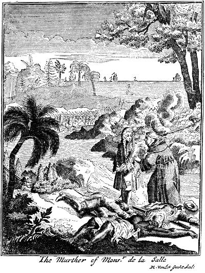
The later volumes (the Editor has seen in Mr. Parkman’s hands the proofs of vols. iv. and v., and there is to be one more) pertain to Iberville and the following century; but a volume of the early cartography is promised as a completion of the publication. On the issue of these three volumes Mr. Parkman in considerable part rewrote his Discovery of the Great West, and republished it in 1879 as La Salle and the Discovery of the Great West. In his Preface he speaks of the collection of documents in Margry’s keeping “to which he had not succeeded in gaining access,” and which, besides the papers in his official charge, included others added by him from other public archives and from private collections in France. “In the course of my inquiries,” says Mr. Parkman, “I owed much to [M. Margry’s] friendly aid; but his collections as a whole remained inaccessible, since he naturally wished to be the first to make known the results of his labors.”