Part 2 — CHAPTER I. (continued 2)
Reading edition
Belleforest and Fumée have also written in harsh terms about Thevet. De Thou, a historian of far more dignified and impartial character than these others, is nearly as abusive. He says: “Il s’appliqua par une ridicule vanité à écrire des livres, qu’il vendait à des misérables libraires: après avoir compilé des extraits de différents auteurs, il y ajoutait tout ce qu’il trouvait dans les guides des chemins et autres livres semblables qui sont entre les mains du peuple. Ignorant au-delà de ce qu’on peut imaginer, il mettait dans ses livres l’incertain pour le certain, et le faux pour le vrai, avec une assurance étonnante.”[125]
Even Thevet’s latest editor, M. Gaffarel, is forced to begin his notice of the monk by allowing that he was not “un de ces écrivans de premier ordre, qui, par la sûreté de leur critique, le charme de leur style, ou l’intérét de leurs écrits commandent l’admiration à leurs contemporains, et s’imposent à la postérité. Il passait, au contraire, même de son temps, pour ne pas avoir un jugement très sur,” etc. M. Gaffarel claims for Thevet the credit of introducing tobacco into France, and hopes that this may balance the imperfections of his books.
Dr. Kohl gave some credence to Thevet’s narrative, but admits that he is “not esteemed as a very reliable author.” Still, he translated the account of his visit to Penobscot Bay, and inserted it entire in his Discovery of Maine.[126] Dr. De Costa in 1870 criticised this view of Dr. Kohl.[127]

Note.—Harrisse, in his recent Discovery of North America (p. 234), cites for the first time a long passage about Gomez’s voyage from the Islario of Alonso de Santa Cruz, preserved in the Imperial Library at Vienna, and finds it to be the source whence Cespedes (see ante, p. 24) drew his language; and in it he finds somewhat uncertain proof that Gomez went as far north as the entrance of the Gulf of St. Lawrence, and corrected some cartographical notions respecting those waters. A map showing Gomez’s discoveries is attached to the Islario, and Harrisse gives this map in fac-simile.
MAPS OF THE EASTERN COAST OF NORTH AMERICA,
1500-1535,
WITH THE CARTOGRAPHICAL HISTORY OF THE SEA OF VERRAZANO.
BY THE EDITOR.
THE Editor has elsewhere[128] referred to the great uncertainty attending the identification of minor coast localities in the earliest maps. The most trustworthy interpreters recognize two important canons,—namely, that cartographical names during a long series of years, and at an era of exploration forerunning settlements, are always suspicious and often delusive, as Professor Bache has pointed out in the Coast Survey Report for 1855 (p. 10); and that direction is likely to be right, and distance easily wrong, as Humboldt has explained. Nothing is more seductive than to let a spirit of dogmatism direct in the interpretation of the early maps, and there is no field of research in which predisposition to belief may lead one so wrongly. It was largely in the spirit of finding what they sought, that the early map-makers fashioned their charts; and their interpretation depends quite as much on geographical views current in those days as upon geographical facts patent in these days.
The study of early American cartography may be said to have begun with Humboldt; and in this restricted field no one has since rendered greater service than Dr. Kohl.[129] Mr. Brevoort, not without justice, calls him “the most able comparative geographer of our day.”[130] The labor which Dr. Kohl performed took expression not only in his publications, but also in the collection of copies of early maps which he formed and annotated for the United States Government twenty-five years ago. His later printed books, using necessarily much of the same material, may be riper from longer experience; but the Washington Collection, as he formed it, is still valuable, and deserves to be better known. It belongs to the Department of State, and consists of not far from four hundred maps, following printed and manuscript originals. They are carefully and handsomely executed, but with little attempt at reproduction in fac-simile. By favor of the Secretary of State, and through the interest of Theodore F. Dwight, Esq., the librarian of that department, the collection has been intrusted to the Editor for use in the present work and for the preparation of an annotated calendar of the maps which will be printed by Harvard University.
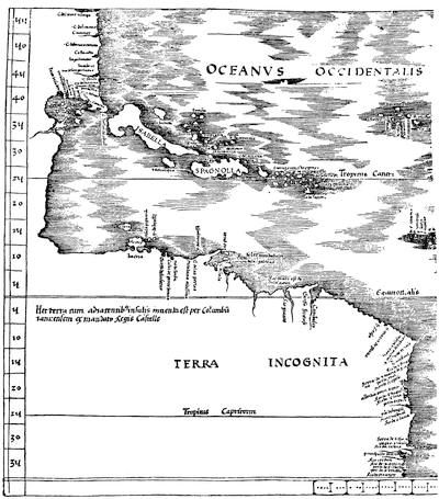
THE ADMIRAL’S MAP, 1513.
Besides this collection in the State Department (which cost the Government nearly $6,000), the Reports of the United States Coast-Survey[131] describe three other collections, accompanied by descriptive texts, which he made for that office, and which he proposed to call collectively “The Hydrographic Annals of the United States.” They repeat many of the maps belonging to the State Department Collection. These supplemental collections are,—
1. On the eastern coast of the United States, giving copies of 41 maps; the titles of 155 surveys of the coast between 1612 and 1851; a list of 291 works on the early explorations of the coast; and an historical memoir on such voyages, from the Northmen down.
2. On the coasts of the Gulf of Mexico falling within the United States, giving copies of 48 maps from 1500 to 1846; the titles of 58 surveys (exclusive of those of the United States), between 1733 and 1851; a list of 221 books and manuscripts on the explorations since 1524; and an historical memoir of the explorations between 1492 and 1722.[132]
3. On the west coast of the United States, giving a bibliography of 230 titles.
There is another historical memoir by Dr. Kohl, with other copies of the maps of the west coast, in the Library of the American Antiquarian Society at Worcester, Mass.; and this also has been in the temporary custody of the Editor.[133] At the time of his death Dr. Kohl was occupied with the preparation of a history of the Search for a Northwest Passage, from Cortes to Franklin, of which only a fragment appeared in the Augsburg periodical, Ausland. It was a theme which would naturally have embraced the whole extent of his knowledge of early American discovery and cartography.[134]
The best printed enumeration of maps of the eastern coast of North America is given by Harrisse for the earlier period in his Cabots, and for a later period in his Notes sur la Nouvelle France.
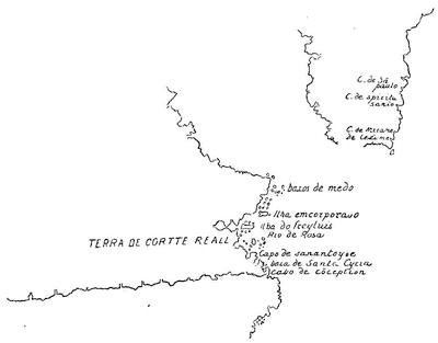
PORTUGUESE CHART, 1503 (after Kohl).
The map of La Cosa (1500) still remains the earliest of these delineations, and a heliotype of it is given in another volume.[135] Harrisse has lately claimed the discovery in Italy of a Portuguese chart of 1502, showing the coast from the Gulf of Mexico to about the region of the Hudson River, which bears coast names in twenty-two places; but the full publication of the facts has not yet been made;[136] and there is no present means of ascertaining what relation it bears to a large manuscript map of the world, of Portuguese origin, preserved in the Archives at Munich, of which a part is herewith sketched from Dr. Kohl’s copy, and to which he gives the conjectural date of 1503.
Dr. Kohl also reproduces it in part in his Discovery of Maine, p. 174, where he dates it 1504. His two copies vary, in that the engraved one seems to make the east and west coast-line from “Cabo de Conception” the determinate one, while his manuscript copy gives the completed character to the other line. It is held to record the results of Cortereal’s voyage, and shows in Greenland a more correct outline than any earlier chart. The other coast seems to be Labrador and Newfoundland run into one. Peschel (Geschichte des Zeitalters der Entdeckungen, p. 331) puts the date 1502 or 1503. The present Cape Freels, on the Newfoundland coast, is thought to be a corruption of “Frey Luis,”—here given to an island. (Cf. Kunstmann, Die Entdeckung Amerikas, pp. 69, 128.) Harrisse (Cabots, p. 161) speaks of Kunstmann’s referring it to “Salvat de Pilestrina,” and thinks that the author may be “Salvat[ore] de Palastrina” of Majorca. Lelewel also gives in his Géographie du Moyen-Âge (plate 43) a map of importance in this connection, which he dates 1501-1504, and which seems to be very like a combination of the two Ptolemy maps of 1513. The Reinel Chart of 1505 has been referred to in the preceding text.[137]
The Catalogue of the Library of Parliament (Canada), 1858, p. 1614, gives what purports to be a copy of a “Carte de l’embouchure du St. Laurent faite et dressée sur une écorce de bois de Vouleau, envoyée du Canada par Jehan Denys, 1508.” Shea also mentions it in his Charlevoix, i. 106, with a reference to Ramusio’s third volume. Mr. Ben: Perley Poore, in his Documents collected in France, in the Massachusetts Archives, says he searched for the original of this map at Honfleur without success. Harrisse, Cabots, p. 250, says no such map is to be found in the Paris Archives; and a tracing being supplied from Canada, he pronounces it “absolument apocryphe,” with a nomenclature of the last century. Bancroft (United States, edition of 1883, i. 14) still, however, acknowledges a map of Denys of this date.
The question of the duration of the belief in the Asiatic connection of North America naturally falls into connection with the volume[138] of this work devoted to the Spanish discoveries. We may refer briefly to a type of map represented by the Lenox globe[139] (1510-1512), the Stobnicza map[140] (1512), the so-called Da Vinci sketch[141] (1512-1515), the Sylvanus map in the Ptolemy of 1511, the Ptolemy of 1513, the Schöner, or Frankfort, globe of 1515,[142] the Schöner globe of 1520,[143] the Münster map of 1532,[144] and even so late a representation as the Honter mappamundi of 1542, reproduced in 1552 and 1560. This type represents a solitary island, or a strip of an unknown shore, sometimes joined with the island, lying in the North Atlantic. The name given to this land is Baccalaos, or Corterealis, or some equivalent form of those words, and their coasts represent the views which the voyages of the Cabots and Cortereals had established. West and southwest of this the ocean flowed uninterruptedly, till you came to the region of Florida and its northern extension. The Portuguese seem to have been the first to surmise a continental connection to this region, in a portolano which is variously dated from 1514 to 1520, and whose legends have been quoted in the preceding text.[145]
The Portuguese claim of explorations in this region by Alvarez Fagundes in 1521, or later, is open to question. If a map which is brought forward by C. A. de Bettencourt, in his Descobrimentos dos Portuguezes em terras do ultramar nos seculos xv e xvi, published at Lisbon in 1881-1882, represents the knowledge of a time anterior to Cartier, it implies an acquaintance with this region more exact than we have other evidence of. The annexed sketch of that map follows a colored fac-simile entitled, “Fac-simile de uma das cartas do atlas de Lazaro Luiz,” which is given by Bettencourt. The atlas in which it occurs was made in 1563, though the map is supposed to record the explorations of João Alvarez Fagundes, under an authority from King Manoel, which was given in 1521. Harrisse in his Cabots (p. 277) indicates the very doubtful character of this Portuguese claim.
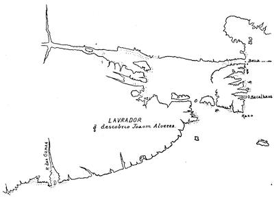
LAZARO LUIZ.
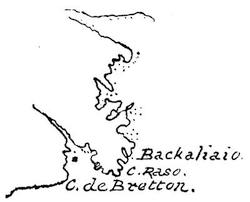
VERRAZANO, 1529.
The information concerning the Baccalaos region, which was the basis of these Portuguese charts, seems also to have been known, in part at least, a few years later to Hieronymus Verrazano, and Ribero, though the former contracted and the latter closed up the passages by the north and south of Newfoundland. The chart usually ascribed to Fernando Columbus[146] closely resembles that of Ribero. Of the Verrazano map sufficient has been said in the preceding text; but it may not be amiss to trace more fully the indications there given of its effect upon subsequent cartography, so far as it established a prototype for a great western sea only separated at one point from the Atlantic by a slender isthmus. Mr. Brevoort (Verrazano, p. 5) is of the opinion that the idea of the Western Sea originated with Oviedo’s Sumario of 1526.
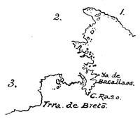
RIBERO, 1529.
The key is as follows:—
1. Esta tierra descubrierô los Ingleses, Tiera del Labrador.
2. Tiera de los Bacallaos, la qual descubrieron los corte reales.
3. Tiera de Esteva Gomez la qual descubrio por mandado de su. mag. el año de 1525, etc.
There are several early copies of this map. Harrisse describes the Weimar copy as having on “Tiera del Labrador” the words, “Esta tierra descubrieron los Ingleses no ay en ella cosa de pronecho.” Thomassy says the Propagande copy indicates the discovery of Labrador by the English of Bristol. See Vol. III. pp. 16, 24, and a note in chap. ix. of the present volume. The Ribero contour of the eastern coast long prevailed as a type. We find it in the Venice map of 1534, of which there is a fac-simile in Stevens’s Notes, and in the popular Bellero map of 1554 (in use for many years), and, with little modification, in so late a chart as Hood’s in 1592. It was held to for the coast between Florida and Nova Scotia long after better knowledge prevailed of the more northern regions. It was evidently the model of the map published by the Spanish Government in 1877 in the Cartas de Indias.
Reference has already been made to the map of Maggiollo, or Maiollo (1527), which Desimoni has brought forward, and of which a fac-simile of his sketch is reproduced on page 39. The sea will be here observed with the designation, “Mare Indicum.” Dr. De Costa showed a large photograph of it at a meeting of the New York Historical Society, May, 1883, pointing out that the name “Francesca” gave Verrazano the credit of first bestowing that name in some form upon what was afterward known as New France.[147]
In 1870 there was published in the Jahrbuch des Vereins für Erdkunde in Dresden (tabula vii.) a fac-simile of a map of America from a manuscript atlas preserved in Turin which gives conjecturally this western sea, closely after the type shown below in a map of Baptista Agnese (1536); its date is put somewhere between 1530 and 1540.
An Italian mappamundi of the middle of the sixteenth century is described by Peschel in the Jahresbericht des Vereins für Erdkunde in Leipzig, 1871, where the map is given in colored fac-simile. Peschel places it between 1534 and 1550; and it also bears a close resemblance to the Agnese map, as does also a manuscript map of about 1536, preserved in the Bodleian, of which Kohl, in his manuscript collection, has a copy. This Agnese map is a part of a portolano in the Royal Library at Dresden; and similar ones by him are said to be in the Royal Library at Munich, in the British Museum, and in the Bodleian, dated a few months apart. Kohl, in his Discovery of Maine (pl. xiv.), sketches it from the Dresden copy, and his sketch is followed in the accompanying cut. An account of Agnese’s cartographical labors is given in another volume.[148]
Perhaps the most popular map of America issued in the sixteenth century was Münster’s of 1540, of which a fac-simile is annexed. Kohl, in his Discovery of Maine (pl. xvª), erring, as has been pointed out by Murphy,[149] in giving a date (1530) ten years too early to this map, and in ignorance of the Maiollo map, was led into the mistake of considering it the earliest which has been found showing this western sea. The map was frequently repeated, with changes of names, during that century, and is found in use in books as late as 1572.[150]
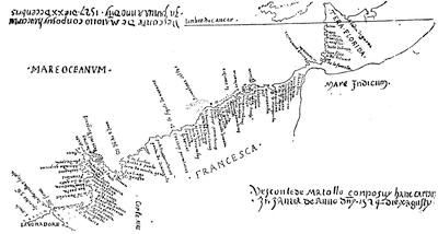
MAIOLLO, OR MAGGIOLO, 1527.
The two legends, with date, are explained on p. 28.
In the same year (1540) a similarly conjectural western sea was given in a map of the Portuguese Diego Homem, which is preserved in the British Museum. Kohl, in his Discovery of Maine (pl. xv.), gives this and other maps which support in his judgment the belief in the Verrazano Sea; but Murphy (Verrazzano, p. 106) denies that they contribute any evidence to that end. Of the Ulpius globe, mention has already been made.[151] A fac-simile of Dr. De Costa’s representation of the American portion is given herewith.
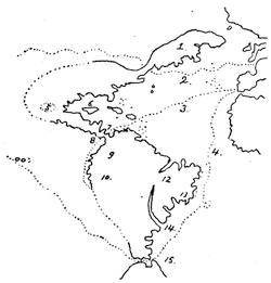
AGNESE MAP, 1536.
The key is as follows: 1. Terra de bacalaos. 2. (dotted line) El viage de france. 3. (dotted line) El viage de peru. 4. (dotted line) El viago a maluche. 5. Temistitan. 6. Iucatan. 7. Nombre de dios. 8. Panama. 9. La provintia de peru. 10. La provintia de chinagua. 11. S. paulo. 12. Mundus novus. 13. Brazil. 14. Rio de la plata. 15. El Streto de ferdinando de Magallanas.
Harrisse (Cabots, p. 191), referring to the dotted line of a route to India, which Agnese lays down on this map, crossing the Verrazano isthmus, thinks it is rather a reminiscence of Verrazano than of Cartier. Harrisse gives the legend, “el viazo de franza.”
There are two maps which connect this western sea, extending southerly from the north, with the idea that a belt of land surrounded the earth, there being a connection between Europe and Greenland, and between Greenland and Labrador, making America and Eastern Asia identical. This theory was represented in a map of 1544,—preserved in the British Museum and figured[152] by Kohl in his Discovery of Maine (pl. xv.), who assigns it to Ruscelli, the Italian geographer. Another support of the same theory is found in the “Carta Marina” of the 1548 edition of Ptolemy (map no. 60).
Jacobo Gastaldo, or Gastaldi, was the cartographer of this edition, and Lelewel[153] calls him “le coryphée des géographes de la peninsula italique.” Ruscelli, if he did not make this map for Gastaldo, included it in his own edition of Ptolemy in 1561, the maps of which have been pointed out by Thomassy as bearing “la plus grande analogie avec celles de la galerie géographique de Pie IV.,” while the same authority[154] refers to a planisphere of Ruscelli (1561) as “inédit, conservé au Musée de la Propagande.”[155]
This union of North America and Asia was a favorite theory of the Italians long after other nations had given it up.[156] Furlani in 1560 held to it in a map, and Ruscelli, in another map of the 1561 edition of Ptolemy, leaves the question unsettled by a “littus incognitum.”
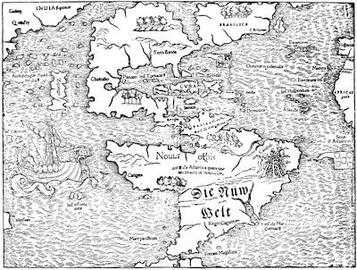
MÜNSTER, 1540.
Meanwhile Münster in the 1540 Ptolemy had given his idea of the western sea by making it a southern extension of the northwest passage. This is shown in a sketch of Münster’s 1540 map given above.
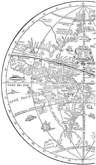
FROM THE ULPIUS GLOBE, 1542.
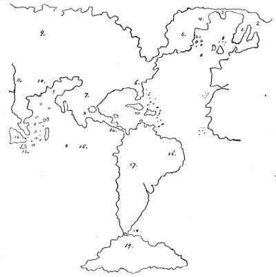
CARTA MARINA, 1548.
The key is as follows:— 1. Norvegia. 2. Laponia. 3. Gronlandia. 4. Tierra del Labrador. 5. Tierra del Bacalaos. 6. La Florida. 7. Nueva Hispania. 8. Mexico. 9. India Superior. 10. La China. 11. Ganges. 12. Samatra. 13. Java. 14. Panama. 15. Mar del Sur. 16. El Brasil. 17. El Peru. 18. Strecho de Fernande Magalhaes. 19. Tierra del Fuego
One of the most conspicuous instances of a belief in this sea was the Lok map of 1582, which Hakluyt published, as has been already stated, in his Divers Voyages of that year, which, being made “according to Verarzanus’s plot,” is reproduced here from the cut already given in the preceding volume.[157]
With Lok we may consider that the western sea vanishes, unless there be thought a curious relic of it in the map which John White, of the Roanoke Colony, made in 1585 of the coast from the Chesapeake to Florida, which is preserved among the De Bry drawings in the British Museum. The history of these drawings has been already told.[158] There is a copy of this map in the Kohl Collection; but the annexed sketch is taken from a fac-simile engraving given by Dr. Edward Eggleston in The Century Magazine, November, 1882. It will be observed that at Port Royal there seems to be a passage to western water of uncertain extent,[159] which was interpreted later as an inland lake.
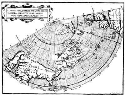
LOK’S MAP, 1582,—REDUCED.
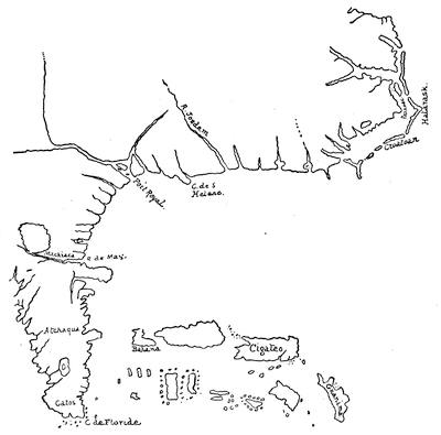
JOHN WHITE, 1585.
Other maps of this period have no trace of such western sea, like the protuberant “Terra del laboradore” of Bordone in 1521 and 1528;[160] the “Terra Francesca” of the Premontré globe, now in the National Library at Paris;[161] the northeasterly trend of the map of the monk Franciscus;[162] the “Nova Terra laboratorum dicta” of Robert Thorne’s map (1527);[163] Piero Coppo’s Portolano of 1528, in which America appears as a group of islands; and in the British Museum among the Sloane Manuscripts a treatise, De principiis astronomie, which has a map in which the eastern coast of America is made to consist of two huge peninsulas, one of them being marked “Terra Franciscana nuper lustrata,”[164] and the other, “Baccalear regio,” ending towards the east with a cape, “Rasu.”[165]
Kunstmann in his Atlas (pl. vi.) gives a map which he places between 1532 and 1540; it is of unknown authorship.
Wieser, in his Magalhâes-Strasse (p. 77), points to a globe of Schöner, the author of the Opusculum geographicum, in which he claimed that “Bachalaos—called from a new kind of fish there—had been discovered to be continuous with Upper India.”
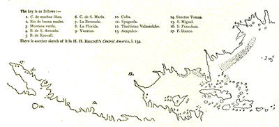
NORTH AMERICA, 1532-1540 (after Kunstmann).
There is a chart of Newfoundland and the Gulf of St. Lawrence dated 1534, and of which Kohl gives a sketch in his Discovery of Maine (pl. xviiiª). It is signed by Gaspar Viegas, of whom nothing is known. A map, in what Harrisse[166] calls the Wolfenbüttel Manuscript, has the legend upon Labrador: “This land was discovered by the English from Bristol, and named Labrador because the one who saw it first was a laborer from the Azores.” Biddle, in his Sebastian Cabot, p. 246, had conjectured from a passage in a letter of Pasqualigo in the Paesi novamente retrovati of 1507 (lib. vi. cap. cxxvi.), that the name had come from Cortereal’s selling its natives in Lisbon as slaves.