Part 2 — CHAPTER I.
Reading edition
CORTEREAL, VERRAZANO, GOMEZ, THEVET.
BY GEORGE DEXTER.
JOHN CABOT discovered the continent of North America June 24, 1497; and his son Sebastian the next year coasted its shores for a considerable distance,—perhaps even, as some accounts say, from Hudson’s Bay to North Carolina.[9] The reports of their voyages doubtless reached the Continental courts of Europe without delay. Spain was occupied with the attempts of Columbus to attain the Indies by a southern route promising success; while Portugal, always among the foremost maritime nations, had now an energetic ruler in her young King Emanuel, who had succeeded to the throne in 1495. He had already sent out Vasco da Gama and Cabral, who followed the route to the Indies by the way of the Cape of Good Hope;[10] and he was well disposed also for an attempt to pursue the indications given by the Cabots, that a short way to the Land of Spices might lie through a northwest passage among the islands, of which the New World was still supposed to consist. Such is at least generally thought to have been the reason for the expeditions of the Cortereals, although we have no official reports of their voyages or their aims.
The family of Cortereal was not without position in the Portuguese kingdom. Ioâo Vaz Cortereal had been appointed, some years before this time, hereditary governor of the Island of Terceira; and his sons had perhaps learned there the secrets of navigation. It has been even asserted by some Portuguese writers that this Ioâo Vaz had himself discovered some part of America nearly thirty years before the first voyage of Columbus, and had received his governorship as the reward of the discovery; but there is no evidence for this claim.
It is known, however, that in the year 1500 a son of Ioâo Vaz, Gaspar Cortereal, having obtained from the King a grant or license to discover new islands, fitted out one, or perhaps two, vessels, with the help of his brother Miguel, and sailed from Lisbon early in the summer for a voyage to the northwest. The accounts say that he touched at the family island of Terceira, and in due time returned to Portugal with a report of having landed in a country situated in a high degree of latitude, now supposed to have been Greenland, which name, indeed (or rather its equivalent, Terra Verde), he is said to have given to the country. The details of the voyage are scanty, and have been confused with those of the second expedition; but it was so far successful that the enterprise was renewed the next year. Miguel Cortereal again contributed to the expenses of this second voyage. It appears, indeed, from a letter of his dated August 6, and preserved in the State archives at Lisbon, that he had prepared a vessel with the expectation of sharing personally in the expedition, but was delayed by a royal order to increase the number of his crew, and afterward by contrary winds, until it was too late in the season to follow Gaspar with any hope of success. Gaspar had sailed with three ships, May 15, 1501, and had directed his course west-northwest. After sailing in this direction two thousand miles from Lisbon, he discovered a country quite unknown up to that time. This he coasted six or seven hundred miles without finding any end to the land; so he concluded that it must be connected with the country discovered to the north the year before, which country could not now be reached on account of the great quantity of ice and snow. The number of large rivers encountered, encouraged the navigators in their belief that the country was no island. They found it very populous, and brought away a number of the natives; and those savages who safely arrived in Portugal were described as “admirably calculated for labor, and the best slaves I have ever seen.” A piece of a broken sword, and two silver earrings, evidently of Italian manufacture, found in the possession of the natives, were probably relics of the visit of Cabot to the country three years earlier. One of the vessels reached Lisbon on its return, October 8, and brought seven of the kidnapped natives. It reported that another ship had fifty more of these. This vessel arrived three days later with its expected cargo; but the third, with Gaspar Cortereal, was never heard from. Her fate remained a mystery, although several efforts were made to ascertain it.
The next year, 1502, Miguel Cortereal started with three ships (one account says two) well equipped and found, having agreed with the King to make a search for the missing Gaspar. The expedition sailed May 10. Arriving on the American coast, they found so many entrances of rivers and havens, that it was agreed to divide the fleet, the better to search for the missing vessel. A rendezvous was arranged for the 20th of August. Two ships met at the appointed time and place; but Miguel Cortereal’s did not appear, and the others, after waiting some time, returned to Portugal.
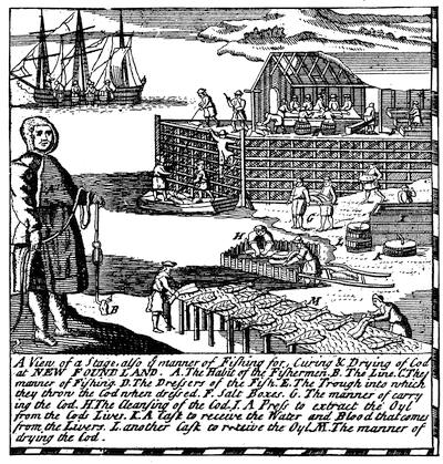
EARLY FISHING STAGES.
[This cut is a fac-simile of one in the corner of A New and Correct Map of America, 1738, which belongs to Sir William Keith’s History of the British Plantations in America: Part I., Virginia, London, 1738. It presumably represents the fashion of these appliances of the fishermen which had prevailed perhaps for centuries.
It was suggested by Forster, Northern Voyages, book iii. chaps. iii. and iv., that Breton fishermen may have been on the Newfoundland coast before Columbus. Scholars are coming more and more to believe the possibility and even probability of it. Every third day in the calendar was then a fast-day, and the incentive to seeking fish on distant seas was great. That Cabot should find the natives of this region calling the cod baccalaos, a name applied by the seamen of the Bay of Biscay to that fish, has also been suggestive; but this story, deducible apparently from no earlier writer than Peter Martyr in 1516, is not altogether trustworthy, since there is doubt if the folk who called the fish by that name were the natives, as Martyr seems to think, or simply the common people, as would seem to be implied in other forms of the statement (see Vol. III. p. 45). Greenland, as we know from the pre-Columbian maps (Ptolemy of 1482, etc.), was considered a part of Europe. Its adjacent shores were in the common mind but further outposts of the same continent; so that the returned sailors’ reports of the distant parts—islands they thought them—might cause no awakening of the idea of a new world. Cf. Navarrete, Viages, iii. 41, 46, 176; Eusebius, Chronicon (1512), p. 172; Wytfliet, Histoire des Indes, p. 131; Lescarbot, Nouvelle France (1618), p. 228; Biard, Relation (1616), chap. i.; Champlain (1632), p. 9; Charlevoix, Nouvelle France, i. 4, 14, or Shea’s edition, i. 106; Estancelin, Navigateurs Normands; Kunstmann, Entdeckung Amerikas, pp. 69, 125; Peschel, Geschichte des Zeitalters, etc., p. 332; Vitet, Histoire de la Dieppe, p. 51; Harrisse, Cabots, p. 271; Kohl, Discovery of Maine, pp. 188, 201, 203, 205, 280; Parkman, Pioneers, p. 171; Mag. of Amer. Hist., 1882, April; N. E. Hist. and Geneal. Reg., 1880, p. 229, etc.—Ed.]
Miguel also was never heard of again. Another expedition, sent out at the expense of the King, a year later, returned without having found a trace of either brother. And yet once more, the oldest of the family, Vasqueanes Cortereal, then governor of Terceira, proposed to undertake the quest in person; but Emanuel refused the necessary permission, declining to risk the lives of more of his subjects.
The Cortereals had no successors among their countrymen in the attempt to reach the Indies by the Northwest Passage; but their voyages opened for Portugal a source of much trade. Individuals, and perhaps companies or associations, soon followed in their track in the pursuit of fish, until the Portuguese enterprises of this sort on the American coasts grew to large proportions, and produced considerable revenue for the State.
The consolidation of France into one great kingdom may be said to date from 1524, when the death of Claude, the wife of Francis I., vested the hereditary right to the succession of Brittany in the crown of France. The marriage of Charles VIII. with Anne, Claude’s mother, in 1491, had brought the last of the feudal fiefs into subjection; but it required many years to make the inhabitants of these provinces Frenchmen, and the rulers at Paris exercised little authority over the towns and principalities of the interior. The coasts of Normandy and Brittany were peopled by a race of adventurous mariners, some of them exercising considerable power; as, for instance, the Angos of Dieppe, one of whom (Jean) was ennobled, and created viscount and captain of that town. Such places as Dieppe, Honfleur, St. Malo, and others had already furnished men and leaders for voyages of exploration and discovery. These had made expeditions to the Canaries and the African coast, and the fishing population of the French provinces were not unused to voyages of considerable length. They were not slow, then, in seeking a share in the advantages offered by the new countries discovered by Cabot and Cortereal, and they speedily became skilful and powerful in the American fisheries. The fishermen of the ports of Brittany are known to have reached the Newfoundland shores as early as 1504. They have left there an enduring trace in the name of Cape Breton, which, in one form or another, is found upon very early maps. Two years afterward Jean Denys, who was from Honfleur, is said to have visited the Gulf of St. Lawrence, and to have made a chart of it; but what now passes for such a chart is clearly of later origin. Another two years elapse, and we read of the voyage, in 1508, of a Dieppe mariner, Thomas Aubert by name, who is said to have brought home the first specimens of the American natives. A contemporary chronicle relates the visit of seven of those savages to Rouen in 1509. The frequency of the voyages of these fishermen and their skill in navigation are proved by the provision in Juan de Agramonte’s commission from the Spanish Crown, in 1511, that he might employ as pilots of his proposed expedition two mariners from Brittany.[11] In 1518, or (as M. d’Avezac thinks) perhaps a few years later, the Baron de Léry attempted a French settlement in the new country. But storms and unfavorable circumstances brought about the failure of this expedition.[12]
We have few particulars of the early life of Giovanni da Verrazano, who commanded the first French expedition sent out under royal auspices. The date of his birth is uncertain; but he is supposed to have been born shortly after 1480, in Florence,—where members of the family had attained high office at various times,—and to have been the son of Piero Andrea da Verrazano and Fiametta Capella. He is said to have travelled extensively, to have passed some years in Egypt and Syria, and to have visited the East Indies. It has also been stated, but on doubtful authority, that he commanded one of Aubert’s ships in that mariner’s expedition to America in 1508. With the year 1521 Verrazano begins to appear in Spanish history as a French corsair; in which character, and under the name of Juan Florin or Florentin, he preyed upon the commerce between Spain and her new-found possessions. It was, perhaps, while engaged in this occupation that he gained the notice and favor of Francis I. Indeed, his voyage of discovery was immediately preceded by, or even connected with, one of these predatory cruises. The Portuguese ambassador in France, Joâo da Silveira, wrote home, April 25, 1523: “Joâo Verezano, who is going on the discovery of Cathay, has not left up to this date, for want of opportunity, and because of differences, I understand, between himself and men.” And Verrazano himself says, in the cosmographical appendix to his letter, that the object of his expedition was to reach Cathay by a westward voyage, and that he expected to be able to penetrate any intervening land. But we know from Spanish sources that in May or June of this same year, 1523, Juan Florin captured the treasure sent home by Cortes to the Emperor, and brought it into La Rochelle; and Verrazano speaks in the beginning of his letter to the King of his success against the Spaniards.[13]
Later in the year, perhaps (but it seems impossible now to separate the voyage of discovery distinctly from the cruise against Spanish commerce), Verrazano started with four ships. Disabled by storms, he was forced to put back into some port of Brittany with two vessels, the “Normandy” and the “Dauphine.” After repairing these, he made a fresh start, but decided finally to proceed on the voyage to Cathay with the “Dauphine” alone.
In this vessel he sailed, Jan. 17, 1524, from the Desiertas Rocks, near the Island of Madeira, having fifty men and provisions for eight months. For twenty-five days he proceeded, with a pleasant breeze, toward the west, without any incident. Then on February 14 (20, according to another version of his letter) he encountered a very violent tempest. Escaping from this, he continued the voyage, changing the course of the vessel more to the north, and in another twenty-five days came within sight of land. This appeared low when first seen; and on a nearer approach it gave evidence, from the fires burning on the shore, that there were inhabitants. This landfall Verrazano places in 34° N., which would be not far from the latitude of Cape Fear, upon the coast of North Carolina; and most commentators upon his letter accept that as the probable point. He began his search for a harbor by coasting south about fifty leagues; but finding none, and observing that the land continued to extend in that direction, he turned and sailed along the shore to the north. Still finding no opportunity to land with the vessel, he decided to send a boat ashore. This was met on its approach to the land by a crowd of the natives, who at first turned to fly, but were recalled by friendly signs, and at last showed the strangers the best place for making a landing, and offered them food. These people were nearly black in color, of moderate stature and good proportions. They went naked except for their breech-cloths, and were, from the description, simple and of kind disposition. The coast is described as covered with small sand-hills, and as pierced by occasional inlets, behind which appeared a higher country, with fields and great forests giving out pleasant odors. There were noticed, also, lakes and ponds, with abundance of birds and beasts. The anchorage Verrazano thought a safe one; for though there was no harbor, he says that the water continued deep very close to the shore, and there was excellent holding-ground for the anchor.
Thence he proceeded along a shore trending east, seeing great fires, which gave him the impression that the country had many inhabitants. While at anchor (perhaps near Raleigh Bay), the boat was sent to the shore for water. There was no possibility of landing, on account of the high surf; so a young sailor undertook to swim to the land, and to give the natives some bells or other trinkets which the French had brought for the purposes of traffic, or for presents. He was overpowered by the waves, and, after a struggle, thrown upon the beach, where he lay almost stunned. The Indians ran down, picked him up, and carried him screaming with fright up the shore. They reassured him by signs, stripped off his wet clothes, and dried him by one of their fires,—much to the horror, says the narrative, of his comrades in the boat, who supposed that the savages intended to roast and eat him. When he was refreshed and recovered from his fright, he made them understand that he wished to rejoin his friends, whereupon the natives accompanied him back to the water, and watched his safe return to the boat.
Following the shore, which here turned somewhat to the north, in fifty leagues more they reached a pleasant place, much wooded, near which they anchored. Here they landed twenty men to examine the country, and made a cruel return for the kindness which the natives had shown the French sailor a short time before. On landing, the men found that the Indians had taken refuge in the woods, with the exception of two women and some small children who had attempted to hide in the long grass. The Frenchmen offered food; but the younger woman refused it, and in great fright called for help to the natives who had fled into the forest. The French took the oldest of the children, a boy of eight, and carried him to their vessel, to take back with them to France. They attempted to kidnap also the young woman, who was handsome and tall, about eighteen years of age; but she succeeded in escaping. The people of this place are described as fairer than those first seen, and the country as fertile and beautiful, but colder than the other.
The vessel remained at anchor three days, and then it was decided to continue the voyage, but to sail only in the daytime, and to anchor each night. After coursing a hundred leagues to the northeast, they arrived at a beautiful spot where, between small steep hills, a great stream poured its waters into the sea. This river was of great depth at its mouth, and with the help of the tide a heavily loaded vessel could easily enter. As Verrazano had good anchorage for his ship, he sent his boat in. This, after going a half league, found that the entrance widened into a magnificent lake of three leagues circuit, upon which at least thirty of the natives’ boats were passing from shore to shore. These people received the strangers kindly, and showed them the best place to bring their boat to the land. A sudden squall from the sea frightened the French, and they returned in haste to the ship without exploring further this pleasant harbor,—which seems to have been that of New York.
Thence they sailed to the east about eighty leagues (fifty, by one account), keeping the land always in sight. They discovered an island of triangular shape, of about the size of that of Rhodes, and about ten leagues from the mainland, to which they gave the name of Louisa, the mother of Francis I.,—the only name mentioned in the narrative. This was covered with woods, and well peopled, as the number of fires showed. From this island, which has been generally identified with Block Island,[14] Verrazano, without landing, as the weather was bad, steered for the coast again; and in fifteen leagues (perhaps retracing his course) came to a most beautiful harbor. Here the ship was met by many boats of the natives, who crowded close around it with cries of astonishment and pleasure. They were easily persuaded to come on board, and soon became very friendly. This harbor, which Verrazano places in the parallel of Rome, 41° 40´ N., and which has been identified as that of Newport, is described as opening toward the south, with an entrance a half league in breadth, and widening into a great bay twenty leagues in circuit. It contained five islands, among which any fleet might find refuge from storms or other dangers. The entrance could be easily guarded by a fort built upon a rock which seemed naturally placed in its centre for defence. The natives are described as fine-looking, the handsomest people seen in the voyage, of taller stature than Europeans, of light color, sharp faces, with long black hair and black eyes, but with a mild expression. The visits of their kings to the strange vessel are described, and the eagerness of these rulers to know the use of everything they saw is mentioned. The women are spoken of as modest in their behavior, and as jealously guarded by their husbands. The interior country was explored for a short distance, and found pleasant and adapted to cultivation, with many large open plains entirely free from trees, and with forests not so dense but that they could easily be penetrated.
In this agreeable harbor, where everything that he saw filled him with delight, and where the kindness of the inhabitants left him nothing to desire, Verrazano tarried fifteen days. Then having supplied himself with all necessaries, he departed on the 6th of May (Ramusio says the 5th), and sailed a hundred and fifty leagues without losing sight of the land, which showed small hills, and was a little higher than before, while the coast, after about fifty leagues, turned to the north. No stop was made, for the wind was favorable, and the nature of the country appeared much the same. The next landing was made in a colder country, full of thick woods, where the natives were rude, and showed no desire to communicate with the strangers. They were clothed in skins, and their land seemed barren. They would accept nothing in barter but knives, fish-hooks, and sharpened steel. When the French landed and attempted to explore the country, they were attacked. This landing has been placed somewhere north of Boston, possibly not far from Portsmouth, in New Hampshire.
The voyage was continued in a northeasterly direction. The coast appeared pleasanter, open, and free from woods, with a sight of high mountains far inland. Within a distance of fifty leagues thirty-two islands were discovered, all near the shore, which reminded the navigator of those in the Adriatic. He did not stop to explore the country, or to open communication with the natives, but continued another hundred and fifty leagues in the same general direction, when he arrived at about the latitude of 50° N. Here, having reached the country already discovered by the Bretons, and finding his provisions and naval stores nearly exhausted, he took in a fresh supply of wood and water, and decided to return to France, having, he says, discovered more than seven hundred leagues of unknown territory. He arrived at Dieppe on his return early in July, for his letter to the King is dated from that port on the 8th of the month.
We lose trace of Verrazano after his return from this voyage. Francis I. was in no condition to profit from the opportunity offered him to colonize a new world. He had engaged in a struggle with the Emperor; was soon after the date of this letter busily occupied in fighting battles; and at that of Pavia, Feb. 24, 1525, was taken prisoner, and spent the next year in captivity in Spain. It has been suggested that Verrazano went to England, and there offered his services to Henry VIII., and there are contemporary allusions supporting the suggestion. Mr. Biddle, in his Memoir of Sebastian Cabot, advances the opinion that Verrazano was the Piedmontese pilot who was killed and eaten by the savages in Rut’s expedition of 1527, which would harmonize Ramusio’s statement that he made a second voyage to America and lost his life there. But this is extremely doubtful.[15] We know from French sources that in 1526 Verrazano joined with Admiral Chabot, Jean Ango, and others, in an agreement for a voyage to the Indies for spices, with a proviso inserted for the equitable division of any booty taken “from the Moors or others, enemies of the faith and the King our lord.” Spanish documents of official character show that Juan Florin, with other French pirates, was captured at sea in 1527, and hung at the small village of Colmenar, between Salamanca and Toledo, in November of that year. But it has been also lately stated that a letter has been found, dated at Paris, Nov. 14, 1527, which speaks of Verrazano as then preparing an expedition of five ships for America, expecting to sail the following spring. If this statement is accurate, and the date of the letter has been correctly read, grave doubts are thrown upon the Spanish story of his execution. Either Florin was not Verrazano, or he was not hanged at the time stated. I cannot undertake to reconcile all these statements, but must leave them as I find them.
The voyage of Estévan (Stephen) Gomez, although not made under the flag of France, should, perhaps, be studied in connection with that of Verrazano. Spain did not fail to take notice of the discoveries of the Cabots when the news of the return of Sebastian from the second voyage reached London in 1498. Her ambassador at that Court, Don Pedro de Ayala, in his despatch dated July 25 of that year, says that he has given notice to the English king that the countries discovered by Cabot belonged to his master. There are traces of voyages in a northwestern direction under Spanish auspices in subsequent years. Navarrete thinks that such was the object of the Spanish king in sending for Juan Dornelos, or Dorvelos, in the spring of 1500. It is stated also that Hojeda had orders about the same time to follow the English tracks. The commission to Agramonte in 1511 (he having proposed a similar project previously) was for the purpose of planting a settlement in the tierra nueva at the northwest. Magellan’s discovery of the long-sought strait through the New World leading to the Land of Spices, although it brought no immediate advantages, as the voyage was long and perilous, revived and increased the interest in seeking for a shorter and more northern passage. The agreement made with De Ayllon, June 12, 1523, provided, among other things, for the search for another way through the continent to the Moluccas, to be found north of Florida. Hernando Cortes wrote home to the Emperor, Oct. 15, 1524, a letter on the probability of there being such a passage easier than the one already discovered, and proposed to seek for it. Gomez was of the same opinion, for his voyage was undertaken to find this northern strait.
Estévan Gomez was a Portuguese and an experienced navigator. He had entered the service of Spain a few years before this time, having received the appointment of pilot in 1518 at the same time that Sebastian Cabot was created “pilot major.” He had sailed with Magellan on his great voyage as pilot of the “San Antonio,” but had joined the crew of that vessel in their mutiny against her captain, Alvaro de Mesquita, at the strait. He thus deserted Magellan, and brought the ship home. In 1521 he was ordered to serve with the fleet which was then preparing to sail against the French corsairs. He obtained a concession from the Emperor, dated March 27, 1523, by which he was to have a small vessel for an expedition to the northwest, armed and provisioned for one year. Although this grant, like that made soon afterward to De Ayllon, contained a proviso that the expedition should carefully avoid trespassing upon the King of Portugal’s possessions in the New World, that Power seems to have raised objections to the voyage. The following year a council was convened at the small town of Badajos for the settlement of the rival claims of Spain and Portugal, and Gomez was sent with Cabot, Juan Vespucius, and others to this council,—not as members, but in the capacity of specialists or experts, to give opinions on questions of navigation and cosmography. The congress accomplished nothing in the way of an agreement between the rival Powers, and after its adjournment the Council for the Indies decided to allow the voyage proposed by Gomez.
Gomez sailed from Corunna, a port in the north of Spain, to which the “Casa de Contratacion,” or India House, had been removed from Seville, some time in February of the following year (1525), and was absent about ten months. We have unfortunately no detailed account of his voyage, and it does not now seem possible to say with certainty even in which direction he explored the American coast. The accounts given by the Spanish historians are very meagre. They seem to have paid little attention to the voyage, except to record its failure to discover the desired northern strait. The Spanish maps, however, show plain traces of the voyage, in the Tierra de Estévan Gomez, the name applied by Ribero and others to the large tract of country between Cape Breton and Florida. Gomara, one of the earliest and best authorities on American matters, heads the chapter which he devotes to Gomez, “Rio de San Antonio,” which name is supposed to be the one given in Spanish maps to the Hudson River. Gomez is said to have visited the country at latitudes 40° and 41° north, and to have coasted a great extent of land never before explored by the Spaniards. It is related also that he visited the Island of Cuba, and refitted his vessel there. This would be presumably on the homeward voyage. Failing to obtain the rich cargo of spices which he had expected to bring home, he loaded his vessel with kidnapped savages of both sexes, and with this freight reached Corunna again in November, 1525.
All historians of the voyage made by Gomez have told the story about the mistake of a zealous newsmonger in reference to the nature of the cargo thus brought home. Peter Martyr is the first to tell it, in the final chapter of his last decade, inscribed to Pope Clement VII., written in 1526. In answer to a question as to what he had brought, Gomez was understood to reply “cloves” (clavos), when he really said “slaves” (esclavos). The eager friend hastened to Court with the news that the shorter strait had been discovered, thinking to obtain some reward for his intelligence. The favorers of Gomez’ project (in regard to which there appears to have been some difference of opinion) greeted the news with applause, but were covered with ridicule when the true story of the results of the voyage was published. Martyr quaintly says: “If they hadd learned that the influence of the heauens could bee noe where infused into terrestriall matters prepared to receiue that aromaticall spirit, saue from the Æquinoctiall sunne, or next vnto it, they woulde haue knowne that in the space of tenn moneths (wherein hee performed his voyage) aromaticall Cloues could not bee founde.”[16]
It does not fall within the limits of this chapter to relate the story of the early attempts of the French Huguenots to plant colonies in this country.[17] But I may refer very briefly to the first of these,—the expedition sent by Admiral Coligny to Brazil under the command of Villegagnon, in 1555; as a Franciscan monk, André Thevet, who accompanied it, claims to have coasted the continent of North America on his return voyage to France the next year.
Thevet says of himself that he had spent the early years of his life in travel, and that he had already made a voyage to the East, of which voyage, and of his skill in navigation, his friend Villegagnon was well aware when he asked him to join the proposed expedition to South America,—an offer which he (Thevet) was very ready to accept. The start, he says, was made from Havre, May 6, 1555, and the voyage across the ocean was long and tedious. It was not until the last day of October that, about nine o’clock in the morning, their vessel came within sight of the high mountains of Croistmourou. These were within the limits of a country whose inhabitants were friends of the Portuguese, and the French therefore decided to avoid landing there. They continued the voyage, and seventeen days later cast anchor at the River Ganabara (Rio Janeiro), where they were received in a friendly manner by the natives, and decided to make their settlement.
Thevet remained with the colony only about ten weeks, leaving on his homeward voyage, Jan. 31, 1556. He says that the commander of the vessel decided to return by a more northern passage than that by which he had crossed from France; and goes on to describe at some length their voyage along the coast, and to give many particulars of the countries and natives, most of which he must have obtained from other travellers’ books and histories after his return. The progress was slow. At the Cape of St. Augustine the vessel was delayed, he says, two months in the attempt to round that promontory. The equinoctial line was not crossed until about the middle of April; and after leaving Espagnola a contrary wind blew them in toward the coast.
Thevet claims to have coasted the entire shore of the United States, and gives occasional accounts of what he saw, and of intercourse with the natives. But his details are always uncertain, and the places he professes to have visited cannot be identified. No satisfactory information can be obtained from his story; and indeed his reputation for truth-telling is so poor that many historians are inclined to reject altogether his recital of the voyage along our coast. It may well be that Thevet invented the whole of it as a thread upon which to hang the particulars about Florida, Norumbega, and other countries which he gathered from books. After his return to France he was made aumonier to Catherine de Medicis, and also royal historiographer and cosmographer.

CRITICAL ESSAY ON THE SOURCES OF INFORMATION.
THE earliest mention in print of the Cortereal voyages is found in a small collection of travels (one of the very earliest collections made), entitled Paesi novamente retrovati. This was published at Vicenza, in Italy, as the colophon states, Nov. 3, 1507, and is supposed to have been compiled by Fracanzio da Montalboddo, or by Alessandro Zorzi.[18] The account of Gaspar Cortereal is contained (book vi. chap. cxxv) in a letter written from Lisbon, Oct. 19, 1501 (eleven days only after the return of the first vessel which succeeded in getting home from the second voyage), by the Venetian ambassador in Portugal, Pietro Pasqualigo, to his brothers. This is, of course, an authority of great value. The writer gives a brief account of the voyage, speaks of the customs of the inhabitants of the new country, and describes the captives which the ship had brought. He says that the other vessel is expected immediately. Pasqualigo mentions, however, only one voyage, and has apparently confused it with the earlier one; for he says that the expedition sailed “lāno passato” (that is 1500), and writes of the failure to reach a country discovered “lanno passato.” Perhaps he received some account of both voyages from the mariners, and in preparing his letter failed to preserve the distinction between them. French versions of the letter appeared in Paris in 1517 and 1522. An English translation of the interesting portions of this letter is given in Biddle’s Cabot, at pp. 239, 240.
Another contemporary account of this voyage of Gaspar Cortereal has lately been discovered. M. Harrisse has obtained from the archives of Modena a despatch sent to Hercules d’Este, Duke of Ferrara, by Alberto Cantino, his representative at Lisbon, in which the arrival of the second vessel (expected immediately in Pasqualigo’s letter) is reported. This despatch is dated Oct. 17, 1501. The vessel arrived on the 11th,—three days after the first one,—and brought the expected cargo of slaves. Cantino says that he saw, touched, and surveyed (li quali io ho visti, tochi et contemplati) these natives. He gives some account of the savages, and tells the story of the voyage as he heard the captain of the vessel relate it to the King, being present at their interview. The caravel had been a month on her return, and the distance was two thousand eight hundred miles,—“Questo naviglio è venuto di la a qua in un mese, et dicono esservi 2,800 milia de distantia.” Cantino makes no mention of the return of the first vessel, but speaks of a third, commanded by Cortereal in person, as having decided to remain in the new country, and to sail along its coast far enough to discover whether it were an island or terra firma,—“Laltro compagno ha deliberato andar tanto per quella costa, che vole intendere se quella è insula, o pur terra ferma.”
Harrisse prints this interesting letter of Cantino in his Jean et Sébastian Cabot (pp. 262-264). Cantino appears to have also sent his master a map showing the new discoveries. This map Harrisse has since reproduced with a commentary, in his work on the Cortereals, as explained in the second volume of the present history.
It should be noted that Harrisse counts three voyages of Gaspar Cortereal,—the first, without result, before May, 1500; the second, between May and December of that year; and a third, sailing in January, 1501,—the return of two of whose vessels in the following October is related by Pasqualigo and Cantino.[19]
The confusion of the voyages continued. The Spanish historians and those of Italy, knowing, perhaps, of only one, or getting their information from the Paesi and the maps, speak of but one expedition. Gomara, whose work was published at Saragossa in 1552-1553,[20] says that Cortereal was seeking a northwest passage, but failed to find it; that he gave his name to the islands at the mouth of the St. Lawrence in 50° N.; and that, dismayed at the snow and ice, he returned home with about sixty of the natives whom he had captured.[21] Herrera, who published his History early in the next century,[22] gets his information from Gomara. Peter Martyr does not mention the Cortereals. Turning to Italy, we find in Ramusio an account of Cortereal in the third volume of his great collection of voyages,[23] published in 1556, at fol. 417. Here, in an introductory discourse, written by Ramusio himself, “sopra la terra ferme dell’ Indie Occidentali,” it is stated that Gaspar Cortereal was the first captain who went to that part of the New World which “runs to the north,” in 1500, with two ships, in search of a shorter passage to the Spice Islands; that he penetrated so far north as to get into a region of great cold, discovering at 60° a river filled with snow, which was called the “Rio Nevado;” that he found inhabited islands to which he gave names, etc.
Even down to modern times the distinction between the voyages has not been recognized. Biddle, Humboldt, and others speak of only one expedition. The Portuguese authorities, however, are explicit in the matter. In 1563 there was published at Lisbon a volume of navigations and discoveries written by Antonio Galvano, who had died a few years before.[24] Galvano was born at Lisbon in 1503. He went, a young man, to India, and distinguished himself there, having command of the expedition which reduced the Moluccas to Portuguese rule, and becoming the governor of Ternate,—the largest of these islands. He was recalled home, and coldly received by the King. Becoming indigent, he was forced to take refuge in a hospital, where he finally died in 1557. His papers were bequeathed to a friend, Don Francisco y Sousa Tavares, who prepared the volume for the press. Galvano gives a good account of the expedition of Gaspar Cortereal, clearly dividing it into two voyages; and he tells also of Miguel Cortereal’s attempt to discover his brother’s fate. The original Portuguese text is very rare. Hakluyt published a translation of it in 1601,[25] and states in his Dedication of that book to Sir Robert Cecil that he could not succeed in finding a copy of the original. The translation was made, he says, “by some honest and well-affected marchant of our nation, whose name by no meanes I could attaine unto, and that, as it seemeth, many yeeres ago. For it hath lien by me above these twelve yeeres.” In 1862 the Hakluyt Society of London reprinted this translation under the editorial supervision of Vice-Admiral Bethune. In this edition corrections of the English version are noted, and the whole Portuguese text is given, page for page, from a copy of the original in the Carter-Brown Library. The passage relating to the Cortereals is found at pages 96, 97, of this Hakluyt Society’s volume.[26]
The Chronicle of King Emanuel, by Damiano de Goes, appeared at Lisbon in 1565-1567.[27] Goes was born in 1501, and died about 1573. He was employed in the diplomatic service of Portugal in Flanders, Denmark, and other countries, and travelled extensively. Galvano considered him, as a traveller, worthy of mention in his work, and says that he visited England, France, Italy, Germany, Poland, Muscovy, and Norway. “He did see, speake, and was conuersant with all the kings, princes, nobles, and chiefe cities of all Christendome in the space of 22 yeeres (occupied in the work); so that by reason of the greatnes of his trauell I thought him a man woorthie to be here remembred.”[28] He became afterward historiographer of Portugal, and was placed in charge of the public archives. But he fell under the ban of the Inquisition, and died in obscurity. His account of the Cortereals, which is clear and of great value, from the learning of the writer and from his excellent opportunities to inform himself, is given in the sixty-seventh chapter of the first part of the Chronicle, at pp. 87, 88.[29]
Hieronymus Osorius (as his name is Latinized), the Bishop of Silves,—known sometimes as the Portuguese Cicero, from the elegance of his style,—published his De rebus Emmanuelis in 1571.[30] He was born in 1506, and lived until 1580. His writings include treatises on philosophy and theology, as well as works of history. In the Chronicle, under date of 1503, he gives a full account of the Cortereal voyages, including the search expedition sent out by the King that year, and the proposition of the eldest brother to equip a new exploration. The story may be found at p. 63 of the edition of 1586.
Oscar Peschel and Friedrich Kunstmann, in Germany, used these Portuguese authorities freely in their accounts of the Cortereals. Peschel’s book, an excellent one, Geschichte des Zeitalters der Entdeckungen, was published at Stuttgart in 1858, and went to a second edition in 1877. The discoveries of the Portuguese are treated in the ninth chapter of the second book.[31] Kunstmann’s work, of great learning and research, Die Entdeckung Amerikas, was published at Munich in 1859 by the Royal Bavarian Academy of Sciences, as part of the centennial commemoration (March 28, 1859) of its foundation. In addition to the printed authorities, Kunstmann instituted searches among the manuscript archives at Lisbon. He had the pretended early voyage of Joâo Vaz Cortereal examined, and ascertained that there was no foundation for it.[32] He found the letter of Miguel Cortereal, written Aug. 6, 1501, to Christovâo Lopez, which has been used in the preceding narrative; and that brother’s agreement with the King, Jan. 15, 1502, by which the grant previously made to Gaspar was continued to Miguel.[33]
An excellent account of the Cortereal voyages, based largely upon Kunstmann’s researches, is given by Dr. Kohl in the fifth chapter of his Discovery of Maine.[34] At the first session of the International Congress of “Américanistes,” held at Nancy in July, 1875, M. Luciano Cordeiro, professor in the Institut at Coïmbre, presented, through M. Lucien Adam, an elaborate essay on the share of the Portuguese in the discovery of America. M. Cordeiro’s paper shows great industry and research, but it should be read with caution, as his patriotism sometimes exceeds his discretion. He looks at everything with the distorted vision of an enthusiastic lover of his native land.[35]
With Kunstmann’s Entdeckung, the Bavarian Academy published, under the care of that gentleman, Karl von Spruner, and Georg M. Thomas, an elegant atlas of thirteen maps in beautifully executed colored fac-similes. Portions of three of these maps relating to the Cortereals are given in a greatly reduced form, without the brilliant colors, by Dr. Kohl, in the Appendage to his chapter on these navigators. The first of these is a Portuguese chart, made about 1504 by an unknown hand. The southern part of Greenland is laid down upon it without a name; and farther to the west appears a considerable extent of country, answering, perhaps, to parts of our Labrador and Newfoundland, which bears the name “Terra de cortte Reall.”[36] The second chart, made by Pedro Reinel at about the same period, shows only Portuguese names and gives the Portuguese flag on that part of America visited by the Cortereals. Reinel was a Portuguese pilot of eminence, who afterward entered the Spanish service. The third map, also of Portuguese origin, of about the year 1520, although its exact date and its author’s name are unknown, contains at Labrador these words: “terram istam portugalenses viderunt atamen non intraverunt” (“The Portuguese saw this country, but did not enter it”); and again at a place farther west occurs the legend: “Terram istam gaspar corte Regalis portugalensis primo invenit, et secum tulit hōīes silvestres et ursos albos. In ea est maxiā multitudo animalium et avium necnon et pescium. qui anno sequenti naufragium perpessus nunquam rediit: sic et fratri ejus micaeli anno sequenti contigit” (“This country was first discovered by Gaspar Cortereal, a Portuguese, and he brought from there wild and barbarous men and white bears. There are to be found in it plenty of animals, birds, and fish. In the following year he was shipwrecked, and did not return: the same happened to his brother Michael in the next year”).[37]
The original authorities for the early French expeditions have, unhappily, not been preserved, or they still lie hidden in some dusky receptacle, baffling all search for them. The Breton fishermen perhaps wrote no accounts of their voyages across the Atlantic; but we might hope for some authentic reports of the voyages of Denys, Aubert, and others, made under the auspices of the rich and powerful Angos. The archives of Dieppe, however, were destroyed at the bombardment of that town in 1694, and those of La Rochelle met a similar fate.
The earliest mention of these transatlantic voyages that we now find occurs in a discourse attributed to a great French captain of Dieppe, preserved in an Italian translation by Ramusio, in his collection of voyages.[38] This discourse gives a summary description of the new countries, and a very brief mention of their discoverers. From internal evidence it appears to have been written in 1539. Ramusio, in introducing it, expresses his regret that he could not ascertain the name of its author. M. Louis Estancelin published in 1832 a journal of the voyage made by Jean Parmentier to Sumatra in 1529, which corresponds so exactly with the details of a similar voyage in the great captain’s discourse as to make it evident that Parmentier was the person described by Ramusio under that title.[39] This discourse mentions the voyages of Denys and Aubert, and speaks of Verrazano as the discoverer of Norumbega. From this source other writers have generally drawn their authority for these early voyages. The Chronicle of Eusebius,[40] however, contains an account of the visit of American savages to Rouen in 1509; and there is a curious bas-relief over a tomb in the Church of St. Jacques at Dieppe, in which American natives are represented.[41] Charlevoix speaks of the map which Jean Denys is said to have made.[42]
The authorities for the voyage of Verrazano are two copies of his letter, written to the King of France from Dieppe July 8, 1524, on his return from the voyage. Both of these are, however, Italian translations of the letter, the original of which does not exist. One was printed by Ramusio in 1556, in the third volume of his collection of voyages.[43] The other was found many years later in the Strozzi Library (the historical documents in which were afterward transferred to the Magliabechian, now merged in the National Library) in Florence, and was first published in 1841 by the New York Historical Society, with a translation made by Dr. J. G. Cogswell.[44] This contained a Cosmographical Appendix not in the copy printed by Ramusio. The earlier printed version was translated into English by Hakluyt for his Divers Voyages, which appeared in London in 1582, and was incorporated by him into his larger collection published in 1600.[45] Dr. Cogswell’s translation was reprinted in London by Dr. Asher in his Henry Hudson the Navigator, prepared for the Hakluyt Society in 1860.[46] Dr. Asher considers the Cosmographical Appendix a document of great importance. With this Strozzi copy there was found a letter written by one Fernando Carli from Lyons, Aug. 4, 1524, to his father in Florence, accounting for sending Verrazano’s letter, which Carli thought would interest his countrymen. This letter of Carli was first printed in 1844, with the essay of George W. Greene on Verrazano, in the Saggiatore (i. 257), a Roman journal of history and philology. Professor Greene, who was the American Consul at Rome, had been instrumental in obtaining the Verrazano letter for the New York Society, and had previously published his essay in the North American Review for October, 1837. He reprinted it in his Historical Studies. Carli’s letter may be consulted in English translations in Mr. Smith’s, Mr. Murphy’s, and Mr. Brevoort’s essays on Verrazano.
References to the voyage occur occasionally in French, English, and Spanish authors;[47] and it was not until within a few years that any doubt was thrown upon the authenticity of the narrative.
In October, 1864, Mr. Buckingham Smith, an accomplished scholar, who had been secretary of the American Legation at Madrid, read a paper upon this subject before the New York Historical Society, afterward published the same year under the title, An Inquiry into the Authenticity of Documents concerning a Discovery in North America claimed to have been made by Verrazzano. Mr. Smith’s death interrupted an enlarged and revised edition of this essay, which he was urged to prepare.[48] Mr. J. Carson Brevoort presented a paper on Verrazano, taking an opposite view, to the American Geographical Society, in 1871, which he printed three years later, entitled Verrazano the Navigator.[49] This was followed by the appearance, in 1875, of Mr. Henry C. Murphy’s The Voyage of Verrazzano, in which he makes an able plea against the genuineness of the accounts of the voyage. This book caused considerable discussion, and has been answered several times. It remains, I think, the last word on that side of the question,—except that Mr. Bancroft has omitted all notice of Verrazano in the revised edition of his History of the United States, and the editors of Appleton’s American Cyclopædia seem to adopt Mr. Murphy’s conclusions. Mr. Murphy’s book was reviewed by Harrisse in the Revue critique for Jan. 1, 1876, and his conclusions were accepted with some reserve. It was noticed unfavorably by Mr. Major in the London Geographical Magazine (iii. 186) for July, 1876 (copied from the Pall Mall Gazette of May 26, 1876), and by the Rev. B. F. De Costa in the American Church Review of the same date. In 1878-1879 papers on this subject by De Costa appeared in the Magazine of American History, which were afterward collected and revised by their author, and issued, with the title, Verrazano the Explorer, in 1881. This work contains an exhaustive bibliography of the subject, to which reference should be made.[50] In this same year, 1881, M. Cornelio Desimoni, vice-president of the “Società Ligure di Storia Patria,” printed in the fifteenth volume of the Atti of that Society a second Studio on Verrazano, in which he takes strong ground in favor of the genuineness of the voyage. This essay had been presented to the third congress of “Américanistes,” which met at Brussels in 1879. M. Desimoni had previously contributed to the Archivio Storico Italiano for August, 1877, an article upon this navigator,[51] but was able to review Mr. Murphy’s book only from notices he had seen of it. In a note at the end of his paper he states that he had procured a copy, and, so far from finding any reason to modify the views he had expressed, he thought that he could find in Mr. Murphy’s essay additional arguments for the authenticity of the voyage. The second Studio was followed by what M. Desimoni modestly calls a Third Appendix (the Studio having two Appendices printed with it). This is a paper of considerable importance, as it contains the reproduction of the map of which I shall speak later.[52]
Hieronimo da Verrazano, the brother of the navigator, made about 1529 a large mappamundi, on which the discoveries of Giovanni are laid down.[53] This map is preserved in the Borgiano Museum of the College “di Propaganda Fide” in Rome. It is not certain that the map is an original; and it was first mentioned by Von Murr in his Behaim, Gotha, 1801, p. 28, referring to a letter of Cardinal Borgia of Jan. 31, 1795, regarding it. It was again referred to in Millin’s Magazin encyclopédique, vol. lxviii. (1807); but general attention was first directed to it by M. Thomassy in 1852, in a communication published in the Nouvelles Annales des Voyages.[54] Mr. Brevoort[55] has given a description of it, which he prepared from two photographs, much reduced in size, made for the American Geographical Society in 1871. These photographs were not large enough nor sufficiently distinct to allow the names of places on the American coast to be read. This North American section of the map was first given with the names by Dr. De Costa, who had made a careful examination of the original during a visit to Rome, in the Magazine of American History for August, 1878.[56]
This map is not dated; but the following legend, placed at the position of Verrazano’s discoveries, fixes the date for 1529: “Verrazana sive nova gallia quale discoprì 5 anni fa giovanni da verrazano fiorentino per ordine e Comandamento del Cristianissimo Re di Francia” (“Verrazana, or New Gaul, which was discovered five years ago by Giovanni di Verrazano, of Florence, by the order and command of the most Christian King of France”).
One of the most interesting of the maps which show the traces and influence of Verrazano’s voyage is the copper globe known as the globe of Ulpius, from its maker, Euphrosynus Ulpius, constructed (as appears by an inscription on it) in 1542. This was found in Spain by the late Buckingham Smith, and bought for the New York Historical Society in 1859 by Mr. John D. Wolfe. Mr. Smith prepared a paper on this globe, which was printed, with a map of the portion relating to North America, in the Historical Magazine in 1862.[57] Dr. De Costa published, in the Magazine of American History for January, 1879, an excellent account of the globe of Ulpius, with a representation of one hemisphere, which, he says, “without being a fac-simile, is nevertheless sufficiently correct for historical purposes, and may be relied upon.”[58] On this globe, between Florida and the “Regio Baccalearum,” we find this inscription, covering a large extent of territory: “Verrazana sive Nova Gallia a Verrazano Florentino comperta anno Sal MD.” (“Verrazana, or New Gaul, discovered by Verrazano the Florentine, in the year of Salvation MD.”). It will be observed that the date has been left incomplete.
Other maps showing traces of Verrazano’s voyage are enumerated by Kohl, Brevoort, and De Costa, the account by the last-named being the latest, and perhaps the most complete.[59]
The controversy about this letter and voyage of Verrazano has excited so much interest, that it is well to give a concise summary of Mr. Murphy’s objections to the genuineness of the voyage, and to consider with equal brevity some of the replies to these objections, and the additional evidence for the support of the narrative which has been discovered since the date of Mr. Murphy’s essay.
The conclusions which Mr. Murphy seeks to establish are set forth in the following brief:—
“That the letter, according to the evidence upon which its existence is predicated, could not have been written by Verrazzano; that the instrumentality of the King of France in any such expedition of discovery as therein described is unsupported by the history of that country, and is inconsistent with the acknowledged acts of Francis and his successors, and therefore incredible; and that its description of the coast and some of the physical characteristics of the people and of the country are essentially false, and prove that the writer could not have made them from his own personal knowledge and experience, as pretended; and, in conclusion, it will be shown that its apparent knowledge of the direction and extent of the coast was derived from the exploration of Estévan Gomez, a Portuguese pilot in the service of the King of Spain; and that Verrazzano, at the time of his pretended discovery, was actually engaged in a corsairial expedition, sailing under the French flag, in a different part of the ocean.”[60]
Mr. Murphy argues, first, that the letter is not genuine, because no original has ever “been exhibited, or referred to in any contemporary or later historian as being in existence; and, although it falls within the era of modern history, not a single fact which it professes to describe relating to the fitting out of the expedition, the voyage, or the discovery, is corroborated by other testimony, whereby its genuineness might even be inferred.”[61] He considers it “highly improbable” that there could have been a French original of the letter, from which two translations were made, with an interval of twenty-seven years between them, “and yet no copy of it in French, or any memorial of its existence in that language, be known.”[62] As the Carli copy contains a Cosmographical Appendix not in the Ramusio text, Mr. Murphy assumes that Ramusio took his version from the Carli manuscript, revising it, and changing its language to suit his editorial taste. Later in his book he goes farther, and accuses Ramusio of suppressing a fact here and adding another there, to make the Verrazano narrative agree with other documents in his possession. As Carli’s letter to his father covered his copy of Verrazano’s letter, the inquiry is narrowed down to a question of the authenticity of the Carli letter. Mr. Murphy argues that this letter cannot be genuine, because it was written by an obscure person, at a great distance from the French Court, and from Dieppe (the port from which Verrazano wrote), only twenty-seven days after the date of the letter which it pretended to enclose.
Mr. Murphy, in the next division of his argument, asserts that no such voyage was made for the King of France:—
“Neither the letter, nor any document, chronicle, memoir, or history of any kind, public or private, printed or in manuscript, belonging to that period or the reign of Francis I., who then bore the crown, mentioning or in any manner referring to it, or to the voyage and discovery, has ever been found in France; and neither Francis himself, nor any of his successors, ever acknowledged or in any manner recognized such discovery, or asserted under it any right to the possession of the country; but, on the contrary, both he and they ignored it, in undertaking colonization in that region, by virtue of other discoveries made under their authority, or with their permission by their subjects.”[63]
He claims that the accounts of Verrazano’s voyage given by French historians all show internal evidence that the information was derived from Ramusio. The life of Francis I., he further says, is a complete denial of the assertion that Verrazano’s voyage was made by his direction. Francis sent out the expeditions of Cartier and of Roberval, and yet never recognized the discovery made by Verrazano. And the map, sometimes called that of Henry II. (the date of which, however, has been supposed to be some years earlier than the accession of that monarch in 1547), an official map displaying all the knowledge the French Court possessed of the American coast, is destitute of any trace of Verrazano.[64]
Mr. Murphy considers next what he calls the misrepresentations in the letter in regard to the geography of the coast. Only to one place, an island, is a name given. A very noticeable omission is that of the Chesapeake Bay, which could not have been overlooked by an explorer seeking a passage to Cathay; and not even the named island really exists: there is none on the coast answering its description.
He next undertakes to show that the letter claims the discovery of Cape Breton and the southerly coast of Newfoundland; and that Ramusio, knowing this claim to be false, “deliberately” interpolated into his text a clause to limit Verrazano’s discoveries to the point where those of the Bretons began.
Mr. Murphy argues next that “the description of the people and productions of the land [were] not made from the personal observation of the writer of the letter. What distinctively belonged to the natives is unnoticed, and what is originally mentioned of them is untrue.”[65] He thinks that all the details given of Indian manners and customs may have been copied from well-known narratives of other visits to other parts of America, and instances a source whence they may have been drawn. Fault is found with Verrazano’s letter because it neglects to mention such peculiarities of the Indians as wampum, tobacco, and, “most remarkable omission of all,” the bark canoe. The falsity of the narrative, made probable by these omissions, is rendered certain by the positive statement of a radical difference in complexion between the tribes found in different parts of the country.[66] And, again, the condition in which plants and vegetation are described is equally absurd and preposterous. And so both in the case of the color of the natives and in that of the conditions of the grapes, Ramusio, says Mr. Murphy, is obliged to alter the text of the narrative to make these stories probable.
The extrinsic evidence in support of the Verrazano discovery is next considered. As Mr. Murphy knew this evidence, it consisted of two pieces,—the Verrazano map, and the discourse of the great French sea-captain. The map was known, at the time of the printing of Mr. Murphy’s essay, only by description and by two inadequate photographs. Our present information about this map is so much greater, that Mr. Murphy’s account of it may be passed over until the map itself is described, later. The French captain’s discourse is known only in the Italian translation printed by Ramusio, and placed in his third volume, immediately after the Verrazano letter. Mr. Murphy dismisses this piece of evidence with few words. Finding in the discourse a clause relating to Verrazano, he at once concludes that Ramusio interpolated it, to make this document consistent with the letter.
A skilled advocate, after proving to his own satisfaction the falsity of a document, likes to find some genuine story which may have served the concocters of the falsehood as a model and storehouse for their lies. He wants also to complete his case by showing the motive for the forgery. This motive Mr. Murphy finds in the civic pride of Florence. All the evidence in favor of the story is traceable, he says, to Florence. As for the model and source of the letter, he discovers these in an attempt “to appropriate to a Florentine the glory which belonged to Estévan Gomez, a Portuguese pilot ... in the service of the Emperor.” He gives the voyage of Gomez in pretty full details. The landfall occurred on the coast of South Carolina. Thence he ran the coast northwardly to Cape Breton, where he turned and retraced his track as far as Florida, returning to Spain by way of Cuba. Mr. Murphy brings forward the map of Ribero, made in 1529, which he claims as an official exhibition of the discoveries of Gomez, and which he thinks was used in the construction of the Verrazano letter, because the several courses and distances run, as described in the letter, agree with similar divisions on the map.[67]
Mr. Murphy adds a concluding chapter, in which he gives the true history of the life of Verrazano, as he gathers it from authentic sources. Beyond his birth and parentage nothing is perhaps certainly known, except his career as a French corsair, under the name of Juan Florin or Florentin. In this capacity he made several rich captures from the Spanish and Portuguese, notably the treasure sent home by Cortes in 1523. Mr. Murphy thinks that a passage in a letter of the Portuguese ambassador in France, which appears to refer to preparations for a voyage of discovery about this time, is really an allusion to the proposed raid, the other being used by the French as a cloak or cover. At all events, he says, Verrazano cannot have been in two places at once,—on the coast of America, or on his return from Newfoundland to France, and at the same time have taken a ship on her way from the Indies to Portugal. He cites, as authority for this alibi, a statement of the capture of a treasure ship brought by a courier from Portugal, and mentioned in a letter of Peter Martyr, dated August 3, 1524.[68] Mr. Murphy then closes with an account of the capture and execution of Florin, or Verrazano.
Mr. Murphy’s argument is an ingenious and able one; and the book, having never been published, is not within the reach of all.[69]
To the objections named in the first divisions of Mr. Murphy’s argument,—that the letter could not have been written by Verrazano, and that no such voyage or discovery was made for the King of France,—replies suggest themselves very easily. We have no originals of many important documents, and yet do not doubt their general accuracy,—the letters of Columbus and Vespucius, for instance; the original French of Ribault; and, to come closer to Mr. Murphy, where is the report of Gomez’ voyage? There is none; and its only supports are an occasional not too flattering reference in the historians, and a map made by another hand. The despised voyage of Verrazano rests upon both a personal narrative and a map, the work of a brother.[70]
Mr. Murphy himself furnishes corroborative testimony to the probable truth of Verrazano’s voyage. He cites a passage from Andrade’s Chronicle of John III., then King of Portugal. By this it appears that John learned that one “Joâo Varezano, a Florentine,” had offered to the King of France to “discover other kingdoms in the East which the Portuguese had not found, and that in the ports of Normandy a fleet was being made ready under the favor of the admirals of the coast and the dissimulation of Francis, to colonize the land of Santa Cruz, called Brazil,” etc. The Portuguese King lost no time in sending a special ambassador, João da Silveyra, to remonstrate; and Mr. Murphy prints a letter from him to his sovereign, dated April 25, 1523, in which he says: “By what I hear, Maestro Joâo Verazano, who is going on the discovery of Cathay, has not left up to this date for want of opportunity, and because of differences, I understand, between himself and men; and on this topic, though knowing nothing positively, I have written my doubts in accompanying letters. I shall continue to doubt, unless he take his departure.”[71]
His Appendix contains also the agreement made by Admiral Chabot with Verrazano and others to “equip, victual, and fit three vessels to make the voyage for spices to the Indies.” Of this expedition Verrazano was to be chief pilot. Chabot was created admiral in March, 1526, which settles the date of this agreement. All these documents Mr. Murphy is obliged to twist into attempts to cover attacks on Spanish or Portuguese commerce by pretended voyages to the West. Is it not easier to take the simple meaning which they carry on their face? This agreement with the Admiral is supported by two documents first printed by M. Harrisse.[72] In the first Giovanni appoints his brother Jerome his attorney during the voyage to the Indies; the second is an agreement with one Adam Godefroy, bourgeois of Rouen, in reference to some trading contemplated in the voyage.[73] Dr. De Costa brings forward also another document relating to Verrazano, dated “the last day of September, 1525,” found in the archives of Rouen; and M. Margry states that he has a letter written at Paris, Nov. 14, 1527, in which Verrazano is said to be preparing to visit America with five ships.[74] And here, too, a reference should be made to the visit of Verrazano to England with some map or globe, as mentioned more than once by Hakluyt.[75]
There is yet hope that the original of the Verrazano letter may be discovered. Dr. De Costa thinks that he has evidence of its probable existence at one time in Spain; and also that it was used by Allefonsce in 1545,—eleven years before the publication by Ramusio.[76] There certainly seems no greater improbability in the supposition of two independent translations, Carli’s and Ramusio’s, from a single original, now lost, than in the assumption that Ramusio rewrote the Carli text and omitted the cosmographical appendix. Indeed Mr. Murphy’s charge, renewed at intervals in his essay as his theory of the fabrication of the letter requires,—that Ramusio was guilty of almost fraudulent editing,—has no foundation. The reputation of the Italian editor stands too high to be easily assailed; and as he was not a Florentine, motive for the deceit is lacking. A careful collation of the verbal differences between the versions is said to support the theory that they are separate translations of one original.[77] And M. Desimoni, presumably an exact scholar of his own language, asserts that a philological examination of the two texts shows that, if either is a rimaneggiato (worked over) copy, it is Carli’s, and not Ramusio’s.[78]
As to the genuineness of Carli’s letter to his father, the epistle contains a reference to the expected arrival of the King at Lyons, fixing its date, and giving thereby internal evidence of its reality. There is really no improbability in the statement that Verrazano had sent a copy of his letter to the Lyons merchants, and it is very easy to suppose Carli in the employ, or enjoying the friendship, of one or more of these merchants. The government of France had not been extended over the seaports long enough to make it any breach of privilege to communicate the results of a voyage to others than the King. And, as Mr. Major observes, in regard to the great distance between Dieppe and Lyons, “it would be a poor courier who could not compass that distance in twenty-seven days.”[79]

AN AUTOGRAPH OF FRANCIS I.
A reason for the failure of the Verrazano letter to make any impression on the French King, or to influence his subsequent action in reference to American discoveries and colonization, is found in the peculiar circumstances of Francis at this time. Engaged in constant wars, almost from the date of his accession to the throne, he was, in the summer of 1524, hurrying south to defend Provence from the attack of the Constable de Bourbon and the Marquis of Pescara, who had obtained permission of Charles V. to invade it. Many towns, the capital, Aix, among them, soon submitted to the Imperial forces; Marseilles was hotly besieged, and only relieved by the close approach of Francis with his army. Now the Queen-Mother was renamed Regent of France, and the war transferred to Italy, where, at the battle of Pavia, Feb. 24, 1525, Francis was defeated and taken prisoner. The following year was spent in captivity in Spain. On his release he at once broke his plighted faith, to renew the bitter struggle with the Emperor. For the time there could be thought or plans for nothing but war. Verrazano and his discovery were entirely forgotten at Court.
To Mr. Murphy’s objections founded on the misrepresentations of the coast geography, and the mistakes and omissions in the description of the people, contained in the letter, it is sufficient to answer that that gentleman mistakes the character of the letter, and demands more from it than he has a right to expect. “We do not quite see,” says Mr. Major, “why the first description of a country should be the only one expected to be free from imperfections.”[80] All the accounts of the early visits to this country have mixed with the general truth of the narrative more or less absurd and improbable statements. Dr. Kohl says: “It is well known that the old navigators in these western countries very often saw what they wished to see.”[81] As for the omission to notice the Chesapeake Bay, and to describe wampum, tobacco, and the bark-canoe, others besides Verrazano have been guilty of the same offence.[82]
The Verrazano letter should be regarded, not as an exact, well-digested report of the voyage (such as a modern explorer might make), but rather as the first hasty announcement to the King of his return and of the success of the voyage. It should be remembered also that mention is made in it of a “little book,” called by Dr. Kohl “the most precious part of what Verrazano wrote respecting his voyage,”[83] wherein were noted the observations of longitude and latitude, of the currents, ebb and flood of the sea, and of other matters which he hoped might be serviceable to navigators. These and other notes were doubtless used by the brother, Hieronimo, in making his map, and the abundance of names displayed on that map is a reply to Mr. Murphy’s objection that the letter contains but one name,—the Island of Louise.
I shall enumerate the authorities for the voyage of Gomez later in this essay; but as Mr. Murphy finds in it the source of the forged Verrazano letter, something must be said of it here. First, it is to be noticed that while Mr. Murphy refuses the narrative of Verrazano’s voyage utterly, he finds no difficulty in accepting one of Gomez’ which is to a great degree of his own (Murphy’s) construction. Dr. Kohl and other scholars have found it impossible to decide with any certainty as to the extent and direction of this voyage. Mr. Murphy presents us with full details,—a landfall in South Carolina; a coasting voyage to the north as far as Cape Breton, a careful observation on the return of rivers, capes, and bays; a temporary belief that he had found the strait he was seeking in the Penobscot, or “Rio de los Gamos,” on account of the great tide issuing from it, and a return to Spain by way of Cuba. The authorities cited in support of these statements are Peter Martyr’s Decades, Herrera, and Cespedes’ Yslario general,—the last in manuscript. The extracts from Martyr and Herrera I have reserved for another part of this chapter.[84] They do not support Mr. Murphy’s details. The Cespedes manuscript was the subject of some remarks by Mr. Buckingham Smith before the New York Historical Society, briefly reported in the Historical Magazine.[85] Mr. Smith had not been able to find this manuscript, but understood that it contained a full account of the voyage of Gomez. Mr. Murphy’s note shows that he knew of its existence in the National Library at Madrid. The director of that library has examined this manuscript at the request of Harrisse, and has not found in it any report of the voyage of Gomez by the navigator, nor does it contain any detailed account of the expedition. There is a reference which shows, perhaps, that Cespedes had seen one of Gomez’ writings.[86]
The attempt to derive the Verrazano letter from the voyage of Gomez is called by Mr. Major the “climax of the series of Mr. Murphy’s constructive imputations.”[87] His elaborate comparison of the courses of Verrazano with similar divisions on Ribero’s map is open to serious question. There are no such divisions on the map. He argues from a knowledge of the two extreme terms of Verrazano’s voyage, and neglects the intermediate term, the latitude of the harbor where the explorers spent fifteen days, doubtless the most accurate latitude taken. And even at the close of his comparison he allows that the latitudes of Ribero’s map are wrong, and says that the map does not give a faithful representation of the voyage of Gomez. It does not give by name the “Rio de los Gamos” which Cespedes says Gomez discovered, although that estuary was already drawn, in the same form given to it by Ribero, on the earlier Weimar map of 1527, which map omits the name of Gomez altogether.[88]
The passage from one of Peter Martyr’s letters, which Mr. Murphy cites to prove that Verrazano was capturing a Portuguese vessel at the time when the letter claimed him as making discoveries, is not very conclusive. Mr. Major thinks that there was time for him to have run down from Dieppe, after his return to that port, to the coast of Portugal, attracted by so rich a game as one hundred and eighty thousand ducats. But Martyr’s statement is indefinite. There are no particulars of time or place, when or where the treasure was taken. It is not even certain that the news brought by the courier was more than a rumor. Martyr’s language is: “Ad aliud hac, iter fecit regis Portugalliæ cursor, quod Florinus pyrata Gallus nauim regi suo raptauerit ab Indis venientem, qua merces vehebãtur gemmarum et aromatum ad ducatorum centum octoginta millium summam conqueritur.”[89]
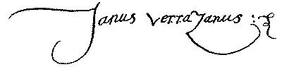
The map of Hieronimo da Verrazano is without doubt the strongest support of the letter and voyage of his brother Giovanni. That these persons were brothers appears from a document dated May 11, 1526, whereby the navigator constitutes “Jarosme de Varasenne, son frère et heritier,” his attorney to act for him during a proposed voyage to the Indies. This paper, first printed by M. Harrisse in 1876, is signed “Janus Verrazanus.” Dr. De Costa gives a fac-simile of this signature,—here reproduced,—the only known autograph of Verrazano.[90]
Mr. Brevoort gives perhaps the best description of the map, and I condense the following from his account of it. The map is on three sheets of parchment, pasted together, and is 260 centimetres long and 130 wide (about 102 inches by 51), its length being just double the width. It is well preserved, somewhat stained; but no part, except coast-names, is indistinct. Its projection is the simple cylindrical square one, in which all the degrees of latitude are made equal to each other and to the equatorial ones. Like other maps of its period, it has the equator drawn below the middle of the map, and shows 90° of latitude north, and 64° south of it. In breadth it represents about 320° of longitude. There is no graduation for longitude; but the meridians that cross the centres and sides of the two great circles of windroses appear to be drawn seventy degrees apart. There is the usual network of cross-lines radiating from windroses, with one great central rose in north latitude 16°. From the centre of each rose thirty-two lines are drawn to the points of the compass, and these lines are prolonged to the margin of the map. One meridian is divided into degrees of latitude of equal size, each one numbered. Close to the upper margin there is a small scale, with a legend explaining that from point to point there are twelve and a half leagues, each of four miles. The scale is equal to eighteen degrees of latitude in length, and is subdivided into six parts, each having four divisions or points.
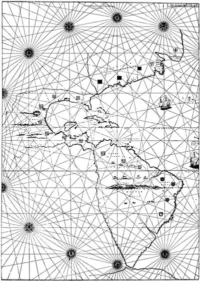
THE VERRAZANO MAP
A fac-simile of the engraving given by Brevoort, sufficient for a general outline.
Mr. Brevoort next gives a careful account of the representation of different parts of the world upon this map. Passing somewhat rapidly over the eastern hemisphere, which appears to be generally drawn from the most recent authorities, he takes up the western in some detail. The latitudes of the map are wrong; all the West India Islands are placed several degrees too high, thus forcing northward all other places. Verrazano’s landfall, for instance, is here indicated at about 42°, instead of 34°, as stated in the letter. With this correction the map shows the American coast with some approach to accuracy. Three French standards[91] are placed (according to Brevoort) on the territory claimed as Verrazano’s discovery,—one at the southern and one at the northern limit, with the third at the place where the explorers spent fifteen days. Over these three flags appears the inscription, in capital letters, “NOVA GALLIA SIVE IUCATANET,” and the legend, already cited, “VERRAZANA SIVE NOVA GALLIA,” etc.
Mr. Brevoort has industriously collected the scanty references to this map after it became the property of Cardinal Borgia, with whose collection it was bequeathed to the Propaganda in 1804; but he has been unable to discover the time when the Cardinal procured it, and the source whence it came to his collection. Nothing, indeed, is known of its early history.[92]
Dr. De Costa devotes a chapter of his book to the map of Hieronimo. After showing that the map-maker and the navigator were brothers, he proceeds to consider the genesis of the map, and finds the beginning of its North American portion in the Lorraine map, published in the Ptolemy of 1513. The latitudes of the Verrazano map are recognized as erroneous, and the observer is warned to disregard them. “When this is done, the student will have no difficulty in recognizing the outlines of the North Atlantic coast. For general correctness, the delineation is not equalled by any map of the sixteenth century.” Prominent places are identified and named.
The influence of this map upon subsequent ones is next considered, and a long list of maps showing this influence is cited. Dr. De Costa adds to the value of his discussion by giving tracings from several of these maps, with fac-similes of the Verrazano map, and an enlarged drawing of its coast-line.[93] But the strong point of his chapter, and that for which he deserves the greatest credit, is the publication of a sketch of Verrazano’s coast of the United States, with the names of places attached. These names he deciphered from the original map during a late visit to Rome. They are, of course, of the greatest value in any future study of the map. Dr. De Costa enters somewhat into a study of these names.[94]
M. Desimoni, while generally acknowledging his indebtedness to Dr. De Costa’s work, and praising that gentleman’s scholarship and research, could not accept all his inferences in the matter of the names, and doubted some of his readings. He therefore caused a fresh examination of the map to be made, through the kind and learned services of Dr. Giacomo Lumbroso and Canon Fabiani. He prints, in the Appendix to his Studio secondo on Verrazano, in parallel columns, the variations from De Costa’s readings. The great difficulty and doubt attending the deciphering words, particularly names, in old documents and maps, is well known to all who have attempted such work.[95]
A discovery made lately at Milan brings out a new map, and one of great value in the discussion of Verrazano’s voyage. M. Desimoni, on his return to Genoa from the Geographical Congress held at Venice in September, 1881, stopped at Milan, where he visited the Ambrosian Library to consult some maps. He was there told by the prefetto, the Abbé Ceriani, that a map by Vesconte Maggiolo, hitherto supposed to bear the date of 1587, and therefore to have been the work of one of the second generation of this family of map-makers, was really dated 1527. By comparing the legend on this map with one of similar form and writing on a map of 1524, it could be seen that the numeral 2 in the first map had become an 8 by lengthening the curves of the figure until they were finally joined. This appeared to have been done with ink of a paler color. M. Desimoni reproduces the two legends, to show the process.[96] He finds also certain peculiarities in the map, supposed of 1587, which prove that it must belong to the first decades of the century, and therefore entertains no doubt of the correctness of the change in the date.
Fresh from studies of early American voyages, M. Desimoni examined the North American portion of this map, particularly the coast, with as great care as his limited time and the poor condition of the parchment permitted. He was not a little surprised to find that the coast bore names closely related both to the Verrazano and to other maps whose source is yet undiscovered. He made a copy of the names, and afterward submitted his work to Signor Carlo Prayer, of Milan, who verified it, and also furnished as perfect a copy as it was possible to make of the names, and a sketch of the whole coast. This was reproduced by M. Desimoni to illustrate a paper prepared for the Società Ligure di’ Storia Patria.
This map measures about seventy-five centimetres in length by about fifty in width,—about 29½ inches by 19½. Its legend reads: “Vesconte de Maiollo conposuy hanc cartam in Janua anno d̄ny. 1527, die xx Decenbris.” The place occupied in the Verrazano map by the title Nova Gallia, etc., and the legend about Verrazano’s discovery, bears in this map the name Francesca, to indicate exactly a name for the whole region.
There is no mention of Verrazano by name in this map, but there is ample evidence of a connection between Maggiolo’s map and that of Hieronimo da Verrazano; very probably, M. Desimoni thinks, through the intervention or medium of some chart or charts yet unknown. The Maggiolo map has a reference to Florence, Verrazano’s birthplace, in the names of “Valle unbrosa” (Vallambrosa), “Careggi,” etc.; references to France and Francis in such names as “Anguileme,” “Longavilla,” “Normanvilla,” “Diepa,” “San Germano,” and others, particularly “Luisa,” applied to an island. The map is connected with Verrazano’s, not only by this name, but by a great number which the two have in common. It is true that these names are not always applied to the same positions on the two maps: “Luisa” is a squarish island on the Maggiolo map, and a triangular one on the other, and in the letter. The latitudes of Maggiolo’s map are different. Florida is placed as far south as the tropic. There is naturally some diversity in the general direction of the coast, and in the distances from place to place. But the substantial points are equivalent, if not identical. We have the Nova Gallia in its equivalent, Francesca; the same allusions in the names to Tuscany, France, Dieppe; and an identity in the names of three very important places,—“Luisa,” the port of refuge, and the attempt to show Cape Cod.
M. Desimoni examines again the map of Gastoldo, first published in the Ptolemy of 1548, inserted later in Ramusio’s third volume, and the globe known as the globe of Ulpius, already mentioned here. Both contain names that appear on the Verrazano map; but an examination shows that both contain names not on that map, and each contains at least one name not on the other. All these names are found on the map of Maggiolo; and M. Desimoni concludes his paper with a table in four parallel columns, in which a careful comparison is given of the nomenclature of four maps,—the Maggiolo of 1527, the Verrazano of 1529, the Ulpius globe of 1542, and the Gastoldo of 1548.[97]
The earliest mention of the voyage of Gomez is found in Oviedo’s Sumario, which was published at Toledo in 1526.[98] It is there stated (folio xiv, verso) that Gomez returned in November from a voyage begun the year before (1524, which we now know is an error); that he had found in the north “a greate parte of lande continuate from that which is caued Baccaleos, discoursynge towarde the West to the xl. and xli. degree [et puesta en quarenta grados y xli, et assi algo mas y algo menos], frō whense he brought certeyn Indians,” etc.[99]
Peter Martyr’s Decades were published in a complete edition at Alcala in 1530,[100] and his Letters appeared also that same year from the same press.[101] He speaks thus of Gomez in the Decades: “It is also decreed that one Stephanus Gomez, who also himselfe is a skillful navigator, shal goe another way, whereby, betweene the Baccalaos and Florida, long since our countries, he saith he will finde out a waye to Cataia: one onely shippe, called a Caruell, is furnished for him, and he shall haue no other thing in charge then to search out whether any passage to the great Chan, from out the diuers windings and vast compassings of this our Ocean, were to be founde.”[102]
And later he narrates the return of the expedition, its failure to find the strait (declaring his own opinion that Gomez’ “imaginations were vaine and frivolous”), and tells the story about the mistake of cloves and slaves.[103] In a letter written in August, 1524, he speaks also of the voyage of Gomez, but I find no mention of his return in that publication.[104]
Gomara devotes a short chapter to Gomez. He says that his purpose was to find a northern passage, but that he failed; and so, loading his ship with slaves, returned home. He also relates the clove anecdote.[105]
Herrera gives an account of Gomez and his voyage. He says: “Corriò por toda aquella costa hasta la Florida, gran trecho de Tierra lo que hasta entonces, por otros Navios Castellanos, no estaba navegado, aunque Sebastian Gaboto, Juan Verraçano, i otros lo havian navegado.... Desde la Florida, atravesò à la Isla de Cuba, i fue à dar al Puerto de Santiago, adonde se refrescò, i le regalò Andrès de Duero, por lo qual el Rei le mostrò agradecimiento, bolviò à Castilla i aportò à la Coruña diez meses despues que saliò de aquel Puerto,” etc.[106] “He ran along that whole coast as far as Florida,—a great stretch of land which, up to that time, had not been traversed by other Spanish ships, although Sebastian Cabot, John Verrazano, and others had sailed along it.... From Florida he passed to the island of Cuba, and entered the port of Santiago, where he refreshed, and Andrès de Duero regaled him, for which the King showed gratitude. He returned to Castille, and landed at Corunna ten months after he had sailed from that port,” etc.
Galvano, in his account of the voyage, appears to make Gomez sail along the American coast from south to north; while Herrera, it will have been observed, reverses this direction.[107] The testimony of Cespedes has already been considered.[108] Dr. Kohl, in his Discovery of Maine, gives a good account of Gomez’ voyage, based on careful study of the authorities.[109]
The mutinous conduct of Gomez in the fleet of Magellan is related by Pigafetta, who accompanied that expedition, and kept a diary, from which he afterward made up an account of the voyage. One of the copies of this, which existed only in manuscript, was given to Louisa, mother of Francis I. of France, who employed Jacques Antoine Fabre to translate it into French. He made in preference an abridgment of the account, and this was published at Paris in 1525.[110]
For the opinion that a northern passage through America could be discovered somewhere between Florida and the Baccalaos, Navarrete’s work may be consulted.[111] He gives among his documents the letter of the King commanding the attendance of Dornelos;[112] the agreement with Agramonte in 1511, and his commission as captain of the expedition,[113] and the grant to De Ayllon.[114] He has found also the appointment of Gomez as pilot just before the sailing of his expedition, Feb. 10, 1525.[115]
The Agreement of Gomez with the Emperor for the voyage is printed in full in the Documentos ineditos.[116] Hernando Cortes’ letter about the existence of the northern passage may be consulted in an English translation in Mr. Folsom’s Despatches of Cortes.[117]
The discoveries of Gomez are laid down upon a map[118] of the world made, at the command of the Emperor, in 1529 by Diego Ribero, a well-known cosmographer, who had been sent to the Congress of Badajos as one of the Spanish experts.
On a large section of this coast extending from Cape Breton westward about three hundred leagues to a point where the land bends to the south, is the legend: “Tierra de Estevan Gomez la qual descubrio por mandado de su magt nel anno de 1525 ay en ella muchos arboles y fructas de los de españa y muchos rodovallos y salmones y sollos: no han allado oro.” (“The Country of Stephen Gomez, which he discovered at the command of his Majesty, in the year 1525. There are here many trees and fruits similar to those in Spain, and many walruses and salmon, and fish of all sorts. Gold they have not found.”)[119] This is supposed to have been drawn from the reports of Gomez, and to contain his coast-lines and the names which he gave to places.
Oviedo wrote in 1537 a description of the American coast from a map made by Alonzo de Chaves the year before. He frequently cites Gomez as his authority for the names of places, etc. This part of Oviedo’s work remained in manuscript until its publication by the Academy of Madrid in 1852. Dr. Kohl enters into an elaborate commentary of this description by Oviedo, and the Chaves map, of which not even a copy has come down to our times.[120]
The books of André Thevet which contain the accounts of his visit to this country are the Singularitez de la France antarctique and the Cosmographie universelle.[121] Besides these works Thevet published an account of his journey to the East, Cosmographie du Levant, at Lyons, in 1554, and a series of portraits and lives of great men, ancient and modern, in two volumes, at Paris, in 1584. He left also several manuscripts, which are now preserved in the National Library at Paris.
The Singularitez passed to a second edition,[122] and was translated into Italian by Giuseppe Horologgi,[123] and into English[124] by M. Hacket. A reprint of the original edition was published at Paris in 1878, with notes, and a biographical preface by M. Paul Gaffarel of Dijon.
The Cosmographie was not reprinted, nor was it, so far as I know, translated into any other language. In the Magazine of American History for February, 1882, however, Dr. De Costa published a translation of the part of the book which relates to New England.
It seems quite probable that Thevet never made the voyage along the American coast of which he pretends to give an account. He gives nothing at all from Florida to what he calls the River of Norumbega, and is generally very indefinite in all his statements. He may easily have taken his stories from other travellers’ books, and it is known he used Cartier and others; and indeed he is said to have been ill nearly all the time of his stay in Brazil, and to have scarcely stirred out of the island where the fort was, waiting for the ship to make ready for home.
Thevet’s reputation for veracity is poor, particularly among his contemporaries. Jean de Léry, who was one of the party which went out to Villegagnon, in response to his appeal for Protestant ministers in 1556, after Thevet’s return home, wrote an account of the Brazil enterprise. This, first published at La Rochelle in 1578, passed through several editions. The preface of the second edition is occupied with an exposure of the “errors and impostures” of Thevet, and that of the fifth edition contains more matter of the same kind. De Léry calls Thevet “impudent menteur,” and speaks of his books as “vieux haillons et fripperies.” Again he says, “Il fait des contes prophanes, ridicules, pueriles, et mensonges pour tous ses escrits.” Possibly some allowance may be made for the odium theologicum of the writer, a Calvinist, disputing with a monk; and it may be remembered that both had been disappointed in any hopes they had entertained of the conversion of the Indians, through the treachery of Villegagnon.