Part 2 — CHAPTER II. (continued 2)
Reading edition
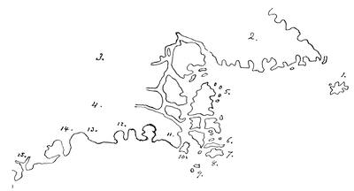
FROM GASTALDI’S MAP.
A sketch of map no. 56 in the Italian edition of Ptolemy, 1548, entitled, “Della terra nova Bacalaos.” The following key explains it: 1. Orbellande. 2. Tierra del Labrador. 3. Tierra del Bacalaos. 4. Tierra de Nurumberg. 5. C: hermoso. 6. Buena Vista. 7. C: despoir. 8. C: de ras. 9. Breston. 10. C. Breton. 11. Tierra de los broton. 12. Le Paradis. 13. Flora. 14. Angoulesme. 15. Larcadia. 16. C: de. s. maia.
Paul Forlani, of Verona, had scarcely advanced beyond this plot of Gastaldi, when so late as 1565 he published at Venice his Universale descrittione (Thomassy, Les Papes géographes, p. 118).
Harrisse[338] thinks that the praise bestowed upon Desceliers as the creator of French hydrography is undeserved, as the excellence of the maps of his time presupposes a long line of tentative, and even good, work in cartography; and he holds that Portuguese influence is apparent from the early part of the sixteenth century.
Wuttke, in his “Geschichte der Erdkunde,”[339] describes and figures several manuscript American maps from the Collection in the Palazzo Riccardi at Florence, dated 1550 or thereabout; but they add nothing to our knowledge respecting the region we are considering. One makes a large gulf in the northeast of North America, and puts “Terra di la S. Berton” on its east side, and “Ispagna Nova” on the west. This gulf has a different shape in two other of the maps, and disappears in some. In one there is a gulf prolonged to the west in the far north.
At about this date we may place a curious French map, communicated by Jomard to Kohl, and included by the latter in his Washington Collection. A sketch of it is annexed.[340] It is manuscript, and bears neither name nor date. The extreme northeastern part resembles Rotz’s map of 1542, and the explorations of Cartier and Roberval seem to be embodied. The breaking-up of Newfoundland would connect it with Gastaldi’s maps, or the information upon which Gastaldi worked, while the names on its outer coast are of Portuguese origin, with now a Spanish and now a French guise. Farther south the coast seems borrowed from the Spanish maps. The large river emptying into the St. Lawrence from the south is something unusual on maps of a date previous to Champlain. If it is the Sorel, Champlain’s discovery of the lake known by his name was nearly anticipated. If it is the Chaudière, it would seem to indicate at an early day the possibilities of the passage by the portage made famous by Arnold in 1775, and of which some inkling seems to have been had in the union of the St. Lawrence and the Gulf of Maine not infrequently shown in the early maps. The most marked feature of the map, however, is the insularity of the continent, with a connection of the Western Ocean somewhere apparently in the latitude of South Carolina, similar to that shown in John White’s map, as depicted in the preceding chapter. It may, of course, have grown out of a belief in the Sea of Verrazano; or it may have simply been a geographical gloss put upon Indian reports of great waters west of the limit of Cartier’s expedition.
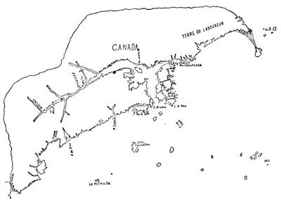
THE JOMARD MAP, 155—(?).
Harrisse[341] puts circa 1553 a fine parchment planisphere, neither signed nor dated, which is preserved in the Archives of the Marine in Paris. It shows the English standard on Labrador (Greenland), the Portuguese on Nova Scotia, and the Spanish at Florida.
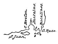
PART OF BELLERO’S MAP, 1554.
The whole map is reproduced in Vol. VIII.
Another popular American map by Bellero was used in the Antwerp Gomara of 1554, and in several other publications issuing from that city.[342] It was not more satisfactory, as the annexed sketch shows,—which indicates that even in Antwerp the full extent of Cartier’s explorations was not suspected. Nor had Baptista Agnese divined it in his atlas of the same year, preserved in the Biblioteca Marciana at Venice. Our sketch is taken from the fifth sheet as given in a photographic fac-simile[343] issued at Venice in 1881, under the editing of Professor Theodor Fischer, of Kiel.
An elaborate portolano Cosmographie universelle, par Guillaume Le Testu, and dated in 1555, is described by Harrisse[344] as an adaptation of a Portuguese atlas, with the addition of some French names. The northern regions of North America are called Francia.
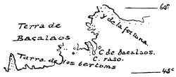
BAPTISTA AGNESE, 1554.
In 1556, in the third volume of Ramusio’s Navigationi et viaggi,[345] Gastaldi, excelling a little his Ptolemy map of 1548,—a sketch of which is given on p. 88,—produced his Terra de Labrador et Nova Francia; while for the accounts which Ramusio now printed of Cartier’s voyage, Gastaldi added the Terra de Hochelaga nella Nova Francia,—which was simply a bird’s-eye view of an Indian camp.[346]
In the same year (1556) the map of Volpellio was not less deceptive. Two years later (1558) we find an atlas in the British Museum, the work of Diego Homem, a Portuguese cartographer, which seems to indicate other information than that afforded by Cartier’s voyages. It is not so accurate as regards the St. Lawrence as earlier maps are, but shows additional knowledge of the Bay of Fundy, which comes out for the first time, and is not again so correctly drawn till we get down to Lescarbot, half a century later.
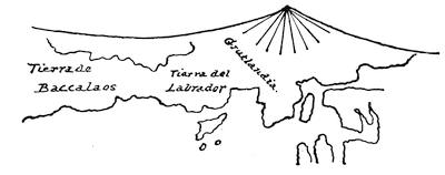
VOPELLIO.
Part of the northern portion of Vopellio’s cordiform mappemonde, which appeared in Girava’s Cosmographia, Milan, 1556; cf. Carter-Brown Catalogue, i. 200. The map is very rare; Stevens has issued a fac-simile of it from the British Museum copy.
Girolamo Ruscelli, in the Venice edition of Ptolemy, 1561, gave a map which was evidently derived from the same sources as the Gastaldi, as the annexed sketch will show.
A mere passing mention may be made of a large engraved map of America, of Spanish origin, “Auctore Diego Gutierro, Phillipi regis cosmographo,” dated 1562, because of its curious confusion of names and localities in its Canadian parts.[347]
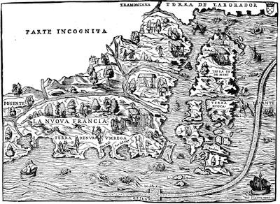
GASTALDI IN RAMUSIO.
Kohl, Discovery of Maine, p. 226 (who gives a modern rendering of this map), puts the making of it at about 1550,—two years later than the appearance of his Ptolemy map.
The atlas of Baptista Agnese of 1564, preserved in the British Museum,[348] and another of his of the same date in the Biblioteca Marciana, still retain some of the features of his earlier portolanos. He always identifies Greenland with Baccalaos, and still represents Newfoundland as a part of the main. Harrisse holds that he had not advanced beyond the Toreno (Venice) map of 1534, and in 1564 knew little more of the Newfoundland region than was known to Ribero and Chaves thirty-five years earlier.
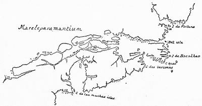
HOMEM, 1558.
This sketch follows a reproduction in Kohl’s Discovery of Maine, p. 377; cf. British Museum Catalogue of Manuscript Maps (1844), i. 27; Harrisse, Cabots, p. 243. Various atlases of Homem are preserved in Europe. This 1558 map (giving both Americas) is included in Kohl’s Collection at Washington, as well as another map of 1568, following a manuscript preserved in the Royal Library at Dresden, purporting to have been made by “Diegus Cosmographus” at Venice. Kohl thinks him the Diego Homem of the 1558 map, which the 1568 map closely resembles, though it makes the northern coast of America more perfect than in the earlier draft.
The Catalogue of the King’s maps in the British Museum puts under 1562 a map entitled, Universale descrittione di tutta la terra cognosciuta da Paulo di Forlani.
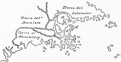
RUSCELLI, 1561.
A sketch of his Tierra Nueva. The key is as follows: 1. Lacadia. 2. Angouleme. 3. Flora. 4. Le Paradis. 5. P. Real. 6. Brisa I. 7. Tierra de los Breton. 8. C. Breton. 9. Breston. 10. C. de Ras. 11. C. de Spoir. 12. Buena Vista. 13. Monte de Trigo. 14. Das Chasteaulx. 15. Terra Nova. 16. C. Hermoso. 17. S. Juan. 18. Isola de Demoni. 19. Orbellanda. 20. Y. Verde. 21. Maida.
There are reproductions of this map in Kohl’s Discovery of Maine, p. 233, and Lelewel, Géographie du Moyen-Age, p. 170; cf. Harrisse, Cabots, p. 237; and his Notes, pour servir à l’histoire ... de la Nouvelle France, etc., no. 294.
Thomassy,[349] however, cites it as published in Venice in 1565, and says it strongly resembles Gastaldi’s map, and is, perhaps, the same one credited to Forlani under 1570, as showing the recent discoveries in Canada. It is contained in the so-called Roman atlas of Lafreri, Tavole moderne di geografia, Rome and Venice, 1554-1572.[350]
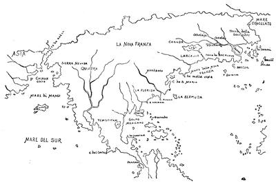
ZALTIERI, 1566.
Next in chronological order comes an engraved map (15½ × 10½) with the following title: Il disegno del discoperto della Nova Franza ... Venetijs aeneis formis Bolognini Zalterij, Anno M.D. LXVI.[351] It gives the whole breadth of the continent, and is very erroneous in the eastern parts. The “R. S. Lorenzo” runs southeast from a large lake into the ocean between Lacadia and Baccalaos, while Ochelaga and Stadaconi[352] are on a river running east farther to the north, whose headwaters are in a region called “Canada.” The island C. Berton, as well as Sable Island (Y. Darena), would seem to indicate that the coast to the north of them is intended for the modern Nova Scotia, which would make the river running from the lake the Penobscot, and the group of islands east of Baccalaos a disjointed Newfoundland, compelling the river rising near Canada to do duty for the St. Lawrence. The large island, “Gamas,” is perhaps a reminiscence of Gomez.[353] The map in these parts is so confused, however, that its chief interest is to illustrate the strange commingling of error and truth, “which we have received lately,” as the inscription reads, “from the latest explorations of the French,”—which must, if it means anything, refer to Roberval. The map has signs neither of latitude nor longitude. In general contour it resembles other Italian maps of this time, like those of Forlani, Porcacchi, etc. Zaltieri differs from Forlani, however, in separating America from Asia.
The great mappemonde of Gerard Mercator, introducing his well-known projection, followed in 1569. The annexed sketch indicates its important bearing on a portion of North American cartography. The St. Lawrence is extended much farther inland than ever before, with no signs of the Great Lakes, and it is made to rise in the southerly part of the region, put in modern maps west of the Mississippi, among mountains which also form a watershed westerly to the Gulf of California and southerly to the Gulf of Mexico.
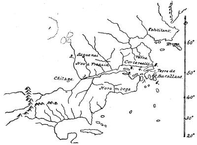
MERCATOR, 1569.
The key is as follows: 1. Hic mare est dulcium aquarum, cujus terminum ignorari Canadenses ex relatu Saguenaiesium aiunt. 2. Hoc fluvio facilior est navigatio in Saguenai. 3. Hochelaga. 4. Po de Jacques Cartier. 5. Belle ysle. 6. C. de Razo. 7. C. de Breton. 8. Y. della Assumptione. 9. G. de Chaleur.
A fac-simile of this map is given on a later page.
Kohl[354] sums up his essay on this map as follows: “It is a remarkable fact, that while the icy seas and coasts of Greenland, Labrador, Newfoundland, and Canada were depicted on the maps of the sixteenth century with a high degree of truth, our coasts of New England and New York were badly drawn so late as 1569; and their cartography remained very defective through nearly the whole of the sixteenth century.”
A close resemblance to Mercator is seen in the rendering of Ortelius in the first (1570) edition of his Theatrum orbis terrarum.[355] The contour and general details of North America, as established by Mercator and Ortelius, became a type much copied in the later years of the sixteenth century. The woodcut map in Thevet’s Cosmographie universelle (1575), for instance, is chiefly based on Ortelius, though Thevet claimed to have based it on personal observation in 1556.[356]
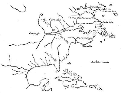
ORTELIUS, 1570.
The maps in De la Popellinière’s Les trois mondes (1582), that of Cornelius Judæus (1589), those in Maffeius’s Historiarum Indicarum libri xvi. (1593), in Magninus’s Geographia (1597), and in Münster’s Cosmographia (1598),—all follow this type. Reference may also be made to a Spanish mappemonde of 1573 which is figured in Lelewel,[357] an engraved Spanish map in the British Museum, evidently based on Ortelius, and assigned by the Museum authorities to 1600; but Kohl, who has a copy in his Washington Collection, thinks it is probably earlier. A similar westward prolongation of the St. Lawrence River is found in a “Typus orbis terrarum,” dated 1574, which, with a smaller map of similar character, appeared in the Enchiridion Philippi Gallæi, per Hugonem Favolium, Antwerp, 1585. Quite another view prevailed at the same time with other geographers, and also became a type, as seen in the map given by Porcacchi as “Mondo nuovo” in his L’ isole piu famose del mondo, published at Venice in 1572, in which he mixes geographical traits and names in a curious manner. It is not easy to trace the origin of some of this cartographer’s points.
A theory of connecting the Atlantic and the St. Lawrence on the line of what is apparently the Hudson River, which had been advanced by Ruscelli in the general map of the world in the 1561 edition of Ptolemy, was developed in 1578 by Martines in his map of the world in the British Museum, from a copy of which in the Kohl Collection the accompanied sketch is taken.[358]
What is known as Dr. Dee’s map was presented by him to Queen Elizabeth in 1580, and was made for him, if not by him. It is preserved in the British Museum, and the sketch here given follows Dr. Kohl’s copy in his Washington Collection. Dee used mainly Spanish authorities, as many of his names signify; and though he was a little too early to recognize Drake’s New Albion, he was able to depict Frobisher’s Straits.[359]
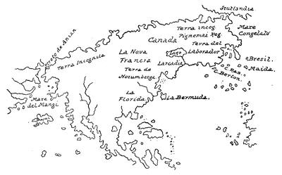
PORCACCHI, 1572.
This is sketched from the copy in the Harvard College Library. The book has a somewhat similar delineation in an elliptical mappemonde, of which a fac-simile is given in Stevens’s Historical and Geographical Notes. The bibliography of Porcacchi is examined in another volume.
The peculiarities of three engraved English maps of about this time are not easy to trace. The first map is that in Sir Humphrey Gilbert’s Discourse;[360] the second is the rude drawing which accompanied Beste’s True Discourse relating to Frobisher;[361] the third, that of Michael Lok,[362] in Hakluyt’s Divers Voyages. Hakluyt, in the map which he added to the edition of Peter Martyr published in Paris in 1587, conformed much more nearly to the latest knowledge.[363]
We find what is perhaps the latest instance of New France being made to constitute the eastern part of Asia, in the map (1587) given in Myritius’s Opusculum geographicum rarum, published at Ingoldstadt in 1590.[364] A group of small islands stands in a depression of the coast, and they are marked “Insulæ Corterealis.” It carries back the geographical views more than half a century.
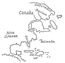
Illustration: MARTINES, 1578.
In the Molineaux globe of 1592,[365] preserved in London, we find a small rudimentary lake, which seems to be the beginning of the cartographical history of the great inland seas,—a germ expanded in his map of 1600[366] into his large “Lacke of Tadenac.” Meanwhile Peter Plancius embodied current knowledge in his well-known map of the world. So far as the St. Lawrence Valley goes, it was not much different from the type which Ortelius had established in 1570. Blundeville, in his Exercises (1622, p. 523), describing Plancius’ map, speaks of it as “lately put forth in the yeere of our Lord 1592;” but in the Dutch edition of Linschoten in 1596 it is inscribed: Orbis terrarum ... auctore Petro Plancio, 1594.
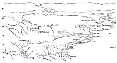
JUDÆIS, 1593.
It appeared re-engraved in the Latin Linschoten of 1599; but in this plate it is not credited to Plancius. The map which took its place in the English Linschoten, edited by Wolfe, in 1598, was the same recut Ortelius map which Hakluyt had used in his 1589 edition. This was the work of Arnoldus Florentius à Langren, though Wolfe omits the author’s name.[367]
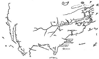
JOHN DEE, 1580.
In the map, “Americæ pars borealis, Florida, Baccalaos, Canada, Corterealis, a Cornelio de Judæis in lucem edita, 1593,” which appeared in that year in his Speculum orbis terrarum, Mercator and Ortelius seem to be the source of much of its Arctic geography; but its Lake Conibas, with its fresh water, records very likely some Indian story of the Great Lakes lying away up the Ottawa,—which is presumably the river rising in the Saguenay country. A legend on the map says that its fresh water is of an extent unknown to the Canadians, who are, as another legend says, the nations filling up the country from Baccalaos to Florida.
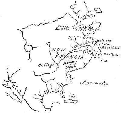
DE BRY, 1596.
It will be observed that to the northwest the Zeno map[368] has been made tributary, while one name, “Golfo quarré,” is not in the place usually given to it, since it is generally the alternative name of the Gulf of St. Lawrence. The nomenclature of the coast from Cape Breton south follows the Spanish names; and though Virginia is recognized by name, there is no indication of the new geography of that region.[369]
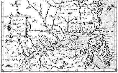
FROM WYTFLIET.
De Bry in 1596 added little that was new; and much the same may be said of the maps in the edition of Ptolemy published at Cologne in 1597, and numbered 2, 29, 34, and 35.[370]
New France is also shown in the “Nova Francia et Canada, 1597,” which is no. 18 of the series of maps in Wytfliet’s Continuation of Ptolemy. Others in the same work show contiguous regions:—
No. 15. “Conibas regio cum vicinis gentibus,”—Hudson’s Bay and the region south of it.
No. 17. “Norumbega et Virginia,”—from 37° to 47° north latitude.
No. 19. “Estotilandia et Laboratoris,”—Labrador and Greenland, mixed with the Zeni geography.
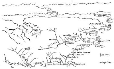
QUADUS, 1600.
The map by Mathias Quaden, or Quadus, in the Geographisches Handbuch, was published at Cologne in 1600, bearing the title, “Novi orbis pars borealis.” The northeastern parts seem to be based on Mercator and Ortelius. A marginal note at “Corterealis” defines that navigator’s explorations as extending north to the point of what is called Estotilant. In its Lake Conibas it follows the 1593 map of Judæis.
In this enumeration of the maps showing the Gulf and River St. Lawrence down to the close of the seventeenth century, by no means all of the reduplications have been mentioned; but enough has been indicated to trace the somewhat unstable development of hydrographical knowledge in this part of North America. Most interesting, among the maps of the latter part of the century which have been omitted, are, perhaps, the Erdglobus of Philip Apian (1576), given in Wieser, Magalhâes-Strasse, p. 72; the mappemonde in Cellarius’ Speculum orbis terrarum (Antwerp, 1578); the map of the world in Apian’s Cosmographie augmentée, par Gemma Frison (Antwerp, 1581, 1584, and the Dutch edition of 1598); the map of the world by A. Millo (1582), as noted in the British Museum Manuscripts, no. 27,470; that in the Relationi universali di Giovanni Botero, Venice (1595, 1597, 1598, 1603); the earliest English copperplate map in Broughton’s Concent of Scripture (1596); the Caert-Thresoor of Langennes, Amsterdam, 1598; and, in addition, the early editions of the atlases of Mercator, Hondius, Jannsen, and Conrad Loew, with the globes of Blaeuw.
The maps in Langenes were engraved by Kærius, and they were repeated in the French editions of 1602 and 1610 (?). They were also reproduced in the Tabularum geographicarum contractarum libri of Bertius, Amsterdam, 1606, whose text was used, with the same maps, in Langenes’ Handboek van alle landen, edited by Viverius, published at Amsterdam in 1609. In 1618 a French edition of Bertius was issued by Hondius at Amsterdam with an entirely new set of maps, including a general map of America and one of “Nova Francia et Virginia.”