THE STORY OF LEWIS AND CLARK
Reading edition
In the seventeenth century it appeared likely that France would before long control the northern and interior portion of North America. La Salle discovered the Ohio River, traversed the Great Lakes, and descended the Mississippi River to its mouth. In 1742 other French explorers pushed west from the Great Lakes and sighted the Rocky Mountains. But when the English triumphed at Quebec, France gave up to them all of her possessions east of the Mississippi River, and ceded the province of Louisiana to the Spanish. This province was very much larger than the state which now bears the name. Bounded by the Mississippi River upon the east, and the Spanish possessions upon the southwest, it stretched north and west with very indefinite boundaries, although in the latter direction it was supposed to be limited by the Rocky Mountains.
At one time Napoleon dreamed of founding a great colony in America, and induced Spain to cede Louisiana back to the French; but being unable to carry out his plans, he made a proposition to the United States to take this territory. His offer was accepted, and in 1803, during the presidency of Thomas Jefferson, the vast province was taken into the Union.
It was immediately evident that more definite knowledge should be acquired concerning the great region beyond the Mississippi, particularly the portion about the head of the Missouri River. The unknown region lying between the source of this river and the Pacific should also be explored, for Captain Gray's discovery of the Columbia River gave to the United States a claim upon this part of the continent which must be maintained. If something were not done soon, the territory would be occupied by the English fur companies.
Two young men, Captains Lewis and Clark, were chosen to lead an expedition into the Northwest, which proved to be one of the most remarkable in the history of our country. They were the first white men to cross the Rocky Mountains and to traverse the continent from the Atlantic to the Pacific within the present boundaries of the United States.
How interesting it must have been to push into the Rocky Mountains, beyond the farthest point previously reached by white men; to see Nature in her wild state, to note the new plants and animals, and to study the Indians before their contact with Europeans had changed their customs!
Lewis and Clark were particularly instructed to investigate the sources of the Missouri, to learn how the continental divide could be crossed, and to ascertain the nature of the streams which flowed westward to the Pacific. They were also to study the resources of the country, and to examine into the character and customs of all the Indian tribes that they should meet.
The start was made from St. Louis in May, 1804, with two large rowboats and one sail-boat. The latter was to return with news of the party when the farthest outpost upon the Missouri was reached.
Through the summer months and late into the fall the boats toiled up the river against the swift current, finally reaching a village of the Mandan Indians in the present state of North Dakota, where the explorers spent the winter. Thus far they were in a region frequently visited by the traders and trappers from St. Louis.
FIG. 67.—THE GREAT FALLS OF THE MISSOURI
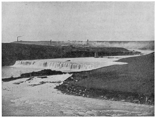
In the spring they pushed on again in canoes, at length entering an unknown region. The Missouri forked so frequently that it was often difficult to determine which was the main stream. To the surprise of the travellers, the country appeared to be uninhabited, so that they could get no assistance from the Indians. Only a small stock of provisions remained, and as the party numbered about thirty, it was necessary to keep hunters out in advance all the time.
As we are carried swiftly through this region to-day in the cars, no signs of wild creatures are to be seen, and it is difficult for us to believe that game was once abundant. The narrative of the expedition abounds with descriptions of various large animals which the explorers met in herds, such as deer, antelope, buffalo, bears, and wolves. The bears, both white and brown, were very numerous and bold. The white bears in particular were so ferocious that the hunters had many serious encounters with them. They would sometimes enter the camp at night, and at one time a herd of buffalo stampeded through it.
When undecided at one point which branch of the river to follow, Captain Lewis went some distance in advance and discovered the Great Falls of the Missouri. He was greatly impressed and awed by the magnitude and height of the successive falls, which were twenty-four, forty-seven, and eighty feet high respectively, and were connected by a series of cascades.
Many days were spent there in a long and laborious portage, for everything had to be carried a distance of twelve miles before the quiet water above the falls was reached.
How the coming of the white man has changed the region about the falls! The game has disappeared; an important city, supported by the enormous water-power, is growing up; while the smoke rising from extensive plants for reducing the gold, silver, and copper ores mined in the Rocky Mountains floats out over the country.
Proceeding up the river, the party reached the Gate of the Mountains—a picturesque spot where the stream leaves the mountains through a narrow defile between high and jagged cliffs and enters upon its long course across the Great Plains (Fig. 68). Gradually the river became smaller, and at last the travellers came to the point where it divided into three branches, to which they gave the names of Gallatin, Madison, and Jefferson forks. The party made their way up the latter fork, which flowed from a westerly direction.
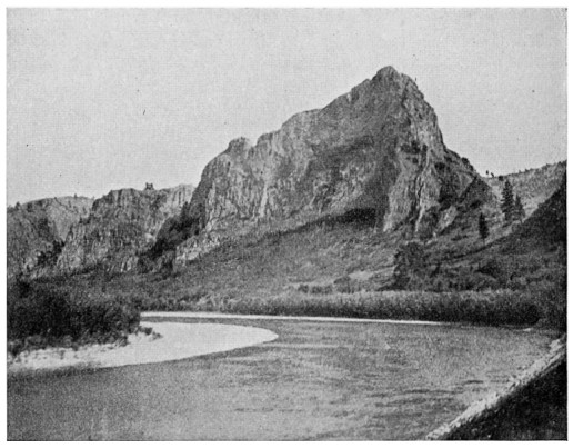
FIG. 68.—THE GATE OF THE MOUNTAINS
The Missouri River at the entrance to the Rocky Mountains
Now they began to look anxiously for the Indians, from whom it would be necessary to get horses to transport their baggage when the river should become too small for the canoes. This region was inhabited by the Shoshones. It may well be asked how it happened that these Indians had horses, since no white people had ever visited them before. Their purchase of horses came about through the processes of trade with the tribes to the south, who in turn came in contact with the Spanish of New Mexico.
One or the other of the leaders kept in advance, on the lookout for the Indians. At last Captain Lewis, while crossing the divide at the head of the stream which they had been following, came suddenly upon several Indians. After overcoming their fear by presents, he accompanied them to their camp and induced them to return with horses to assist the party.
Upon reaching the Pacific side of the continental divide the explorers were in doubt as to which way to proceed. No man had been before them, and the Indians told stories of fearful deserts to the southwest (probably the Snake River plains), and said that the mountains were too steep for the horses, and the rivers too rapid for canoes.
If you will examine a map of the country about the head of the Jefferson fork of the Missouri, you will not wonder that Captains Lewis and Clark were in doubt as to which way they should go in order to reach the Columbia. They first attempted to go down the Salmon River, but soon gave up this project. They turned about and crossed the mountains to the Bitter Root River, which flows north and empties into Lake Pend d'Oreille through Clark's Fork of the Columbia.
After going down the Bitter Root for a short distance they turned west again across the Bitter Root Mountains and came out upon the head waters of the Kooskooskie River. Unable to follow its cañons, they wandered to the north among the mountains. At this time their sufferings were intense. Food became so scarce that they were obliged to eat their horses. After many weary days they again reached the stream, but this time at a point where it was navigable. They floated down to its junction with the Lewis or Snake River, where the growing city of Lewiston now stands. At this point they met the Nez Percés Indians, who assisted them in every possible way.
FIG. 69.—CELILO FALLS, COLUMBIA RIVER
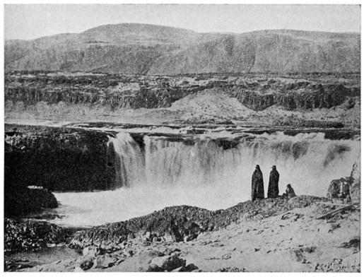
The party continued down the Snake River in canoes until they finally reached the Columbia. The difficulties of navigation were great, for at intervals of every few miles the river was broken by rapids through which it was dangerous to take the canoes. By treating the Indians kindly, the party succeeded in trading with them for such articles of food as horses and dogs. They also obtained some salmon. The presence of this fish in the streams gave them the first assurance that the Pacific slope had been reached. Along the Columbia River salmon was one of the chief articles of food for the Indians.
At Celilo Falls, a short distance above the present city of The Dalles, the travellers found great difficulty in proceeding, as the canoes and loads had to be carried, or "portaged," around the falls. Lewis and Clark called these the Great Falls of the Columbia (Fig. 69).
As the canoes floated down through the magnificent cañon by which the Columbia passes the Cascade Range, they encountered another rapid, now known as the Cascades of the Columbia. This rapid is due to a great landslide which has formed a dam across the river. Captain Lewis speaks of the broken trunks of trees rising from the water above the dam, a fact which would lead one to suppose that it had not been very long since the slide occurred.
Below the Cascades the party soon began to notice the influence of the tides in the rise and fall of the river, and knew then that the Pacific could not be very far away. Early in November they came in sight of the ocean, and in a few days had the pleasure of standing upon its shores. The long and dangerous trip of four thousand miles had been completed without any serious accident.
Continual rains poured upon them, and before winter quarters could be prepared they were in a very uncomfortable position. A permanent camp was selected upon the Oregon side of the Columbia, and log buildings were erected. The camp was called Fort Clatsop. While in their winter quarters the party cultivated friendly relations with the Indians, and made extensive notes upon their habits and characteristics.
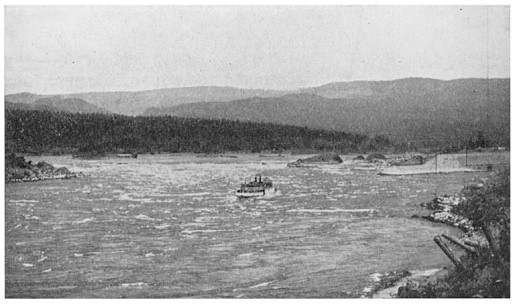
FIG. 70.—THE CASCADES OF THE COLUMBIA
A steamer going up to the locks
In the spring, since no ship had appeared which would carry them back by water, Lewis and Clark determined to return overland. First, however, they left some records with the Indians, with directions that these should be given to the captain of any ship which might happen to visit the mouth of the Columbia. The leaders wished to make sure that if anything happened to the party the knowledge gained by their explorations should not be lost.
One can imagine with what pleasure the men turned homeward. Although they had started with flour, rice, corn, and other articles of food, these had given out long before they reached the lower Columbia, and for some months their only diet had been fish and the animals that the hunters had killed. Their stock for trading with the Indians was also nearly gone; all the articles that were left could be put into two pocket handkerchiefs.
After ascending the Columbia River to a point above The Dalles, the party left the stream, as they found that it would be impossible to make much headway with the canoes. Obtaining horses from the Indians, they followed the outward route back as far as the Kooskooskie River. Then they turned north and crossed the mountains to the Missoula River. Near the present city of Missoula the party divided, Captain Lewis going up Hell Gate River and crossing the continental divide to examine the country lying north of the Missouri.
Captain Clark, with another portion of the company, went up the Bitter Root River and over the mountains to the Jefferson Fork, which the whole party had ascended the year before. He followed this river down to its junction with the Gallatin, and travelled for a distance up the latter stream, then crossed by land to the Yellowstone River.
Canoes were constructed upon the Yellowstone, and the party floated down to the junction of this river with the Missouri. There the two bands were fortunately reunited, and together they passed rapidly down the Missouri until they reached the "village" of St. Louis, where the whole population came out to welcome them. As the party had been gone more than two years, it was feared that they would never be heard from again.
There can be no doubt that the expedition of Lewis and Clark added greatly to the public interest in the vast region which they traversed, and helped to bring about the final retention of the Oregon country. The Hudson Bay Fur Company soon after established trading posts at various points along the Columbia, and kept up their contention that all the country lying north of the river rightfully belonged to England.
It was very remarkable that the Lewis and Clark expedition had made the long journey to the Pacific and back without meeting with serious accident. There were perils to be met on account of the ruggedness of the country, the rapids in the streams, the lack of food, and the danger of attack from the Indians. The successful accomplishment of the plan was without a doubt largely due to the ability of the two brave leaders.