THE GREAT BASIN AND ITS PECULIAR LAKES
Reading edition
As our country was slowly being explored and settled, one region was brought to light which Nature seemed to have left unfinished and in a desolate condition. This barren stretch of country was once marked upon the maps as the Great American Desert, and included a large part of the extensive region lying between the Rocky Mountains upon the east and the Sierra Nevada Mountains upon the west. To the south lay the Grand Cañon of the Colorado, while upon the north the boundary was formed by the cañons of the Snake and Columbia rivers.
After a time it was found that this region, covering about two hundred and twenty-five thousand square miles, not only was extremely dry, but had no outlet to the ocean. A rim of higher land all about made of it so perfect a basin that it became known as the Great Basin. None of the water that falls upon the surface of this basin ever reaches the ocean through surface streams. Some of it soaks into the rocks, but the greater part is evaporated into the dry air.
We have already learned something about the way in which the ridges and hollows of the earth's surface are made. We have learned of the wrinkling of the crust, of the formation of fissures, and of the erosive work of running water. The interesting features of the Great Basin are mainly the result of two causes: the sinking of a portion of the earth's surface, and the lack of rainfall.
Long ago the Wasatch Range of eastern Utah and the Sierra Nevadas of California formed parts of a vast elevated plateau. Then there came a time when the forces holding up the plateau were relaxed, and as the weight of the plateau pressed it down, the solid rocks broke into huge fragments. Some of the blocks thus made sank and formed valleys; others were tilted or pushed up and formed mountains. Thus the north and south mountain ranges and valleys of the Great Basin were born.
We must understand, then, that the Great Basin is not a simple depression with higher land all about. The breaking up of the surface produced many basins, large and small. Some of these basins are six thousand feet above the level of the sea, others are much lower, and one has been dropped below the level of the sea, so that if it were not for barriers the water would flow in. Some of the basins are rimmed all about by steep mountains, others are so broad and flat that it is difficult to tell that they really are basins. Many of the valleys are so connected with one another that if a heavy rainfall should ever occur drainage systems would be quickly established.
The Great Basin now appears like the skeleton of a dried-up world; but if the climate should change and become like that of the Mississippi Valley, the surface of the desert would undergo a wondrous transformation. The hundreds of basins, if fed by streams from the surrounding mountains, would then become lakes. The highest, overflowing, would empty into a lower, and this in turn into a still lower basin, until the water had accumulated in vast inland seas. These seas, overflowing the rim of the Great Basin at its lowest points, would send rivers hastening away to the ocean.
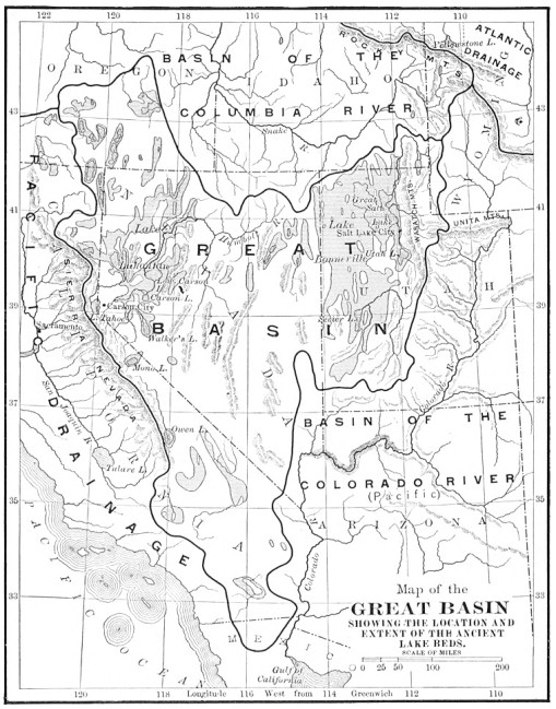
What a region of lakes this would be for a time! Then they would begin to disappear, for lakes are short-lived as compared with mountains. Some would be filled with clay and gravel brought by the streams. Others would be drained by a cutting down of their outlets.
Great Salt Lake, which is the only body of water in the Basin that has ever sent a stream to the ocean, was lowered four hundred feet by the washing away of the rock and earth at its outlet.
We know that the rainfall never has been heavy in this region since the Great Basin was formed, although at one time it was sufficiently great to form two inland seas, one in northwestern Nevada, the other in Utah.
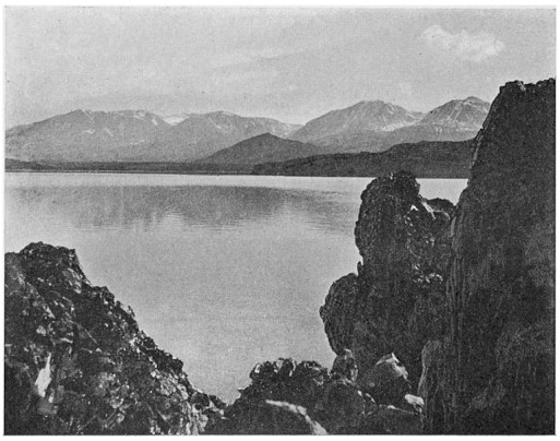
The chief reason for the dryness of the Great Basin is the presence of that lofty barrier, the Sierra Nevada mountain range, between the Basin and the Pacific Ocean. The storms, which usually come from the ocean, are intercepted by this range, and the greater portion of their moisture is taken away. The little moisture that remains falls upon the highlands of the Great Basin, and so relieves its surface from utter barrenness. The adjacent slopes of the Sierra Nevada and Wasatch ranges furnish numerous perennial streams which feed the lakes about the borders of the Basin, such as Great Salt Lake, Pyramid, Walker, Mono, Honey, and Owens lakes. The wet weather streams, flowing down the desert mountains for a short time each year, frequently form broad, shallow lakes which disappear with the coming of the summer sun.
The climate of the Great Basin has changed from time to time. During one period it was much drier than it is now, and the lakes were nearly or quite dried up. It must have been a desolate region then, shunned by animals and forbidden to man.
During the Glacial period, a few thousand years ago, the climate was moister and cooler than it is now. The mountains were covered with deep snows, and glaciers crept down the slopes of the higher peaks. Great Salt Lake covered all northwestern Utah; to this former body of water the name Bonneville has been given, in honor of a noted trapper. Pyramid, Winnemucca, Carson, Walker, and Honey lakes, now separated from one another by sagebrush deserts, were then united in one great lake, to which the name Lahontan has been given, in honor of an early French explorer.
FIG. 42.—MONO LAKE, CALIFORNIA
Lake Lahontan covered a large portion of northwestern Nevada and penetrated into California. It was broken into long winding arms and bays by various mountain ranges. The deepest portion of this ancient lake is now occupied by Pyramid Lake, which is, perhaps, the most picturesque of all the Basin lakes. Fish can live in the waters of this lake, although nearly all the others are so salty or so alkaline that they support none of the ordinary forms of life.
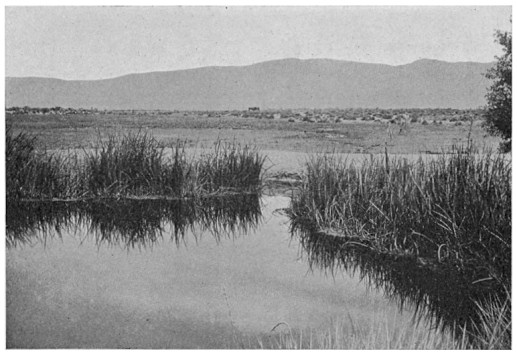
FIG. 43.—ROUND HOLE, A SPRING IN THE SMOKE CREEK DESERT
Bed of old Lake Lahontan
Upon the Black Rock Desert, in northern Nevada, there are large springs once covered by Lake Lahontan, in which fish are found. It is thought that the ancestors of these fish must have been left there at the time of the drying up of the water.
After the Glacial period the present arid climate began to prevail in the land. Hundreds of the shallow lakes which had been scattered over this extensive region disappeared. Others contained water for only a portion of each year. A body of water which is not permanent, but comes and goes with the seasons, we call a playa lake. Many of these playa lakes present in summer a hard, yellow-clay floor of many miles in extent and entirely free from vegetation. The beds of others are covered with a whitish crust, formed of the various salts which were in solution in the lake water.
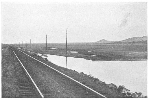
FIG. 44.—ROGERS LAKE, MOHAVE DESERT
A playa lake
An important feature of the lakes of the Great Basin is the presence of large quantities of such substances as common salt, soda, borax, and nitre. The ocean is salt because it has no outlet, while the rivers of the globe are continually bringing into it various minerals, dissolved from the rocks over which they flow. Lakes with outlets are not salty, because with a continuous change of the water there is no opportunity for the minerals to accumulate, although they are always present in small quantities. Any lake which does not receive enough running water to cause it to overflow the borders of its basin, will in course of time become rich in various kinds of salt.
No two of the lakes of the Great Basin are alike in the composition of their waters. This fact may be due to a difference in the rocks about the lake basin, to the presence of varying mineral springs, or to the drying up of one or more of the lakes at some time so that their former salts were buried under sands and clays when the water again filled the basin.
Great Salt Lake contains little besides common salt. In Mono Lake, soda and salt are equally important constituents, while Owens Lake contains an excess of soda. In other basins borax was present in such quantities that when the waters dried up it formed important deposits. The value of these deposits is now fully understood, and many enterprising companies are at work separating and purifying the borax.
Owens Lake was once fresh, although now it is so strong with soda that it would destroy the skin if a bather should remain in it very long. The former outlet of this lake was toward the south, through a pass separating the Sierra Nevada from the Coso Mountains. For a distance of thirty miles the old river-bed has been transformed into a wagon road, and it is interesting to ride all day along the bed of this dead river, past bold cliffs against which the waters once surged and foamed. The river emptied far to the south, into a broad, shallow lake whose former bed is now white with soda and borax. The old beach lines stand out distinctly upon the slopes of the enclosing mountains.
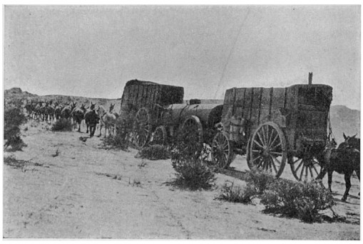
The lake bed is now the seat of an important industry—the gathering of the borax and its refining. There are extensive buildings at one spot upon its border, and men come and go across the blinding white surface. A twenty-mule team dragging three huge wagons creeps slowly along the base of the distant mountains, but all that can be distinguished is a cloud of dust.
FIG. 45.—FREIGHTING BORAX ACROSS THE DESERT
The slow crumbling of the rocks, and the setting free of those constituents which are soluble, the work of the streams in gathering the rock waste into the lakes, the dry air and the heat of the long summer days, have all conspired together to give us these valuable deposits in the dried-up lakes of the Great Basin.
No portion of the earth seems to be without value to man. The great bodies of water are convenient highways. The rich valleys and timbered mountains offer useful products. Even the deserts, where living things of every description find the struggle for existence very hard, become indispensable. If the climate in the Great Basin had been moist, the salts would not have been preserved, but would have been carried away to the ocean, from which only common salt could have been recovered in commercial quantities.
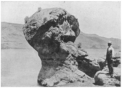
FIG. 46.—MUSHROOM ROCK, PYRAMID LAKE
Formed of calcareous tufa
The crossing of the Great Basin was dreaded by the early emigrants on their way to the Pacific coast. In many cases the locations of the few springs and water-courses were unknown, and the journey over the vast barren stretches was fraught with danger.
Stand upon a mountain in the desert some clear day in summer and you will see range after range, with intervening sandy wastes, stretching away to the horizon. The air below is tremulous with heat, and every living thing that can move has sought the shade of some rock or cliff. The plants seem almost dead, for the little springs, hidden at rare intervals in the deep cañons, are of no use to them.
What transformations would be wrought upon these desert slopes if it were possible for the soil to receive and retain large quantities of water! Forest-covered mountains, green hillsides, rippling streams, lakes, farms, orchards, and towns would appear as if by magic.