THE CLIMATE OF THE PACIFIC SLOPE
Reading edition
The western portion of the United States exhibits very interesting climatic features. In California, for example, there may be found every degree of temperature between tropic heat and arctic cold. In the deserts of the southeastern portion of the state the air is extremely dry, while in the northwest it rains nearly every month in the year.
Upon the borders of Puget Sound the thermometer seldom falls below the freezing-point, while southern Newfoundland, in the same latitude, is marked by cold and snowy weather for at least six months of every year. Southern California has the same latitude as central Georgia, but its average temperature near the coast is but little higher than that of Puget Sound, while it is warmer in winter and cooler in summer than Georgia. The deserts of southern California and Arizona are so hot that for four months of the year work in the sun is almost impossible; yet the higher portions of the Sierra Nevada mountains, but a short distance away, have an arctic climate. The whole Pacific coast region has, with the exception of the mountains, a much milder climate than one would expect from a mere knowledge of its latitude. It will be instructive to search out the reasons for the remarkable contrasts in climate presented by different portions of the slope.
The imaginary lines passing through points of equal temperature upon the earth are called "isotherms." These lines rarely accord in direction with the parallels of latitude, but curve far to the north or south. The irregular course of the isotherms is due to many causes. Among these are the distribution of the land and water, the direction of the prevailing wind, the position of the mountain ranges, and the elevation above sea-level.
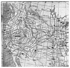
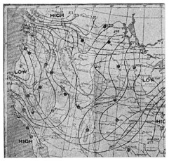
Fair weather over central portion of Pacific slope. Storm coming in upon coast of Washington Stormy weather over the western half of the United States
In winter the isotherms curve far to the north over the North Pacific and North Atlantic oceans; but over the intervening land they curve as much to the south. In summer the isotherms are almost reversed in position, at least as far as the land is concerned, for they bend to the north in the heart of the continent. There are important reasons for the slight variation of the isothermal lines upon the western borders of North America and Europe, and their great change of position in the interior from winter to summer, but these reasons are not at all difficult to understand.
The temperature of large bodies of water changes but little throughout the year, for water warms and cools slowly. The surface of the land, on the contrary, heats rapidly, and then as quickly loses its heat with the changing season. The air over the ocean is cooler in summer and warmer in winter because of the influence of the water, but over the land, in districts far from a large body of water, the changes in temperature between day and night, summer and winter, are very great.
It was formerly thought that the warm Japan current, which flows against the western shore of North America, was responsible for the exceptionally mild climate there, and that the Gulf Stream produced a similar climate upon the coast of western Europe. More careful study, however, has shown that not the warm ocean currents, but rather the winds blowing from the water, are the cause of the mild climate in those lands across which they blow. In temperate latitudes there is a slow movement of the air in an easterly direction, and in consequence the climate of the western coast of North America is not marked by such extremes in winter and summer as are the interior and the eastern sections. It is also surprising to find how nearly alike the average winter and summer temperature is at San Francisco. It is also surprising to note that the average temperature of Seattle differs so little from that of San Diego, although these two places are separated by sixteen degrees of latitude.
In some places the climatic conditions which we should naturally expect seem to be reversed. Oranges are grown in the Great Valley of California as far north as Red Bluff, and actually ripen a month sooner than they do near Los Angeles, five hundred miles farther south. The early ripening of fruits in the Great Valley may be explained by the presence of the inclosing mountain ranges: the Sierra Nevada mountains upon the northeast shut off the cold winds of winter, while the Coast ranges upon the west break the cool summer winds which come from off the Pacific.
Another interesting fact connected with the climate of the West is the influence exerted by the direction of the mountain ranges. As these ranges usually lie across the path of the prevailing winds, their tempering influence is lost much more quickly than it otherwise would be. West of the Coast ranges the summers are cool and the winters are warm. Upon the eastern side of these mountains the winters are somewhat cooler and the summers very much warmer. In the dry, clear air of the desert valleys, far from the ocean, the daily range in temperature is sometimes as great as fifty degrees, while the winters are cool and the summers unbearably hot.
We all know how much cooler a hill-top is than a valley upon a summer day. Where the mountains rise abruptly to a great height, as, for example, does the San Bernardino Range of southern California, one can stand among stunted plants of an arctic climate and look down upon orange orchards where frost rarely forms. Mount Tamalpais, a peak of the Coast Range north of San Francisco, has an elevation of nearly three thousand feet. The summer temperature upon this mountain forms an exception to the general rule, for while the lowlands are buried in chilling fog, the air upon the summit is warm and pleasant.
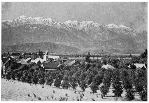
FIG. 111.—ORANGE ORCHARDS CLOSE UNDER SNOW-CAPPED PEAKS
Highlands, California
The north and south mountain ranges not only make the interior hotter than it would otherwise be, but rob it of much of the moisture which it should receive. The winter storms coming in from the ocean find the cool mountains lying across their path and quickly part with a large proportion of their moisture. Where the coast mountains are low, as is the case with a great part of California and of Oregon, more of the moisture passes on to the next line of mountains, the Sierra Nevada-Cascade Range, the western slope of which is well watered. In the region of the Columbia the Cascade Range is also low, and the storms, which often follow one another in quick succession, sweep across the Columbia plateau and over the Rocky Mountains. Farther south, not only are the storms fewer in number, but the mountains are very much higher, so that the desert basins of the lower Colorado and Death Valley region are extremely dry. One can in imagination stand upon the summit of the Sierra Nevada mountains, and upon the one hand look down upon barren valleys of vast extent, broken by mountains almost as barren, where nothing can be grown except by means of irrigation; and upon the other side, toward the coast, see a country plentifully visited by rain, and either covered with forests or given over to farming and fruit-raising.
The Rocky Mountains form the eastern barrier which the storms encounter. Their summits are very high and are covered with deep snow during the winter. East of these mountains lie the Great Plains, where the precipitation is light until we go far enough toward the Mississippi Valley to reach the influence of the moist air currents from the Gulf of Mexico. Many storms originate over the region of the Gulf of California, particularly in the late summer, and supplement to some extent the light winter storms of Arizona and New Mexico.
The storms of which we have been speaking are known as cyclones. This term does not refer to the local storms which occur in the Mississippi Valley and are frequently so destructive, but to great disturbances of the air. Sometimes the column of whirling air is more than a thousand miles in diameter. The air in a cyclone is circling and at the same time rising, so that the motion is spiral. If you will study an eddy in a stream of water, you will get an idea of the nature of the motion, except that in the case of the water eddy the movement is downward. The motion of the particles in the dust-whirls which all have seen moving across the fields near noon on warm summer days illustrate the movement of the air in one of these great storms. The direction of the air in a cyclone is opposite to that of the hands of a clock.
When the wind comes up from a southerly point, when high, thin clouds, gradually growing thicken, spread over the sky, and the barometer begins to fall, then it is known that a storm is corning. If one will learn to watch the clouds and the winds carefully he may become able to predict a storm with almost as much certainty as if he had a barometer. This instrument registers the pressure of the air, which is always less within the area of a storm, because then the air is rising. So when the barometer falls we may always know that a storm is approaching.
The greater number of the storms which occur in the central and northern United States come in from the Pacific Ocean in the latitude of Washington. Continuing east or southeast they reach the Mississippi Valley, and then turn northeastward toward the St. Lawrence Valley. In the summer months there are few storms, and they very rarely reach as far south as California. As winter approaches the storms become more frequent and severe, and move farther and farther south until the whole land as far as Mexico receives a wetting.
Upon the Pacific coast there is often very little warning of the coming of a storm, but in the Middle and Eastern States they may frequently be predicted several days in advance. With the passing of one of these storms the temperature falls rapidly, and this lowering of temperature, together with the fierce wind, gives rise upon the Great Plains to "blizzards" or "northers." These storms endanger the lives of both men and animals.
At different times in the year, particularly in winter, spring, and early summer, warm, dry winds occur. Those winds which sweep down from the heights of the Rocky Mountains and quickly melt the snows are known as "chinooks." The hot north and east winds of California often do great damage to growing crops.
Now let us sum up briefly the factors which have together produced the climatic features of the Pacific slope.
(1) Ordinarily the factor of the greatest importance is latitude. We should expect that Seattle would have a much colder climate than San Diego because it receives the sun's rays more slantingly.
(2) The influence of latitude is greatly modified by the temperate winds blowing from the Pacific, so that places far separated in latitude differ but little in average temperature, their summers being cooler and their winters warmer than we should expect them to be.
(3) The storms pass over the land with the general easterly movement of the air. The largest number pass east across the northern portion of the United States. The farther south we go the fewer are the storms and the less the rainfall. Along the coast of Washington the annual rainfall is nearly one hundred inches. At San Diego it is only about ten inches.
(4) The position of the mountain ranges causes the influence of the ocean on the air to be lost within a short distance toward the interior of the continent, so that the extremes of temperature rapidly become greater. The position of the mountains also affects the rainfall of the interior. Since a large proportion of the moisture is condensed upon their ocean slopes, the climate of each succeeding range toward the interior becomes more dry and desert-like. While in some of the lowlands thus cut off from the ocean the climate is extremely arid, yet the country is relieved from utter barrenness through the presence of mountain peaks and ranges, which often condense considerable moisture.
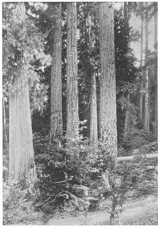
FIG. 112.—SCENE IN FORESTS OF WASHINGTON
Showing spruce and cedar
(5) The higher a region is above the sea, the colder the climate. The summit of a high mountain and the valley at its base may be in the same latitude, and yet one may possess an arctic climate while the other has a sub-tropical one.
The heavy rainfall in western Washington, Oregon, and northern California results in dense forests. To the south, the rainfall upon the lowlands is not sufficient to produce forests, but as it is greater upon the mountains, trees thrive upon their sides. The elevation at which trees will grow becomes higher and higher as we go into the more desert regions, until in northern Arizona it is found to be above six thousand feet. The high plateaus are generally treeless, but are covered with such shrubs as greasewood and sage-brush.
We see now that our climate is the product of many factors. It frequently varies greatly in places only a few miles distant from each other. Consequently there may be a great variety of productions and industries in one small area, while in other regions the climate and productions are almost unchanged for hundreds of miles.