THE HISTORY OF A COAST LINE
Reading edition
The story of our Pacific coast reads more like a tale from the "Arabian Nights" than like a plain statement of events which have actually happened.
The meeting place of the land and ocean is not really so permanent a line as it appears. The shore has been continually moving back and forth throughout the long history of the earth. That which was dry land at one time was at another time deeply buried beneath the ocean. The Pacific border seems never to have been at rest. It has risen and sunk again repeatedly. It has been squeezed, folded, and broken, shaken by earthquakes, and disturbed by volcanic eruptions.
One might be led to think from this statement that it would not be safe to live on the Pacific coast, and that both animals and men would shun the region. The fact is, however, that these changes usually come to pass so very slowly that we are not aware of them. Severe earthquakes and volcanic disturbances take place so rarely in comparison with the length of a man's life, that we may pass our whole lives without experiencing any of these violent disturbances. The Pacific coast region, with its forest-covered mountains, fertile valleys, and beautiful homes, presents so quiet and peaceful an appearance that it is difficult to believe that parts of its history have been so tumultuous.
Perhaps you will ask how we can know so much about the past. It is true that no one was here to witness the events which are supposed to have taken place. But Nature has left a record of her doings which we have only to see and understand in order to learn with certainty many things which happened in the far distant past.
Too many of us go through life seeing and understanding almost as little of the world about us as if we were blind. Our early ancestors were obliged to understand many things about Nature and to cultivate clear and close observation for the sake of self-preservation. The very life of the savage depends upon the training of his eyes. He must be able to tell the meaning of a distant object or an indistinct trail, for his enemies may have passed that way recently. If we could bring the sharp eyes of the savage to our aid, the world would mean much more to us.
In order to learn something of the history of the Pacific shore line, we must see what the waves are doing at the present time. The projecting points of land are being worn away (Fig. 33). The waves form the cliffs against which they beat, and sometimes, as they eat their way slowly into the land, they cut off portions and leave them standing alone as islands.
The pebbles and boulders (Fig. 34) were once angular fragments torn from the cliff. They have been washed about and hurled against the solid rock until they have been worn smooth; and the cliff in turn has had a cave ground out at its base. Above the lower cave there is a remnant of a second one, with pebbles upon its floor. This was made when the land stood ten feet lower than at present.
As the waves wear away the loose earth and the solid rock below it, moving the cliffs inland, they leave a comparatively smooth surface which is partly exposed at low tide. The fact that this surface is not marked by stream channels, as is the land, helps us to realize the great difference between the irregular surface of the latter and the plain-like character of the ocean floor.
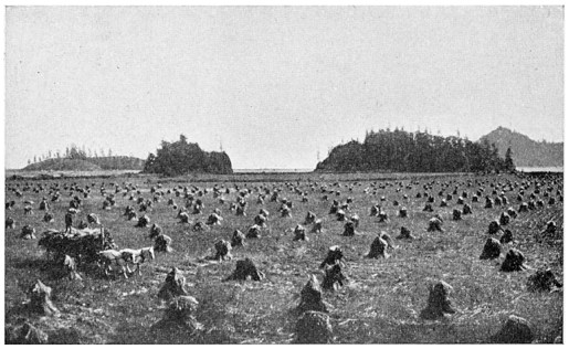
FIG. 33.—POINT BUCHON, CALIFORNIA
The waves are eating their way into the land
Along the whole coast of California there are many old sea beaches and cliffs which the waves abandoned long ago. The highest of these beaches lies so far up the slopes of the mountains bordering the ocean that it makes us wonder what the geography of California could have been like when the region was so deeply submerged.
The lowest and newest terrace is the one shown in Fig. 35, ten feet above the ocean. Each succeeding terrace is less distinct, and the highest, fourteen hundred feet in elevation, can now be distinguished in only a few places. Where the old sea cliffs are best preserved they form a series of broad, flat steps, rising one above the other. Each bench, or terrace as it is commonly called, is a part of an old plain cut out of the land by the waves when the ocean stood at that level. The steeper slope rising at the back is the remnant of the cliff against which the waves used to beat. If we are fortunate, we shall find at its base some water-worn pebbles and possibly a few fragments of sea-shells. The crumbling of the rocks and the erosive action of the rills are fast destroying the old cliffs, so that in many places they have entirely disappeared.
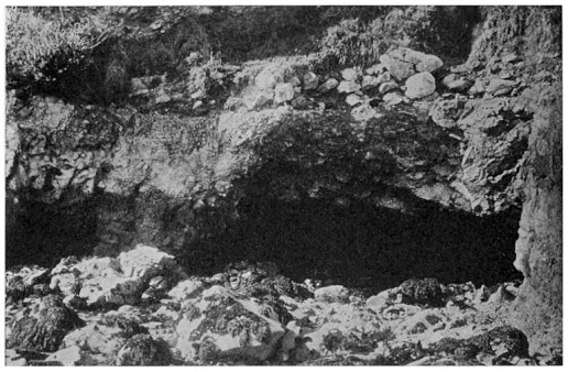
FIG. 34.—OCEAN CAVE AT LOW TIDE
Pebbles of a former beach are seen above
Upon the seaward face of San Pedro Hill, in southern California, there are eleven terraces, rising to a height of twelve hundred feet. What an interesting record this shows! Long ago the land stood twelve hundred feet lower than at present, and the waves beat about San Pedro Hill, nearly submerging it. Then the land began to rise, but stopped after a time, and the waves cut a terrace. The upward movement was continued, with repeated intervals of rest, until the land stood higher than it does now.
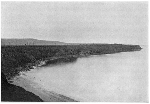
FIG. 35.—WAVE-CUT TERRACES
Point San Pedro, California
North of San Francisco there stands a terrace fourteen hundred feet above the ocean. Numerous terraces appear along the Oregon coast, but those in Washington are not as high as those in California. It is probable that the land in this region was not so deeply submerged.
The ancient shore lines of British Columbia and Alaska are now deeply buried beneath the ocean, as those of California once were. The fiords, so common in these countries, are old river valleys which have been drowned by the sinking of the land. The islands were once portions of the coast mountains, but have been cut off by the same process.
Let us picture in our minds the changes in the geography of the Pacific coast of the United States which must have been made by a sinking of the land to a depth of only six hundred feet. We will begin upon the north, at the Strait of Fuca.
Puget Sound once opened to the south as well as to the north, so that the Olympic Mountains formed an island. The broad and fertile Willamette Valley was but an arm of the sea, somewhat like Puget Sound to-day. The body of water which once filled this valley has been called Willamette Sound. The ocean overspread the low Oregon coast, and reached far up the valleys of the Umpqua and Rogue rivers. But the boundaries of the Klamath Mountains were not greatly changed, for in many places they rise quite abruptly from the present shore line.
All the large valleys of California were flooded, including the San Joaquin-Sacramento valley, which was then a great sound, open to the ocean in the region of the present Strait of Carquinez. The Coast range was broken up into islands and peninsulas. The islands off the coast of southern California are high and therefore were not entirely submerged. The Gulf of California spread over the Colorado Desert, while from the west the water penetrated inland over the plain of Los Angeles to a point beyond San Bernardino, so that at the San Gorgonio pass only a narrow neck of land connected the San Jacinto Mountains and the Peninsula Range with the mainland.
If California had been inhabited at this time, the state would not have been noted for orchards and grain-fields, but rather for its mineral wealth. There would have been comparatively little low land fit for cultivation, but the mountains, where almost all the precious metals are found, would have appeared nearly as they do to-day.
The surface of the earth may be divided into the ocean basins and the continental masses which rise above them, but we must not make the mistake of thinking that the shore line always corresponds with the border of the continental masses. We have learned that the land is almost always moving slowly up or down, so that the shore is continually changing back and forth. At one time the shore line may be far within the borders of the continent, as we have seen was once the case upon our Pacific coast; at another time, if the land should rise, the shore line might coincide with the real border of the continent. By the real border of the continent we mean the line along which the earth slopes down steeply to the abysmal depths of the ocean.
It is an interesting fact that outside the present shore line of California there is a submerged strip of the continent varying from ten to one hundred and fifty miles in width. This strip of land is like a bench upon the side of the continent, and is known as the continental plateau. The water over the plateau is comparatively shallow. Upon one side the land rises, while upon the other there is a rapid descent into the deep Pacific. The surface of the plateau is in general fairly smooth, but in places mountains lift their summits above the water and form islands.
There was a time, thousands of years earlier than the period when California was so nearly covered by the waters of the Pacific, when this land stood far higher than it does now. The coast line was then much farther west, near the border of the submarine plateau. The Santa Barbara Islands at that time formed a mountain range upon the edge of the continental land. This fact was established by the discovery upon one of the islands of a large number of bones of an extinct American elephant. These animals could have reached the submerged mountains only at a time when there was dry land between them and the present shore line. We should like to know how it came about that these bones were left where they are. Perhaps the land sank so suddenly that the water cut the elephants off from the mainland and compelled them to spend the remainder of their lives upon these islands.
While the land stood so high, some of the larger streams wore deep channels across what is now the submarine plateau. These channels have been discovered by soundings made from the ships of the United States Coast Survey. The largest of the submerged valleys extends through the Bay of Monterey, and runs so close to the shore that it has offered a favorable location for a wharf.
Before the buried valleys upon the northern coast of California were all known, the presence of one of them led to the wreck of a ship. The shore was obscured by fog, but the soundings made by the sailors showed deep water and led them to believe they were a long distance from land, when suddenly the ship drifted in upon the rocks.
The last significant movement of the land of the Pacific border was a downward one. It flooded the mouths of the streams and formed all the large harbors which are of so great commercial importance.
San Francisco Bay occupies a great stretch of lowland at the meeting of several valleys of the Coast Ranges and forms the outlet for the most important drainage system of California. If this region had been settled before the subsidence of the land which let in the ocean through the Golden Gate, how the farmers would have lamented the flooding of their fertile lands! But we can understand how small the loss would have been, compared with the advantages to be gained from the magnificent harbor which now exists here. If the land had not sunk the history of the Pacific coast would have been far different.
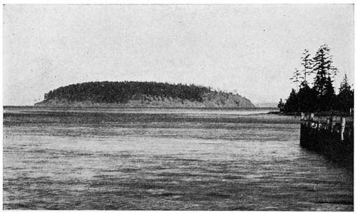
FIG. 36.—ISLAND ROUNDED BY A GLACIER
Near Anacortes, Puget Sound
Puget Sound, another very important arm of the ocean, is also a submerged valley, but it has had an entirely different history from that of San Francisco Bay. The valley was at one time occupied by a great glacier which came down from the Cascade Range and moved northwest through the sound and into the Strait of Juan de Fuca, scouring and polishing the rocks over which it passed. A little island near Anacortes (Fig. 36) has been rounded by the action of the ice into a form like a whale's back.
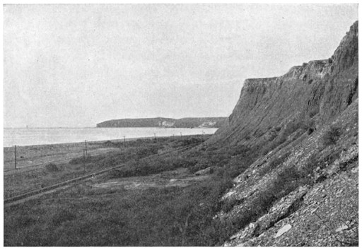
FIG. 37.—AN ABANDONED OCEAN CLIFF
Southern California
The sinking of the land flooded the lower Columbia River and the mouth of the Willamette, so that ocean ships may now go up as far as Portland. The currents and waves soon threw up bars across the mouths of the smaller streams, and formed lagoons behind them. Ships frequently have difficulty in entering many of the harbors because of the sand bars which have been built up part way to the surface of the water.
It is thought that along some portions of the coast there has recently been a slight upward movement of the land. Figure 37 shows a bit of California coast, near San Juan, where the Santa Fé railroad has laid its tracks for several miles along a strip of abandoned beach, at the base of a cliff against which the waves once beat.
FIG. 38.—LIMESTONE CLIFF, QUATSINO SOUND, VANCOUVER ISLAND
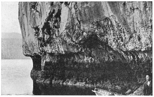
At the northern end of Vancouver island there is a deep arm of the ocean called Quatsino Sound. A limestone cliff upon the shore of this sound (Fig. 38) has been undermined by the dissolving of the limestone, but now the water lacks three feet of rising to the notch which it recently formed.