THE DISCOVERY OF THE COLUMBIA RIVER
Reading edition
The influence exerted by the various features of the land and water upon the settlement of a new region are not always fully appreciated. If the entrance to San Francisco Bay had been broader and more easily discerned by the early navigators who sailed past it, and if the mouth of the Columbia River had not been obscured by lowlands and a line of breakers upon the bar, the history of western America would probably have been very different.
In the seventeenth century the prospect seemed to be that Spain would control the Pacific Ocean. She claimed, by right of discovery, all the lands bordering upon this ocean and the exclusive right to navigate its waters. Every vessel found there without license from the court of Spain was, by royal decree, to be confiscated.
It is interesting, after all these years and with our present knowledge, to look back and see how unreasonable were the claims of Spain. In the fifteenth century the extent of the Pacific ocean was not known. In fact, men's ideas as to the distribution of land and water over the earth were so indefinite that it was at first supposed that the islands which Columbus discovered belonged to the East Indies.
The claims of Spain to the Pacific Ocean were based upon its discovery by Balboa, but she never made any serious efforts to enforce them, for the attempt would have involved her in war with all the maritime nations of Europe. Spain lacked the ability to take advantage of the great discoveries which her navigators and explorers had made, and for that reason she merely looked on, though with jealous eyes, when in the eighteenth century the ships of England, France, Holland, and Russia entered the Pacific Ocean with a view to exploration and conquest.
Determined at last to support their claim to the Pacific coast of North America, the Spaniards began to realize the necessity of exploring it more fully and of founding settlements. It was their plan to take possession of the whole region between Mexico upon the south and the Russian trading posts along the shores of Alaska. As exploration by land was impossible because of mountain ranges and deserts, the Spanish adventurers were forced to rely upon the ocean, with all its uncertainties of storm and contrary winds.
Between 1774 and 1779 voyages were made as far north as Queen Charlotte's Island, in latitude 54°. A station was established and held for many years at Nootka Sound, upon the west coast of Vancouver Island. The first expedition passed the Strait of Juan de Fuca apparently without seeing it, although there was a rumor to the effect that a broad opening into the land had been discovered by a certain Juan de Fuca in 1592, while he was exploring in the employ of Spain. The latitude of this opening, as he gave it, nearly corresponds to that of the strait which now bears his name.
For many years the attempt to discover a passage around the northern part of America engaged the early navigators upon both the Atlantic and Pacific oceans. Their desire to find an easy route to India spurred them to constant effort. For a time it was believed that such an opening actually existed, and mariners went so far as to give it a name, calling it the Straits of Anian. The reputed discoveries of Juan de Fuca materially strengthened the general belief in a passage to the northward of America.
Vizcaino, in his voyage of 1603, reached latitude 43° north and thought that he had discovered a great river flowing into the Pacific Ocean. This opening, although south of the point supposed to have been reached by Juan de Fuca, was believed for a time to be the entrance to the long-sought Straits of Anian. During the latter part of the seventeenth century California was represented upon the Spanish maps as an island having Cape Blanco, which Vizcaino discovered and named, as its northern point, and separated from the mainland by an extension of the Gulf of California northward.
To return now to the Spanish explorations, in the latter part of the seventeenth century we find that Heceta, following the first expedition, succeeded in getting as far as Vancouver Island, where, having been parted from an accompanying ship by a storm, he turned southward, passing the Strait of Juan de Fuca and keeping close by the shore. In latitude 46° 17' he found an opening in the coast from which a strong current issued. He felt sure that he had discovered the mouth of some large river. Upon the later Spanish maps this was called Heceta's Inlet, or River of San Roque. A glance at the map will show how closely the latitude given corresponds to the mouth of the river which was discovered later by Captain Gray and named, after his ship, the Columbia.
A short time before Heceta's discovery, Captain Jonathan Carver of Connecticut set out on an exploring tour, partly for the purpose of determining the width of the continent and the nature of the Indian inhabitants. He mentions four great rivers rising within a few leagues of one another, "The river Bourbon (Red River of the North) which empties itself into Hudson's Bay, the waters of the St. Lawrence, the Mississippi, and the river Oregon, or River of the West, that falls into the Pacific Ocean at the Straits of Anian." Carver's descriptions are fanciful, and it is not likely that he ever saw the river which is now known as the Columbia, although there is a possibility that he heard stories from the Indians of a great river upon the western slope of the Rocky Mountains, and invented for it the name Oregon.
In 1787 Meares, an English trader, visited the coast, and sailing southward from the Strait of Juan de Fuca, attempted to find the river San Roque as it was laid down upon the Spanish charts. Reaching the proper latitude, Meares rounded a promontory and found behind it a bay which he was unable to enter because of a continuous line of breakers extending across it. He became satisfied that there was no such river as the San Roque, and named the promontory Cape Disappointment and the bay Deception Bay. If Meares had entered the bay through the breakers, the English would undoubtedly have made good their claim to the discovery of the Columbia River.
After the Revolution, American trading ships began to extend their operations into the North Pacific. In 1787 two such vessels left Boston, one of them under command of a Captain Gray. After reaching the Pacific, the ships were parted during a storm, and Captain Gray finally touched the American coast near the forty-sixth degree of north latitude. For nine days he tried to enter an opening which was in all probability the one attempted by Meares. After nearly losing his ship and suffering an Indian attack, he sailed north to Nootka Sound.
Captain Gray returned to Boston, but in 1790 started upon another trading expedition in command of the ship Columbia. Arriving safely in the North Pacific, he spent the winter of 1791-1792 upon Vancouver Island.
Vancouver, whose name has been given to the largest island upon the western coast of North America, and who did so much to make known the intricate coast line of the Puget Sound region, arrived upon the scene in 1792. He was authorized to carry on explorations, and to treat with Spain concerning the abandonment of the Spanish claim to Nootka Sound.
Vancouver sailed up the coast, keeping a close lookout for the river San Roque. No opening in the land appeared, although at one spot he sailed through a muddy-colored sea which he judged was affected by the water of some river. Upon reaching the Strait of Fuca, Vancouver expressed the opinion that there was no river between the fortieth and forty-eighth degrees of north latitude, "only brooks insufficient for our vessels to navigate."
Shortly after this time, Vancouver met Captain Gray with his ship Columbia. The disheartened explorer placed no confidence in Captain Gray's report that, upon his former voyage, he had discovered a large river to the south. Vancouver in his narrative says, "I was thoroughly convinced that we could not possibly have passed any safe navigable opening, harbor, or place of security for shipping on this coast from Cape Mendocino to the promontory of Closset" (Cape Flattery).
Captain Gray, however, determined to make further investigations. He sailed southward and entered a port now known as Gray's Harbor, where he spent several days trading with the Indians. From this harbor he ran on south for a few miles past Cape Disappointment, and then sailed through an opening in the breakers into a bay which he supposed formed the mouth of the river of which he was in search. He finally anchored, as he says, "in a large river of fresh water."
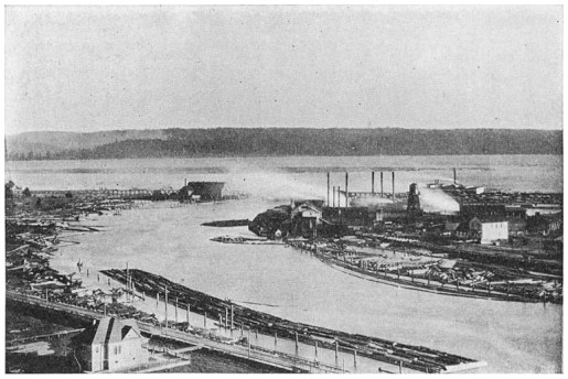
FIG. 39.—A SCENE ON GRAY'S HARBOR, WASHINGTON
Showing sawmills and log booms
Later Captain Gray took the vessel twelve or fifteen miles up the river, and would have gone farther if he had not wandered into the wrong channel. When he left the river he named it the Columbia in honor of his vessel. Thus by the right of actual discovery the United States was at last able to make good its claim to the river.
The English claimed that Gray did not enter the river itself, as the tide sets up many miles farther than the point which his ship reached. They insisted that what he saw was simply a bay. But the truth is that Gray was actually in the mouth of the river. The mere fact that the tide enters the lower portion of the river makes no difference. The actual mouth of the Columbia is marked by the north and south coast line. The entrance of the tide water, and the backing of the current for many miles up stream, is the result of a recent sinking of the land. The same features are presented by the Hudson River.
If the English had discovered and entered the river first it is probable that this stream would have become the boundary line between the United States and British Columbia, in which case the whole northern portion of the Oregon territory would have been lost to us. As it was, the English laid insistent claim to the northern bank of the river and established trading posts at various points. The lowest of these posts stood upon the site of Fort Vancouver, a little above the mouth of the Willamette River.
The famous exploring expedition under Captains Lewis and Clark wintered at the mouth of the Columbia in 1804-1805, in a group of rude log cabins known as Fort Clatsop. The first settlement in the vicinity was made in 1811, when a fur company organized by John Jacob Astor attempted to establish a trading post upon the Columbia. Two parties were sent out from New York. One travelled by water around Cape Horn, while the other, with great difficulty, crossed the continent by the way of the Missouri, Snake, and Columbia rivers. The undertaking proved unsuccessful, for after the War of 1812 began supplies could no longer be sent safely to the post.
The Astor company finally surrendered its establishment to an English company, and in this way the control of the river was transferred to England. With the return of peace the post was restored to the United States, and its location is marked now by the city of Astoria.
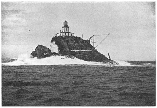
FIG. 40.—TILLAMOOK ROCK
Near the mouth of the Columbia River
What small things sometimes determine the trend of great events! A little more care and energy on the part of Vancouver or Meares would have placed the Columbia River in the hands of the English. The existence of an open river mouth without any breaking bar would have brought about the same result.
The Spaniards came first to the Pacific slope, claiming the whole coast as far north as the Russian possessions. Later the United States, by treaty with Spain and Russia, acquired a right to all that portion of the Pacific coast of North America which lies between California and the Russian possessions. But because of the greater energy of the English, and the failure upon the part of the United States to realize the value of this vast region, a considerable section was again lost by the terms of the treaty which made the forty-ninth parallel the boundary line. The intelligence and energy of Captain Gray alone preserved to us the rich lands of Washington.
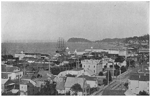
FIG. 41.—ASTORIA, OREGON
At the mouth of the Columbia River