FRÉMONT'S ADVENTURES IN THE GREAT BASIN
Reading edition
Frémont, "the Pathfinder," did greater service than any other man in making known the geographic features of the Cordilleran region. In the fifth decade of the last century, while California still belonged to Mexico and the pioneers were turning their attention to the Oregon country, Frémont organized and conducted three exploring expeditions under the direction of the government. When in California upon the third expedition he took part in the skirmishes which resulted in the transference of this section to the United States.
A fourth expedition, undertaken by Frémont on his own account, resulted disastrously. The explorers foolishly tried to cross the Rocky Mountains in the middle of winter, but had to give up the attempt after many of the party had died from cold and starvation.
It is hard for us to realize, now, that only sixty years ago the territory lying between the Rocky Mountains and the Pacific coast was practically unknown. Try to imagine the feelings of emigrants, bound for the gold-fields of California, who have pushed into the Great Basin without knowing where to look for grass or water. They are camped by a spring of alkaline water scarcely fit to drink; their weary animals nibble at the scanty grass about the spring; far ahead stretches the pathless desert which they must cross; upon their choice of a route their very lives will depend.
Now it is all changed. The whole region is crossed and recrossed by wagon roads and railways. Many mining towns are scattered through the mountains which dot the seemingly boundless expanse of desert, while in every place where water can be found there are gardens, green fields of alfalfa, and herds of cattle.
Before the year 1840 some knowledge had been acquired of the borders of the Great Basin. Trappers and explorers had crossed the Rocky Mountains and had gone down the Columbia River. There were Spanish settlements in New Mexico, Arizona, and along the coast of California.
Frémont's first expedition had taken him to the summit of the Rocky Mountains in northwestern Wyoming. In 1843 he started upon the second expedition. He was at that time commissioned to cross the Rockies, descend the Columbia to Fort Vancouver, and return by a route farther to the south, across the unknown region between the Columbia and the Colorado rivers.
Let us follow the little band of explorers led by Captain Frémont as day after day they made their way across what was then a trackless waste, and see what troubles they encountered because of the inaccuracy of the maps of that period.
Leaving Fort Vancouver, upon the lower Columbia, for the return trip, the party ascended the river to The Dalles and then turned southward along the eastern side of the Cascade Range. They soon entered upon a region never before traversed by white men. At the time when autumn was giving place to winter, without reliable guides or maps, they were to cross the deserts lying between them and the Rocky Mountains.
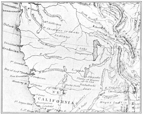
FIG. 47.—MAP OF A PORTION OF WESTERN NORTH AMERICA, MADE IN 1826
Showing the Buenaventura River
They met with no great difficulties until they had gone as far south as Klamath Lake. "From this point," Frémont says, "our course was intended to be about southeast to a reported lake called Mary's, at some days' journey in the Great Basin, and thence, still on southeast to the reputed Buenaventura (good chance) River, which has had a place on so many maps, and countenanced the belief in the existence of a great river flowing from the Rocky Mountains to the Bay of San Francisco."
Figure 47 shows one of the maps to which Frémont refers. How interesting it is! Compare it with a good map in your geography and you will readily see that it is very misleading. The Sierra Nevada, one of the greatest mountain ranges in the United States, hardly appears, while traced directly across the map is the great Buenaventura River which Frémont expected to find and follow eastward toward its source near the Rocky Mountains.
If this river had really been where it was mapped, it is likely that Frémont would have had no trouble, for if hard pressed he could have followed the stream down to the ocean. But a wall of snow-covered mountains lying in the way made matters very different.
Winter was coming on when the party entered what is now northwestern Nevada, looking for the Buenaventura River. For several weeks they toiled on, often through the snow. Concerning this part of the journey Frémont says: "We had reached and run over the position where, according to the best maps in my possession, we should have found Mary's lake or river. We were evidently on the verge of the desert, and the country was so forbidding that we were afraid to enter it."
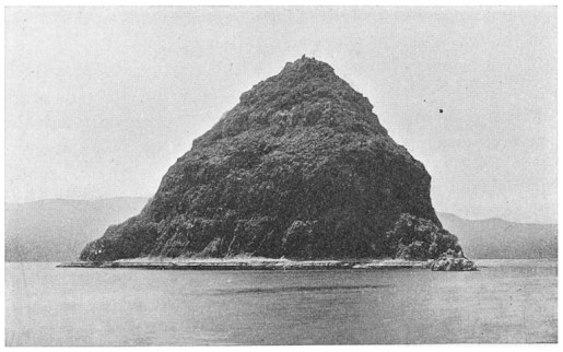
The party then turned south, still hoping that the river might be discovered. After a time they came upon a large lake and travelled for many miles along its eastern shore. One camp was made opposite a tall, pyramid-shaped island, the white surface of which made it conspicuous for a long distance. Frémont was much impressed by the resemblance of the island to the pyramids of Egypt and so named the body of water Pyramid Lake. At the southern end of the lake the travellers found a large stream flowing into it (now known as the Truckee River), and followed along its banks for some distance; but as the river turned toward the west, they left it and struck out across the country.
Frémont says again, "With every stream I now expected to see the great Buenaventura, and Carson (Kit Carson, the famous scout) hurried eagerly to search on every one we reached for beaver cuttings, which he always maintained we should find only on waters which ran to the Pacific."
FIG. 48.—PYRAMID ISLAND, PYRAMID LAKE, NEVADA
But all the streams flowed in the wrong direction, until at last the explorers grew weary of hunting for the river which had no existence. Although it was the middle of the winter, Frémont determined to cross the lofty Sierras which rose like a white wall to the west. Once over the mountains, he hoped to gain the American settlements in the Sacramento Valley, where already Sutter's Fort had been established.
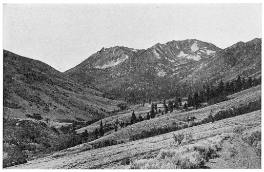
The party ascended Walker River, dragging, with great difficulty, a howitzer which they had brought with them. The snows grew deeper as storm succeeded storm. Feeling that they were really lost, the disheartened men at length abandoned the gun, at a spot which has since been named Lost Cañon.
FIG. 49.—LOST CAÑON, EASTERN SLOPE OF THE SIERRA NEVADA MOUNTAINS
When their own provisions were nearly gone, the party obtained some pine nuts and also several rabbits from the Indians. A dog which had been brought along made one good meal for the wayfarers. An Indian who had been persuaded to act as guide pointed out the spot where two white men, one of whom was Walker, a noted frontiersman, had once crossed the mountains; but the guide made them understand that it was impossible to cross at that time of the year, saying, in his own language, "Rock upon rock, snow upon snow."
although they could advance only by breaking paths through the snow, and were reduced to eating mule and horse flesh, yet the Frémont party pushed on. Finally they reached the summit of the mountains and turned down by the head of a stream flowing westward, which proved to be the American River. After three weeks more of terrible suffering they came out of the mountains at Sutter's Fort, where they obtained supplies and had an opportunity to rest and recruit.
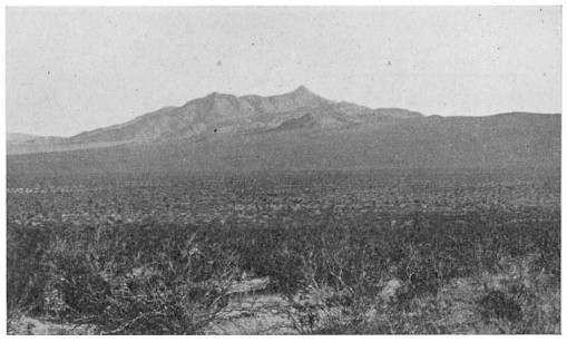
FIG. 50.—FRÉMONT PEAK, MOHAVE DESERT
Frémont now recognized the incorrectness of the maps which had so nearly caused the destruction of the party. As he says in his notes: "No river from the interior does, or can, cross the Sierra Nevada, itself more lofty than the Rocky Mountains... There is no opening from the Bay of San Francisco into the interior of the continent."
When the return journey was begun the party did not recross the high Sierras, but turned southward through the San Joaquin Valley and gained the Mohave Desert by the way of Tehachapai pass. The route now led eastward across the deserts and low mountain ranges of California and southern Nevada, until at last Great Salt Lake was reached.
FIG. 51.—SAGE-BRUSH IN THE GREAT BASIN
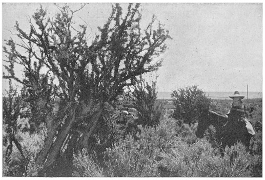
Among the many geographical discoveries of the expedition was the demonstration of the existence of the Great Basin. In his report, Frémont, while speaking of its vast sterile valleys and of the Indians which inhabit them, says: "That it is peopled we know, but miserably and sparsely ... dispersed in single families ... eating seeds and insects, digging roots (hence their name) [Digger Indians], such is the condition of the greater part. Others are a degree higher and live in communities upon some lake or river from which they repulse the miserable Diggers.
"The rabbit is the largest animal known in this desert, its flesh affords a little meat.... The wild sage is their only wood, and here it is of extraordinary size—sometimes a foot in diameter and six or eight feet high. It serves for fuel, for building material, for shelter for the rabbits, and for some sort of covering for the feet and legs in cold weather. But I flatter myself that what is discovered, though not enough to satisfy curiosity, is sufficient to excite it, and that subsequent explorations will complete what has been commenced."