HOW THE COLUMBIA PLATEAU WAS MADE
Reading edition
Years ago people disputed as to the way in which the earth was made. Those who lived where all the rocks had, like lava, the appearance of having once been melted, believed that fire had done all the work. Those who lived where the rocks appeared to be formed of hardened mud, sand, and lime, substances such as we find accumulating under water, said that water alone had been the means. But in later years the earth's surface has been more widely explored, and now it is known that both opinions were partly right. Water and fire have both been concerned in the making of the earth.
In the great valleys fire-formed rocks are rare, but they are more or less abundant in all mountainous regions, for where mountains are, there the crust of the earth is weakest. There are many reasons for believing that the interior of the earth is very hot. We know that the surface is settling in some places and rising in others, and that where the strain of the upheaval is too great the rocks are broken. These convulsions sometimes cause earthquakes and sometimes volcanic eruptions, when enormous quantities of molten rock are poured out over the surface. In all the long history of our earth probably no greater flood of lava than that which made the Columbia plateau was ever spread over the surface of any region. Travel where you will over the plains of southern Idaho, central Washington, or Oregon, and examine the rocks which here and there rise above the soil or are exposed in the cañons, and you will find that they all appear to have been formed by fire.
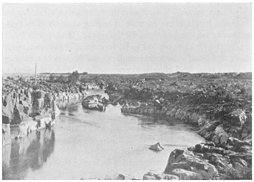
FIG. 7.—SNAKE RIVER AT IDAHO FALLS
Just beginning to cut a cañon in the volcanic plateau
These rocks are dark in color and very hard. They are not arranged in regular layers like sandstone and shale; many of them show numerous little cavities which once contained steam. These cavities give to the rock a slag-like appearance. In this kind of rock, which we shall call lava, there are, of course, no remains of shells or bones of animals such as are often found in rocks formed from sand or clay.
Do not picture to yourself the Columbia plateau as one continuous stretch of level land, for it is broken by many mountain ranges. Some of these are old mountains which were too tall to be buried by the lava, but most of them have been formed out of the plateau itself. The eruptions which made the plateau extended through a very long time, perhaps hundreds of thousands of years, and the older lava is deeply decayed and covered with soil. Some of the later flows show extremely rough and rugged surfaces and are probably only a few hundred years old.
MAP OF THE COLUMBIA PLATEAU
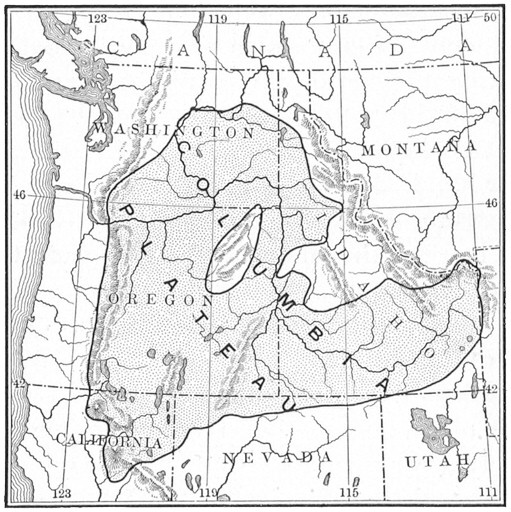
Long ago, before the eruptions began, the geography of the Northwest was very different from what it is now. Instead of a vast plateau there were mountains and valleys. Lowlands occupied most of the region where the Cascade Range now rises with its lofty volcanic peaks. Portions of the basin of the present Columbia River were occupied by lakes which extended southwest into California.
Movements of the earth began to affect the region of the present plateau, and at many points the solid rocks were fissured and broken. Then from that mysterious region far beneath the surface came steam and gases, escaping through the fissures with explosive force. In some places cinder cones were built about the openings by the fragments of lava which were hurled out. In other places, during periods of less explosive eruption, molten lava flowed out in vast quantities. The lava was very hot and almost as liquid as water, so that it spread in thin sheets over hundreds of square miles of lowland.
One important series of fissures through which eruptions took place marked the line where the Cascade Range was to be built. Other volcanoes appeared over the surface of southern Idaho, central Washington, Oregon, and northeastern California.
The eruptions were not continuous over the whole field; now in this place, now in that, there came long periods of quiet. During such periods the earthquakes ceased, the lava became cold, and the clouds of volcanic ashes cleared from the air. Frequently the lava intercepted streams and blocked the valleys so that large lakes were formed. Whenever the periods of quiet were very long, plants spread over the surface and animals of many kinds made their homes about the lakes.
In eastern Oregon the John Day River and its branches have eroded cañons through the later lava and have exposed the sands, clays, and gravels which collected at the bottom of one of those ancient lakes. In these beds the skeletons of many strange and interesting animals have been found. Evidently they had once lived about the borders of the lake, and the streams had washed their bones into the water and mingled them with the sediment.
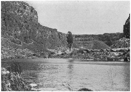
FIG. 8.—BLUE LAKES, IDAHO
Formed by springs issuing from underneath the lava of the plateau
One of these animals appears to have been an ancestor of the present horse. It was about the size of a sheep, and had three toes instead of one. Another, probably a very dangerous animal, was related to our present hog, but stood nearly seven feet high. Others resembled the rhinoceros, camel, tapir, or peccary. All but the peccary are now extinct upon this continent. Of the carnivorous animals there were wolves and cats of large size.
The eruptions continued, filling the valleys little by little, until in places the lava reached a thickness of nearly four thousand feet. The lower mountains were hidden from sight. We know of the existence of these buried mountains because the wearing away of the lava in some places has exposed their summits to view.
The lava flood reached farther and farther. In southern Idaho it formed the Snake River plains, which must have been, when first formed, hundreds of miles long, seventy-five miles wide, and almost as even as a floor. If we could have looked on while these things were taking place it would have appeared as if the whole land was about to sink under the fiery mass which flowed out of the earth. The streams and valleys were completely buried. The region of the John Day Lake, with all its animal remains, was covered. The lava, like a sea, crept up against the mountains surrounding the plateau region. Bays of lava extended into the valleys among the mountains, while mountain ridges rose like islands and capes from the surface of the flood.
We never tire of looking at the lofty snow-capped peaks of the Cascade Range. A dozen of them rise over ten thousand feet, and two, Mounts Shasta and Ranier, are more than fourteen thousand feet high. All these mountains were formed of material thrown out of the interior of the earth during the building of the Columbia plateau. The process was very similar for each. About some one exceptionally active crater immense quantities of scoriæ[1] and lapilli[2] accumulated. Then came streams of fiery lava, some of which, hardening upon the outer slopes of the crater, added still more to the growth of the mountain. The process was very slow, however. A time of eruption, marked by tremblings of the earth, explosive noises, and a sky filled with dust and clouds, might last for many years. Then came a long period of rest when the falling rains, gathering in dashing torrents, cut deep gullies down the sides of the mountain.
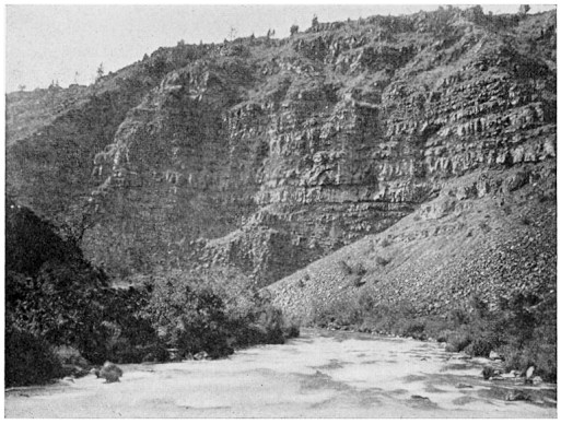
FIG. 9.—PITT RIVER CAÑON, NORTHERN CALIFORNIA
The plateau is built of layers of lava
The volcanoes at last ceased to grow any higher, for the lava, if the eruptions continued, formed new craters at their bases. It is probable that all these great peaks have been extinct for several thousand years, although some are much older and more worn away than others. One of these volcanoes has completely disappeared, and in its place lies that wonderful sheet of water known as Crater Lake. It is thought that the interior of this mountain was melted away during a period of activity, and that the outer portion fell in, leaving a crater five miles across and nearly a mile deep.
The streams of lava, as they flowed here and there building up the plateau, frequently broke up the rivers and turned them into new channels. As time went on the eruptions were less violent, and the rivers became established in the channels which they occupy to-day. The Columbia River, winding about over the plateau, sought the easiest path to the sea. It soon began to dig a channel, and now has hidden itself between dark walls of lava.
But other forces besides the streams were now at work in this volcanic region. The lava plateau began slowly to bend upward along the line of the great volcanoes, lifting them upward with it. In this manner the Cascade Range was formed. The Columbia River, instead of seeking another way to the sea, continued cutting its channel deeper and deeper into the growing mountain range, and so has given us that picturesque cañon which forms a most convenient highway from the interior of Washington and Oregon to the coast.
Take a sheet of writing paper, lay it upon an even surface, then slowly push the opposite edges toward each other. This simple experiment will aid one in understanding one of the ways in which mountain ranges are made. Besides the upward fold of the plateau which made the Cascade Range, another was formed between the Blue Mountains in eastern Oregon and a spur of the Rocky Mountains in northern Idaho. This fold lay across the path of the Snake River, but its movement was so slow that the river kept its former channel and in this rising land excavated a cañon which to-day is more than a mile deep. The upper twenty-five hundred feet of the cañon are cut into the lava of the plateau, and the lower three thousand into the underlying granite. The cañon is not so picturesque as the Colorado, for it has no rocks with variegated coloring or castellated walls. Its sides are, however, exceedingly precipitous and it is difficult to enter.
FIG. 10.—SHOSHONE FALLS, SNAKE RIVER, IDAHO
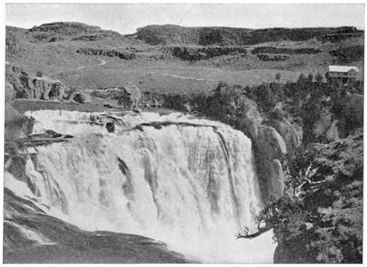
Along portions of the lower Columbia and Snake rivers, navigation is obstructed by rapids and waterfalls. The presence of these falls teaches us that these streams are still at work cutting their channels deeper. The Snake River in its upper course has as yet cut only a very shallow channel in the hard lava, and the beautiful Shoshone Falls marks a point where its work is slow. These falls, which are the finest in the northwest, owe their existence to the fact that at this particular spot layers of strong resistant lava cover the softer rocks.
There are other cañons in the plateau region which are fully as remarkable as those which have been mentioned. That of the Des Chutes River in central Oregon is in places a thousand feet deep, with almost vertical walls of lava.
We have already seen how mountains have been formed upon the Columbia plateau, by a bending of the earth upward. Other mountains of the plateau are due to fractures in the solid rocks, often many miles long. Upon one side of these fractures the surface has been depressed, while upon the other it has been raised. The amount of the uplift varies from a few hundred to thousands of feet. The mountains thus formed have a long, gentle slope upon one side and a very steep incline upon the other. They are known as "block mountains," and those upon the Columbia plateau are the most interesting of their kind in the world.
With the exception of a few large rivers, the greater portion of the Columbia plateau is remarkable for its lack of surface streams. The water which reaches the borders of the plateau from the surrounding mountains often sinks into the gravel between the layers of lava and forms underground rivers. The deep cañons which have been mentioned intercept some of these underground rivers, so that their waters pour out and down over the sides of the cañons in foaming cascades. The greatest of these cascades is that known as the Thousand Springs in the Snake River cañon. The waters of the Blue Lakes in the cañon of the same river below Shoshone Falls also come from underneath the lava. They are utilized in irrigating the most picturesque fruit ranch in southern Idaho.
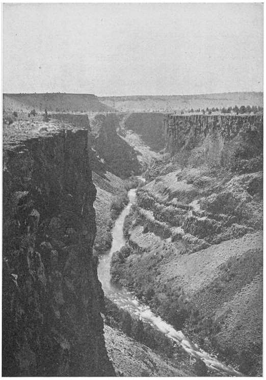
FIG. 11.—CAÑON OF CROOKED RIVER NEAR THE DES CHUTES RIVER
Eroded in the Columbia plateau
The climate of the plateau is dry, and its eastern portion is practically a desert. Toward the west, however, the rainfall is greater, and in central Washington and northern Oregon the plateau becomes one vast grain-field. It is difficult to irrigate the plateau because the streams flow in such deep cañons, but above the point where the cañon of the Snake River begins there is an extensive system of canals and cultivated fields. With a sufficient water supply, the lava makes one of the richest and most productive of soils. Along the Snake and Columbia rivers, wherever there is a bit of bottom land, orchards have been planted. Little steamers ply along these rivers between the rapids, gathering the fruit and delivering it at the nearest railroad point.
Mining is carried on only in the mountains which rise above the lava flood, for the mineral veins are for the most part older than the lava of the plateau. We are certain that many very valuable deposits of the precious metals lie buried beneath the lava fields.
It is thought that the volcanic history of the Columbia plateau has been completed. Now the streams are at work carrying away the materials of which it is composed and may in time uncover the old buried land surface.