THE STORY OF GREAT SALT LAKE
Reading edition
The most interesting geographical feature of Utah is the Great Salt Lake. Few tourists now cross the continent without visiting the lake and taking a bath in its briny waters. This strange body of water has, however, been slowly growing smaller for some years, and probably will in time disappear. A study of the history of the lake may throw some light upon the important question of its possible disappearance, and it will certainly bring out many interesting facts.
We do not know with certainty who was the first white man to look upon this inland sea, although it is supposed to have been James Bridger, a noted trapper, who in 1825 followed Bear River down to its mouth. He tasted the water and found it salt, a fact which encouraged him in the belief that he had found an arm of the Pacific Ocean.
More than two hundred years ago there were vague ideas about a salt lake situated somewhere beyond the Rocky Mountains. In 1689 Baron Lahontan published an account of his travels from Mackinac to the Mississippi River and the region beyond. He states that he ascended a westerly branch of the river for six weeks, until the season became too late for farther progress. He reports meeting savages who said that one hundred and fifty leagues beyond there was a salt lake, "three hundred leagues in circumference—its mouth stretching a great way to the southward."
This imaginative story aroused interest in the West. In a book published in 1772, devoted to a description of the province La Louisiane, the possibility of water communication with the South Sea is discussed as follows: "It will be of great convenience to this country, if ever it becomes settled, that there is an easy communication therewith, and the South Sea, which lies between America and China, and that two ways: by the north branch of the great Yellow River, by the natives called the river of the 'Massorites' (Missouri), which hath a course of five hundred miles, navigable to its head, or springs, and which proceeds from a ridge of hills somewhat north of New Mexico, passable by horse, foot, or wagon, in less than half a day. On the other side are rivers which run into a great lake that empties itself by another navigable river into the South Sea. The same may be said of the Meschaouay, up which our people have been, but not so far as the Baron Lahontan, who passed on it above three hundred miles almost due west, and declares it comes from the same ridge of hills above mentioned, and that divers rivers from the other side soon make a large river, which enters into a vast lake, on which inhabit two or three great nations, much more populous and civilized than other Indians; and out of that lake a great river disembogues into the South Sea."
In 1776 Father Escalante travelled from Santa Fé far to the north and west. He met Indians who told him of a lake the waters of which produced a burning sensation when placed upon the skin. This was probably Great Salt Lake, but it is not thought that he himself ever saw it. The Escalante Desert, in southern Utah, once covered by the waters of the lake, is named after this explorer.
Nothing more seems to have been learned of the lake after its discovery by Bridger until in 1833 Bonneville, a daring leader among the trappers, organized a party for its exploration. Washington Irving, in his history of Captain Bonneville, says of the party, "A desert surrounded them and stretched to the southwest as far as the eye could reach, rivalling the deserts of Asia and Africa in sterility. There was neither tree, nor herbage, nor spring, nor pool, nor running stream, nothing but parched wastes of sand, where horse and rider were in danger of perishing."
FIG. 52.—SCENE ON GREAT SALT LAKE
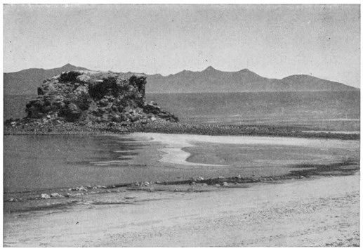
although decreasing in area so rapidly, Great Salt Lake is still the largest body of water in the western part of the United States, and the largest salt lake within its boundaries. It has a length of seventy miles and a maximum width of nearly fifty miles.
Desolate, indeed, must have appeared the surroundings of the lake, with its salt-incrusted borders, as the Mormon emigrants gained the summit of the Wasatch Range and looked out over the vast expanse to the west. But as the slopes at the foot of the mountains seemed capable of producing food for their support, they stopped and made their homes there. Now in this same region, after half a century, one can ride for many miles through as beautiful and highly cultivated a country as the sun ever looked down upon. In the early days the barren plains were broken only by mountains almost as barren, which rose from them like the islands from the surface of the Great Salt Lake. The only pleasing prospect was toward the east, where stood the steep and rugged Wasatch Range, with its snow-capped peaks. From its deep cañons issued large streams of pure, cold water, which flowed undisturbed across the brush-covered slopes, then unbroken by irrigating ditches, and at last were lost in the salt lake.
One might think that streams of water apparently so pure would at last freshen the lake, but in reality they are carrying along invisible particles of mineral matter which add to its saltness day by day. The dry air steals away the water from the lake as fast as it runs in, but cannot take the minerals which it holds in solution.
Great Salt Lake is still considered very large, but at one time it was ten times its present size, while still longer ago there was no lake at all. Without a basin there can be no lake, and at that far-away time, as we have already learned, the Great Basin did not exist, and the streams, if there were any, ran away to the ocean without hindrance.
When the Great Basin was formed by a breaking and bending of the crust of the earth, many a stream lost its connection with the ocean and went to work filling up the smaller basins, thus giving rise to the lakes which have already been described. The largest of these bodies of water, and in some respects the most interesting, is Great Salt Lake.
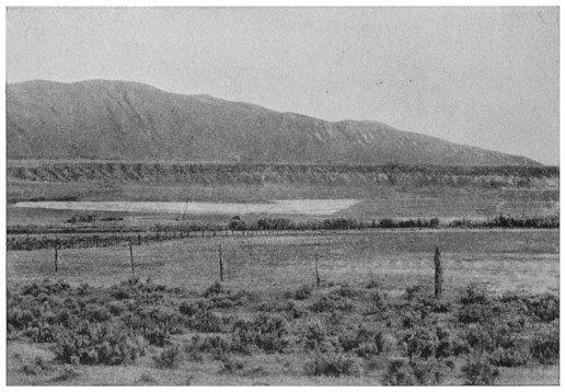
FIG. 53.—OLD SHORE LINE OF LAKE BONNEVILLE
Foot of the Wasatch Range
This lake, lying close to the lofty Wasatch Range, received so much water from numerous streams during the Glacial period that it slowly spread over thousands of square miles, overrunning the desert valleys and making islands of the scattered mountain ranges. It extended from north to south across Utah, into southern Idaho and almost to the Arizona line, until this body of water, which arose from so small beginnings, had become a veritable inland sea, three hundred miles long, one hundred miles wide, and one thousand feet deep.
By the time the lake had covered an area of twenty thousand square miles the lowest point in the rim of the basin was reached and the overflow began. No map will tell you where the outlet was, for no river exists there now. If you could explore the shore lines of this ancient lake, which has been called Bonneville after the noted trapper, you would find two low spots in the mountains which hem the waters in, one upon the south, facing the Colorado River, the other on the north toward the Snake River. The one on the north happened to be a little lower, so that the break occurred there. First as a little, trickling stream, then as a mighty, surging river, the water poured northward down the valley of a small stream, widening and deepening it until, passing the spot where now the town of Pocatello stands, it joined the Snake River.
This old outlet is now known as Red Rock Pass, and it forms an easy route for the Oregon Short Line from Salt Lake City to the plains of southern Idaho. The old river-bed is marked by marshes and fertile farms.
With an outlet established, Lake Bonneville could rise no higher, and its waves began the formation of a well-defined terrace or beach, just as waves are sure to do along every shore. The level of the water could not remain permanently at the same height, for the rocks at the outlet were being worn away by the large volume of water which flowed over them. In the course of years the level of the lake was lowered four hundred feet. The sinking was not uniform, but took place by stages, while at each period of rest the waves made a new beach line. The lake during all this time must have been a beautiful sheet of fresh water filled with fish. Its shores, also, must have been much richer in vegetation than they are now.
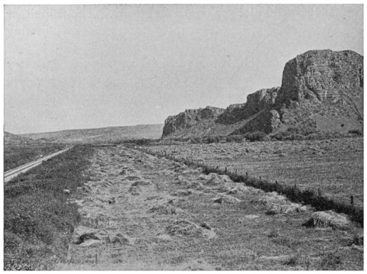
FIG. 54.—RED ROCK PASS, SOUTHERN IDAHO
Outlet of Lake Bonneville
The water remained for a long time at the level of four hundred feet below its highest stage. This fact is evident from the width of the wave-cut terrace, which is the most prominent of all those that mark the old levels along the sides of the mountains. Finally, for some reason the climate began to change, the streams supplied less water to the lake, and the evaporation from its surface became greater because the air was drier. As a result the lake was lowered to such an extent that it lost its outlet. The mighty river flowing down through Red Rock Cañon grew smaller and at last dried up altogether.
In this manner the lake was again cut off from the ocean, as it had been during its earlier history. The waters still continued to recede, but not at a uniform rate. During periods of greater rain its level remained stationary, so that the waves added new terraces to those already formed.
As the lake had no outlet and was decreasing in volume, the water became salty, for the minerals brought by the streams could no longer be carried away. The fish either died or passed up into the purer waters of the inflowing streams.
The water of the present lake is so salt that in every four quarts there is one quart of salt, and the preparation of this commodity by a process of evaporating the water in ponds has become an important industry. The water is the strongest kind of brine and it is impossible for a bather to sink in it. One floats about upon it almost as lightly as wood does upon ordinary water. After bathing it is necessary to wash in fresh water to remove the salt from the body.
The dry bed of the former Lake Bonneville stretches far to the south and west of the present lake, and forms one of the most barren and arid regions in the United States. It is sometimes called the Great American Desert.
Why is the lake receding now? Some people think that the climate is growing still more arid, and that the lake will eventually disappear. Others think that its shrinkage is the result of irrigation, for a large part of the water from the streams which supply it is now taken out and turned upon the land. There is still another reason which may account for the low water. The lake is known to rise and fall during a series of wet and dry years. When first mapped, in the middle of the last century, it was about as low as it is now. Then it gradually rose for a number of years and lately has again been falling.
The story of Great Salt Lake has been much more complicated than the statement given above, but this is sufficient for our purpose.
Irrigation has made a garden spot of a large part of the old bed of Lake Bonneville, but much of the beauty and attractiveness of this region would be lost if the present lake should give place to a bed of glistening salt. Let us hope that it will remain as it is.