VII. TUNISIA. (continued 3)
Reading edition
In the centre of the porch of the sanctuary is the square Bâb el-Behou (‘pavilion-gate’) with a great horseshoe archway and pinnacled summit. The drum and dome, formerly resembling the dome of the mihrâb, were rebuilt in 1828. The timber ceiling of the adjoining arcades is now partly replaced by brick-vaulting.
The *Main Door of the sanctuary, in cedar-wood, also was renewed in 1828 by wood-carvers from Sfax (p. 380). The wings are beautifully enriched with network, rosettes, and arabesques (p. 445). Over the door are a frieze with an inscription and another adorned with mashrebîyeh or lattice-work, and above these is a pediment decorated with charming scroll-work. The side-doors, also in cedar-wood, and partly modern, have a simpler geometric ornamentation, resembling that of the maksûra screen (p. 377).
The *Interior of the sanctuary, in the form of a so-called Egyptian cross (⟙), with a broad transept at the back, has a nave and sixteen aisles, with eight rows of arcades. In the axis of the Bâb el-Behou, above the intersection of the nave and transept, rises the dome of the mihrâb-chapel, in front of the mihrâb-recess. The timber ceilings of the aisles, dating from different centuries, still retain interesting traces of their old painting. The effect of the nave is marred by the new braces and the clumsy modern stucco-decoration of the upper walls. The candelabra are ancient, but of little artistic value. The old pavement has disappeared and so too have the tapestries once used for festivals. The somewhat colourless aspect of the interior is compensated by the beauty of the columns, which here, as well as in the court, merit careful study. The shafts, as at Cordova, are of surprisingly various materials: white and coloured marble, onyx, granite, porphyry, and variegated breccia. Besides the few Moorish capitals in the more modern parts of the mosque, we note Roman, early-Christian, Byzantine, and even Punic-Ionic forms. Owing to their unequal lengths some of the columns have been raised while others are partly buried in the earth.
The *Mihrâb Chapel, unfortunately thickly whitewashed, is specially noteworthy for its sumptuous decoration and the peculiar 377construction of its dome. The chief enrichment of the wall consists of *Fayence with gold lustre, the oldest mediæval relic of this art-industry, the origin of which seems to be indicated by the name of ‘tchini’ (China tiles) given to it by native writers. The two beautiful Byzantine columns which bear the archivolts of the mihrâb are said to have come from Carthage. Through the marble screen of the niche, now disfigured by painting, we obtain a glimpse at the ancient mihrâb of the time of Sidi Okba (p. 374).
The **Mimbar, or Friday pulpit, unfortunately very tastelessly restored in 1907, adjoining the mihrâb-recess on the right, is one of the earliest and most beautiful creations of early-Moorish art. On the model of the Byzantine ivory carving, its rectangular sections are most charmingly enriched with a great variety of scroll-work and arabesques. The material is sycamore-wood.
The present *Maksûra (see p. 71), to the right of the pulpit, seems to be now enclosed with fragments of an older screen of the caliph’s maksûra and parts of the wooden screen of a former maksûra for the ladies of the court (to the left of the pulpit). The central sections, destroyed in part, with their plain geometric decoration, are framed with graceful arabesques. The long Cufic inscription under the pinnacles of the summit records the name of the founder (p. 374) amidst verses from the Koran.
At the back of the Maksûra is a *Door, framed with late-Roman marble ornamentation and tastefully embellished with iron nails and two knockers, leading into a corridor. The side-room on the left, with another fine old door, contains a few relics of the once famous Kairwan Library. The small door in the external wall is the Bâb el-Imâm (‘gate of the preacher’).
We now return by the Rue el-Kadraouine (Pl. D, C, 2, 3) to Place Finot (p. 373) and the Souks; or we follow the town-wall, through the Rue Sidi Abd el-Kader (Pl. D, C, 2) and past the zaouïa Sidi Abd el-Kâder el-Djilâni (p. 183) and the Kasba (Pl. B, C, 2; barracks), and so regain the Grande Rue.
At the N. end of the Grande Rue is the new Porte de Tunis (Pl. B, 3; adjoining the fine old gateway, adorned with antique columns), leading into the Place de Tunis, the outer market-place, a haunt of reciters and jugglers, with a large Fondouk (see p. 281).
From the Place de Tunis we may now walk to the N., past the pretty park of the Pépinière (Pl. B, 1), to the (10 min.) Bassins des Aglabides, two round reservoirs, the smaller of which was once used for filtering purposes. Both have been utilized since 1885 for the conduit of Cherichera, 18¾ M. long.
A road, much used by caravans, leads from the Place de Tunis, past the dilapidated Feskia du Saïd (Pl. A, 2; a rain-water basin), of the time of Sijadet Allah I., and between cactus-hedges, to the N.W. to (¼ hr.) the so-called—
378*Mosquée du Barbier (beyond Pl. A, 2), the finest building of the Turkish period. This mosque, which has long been regarded as the second great sanctuary of Kairwan, lies most picturesquely among low hills and is surrounded with white tombs of saints and Moslem cemeteries. It is dedicated to Abû Zemaâ el-Beloui, the traditional friend (sahâb) and barber of the prophet.
The extensive group of buildings, with several medersas annexed, dates chiefly from the 17–19th centuries. The outer gate leads into a low forecourt. In the corner, between the two main entrances, rises the handsome minaret (*View), in four stories, with blind arcades in the two lower, and crowned with pinnacles and the muezzin’s turret. The large W. portal, adorned like the minaret with Byzantine columns, opens into the first inner court, on whose W. side rises the plain mosque itself with its nave and two aisles. A remarkably beautiful domed chamber leads into the second *Inner Court, a perfect gem, with its slender little marble columns, old wall-tiles, rich stucco-decoration, and modern soffited ceilings. A superb marble portal of Italian workmanship (18th cent.) leads to the alleged tomb of Sidi Sahâb, which is railed in and surrounded with valuable old Kairwan carpets besides much European frippery. From the domed chamber a *Colonnade to the left and another ante-room, also embellished with fine mural tiles, lead us back to the outer court.
The large Moslem Cemeteries, which extend round the Faubourg des Djlass (p. 372) from the Barber’s Mosque all the way to the S. suburb, still contain some very old tombstones. They afford a beautiful view of Kairwan, especially by evening light.
The Djamâa Amor Abeda (Pl. A, 3, 4; popularly called Mosquée des Sabres), whose five huge domes of mediæval type dominate the poor streets of the Faubourg des Djlass, was built by the saint of that name (d. 1871), formerly a smith, with alms collected for the purpose.
59. From Susa to Sfax.
Till the opening of the new railway (81½ M.) in 1911, which diverges from the line to Mehdia at Ouardenine (p. 369), this excursion must be made by Road (79½ M.). Motor-omnibus or the Bône-Guélma Co., starting from the station, in 6½ hrs. (in the reverse direction 7 hrs.), fare 7 fr. 50 c.; at El-Djem, halfway (fare 3 fr. 75 c.), the ½ hr. allowed for visiting the amphitheatre barely suffices. Seats should be secured beforehand; outside (impériale) preferable in fine weather. Diligence at night, in 14 hrs., fare 12 fr. 90 c. (to El-Djem in 6½ hrs., 6 fr.), uncomfortable.—Steamers to Sfax, comp. R. 64.
Susa, see p. 366. The road leads round the town on the side next the sea. It then ascends through the new industrial and villa quarters, and past the Jewish and the Christian Cemeteries (on the left), to the hill-country of the Sahel (p. 366).
A little to the left lie the thriving villages of Zaouïet-Sousse and Ksiba, and to the right Messadine. The soil is extremely fertile; the road is bordered with huge olive-trees and tall cactus-hedges.
To the right, also off the road, lies (7½ M.) M’Saken (154 ft.; Hôt. de France; pop. 10,000), a station on the Mehdia line (p. 369), whence a road leads to Kairwan (p. 372).
379The country beyond M’Saken, one of the most fertile parts of central Tunisia in ancient times, has become a mere desert since the Arab irruptions. In the midst of the dreary steppe, scantily overgrown with alfa, appear a few corn-fields and olive-plantations, the first signs of renewed colonization. Here and there are seen Arabs with their camels, belonging to the Souassi tribe, now partly settled on the land, descendants of the Hilalides (p. 323).
In the distance to the right, beyond Bourdjine, the only village before El-Djem, appears the Sebkha Sidi el-Hani (p. 370). 23 M. Col de Koudiat el-Goulal (525 ft.), the highest point on the road.
We are now in sight of the amphitheatre of El-Djem, whose enormous pile dominates the landscape for miles around.
40 M. El-Djem (361 ft.; Hôt. de l’Amphithéâtre, R. 2–3, B. ¾, déj. 3, D. 3¼ fr., humble, charges should be ascertained), a poor Arab village with a few olive and cactus plantations, is the site of Thysdrus, which in the late-Roman age was one of the most thriving towns near the E. coast and the junction of seven roads.
About ¼ M. from the inn and the post-office (halting-place of the motor-omnibus) is the **Amphitheatre, the grandest Roman structure in Barbary (first half of the 3rd cent.), noted in history also as a fortress. Here in 689, after the defeat of the united Byzantines and Berbers by Zoheir ibn Kaïs (p. 322), the prophetess (kahina) Damia, the legendary leader of the Berbers, is said to have still defied her enemies. In 1685 the building, still almost intact, where many a rebel had sought refuge, was blown up on the W. side by order of Mohammed Murad Bey (p. 335). Since then it has served the villagers of El-Djem as a quarry. The topmost story, consisting of an attica with Corinthian pilasters, the tiers of seats, and the stone steps have gradually disappeared. The ascent (not without the Arab keeper; ½ fr.) is very toilsome.
The remaining three stories are 108 ft. high; the groundfloor is now buried 10 ft. below the surface. The arches (once 60) of the lower and upper stories are adorned with Corinthian mural columns; the central story has composite capitals. The axes are 164 and 136 yds. respectively; the arena where the gladiators and wild beasts fought, unearthed in 1909, with its huge substructures (comp. p. 348), measures 71 by 57 yds. (This is the fifth in size of Roman amphitheatres: Colosseum 205 by 170, the Capuan 186 by 153, that of Italica near Seville 170 by 147, and that of Verona 167 by 134 yds.).
Recent excavations outside the village, whose dirty streets flank the amphitheatre on two sides, have revealed vestiges of Thermae (about 10 min. to the N.W.), of Cisterns, a Circus, and a small older Amphitheatre. In the forecourt of a kubba, 6 min. to the S.W., are placed several large Roman capitals.
Road from El-Djem to Mehdia, see p. 370.
We again traverse a very monotonous region, without a single village. On the left is the Sebkha m’taa el-Djem, a salt-lake. 380Beyond it lies the hill-country of the Arab Metellit tribe, belonging to the Terres Sialines (see below).
Beyond (61½ M.) Ste. Juliette we enter the olive-zone of Sfax. 71½ M. Kubba Sidi-Salah, on the Oued Sidi Salah, which flows largely underground and now partly supplies Sfax with water. Lastly the road leads between garden-walls built of mud and fringed with Indian figs and through the suburb of Moulinville to—
79½ M. Sfax.—The Railway Station (Pl. C, D, 2), for Metlaoui (R. 60) and for the new line to Susa (see p. 378), is close to the sea, ¼ M. from the hotels or from the quay. Here at present the motor-omnibus from Susa stops.
Arrival by Sea (comp. R. 64). The steamers of the Comp. Gén. Transatlantique (office, Boul. de France 13), the Società Nazionale (office near Douane), and the Navigation Mixte (office, Rue Emile Loubet) moor at the quay. Harbour-dues 4 or 3 fr.; cabs, see below.
Hotels (comp. p. 324). Hôt. de France (Pl. a; B, 3), Rue Victor-Hugo 4, R. 3–6, B. 1, déj. or D. 3, pens. 9–10 fr., plain; Hôt. Moderne (Pl. b; B, 3), same street, No. 6, R. 3–5, B. 1, D. 8, pens. 7½–10 fr.—Cafés. Cristal and Glacier, Boul. de France.
Post & Telegraph Office (Pl. 6; C, 3), Avenue de Paris.
Banks (comp. p. 174). Banque de l’Algérie, Rue Michaud; Comp. Algérienne (No. 32) and Comptoir d’Escompte de Paris (No. 15), Ave. de Paris.—Booksellers. Chabert, Rue de la République 51; Revol, same street, No. 17.
British Vice-Consul, S. Leonardi.—Lloyd’s Agent, E. Carleton.—English Physician, Dr. P. Buckwell.
Cabs (stands near the Marché aux Céréales, p. 381, and in the Rue de Thina, Pl. B, C, 3). Drive within a radius of 2 kilomètres (1¼ M.) from Bâb Diwân, ½ fr.; with two horses, ¾ or 1 fr.; per hr. (one horse) 1 fr. 30, (two horses) 1 fr. 50 or 1 fr. 70 c.; half-day (6 hrs.) 5½, 7, or 9 fr.; day (12 hrs.) 9, 12, or 15 fr.
Diligence Office (p. 173) in the theatre (Pl. C, 3).—Motor Cars, for excursions, at Garage Pasquier, Rue Lamoricière (100–150 fr. per day); Central Garage, Rue Charles-Quint.
The Sights may be visited in 2–3 hrs.
Sfax, Arabic Sfakês (pop. 70,000, incl. 6400 Europeans, of whom 3100 are Italians and 1300 Maltese), the second-largest town in Tunisia, is also its chief seaport next to Tunis. It lies on the shallow N. shore of the Gulf of Gabes, adjacent to the Kerkenna Banks and opposite the Kerkenna Islands (p. 405). Many of the natives live in small houses outside the town, amidst the beautiful orchards which girdle Sfax for nearly 10 M. around. Beyond the gardens lies the olive-zone, like them artificially irrigated, covering some 500 acres, and numbering three million trees. It lies chiefly in the Terres Sialines, a region named after the Siala family, but now owned by the state. After the Arab incursions it became a mere desert, but modern cultivation has restored its ancient prosperity. Sfax owes its rapid rise to the export of olive-oil, almonds, figs, and vegetables from the interior, dates from the Djerid (p. 386), alfa from the steppes, of which cables are made in the Kerkenna Islands, and above all to its trade in the phosphates of Metlaoui (p. 386) and Redeyef (p. 372). It is important also as a fish-market and as a mart for the sponges of the bay, especially from the Kerkenna banks. In the sponge-fishery Greeks, Maltese, and Sicilians vie with the Kerkenna islanders.
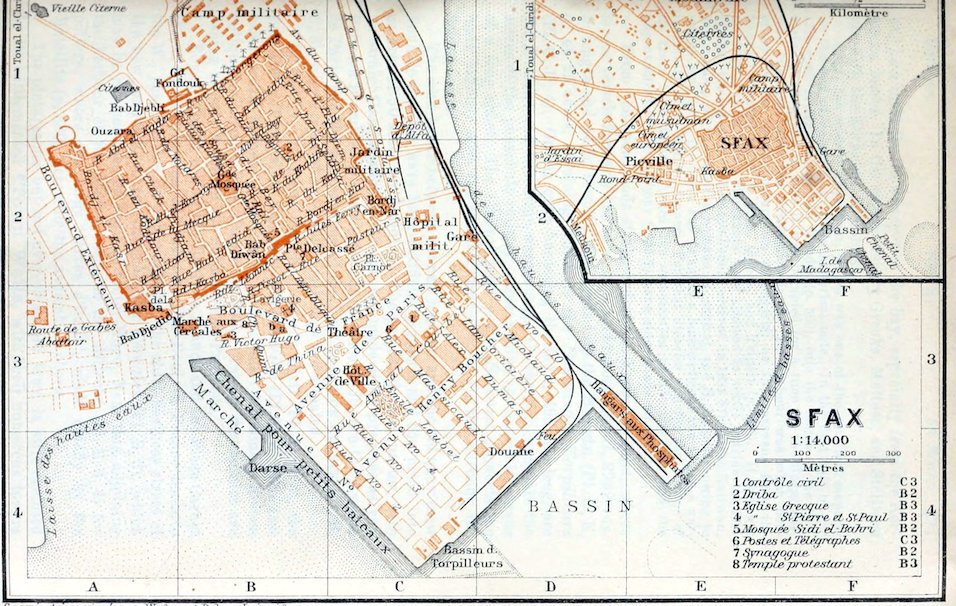
381Sfax, the ancient Taparura, which was one of the smallest seaports on the bay of Gabes, is of little historical note. In the first half of the 12th cent. it fell, along with Mehdia (p. 369), into the hands of the Normans (p. 323), and in 1539 it was occupied for a time by the Spaniards, who possessed also the Kerkenna Islands. Its harbour was much benefited by the French occupation of Algeria, as the caravans from the Sudan thereafter went to Sfax, Gabes, and Tripoli (p. 406). It was not till 1832 that Christian merchants were allowed to settle outside the Bâb Diwân, the sea-gate. When the French arrived in 1881 Sfax, like Kairwan, was a camp of the warlike nomads of central and S. Tunisia, owing to whose resistance the town had to suffer a bombardment and to pay a war-indemnity of 15 million francs. For that disaster and for the decline of its trade with inland Africa the colonization of the environs and the improvement of the harbour (1895–7) have since made amends.
From the open roads at the end of the Kerkenna inlet, where larger vessels formerly had to anchor, a Harbour Canal, 2952 yds. in length and 44 in breadth, now leads into the Bassin (Pl. D, E, 4) of 25 acres, adjoining which is the Bassin des Torpilleurs (Pl. C, D, 4). On the quay bordering the town, 492 yds. long, are the Douane and two large warehouses. On the N.E. quay are the stores of the phosphate railway, whence ships are loaded by means of a long shoot. The Chenal pour petits Bateaux connects the main harbour with the small Darse (Pl. B, 4), the harbour for fishing-boats.
The mud-banks between the new harbour and the old quay (now Boul. de France) have been artificially raised and converted into an area of 50 acres for building. The projected new quarter, with its straight and shadeless streets, has made little progress as yet. Between it and the older suburb, built since 1832, are the Avenue de Paris and the palm-avenue of the Boulevard de France (Pl. B, C, 3), where most of the public buildings are situated.
In the Ave. de Paris are the Contrôle Civil (Pl. 1; C, 3), the Post Office (Pl. 6; C, 3), and the Hôtel de Ville (Pl. C, 3). The last has a small museum (open daily except Sun.) containing Roman antiquities, mostly from Thænæ (p. 383). Among the mosaics are fishing scenes, Arion on the dolphin, and Pugilists.
Beyond the E. end of the Boul. de France and the Place Carnot (Pl. C, 2) lies the Jewish Quarter. The Boul. de France leads to the W., past the Rue de la République, the chief business street of the new quarters, to the Marché aux Céréales (Pl. B, 3), which may be reached also by the Rue Victor-Hugo. Near this, adjoining the harbour of the fishing-boats, is the Marché (Pl. B, 3, 4) for pottery, where the large ‘jarres d’huile’, made chiefly by the Metellits (p. 380), resemble the ancient amphoræ.
The picturesque but not over-clean old town is still enclosed by its battlemented *Town Walls, with their numerous towers 382and bastions. The fortifications next the sea, the Kasba (Pl. A, 3; barracks, no admittance) and the Bordj en-Nar (Pl. C, 2), were the chief objects of attack by the French ships and troops in 1881.
The old town is entered by the Bâb Djedid (Pl. A, 3), the Bâb Diwân (Pl. B, 2), at the end of the Rue de la République, and the new Porte Delcassé (Pl. B, 2; 1903). Its main streets are the Rue de la Grande-Mosquée, the shortest way to the Souks (see below), and the Rue du Bey (Pl. B, 2, 1).
In the Rue des Aïssaouas (No. 12), a few paces to the right of the Rue du Bey, is the Zaouïa Sidi ben-Aïssa (p. 373), with its fine portal. The castigations practised by the sect may be seen here on Fridays, from 2.30 to 5 p.m.
In the Rue de la Driba, the third street to the right off the Rue du Bey, No. 4, on the left, is the Driba (Pl. 2; B, 2), a fine type of an aristocratic mansion, with a picturesque colonnaded court on the first floor (fee ½ fr.). Opposite, at No. 5 Rue Régulus, one of the Portals has the geometric ornamentation so common in every part of the town.
At the end of the Rue de la Grande-Mosquée rises the venerable Chief Mosque (Pl. B, 2), with its square whitewashed minaret, whose upper half is of the 13th century. The main façade recalls Syrian types (Kalat Simân), and the ten arcades of the interior are like those of the Sidi Okba mosque (p. 374).
Just beyond the mosque are the Souks, or markets. Their centre is the vaulted Souk des Etoffes (Pl. B, 2), with a large assortment of ‘gadrouns’, the chief garment of the people of Sfax, blankets from Gafsa, etc. Its continuation, the Rue des Teinturiers, leads to the Bâb Djebli (Pl. A, 1), the picturesque N.W. gate.
To the right the town-wall is skirted by the Rue des Forgerons (Pl. B, 1), with its balconies. To the left, Rue Abd el-Kader 62, is the law-court of the Ouzara (Pl. A, 1; sits Wednesday and Saturday forenoons), with a pretty court.
Outside Bâb Djebli is the bustling cattle-market, enclosed by fondouks or caravanserais, where we have a pretty view of several saints’ tombs and palm-shaded gardens.
A pleasant glimpse of the country and its inhabitants is afforded by a drive to the Toual el-Chridi (tariff, see p. 380; but bargain advisable). Beyond the Bâb Djebli we pass the large Feskias, or rain-water reservoirs, and then numerous Nasrias or small cisterns. The *Orchard Zone extends about 5 M. inland. Passing through olive-groves and flanked with straight rows of trees the road ascends to the (13½ M.) Toual el-Chridi (433 ft.), a hill with a geometric signal, a kind of pyramid in steps, where we have an extensive view stretching to the sea.
On the road to Gabes (p. 389), beyond the S.W. suburb of Picville and the Rond-Point, is the Jardin Public, watered by large basins, with the Jardin d’Essai, or botanic garden.
In the sea, nearly 1 M. outside the harbour, is a Biological Station for the promotion of the sponge-culture (comp. p. 381).
From Sfax to Gafsa and Metlaoui, see R. 60; to Djerba, see R. 62; to Tunis by sea, see R. 64; to Tripoli and Malta, see R. 64.
383
60. From Sfax to Metlaoui viâ Gafsa.
151 M. Narrow Gauge Railway (Comp. des Phosphates et du Chemin de Fer de Gafsa), in 9¾–10¼ hrs. (27 fr. 20, 20 fr. 65, 14 fr. 60 c.); to Gafsa, 127 M., in 8–9 hrs. (22 fr. 95, 17 fr. 45, 12 fr. 30 c.; return-ticket, valid for 5 days, 32 fr. 15, 24 fr. 40, 17 fr. 20 c.). Railway Restaurant at Graïba only; it is advisable to take provisions.
Sfax, see p. 380. The train skirts the inland side of the town and then runs to the S.W., near the coast. To the left rises the lighthouse of Râs Tina (p. 405), near the ruins of Thaenae, once the chief harbour for the export of olive-oil from the interior.
18 M. Oued-Chaffar. 22½ M. Maharès (pop. 1000), a fishing village and market for the Mehadla Tribe, is the last fruit-tree oasis to the S.W. of Sfax. Above it rises an old fortified Bordj. On the left, close to the shore, near the Gabes road (R. 62), is seen the castle of Ounga, with its eight towers, which is said to have been built by the knights of Malta (p. 398).
Leaving the coast the train runs to the W., through an almost uninhabited sandy waste, to (39½ M.) Graïba (Rail. Restaurant), from which a diligence plies to Gabes (p. 389).
In the distance appears the bare S. Tunisian hill-country, with Jebel Bou-Hedma (2559 ft.). On the left lie the flats of the large Sebkha en-Nouaïl.
61 M. Mezzouna, at the N. base of Jebel Mezzouna (1329 ft.), where alfa abounds. 76½ M. Maknassi (hotel), a village of colonists, with olive-groves, and an important alfa station, lies in the Bled Maknassi, a monotonous plain on the N. spurs of Jebel Maknassi (1332 ft.). To the N.W. appears Jebel Majora (2871 ft.).
98 M. Sened (1575 ft.), the highest point on the line, with large alfa-stacks, is the station for Sened (1706 ft.), a village 5 M. to the S.E., on the olive-clad slope of Jebel Biadha (3248 ft.).
We now descend through cactus plantations, and in spring through corn-fields, to the Bled el-Hamra, a lofty plain to the N. of Jebel Oum el-Alleg (3839 ft.), in the territory of the great nomadic tribe of the Hamama. 110½ M. Aïn-Zannouch, the only station with good drinking-water. On the right are extensive dunes, formed by disintegration.
The train rounds Jebel Orbata (p. 385) and then enters the valley of the Oued Baïech.
127 M. Gafsa.—The Station (about 1000 ft.) lies on the left bank of the stream, 2¼ M. to the S.E. of the old town (diligence twice daily in ½ hr.).
Hotels. Hôtel de France, Place de la Kasba, R. 3–5, B. ¾, déj. or D. 3, pens. 8–10, omn. 1 fr., plain; Buffet-Hôtel, at the station.
Post & Telegraph Office, Place de la Poste.
Carriages (limited in number), 20–25 fr. per day; to Tebessa (p. 315) or to Kairwan (p. 372) 120 fr.—Diligence to Tebessa, see p. 318.—Horse or Mule (3–5 fr. per day), best obtained through the Contrôle Civil, where tickets for the mosques also are obtained.
384Gafsa (1067 ft.; pop. 4500, incl. about 1000 Jews and 360 Europeans), the ancient Capsa, is a peaceful little oasis-town, with two hot springs (88–91½° Fahr.) and several cold, rising in or near the river-bed. The old town lies on the edge of the plateau, on the right bank of the Oued Baïech, which almost everywhere else is dry. It has formed a valley about 3 M. broad, between Jebel Orbata (3839 ft.; p. 385), on the E., and the spurs of Jebel Bou-Ramli (3609 ft.) on the N.W., this being the only considerable pass between the S. Tunisian steppe and the shotts (p. 320). The town is sheltered by Jebel Ben-Younès (3002 ft.) and Jebel Assalah from the cold N.W. and N. winds, and like El-Kantara (p. 276) is a portal of the desert. Its mild climate and beautiful oasis render it a fine winter residence for persons of moderate requirements.
Capsa is said to be one of the oldest towns in the interior of Tunisia. Owing to its remote situation in the extreme southern part of his dominions Jugurtha (p. 321) made it one of his headquarters and his treasury; but one morning at dawn, after a nine days’ march from Lares (p. 360), so graphically described by Sallust, it was surprised by Marius and razed to the ground in 106. Under Augustus the town was still in ruins, yet in the 2nd cent. it vied with Thelepte (Feriana, p. 371) as one of the wealthiest towns in S. Tunisia. Through Capsa ran the important caravan-routes between Tebessa and Gabes, those to Feriana, Sbeïtla, and Susa, and viâ Tozeur to the Limes Tripolitanus (p. 412). With the exception of the Piscinæ (see below) all the Roman structures have been demolished for modern building purposes. The town-walls were rebuilt by Solomon (p. 315) in Justinian’s reign, and in the Moorish period were succeeded by a triple mud-built wall, of which scarcely a trace is left. The Byzantine citadel, built of Roman materials, was succeeded by the Moorish Kasba, which the French have now converted into barracks. Since the entry of the French troops in 1881 the mosques have been regarded as desecrated.
From the new Gafsa-Gare quarter a street leads to the Oued Baïech, crosses it, where native washerwomen and thirsty camels often present an entertaining scene, and ascends on the border of the oasis (p. 385) to the old town, dominated by groups of palm-trees and two minarets.
The large Champ de Foire and the Fondouk (p. 281), on the E. side of the town, are full of life when caravans arrive with their dates from the Djerid (p. 386). The corn-market in the Halle aux Grains also is of some importance.
From the Place du Marché (market on Wednesday), at the S. end of the Champ de Foire, the Rue du Gén.-Philebert leads through the town to the Place de la Kasba. Here, on the W. side, rises the Kasba, with its towers and white pinnacled walls, once the chief sight at Gafsa, but now the barracks of military convicts. View from the Poste Optique (adm. on application). The Jewish Quarter with its narrow streets, lies to the N.E. of the Place de la Kasba, on the N. side of the town.
The dilapidated Roman Piscinæ (Arabic Termid, from ‘thermæ’) are still used as baths. The Jewish Bath is fed by the Kasba 385spring. The largest basins, supplied by the hot spring outside the Kasba and chiefly used by the Moslems, are in the Dâr el-Bey, to the S.E. of the Place de la Kasba. The men’s bath (Termid er-Rayel), where the children love to dive for sou-pieces, is worth seeing. In the beautifully clear water tiny fish (Chromis, occurring also in the underground waters of the Sahara), little black snakes, and small tortoises disport themselves among the bathers.
A little to the S. of the Piscinæ are the Souks. Foremost among their wares are bright-coloured blankets (frechias), burnouses, and carpets (guétifs), mostly made by the Hamamas (p. 383).
The Sidi Yakûb Mosque (Grande Mosquée), to the S.W. of the Dâr el-Bey, one of the oldest in Tunisia, is noteworthy for its interior with nave and eighteen aisles, in the style of the Sidi Okba mosque at Kairwan (p. 374). The minaret, especially towards evening, affords a charming *View of the town and the oasis, and of the finely shaped hills and the yellow desert to the S.
The **Oasis, nearly 4 sq. M. in area, the richest and greenest palm-oasis in all Barbary, offers many delightful walks. Most of the paths conveniently overlook the little gardens lying below them, watered by numerous runlets from the Piscinæ.
In the shade of the palms grow apricots, peaches, figs, pomegranates, quinces, almonds, pears, and olives, and here and there oranges and lemons. The vine, with its vigorous and picturesque tendrils, climbs up the palm trees or the nettle-trees (Celtis australis) planted for its support, yielding ripe grapes as early as June. Below all these trees the soil is carpeted, in the cooler season, with vegetables, melons, wheat, and barley. The W. margin of the oasis, however, where water is scarce, yields olives only.
Fine points of view are the hill of Sidi Bou-Yahia, crowned with a kubba, on the N.W. margin of the oasis, the Ksour Nala, a spur of Jebel Ben-Younès, and, separated from the latter by the depression of the Foum el-Maza, Jebel Assalah, whence we survey also the steppe stretching to the N. to Jebel Sidi Aïch.
From Gafsa to Maâjen Bel-Abbès (Feriana), see p. 372; viâ Feriana to Tebessa, see p. 318.
A Road leads to the S.E. viâ the olive-oasis of El-Ksar to (3¾ M.) Leïla, a charming little palm-oasis; then, aside from the Sebkha d’el-Guettar, to (12½ M.) El-Guettar (952 ft.; two caravanserais; pop. 1800), a palm and olive oasis at the S. base of Jebel Orbata (3839 ft.; fine view from the Poste Optique; ascent by bridle-path 2½–3 hrs.). The route from El-Guettar to (83 M.) Gabes (p. 389), leading almost all the way through an arid wilderness, is fit only for those who are used to fatigue and privations. (Poor quarters at Bir Saâd and El-Haffey only.)
Beyond Gafsa the train crosses the Oued Baïech and beyond the oasis it enters the sandy and stony waste between the salt-marsh Garaet el-Oglal (on the right) and the chain of Jebel Rosfa (1411 ft.) and Jebel Jellabia (1346 ft.; to the S.). Beyond the dry bed of the Oued Melah the long range of Jebel Tarfaoui (p. 388) appears far to the left.
386We skirt the S. base of Jebel Stah (2953 ft.), Jebel Tarfai (2166 ft.), and Jebel Metlaoui (1805 ft.), all rich in phosphates. These hills, overgrown with alfa-grass only, are, like those near Gafsa, a favourite haunt of the gazelle; the maned sheep (p. 277) also occurs.
151 M. Metlaoui (643 ft.; Hôt. Rey, R., déj., D., 3 fr. each, quite good), Arabic Metlâwi, on the S. slope of Jebel Seldja, not far from the Oued Seldja (p. 372), lies in the heart of the S. Tunisian phosphate-region, which extends to Redeyef (p. 372), to Aïn-Moularès (p. 372), and to Jebel Mrata on the Algerian frontier. The phosphate is detached from the hill-sides by blasting (foudroyage) and then spread out to dry on the ground, where it is turned over several times by ploughs. The works employ about 5000 hands, mostly Italians and natives, and yield about 800,000 tons per annum. Adm. to the ‘Grande Recette’ of the works by leave of M. Bursaux, the manager.
Interesting walk or drive to the (3 M.) *Gorges du Seldja, a wild rocky defile (about 4½ M. long) between Jebel Seldja and Jebel Alima (2559 ft.).
For the new railways to Henchir Souatir, Redeyef, and Aïn-Moularès, see p. 372.
61. From Metlaoui to the Djerid.
Road viâ (35½ M.) Tozeur to (51 M.) Nefta (railway to the former under construction). A carriage may be hired at one of the inns at Metlaoui, but as the road is bad a mule is preferable. It is best to ride direct to Tozeur (carrying provisions, wine, etc.). Nefta may be visited from Tozeur, El-Oudiane best on the way back from Tozeur to Metlaoui (early start required).
The *Djerid (Arabic Belad el-Jerid), the narrow isthmus between the Chott Djérid (65–80 ft. above the sea), the largest salt-marsh in Barbary, and the Chott Rharsa (65 ft. below sea-level), with its four picturesque oases of Tozeur, Nefta, El-Oudiane, and El-Hamma (du Djérid), is the largest date-palm region in N. Africa. The number of palm-trees is estimated at about a million, but nearly half belong to the ‘hakhana’, an unfruitful species. The yield of dates is 12½–15,000 tons annually, of which 500 tons only are of the transparent variety. They are exported chiefly viâ Gafsa and Sfax. The mildness of the climate (p. 321) adapts Tozeur in particular for winter residence, but malaria is prevalent in summer. The population (about 30,000), which is said to have included scattered remnants of Christian communities down to the 18th cent., is chiefly of Berber origin, but with the Arab nature fully developed.
Metlaoui, see above. The road leads to the S.W., through an almost bare waste, at first near the left bank of the Seldja and then down its dry bed.
15½ M. Bordj Gouïfla (269 ft.; no drinking-water), a deserted caravanserai, lies at the junction of the Gafsa road, beyond the influx of the Oued Seldja into the Oued Melah (p. 387). We then skirt the spurs of Jebel Tarfaoui (p. 388). The road to El-Oudiane (p. 388) branches to the left.
387Not far from the delta of the Oued Melah we near the Chott Rharsa, which in the hot season is reduced to a few streamlets and pools, and next reach the E. border of (30 M.) the oasis of El-Hamma du Djérid (164 ft.; Bordj, quarters 1 fr.). This oasis, the smallest in the Djerid, with 900 inhab., about 54,000 palms, and a few olive-trees, has of late had mud-walls (tabias) built to shelter it from sand-drift. The Hammâm, a piscina in a kind of palm-hut, whose water (109° Fahr.) is in high favour with the natives, is of Roman origin.
The road crosses the (32½ M.) downs of Drah Tozeur or Drâht en-Nadour (269 ft.), and reveals a striking *View of the green oasis of Tozeur and the glittering surface of the Chott Djérid.
35½ M. Tozeur (197 ft.; Hôt. Bellevue, R. 3, B. ½, déj. or D. 3 fr., unpretending, with attentive landlady; pop. 10,000, incl. 65 Europeans), the ancient Tusuros, Arabic Tûzer, is the seat of the authorities of the Djerid. The houses, mostly one-storied, built of crude (tobs) and burned bricks, have a peculiar geometric ornamentation in brick network, which differentiates them from most of those in the other oases. The Souks are less important than those of Nefta (see below). Interesting *Views are obtained from the minarets of the Zaouïa Sidi Abid and the new Sidi Mouldi Mosque (tickets at the Contrôle Civil).
The *Oasis, which is hardly inferior to that of Gafsa in richness and variety of vegetation (p. 385), contains about 420,000 palms. Several hours may be pleasantly spent in riding to the chief points of interest. Leaving the town we ride to the W., viâ Chabia village, with its curious huts of palm-logs, to the Râs el-Aïoun, where 194 springs unite to form the Oued el-Mechta. We then skirt the S.W. border of the oasis and descend viâ the villages of Zaouïet-Sahraoui, Djehim or Djem, and Abbas or Abbès to the kubba of Sidi Ali Bou-Lifa, near the shott, with a huge and venerable lotus-tree. Thence we should return to Djehim and ride to Bled el-Adhar, a village in the W. half of the oasis. The interesting mosque here, the oldest in the Djerid, stands on the site of a Roman temple, which is said to have been converted into a Christian basilica. The *Mihrâb, or prayer-niche, unfortunately whitewashed, dating from 1194, is most elegantly decorated in stucco. We return thence to Tozeur, where the half-dead lotus-tree and the little mosques present a picturesque bit of scenery.
A Road, with fine points of view, leads from Tozeur to the W., viâ Chabia (see above) and along the S. margin of the dunes of Koudiat Oum el-Arouah (558 ft.), to (51 M.) Nefta (200–300 ft.; Djerid Hotel, R. 3–4, B. 1, déj. or D. 3–4, pens. 8–10 fr., quite good; carr. at the Khalifa’s only; pop. 14,000, incl. many Jews but only a few Europeans), the Roman Aggarsel Nepte. The houses resemble those of Tozeur in style, but blocks of gypsum from the vicinity also have been used as building-material. We are struck with the great number of small mosques and zaouïas, among which is the zaouïa of the Kadria (p. 361), the most important in S. Tunisia and a religious house of the Rahmania order. The souks, which are much patronized by the Sahara caravans, offer all the 388products of the Djerid, such as white frechias (p. 385), burnouses (‘djeridi’), silk haiks, etc.
Before riding through the *Oasis (2–3 hrs.; mule with guide 3–4 fr.), the finest in the Djerid, with its 187,000 palms, we proceed from the souks to the so-called *Corbeille (Arabic Kasr el-Aïn, ‘castle of the springs’), a grand gorge in the middle of the town, where the copious springs (152, it is said) unite to form a brook. We then ride to the N.W., past the Zaouïa of the Kadria (p. 387) and along the mud-walls (p. 387), to the Parcelle Forestière (fine view), or to the Poste Douanier, another good point of view. We then return, past the mosque of Sidi Merzoug and the palm-garden of Ghitane ech-Chorfa, to the Barrage, a Roman dam below the Corbeille (at the weir, a little lower, good bathing-place), and visit the elegant kubba of Sidi Bou-Ali, in the heart of the oasis.
El-Oudiane, the eastmost oasis of the Djerid, with 6000 inhab. distributed among six villages, lies 6¼ M. to the N.E. of Tozeur and 3 M. to the E. of El-Hamma (p. 387), on the slope of Jebel Bou-Hellal (624 ft.), the W. offshoot of Jebel Tarfaoui (1821 ft.). This oasis, 4½ M. long, watered by a number of small springs, possesses about 185,000 palms and 25,000 olive-trees, while numerous orange and lemon trees add a special charm. The chief village is Deggach (180 ft.; pop. 3000), built partly of stone. Thence we ride past Zaouïet el-Arab, with its minaret (fine view), and Kriz, on the slope of Jebel Nadour (519 ft.), to the walled village of Cedadda (230 ft.). At Guebba, a village adjoining Kriz, close to the shott, are some Roman ruins.
The Trik el-Oudiania, a caravan route once used by the Romans but sometimes impassable after heavy winter rains, leads from Kriz across the Chott Djérid, to the S.E., to the Caïdat du Nefzaoua, a part of the S. Territories (p. 390) between the shott and the Erg Oriental (p. 285). The first oasis beyond the salt-marshes is (30½ M.) Debabcha, on the peninsula of that name. 43 M. Telmine, the ancient Turris Tamaleni, was the westmost frontier-fortress on the Limes Tripolitanus (p. 412). 47 M. Kebilli (quarters in the Bordj), the ancient Vepillium (?), is now the chief town in the Nefzaoua, with 5000 inhab., a market well attended by the Sahara caravans, and the finest palm-oasis in this region.
Roads lead from Kebilli: (1) To the N.E., through the waterless sandy waste between the Chott el-Fedjedj (p. 389) and Jebel Tebaga (1608 ft.) and past (9½ M.) Limagues and (34½ M.) Oglet Nakhla, to (53 M.) El-Hamma (quarters at the Bordj), the ancient Aquae Tacapitanae, with hot springs (118° Fahr.) and a charming palm-oasis; then past the S. base of Jebel Dissa (492 ft.; Poste Optique) to (74 M.) Gabes (p. 389).—(2) To the S.E., through the desert on the S. side of Jebel Tebaga (see above), past Henchir Bou-Garfa and Tamezred, to (about 68 M.) Matmata-Kebira (p. 391).
62. From (Sfax) Graïba to Djerba viâ Gabes and Médenine.
High Road from Graïba viâ (52 M.) Gabes to (101 M.) Médenine. Diligence to Gabes, in 9 hrs. (starting at 11.30 p.m., returning at 5.15 p.m.); thence to Médenine, in 8 hrs. Roads from Médenine to the two starting-points for the island of Djerba: one viâ (37½ M.) Zarzis to (52 M.) Marsa el-Kantara; the other viâ (17½ M.) Djorf Bou-Grara to (30 M.) Marsa el-Adjim.—Roads from El-Kantara (15½ M.) and El-Adjim (14 M.) to Houmt-Souk.
389A motor-car should be hired from Sfax (p. 380) to Médenine, or all the way to Marsa el-Kantara. Or we may drive thither from Graïba, by carr. previously ordered from Gabes. At Médenine it is advisable to telegraph to Houmt-Souk for a carr. to meet the traveller at El-Kantara (or El-Adjim, as the case may be).—Houmt-Souk is a steamboat-station between Tunis and Tripoli (comp. R. 64).
From Sfax to Graïba (39½ M.; railway in ca. 2 hrs.; fares 7 fr. 5, 5 fr. 35, 3 fr. 80 c.), see p. 383.
The Road leads to the S. from Graïba to (5½ M.) Archichina, a caravanserai on the W. side of the Sour Kenis Bay, where we join the main road from Sfax. It then traverses a desolate sandy waste on the W. side of the Gulf of Gabes (p. 405), inland from the little seaport Skira (for the alfa trade).
On the (28 M.) Oued Akarit we enter the province of Arad. Between Jebel Roumana (564 ft.) and Jebel Dissa (p. 388), offshoots of the hills around the shott region, extends the flat Isthmus of Gabes, 12½ M. broad, bridging the space between the bay and the Chott el-Fedjedj (76 ft. above sea-level), the E. continuation of the Chott Djérid (p. 386). In 1873 Ferd. de Lesseps (p. 437) suggested that, by cutting a canal through the isthmus, the whole of the shotts, as far as the Chott Melrir (p. 284), might be converted into a great inland sea; but several of them lie much above the sea-level.
34 M. Domaine de Oued-Melah, an olive and palm oasis (10,000 palms), on a brook generally dry, is partly watered by the oldest artesian wells in Tunisia (1885).
To the right, a little off the road to Gafsa (p. 383), lie the palm-oases of Oudref and El-Methouia, and to the left Ghennouch. Near the (49½ M.) poor oasis of Bou-Chemma we join the road from Kebilli (p. 388).
Our road leads through the palm-oasis of Gabes (p. 390) and past Djara (p. 390) to (52 M.) Gabès-Port.
Gabes.—Arrival by Sea (comp. R. 64). The steamers anchor in the open roads (at low-tide over ½ M. from the fishing-boat harbour). Landing or embarking, especially in summer, in N.E. or E. wind, is often impossible.
Hotels (comp. p. 324; sometimes crowded with motorists in spring). Grand-Hôtel, Hôt. des Voyageurs, both at Gabès-Port, ½ M. from the pier.
Cab from the pier to Gabès-Port 40 c. (for several pers. 20 c. each); one hour 1½ fr., each addit. ¼ hr. 25 c.; day of 10 hrs. 10–12 fr.; carr. and four horses, for long excursions, 20 fr. a day.
British Consular Agent, C. Calleja.
Gabes or Gabès (Europ. pop. 900, mostly Italians and Maltese; total, incl. oasis, 10,200), the ancient Tacape, the chief harbour on the stretch of coast called Emporia by the Greeks and a rival of Leptis Magna and Tripoli (comp. p. 407), is now the capital of the 390Arad and headquarters for the S. Territories, which are still under military rule. It is the only harbour of importance on the S. coast of the Gulf of Gabes (p. 405). The chief exports are the sponges of the bay, alfa or esparto grass, dates, and woollen goods. In the war annals of 1881 the bombardment of Gabes from Menzel (see below) and the protracted resistance of the inland tribes are memorable. It was here that Gen. Logerot intercepted the tribes of the E. coast who tried to pass through the Arad to Tripolitania.
The small Harbour, for fishing-boats only, at the mouth of the Oued Gabes, protected by two stone piers, is exposed to every wind and choked with sand.
To the N.W. of the estuary, on the border of the oasis, which is here protected from sand-drift by palisades, rise low dunes; to the S.E., near the lighthouse, is an admirable bathing-beach.
The modern Gabès-Port, adjoining the Camp Militaire, contains no attraction except the garden of the Cercle Militaire. It is garrisoned with 160 native horsemen (Spahis or Cavaliers du Maghzen), who guard the Tripolitanian frontier of the S. Territories. The tradespeople are mostly Jews.
Beyond Gabès-Port, also on the barren right bank of the river, lie the large Berber villages, partly built of Roman materials, of Djara (Grand-Djara; pop. 3500) and Menzel (pop. 4500, incl. about 1000 Jews). The market-place of Djara, a square enclosed by primitive arcades with shops, is frequented chiefly by the S. Algerian caravans.
Almost the only sight of Gabes is the beautiful, but in summer malarious *Oasis, once somewhat over-praised by Pliny, which extends 3¾ M. up the left bank of the river and is 1–1¼ M. in breadth. Among the remarkably tall and well-grown date-palms (about 200,000) are many bananas and other fruit-trees. The river and the small channels, often enlivened by women washing or carrying water, are crossed by numerous bridges of palm-logs. A walk or ride to the most interesting spots takes 3–4 hrs. (mule 2–3 fr.). From Menzel we go upstream to the Barrage du Sidi el-Bey (1894), and past the remains of a Roman Dam, built of huge blocks, to the Râs el-Oued (213 ft.), a hill at the W. end of the oasis often covered with clouds of dust, where the principal feeders of the river, 30 in all, form a number of waterfalls. Turning here, we follow the largest irrigation-conduit to the village of Chenini (pop. 1000) and cross the Sfax road (p. 382) to the N.W. half of the oasis, where many of the palms are overgrown with vines.
The *Monts des Ksour (p. 320), bordering the Sahara on the S. side of the Arad, are well worth visiting from Gabes or from Médenine (p. 391; carr. tariff, see p. 389; an ample supply of food and rugs advisable; comp. also p. 278). These barren hills culminate in Kef Toudjane (p. 391), which is almost everywhere conspicuous from the coast, and Jebel Smerten (each about 2100 ft.), and in Kef Demeur or Jebel Demmer (2460 ft.). 391The inhabitants, the Troglodytes of antiquity (see p. 320), are, in the N.W. part, the Matmatas, on the plateau of that name, and, in the S., members of the Ouerghamma League, Berber tribes which for centuries withstood the attacks of the Arabs and the predatory Sahara nomads. They still often live in caverns, with a court resembling a shaft as the centre of their dwelling, and cavities used as side-rooms or offices. The gardens, laboriously irrigated by dams and cisterns, yield olives, dates, and figs; in the valleys grain, chiefly barley, and vegetables are cultivated. The Matmatas often go to Tunis as porters or artisans but always return home in their old age.
A glimpse of this region is obtained by driving from Gabes to (28 M.) Matmata-Kebira or Kalaâ-Matmata (1838 ft.; p. 388; quarters at the Kaïd’s), on the Matmata plateau, whence an excursion (on mule-back) should, if possible, be taken to the picturesque rock-village of Hadege. A new but very hilly road leads from Matmata-Kebira through the mountains viâ (12½ M.) Toudjane (919 ft.), a village grandly situated on the slopes of Kef Toudjane (2090 ft.), direct to (37½ M.) Métameur (see below).
The Médenine Road (diligence, see p. 388) now leads to the S.E. through a steppe-like hill-country, fringing the Monts des Ksour (p. 390) and intersected by many valleys, passing the small oases of Menara (200 ft.) and (55 M.) Teboulbou (artesian wells; much olive-culture). Next come the valleys of the Oued Merzig and Oued Ferd, with the small oasis of (56 M.) Ketena.
74 M. Mareth (Bordj), a large palm-oasis on the Oued Mareth. We then cross the Oued Zigraou to (77 M.) Aram. Beyond the spurs of Jebel Touati and Jebel Souinia rises the main range of the Monts des Ksour (p. 390).
Beyond the valleys of the Oued Zeus and Oued Hallouf the road rounds Jebel Tadjera (968 ft.; Poste Optique). 97½ M. Métameur, formerly a ‘camp militaire’, on the brook of that name, below the small oasis and (½ hr.) Berber village of Ksar Métameur (391 ft.), whose storehouses (rhorfas), with keel-arched vaulting, recall very ancient buildings in Asia Minor.
101 M. Médenine (361 ft.; Médenine Hôtel, R. 2½, B. ½, déj. 2½ fr., good; pop. 1000, incl. 100 Europeans), capital of the Ouerghamma (see above), the league of the Berber tribes Khezour, Touazine, Ouderna, and Accara. The high-lying Camp Militaire, with its garrison of Spahis (p. 390) and Infanterie Légère d’Afrique (‘Joyeux’), is the largest on the Tripolitanian frontier.
The deserted and ruinous *Ksar, in a small palm-oasis, consists of a great number of the old storehouses of the League, some of them in four or five stories, now replaced by retbas or rabtas (p. 338). They are dug deeply in the hill-side, and are accessible only by stairs of mud or stepping-stones.
Travellers used to privations and content with such poor quarters as the natives can offer may, after consulting the military authorities at Médenine, visit the S. part of the Monts des Ksour (p. 390). The best centre there is (34 M.) Tatahouine, the seat of the military and civil 392authorities, with an important market, well attended by caravans on their way from the Sahara and the Sudan by way of Ghadâmes in Tripolitania (p. 285). The chief villages of the cave-dwellers (Ksûr) near this are Tlalet, formerly Talalati, a frontier-fortress on the Limes Tripolitanus (p. 412), Beni-Barca, *Chenini, and *Douirat (2090 ft.).
The Zarzis Road (37½ M.) descends to the E. from Médenine through the sandy coast-plain to (15½ M.) Aïn-Mader, near the saline marshes of that name on the S. bank of the Mer de Bou-Grara (see below), and then traverses the hill-region of the Accara tribe (p. 391), between the sea and the large Sebkha el-Melah.
To the left, a little off the road, 4 M. from Zarzis, are the ruins of the little Roman town of Zita, now Zian, where the small forum is still enclosed with the remains of its colonnade.
37½ M. (or from Graïba 138½ M.) Zarzis (accommodation at the Bordj), on the site of the Roman seaport Gergis, amidst extensive olive-groves famed for their oil, has two artesian wells and a small harbour for fishing-boats. Important sponge-fishery.
A road (the chief route to the island of Djerba) leads to the N.W. from Zarzis across the Péninsule de Zarzis or des Accara to (14½ M., or, from Graïba, 153 M.) Marsa el-Kantara, a village near the Râs Marmor, on the S. side of the E. entrance (1¼ M. wide) to the Mer de Bou-Grara (see below). The dilapidated Roman dam which crosses the strait here to El-Kantara is still used by camel-caravans at low tide (6½ ft. below high-water), but it is better to cross by fishing-boat. From El-Kantara to Houmt-Souk, see p. 394.
The Djorf Bou-Grara Route to Djerba is shorter (30 M.) and will repay antiquarians. The rough road (mule preferable to carr.) leads from Médenine to the N.E. viâ Bir Saâdou, and then past some small salt-marshes, to the Mer de Bou-Grara, a large landlocked bay between the mainland and the island of Djerba, accessible for large vessels by the Canal d’Adjim only (not quite 1 M. across; see p. 393). This bay, in which fish abound, and Lake Bizerta (p. 352) are the best natural harbours in Tunisia.
17½ M. (or from Graïba 118½ M.) Djorf Bou-Grara (no inn) is near the site of *Gightis, a small Punic-Roman seaport, which attained great prosperity in the 2nd cent. A.D. The harbour, which was always shallow at low tide, is now entirely silted up. Excavations begun in 1896 have revealed the ruins of curiously cramped and irregular streets, with various public buildings, villas remarkable for their coloured incrustation and rich mosaics, and Byzantine houses built of Roman materials.
A broad street ascends from the harbour to the Macellum, with fountain and exedra similar to those at Timgad (p. 295). The small Forum, 60 by 44 yds., has on the E. side an archway, the Curia, and the Market Basilica, with the tribunal, while the Severus Arch on the N. side formed a lateral entrance. On the S. side rises the Capitol (see p. 288), in the style of the capitol or ‘Jupiter temple’ at Pompeii.
393The Temple of Mercury, to the S. of the forum, has columns in its peribolos, or outer wall, with curious capitals adorned with cables, in allusion to the occupation of the founder. The building is curiously planned, having several small rooms or ‘sacristies’ behind the cella; it is adjoined by a chapel of Mercury and one of Minerva.
A Temple of Isis (?), a Temple of Hygiea, the Thermae, and a late-Punic Cemetery also have been unearthed.
If a fishing-boat is available at Djorf Bou-Grara we may sail direct to Adjim (p. 394; 13½ M. in ca. 1½ hr.). If not, we must go 12½ M. farther to (30 M., or from Graïba, 131 M.) Marsa el-Adjim at the Râs el-Djorf, the N. point of the peninsula, opposite Adjim (1⅓ M. distant; boat in ¼ hr.).
The Island of Djerba (highest point 118 ft.), 17½ by 14 M., is the largest on the N. African coast. From the lotus-tree (Zizyphus Lotus; Arabic nebga, Fr. jujubier), which thrives here, Homer called it the island of the Lotophagi. It was later named Meninx and was the birthplace of the Roman emperors Vibius Gallus and Volusianus (251–3). It is now one of the most fertile and prosperous regions in Tunisia. Secure in their insularity against the attacks of the nomadic Arabs, the inhabitants (about 40,000), mostly Berbers of the Kharijite sect (p. 323), have retained their old language and customs. They vie in industry with their kinsmen the Mozabites (p. 216) and go forth as traders to all the seaports of the Orient. Agriculture also thrives. There are 1,300,000 date-palms, 500,000 olive-trees, and as many orange, lemon, and peach trees; early vegetables too are now largely grown. The sponge, polypus, and other fisheries and the oyster-beds in the Canal d’Adjim (p. 392) are very productive.
Djerba has four harbours, Houmt-Souk, Adjim, El-Kantara, and Aghir. The only towns are Houmt-Souk, Hara-Kebîra, and Hara-Serîra; the villages are merely local markets for their districts. The countless little mosques have white domes like most of the houses, but are distinguished by conspicuous slender minarets of the Turkish type, resembling lighthouses. The farm-houses (menzel) scattered throughout the island often have a castellated appearance. In the entire absence of brooks the soil is irrigated from cisterns and wells, among which are two very copious artesian wells. The winter climate (p. 321) is the mildest in Tunisia, but gales are frequent. For excursions there are few carriages available (20 fr. per day); the usual conveyance is an araba or country-cart; for a mule the charge is 4–5, for a donkey 3 fr. per day. The tourist should beware of the countless scorpions, especially in the warmer season.
Houmt-Souk (Hôt. de l’Oasis or Crolet; Hôt. de France; Brit. cons. agent; pop. 5900, incl. 560 Maltese, French, Italians, and Greeks), the capital of the island, lies on the sandy N. coast, ½ M. 394from the sea and 5 M. from the anchorage of the steamers (comp. p. 405). The dilapidated Bordj el-Kebîr on the shore recalls the time of the Spanish domination. Near it is the Christian Cemetery, where repose the bones, collected in 1848, of the 18,000 Spaniards who were massacred here in 1560 after the naval victory of Dragut (p. 370) and Ochiali Pasha, and yielded trophies for the ghastly Bordj er-Rious (tower of skulls).
In the interesting Souks (Mon. and Thurs.) are seen all the products of the island. Among the numerous religious buildings may be named the Mosquée el-Gheriba and the Mosquée des Turcs.
A road leads to the S. from Houmt-Souk to the Jewish villages of (¾ M.) Hara-Kebîra (pop. 3500) and (4½ M.) Hara-Serîra or Hara-Sghîra (pop. 1500), where numerous goldsmiths make silver-gilt trinkets of antique and Byzantine patterns, with enamel and jewels (mostly imitation). The Gheriba, the synagogue of Hara-Serîra, where, according to an old tradition, one of the tables of the law of Moses was once found, is a great resort of Jewish pilgrims from S. Tunisia and Tripolitania, and is much revered by Moslems and Catholics also.—From Hara-Serîra the road leads to the S. to (14½ M.) Guallala, the centre of the pottery-manufacture carried on in Djerba ever since ancient times (oil-jars, porous water-jugs, vases, etc.). Near it is the hill of Dahrat-Guallala, which yields the clay.
A road leads to the S.E. from Houmt-Souk viâ Hara-Kebîra (see above) and (10⅓ M.) Cedouikeche (potteries) to (15½ M.) El-Kantara, the seaport for Zarzis (p. 392), not far from the extensive but unimportant ruins of Meninx, the ancient capital of the island.—Another road leads to the S.W. to (14 M.) Adjim, a rising little seaport and market (Wed.), with an artesian well 760 ft. deep. To Djorf Bou-Grara (and Gightis), see p. 392.
Near the E. coast of the island, on the roads to the Râs Taguermess (p. 406) and the small summer harbour of Aghir, lie the villages of Midoune (Frid. market) and Mahboubine, with many villas of the merchants of Houmt-Souk, situated amid palm and olive groves and charming *Fruit Gardens, where the oranges and lemons blossom in March. On the road to Midoune is the Mausolée de Borgho, the only intact Roman monument in the island.
395