II. MADEIRA AND THE CANARY ISLANDS. (continued 2)
Reading edition
The ascent of the *Pico de Vandama (1838 ft.) may be made from Atalaya or direct from Santa Brígida (there and back 2 hrs.; mule 3 p.). This hill, overgrown with pines and tree-like broom, overlooks the grand mountain landscape of the E. coast. Very striking is the view of the *Caldera de Vandama, a huge crater-basin of about 550 yds. in diameter and 683 ft. in depth. Its floor is planted with vines and cereals, and it is worth while to ride down into it.
The Carretera del Centro leads, beyond the bifurcation for Atalaya, to (13 M.) the little town of San Mateo (2575 ft.; fair inn), superbly situated among the mountains. Rough mule-tracks lead thence to the Pico de las Nieves (6400 ft.), to the village of Tejeda (3160 ft.) in the *Barranco de Tejeda (p. 43), and to the cave-village of Artenara.
Scarcely less attractive than the Monte road is the *Carretera del Sur, which leads from Las Palmas, at first passing the cemeteries, then skirting the rocks of the E. coast, and at length turning inland, piercing the lava-rock by a tunnel, to Ginámar and (8 M.) Telde (394 ft.; inn; pop. 4000), a picturesque little town amidst beautiful orange-groves.
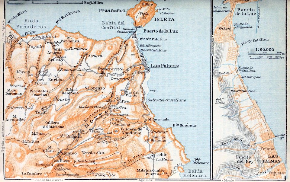
47The Carretera del Norte, crossing the Barranco de San Lorenzo and the road from Puerto de la Luz (p. 43) at Tamaraceite, and farther on, beyond a long tunnel, the Barranco de Tenoya above the village of that name, leads to (10 M.) Arucas (1017 ft.; two inns), an industrial little town of 2900 inhab., at the foot of the Montaña de Arucas, a hill affording fine views. The sugar-cane is cultivated in the vicinity.
A by-road diverges from this carretera, beyond the Barranco de San Lorenzo, to (12½ M.) Teror (1936 ft.; dirty inn), a little town with the famous pilgrimage-church of the Virgen del Pino (16th cent.).
The island of Palma, or La Palma, in the extreme N.W. of the archipelago, 28½ M. long and 17 M. broad, lying about 16½ M. to the W. of Teneriffe, is remarkable for its fine scenery and superb forests, but is as yet rarely visited by tourists. The famous Caldera, the largest and deepest of all the crater-basins in the islands, opens towards the W. in the huge Barranco de las Angustias, while many smaller gorges render the N. coast in particular very difficult of access. The whole of the S. part of the island is of recent volcanic origin and therefore poorly watered. The population (42,000, in an area of 280 sq. M.) is confined to the S.E. margin of the island and the middle of the W. slopes Many of the natives emigrate, especially to Cuba.
Starting from Santa Cruz de Tenerife (p. 33) the steamer rounds the Anaga Mts., with the lighthouse already named (p. 33), and steers to the W. from the Punta del Hidalgo (p. 37) to Palma. The lighthouse on the Punta de Teno (23 ft.), the N.W. point of Teneriffe, remains visible for some time. The bold coast of Palma presents a grand appearance as we approach.
Santa Cruz de la Palma.—Hotels. Hot. Miramar; Hot. Español; Hot. Internacional; Fonda Verbena, pens. 4–5 p.—Carriage to Los Llanos 45 p. (also motor-omnibus).—Mule per day 5–6, to Los Llanos 7½ p.
Santa Cruz de la Palma, the only considerable port (5700 inhab.) in the island, lies on the E. coast, on an open bay which is much exposed to sand-drifts. The houses rise in terraces on the steep hill-side, overtopped by tall Canary palms. The chief export is tobacco, which is little inferior to that of Havana. Cigar-factory of J. Cabrera Martín.
The main street, in which rises the Town Hall (Ayuntamiento) of 1563, leads to a picturesque triangular plaza with the church of San Salvador and several handsome houses. Close by is the small Museum (Museo de Historia Natural y Etnográfico). A beautiful palm-avenue leads through the upper part of the town.
Excursions. To the N.W. we may ascend through the Barranco de la Madera, with its cave-dwellings (Cuevas de los Guanches) to the loftily situated pilgrimage-church of the Virgen de las Nieves (16th cent.); 48thence either to the Montaña de Tagoje (about 3300 ft.; with grand view of the E. coast, of Gomera and Teneriffe), or to the Pico del Cedro (7471 ft.) on the E. margin of the Caldera (see below), round which we may ride to the Roque de los Muchachos (7693 ft.) on the N. side.—To the S.W., following the old bridle-path which cuts off the windings of the road, we may walk or ride to (1 hr.) Buena Vista (about 660 ft.), whence a rough mule-track ascends to the (2 hrs.) Cumbre Nueva (4593 ft.), the chief mountain-pass in the island, where we have a grand *View of the abrupt rocks and the pine-woods of the central chain, of the fertile plains to the W., and of the distant Peak of Teneriffe. Then we proceed through pine-forest, past the venerable ‘Pino de la Virgen’, to El Paso (2060 ft.; inn), whence we may ascend the Cumbrecita (4445 ft.) and the Idafe, the sacred mount of the Guanches, on the S. margin of the Caldera. Finally we descend to the (3 hrs.) little town of Los Llanos (1000 ft.; poor inn, bargaining advisable). From Los Llanos it takes a day (7–8 hrs., there and back) to visit the *Caldera, a vast basin, nearly 5900 ft. deep and 3–4½ M. in diameter, situated in the heart of the island and rarely quite cloudless. A tedious ride up the Barranco de las Angustias brings us to the farm-building of Tenera (3642 ft.), whence we look down on the floor of the Caldera, which is partly clothed with pines. The best way to return from Los Llanos to Santa Cruz is to drive (34½ M.) by the road passing Las Manchas, Fuencaliente (2297 ft.), Mazo (1312 ft.), and Breña Baja; or we may ride across the Cumbre Vieja (6660 ft.), the pass between Las Manchas and the Barranco Aduares.
49