VI. ALGERIA. (continued 5)
Reading edition
Jebel Maouya Gorah, the E. spur of Jebel Matraf, is a good standpoint for surveying the girdle of oases formed by the Zab Dahraoui and Zab Guebli (p. 280), stretching to the distant Oued Djedi (p. 284). The S. base of this range, where the building and paving stones of Biskra are now quarried, is skirted by the Route des Zibans, much used by caravans.
The Excursion to Sidi-Okba (13 M.; diligence, see p. 279; carr. tariff, see p. 279, but 12–15 fr. is usually accepted) is the favourite among the longer trips from Biskra. The Route de Sidi-Okba (Pl. C, 4, 5) fords the Biskra (sometimes dangerous after winter rains) and skirts the small oases of Lalia and Filliache. Between these is the Nécropole, once a Berber burial-ground.
For the long drive through the dreary steppe at the S. foot of the Aurès Mts., enlivened only by the begging children of the nomads, we are repaid by the verdant Palm Oasis of Sidi-Okba, the most fertile of the Zab Chergui group (p. 280), watered by a network of conduits from the Oued el-Abiod (p. 278).
The small town of Sidi-Okba (144 ft.; restaurant, at the entrance to the town; pop. 4900), the religious centre of the Zab, owes its origin and its fame as a resort of pilgrims to the tomb of Sidi Okba (p. 322), who ended his victorious career in the adjacent oasis of Thouda. The now poor town, with its mud-built fortifications and houses, and its beggars, lepers, and importunate guides, vividly recalls a mediæval Sahara town.
On alighting we walk straight on, then bear to the left, and soon reach a small square with the Maison du Kaïd and other picturesque houses. Turning here to the left we come to a second place, where on the left, preceded by a colonnade, rises the plain Mosque of Sidi-Okba, the oldest in Algeria, containing the tomb of the saint, which is shown on Fridays only. The main entrance to the court of the mosque consists of a carved *Door in the so-called Berber style (10th cent.). The minaret should be ascended for the sake of the excellent survey it affords of the town and the 284oasis (custodian 50 c.). Adjoining the mosque is the Zaouïa, with a Mohammedan law-school.
Passing through the gateway we now follow the first street on the right to the Market, with its quaint and busy crowd.
The steppe adjoining Aïn-Naga, 14½ M. to the E. of Sidi-Okba, on the caravan route to Négrine, which in late-Roman times was an important military road, is a favourite resort in winter of gazelle-stalkers from Biskra. Mirages (Fata Morgana) are often witnessed here.
The *Excursion to M’chounech, which is much grander than the last-named, is very fatiguing, but will be greatly facilitated by the opening of the new road through the Aurès Mts. (p. 278). We ride to the E., across the Biskra ford, to (5 M.) Chetma, a small palm-oasis on the outskirts of the Aurès, where the road at present ends. After a short rest in the village (ksar), with its mud-built houses, or beside the adjoining springs, we proceed viâ (10½ M.) Droh to (14 M.) El-Habel (778 ft.), where we reach the deep-set valley of the Oued el-Abiod (p. 278). We then ascend on the right bank of the stream to (19 M.) M’chounech (1083 ft.; quarters at the sheikh’s), a beautiful palm-oasis with 1300 inhab., at the foot of the Ahmar-Khaddou (6315 ft.).
The hill on which the ksar stands affords a very curious and striking view of the neighbouring *Ravines (accessible in dry weather only) and the upper course of the stream with its oases, as far as Baniane; but we may obtain a still grander view by riding to the (24 M.) Poste Optique (3691 ft.), on the S. margin of the Ahmar-Khaddou, whence the most impressive desert panorama stretches as far as the Chott Melrir (see below). The summit of the mountain may be gained in 4–5 hrs. more, but few travellers will care to face the toilsome ascent.
From Biskra to Branis, Djemmorah, Beni-Ferah, and El-Kantara, see p. 278; to the Gorges de Tilatou, see p. 277.
Hardy and well-equipped (pp. 173, 174) travellers will be repaid by the interesting Sahara Route to Touggourt (127 M.; ‘courrier postal’, open omnibus with awning, on Mon., Wed., and Frid. at 3 a.m., in 28 hrs., excl. 10 hrs.’ halt for the night at M’raïer; fare 40 fr.; carr. from the hirers Viallard or Tourenq, 300–400 fr.; a driver that speaks French should be asked for). A railway from Biskra to Touggourt is now under construction.—The Route de Touggourt leads to the S.E. from Old Biskra (p. 281) through the steppe to (19 M.) Bordj Saâda (85 ft.), in the plain of the Oued Djedi (comp. p. 215), and thence to the S. to (32½ M.) Bordj Chegga, to the W. of the Chott Melrir (95 ft. below the sea-level), the largest salt-lake in Algeria. 45½ M. Bir Sethil, on the Oued Itel, across the bed of which, generally dry, the road is carried by an embankment over 100 yds. long, built of blocks of gypsum. 50 M. Kef ed-Door (374 ft.), a plateau affording fine views, with a Poste Optique communicating with Ahmar-Khaddou (see above), and said to be the southmost point reached by Sidi Okba (p. 322) in the course of his campaigns. 63½ M. Ourir, a small oasis near the Chott Merouan, the S. arm of Chott Melrir, contains the kubba of Sidi Makfi, a favourite resort of pilgrims.
69 M. M’raïer or Merayer (13 ft. below sea-level; Caravansérail, R. 2–3, B. ½, D. 3½ fr.; pop. 1700), a thriving but fever-haunted village, with a luxuriant palm-oasis watered by artesian wells.
285We next come to the region of the Oued Rhir, also malarious, with the largest girdle of oases in Algeria. These oases, artificially irrigated under the French régime by the sinking of numerous very costly artesian wells, have gained immensely in fertility, and their palms (about 950,000) supply the European markets with dates of the clear or pale variety (deglet en-nûr). Passing the posting-stations of Sidi-Khelil and El-Berd we come to Ourlana (69 ft.; pop. 4000), on the so-called Sea of Ourlana, a chain of lakes where the water of the Oued Rhir comes to the surface. 109½ M. Djemaâ (Caravansérail, R. 3, B. ¾, D. 3 fr., quite good), lies near the oasis of Tiguedidin, with its pretty lake in a palm-grove. Then Tamerna, with 1600 inhab., and Sidi-Rached. The swarthy complexion of the natives, mostly Rouaras, akin to the Harrâtin (p. 94), now indicates that we are nearing the Sudan.
127 M. Touggourt or Tougourt (259 ft.; Hôt. de l’Oasis, Grande Place, near the Bureau Arabe, R. 3, D. 3, pens. 12½ fr.; mule and attendant 5 fr. per day; pop. 7100), a rapidly increasing little town, with a great Friday market, is important as the junction of the caravan-routes to the Mzab (p. 216), Ouargla (or Wargla), and the Souf (see below). New Touggourt (T. el-Djedida) lies at the foot of a hill crowned with the ruins of Old Touggourt (T. el-Khedima). The distinguishing features of the town are two tall square towers, a minaret, and the clock-tower of the Kasba. The new gypsum-built houses, some of them in several stories, produce a striking effect. The inhabitants—Rouaras, many Mozabites (p. 216), and Jews and negroes who have embraced Islam—live in separate quarters (zgag) and in large suburbs. Their home-industries, especially weaving and carpet-making, are thriving. It is very interesting to ride through the *Oasis, or to make an excursion to the S. to the little oasis town of (8 M.) Temacin and the (9½ M.) Zaouïa of Tamelhat, one of the most influential monasteries in the Sahara, with a superb *Mosque.
In order to avoid the long route back to Biskra, and at the same time to see more of the Sahara, we may ride from Touggourt viâ El-Oued, to the N.E., in 4–5 days direct to Nefta (p. 387; trotting-camel to El-Oued 10, and for the ‘Saharien’ a fee of 3 fr. per day; comp. also p. 174). The caravan-route, marked only by pyramidal signals, crosses the great dunes of the Souf, where ‘desert-roses’ (p. 270) abound, one of the N. offshoots of the Erg Oriental, as the great E. desert of the Sahara is called. The only houses of call are (12½ M.) Bordj Mguitla, (24 M.) Bordj Mouiat Ferdjana, and (44½ M.) Bordj Mouiat el-Kaïd. The first village in the Souf is (53 M.) Ourmes.
61½ M. El-Oued (263 ft.; good quarters at the house of the merchant Sagnier, R. 3, déj. or D. 4¼ fr.; pop. 7400), the interesting capital of the Souf, with windowless houses covered with barrel-vaulting and small domes, is best viewed from the minaret or from the dune on the N. side. El-Oued and particularly the neighbouring oasis of Guémar are famed for their weaving; their wares are sent by the caravan-route to the S.E. viâ Bir er-Ressof (Beresof) to Ghadâmes in Tripolitania.
The *Oases of the Souf, containing about 180,000 palm-trees, have quite a different system of cultivation from all others in Barbary. The remarkably thick and long-leaved palms stand in funnel-shaped hollows (entonnoirs, Arabic ritan), and are protected against sand-drift by palisades of palm-twigs. The irrigation is provided by surface-water collected in wells, from which the water is raised by means of long draw-beams. The dates, owing to the peculiar mode of culture and the great heat of the sun, are noted for their sweetness and fine flavour. They are usually exported to Europe by way of S. Tunis.
Beyond (74½ M.) Debila, where the high dunes end, we ride to the Tunisian frontier across the pastures of the nomadic tribes, watered by artesian wells. A delightful scene is presented by the watering of the cattle, driven in from every direction, and indefatigably supplied by the swarthy herdsmen.
286Beyond Choucht el-Ihoudi and Bir el-Asli, the first stages in Tunisia, we traverse the dreary steppe to the N.W. end of the Chott Djerid (p. 386), through which we ride for a short way on the Trik Douaria. 137 M. Nefta (p. 387), where we must announce our arrival at the custom-house.—From Nefta viâ Tozeur to Metlaoui (and Gafsa), see pp. 387, 386.
45. From Batna viâ Lambèse to Timgad.
Road, to Lambèse 7 M. (diligence four times daily, in 1 hr.), to Timgad 23½ M.—The diligence from Batna to (67 M.) Khenchela (p. 273), starting at 4 a.m., reaches at 8 a.m., beyond the 35th kilomètre-stone (22 M.), the point where the Timgad road diverges. One may therefore alight there and walk in less than ½ hr. to Timgad. Returning from Khenchela the diligence passes this point about noon. During the season motor-omnibuses of the Hôt. des Etrangers run from Batna to Lambèse and Timgad (75 fr. for the whole vehicle; single seat 25 fr.). A motor-omnibus of the Hôt. Meille at Timgad also conveys travellers from the station at Batna to Timgad and back (20 fr. each person; best to order beforehand). Carriages (for one day 20–30, for two days 30–40 fr.) may be had at the hotels or through the Rail. Restaurant. The fares are rather lower when arranged with the drivers direct. Bicycles in the Square at Batna, 5 fr. per day.
If pressed for time we may take the evening train from Constantine to Batna, visit Lambèse and Timgad next day, and go on to Biskra in the afternoon by train. Those who reach Batna from Biskra or El-Kantara about noon may take lunch at the station, go on to Lambèse, staying there for 1½–2 hrs., and thence to Timgad, whence they may return next morning to Batna in time for the afternoon train to Constantine.
Batna, see p. 275. The road leaves the town by the Quartier Militaire and ascends slightly, to the S.E., through the dreary upland plain, where it is sometimes bitterly cold in winter, and along the N. margin of the Aurès Mts. (p. 278). As we near the hill-region of Lambèse we sight the ‘Prætorium’ in the distance.
7 M. Lambèse or Lambessa (3875 ft.; quarters at the poor cafés only), a village with a large Pénitencier, or Maison Centrale de Correction, was founded in 1848 as a prison for political offenders and partly built out of the ruins of the Roman Lambaesis.
Lambæsis was the headquarters of the famous Third Legion, the nucleus of the Roman forces in Numidia, transferred hither about 100 A. D. from Tebessa (p. 315) for the defence of the chief Aurès passes, those to the Oued Abdi and the Oued el-Abiod (p. 278). Their oldest camp, recently discovered, lay 1¼ M. to the W. of Lambèse; the newer camp, mentioned as early as 146 A. D., is now partly built over by the penitentiary and its garden. On a hill rising steeply from the plain, 1¼ M. to the S. of the later camp, lay a civilian settlement (canăbae), occupied at first by traders, artisans, and the soldiers’ families, but erected into a municipium under Marcus Aurelius (161–180). This became the seat of the governor of Numidia and for a short time prospered. But the punishment of the Third Legion by Gordian III. (238), who removed it to the Rhine for twenty-five years, the earthquake of 268, the extension of the military frontier under Diocletian (284–305) to the S. border of the Sahara Atlas, and the transference, under Constantine the Great, of the governor’s seat to Cirta (p. 298) were disasters from which Lambæsis never recovered, so that by the 5th cent. it was completely abandoned.
The Roman *Camp, one of the best-preserved in existence, ‘the 287classic ruin of military occupation’ as it has been called, forms a rectangle of 547 by 460 yds., with the usual rounded corners, and four gates, between which ran the two main streets, the Cardo and the Decumanus.
We alight at the ancient Porta Sinistra, the W. gate. Between this and the ‘Prætorium’ (see below) recent excavations have unearthed remains of the Decumanus and its three N. side-streets, all once flanked with colonnades, and the foundations of the barracks built of concrete (p. 290). The Porta Praetoria, the N. gate, at the end of the well-paved Cardo, with its two passages and the substructures of its two towers, is particularly well preserved. Near it, adjoining the relics of the camp-wall, are the ruins of several other towers.
At the intersection of the Decumanus and the Cardo, 156 yds. from the N. gate, rises the so-called **Praetorium, probably rebuilt in 268, the monumental entrance-gateway of the residence of the legate (prætorium or principia), the only intact Roman building of the kind and the grandest Roman ruin in Algeria. This great rectangular pile of solid masonry in two stories, 33½ by 25 yds. in area and 49 ft. in height, is adorned outside with Corinthian columns on high pedestals and with Corinthian pilasters. The four great round-arched passages, of which the side and end ones are flanked, respectively, by three and two smaller archways, open into a central space, which, to judge from the four large bases of pillars, was once probably furnished with a roof and lighted by the four round-arched windows in the upper story.
Of the so-called Forum, the chief court of the Prætorium, there still exist remains of the colonnade and a number of side-chambers, once armouries. (In the so-called arsenal at the N.W. angle many cannon-balls and other missiles have been found.) To the S. of the forum is the Posticum, with its offices and Scholae, the club-rooms of the officers and sergeants (now ticketed), and the Chapel for the flags and insignia of the Legion, recognizable by its large niche. The cellars served as the Treasury.
The Thermes du Camp, the ancient baths, to the S.E. of the Prætorium, show remains of the heating apparatus (comp. p. 294).
From the E. gate, once the Porta Dextra, ran the road to Verecunda (p. 289) and Timgad and the Via Septimiana to the town-hill, 1¼ M. distant. In the open ground outside of it rises the ruinous single Arch of Commodus. Near this is the Amphitheatre, whose stones were used in building the penitentiary (p. 286).
We now drive to the S. from the S.E. angle of the camp, where carriages usually wait, to the Village. At the Mairie, mainly built with the stones of the Septizonium, a nymphæum or fountain, we find the museum attendant (fee ½ fr.), who if desired will show also the town-hill (fee).
The small Musée Municipal, near the church, comprises, under a shed, some mediocre statues from the temple of Æsculapius and 288splendid *Mosaics found in 1905 (one with an inscription by a Greek artist), missiles, etc. The garden contains architectural fragments, inscriptions, etc.
A road leads from the S. end of the village to the Town Hill, where excavators have not as yet discovered even the forum.
Near the (¼ hr.) Aïn-Drinn, which now supplies the village with drinking-water, are the almost unrecognizable remains of the Temple of Neptune. From this point we walk to the N.E. past the ruins of the Aqueduct and the foundations of four Dwelling Houses to (10 min.) the chief temples.
The *Temple of Æsculapius, at the W. end of the temple area, a curiously planned edifice dating from the time of Marcus Aurelius, consists of a cella, well-preserved in its foundations, with a large semicircular niche for the statues of Æsculapius and Salus (or Hygiea), and of a semicircular terrace (concave inwards), where a square basement in front bore a Doric portico, which collapsed in 1852. In front of the flight of six steps lie remains of the architrave, bearing the dedicatory inscription of the temple. Colonnades connected the temple with two semicircular projections, flanking the terrace, on which stood the ædiculæ or chapels of Jupiter Valens and Silvanus. Behind the cella are vestiges of the Thermae connected with the temple.
A straight ancient road leads to the S.E. from the temple of Æsculapius to the capitol, the distinctive feature of every Roman colony. On the left lie the substructures of Chapels dedicated to eight different gods (about 200 A. D.), all rectangular and each with its niche, usually rounded.
The *Capitol, the largest temple of Lambæsis, dedicated to the cult of Jupiter, Juno, and Minerva, adjoins the W. wall of the ancient temple-court, a quadrangle of 66 by 60 yds., of whose colonnades eight columns only survive. A flight of twenty steps, most of which also have disappeared, ascended to the temple portico, with eight Corinthian columns in front and four at the back. The cella, still fairly preserved, 22½ by 12¼ yds., consists, exceptionally, of only two chambers, separated by a partition, with square niches for the sacred images. On the temple steps lie fragments of the dedicatory inscription of the ‘Respublica Lambæsis’.
The capitol is adjoined on the E. by the court of a third Temple, 82 by 38 yds.
We now follow the road on the hill to the E., leaving on the left the so-called Bains des Chasseurs, and in 3 min. reach the ruins of a Triumphal Arch with three gateways, on the old road to Verecunda (p. 289), and 3 min. farther a smaller Archway, to which point carriages should be ordered. We then drive back to the plain, to the N.W., by the Bertouli road, skirting the town-hill.
289About halfway between this road and the highroad we pass the ruins of a building once erroneously called the Palais du Légat, and those of Latrinae. On the ancient Via Septimiana (p. 287), about a hundred yards farther, rises the *Arch of Septimius Severus, with its three passages, bereft of its columns and attica.
The High Road ascends past the remains (on the left) of a Roman Burial Ground, with the substructures of an Early Christian Chapel, under the ciborium altar of which are two martyrs’ tombs. After a long bend to the N. it reaches (9 M. from Batna) Markouna (about 4260 ft.), a country-house surrounded by fruit-trees, cypresses, and pines, not far from the site of the little Roman town of Verecunda.
Beyond Markouna, just before the new road to Medina (and Biskra; see p. 278) diverges, rises the Arch of Marcus Aurelius (172 A. D.). A little way to the S.W., on the old Roman road coming from the town-hill of Lambæsis, stands another Archway, dedicated to the same emperor in 162.
As the road now descends to the N.E. into the dreary valley of the Oued Mérien, we obtain on the right, beyond the 16th kilomètre-stone (10 M.), a fine view of the crest of the Kef Mahmel (p. 278), which is snow-clad in winter. Beyond the 24th kilomètre-stone (15 M.) we overlook a great part of the Aurès Mts. with Jebel Chelia (p. 278). On the left is Jebel Taguertine (4511 ft.).
After the 27th kilomètre-stone (17 M.) we sight, far to the S.E., at the foot of the spurs of the Aurès, the ruins of Timgad, where the two tall columns of the capitol gradually grow more conspicuous. The road to (23½ M. from Batna) Timgad, which diverges to the right beyond the 35th kilomètre-stone (21½ M.), crosses the Oued Mérien and ends on the N. side of the ruins.
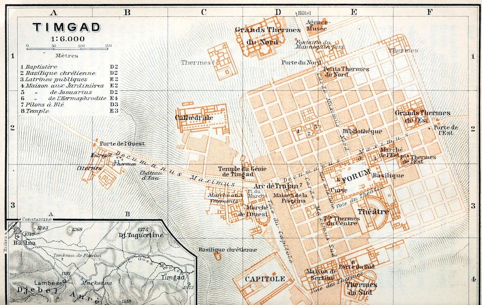
Timgad.—Hotel. Hôtel Meille, 4 min. to the N. of the ruins, opposite the Berber market (Thurs.), with a fine view of the Aurès Mts., R. 3–4, B. 1–1½, déj. 3½, D. 4 fr., plain but well spoken of.
The Ruins may be visited at any time. The chief sights, named in the text in heavy type, may be cursorily seen within 2–3 hrs. For closer study A. Ballu’s Guide Illustré de Timgad (at book-shops 2½, 3½ fr. at the Agence, p. 291, where photographs and picture post-cards also are sold) is valuable. Information as to recent excavations may be obtained from the inspector M. Barry.—Comp, also ‘Carthage, Timgad, Tébessa’, by R. Cagnat (Paris, 1909).
Timgad (3520 ft.), known by the Berber name of Thamugadi in the late-Roman period and one of the most thriving towns in the E. Algerian highlands, dates from 100 A. D., when the legate P. Munatius Gallus, commander of the Third Legion (p. 286), was ordered by Trajan to found the Colonia Marciana Trajana Thamugadi, probably about the same time as Lambæsis, as the key of the Fount Ksantina (p. 296). The town saw its prime in the 290second half of the 2nd and in the 3rd cent., but in the 4th cent., like Bagai (p. 273), it was a centre of the Donatist movement and suffered severely in the wars of the period. After fruitless attempts by the Vandals to revive it, Thamugadi was destroyed by the hostile Berber tribes of the Aurès Mts. in 535. Having been finally abandoned at the close of the Byzantine domination, the ruins of the town, with the exception of Trajan’s Arch, were gradually buried under the deposits of torrents, and for twelve centuries the place was consigned to complete oblivion.
The excavations begun by the French government in 1880, and recently conducted by the architect A. Ballu, have brought to light the most important parts of the town, including the Forum, two Markets, the Capitol, and no less than eleven Thermæ. While the private houses are mostly unpretending and very inferior to those of Pompeii, the public buildings afford most striking evidence of the ancient prosperity of this remote Roman provincial town.
The oldest town, laid out as a square camp (comp. p. 286) of 384 yds. each way, in conformity with its original destination as a frontier-fortress, has four central gates, between which ran the two main streets, the Cardo Maximus and the Decumanus Maximus, intersecting each other at right angles. The ‘Cardo Maximus Nord’ opens into the Decumanus at the Forum, where it stops owing to the unevenness of the soil. Some 90 yds. farther to the W., however, the ‘Cardo Maximus Sud’ leads out of the Decumanus. The rapid increase of the population, especially on the E. and W. sides, on the busy roads to Tebessa (p. 315) and Lambæsis, led as early as the 2nd cent. to the construction or extensive new streets on a less regular plan. By the 5th cent. the population, which had greatly declined, withdrew from the suburbs into the ancient walled precincts, which by this time had been much built over at places.
The main streets are bordered with Doric colonnades and paved with bluish limestone slabs; the smaller streets have sandstone pavement. The waggon-ruts are deep, especially in the Decumanus Maximus, and are slightly farther apart than at Pompeii (4 ft. 3 in. and 4 ft. 1 in.). The excellent drainage-system is now utilized anew, as may be seen from the gutters at the street-corners.
The usual building material was concrete (opus incertum, small stones mixed with mortar), often faced with brick, or stone-framework (the interstices being filled with brick or rubble-work). The private houses usually occupy an Insula, as the square block enclosed by four streets was called. The shops (tabernae) in the main streets were all entered from the street, except when the trader lived in the same house. As a rule the houses, like modern Moorish houses, have their backs turned to the street, looking into an arcaded court (peristyle) in Oriental fashion, instead of opening into a roofed atrium in the ancient Roman style.
We begin our walk at the N. end of the town. On the right, just outside the old town-wall, lie the—
*Grands Thermes du Nord (Pl. D, 1), the largest Roman baths in N. Africa. They form a rectangle of 88½ by 70½ yds., and contain thirty-five different chambers, all symmetrically constructed like others of the later Roman period. Parts of the walls are still 23 ft. in height.
A flight of ten steps on the E. side of the building leads to the Vestibulum, the main entrance to the baths. The adjoining chamber on 291the left opens on to a suite of three spacious halls. The two outer ones were probably the Palaestra for gymnastics and games. In the corner, obliquely opposite the entrance-wall, is a kind of shaft or passage leading to the Apodyterium (undressing and dressing room). The central hall is the largest Frigidarium, containing three basins (piscinae). The chamber on the S. side, between the two smaller basins, served as a passage to the Tepidarium, for hot-air baths and massage. Adjoining the tepidarium on the S. is the largest Caldarium, with three hot-water basins (alvei). Two side-rooms were the Laconica or sweating-baths. Adjacent to them were two smaller Caldaria, to the N. of which, next to the palæstra, were two other Tepidaria. The two rooms at the S.E. and S.W. corners of the baths, each with an ante-room (apodyterium?) and large semicircular niche, are supposed to have been Frigidaria.—As to Heating Apparatus, comp. p. 294.
A little to the left of the main entrance to these Thermæ is the quaint Mannikin Fountain (Pl. D, 1), restored from ancient fragments.
The insignificant building on the E. side of the road is the Agence-Musée (Pl. D, E, 1), containing the offices of the directors of the excavations and a collection of objects found at Timgad. These, however, with the exception of some mosaics, the chief adornment of the African-Roman dwelling, show a provincial and mechanical style of art.
Along the outside walls are ranged the larger sculptures, a great stone vase, fragments of buildings, and Saturn stelæ.
The Entrance Room (I) contains pottery, including numerous lamps.—Room II. Smaller fragments of sculpture, bronze implements, etc.—Rooms III & IV. Desk-cases containing the most valuable finds, notably glass, clay-vases, small implements in bronze and bone. Under the cases are water-pines, etc.—Against the walls are placed mosaics: in R. III, Diana and Actæon, with the name of the artist (Selius), and Neptune in a quadriga; in R. IV, Jupiter and Antiope (inscription, ‘Filadelfis vita’), and Amphitrite on a marine centaur.
We now enter the oldest part of the town by the central Porte du Nord (Pl. D, 1), 13¼ by 5¾ yds., preserved only in its lower parts. Between the pillars of the gateway, once enriched with Corinthian half-columns and pilasters, are the ancient guard-rooms. On the floor are relics of an inscription of 149 A.D., which names Antoninus Pius as the restorer (or finisher) of the gateway.
The first building on the left side of the Cardo Maximus Nord, a street ascending steeply for 185 yds., is that of the Petits Thermes du Nord (Pl. E, 1). On the left, beyond the fourth side-street, is the—
*Library (Pl. E, 2), one of the most curious buildings in the town, resembling the library in the forum of Pompeii, which was once supposed to be a shrine of the Lares. The building is preceded by an open colonnade, with two small chambers on each side. Two side-doors lead into the rectangular book-rooms, while the central door, as in all antique libraries, opens into a kind of sanctuary, with a large central niche flanked by four recesses on each side (for the sacred images), and approached by a basement in three steps, with ornamental columns.
292The Cardo Maximus Nord leads to the main entrance to the Forum (see below) in the Decumanus Maximus, the chief thoroughfare of the town. To the right, at the W. end of the latter, rises Trajan’s Arch (p. 295). We descend to the left. On the left, near the old E. gate of the inner town, are the Grands Thermes de l’Est (Pl. F, 2), whose tepidarium contains remains of mosaic pavement. We turn back here, and in the third S. street off the Decumanus Maximus we come to the Petits Thermes de l’Est (Pl. F, 2), where two of the rooms contain restored marble benches.
Next, on the same side of the Decumanus, comes the *Marché de l’Est or East Macellum (Pl. E, F, 2), the smaller town-market, very curiously planned.
A flight of eight steps ascends to a semicircular vestibule occupying the middle of a platform 30 yds. wide and 2¼ yds. deep, on to the right and on to the left sides of which open six small shops, three of them facing the street and three the courtyard. The latter, really a double court, consists of two segments of a circle with a triangular fountain at their intersection. Adjacent, along the back-wall, right and left, are five stalls with the old stone counters. In the centre of each half-court is an open semicircular colonnade with water-runlets.
Almost immediately to the W. of the market-hall, a later addition, is the Maison aux Jardinières (Pl. 4; E, 2), a private house with a fine garden-court, once adorned with flower-beds. These were enclosed by high segment-shaped stone balustrades.
Near the Fountain at the next street-corner, at the N.E. angle of the Forum, are the Latrinæ (Pl. 3; E, 2), the finest ancient building of the kind, with a washing-basin and excellent cleansing arrangements. The double seats (originally 25) have marble arms adorned with dolphins.
A propylæum, with a vestibule (16 ft. wide) and twelve steps forms the main entrance to the *Forum (Pl. E, 2, 3), the focus of municipal life, to which foot-passengers only were admitted. It was completed in the reign of Trajan, and conforms pretty closely in plan to the rules laid down by Vitruvius. It forms a large rectangle, 110 by 65 yds.; the area or central space, 55 by 47 yds., is enclosed by Corinthian colonnades. The vestibule and area were once adorned by a crowd of equestrian statues of emperors and figures of distinguished governors of Numidia and eminent citizens. The so-called Marsyas, the symbol of civic liberty, marked Thamugadi as one of the most favoured colonies, whose inhabitants enjoyed the full rights of Roman citizenship. Besides the pedestals of thirty-two statues, we note also several representations of figures of a game (comp. p. 318) on the stone slabs of the pavement; among the inscriptions annexed is the light-hearted ‘venari lavari ludere ridere occ (hoc) est vivere’ (to hunt, bathe, play, and laugh is to live).
The chambers on the N. side of the Forum were perhaps Club Rooms. The two-storied Shops on the S. side opened, on the upper floor, into the Theatre Street (p. 293).
293The only building on the E. side of the Forum is the very dilapidated Basilica (Pl. E, 3), once the exchange and court of justice. Unlike most other ancient edifices of the kind, it is a single hall (31 by 16 yds.), with three niches at the N. end and five small chambers on the E. side. The large square niche at the S. end, at the foot of the theatre hill, served as a law-court.
Of the buildings on the W. side of the Forum the two in the middle are the Curia (Pl. E, 3), where the town-council (ordo decurionum) met, a rectangle of 17 by 12 yds., with a colonnade in front and platform behind, and a small Temple (Pl. 8; E, 3), preceded by a speaker’s platform (rostra), 6¾ ft. high. The purpose of the other buildings is unknown.
Near the Fountain at the N.W. angle of the Forum we turn to the S., out of the Decumanus into the Voie de la Curie, and thence to the left into the Voie du Théâtre (38 ft. wide), on the S. side of the Forum.
The Theatre (Pl. E, 3), dating from 167, lies on the W. slope of an isolated hill. It held about 4000 spectators, but little of it is left, as the materials were used in building the Byzantine fortress (p. 296). The semicircular orchestra, with its three tiers for the places of honour (bisellia), allotted to the decuriones and other persons of distinction, is well preserved. The Cavea, or auditorium, 69½ yds. wide, rising on the hill-side, once had twenty-six tiers of seats, but of these the seven lowest only remain. The stage (pulpitum) has been destroyed with the exception of the front-wall, with its niches and steps, and the hyposcenium, consisting of brick pillars (29½ in. high), which supported the floor of the stage. The large colonnaded hall behind the former back-wall of the stage served as a promenade (‘foyer’).
The hill behind the cavea of the theatre, where the remains of a Temple Court have been unearthed, affords a splendid *Survey of the ruins. The view extends to the W. to the distant hills near Batna; to the S.E., beyond the great débris-strewn slopes of the lower hills, rise the Aurès Mts.
From the centre of the theatre colonnade we may walk to the W. to the Petits Thermes du Centre (Pl. E, 3), with admirably preserved heating apparatus in the caldarium and laconicum (p. 291) on the W. side.
On the W. side of these baths runs the Cardo Maximus Sud, the finely paved main street of the S. quarter of the town, leading past the entirely ruined S. Gate (Pl. E, 4) and the house of the Sertii (on the right; p. 294), and ending at a Fountain in the Voie des Thermes.
The *Thermes du Sud (Pl. E, 4), of the 2nd cent., extended in 198 and restored about the end of the 3rd cent., are the finest in the town next to the N. Thermæ.
294A peculiarity of this building consists in the three great Exedræ, semicircular projections on the N.E. and S. sides. The semicircle near the S. entrance contained the Latrinæ, now almost entirely destroyed. The great colonnaded hall near the N. entrance served as a promenade. From the Palæstra, 26 by 10 yds., the largest hall in the baths, bathers could enter the Apodyterium as well as the Frigidarium, flanked by its two piscinæ. The small ante-rooms behind the Frigidarium opened into the heated rooms: on the right the Tepidarium, on the left the large Caldarium with its three hot-water basins, and, straight in front, a smaller Caldarium with two basins. The quadrangular space between the caldaria was the Laconicum.
The cellars on the S. side were partly occupied by the Praefurnium (furnace room). Huge stoves (furnaces) heated the water in cylindrical boilers (testudines, no longer existing) and also the air, both for the Hypocaustum, or hollow floor resting on low brick pillars, and for the hollow tiles (tubuli) or nipple tiles (tegulae mammatae) with which the hollow walls of the hot rooms were lined.
To the S.W. of the thermæ is an Artisan Quarter with a pottery and a bronze-foundry.
We may now visit the Byzantine Fortress (p. 296) or else go direct to the House of the Sertii (Pl. D, E, 4), one of the richest families in the town (comp. p. 295). This building, a great rectangle of 68 by 35½ yds., comprising no fewer than three insulæ or blocks, was built on the site of the ancient town-wall, and extends as far as the Voie du Capitole.
The colonnade in the Cardo Maximus Sud opens on a square Vestibulum. Adjacent, on the right, were a shop of the owner’s, the lodge of the porter (ostiarius), and the stairs ascending to the bath-rooms (balineum). Next to the vestibule came the Peristyle, a colonnaded court in the Doric style, off which opened the owner’s reception-room (tablinum), the dining-room (triclinium), and several bedrooms (cubicula). On the left there was a staircase to the upper story. A second peristyle, with a fountain-basin and a fish-pond (vivarium) was flanked by the offices. The large room at the back was the banqueting-room (oecus). On the W. side of the building were several shops for letting.
On the W. side of the inner town, outside the town-wall, which has here been built over, runs the broad Voie du Capitole, at the upper end of which rises the—
*Capitol (Pl. C, D, 4; comp. p. 288), originally one of the grandest temples in the whole country. A flight of four steps ascends to the propylæum, a portico of twelve columns lately re-erected. The vast temple-court is an irregular quadrangle of about 98 by 68–73 yds.; the peribolos or enclosing wall was restored, according to an inscription, under Valentinian I. in 365. Still later the S. colonnade was converted into a closed corridor with shops. In the middle of the court is the basement of the ancient altar.
A lofty flight of steps, originally 38, broken halfway up by a platform, formed the approach to the temple (58 by 25 yds.). The cella, now destroyed, had three niches, a portico of six columns, and lateral colonnades, while the back-wall was closed. Two of the gigantic columns of the portico, 44 ft. high, have been re-erected, while the huge drums and capitals of others lie around, notably on the S. side of the temple.
295We now walk down the Voie du Capitole to the Marché de l’Ouest (Pl. D, 3), or West Macellum, the largest covered market in the town, probably built by one of the Sertii (p. 294) early in the 3rd century.
The entrance is in the small Place du Marché, on the S. side of the Decumanus Maximus. The entrance colonnade (chalcidicum) leads into the quadrangle, 37 by 27 yds., paved with large slabs of limestone and surrounded by colonnades. In the centre originally stood a square fountain (tholos). At the N. end, near the entrance, were two shops on each side and the stairs to the upper floor. The most curious feature of the building is the raised *Exedra, once roofed, on the S. side of the court, with seven deep recesses, closed, like those of the E. Market (p. 292), by the stone counters of the sellers. Remains of the entablature are exhibited on the outer wall.
The rectangular ‘Marché aux Vêtements’ (Pl. C, D, 3), on the W. side of the Place du Marché, was probably a minor market.
Close by, on the N. side of the Decumanus Maximus, rises the small Temple du Génie de Timgad (Pl. C, D, 3, 4), ‘a miniature capitol’, dedicated in 151 to the genius of the colony. Three flights of steps ascend to the temple-court with relics of the altar. The temple, with its four Corinthian columns in front, is a mere ruin.
We next visit *Trajan’s Arch (Pl. D, 3), the best-known triumphal arch in Algeria, an extremely massive structure, 40 ft. high, much restored in 1900. This was once the W. gate of the inner town (comp. p. 296). Instead of the usual corner-columns of the earlier triumphal arches, it has on each side four projecting Corinthian columns, whose entablature is relieved with rounded pediments in front of the attica. The two middle columns on the E. side terminate in eagles holding thunderbolts in their talons, instead of in volutes as in the usual capital. Of its three passages, which could be closed by means of portcullises, the central one was for vehicles, the two side-arches for foot-passengers. The square niches over the side-gateways, each crowned with an ædicula, were originally adorned with statues.
We now return to the inner part of the town. Between the first and the second S. side-street of the Decumanus Maximus is the Maison de la Piscina (Pl. D, 3), a large dwelling-house occupying two insulæ, so named from the granite basin in the peristyle, adorned with nine little columns of red marble. The œcus, or festal hall, at the S. end, has a tasteful mosaic pavement.
Between the second and third S. side-streets of the Decumanus Maximus lies the open quadrangle of a Granary (horreum), containing numerous grindstones (pilons à blé; Pl. 7, D 3). The house beyond the third side-street contains a Cellar (hypogæum) resting on pillars and lighted by small windows.
The fourth N. side-street of the Decumanus Maximus, in a line with the Voie de la Curie, leads to the ruins of a Monastery of the Byzantine age, containing a balineum or bathroom. The Basilica (Pl. 2, D, 2) is 296a complete ruin. To the N.W. of it is the Baptistery (Pl. 1; D, 2), with relics of the font and its colonnade.
The House of Januarius (Pl. 5; D, E 2), to the N.E. of the church, still has its balineum.
Time permitting, we may visit the ruins outside the town.
From the great N. Thermæ (p. 290) we may walk past the Dépôt des Tapis Indigènes, where the carpets made by the Berbers of the Aurès are sold (adm. free), to other remains of Thermes (Pl. C, 1).
To the S. of this point lies the early-Christian Cathedral (Pl. C, 2), separated by a low hill from the outer Decumanus Maximus. This was a basilica with nave and two aisles, 42 by 18½ yds., with clustered columns and traces of the choirscreen and altar-basement. The sacristies (prothesis and diaconicon), adjoining the raised apse, seem to have been entered from the aisles only.
We next cross the hill and descend to the S.W. to the outer Decumanus Maximus. Here, on the left, quite near the bed of a recently formed torrent, is the Château d’Eau (Pl. B, 3), the remains of an octagonal nymphæum or fountain.
Crossing the bed of the stream, and passing, on the left, the Thermes du Nord-Ouest (Pl. B, 2), we reach the outer Porte de l’Ouest (Pl. B, 2), a single gateway of the age of Marcus Aurelius, well preserved in its lower parts.
From the Nymphæum we ascend on the right bank of the brook towards the Capitol (p. 294), past an early-Christian Chapel (Pl. C, 4), almost destroyed by the stream. Another early-Christian Basilica lies to the S.W. of the Capitol. In the vicinity a large Monastery, including a church and a baptistery containing a font with fine mosaics, has recently been discovered.
Climbing over the hill to the S. of the Capitol, we have another survey of the extensive ruins, and then walk to the S. to the Byzantine fortress, 5 min. beyond the S. Thermæ (p. 293).
The *Byzantine Fortress (beyond Pl. E, 4), erected under Justinian with stones from the theatre, the Capitol, and other Roman buildings for defence against the Aurès Berbers, forms a vast rectangle, 122 by 80 yds., with walls 8 ft. thick, still rising to a height of 23 ft. on the W. side. Four central and four corner towers, and on the S. side a sallying gate, have been preserved.
The so-called Gregory’s Basilica, on a hill 3 min. to the S.W. of the fortress, the latest building in the town, dates only from the time of the governor Gregory (7th cent.; p. 371).
About 2 hrs. to the S.W. of Timgad lie the ruins of the ancient Berber town of Ichoukkàn, on a lofty plateau inaccessible on three sides, above the rock-gateway of Foum Ksantina (‘Constantine-Gate’), so called from the resemblance of its situation to that of Constantine. Near it are extensive burial-grounds with thousands of graves.
297
46. Constantine.
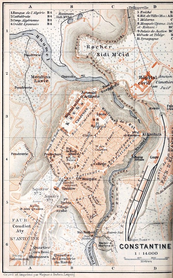
The Station (Pl. D, 4; Rail. Restaurant) for Algiers (R. 43), Biskra (R. 44), Philippeville (R. 47), Bona (R. 48), and Souk-Ahras (Tebessa, Tunis; RR. 49–51) is in the Faubourg d’el-Kantara, on the right bank of the Rhumel, 15–18 min. from the hotels.
Hotels (comp. p. 174). Grand-Hôtel (Pl. a; B, 4, 5), Rue Nationale 2, corner of Place de Nemours, with good restaurant, R. 3½–5, B. 1–1½, déj. 3½, D 4–5, pens. 10–12½ fr., omn. 1 fr.; Hôt. St. Georges & d’Orient (Pl. b; B, 4), Rue Caraman 9, R. 3, pens. 10, omn. ¾ fr., good cuisine; Hôt. de Paris & Royal (Pl. c; B, 4), Rue Nationale and Place de Nemours, R. 4, B. 1½, D. 4, pens. 9–11, omn. 1½ fr.—Hôt. Terminus, near the station, for a short stay, R. 3, déj. or D. 3 fr., plain but quite good; Hôt. Rouvière (Pl. e; B, 4), unpretending but well spoken of.
Cafés. Café Germain, Place de Nemours; Café Glacier, Place du Palais 8; Café Honorat, in the Hôt. de Paris, Place de Nemours (music in the evening).—Restaurants (beer). Taverne Gambrinus, Rue Caraman 6; Brasserie de l’Etoile, Place de Nemours.
Post & Telegraph Office (Pl. 10; B, 5), Place de Nemours.
Cabs (stand, Place de Nemours), first ½ hr. 1¼ (after 10 p.m. 1½) fr.; for 1 hr. 2½, each addit. ½ hr. 1 fr.; half-day (6 hrs.) 10, whole day (12 hrs.) 20 fr.—Omnibus from the Place de Nemours to the Station 10, trunk 25 c.; also to the Faubourg St. Jean.
Baths. Bains Lyonnais, Rue Damrémont; Bains Rémès, in the ravine of the Rhumel (p. 302).
Booksellers. Braham, Rue du Palais 4; Roubille, Rue Damrémont 37.—Newspaper. Dépêche de Constantine.
Theatre. Théâtre Municipal (Pl. B, 5; Nov.–Feb. only), Place de Nemours.
One Day. Forenoon, Place de Nemours and Squares, Museum, Palais de Hadj Ahmed, Jewish Quarter, *Quartier Perrégaux (pp. 299–301). Afternoon, *Gorges du Rhumel (p. 301). Guide quite unnecessary.
Constantine (1752–2113 ft.; pop. 55,000, incl. 28,300 Mohammedans and 8300 Jews), Arabic Ksantina or Blad el-Hawa (‘cité aérienne’, ‘town of air’), the capital of the province of that name and the seat of a bishop and of a medersa (Mohammedan college), is the third-largest town in Algeria. The old town, typically Berber in its difficulty of access, lies on a chalky limestone plateau, descending to the S.E. and N.E. almost perpendicularly to the Ravine of the Rhumel, and to the N.W. to the bed of a brook, while on the S.W. it is connected by a narrow saddle with the spurs of the long Jebel Chettaba (4313 ft.). The town has three suburbs, the small Faubourg d’el-Kantara near the station, and the faubourgs St. Jean and St. Antoine on the margin of the Coudiat-Aty (Pl. A, 5, 6), a hill recently almost levelled to form a building-site.
Constantine is the centre of the Algerian grain-trade and has an important wool-exchange. Several manufactures too are very active (tanning, shoemaking, saddlery, and weaving). The chief centres of trade and manufacture are still the native quarters, resembling the Kasba of Algiers, the picturesque charm of which has so far been marred by the construction of but few new streets. The gay costumes of the Mohammedans and the mediæval attire of the Jewesses are specially interesting.
298Constantine has but a poor climate. Spring is the best season for visiting it. In winter the cold (p. 170) is very severe and the winds are often bitter, while in summer and autumn the hot sirocco is more prevalent than anywhere on the coast. The low ground flanking the Rhumel is malarious from June to October.
Constantine, originally the Phœnician Kartha (‘town’), afterwards called Cirta by the Romans, was the greatest inland centre of culture in the territory of the Numidian kings, and under Syphax became their residence. The first recorded conquest of the town was by Jugurtha (p. 321), in B.C. 112, who wrested it from his cousin Adherbal. Under the Roman empire Cirta, the chief of the four allied Coloniæ Cirtenses (Constantine, Milo, Philippeville, and Collo), belonged to the Diocesis Numidia, the domain of the legate of the Third Legion (p. 286). Having been destroyed by the troops of Emp. Maxentius in 311, the town sprang up anew from its ruins the following year; it then superseded Lambæsis as the capital of Numidia, and was named Constantina, in honour of its patron Constantine the Great. In 435 it was the only town in Barbary that repelled the attacks of the Vandal Genseric (p. 322), but it remained politically unimportant till the Moorish period, when it was occupied by the Hammadites (p. 263), and afterwards belonged in turn to the Almohades (p. 95), the Merinides (p. 95), and the Hafsides (p. 323). In the middle ages it rivalled Bougie as a seat of learning.
In the Turkish period Constantine was the capital of the E. Algerian beylic, and for centuries groaned under the despotism of the beys. In French military annals it was noted for its heroic defence by Ahmed Bey, who after the fall of Algiers had become the independent ruler of E. Algeria. In 1836 the first French attack upon the El-Kantara gate from the hill of Mansoura proved a disastrous failure, over five hundred of the besiegers being hurled into the ravine of the Rhumel. The capture of the town in 1837, effected from the Coudiat-Aty, was purchased with the death of generals Damrémont and Perrégaux.
During the first decades of the French domination all the Roman buildings were destroyed except the aqueduct (p. 302), the Rhumel bridge (p. 301), and the cisterns (p. 300). The buildings of the Turkish period afford an instructive example of the sad decline of late-Moorish art.
The railway-station (Pl. D, 4) is at present connected with the old town by the iron bridge of *El-Kántara (Pl. D, 3; 1863), of one arch, 139 yds. long and 407 ft. above the Rhumel. Far below we see the Roman bridge (p. 301), and upstream we have a fine view of the S. part of the gorge. Much higher up is the New Bridge (comp. Pl. C, 6), a marvellous feat of engineering. It spans the Rhumel ravine, at a height of 330 ft. above the river, with a single arch of masonry, 230 ft. in width.
From the former Porte d’el-Kantara runs the new Rue Nationale (Pl. C, B, 4), the chief thoroughfare of Constantine, leading through the whole town to (½ M.) the Place de Nemours. Halfway, where the street bends and is crossed by the Rue Perrégaux (p. 301), rises the new Medersa (Pl. 7, C 4; see p. 297) in the Turkish-Moorish style; from its staircase we enjoy an even finer view of the Rhumel ravine than from the crossroads.
Halfway along the upper part of the street, on the left, rises the Grande Mosquée (Pl. B, 4, 5; Arabic Jâma el-Kebîr), which received a new façade and minaret when the street was made. The 299very dissimilar columns which support the timber ceiling in the interior are partly from ancient buildings. Two antique Doric capitals recall the columns of the mausoleum of Le Khroub (p. 273).
The noisy and dusty Place de Nemours or Place de la Brèche (Pl. B, 4, 5; 2054 ft. above sea-level), on the site of the Bâb el-Djadia or Porte de la Brèche, is the chief scene of the town’s traffic. A few paces to the S.W., between the old town and the Coudiat-Aty (p. 297), are two public gardens. On the left, next the street leading to the new bridge, is the pretty Square No. 1 (Pl. A, B, 5), with a bronze statue of Valée; and on the right Square No. 2 (Pl. A, 5), with numerous Roman antiquities. The latter affords a splendid view of Jebel Chettaba (p. 297), of the lower valley of the Rhumel visible a long way down, and of the distant heights of El-Kantour (p. 303). The road between the two squares proceeds to the S.W. to the Monument of Gen. Lamoricière (Pl. A, 5) by Belloc (1909), in front of the Halle aux Grains.—From the latter the new Viaduct (comp. Pl. A-C, 5, 6; 490 yds.), now under construction, will eventually lead to the New Bridge (p. 298).
Beneath the Hôtel de Paris et Royal (p. 297), at the E. corner of the Place de Nemours, a flight of 90 steps descends to some interesting Grottoes (adm. 1 fr.), whose sparkling, rose-shaped crystals of gypsum produce a very unique effect.—From the N. angle of the square the Boul. de l’Ouest leads along the town-wall to the Hôtel de Ville (Pl. 6; A, B, 4), of 1903, whose staircase and vestibule are enriched with onyx and six kinds of marble from Aïn-Smara (p. 272). The first floor contains the Town Library and behind it the—
Musée de Constantine, comprising antiquities and natural history collections. Adm. (except Sun. and Tues.) 9–11 and 3–5, 50 c. Conservator, M. Ulysse Hinglais. Catalogue (1905) 1 or 5 fr.
On the Staircase are Roman mosaics.
Room I. In the central cases are prehistoric finds from the Tell Atlas and the Oued Rhir (p. 285); Byzantine and early-Moorish antiquities from Morsott (p. 314) and Kalâa des Beni-Hammad (p. 270); natural history specimens (incl. vegetable fibres utilized industrially). The wall-presses contain fossils from the hill of Mansoura (p. 302) and Jebel Sidi M’Cid; Phœnician and Roman antiquities from the necropolises of the Coudiat-Aty, of Collo, Bulla Regia, etc. (clay vases, fine Roman bronzes, a glass cinerary urn, trinkets, cut gems). By the wall of exit are Spanish-Moorish, Italian, and Kabylian ceramics, Moorish fayence from Tlemcen, Nabeul (p. 365), etc.; a late-Moorish door; a Turkish executioner’s sword from Khenchela. Here too are a map of the artesian wells in the province of Constantine and a model of a boring apparatus.
Room II. The show-cases contain coins and medals. In the wall-presses, natural history specimens; marble and onyx from Aïn-Smara. On the walls, a small collection of pictures.
Gallery (on the left of R. I). Large Roman clay vessels, neo-Punic and Roman stelæ, Roman sculptures, Moorish fragments, casts.
From the Boul. de l’Ouest the Boul. du Nord (Pl. A, B, 4, 3; fine views) and (to the right) the Rue du Rocher lead to the Kasba (p. 300).
300The busiest streets of the European quarter, where many of the inhabitants are Italians and Maltese, are the Rue Caraman (Pl. B, 4) with the Rue Chevalier, the Rue d’Aumale, and the Rue Damrémont (Pl. B, 4, 3), all to the N. of the Place de Nemours. Between these lines of streets lies the spacious Place du Palais (Pl. B, 4).
The Palais de Hadj Ahmed (Pl. B, 4; now military headquarters), on the N.E. side of the square, built by Ahmed Bey in 1828–35, contains four picturesque courts, adorned with tiles. The front court is decorated with clumsy frescoes depicting chief towns of the Orient. The interior is not shown. Concierge ½ fr.
The Cathedral (Pl. 2, B 4; Notre-Dame des Sept-Douleurs), on the E. side of the Place du Palais, was once the Market Mosque (Jâma Sûk er-Rezel), with its nave and double aisles, built in 1707. The women’s galleries next the entrance-wall now contain the organ. The choir is a modern addition. In the outer right aisle, in the middle of the E. wall, with its well-preserved tile and stucco decoration, is the old mihrâb (p. 180), now a chapel. The mimbar in the inner left aisle is now the pulpit; behind it is a copy of the inscription on the Rocher des Martyrs (p. 301).
The Rue Caraman, continued by the Rue Chevalier, and the Rue de France (Pl. B, C, 4, 3) both lead to the N.E. to the Place Négrier (Pl. C, 3), in which rises the Mosque of Sidi el-Kettani (Pl. 8; B, C, 3), built by Sala-Bey. The first floor of the building contains a marble mimbar executed by Italian sculptors. On the N. side of the square is a new Synagogue (Pl. 11; C, 3).
At the N. end of the town, partly on the site of the Roman capitol, is the old Kasba (Pl. B, 3; 2116 ft.; 666 ft. above the Rhumel), now a group of new buildings, including barracks and the military hospital. Of the Roman Cisterns, originally a quadrangle of 164 by 39 yds., about one-third has been preserved and is now again in use. The view from the garden of the Artillery Arsenal (Pl. B, C, 2, 3), at the N. end of the Kasba, immediately above the ravine of the Rhumel, is justly extolled. Adm. by leave of the military authorities (Palais de Hadj Ahmed; see above). Entrance in the Rue Damrémont (p. 299). From the Kasba the new Suspension Bridge (‘Pont Suspendu’; Pl. C, D, 2, 3) crosses the Rhumel at a height of 590 ft. to the Hôpital Civil (Pl. D, 2).
The *Native Quarters, intersected by the upper Rue Nationale, with their lively, picturesque, crooked streets, lie in the lower part of the town, between the Place de Nemours, Rue Caraman, Rue de France, and the Rhumel ravine (p. 301). The most interesting streets are those inhabited by Mohammedan artisans, largely Mozabites (p. 216), between the Rue Combes (Pl. B, 4) and the Rue Vieux (Pl. B, C, 4, 3), both of which lead to the N.E. to the Place Rahbet es Souf (‘wool-market’) or Place des Galettes (Pl. C, 4), with its Market Hall. Between this square and the Boul. de l’Est 301(Pl. C, 3), a fine point of view, lies the Jewish Quarter, which is worth seeing, especially on Saturdays.
Still more picturesque than these quarters is the purely Mohammedan *Quartier Perrégaux, which descends the triangular S. part of the rocky plateau, often in steep steps, from the Rue Nationale to the Rhumel Ravine. Through this quarter runs the Rue Perrégaux (Pl. C, B, 4, 5), the chief thoroughfare between the Rue Nationale and the old Turkish Porte Djebia (Pl. B, 5). Near this gate, at the corner of the Rue Perrégaux and Rue des Tanneurs, is a Mosque Portal with charming tile-decoration.
From the Rue Perrégaux we may descend by the Rue de l’Arc and (to the right) the Rue de l’Alma, or direct by the Rue Morland, under the new bridge, to the small kubba of Sidi-Rached (Pl. B, C, 6; 1752 ft.). From the adjacent rocky height we have a grand view of the upper Rhumel ravine. Opposite, near the old Pont du Diable (Pl. B, C, 6), is the Rocher des Martyrs, bearing an old inscription in memory of the Christian martyrs of 259.
The **Gorges du Rhumel, the grandest ravines in the Tell Atlas, present a most impressive scene, especially during the melting of the snow or after heavy rain, but in summer much of their charm is lost owing to the lowness of the stream and the stench of the tanneries. The gorge was first made accessible in 1895 by the Chemin des Touristes, a path 1¾ M. in length, constructed by the engineer Fr. Rémès. From the S. entrance (Pl. C, 6; 1811 ft.), near the new bridge, it descends parallel with the Chemin du Rhumel (10 min. above the station), close past the main entrance (see below) and under the El-Kantara bridge and the new Suspension Bridge to the lower end of the ravine (1512 ft). It is to be connected with the new N. entrance (Pl. B, 2), on the Corniche road (p. 302), by a side-branch. Tourists pressed for time may go direct from the station to the S. entrance, walk down the gorge as far as the grottoes, turn back there, and then leave by the main entrance. A ticket for the day (2 fr., or for repeated visits ½ fr. each time) admits also to a bath in the Bains Rémès.
The main-entrance, near the so-called Porte Vitruve (1730 ft.), is reached from the Boul. de l’Est, 45 yds. to the N. of the old El-Kantara gate (p. 298), by an uncomfortable path descending in steps; another descends from the Corniche road on the opposite side (‘Entrée’; Pl. D, 3), 3 min. below the bridge.
Before entering the gorge we may glance at the remains of the Roman Bridge, which crosses the river at the narrowest part, 66 yds. across. The sculptures, two elephants and a weather-worn relief of Africa, belonged perhaps to a still older bridge.
From the ticket-office we first walk upstream, on the right bank, 302by the Upper Path, often up and down steps. The rocky sides of the gorge are enlivened by numerous storks, pigeons, and hawks; far below us the river dashes down its stony bed. High above peep the picturesque houses of the native quarter. On the left bank are the Bains Rémès, with a hot spring (90° Fahr.), and remains of a Roman Aqueduct. They are reached by a side-path to the right, ca. 220 yds. beyond the ticket-office. The baths, or Piscinae, originally Roman, have been entirely renewed.
Farther up (¼ hr.), a path in steps ascends to the left, under the new bridge, not far from the Pont du Diable and the Pointe de Sidi-Rached (comp. p. 301), to the S. entrance.
We now return to the chief entrance, and near the office descend to the left, by a path with steps and iron stairs, to the *Grottoes, 230 ft. high at places, through which the river flows, mostly underground, for a distance of 330 yds.; the huge dome of rock is specially impressive when viewed from the middle of the iron footbridge. A winding staircase next descends to the Lower Path, with its wire-fence and benches. Passing below the new Suspension Bridge (p. 300) we reach the last arch of rock (retrospect of the grottoes) and in a few minutes the lower (N.W.) end of the gorge, above the Cascades (Pl. B, 2).
Those who do not care to return to the El-Kantara bridge may ascend direct from the last archway to the Corniche road.
The Rhumel Fall, dashing over rock-terraces to a depth of 212 ft., the precipice below the Kasba, and the Rocher Sidi M’Cid (see below) are all admirably viewed from the Moulins Lavie (Pl. A, 2), on the left bank, 10 min. from Square No. 2 (p. 299).
The traveller should not omit to take a short walk on the superb *Route de la Corniche (Pl. D-B, 3–1), starting from the El-Kantara bridge. Below the Hôpital Civil (p. 300) two short tunnels carry the road through the Rocher Sidi M’Cid, an offshoot of Jebel Sidi M’Cid (2575 ft). The finest point is (¼ hr.) a small projecting platform at a bend in the road, whence we look down on the Rhumel Fall and the baths of Sidi M’Cid.
In a dale at the N. base of the Rocher Sidi M’Cid lies the pleasant Hammam Sidi M’Cid (Pl. B, 1), with saline springs and two large swimming-baths.
The ‘Grand Tour’ (1–1¼ hr.; carr. 3–4 fr.; bargain advisable) is a favourite drive by the Route de Sétif (Pl. A, 5, 6; affording a fine retrospect of the Quartier Perrégaux), and across the uppermost Rhumel bridge, to the Roman Aqueduct (p. 274); thence from the Route de Batna to the right to the Pépinière, in a dale full of fruit-trees, and charming in spring; lastly over the pine-clad Mansoura Hill, crowned with a fort, and back by the Chemin de Mansoura (Pl. D, 5) to the bridge of El-Kantara.
From Constantine to Algiers, see R. 43; to Bona, see R. 48; to Biskra, see R. 44; to Philippeville, see R. 47; to Djidjelli (Bougie), see R. 42; to Souk-Ahras, see R. 49; to Tunis, see RR. 49, 51.
303
47. From Constantine to Philippeville.
54 M. Railway in 3–4¾ hrs. (9 fr. 75, 7 fr. 30, 5 fr. 35 c.). Railway Restaurant at Col-des-Oliviers.
Constantine, see p. 297. Running to the N., the line pierces the Rocher Sidi M’Cid (p. 302) by tunnels, proceeds high above Hammam Sidi M’Cid (p. 302) and the Rhumel, with a splendid retrospect of Constantine, and then curves round to (4½ M.) Le Hamma (1614 ft.), station for the Oasis du Hamma, a luxuriantly fertile dale with countless fruit-trees, watered by the Hamma and several springs.
8 M. Bizot (1805 ft.). It then descends to the Oued Smendou, a tributary of the Rhumel, and ascends its right bank to (17 M.) Condé-Smendou (1838 ft.).
We cross several feeders of the Oued Safsaf (see below) and pass through the Hills of El-Kantour in several tunnels, below the pass of that name, now called also Col-des-Oliviers.
25½ M. Col-des-Oliviers (1365 ft.; Rail. Restaurant), station for a group of small villages inhabited by immigrant farmers. Thence a steep, winding descent, in a hill-region denuded of its forest, to (31 M.) Bougrina, like Robertville, a station for the large village of El-Arrouch.
35½ M. Robertville (348 ft.; several inns), a village on the Oued Ahmar, is the starting-point of the fine hill-roads through the Massif de Philippeville viâ (23 M.) Bordj Tamalous to (40 M.) Collo (p. 131; diligence twice daily in 8 hrs.), and to Djidjelli (p. 267; motor-omnibus, see p. 267).
The train now descends into the valley of the Oued Safsaf, where wild olives, poplars, and cork-trees abound.
42½ M. St. Charles (138 ft.; Hôt. du Lion d’Or), the oldest farming settlement in the district, founded by Germans and Belgians in 1840, was at first defended by four small forts.
From St. Charles to Bona, 61½ M., railway in 4–5 hrs. (7 fr. 50, 5 fr. 5, 4 fr. 5 c.). 9 M. Râs el-Ma, with a quicksilver-mine; 15½ M. Jemmapes (312 ft.; Hôt. d’Orient; pop. 2800), on the Oued Fendek, a little town founded in 1848, the chief place on the roads from Philippeville to Bona and to Guelma (p. 308); 19½ M. Oued-Hammimine, a small bath-hotel (pens. with bath 6 fr.), with three hot sulphur-springs (95–115° Fahr.; season Sept.–Nov. only); 41 M. Aïn-Mokra (85 ft.), on a slope near the malarious flats of Lac Fetzara, a swamp of about 35,000 acres, and the now abandoned iron-mines of the Comp. du Mokta el-Hadid; 45½ M. Aïn-Daliah, for the new mine of Marouania belonging to the same company. 61½ M. Bona, see p. 309.
We descend the narrow Safsaf valley to (47½ M.) Safsaf. 50½ M. Damrémont (33 ft.) is the station also for Valée (122 ft.), a village on the vine-clad right bank, on the Bona and Guelma road (see above).—The train leaves the Safsaf, crosses its tributary Oued Zeramna (p. 305), and passes through a tunnel under the W. slope of Mont Skikda (p. 304).
30454 M. Philippeville.—The Station (Pl. C, 2; no buffet) is not far from the quay, a few paces from Place de Marqué.
Arrival by Sea (comp. RR. 20, 22). The steamers of the Gén. Transatlantique (agent, Fauré, Place de Marqué) moor at the quay; those of the Transports Maritimes (agent, Caffa) and of the Navigation Mixte (agents, Daprela & Campiglia, Place du Commerce) anchor in the Grande Darse (Pl. C, D, 1). Cab-fares, see below. Portefaix (porter) for articles under 20 kilos (44 lbs.) to the station 25, to the town 40 c.; trunk 50 or 75 c.
Hotels (comp. p. 174). Grand-Hôtel (Pl. a; C, 2), Place de Marqué, with fine views, R. 3–5, déj. 2½, D. 3, pens. 8½ fr., good; Hôt. Foy, same square (Pl. B, 2), new, R. 3–6 fr., B. 60 c., déj. or D. 2½, pens. from 8 fr.; Hôt. de France & de la Marine (Pl. b; B, 2), same square, No. 3, R. 2–3, B. ¾, déj. 2½, D. 3 fr.; Hôt. Léger, Rue Nationale, R. 2–5, B. ¾, déj. 2½, D. 3, pens. 6–7 fr., plain but good; Nouvelle Poste (Pl. d; B, 2), Place du Commerce, Cinq Nations (Pl. e; C, 3), Rue de Constantine, corner of Rue Gambetta, both plain.
Cafés-Restaurants. Café de Foy, at the hotel (see above); Boutin, Plage du Château-Vert (in summer).
Post & Telegraph Office (Pl. 5; B, 2), Place du Commerce.
Banks. Banque de l’Algérie, Avenue du Troisième-Zouaves; Comp. Algérienne and Crédit Lyonnais, Rue Nationale 30 and 51.
Baths in the Grand-Hôtel; also Tenienski, Rue Buffon.—Sea Baths. Bassin du Château-Vert (see below); at Stora (p. 306), etc.
Theatre. Théâtre Municipal (Pl. 7; B, C, 3), Place Corneille (sometimes Italian pieces).—Band on Sun. in the Place de Marqué.
Cabs (stand, Place Corneille). Drive 1 fr.; first hr. 2½, each addit. hr. 2 fr.; half-day 10, whole day 18 fr.—Diligence to Stora (50 c.), St. Antoine (25 c.), etc.
British Vice-Consul, W. H. Miller, Rue Téophile Réguis.
Philippeville (Arabic Skikda; pop. 26,000, incl. 16,000 Europeans, mostly Italians and Maltese, and 4800 Mohammedans), the youngest Algerian seaport, was founded by Marshal Valeé in 1838 as a harbour for Constantine. It lies on the fine Gulf of Stora (p. 128), about 1 M. to the W. of the mouth of the Safsaf (p. 303), in a ravine between Mont Skikda (548 ft.) to the E. and Jebel Bou Yala to the S.W. Its site is that of the ancient Rusicade, once a Phœnician town, but founded anew by the Romans in 45 B.C. Under the empire, as the Colonia Veneria Rusicade, it belonged to the league of Cirta (p. 298), but, according to local tradition, it had ceased to exist by 484. The chief harbour in the gulf, being well sheltered, was formerly the neighbouring Asthoret, now Stora (p. 306), but it has been superseded by that of Philippeville, constructed in 1860–80 at a cost of some 20 million francs.
The Harbour, after Bona (p. 309) the chief outlet for the produce of the province of Constantine, consists of an excellent inner basin of 50 acres (Grande Darse; Pl. C, D, 1) and an Avant-Port (Pl. A, B, 1) of 75 acres. The Grande Jetée du Nord (Pl. D, 1), running out from Cape Skikda, is 1 M., the Jetée du Château-Vert (Pl. A, 1), on the W. side, ¼ M. in length.
The best points for viewing the harbour and bay are the Place de Marqué (Pl. B, C, 2; popularly Pl. de la Marine), the pretty Petit Bois or Jardin de l’Hôpital (Pl. C, 2), adjacent on the E., and the lofty Place des Zouaves (Pl. D, 2, 3; drilling-ground).
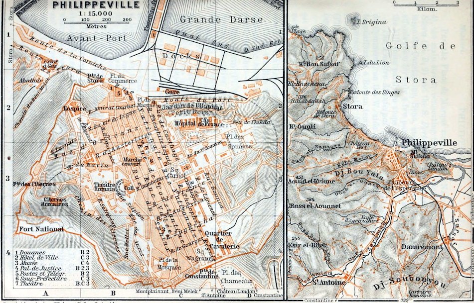
305Past the Place de Marqué runs the Rue Nationale (Pl. B, C, 2–4), the main street, connecting the chief gates, the N.W. Porte de Stora (Pl. B, 2) and the S. Porte de Constantine (Pl. C, 4), whence issue the Constantine, Bona, and Guelma roads. The narrow gorge affords room for only a few parallel streets. The side-streets ascend the hill-sides partly in steps.
The Théâtre Municipal (Pl. 7; B, C, 3), in the narrow Place du Commerce, on the W. side of the Rue Nationale, stands on the foundations of a Roman temple. A little farther, on the E. side of the street, is the pretty Square Carnot (Pl. C, 3).—To the W. from this square the Rue Gambetta leads to the Collège Communal (Pl. B, 3). On the N.E. slope of Jebel Bou Yala, behind the school (apply to the concierge here, 30–50 c.) lies the—
Roman Theatre, the largest in Algeria, erected at the earliest under Hadrian; but as it was used as a quarry for building the modern town, little of it is now left. Of the cavea, 90 yds. wide, which held 5–6000 spectators, only a few steps, two passages, and relics of vaulting remain. The stage is below the school-building.
From the Rue Gambetta the Rue Valée (Pl. B, C, 3, 4) leads through the heart of the Mohammedan quarter to the Rue St. Augustin and the—
Museum (Pl. 3; C, 4). The collections include some valuable Roman antiquities. Adm. daily, 8–6; Sun. and Thurs. free; on other days 1 fr.; catalogue (1901) 1 fr. 10 c.; curator, M. L. Bertrand.
The Garden contains numerous Roman columns, statues, etc.
The Pavillon Central has archæological collections on the groundfloor. In the centre, 173. Roman milestone, from Hadrian’s road from Rusicade to Cirta (p. 298); 151. Antoninus Pius, in marble. In the first wall-press are objects from Roman tombs, mostly from Rusicade; 687. Genius, a statuette in marble. Detached, 749. Punic tomb-stela. In the second wall-press, Roman vases and lamps; also, *805. Bust of a youth, after an Attic work of the age of Praxiteles; 806. Bust of Agrippina the Elder; 778. Punic stela of the goddess Tanit, from Carthage; 779. Mithras stone; 783. Boy’s head; 904. Clay statuette of a woman bathing; 968. Bust of Hadrian. By the following end-wall, Roman inscriptions and altars. At the other end, one early-Christian (293) and two late-Roman sarcophagi (224, 331), Roman inscriptions, etc.—The 1st Floor contains ethnographical and natural history collections and pictures.
The Pavillon Nord contains coins and medals, the Pavillon Sud a small collection of weapons and flags.
Excursions. Bearing a little to the left from the Porte de Constantine (see above), we cross the large Place des Chameaux (Pl. D, 4), where an interesting Cattle Market is held on Thursday mornings, and then follow the S. slope of Mont Skikda (p. 304), past the Cemetery, to (½ hr.) the Château Landon or Domaine des Lions, which has a beautiful garden. (Visitors require the permission of M. Gallard, the superintendent, Rue Galbois.)
The St. Charles (and Constantine) road leads through the Faubourg de l’Espérance in the fertile dale of the Oued Zeramna, 306past the (2½ M.) Ecole Pratique d’Agriculture, to the prettily situated village of (3¾ M.) St. Antoine (33 ft.; diligence 25 c.).
From St. Antoine we may visit, viâ the Route de Praxbourg, the Oued Amida, or upper valley of the Zeramna, a hill-region where cork-tree plantations abound, and a favourite resort of wild-boar and jackal hunters. Or we may follow the Chemin de la Carrière Romaine across the Col Chambœuf, on Jebel Soubouyou (1050 ft.), to Damrémont (p. 303).
To the W. of the Porte de Constantine a picturesque road leads viâ Montplaisant to the dale of Beni Melek, famed for its wine. We may return thence viâ the Porte des Citernes (Pl. A, 3) and Rue d’Orléans, or descend the Chemin du Beni-Melek to the Route de Stora.
For a visit to Stora we may take the *Route de la Corniche, the beautiful new shore-road which starts from the Place de Marqué (Pl. B, C, 2) and at places is tunnelled through the living rock (ca. 2 M.; diligence). Or we may follow the picturesque Route de Stora (2½ M.), the old upper road, beginning at the Stora Gate (p. 305). Stora, a fishing-village with sea-baths, is now inhabited chiefly by Italians. The fine view hence extends to Jebel Filfila and the Cap de Fer (p. 131). On the steep shore are fragments of an Aqueduct, partly underground, and several Cisterns (restored), relics of the Roman Asthoret (p. 304). A vault now used as a laundry probably belonged to a Nymphaeum or fountain.
48. From Constantine to Bona viâ Duvivier.
135½ M. Railway, in 7–8¾ hrs. (24 fr. 65, 17 fr. 60, 13 fr. 20 c.). The morning train has a dining-car between Le Khroub and Duvivier. Buffets at Le Khroub and Duvivier. The only intermediate station of interest is Hammam-Meskoutine.
From Constantine to (10 M.) Le Khroub, see pp. 274, 273.
Our line diverges to the E. from those to Algiers and Biskra (RR. 43, 44) and ascends between low hills in the bleak valley of the Oued Berda, a tributary of the Oued Bou Merzoug (p. 272).
18 M. Bou-Nouara (2330 ft.) has an ancient Berber Necropolis, whose dolmens and rock-tombs, 1¼ M. to the N. of the railway, extend along the spurs of Jebel Mazela (3412 ft.).
25½ M. Aïn-Abid (2822 ft.), the highest point on the line, lies on the watershed between the Oued Berda and the Oued Zenati, one of the feeders of the Seybouse (p. 308). 35 M. Aïn-Regada (2487 ft.), also in a dreary steppe.
42 M. Oued-Zenati (2268 ft.; Hôt. de France), pleasantly situated on a partially wooded hill-side, the only large village before Guelma, has a busy market (Sun., Mon., Thurs.).
The Road to Guelma (28 M.; diligence in 4¼ hrs.) leads to the N.E. through a pretty hill-country direct to Medjez-Amar (p. 308), just before (14¼ M.) Aïn-Amara, and below Thibilis (p. 307).
307Road and railway make a long bend to the W. round the hill-region of Bou Hamdan. Beyond (52 M.) Bordj Sabath (1759 ft.), where, below the influx of the Oued Sabath, the Zenati is called Oued Bou Hamdan, the scenery changes. The valley, whose slopes are richly overgrown with olive-trees and underwood, contracts. In the stony river-bed grow many wild oleanders.
59 M. Taya (1312 ft.), a pleasant oasis with fruit-trees and eucalypti, lies near the stalactite grottoes, not easy of access, in the limestone hill of Jebel Taya (3963 ft.). The valley again contracts in the two Gorges de Taya.
68 M. Hammam-Meskoutine (1312 ft.; *Hôtel des Bains; R. 5–6, B. 1½, déj. 3½, D. 4, pens. 14, motor-omn. 1¼–1½ fr., open 15th Nov. to June), the Roman Aquae Thibilitanae, is now one of the most noted baths in Algeria. The ‘indifferent’ springs are strongly impregnated with chloride of sodium and sulphate of lime; one, containing iron, has a temperature of 187° Fahr., the others 226°. The latter form the *Grande Cascade, 5 min. from the station, on the way to the hotel, falling over a terrace of calc-sinter 42 ft. high, a miniature edition of the terraces of Yellowstone Park, or of Hierapolis (in Asia Minor). Below the terrace rise date-palms and splendid olive-trees, while the bed of the Oued Chedakra with its profusion of oleanders further enhances the peculiar charm of the scene. The curious limestone cones, a few paces to the E., relics of old eruptions, have given rise to the Arabian legend of the petrified wedding party, from which the place derives its name (‘Baths of the Petrified’). Smaller springs rise beyond these cones and also 3 min. to the E., near the railway.
Enclosed by the houses of the bath-hotel is a charming Garden Court, with orange and lemon trees. Most curious among the numerous Roman antiquities (stelæ, funerary inscriptions, etc.) placed here is the house-altar of the Antistii, from Thibilis (see below), on the S. terrace, shaded by a venerable terebinth. The ruined Piscinae are the only relics of Roman buildings.
Excursions. To the S.W. lies the (¾ hr.) Lac Souterrain, a pond 88 ft. deep, in a cavern formed in 1878 by a landslip. In sunshine (best 2–4 p.m.) the water assumes a beautiful blue colour.—To the S., a little aside from the lake just mentioned, we may ride on mule-back, or walk, viâ Aïn-St. Charles and Aïn-Amara (see above) to (2 hrs.) Announa, the Roman Thibilis, lying on a narrow hill (ca. 2300 ft.), high above the Announa Valley, where excavations have been made since 1905. We note specially the East Gate, the Entrance Arch of the forum, vestiges of the Market Basilica, the house of Magister Pagus, and the sadly ruined South Gate, the only two-arched Roman gateway in Algeria. Outside the late-Byzantine town-walls, on the S.W. side of the little town, is the Byzantine Basilica built of fragments of Roman buildings; in the semicircular choir-recess are five rows of seats for the clergy, with the bishop’s place in the centre.—A new road (carr. 12 fr.) leads to the N.W. to (9½ M.) the ancient Berber Necropolis of Roknia, on the W. slope of Jebel Debar (3442 ft.), with many dolmens (p. 324) and rock-tombs, sadly damaged of late.
308The train next makes a wide bend to the S., round the wooded hills of the Beni Addi, past the influx of the Oued Cherf into the Bou Hamdan, which now takes the name of Seybouse. 72 M. Medjez-Amar (958 ft.), amid fine hill scenery.
80 M. Guelma (916 ft.; Hôt. d’Orient, Rue Sadi-Carnot, tolerable; Hôt. de l’Univers; pop. 10,200), a pleasant little town, in a broad olive-clad basin, was founded on the site of Calama, in 1836, when the Byzantine Town Walls of the time of Solomon (p. 315) were partly used to build the French camp. The striking ruins of the Roman Thermae (2nd cent. A. D.), with walls still about 33 ft. high, and the Jardin Public, with Roman antiquities, are worth seeing. There is a small collection of antiquities also at the Mairie. The restoration of the Roman Theatre was begun in 1907 but never finished.
Guelma holds the greatest Cattle Market in E. Algeria (Mondays; chief of all, last Sunday in April). The poor-looking oxen, mostly light-grey, of the E. districts as far as the Tunisian frontier, are known as Guelma cattle.
An interesting excursion may be made from Guelma by carriage (12 fr. whole day) to Thibilis (p. 307).
As the train proceeds, we have a fine view, to the right, of Jebel Mahouna (4630 ft.), often snow-clad in winter. 82½ M. Millésimo (755 ft.); 86 M. Petit, amidst pleasant wooded hills.
93 M. Nador (430 ft.), with the poor huts of the natives half-hidden by cactus-hedges, is the station for the zinc-mines on Jebel Nador (2418 ft.), owned by the Vieille-Montagne Company.—We next traverse the Gorges du Nador, clad with underwood.
101 M. Duvivier (312 ft.; Rail. Restaur.; Hôt. Lagarde, poor; pop. 2000), below the mouth of the Oued Melah (p. 312), junction for Bona, Souk-Ahras (Tunis, Tebessa; RR. 49–51).
Our line now runs to the N. through the Seybouse valley. 103½ M. Boudaroua, 105½ M. Oued-Frarah, 110 M. St. Joseph, all on the W. border of the wooded hills of the Beni Salah.
On the right, just before (117 M.) Barral, is the new reservoir of the Canal d’Irrigation de la Seybouse. The chief branch of the conduit runs on the left bank through the plain of Bona. A minor branch, along with the highroad, crosses to the right bank, below the picturesque village, by the iron Pont de Barral.
We now enter the Plaine de Bône, the broad, largely marshy flats of the Seybouse, a picture of luxuriant fertility in spring, with their extensive vineyards, flower-carpeted meadows, tall aloes, and picturesque clumps of trees.
120½ M. Mondovi (72 ft.; Hôt. Honorati), the agricultural centre of the district, with many thriving farms.
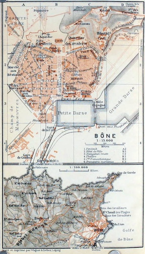
309124 M. St. Paul, junction of a branch-line to (7 M.) Randon. To the left appears the Massif du Beleliéta (876 ft.), in front of Jebel Edough (see below); then, between (127 M.) Duzerville and (130½ M.) Allélik, is seen the low Massif du Bou Hamra (499 ft.), with its very ancient iron-mines, now worked by the Mokta el-Hadid Company (p. 303).
Skirting the fringes of the hills last named the train now runs close to the Seybouse, and beyond the castle-hill of Hippo Regius (p. 311), on the left, crosses the Oued Boudjimah.
135½ M. Bona.—Stations. 1. Gare de la Comp. Bône-Guelma (Pl. A, 4), the chief station, for Constantine and for Souk-Ahras and Tunis (RR. 49, 51).—2. Gare de la Comp. du Mokta el-Hadid (Pl. A, B, 4), for the St. Charles line (p. 303).—3. Gare de la Calle (Pl. B, 4), for the light railway to La Calle (p. 131).
Arrival by Sea (comp. RR. 20, 22). The steamers of the Gén. Transatlantique (agent, De Pleurre), of the Transports Maritimes (agent, Teddé), and of the Navigation Mixte (agent, Fadda) are all berthed at the Quai Nord (Pl. B, C, 3), in the Petite Darse. Cabs, see below.
Hotels (comp. p. 174). Hôtel d’Orient (Pl. a; B, 2), Cours Jérôme*-Bertagna, with frequented restaurant, well spoken of; Hôt. Cramet (Pl. b; B, 3), Rue Prosper-Dubourg; Hôt. Continental (Pl. c; B, 2), Passage des Thermopyles (entrance next the Hôt. d’Orient), with good restaurant, déj. 2, D. 2½ fr., plain; Hôt. Moderne, Rue des Volontaires, new.
Cafés. Café St. Martin, Cours Jérôme-Bertagna; Brasserie du Petit Gambrinus, Rue du Quatre Septembre.
Post & Telegraph Office (Pl. B, 3), Place de la Poste.
Banks. Banque de l’Algérie, Comp. Algérienne, Crédit Lyonnais, and Crédit Foncier d’Algérie et Tunisie, all in the Cours Jérôme-Bertagna.—Booksellers. Faure (Legendre), cor. of Rue St. Augustin and Rue du Quatre Septembre; Borel & Langlade, Cours Jérôme-Bertagna.
Baths. Euvremer, Rue Damrémont; Bains Maures (comp. p. 175), Rue Bélisaire.—Sea Baths. Grenouillère (p. 310), in the Avant-Port; Plage Chapuis and others at St. Cloud-les-Plages (p. 311).—Theatre (Pl. 4; B, 2), Cours Jérôme-Bertagna.—Races, 24th April.
Cabs (stand, Cours Jérôme-Bertagna). Drive 1 (and back 1½) fr.; first hr. 2, each addit. hr. 1½ fr; half-day 8, whole day 15 fr.—Omnibus from the Cours Jérôme-Bertagna to the Plage Chapuis, etc.
Consuls. British Vice-Consul, H. A. Scratchley, Rue du Rempart 3.—U.S. Consular Agency, Rue Thiers.
One Day. Forenoon, Harbour, Cours Jérôme-Bertagna, Hippo Regius (pp. 310, 311); afternoon, Cap de Garde or Bugeaud (p. 311).
Bona, French Bône, Arabic Enneba (pop. 42,900, incl. 28,300 Europeans, mostly French, 11,200 Mohammedans, and 1700 Jews), on the W. side of the Gulf of Bona (p. 128), a fortified town, is the chief seaport of Algeria after Oran and Algiers and the most important outlet for the produce of the département of Constantine, such as phosphates (p. 315), iron (comp. pp. 310, 314), zinc, cork, cattle, and cereals. Besides its fine harbour, the town offers no sights; but it deserves a visit especially in winter, for the sake of its pretty situation at the foot of Jebel Edough (3307 ft.; p. 169), not far from the picturesque Cap de Garde.
Bona lies on the small Anse du Cassarin, about 1¼ M. to the N.E. of Hippo, which was one of the chief Phœnician colonies on the coast of N. Africa. Under Masinissa (p. 321) Hippo was the capital of Numidia, and under the Roman empire, when it was called Hippo Regius, it was the richest port on the N. coast next to Carthage and rivalled Cæsarea (p. 244). 310Here in 393 met a council of over three hundred bishops, who for the first time recognized the present canon of the New Testament. On that occasion St. Augustine (born in 354 at Thagaste, p. 313), attended as a presbyter and co-bishop. Chief among the four ‘Latin fathers’ and a keen opponent of the Donatists (p. 322), St. Augustine, after his conversion at Milan by St. Ambrose (387), settled at Hippo, where he was bishop from 395 to 430, and died there during the siege of the town by the Vandals. After its destruction by Genseric and the downfall of the Vandals, whose king Gelimer (p. 322) sought his last asylum on Mt. Edough, Hippo arose from its ruins once more under the Byzantines, but it succumbed to the assaults of the Arabs in 697 and was thenceforth entirely abandoned.
The present town of Bona, founded later by the Arabs on the slope of the Kasba hill, was seized by the Genoese in the 15th cent. for the sake of its valuable coral-fishery. After the conquest of Tunis (p. 332), it was occupied for a short time by the Spaniards in 1535, and afterwards temporarily by the Compagnie d’Afrique from Marseilles. In 1837, soon after the entry of the French (1832), the old Kasba, built under Charles V., was blown up, and since then the native quarter has been modernized in French fashion.
The *Harbour, which has been so improved of late years as to rival that of Algiers, consists of three basins. The Petite Darse (Pl. B, C, 3), 27 acres in area, the old inner harbour, lies near the railway-stations and the mouth of the Seybouse; the Grande Darse (Pl. C, D, 3, 2; formerly the outer harbour), 170 acres in area, is a new basin between the Môle Cigogne (Pl. C, 3) and the small creek of Grenouillère (sea-baths); the Avant-Port is a new outer basin of nearly 100 acres adjoining the Pointe du Lion. The outer entrance to the harbour, 270 yds. wide, between the Jetée du Lion, 1200 yds. long, and the Jetée Sud (Pl. C, D, 4, 3), 1800 yds. long, is difficult of access during N. or N.E. gales. The inner entrances, through the Jetée Babayaud and at the Môle Cigogne (see above), are only 77 yds. wide. The Quai Nord (Pl. B, C, 3) in the Petite Darse is for the large French passenger-steamers, the Quai Ouest (Pl. B, 3) for phosphate, and the Quai Sud (Pl. B, C, 4) for the iron-ore from the mine near Aïn-Daliah (p. 303). Adjoining the last quay and bordering the new reclaimed lands (82 acres) is the new Quai aux Phosphates (Pl. C, D, 3, 4), to be used for the phosphate depots and for the Ouenza iron ores (comp. p. 314).
The broad Cours Jérôme-Bertagna (Pl. B, 2, 3; formerly Cours National), the main street of the town, with the pretty grounds of the ‘Square’, skirts the W. side of the native quarter.
To the W., in the European quarter, are the covered Marché (Pl. B, 2), the interesting Fondouk (Pl. 1, A 2; native market), and, in the Boul. des Jujubiers, the Marché aux Grains (Pl. A, 3).
Outside the W. gates, Porte des Karézas (Pl. A, 3) and Porte Randon (Pl. A, 1), are the Marché aux Bestiaux (Pl. A, 2; Thurs.) and the grounds of the Square Randon (Pl. A, 2).
The Native Quarter, where also the Jews reside, is intersected by the Rue St. Augustin (Pl. B, C, 2).
311From the Boul. Victor-Hugo (Pl. B, C, 2), on the N. side of this quarter, we may mount in 10 min. to the Colline de la Kasba, or Colline des Santons (358 ft.), crowned by the Kasba (Pl. C, D, 1; no admittance). The pine-clad slope is skirted by the pretty Boul. des Caroubiers (Pl. C, D, 2, 1).
A beautiful walk may be taken from the Porte des Caroubiers (Pl. D, 1) on the busy *Chemin de la Corniche, round the E. side of the Batterie du Lion, always skirting the shore and passing many villas with luxuriant gardens. It leads to the N.W. to the suburb of (2½ M.) St Cloud-les-Plages, on the Baie des Caroubiers, with its sea-baths (p. 309). In clear weather a pleasant drive may be taken past the little Baie des Corailleurs and the old Fort Génois to (7 M.) the Cap de Garde. At the Semaphore (519 ft.), above the lighthouse, we enjoy a delightful view of the bay.
From the Faubourg Ste. Anne (Pl. A, 1) a hill-road with fine views, but almost shadeless as far as the (5 M.) Col des Chacals (1578 ft.), ascends in windings to (9 M.) Bugeaud (2809 ft.; Hôt. Fuster, Hôt. Kittler, Hôt. Cronstadt, etc.), a favourite summer resort, beautifully situated among woods of cork-oaks. In clear weather the *Panorama from (1½ hr.) Kef Seba (3307 ft.), the summit of Mt. Edough, embraces the whole coast from the bay of Stora (p. 128) to the Kroumirie (p. 326).
The dusty Route de Constantine (Pl. A, 4) leads through the S. town-gate to a (12 min.) Bridge the foundations of which are Roman, spanning the Oued Boudjimah (p. 309). Between this brook and the Seybouse, whose mouth once lay farther to the S.E. and was used as a harbour, extended the site of Hippo Regius (p. 309). The road straight on, beyond the bridge, leads to the (ca. 5 min.) Fortin, which together with the castle-hill (see below) formed the nucleus of the Roman town. Here once lay the Roman villa quarter. Excavations in the former Jardin Chevillot (adm. 50 c.), now belonging to the town, have brought to light several Roman columns and mosaics (Apollo and the Muses, Triumph of Amphitrite, etc.), the foundations of a small early-Christian basilica, and notably a fragment of wall, about 22 yds. long, composed of enormous blocks of granite, 10–13 ft. long, 39 in. thick, and 27 in. high. This last is probably the oldest and most interesting specimen of Phœnician building in Barbary. In the adjoining property of Mme. Dufour part of the foundations of a Roman villa and superb mosaics have been laid bare. Among the latter are a very lifelike representation of a hunt, fishing-scenes, houses of a town, etc. (admission kindly granted). Of the Ancient Theatre a few steps only now exist.
To the right, just beyond the Boudjimah bridge (see above), diverges the Chemin de Beleliéta, whence after 9 min. a fine road leads to the right to the old Castle Hill (181 ft.). On its slope lie the Roman Cisterns of Hippo, resembling in plan those of Bordj el-Djedid (p. 350), but modernized in 1893 for the waterworks of Bona (small fee for admittance). As Lalla Bouna, a famous saint, 312is supposed to have been buried here, the spot attracts Mohammedan pilgrims on Fridays, when they may be seen picturesquely grouped round the bronze Statue of St. Augustine (1843).
The castle-hill is crowned with the handsome Basilica of St. Augustine, founded by Card. Lavigerie (p. 346), and built by Abbé Pougnet in 1885–1900 in a semi-Oriental style, on the model of the cathedral of Carthage (p. 347).
The Interior is unfinished. Over the high-altar is preserved a highly-revered relic of St. Augustine, whose bones were carried in 496, during the Vandal period, by fugitive Catholic bishops to Sardinia, whence they were removed to Pavia by the Longobard king Liutprand in 722. In front of the church we have a fine view of the coast, with its dunes, as far as Cape Rosa (p. 131).
From Bona to St. Charles (Constantine), see p. 303; to Souk-Ahras, see R. 49; to Tunis, see R. 51.
49. From Constantine or Bona viâ Duvivier to Souk-Ahras (Tebessa, Tunis).
From Constantine to Souk-Ahras, 134 M., railway in 7–9¼ hrs. (24 fr. 30, 17 fr. 35 c., 13 fr.). Change at Duvivier. Railway Restaurants at Le Khroub, Duvivier, and Souk-Ahras.
From Bona to Souk-Ahras, 66½ M., railway in 3¼–5¼ hrs. (11 fr. 95, 8 fr. 55, 6 fr. 40 c.).
Constantine, and thence to (101 M.) Duvivier, see p. 297 and R. 48.—From Bona to (34½ M.) Duvivier, see pp. 309, 308.
We cross the Seybouse and follow the narrow dale of the Oued Melah to the S.E., with its fine growth of underwood. 107½ (or 40½) M. Medjez-Sfa (476 ft.); the village (758 ft.) lies to the right, on the Souk-Ahras road. We then mount to (113 or 46 M.) Aïn-Tahamimine (about 1100 ft.), with its eucalyptus groves.
The finest part of the line lies between this point and Laverdure. We cross the ravine of the Oued Cherf by a viaduct. 116 (or 49) M. Aïn-Affra (1739 ft.). We ascend the hill-side to the N.E., partly through plantations of young cork-trees and underwood, and then on the crest of the hill turn sharply back to the S.W. Below lies the line just traversed. At several points we obtain a splendid view of the distant hills of the Beni Salah (p. 308). Among the cork-trees appear the first evergreen oaks.