65. From Tripoli to Alexandria viâ Benghazi and Derna.
Reading edition
Steamboats (agents at Tripoli, see p. 406; at Alexandria, see p. 432). 1. German Levant Line (cargo-boats), three times monthly (80 marks).—2. Steamers of the Banco di Roma (p. 406) fortnightly viâ Malta, Benghazi, Derna, and Solum.—Between Tripoli, Lebida (occasionally), Mesurata, Benghazi, and Derna there plies a fortnightly steamer of the Società Nazionale (comp. R. 66).
Tripoli, see p. 406. Skirting the flat, sandy coast, with its numerous oases, including that of Tajûra (p. 411), we pass the small Râs Sotara, Râs el-Hamra (‘red cape’), and Râs Ligata.
In the fertile undulating plain to the E. of the small port of Ligata (lighthouse; sailing-boat from Tripoli in about 7 hrs. if the wind is favourable) lies Lebida, Lebda, or Khoms (pop. 3500; Brit. vice-cons.), in its oasis, a poor little seaport (for alfa) with open roads, relics of old fortifications, and an Italian school.
About 2 M. to the S.E. of Lebida lies the site of Leptis Magna, which fell into decay after the first irruption of the Arabs. In ancient times it was one of the richest trading towns in N. Africa. It was the starting-point of the coast-road to Carthage (see p. 407) and also of the Limes Tripolitanus, the Roman frontier-wall, which down to the conquest of the Garamantes (p. 407) and the Gætuli in the 2nd and 3rd cent. A.D. protected the province of Africa against the Sahara tribes. The ancient harbour, with its massive quays, at the mouth of the Kinyps, which was a copious stream in the Roman age (now a scanty brook, the Oued Lebda), is completely choked with sand. The once famous oasis and the grand ruins of the time of Septimius Severus (p. 407) also, except the triumphal arch (comp. pp. 315, 316), are almost entirely buried in sand.
On the rocky coast, which here endangers navigation, we next pass the Râs et-Tabia, adjoined by the little port of Marsa Ugra, and then, situated in the oasis near the Râs es-Sahal, Slîten or Zelythen (pop. 7000), a seaport for alfa. Beyond the Râs el-Ihûdi we sight Cape Mesurata, the ancient Promontorium Trikeron (‘triple horn’) or Cephalus, a striking landmark.
The small port of Mesurata or Misrâta (pop. 3000), in its little oasis of palms, fruit, and olives, is noted for its carpets and woven stuffs.
Leaving the coast we now steer to the E. across the Syrtis Major, or Gulf of Sidra, the largest on the N. African seaboard.
The town of Benghazi or Bengâsi (Albergo Maffei, near the harbour, Italian; Brit. consul, J. F. Jones; pop. 20,000, incl. 1200 Europeans, mostly Maltese and Greeks, and 2500 Jews; garrison 3000) is the capital of the Turkish province (mutessariflik) of Benghazi or Barca, which was separated from Tripolitania in 1869. Its dazzling white houses extend beyond the isthmus of the Sebkha or salt-lake (with its large evaporating grounds) and over the broad corn-growing coast-plain bordering the plateau of Merj (p. 414). The large Gasar or castle, now the seat of the governor 413(mutessarif), with barracks, together with the lighthouse and a windmill, form the chief landmarks as we make for the harbour.
The harbour, much silted up and very imperfectly protected by an unfinished breakwater, is sometimes rendered inaccessible for months in winter by the prevailing W. gales. The steamers have to lie to, under steam, some 3 M. off the coast, and passengers are landed in lighters or in rowing-boats.
The chief sight is the Market Quarter, where caravans from the interior are sometimes met with. The minarets, as at Tripoli, are in the Turkish style. The European colony is mainly Maltese, Greek, and Italian. The Italian School is attended chiefly by Jewish children. A branch of the Banco di Roma (p. 406) and an Italian Post Office have been recently established.—To the E. of the town is a beautiful Palm Grove.
To the N.E. of Benghazi lie the ruins of Euhesperidae, or Berenice, as the town was called after the wife of Ptolemy III. Euhesperidæ, famed in Greek myth for the gardens of the Hesperides, was the westmost seaport-town of Barca, the ancient Cyrenaica, a fissured hill-region rising in terraces from the sea, which was colonized in the 7th cent. B.C. by Greeks, mostly Dorians from Thera (p. 417) and Crete (p. 415). From its loftily situated capital Cyrene (p. 411), one of the richest and most brilliant cities in the Greek world, Greek culture spread rapidly over the whole coast-region, where the numerous seaports acquired also great wealth through the caravan-traffic with the interior. For a time (about 400–330 B.C.) the Cyrenians succeeded in repelling the attacks of the Carthaginians with their mighty fleet, but in 322 they succumbed to Ptolemy I. (p. 433), who united the different parts of the district under the name of Pentapolis (‘five cities’). In 96 B.C. this region along with the Marmarica (p. 415) fell into the hands of the Romans, and it was united by Augustus with Crete as a Roman province. In the great revolt of the numerous Jews who had settled in Egypt and Barca in the Ptolemaic age, 200,000 Greeks and Romans are said to have perished in Trajan’s reign. This terrible disaster was followed by the irruption of Berber tribes and of Arab marauders, and later (after 1551) by the misgovernment of the Turks. The ruin of the country was completed by a gradual subsidence of the coast which seriously prejudiced navigation. Though well supplied with rain, extremely fertile, and not too hot in summer, this region is now but thinly peopled (about 500,000), and the only towns of any size are Benghazi, Merj (p. 414), and Derna (p. 414). The highlands are occupied by hordes of nomadic Arabs, who often defy the Turkish authorities, and who are largely under the influence of the fanatical brotherhood of the Senussîyeh. The convents of the sect serve also as caravanserais. European goods are conveyed by the caravan-route to Kufra, the headquarters of the sect, and thence to equatorial Africa. Fire-arms are frequently smuggled into the country, especially from Greece. The chief exports are cattle (to Malta, Syracuse, etc.), goatskins, barley (to England), wool (to Marseilles and Genoa), and butter (to Constantinople). Large flocks of sheep are driven overland into Egypt.
Beyond Benghazi the steamer rounds Râs Adrian; whose name recalls the town of Adrianopolis founded by Hadrian. On a height, farther on, appears Tokra, a poor village near the ruins of the Greek twin-towns of Tauchira (Teuchira) and Arsinoë.
The next place on the coast, at the foot of a chain of high hills overgrown with brushwood, is Tolmeita (Ital. Tolemáide), the ancient 414Ptolemais or Tolometta, now the site of imposing *Ruins (Greek, Roman, and early-Christian). The Greek Kothon was the harbour of Barca, a thriving Greek colony on the margin of the plateau, about 15 M. inland, founded about 540 B.C. and temporarily destroyed by the Persians in 510. The town was still a place of some importance in the middle ages as a military station and a resting-place for Mecca pilgrims, but now, under the name of Merj or Medinet el-Merj, which has been given to the whole province, it has become a poor little Turkish garrison-town, inhabited by Arabs and Jews. No trace of its ruins is left.
Passing the rocky islet of Sarat and Râs el-Hamâma, the ancient cape Phycus, we reach the bold Râs Sem, the northmost point of Barca, about 10 M. to the N.W. of Cyrene (see below).
In a small plain on the coast, between the Râs Sem and Râs el-Hilil (the ancient Naustathmus), lies the poor seaport of Marsa Susa, recently colonized by Moslems from Crete. Near it are the ruins of Apollonia (later Sozopolis), once the harbour of Cyrene, but destroyed by the silting up of the coast.
From Marsa Susa a mule-track ascends to the S.W., through valleys with luxuriant vegetation and venerable olive-groves, past several ancient rock-hewn Granaries, and past a *Necropolis with countless rock-tombs, to (3–4 hrs.) the ruins of Cyrene (2002 ft.; now Krennah or Gurena), lying on the edge of a lofty plateau, with fine views all around. This was the capital of the Cyrenaica, founded near the fountain of Cyra about 620 B.C., but already spoken of in the 4th cent. A.D. as ‘urbs deserta’. The ruins have not yet been scientifically explored, but there are traces of streets, and, beneath a mantle of dense vegetation, scanty remains of the acropolis, the temples, and a Roman circus. Near them is a convent of the Senussîyeh, to which unbelievers are not admitted.
About 10 M. to the S.E. of Marsa Susa, on the caravan-route to Guba (or Mara), once lay the town of Ghermes, whose *Ruins are the best preserved in the Cyrenaica (town-wall, forum, stadium, etc.).
Beyond the bay of Marsa el-Hilil the coast is again rocky. Near a beautiful, richly wooded ravine are the ruins of Erythrum. We next steer past Râs Turba and then round the little Tsor Kersa Islands and the Râs Boasa (lighthouse).
Derna (pop. 4000), the Darnis or Darnae of antiquity, a small seaport to the E. of the headland, but entirely destitute of a harbour, is now the chief trading town in E. Cyrenaica. Vessels anchor in the open sea, over a mile from the landing-place. Near the Turkish fort and the custom-house are remains of American fortifications (comp. p. 408) and a wireless telegraph-station.
The town itself lies on a plateau in the finest *Coast Oasis of Barca (yielding dates, figs, almonds, tobacco, etc.). In the principal square, near which the camel-caravans from the interior encamp, 415is the unpretending residence of the Turkish kaimakam. The shops in the busy market-street are mostly owned by Arabs and Greeks.
Beyond the Râs et-Tîn (Gr. Chersonesos), the coast recedes far to the S. The Gulf of Bomba, with its rocky islands, here forms a large natural harbour, open towards the E. only. Beyond Menelaus Island (now Susra Mesrâta) once lay the Portus Menelai. The Platea Island near it received from Thera, about 640 B.C., the first Greek colony in the Cyrenaica.
We next skirt the Marmarica; the coast-region between the gulfs of Bomba and Solum. In the deep-set bay of Tobruk (the ancient Antipyrgos) it possesses the best natural harbour between Bizerta and Alexandria, frequented chiefly by sponge-fishers.
The featureless and inconspicuous coast of Egypt is bounded by the low white dunes near the borders of the Libyan desert. Lastly we steer across the broad so-called Arabian Gulf, between the Râs ed-Dabba and the Nile Delta (p. 418), and enter the harbour of Alexandria (comp. p. 418).
66. From Tripoli to Constantinople viâ Derna and Crete.
Between Tripoli and Constantinople there is a fortnightly service by the Società Nazionale (Line VIII: Catania, Syracuse, Benghazi, Constantinople; comp. R. 64). Dep. from Tripoli every second Mon. aft., from Mesurata Tues. morn., from Benghazi Thurs., from Derna Frid. noon, from Canea Sat. night, from Candia Sun., from Smyrna Mon. midnight, arr. at Constantinople Wed. morn. (returning from Constantinople Mon. night, arr. at Tripoli the second Wed.); fare 117 fr. 60 or 78 fr. 40 c.—From Canea to the Piræus (for Athens) there are corresponding steamers of the Russian Steam Navigation & Trading Co., of the Thessalian line of the Austrian Lloyd, and of Line X (p. 493) of the Società Nazionale.
For the voyage from Tripoli to Derna, see R. 65. The steamer next touches at Crete (Gr. Krētē, Turk. Kirid, Ital. Candia), the fourth-largest island in the Mediterranean (5402 sq. M.; 303,550 inhab.), formerly Turkish, but nominally independent since 1908.
Nearing the island we first sight the Aspra Vuná (Madaraes Mts., 7907 ft.), generally snow-clad, the ancient Leuka Orē (White Mts.). The vessel steers round Cape Krio, the S.W. point of Crete, and Cape Busa, the N.W. point, and passes the island of Grabusa.
We next proceed to the E.N.E., past Kisamo Bay and Cape Spada (Psakon), the N. point of the island. Beyond the cape opens the broad Bay of Canea (Gr. Chanía).
In favourable weather the steamer anchors in the open roads of Canea (Hôt. de France, pens. 8–10 fr.; Hôt.-Restaur. Bristol, pens. 5–8 fr.; at both it is advisable to ask charges; Brit. cons.-gen., R. Peel; pop. 21,000), the capital of Crete, on the site of Kydonia. The remains of the Venetian fortifications are interesting. Fine 416view from the lofty reservoir of the waterworks. Most of the consuls reside at Chalepa, the E. suburb.
In stormy weather the steamers round the broad headland of Akrotiri (once Kyamon) and anchor in Suda Bay, the only good harbour in the island. (Road to Canea.)
After leaving Canea and passing Cape Drépano we have a pleasant view of Harmyro Bay and Rethymno, Ital. Rétimo (pop. 9300), the ancient Rhithymna, now the third-largest town in Crete. In the heart of the island tower the Psiloriti Mts., the ancient Ida, often snow-clad, culminating in the Stavros (8065 ft.).
Farther on we pass Cape Stavros, an important landmark. We then steer to the S.E., between Cape Panaghia and the barren island of Dia, Ital. Standia (870 ft.), where vessels seek refuge from northerly storms, into Candia Bay and anchor in the roads a little off the quay (lighthouse).
Candia (Hotels, both near the landing-place: Cnossos, pens. 9–15 fr., with restaurant; Angleterre, rooms only, unpretending; advisable to ask charges at both; Brit. vice-cons., A. Calocherino; pop. 22,480), Gr. Herákleion, formerly Megalókastron, the seat of the Metropolitan of Crete, is said to have been founded by the Moors on the site of Herakleion, the port of Knossos. Here also the fortifications were built by the Venetians, and were bravely defended by their admiral Franc. Morosini against the Turks for three years until he had to capitulate in 1669.
We walk from the landing-place through the main street and past a handsome Venetian palace to the chief square, with the Morosini Fountain. Straight on we come, at the E. end of the town, to an open space, at the N.E. angle of which is the—
*Museum, containing the splendid antiquities excavated at Knossos and elsewhere, illustrating the peculiar development of art in Crete at its prime. The oldest objects belong to the so-called island culture (3rd millenary B.C.) of the bronze period, or early and middle Minoan periods, as they are now called after Minos the legendary king of Crete. To the bronze age belong also the pre-Hellenic antiquities, those namely of the so-called Mycenæan or late Minoan period (middle of 2nd millenary B.C.), which are hardly surpassed by the creations of Greece at its zenith. Particular notice should be taken of the wall-paintings, fragments of a procession, stone vases with reliefs, ivory statuettes of bull-baiters, and the two fayence figures of a goddess grasping a snake.
From the old S. gate of Candia a road (horse 3–4 fr.) leads in less than an hour to the site of Knossos, the ancient capital of the island. The *King’s Palace, excavated here since 1898 by Mr. Arthur Evans, dates from the second or middle Minoan period, but was already half burned down in the Mycenæan period.
The steamer next crosses the Cretan Sea, to the N.N.E., to two 417islands of the Cyclades (p. 492): Anaphe (1349 ft.) and Santorin or Thira (1857 ft.), the ancient Thera. Close to Cape Oia (lighthouse) on the beautiful island of Santorin, which is the relic of an old crater (p. 492), are seen the ruins of Thera, the ancient capital.
Next, on the left, we sight the island of Iós or Niós (2408 ft.). We then pass through the strait between Amorgós (1233 ft.; lighthouse), the eastmost island of the kingdom of Greece, and the small island group of Eremonisia, flanking Naxos on the S.E. side.
The high mountains of Naxos (3289 ft.), the largest of the Cyclades, remain in sight long after we have passed the islet of Donusa (1600 ft.). The islands of Delos, once the religious and economic centre of the Cyclades, and Mykonos (1194 ft.) are only visible in the far distance in very clear weather.
The ship presently nears the W. coast of Nikaria (p. 492), an island belonging to the S. Sporades (p. 490), and then (as do also the steamers from the Levant) passes through the Strait of Chios (p. 492) and across the Gulf of Smyrna (comp. p. 530).
Smyrna, and thence to Constantinople, see pp. 530, 533–536.
67. From (Marseilles, Genoa) Naples to Alexandria and Port Said.
1174 or 1278 M. Steamers (agents at Marseilles, see p. 120; at Genoa, p. 114; at Naples, p. 137; at Alexandria, p. 432; at Port Said, p. 437). 1. North German Lloyd: (a) from (Marseilles) Naples to Alexandria, in Jan.-April, on Frid. at noon (from Marseilles on Wed. aft.) in 4 days; returning from Alexandria Wed. aft. (from Naples Sat.); fares from Naples 240–480 or 140–180 marks (from Marseilles 280–520 or 160–200 marks); (b) E. Asiatic Line. (R. 24), from (Algiers, Genoa) Naples to Port Said every second Frid. night (returning Frid.), in 4 days; fare 242 or 176 marks; (c) Australian Line (R. 21), from (Genoa) Naples to Port Said every fourth Wed. night (returning Frid.), in 3–4 days; fare 242 or 176 marks.—2. German E. African Line: E. circular tour (RR. 17, 23) from (Marseilles) Naples to Port Said every third Mon. in 4 days; W. circular tour (RR. 4, 17, 23) from Port Said to Naples every third Sat.; fare 242 or 176 marks.—3. Rotterdam Lloyd, Batavia Line, from Marseilles every second Thurs. direct to Port Said (returning Tues.) in 5 days.—4. Nederland Royal Mail, Batavia Line, from Genoa direct to Port Said in 5 days.—5. Messageries Maritimes, S. Mediterranean Line, from Marseilles direct to Alexandria (Port Said, Jaffa, Beirut, R. 72), every Thurs. noon (returning Frid. aft.), in 4 days; fare 315 or 240 fr.; return-ticket (‘interchangeable’), available also for the quick boats of the Austrian Lloyd (R. 68), 603½ or 433¼ fr.—6. Società Nazionale, Line V (Genoa to Alexandria), from (Genoa, Leghorn) Naples on Thurs. aft. to Alexandria (returning Thurs. aft.), in 4 days; fare 252 or 172½ fr.
The great liners of the P. & 0., Orient Royal, Royal Mail, White Star, Bibby, and other British companies are almost exclusively for through-passengers from Gibraltar or Marseilles to Port Said, India, Australia, etc.
From Marseilles and Genoa to Naples, see RR. 23, 24; from Naples to the Straits of Messina, see R. 27.
On the left, beyond Messina, are seen the ruins of Reggio (p. 159), at the foot of the Aspromonte, the S. point of Calabria.
418Leaving the Straits of Messina, we steer across the Ionian Sea, to the E.S.E., in a direct line for Egypt. Mt. Ætna (p. 159) remains long in sight. For two days we lose sight of land. The mountains of Crete (p. 415) are visible on the voyage to Alexandria only in perfectly clear weather; but on the voyage to Port Said we pass within a few miles of Crete and near the island of Gavdos, Ital. Gozo (1063 ft.; lighthouse), which flanks Crete on the S.W.
On the Alexandria Voyage, nearing land, we overlook the long isthmus of Lake Mareotis (p. 432), from the sand-hill near Abusîr, on the E. shore of the Arabian Gulf (p. 415), to Ramleh (p. 436) and Fort Abukîr on the W. shore of that gulf. The chief landmarks are the lighthouse of Râs et-Tîn (p. 434) and Fort Cafarelli or Napoléon (p. 434).
We pass through the strait of Boghaz, amidst the chain of cliffs between Râs et-Tîn and the fortified Marabout Island, and sight the two lighthouses of El-Meks in succession. Lastly we steer through the outer harbour, with its breakwater, and past the New or Gabbari Mole (Môle aux Charbons), 1000 yds. long, into the inner harbour of Alexandria (comp. p. 434).
On the Port Said Voyage the flat coast of Egypt is generally approached at night. We first sight the lights of Damietta, on the E. bank of the Damietta branch of the Nile, the ancient Phatnitic Arm. This and the Rosetta arm are now the only mouths of the river, which had seven in ancient times.
A conspicuous landmark is Fort Jemil, between the former Mendesian and Tanitic mouths. It rises on the low downs flanking Lake Menzaleh (970 sq. M.), the largest lagoon in the Nile delta.
The entrance to Port Said (p. 436), 766 yds. in breadth, is marked by a lighthouse, several minor lights, and a number of buoys. On the W. pier (r.) rises the Lesseps monument (p. 437).
68. From Venice or Trieste to Alexandria and Port Said viâ Brindisi.
Between Venice and Alexandria (1423 M.), Società Nazionale (Line VII: Venice, Alexandria, Port Said) on the 14th and 28th of every month (returning 1st and 15th), viâ Ancona, Bari, and Brindisi, in 5–6 days; fare 280 fr. 95 or 191 fr. 30 c. (from Brindisi 195 fr. 25 or 132 fr. 15 c.). Agents at Venice, see p. 420; at Brindisi, p. 429; at Alexandria, p. 432.
Between Trieste and Alexandria (1383 M.), Austrian Lloyd, two lines: 1st. Quick steamer from Trieste on Thurs. noon (from Brindisi Frid. aft.), in ca. 4 days (returning from Alexandria Sat. aft., from Brindisi Tues. foren.); fare 360 or 245 fr. (from Brindisi 300 or 200 fr.). 2nd. Trieste and Syria Line (R. 72), on Sat. foren., viâ Gravosa (occasionally) and Brindisi, in 5 days (returning Thurs. aft.); fare 250 or 175 fr. (from Brindisi 200 or 135 fr.). Agents at Trieste, see p. 425; at Brindisi, p. 429; at Alexandria, p. 432.
419Between Trieste and Port Said, Austrian Lloyd, Syrian Line, see above; also the Bombay steamers (usually 1st and 16th of every month; to Port Said in 4 days), the Calcutta steamers (12th and 25th of each month; 6 days), and the Japan steamers (27th of each month; 6 days). Agent at Port Said, see p. 437.
From Brindisi to Port Said, P. & O. on Sun. morn., corresponding with Calais and Brindisi express, chiefly for through-passengers to India.
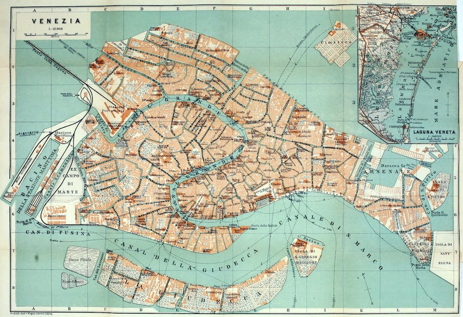
Venice.—At the Railway Station (Pl. C, D, 3; Restaurant, good), where care of heavier luggage may be left to the hotel porters, are a gondola station and two piers for the local steamers (see below).—Agents for sleeping-cars, Thos. Cook & Son and P. Faerber (see p. 420).
Arrival by Sea. The steamers anchor in the Canale di San Marco, opposite the Punta della Salute (Pl. G, 6). Custom-house examination on board. Gondola tariff, see below.
Hotels. Hôt. Royal Danieli (Pl. a; H, 5), on the Riva degli Schiavoni with its fine views, R. 7–30, B. 2, déj. 4, D. 7–10, pens. 15–25 fr.; *Hôt. de l’Europe (Pl. b; G, 6), on the Canal Grande, entrance Calle del Ridotto, R. 5–8, B. 2, déj. 5, D. 7, pens. 14–18 fr., frequented by American and French travellers; Grand-Hôtel (Pl. o ; F, 6), on the Canal Grande, entr. Via Ventidue Marzo, Ramo Minotto 2322, R. 7–30, B. 1½, déj. 4, D. 7 fr.; *Gr.-Hôt. Britannia (Pl. c; G, 6), also on the Canal Grande, entr. Corte Barozzi, similar charges; four high-class houses.—Less pretending: *Gr.-Hôt. d’Italie (Pl. h; G, 6), in Campo San Moisè and on the Canal Grande, R. 3½–15, B. 1½, déj. 3½, D. 5–6 fr., often full; *Grand Canal Hotel & Monaco (Pl. l; G, 6), on the Canal Grande, entr. Calle Vallaresso, R. from 5, B. 1½, déj. 4, D. 6 fr.; *Hôt. Regina (Pl. t; G, 6), also on the Canal Grande, entr. Calle Traghetto, R. 5–18, B. 1½, déj. 3½, D. 5 fr., frequented by English and American travellers; Hôt. de Milan & Bristol (Pl. u; G, 6), also on the Canal Grande, entr. Calle Traghetto, R. from 4, B. 1½, déj. 3–3½, D. 4½–5 fr.; Hôt. Beau-Rivage (Pl. r; H, I, 5), Riva degli Schiavoni, R. from 4, B. 1½, déj. 4, D. 5 fr., patronized by English and American travellers.
Restaurants. *Bauer-Grünwald, Via Ventidue Marzo, adjoining the Gr.-Hôt. d’Italie; Pilsen, in the Moderne Hôt. Manin, N.W. corner of the Piazza of St. Mark.
Cafés. Florian, Aurora, Quadri, all in the Piazza of St. Mark.—Tea Room. Ortes, Via Ventidue Marzo 2288.
Gondolas, the famous and picturesque boats which are the cabs of Venice, have their chief station on the Molo (Pl. H, 6; p. 422). Tariff: in the town, per hour, 1–2 pers. 1½, 3–4 pers. 2, 5–6 pers. 2½ fr. (after dusk ½ fr. extra); half these charges for each addit. ½ hr.; from the Molo to the sea-going steamers, or the reverse, 20 c. each passenger; trunk 20, small packages 5 c.—A boat with two gondolieri costs double. (As a rule one, ‘basta uno’, is enough.) In case of dispute with the boatmen, often insolent and especially towards ladies travelling alone, a vígile municipale (policeman) may be applied to.
The Local Steamers (Vaporetti Comunali), which do not carry luggage, ply (except in fog) on the main line through the Canal Grande every 10–15 min., from 6 a.m. till midnight; fare 10, to the Lido 20 c. (money changed on board; fare paid on landing). The chief landing-stages (Pontoni), beginning from the station, are: 1. Scalzi (Pl. D, 3), near the exit from the station; 2. Cerva, Riva del Carbón (Pl. G, 4), for the Rialto bridge (p. 421) and streets (p. 421) leading to St. Mark’s; 3. San Tomà (Pl. E, 5), for the church of the Frari (p. 422); 4. Accadémia (Pl. E, 6), for the picture-gallery (p. 422); 5. San Marco (Pl. G, 6; near the Calle Vallaresso), for St. Mark’s; 6. San Zaccaria (Pl. H, 5), for the Riva degli Schiavoni and St. Mark’s; 7. Giardini Pubblici (Pl. L, 7); 8. Lido (p. 424; April-Oct. only). In the reverse direction the steamers call at the Riva del Carbón (Pl. G, 4) instead of Cerva, and at Santa Lucia, close to the entrance to the railway-station (see above), instead of Scalzi.
A minor line connects the Riva degli Schiavoni (comp. Pl. H, 5, 6) with the islands of San Giorgio Maggiore (Pl. H, I, 7; p. 424) and Giudecca; in April-Sept. every ½ hr., in winter hourly.
420A third line plies from the Riva degli Schiavoni (dep. near the Ponte della Paglia, Pl. H, 5, 6) direct to the Lido, every 20–30 min. Ticket 15, return 25 c.; or, incl. adm. to bath-house 40 c., incl. bath 1 fr. 30 c.
Post Office. Fóndaco dei Tedeschi (Pl. G, 4; p. 421), near the Rialto bridge, 8 a.m. to 9 p.m.; poste restante in the court, on the left.—Telegraph Office (Pl. G, 6; also branch post-office), Bocca di Piazza, behind the W. side of St. Mark’s Piazza.
Banks. Banca Commerciale Italiana, Via Ventidue Marzo 2188; Società Bancaria Italiana, San Marco, Bocca di Piazza 1239; Guetta (American Express Co.), Campo San Moisè; Thos. Cook & Son, see below.—Bookseller. Istituto Veneto di Arti Gráfiche, Piazza San Marco 40.
Tourist Agents. Thos. Cook & Son, Piazzetta dei Leoni 289 (N. side of San Marco); P. Faerber, in Hôt. d’Italie (p. 419), also town-agent for the railway.
Steamboat Agents. North German Lloyd, Piazza San Marco 118; Hamburg-American (for winter pleasure-cruises by ‘Meteor’), P. Faerber, see above; Società Nazionale, Campo Morosini 2802; Austrian Lloyd, for the Venice and Trieste Line (p. 425), in the Piazzetta (p. 423); Hungarian Croatian Co., Thos. Cook & Son (see above).
Consuls. British, E. de Zuccato, Traghetto San Felice, Grand Canal.—United States Consul, J. V. Long, Campiello Querini Stampaglia 5257.
Churches. English (St. George’s), Campo San Vio 731; Presbyterian, Piazza of St. Mark 95.
One Day may suffice for a hurried glance, but a week or more should if possible be devoted to this unique city. Sail through the Grand Canal; inspection of the piazza and the church of St. Mark and the Doges’ Palace (p. 423).—Of the Churches St. Mark’s (p. 423) is open throughout the day, Santi Giovanni e Paolo (p. 424) and Frari (p. 422) save from 12–2 (adm. in the afternoon, till their restoration is completed, 50 c.). The Doges’ Palace is open on week-days, 9–3 (adm. 1 fr., or incl. visit to the Archæological Museum and the Prigioni 2½ fr.), on Sun. and holidays 10–2, free. Academy (p. 422) on week-days 9–4 (adm. 1 fr.), on Sun. and holidays 10–2, free.
Venice, Ital. Venezia, once the most brilliant commercial city in the world, now a provincial capital, with 148,500 inhab., of whom one quarter are practically paupers, is a commercial and naval port. It lies 2½ M. from the mainland in the lagoons, a shallow bay 25 M. long by 9½ M. broad, separated from the Adriatic by narrow sandy strips of land (lidi). The city is built on piles, on 117 islets, and is intersected by over 150 canals, which are crossed by 378 bridges. The interior of the town consists of a labyrinth of narrow streets and lanes, some of them scarcely 5 ft. wide. The centre of traffic is the Piazza San Marco (‘la Piazza’), with the adjacent Piazzetta. The other open spaces are called campi or campielli. The local name for a street is calle or salizzada, and for a narrow canal rio.
The tribe of the Veneti, the ancient inhabitants of N.E.Italy, were of Illyrian race, but became Romanized in the 3rd cent. B. C. The havoc committed on the mainland by the barbarian Huns compelled the inhabitants of the coast to seek refuge in the islands of the lagoons, where in 697 they formed the Venetian League, headed by a doge (dux). In 811 Rivoalto (now Venice) became their capital. Aided by its close connection with the Byzantine Empire (p. 541), the town rose to be a rival of Genoa in its important traffic between East and West. In its art also Venice was under Oriental influence throughout the middle ages. After the conquest of Constantinople by the great doge Enrico Dandolo 421in 1204, the lion of St. Mark laid his mighty talons on the coasts and islands of Greece and Asia Minor. On the Italian continent also the republic gradually extended its conquests to Bergamo.
The 15th cent. saw the zenith of the republic’s glory, when her fleet commanded the whole of the E. Mediterranean. But after their capture of Constantinople in 1453 the Turks began to menace the Venetian supremacy. The discovery of America and of the new sea-routes to India carried the world’s traffic into new channels, while her continental possessions involved her in the wars between the rival powers of France, Austria, and Spain. Her protracted conflicts with the Turks led in 1718 to the final loss of all her Oriental possessions, and in 1798 her political independence was destroyed by the French. From 1814 to 1866 Venice belonged to Austria, and since 1866 has formed a part of the kingdom of Italy, under whose auspices her trade has somewhat revived.
The *Canal Grande or Canalazzo, the main artery of Venice, intersects the city from the Railway Station (Pl. C, D, 3) to the harbour (Canale or Bacino di San Marco, Pl. G-K, 6, 7), from N.W. to S.E., and resembles an inverted S in shape. The voyage through it by steamer (p. 419; 25 min.) or by gondola (p. 419; 1 hr., preferable) conveys a most striking impression of the magnificence of mediæval Venice. The canal is bordered with fine old guild-houses, sumptuous churches, and stately palaces of the 12–18th cent., and each of its bends reveals a new and picturesque vista.
Left. Right.
Chiesa degli Scalzi (Pl. D, 3; church of the barefooted friars), in the highly ornate baroque style (1649–89).
Fóndaco dei Turchi (Pl. E, 3; ‘trade hall of the Turks’), a late Romanesque edifice (11th cent.), restored in 1861–9, now the Museo Civico.
*Palazzo Vendramin-Calergi (Pl. E, F, 3), the most beautiful early-Renaissance palace in Venice (1509), in which Richard Wagner died in 1883.
Palazzo Pésaro (Pl. F, 3), the most brilliant example of late-Renaissance (1679), now the Gallería d’Arte Moderna.
*Cà Doro (Pl. F, 3), the most elegant Gothic palace (15th cent.).
Fóndacodei Tedeschi (Pl. G, 4; p. 420), once the warehouse of the Germans (1505).
The *Ponte di Rialto (Pl. G, 4; ‘Rivo Alto’, the ancient name of Venice; comp. p. 420), is a marble arch of 29½ yds. span and 74 ft. in breadth, flanked with shops (1588–92).
Near the bridge are the steamboat-piers of Cerva and Riva del Carbón (p. 419), whence the Mercería (Pl. G, 4, 5), a street of shops, and the Calle dei Fabbri (Pl. G, 5) both lead in 5 min. to St. Mark’s.
422
Pal. Loredan (Pl. F, 5) and Pal. Farsetti, once Dándolo, both Romanesque (12th cent.).
*Pal. Grimani, high-Renaissance, Sanmicheli’s masterpiece (16th cent.). Pal. Papadópoli (16th cent.).
Pal. Pisani (a San Polo), Gothic (15th cent.).
Pal. Corner-Spinelli, early-Renaissance, in the style of the Lombardi. Pal. Grimani, high-Renaissance (16th cent.).
Near it is steamboat pier San Tomà (Pl. E, 5; p. 419), for the old Franciscan church *Frari (Pl. E, 5; adm., see p. 420; ticket valid also for San Tomà), in the Gothic style (1380–1417), the resting-place of many eminent Venetians, with admirable altar-pieces by Giov. Bellini and Titian (temporarily in San Tomà, close by; adm. 9–5, ticket 50 c. admitting also to the Frari church).
*Pal. Fóscari (Pl E, 5), Gothic (15th cent.).
Pal. Rezzonico (Pl E, 6), built in 1680. Robert Browning died here in 1889.
Between the Campo San Vitale (Vidal) and the Campo della Carità is the Ponte di Ferro or dell’Accadémia (Pl. E, 6).
Near the bridge is steamboat pier Accadémia (p. 419) for the *Accadémia di Belle Arti (Pl. E, 6), containing admirable Venetian pictures (G. Bellini, Carpaccio, Titian, P. Veronese). Adm., see p. 420.
Pal. Cavalli (Pl. E, 6), now Franchetti, Gothic (15th. cent.).
Pal. Corner della Cà Grande (Pl. F, 6), by Jac. Sansovino (1532).
Pal. Contarini-Fasan (Pl. F, G, 6), Gothic (14th cent.). *Santa Maria della Salute (Pl. F, G, 6), by Bald. Longhena (17th cent.); fine pictures by Titian in the sacristy.
Dogana di Mare (Pl. G, 6), custom-house (1676–82), on the point between the Grand and the Giudecca canals.
Giardino Reale (Pl. G, 6), or royal garden, behind the Procuratie Nuove (p. 423).
Molo (Pl. H, 6), adjoining the Piazzetta (p. 423).
From the Molo, or from one of the steamboat-piers (p. 419) of San Marco (Pl. G, 6) or San Zaccaria (Pl. H, 5), we next visit the 423**Piazza di San Marco (Pl. G, 5), the centre of the traffic of the city. Even now this far-famed piazza (182 yds. long, 100 yds. wide at the E. end, 61 at the W. end; paved with slabs of trachyte and marble) conveys an admirable idea of the ancient glory of Venice.
On the N. and S. sides of the piazza rise the Procuratíe, once the residences of the nine procurators or highest officials of the republic. The Procuratíe Vecchie, on the N. side, were erected in 1480–1517. The Procuratíe Nuove, now used along with the adjacent old Library (see below) as a royal palace, were begun by Vinc. Scamozzi in 1584. The Atrio or Nuova Fábbrica, on the W. side, dates only from 1810. The groundfloors of these buildings, flanked with arcades, are now occupied by cafés (p. 419) and shops.
The old Campanile di San Marco, at the corner of the Old Library, collapsed in 1902, but has been rebuilt. The top of the tower (adm. 15 c.) commands a fine and extensive *View. The Torre dell’ Orologio, a clock-tower built in 1496–9, adjoining the Old Procuratie, forms the entrance to the Mercería (p. 421).
The church of **San Marco (Pl. H, 5), which is said to contain the bones of St. Mark, was begun in 830, rebuilt after a fire in 976, and restored after the middle of the 11th cent. in the Byzantine style. The ground-plan (83½ yds. long, 56¾ yds. broad in front) is in the form of a Greek cross (with equal arms), crowned with five domes. The front arm of the cross is flanked with a colonnade. Outside and inside the church is adorned with over five hundred marble columns, mostly Oriental, and with mosaics, chiefly of the 10–16th centuries. The Gothic additions to the façade (15th cent.) enhance its fantastic charm. Over the main portal are four antique bronze-gilt horses from Constantinople.
The Interior is wonderfully impressive. The beauty of the outlines and the magnificence of the decoration are equally striking. The priceless Pala d’Oro, which forms the altar-piece, from Constantinople (1105), is shown on week-days (11–2; ticket, 50 c., admits also to the Tesoro in the right transept, 11–2).
Adjoining the Piazza of St. Mark, on the side next the lagoon, is the *Piazzetta (Pl. H, 5, 6). The *Librería Vecchia, or old library, now part of the royal palace (see above), by Jac. Sansovino (1536–53), is one of the most beautiful secular buildings in Italy. The adjacent Zecca (mint) now contains the famous library of San Marco. On the opposite (E.) side of the square rises the—
**Doges’ Palace (Palazzo Ducale; Pl. H, 5), which is said to have been founded in 814 as the residence of the first doge. It was rebuilt after the fires of 976 and 1105, and has since been repeatedly restored and altered. The Gothic exterior is flanked with two superb arcades with pointed arches; the W. front dates from 1423–8; the S. front, next the lagoon, is of the 14th century.
The Porta della Carta, the late-Gothic chief portal, next to the church, leads into the quadrangle of the palace, where the 424façades, though still partly Gothic, show the influence of the new Renaissance style. In the interior (adm., see p. 420) we visit the central and upper floors, containing the state-apartments which were redecorated after the fires of 1574 and 1577, a brilliant example of the Venetian late-Renaissance and rococo art. The countless pictures by Titian, Paolo Veronese, Jac. Tintoretto, and other masters, proclaim the ancient glory of Venice. (Guide unnecessary. Catalogues for public use on week-days.) The groundfloor contains the Archaeological Museum (antiques, Renaissance sculptures, etc.).
At the E. end of the Molo (p. 422) the Ponte della Paglia (Pl. H, 5, 6), which crosses the Rio di Palazzo, affords a good view of the ‘Bridge of Sighs’ (Ponte dei Sospiri; Pl. H, 5), specially interesting to readers of Childe Harold. The latter bridge connects the Doges’ Palace with the Prigioni di San Marco.
The contiguous Riva degli Schiavoni (Pl. H, I, 5; ‘quay of the Slavonians’) forms the sunniest promenade in the town. To the left, nearly opposite the Monument of Victor Emmanuel II., a narrow lane leads to the church of San Zaccaria (Pl. H, I, 5; adm. in the afternoon 50 c.), built in 1458–1515. Over the second altar on the left is a Madonna by Giov. Bellini (1505).
A few paces to the W. of the church is Campo San Provolo. The street of that name to the right, the first bridge to the left, and then the Calle Corte Rotta and the Ruga Giuffa (Pl. H, 5) lead to Santa Maria Formosa (Pl. H, 4; knock at W. portal; gratuity 25–30 c.), with the famous *St. Barbara by Palma Vecchio.
From the Campo Santa Maria Formosa we follow the Calle Lunga to the E., and near the end of it the Calle Bragadin to the left (N.) to the—
Campo Santi Giovanni e Paolo, with the *Monument of Colleoni (Venetian condottiere, d. 1475), the grandest equestrian statue of the Italian Renaissance, by the Florentine Andrea Verrocchio.
The church of *Santi Giovanni e Paolo (Pl. H, 4; adm. see p. 420), once the church of the Dominicans and the burial-church of the doges, erected in the Gothic style in 1330–90, is quite a museum of Venetian sculpture. The finest monument is that of Andrea Vendramin (d. 1478; in the choir, on the left), by Tullio and Ant. Lombardi and Al. Leopardi.
On the S. side of the Canale di San Marco (p. 421), reached by ferry from the Molo (‘traghetto’, 1–2 pers. 15, 3–4 pers. 20, 5–6 pers. 30 c.), or more quickly by steamer from the Riva degli Schiavoni (see p. 419), are the island and the Benedictine church of San Giorgio Maggiore (Pl. H, 7; if closed, ring on the right), built by Palladio (1565) and Ant. Palliari. The Campanile, 197 ft. high (ascent to the left of the choir; easy wooden stairs), offers a superb **View of the city, the lagoons, and the sea, embracing in clear weather the Alpine chain far away to the N. (finest in the early morning or just before sunset).
425The Lido, the most fashionable sea-bathing place in Italy (height of season July and Aug.), is reached either by the direct steamers or by those coming from the railway-station (p. 419, 420). An electric tramway connects the pier with the Bath Establishment (café-restaurant) and with the large hotels on the shore.—See also Baedeker’s Northern Italy.
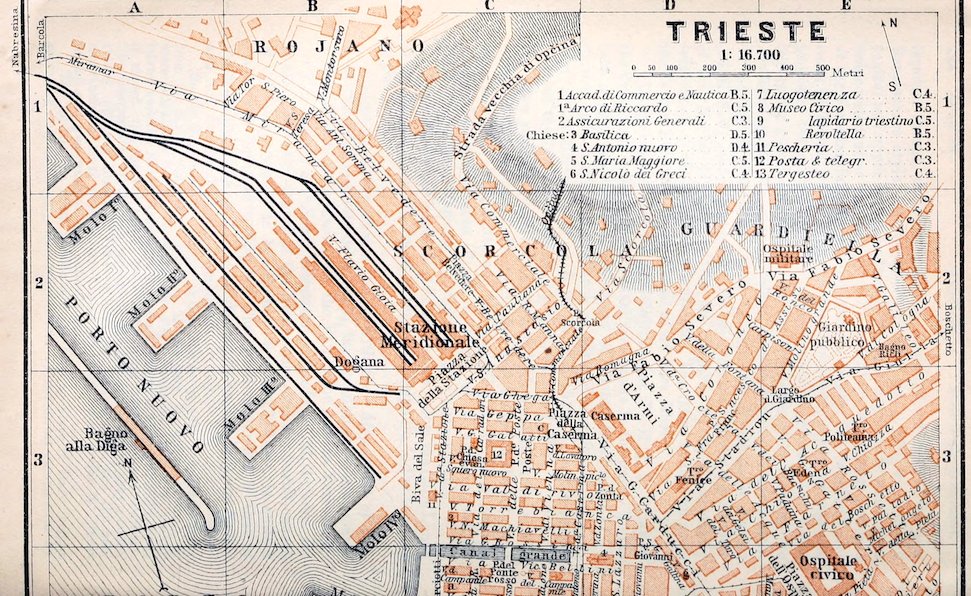
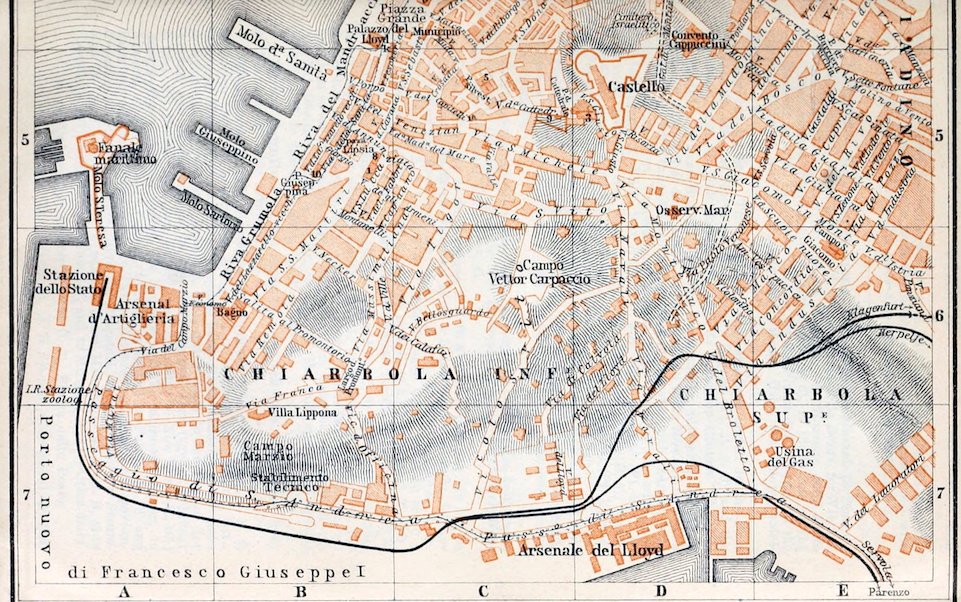
Trieste.—Railway Stations, 1. Stazione Meridionale (S. Station; Pl. B, C, 2; buffet), 10 min. to the N. of the Piazza della Borsa, for Vienna, Abbazia and Fiume, and Cervignano (Venice).—2. Stazione dello Stato or di Sant’ Andrea (State Railway Station; Pl. A, 6), at the S. end of the Old Harbour (p. 426), 15 min. to the S.W. of the Piazza della Borsa, for the Tauern Railway, and for Assling and Vienna. Cabs, see below; hotel-omnibus 1 K.
Arrival by Sea. The Austrian Lloyd steamers anchor in the New Harbour (p. 426), at Moles I-III, near the Dogana (Pl. B, 2, 3) and the S. Station, or at the Molo San Carlo (Pl. B, 4; excursion-steamer ‘Thalia’).
Hotels. Grand-Hôtel, Riva dei Mandracchio, adjoining the Lloyd Palace (p. 426), a first-class house, to be opened in 1911; Hôt. de la Ville (Pl. a; C, 4), Riva Carciotti, with first-class restaurant, high charges, variously judged; Hôt. Volpich all’ Aquila Nera (Pl. d; C, 4), with good café-restaurant, R. 3–8 K, B. 1 K 20 h, D. 3 K, Hôt. Toniato (Pl. h; C, 4), R. 3–10 K, both Via San Nicolò, good; Hôt. Balkan (Pl. c; C, 3), Piazza della Caserma, R. from 3 K, B. 70 h, D. 2 K 80 h; Hôt. Vanoli (Pl. k; B, 4, 5), Piazza Grande 2; Hôt. Delorme (Pl. b; C, 4), Via del Teatro 5; Hôt. Central (Pl. f; C, 4), Via San Nicolò 15, R. from 2 K 50–4 K 50 h, B. 1 K 20 h.
Cafés. Caffè degli Specchi, Caffè al Municipio (in the town-hall), Orientale (in the Lloyd Palace), all in Piazza Grande; Stazione, Piazza della Stazione.
Restaurants at the hotels. Also, Restaurant Dreher, Via della Cassa di Risparmio (Pl. C, 4), near the Old Exchange (p. 426); La Cooperativa, Piazza San Giovanni 5 (Pl. D, 3, 4).
Cabs. From or to the stations 1 K 60 h (9 p.m. to 6 a.m. t2 K); in the inner town per drive with one horse 1 K (at night 1 K 20 h), farther out 1 K 40 or 1 K 60 h; by time: ½ hr. 1 K 20 h, at night 1 K 60 h, ¾ hr. 1 K 60 or 2 K 20 h, 1 hr. 2 K or 2 K 80 h, each ¼ hr. more 50 or 60 h (with pair, 1 K 40 or 1 K 60 h; 2 K 20 or 2 K 40 h; 2 K 80 or 3 K 20 h; 70 or 80 h). Trunk 50 h; small articles carried inside free, outside 20 h.
Tramways from the Boschetto (beyond Pl. E, 2) viâ the Piazza della Borsa and Passeggio di Sant’ Andrea (p. 427) to Servola (p. 427); from the S. Station to Barcola (p. 427), etc.—Electric Hill-Tramway (views on left, best to sit backward), from the Piazza della Caserma (Pl. C, D, 3) viâ (2½ M.) Obelisco (80 h) in ½ hr. to (3¾ M.) the rail, station of Opčina (p. 427; 1 M. to the S.W. from the S. Station).
Motor Omnibus in the forenoon, on week-days only, every hour to Miramar (p. 427; return-fare 3 K).
Steamboat Lines. Austrian Lloyd (offices in Lloyd Palace, Pl. B, 4) to Venice (daily in summer, in 4–6½ hrs.; in winter Tues., Thurs., Sat., returning Mon., Wed., and Frid.); quick boats to Alexandria; other lines to Syria and to Port Said (comp. p. 418); quick boats to the Piræus (for Athens) and Constantinople (R. 78), etc.; Cunard Line (agents, Schröder & Co.), viâ Fiume, Palermo, Naples, and Gibraltar to New York (R. 16); Austro-American Line (office Via Molin Piccolo 2) to Buenos Ayres, to Almeria, Cadiz, and Las Palmas, to New York, and to Patras (R. 78) and Palermo; German Levant Line to Tunis, Algiers, and Oran; Hungarian-Croatian Co. (agent, Maule, Riva dei Pescatori 16) and Croatian Steamboat Co. to Fiume.—Local Steamers (from Molo San Carlo, Pl. B, 4) to Barcola (p. 427), half-hourly in summer, and to Miramar (p. 427) twice daily.
Post & Telegraph Office (Pl. 12; C, 3), Piazza delle Poste.
Consuls. British Consul-General, J. B. Spence; vice-consul, N. Salvary.—United 426States Consul, M. G. Hotschick; vice-consul O. Demartini.—Lloyd’s Agent, R. Greenham, Via San Lazzaro 15.
English Church Services, in the Via San Michele 1714, every Sun. at 11 a.m. and 6 p.m.
Trieste (pop. 221,000, Italians, Slovenians, and Germans; in 1758 about 6400 only), the Roman Tergeste, the chief seaport of Austria and in the E. Mediterranean, lies on the E. shore of the Bay of Trieste, at the head of the Adriatic and at the foot of the Karst or Carso Plateau (1945 ft.), which is often visited by N.E. gales (Bora). Having become the heiress of Venice Trieste was a free harbour from 1719 to 1891; in 1833 it became the seat of the Austrian Lloyd, the oldest and one of the greatest of the steamboat companies in the Mediterranean. The harbour is entered by ca. 12,000 vessels annually (imports 573, exports 508 million florins). The new Tauern Railway, completed in 1909, the direct route to the Baths of Gastein, the Tyrol, and thence to Germany, is expected to give a new impulse to the trade of the city.
The Harbour comprises the Porto Vecchio (Pl. A, B, 4), sheltered by the Molo Santa Teresa (Pl. A, 5; lighthouse) of 1756, the Porto Nuovo (Pl. A, 1–3), with its four moles and a breakwater 1186 yds. long, constructed in 1867–83, and the Porto Nuovo di Sant’ Andrea or Francesco Giuseppe Primo (Pl. A, B, 7). The last, in the Bay of Muggia, was completed in 1910. Between the Porto Nuovo and Porto Vecchio is the Canal Grande (Pl. C, 4), completed in 1756, for small vessels only.
Near the old harbour are the two busiest squares in the town, the Piazza Grande (Pl. B, C, 4) and the Piazza della Borsa. In the Piazza Grande are a marble Statue of Charles VI. and the Maria Teresa Fountain (1751). On its E. side rises the Municipio or town-hall (Pl. C, 4). Next to the sea are pleasure-grounds; at the S. end of these is the Lloyd Palace (Pl. B, 4); at the N. end is the Luogotenenza (or governor’s residence; Pl. 7, C, 4).
To the N. of the Piazza Grande are the Theatre (Teatro Comunale Giuseppe Verdi, Pl. C, 4) and the Tergesteo (Pl. 13; C, 4), the new exchange, built in 1852. The Borsa, or old exchange (Pl. C, 4), is now the seat of the chamber of commerce.
The Via del Corso (Pl. C, D, 4), the main street of Trieste, running to the E. from the Piazza della Borsa, separates the new town from the streets of the old town, which ascend the castle-hill. The old Castello (Pl. D, 5) now contains the barracks. Fine views are obtained from the terraces of the Convento dei Cappuccini (Pl. D, 4, 5) and of the Cathedral (Basilica San Giusto; Pl. 3, D, 5; closed 12–3), which is composed of three early-Christian churches (6th cent.), united in the 14th century.
Between the cathedral and the Piazza Grande are the open-air Museo Lapidario (Pl. 9; C, 5), Via della Cattedrale 9, and the Arco di Riccardo (Pl. 1a; C, 5), the remains of a Roman arch.
427In the Piazza Lipsia, to the S.W. of the Piazza Grande, rises the Commercial and Nautical Academy (Pl. 1; B, 5), containing the Museo Civico of natural history and antiquities. Near it is the Piazza Giuseppina (Pl. B, 5), with a bronze monument by Schilling to the Archduke Maximilian (d. 1867; see below).
Environs. By the Passeggio di Sant’ Andrea (Pl. A-E, 6, 7), past the Stabilimento Tecnico (Pl. B, 7) and Lloyd Arsenal (Pl. C, D, 7), to (2½ M.) Servola (tramway, p. 425).—By hill-tramway (p. 425) to *Obelisco (1125 ft.; Hotel), with terrace; walk thence to the N.W. along the foot of the Karst to the Belvedere (1303 ft.; fine view; best in the evening).
The *Excursion to Miramar is best made in the afternoon; the traveller should ascertain whether or not the park and château are open. The highroad (4½ M.; motor-omnibus, see p. 425) skirts the coast. We may take the train also from the S. Station to (5 M.) Miramar or to (5½ M.) Grignano and descend thence in ¼ hr. (or ½ hr.) to Miramar, or take the tramway (p. 425) to Barcola (sea-baths; Hôt. Excelsior) and walk thence to (2½ M.) Miramar (motor-omnibus 60 h). The pleasantest route, however, is that of the steamer (p. 425),—The imperial château of Miramar, on the beautiful Punta di Grignano, was built in 1854–6 by Archd. Maximilian. It was here that he accepted the imperial crown of Mexico (1864). The château, which has a charming park, is open to the public (10–12 and 3–5, in winter 2–4; adm. 60 h).
From the S. station of Opčina (pronounced Óptchina; see p. 425; ordinary trains only stop here) directly in ½ hr. (or from Trieste viâ Miramar, 10½ M. Nabresina, and 18 M. Opčina in 1¼–2½ hrs.) to (10 or 28 M.) Divača (pronounced Divátcha; 1418 ft.; Buffet, also R. 2 K 80 h, good; quarters also at the Restaurant Obersnel), station for (1 M.) Kronprinz Rudolf’s Grotto (tickets, etc. at the buffet), for the (¾ hr.) Stephanie-Warte (1428 ft.; view), and for the grand Cataracts and Caverns of St. Canzian (tickets and guides at the inn of Joh. Gombač at Matavun, ½ hr. below the Stephanie-Warte, ¾ hr. from Divača).
See also Baedeker’s Austria-Hungary.
The Italian Steamers from Venice to Alexandria usually leave the lagoons to the N. of the Lido (p. 424), avoiding Chioggia and the marshy delta of the Po. They then steer down the Adriatic Sea towards Ancona. In clear weather we obtain a superb view of the Alps, of the Euganean hills to the N.W., and of the Apennines, whose offshoots come close down to the Adriatic near Rimini.
Ancona (Hôt. Roma e Pace, etc.; Brit, vice-consul; pop. 33,300, incl. about 6000 Jews), 140 M. to the S.E. of Venice, a strongly fortified town and the busiest seaport on the E. coast of Italy, is splendidly situated between the headlands of Monte Astagno and Monte Guasco, the N.W. spurs of Monte Conero (p. 428).
The Harbour, an oval basin open towards the W., is considered the best in Italy. The well-preserved Arch of Trajan, in marble, of 115 A.D., and a Triumphal Arch of the time of Pope Clement XII. (1730–40) recall the two founders of the N. quays. The Banchina, on the E. side of the harbour, is a modern quay (1880).
From the Dogana we may walk to the E. in a few minutes to the church of Santa Maria della Piazza, with its lavishly decorated façade (1210), and to the late-Gothic Loggia dei Mercanti 428(Exchange; 1454–9). A little to the E. is the Prefettura (15–16th cent.), with its fine quadrangle and a superb Renaissance archway.
The Via del Comune, near this, leads to the N., past the Palazzo del Comune (of 1493, but much modernized), to the *Cathedral (San Ciriaco; closed 12 to 4.30), on Monte Guasco, a fine point of view. The church, in which Byzantine and Romanesque forms are mingled, dates from 1128–89; the fine porch is of the 13th century.
The Steamers round the N. pier, and beyond Monte dei Cappuccini (lighthouse) pass Monte Conero (1877 ft.; the ancient Promontorium Cunerum), crowned with a Camaldulensian monastery. This limestone mass does not form part of the Apennines, in front of which it lies, and geologically considered is perhaps, like Monte Gargano (see below), a relic of the great Dalmatian limestone tableland (p. 429).
The coast recedes. In clear weather we sight in succession the summits of the Central Apennines, snow-clad till July: Monte Vettore (8130 ft.), the highest of the Monti Sibillini, the Gran Sasso d’Italia (9561 ft.) in the Abruzzi, and the Maiella, with Monte Amaro (9170 ft.).
After some time we pass the four low Trémiti Islands, the mythical Insulae Diomedeae, and then the rocky island of Pianosa (ancient Planasia), beyond which we sight Monte Gargáno (3464 ft.; Mons Garganus), once, as late as the tertiary age, an island separated from the mainland by a strait.
Off the lighthouse of Vieste, on the E. side of the peninsula, we steer away from the Bay of Manfredonia and due S.E. to—
Bari (Hôt. Cavour, Corso Vittorio Emanuele; Caffè del Risorgimento, at the hotel; Brit. vice-cons. and U. S. cons. agent; pop. 73,400), the ancient Barium, a provincial capital and the largest trading town in Apulia. As in the time of Horace, this is the part of the Adriatic where fish are most abundant.
From the Porto Nuovo, on the N.W. side of the old town, Monte Gargano, often cloud-capped, is visible even in rainy weather. The small Porto Vecchio, on the E. side, admits small craft only.
The sights of the old town are the Castle, once that of the Hohenstaufen, dating from Emp. Frederick II. (1223; now barracks and signalling station), the Cathedral, a Romanesque church of the 12th cent. modernized in 1745, and the church of San Nicóla, dedicated to St. Nicholas of Bari. San Nicola and the small church of San Gregorio near it date from the end of the 11th century.—The old town and the new (Borgo) are separated by the broad Corso Vittorio Emanuele, which ends in pleasant promenades.
Beyond Bari we skirt the coast, where in the seaports of Mola di Bari, Polignano a Mare, and Monopoli, with their white houses, we see the first signs of the Orient. The Faro di Penna, 429the lighthouse on Capo Gallo, and the lighthouses in the islands of Sant’ Andrea (see below) and Le Petagne mark the approach to (475 M.) Brindisi (see below).
The Austrian Lloyd Steamers, on leaving Trieste (p. 425), steer to the S.W. through the Bay of Trieste, avoiding the numerous bays of the N.W. coast of Istria; then, beyond the lighthouse of Salvore, the ancient Silvium Promontorium, they keep in sight of the hilly, olive-clad W. coast of Istria. We pass the small coast-towns of Umago, Cittanuova, and Parenzo (ancient Parentium), then the lighthouse on the Marmi Bank, the Canal di Leme, a kind of fiord, backed by Monte Maggiore (4580 ft.), and the harbour of Rovigno, sheltered by cliffs (scogli).
Beyond the cliff of San Giovanni in Pélago (lighthouse) we pass the Isŏle Brioni, where the Venetians once quarried stone for their palaces and churches. Fine view of the deeply cut bay of Pola, the chief naval seaport of Austria, used also by the Romans of the imperial age as a naval harbour.
Beyond Cape Promontore (ancient Polaticum Promontorium), the flat S. extremity of Istria, with a lighthouse on the Porer Cliff, a delightful view in clear weather is revealed of the Dalmatian islands, relics of the ancient Dalmatian limestone plateau, now submerged in the Adriatic. The most conspicuous are Lussin (Apsorus Insula), culminating in Monte Ossero (1929 ft.), and to the E., overtopped by it, Unie and Sansego with their lighthouses.
We pass the large islands of Lunga or Grossa and Incoronata (Celadussae Insulae), lying off the coast near Zara. A good way farther on we sight the rocky islet of Pomo, midway between Dalmatia and the E. coast of Italy; then the islands of Sant’ Andrea (1001 ft.), Busi (788 ft.; containing the Spelonca di Ballon, resembling the blue grotto of Capri), and Lissa (1920 ft.; ancient Issa), where the Austrian fleet defeated the Italian in 1866.
Between the islands of Cazza (797 ft.) and Lagosta (1368 ft.; ancient Ladesta) and the Italian island-group of Pelagosa, we may descry Monte Gargano (p. 428) to the S.W. in clear weather.
We now steer straight towards the Faro di Penna (p. 428).
Brindisi.—The Quay is on the N.E. side of the town; the Station, on the S.W. side, is ¾ M. from the quay. Between them runs the Corso Garibaldi, continued to the W. by Corso Umberto Primo.
Hotels (charges should be agreed upon beforehand). Grand-Hôt. International, at the quay, R. 5–10, B. 1½, déj. 4, D. 6, omn. 1½ fr.; Albergo Europa, Corso Garibaldi 147, R. from 2 fr.; Alb. Centrale, Corso Garibaldi 67, near the harbour; these two, with restaurants, fairly good.—Café Caprez.
Cab (bargaining necessary) from station to quay 60 c., 2 pers. 1 fr., 3 pers. 1 fr. 20 c.; ½ hr. 2, 1 hr. 3 fr.; at night 20 c. more; trunk 20 c.
Post & Telegraph Office, Corso Umberto Primo and on the quay.
British Consul, S. G. Cocoto.
Steamboat Offices. Società Nazionale, Via Margherita 32; Austrian Lloyd, Thos. Cook & Son, Strada Marina.—The steamers are generally 430moored at the quay; otherwise, landing or embarkation 60 c.—Lloyd’s Agent, Sig. Nervegna.—English Church Service in winter.
Brindisi (pop. 22,000), a quiet town, the seat of an archbishop, has been ever since ancient times an important starting-point for the East. In the middle ages its harbour was often sought by the Crusaders, and hosts of travellers now pass through it on their way to or from Egypt, India, Australia, etc. The inner harbour, sheltered from every wind, consists of two natural creeks formed by erosion; in the southmost, the Seno di Ponte Piccolo, 492 yds. long, the large steamers are easily berthed. The channel connecting the inner harbour with the outer had become choked with sand in the later middle ages, but was reopened in 1755 and lined with masonry in 1866. On the island of Sant’ Andrea, outside the harbour, rises a castle of the 15th cent., now a quarantine station.
The town offers few sights. On a height close to the quay stands a Column, 62 ft. high, with a rich capital containing figures of gods. Adjacent is the base of a second column. The unfinished inscription on the first mentions Lupus Protospatha, a Byzantine governor, who restored the town in the 10th cent. after its destruction by the Saracens. These columns are said to have marked the end of the Via Appia which led from Rome to Tarentum and Brundisium, and they perhaps bore a beacon-fire. The Gothic Castle, with its huge round towers, on the N. creek, to the W. of the town, built by Emp. Frederik II. about 1235 and strengthened by Charles V., now contains a bagno for galley convicts. The baptistery of San Giovanni al Sepolcro (11th cent.), with its fine portals and frescoes, is now a museum of antiquities. The Cathedral, in its present form, is of the 18th cent.; at the corner of a street opposite is a mediæval house with an elaborate balcony. The Norman church of San Benedetto (early 13th cent.) has an interesting side-portal and fine cloisters. Santa Lucia has a crypt with relics of Byzantine frescoes.
Leaving Brindisi the Steamer next passes through the Straits of Otranto, the entrance to the Adriatic, about 47 M. in breadth, within sight at first of the flat and marshy coast of Apulia, with the lighthouse of San Cataldo. To the E., on the coast of Albania, rise the Acroceraunian Mts. (p. 496).
Far away to the left appear the Othonian Islands (p. 496), belonging to Greece, and the W. coast of Corfu (p. 495).
Steering through the Ionian Sea we near the W. coast of Kephallenía (p. 500) and Zante (p. 502). Off the Strophades (p. 502) we sight the Messenian Peninsula, with Mt. Ægaleon (p. 502).
Beyond the Œnussae Islands (p. 493) we proceed to the E.S.E. till at length we pass the W. coast of Crete (p. 415) and the island of Gavdos (p. 418). We then lose sight of land until near Alexandria or Port Said (comp. p. 418).
431
69. Alexandra.[6]
Arrival. Most of the steamers are berthed at the quay in the inner harbour (otherwise the fare to or from the steamer is 2 pias., at night 3 pias., each trunk 1 pias.). After the formalities of the sanitary authorities are concluded, the care of heavier baggage is entrusted to one of the Arabian hotel porters, or to Cook’s agents (p. 432), who wear an official cap or badge. The inclusive charge to the hotel or to the railway-station is 15–20 pias., which through-passengers to Cairo may sometimes pay in advance at one of the tourist agencies before starting on their journey. The custom-house examination is usually lenient.
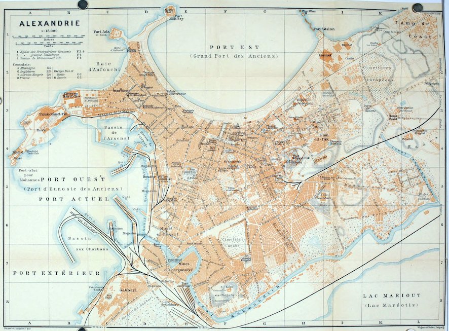
Railway Station. Gare du Caire or Bab el-Guedid (Pl. G, 5; buffet), near the old Porte Moharrem Bey.
Hotels (English style). Savoy Palace (Pl. g; H, 4), Rue de la Porte de Rosette 35, R. 40–70,. B. 10, déj. 20, D. 30, pens. 80, omn. 5 pias.; Metropole Hotel (Pl. k; F, G, 3), Rue Avéroff, near the E. harbour, R. 20–30, B. 6, déj. 15, D. 20, pens. 40–60, omn. 5 pias., well spoken of; Excelsior Hotel (Pl. a; H, 4), Rue de la Porte de Rosette 15; Grand-Hôtel (Pl. b; F, 4), Square Ste. Catherine, R. from 25, B. 6, déj. or D. 20, pens. 60–80, omn. 5 pias.; Windsor Hotel (Pl. d; G, 3), Rue Avéroff 7, near the E. harbour, R. from 17, déj. 15, D. 20, pens. from 50 pias.; Hôt. Bristol (Pl. i; G, 4), Rue de la Gare de Ramleh; Hôt. des Voyageurs (Pl. f; F, 4), Rue de l’Eglise Ecossaise 4, pens. 11 fr.; Hôt. Bonnard (Pl. e; F, 3), Rue Champollion 7, pens. from 42 pias.—Hôtels Garnis. Hôt. du Nil (Pl. h: F, 3), Rue de l’Ancienne Bourse 11; Hôt. Continental (Pl. c; F, 4), Rue de France 2.
Cafés (cup of Arabian coffee 1 pias.). Several in Place Méhémet Ali (Pl. F, 4), etc.—Confectioners. Confiserie Albengo, Rue Chérif Pacha 17; Groppi, same street, No. 33; Zola, Rue Toussoun Pacha 3; Sault, Rue Chérif Pacha 26.
Restaurants. Ristorante Firenze, Rue de la Poste 14 (Pl. F, 3, 4); Restaurant Universel, Rue de l’Ancienne Bourse 9 (Pl. F, 4); same street, Nos. 3 and 6, Old Bourse Bar and Spathis; Castelli, Rue Chérif Pacha 1.
Tramways (see Plan), all diverging from Place Méhémet Ali. Uniform fare, 1st cl. 10, 2nd cl. 5 mill., with right to one change of car.—Electric line to Ramleh (p. 436) every 5 min. till midnight (dep., see Pl. G, 3).—There are in addition several services of Motor Omnibuses plying within the town and to the suburbs.
Cabs (Arabic arabîyeh). In the town, drive of 10 min. 2 pias., with two horses 3 pias.; 20 min. 2½ or 4 pias.; ½ hr. 3 or 5 pias.; hr. 6 or 9 pias.; each addit. ¼ hr. 1½ or 2 pias.; from steamer to railway-station 3 or 5 pias. (See tariff in vehicle as to suburbs). The aid of a friend who speaks the language is desirable in bargaining for long drives.
432Post Office (Pl. F, 3), open 7–12 and 2 to 9.30. Postage, see p. 441. France has its own post-office, Rue de la Gare de Ramleh 2.—Telegraph Offices. Egyptian, Rue Tewfik Premier 1; British, Rue du Télégraphe Anglais 5 (Pl. F, 4).
Consulates. British (Pl. 6; H, 3), Rue de l’Hôpital Egyptien: consul-general, D. E. Cameron; vice-consul, E. H. Mulock.—United States, Rue Chérif Pacha 21; consul, D. R. Birch; vice-consul, F. L. Romeo.
Tourist Agents. Thos. Cook & Son, Rue de la Porte de Rosette 2; Clark, Grand-Hôtel; Hamburg-American, Square Ste. Catherine (Pl. F, 4); F. Th. Fotiades & Co., Rue Chérif Pacha 22.
Physicians. Dr. Morrison, Place Méhémet Ali; Dr. Webb Jones, Rue de Stamboul; Dr. Elkins (Government Hospital); Dr. Forster (lady-doctor); Dr. Hoddad, Rue de la Gare de Ramleh 29.
Steamboat Offices. Peninsular & Oriental, Rue Avéroff (Haselden & Co.; ‘Box 153’); Messageries Maritimes (RR. 67, 72), Ricard, Rue de l’Eglise Debbane 5; Austrian Lloyd (RR. 68, 72), Rue de la Porte de Rosette; Società Nazionale (RR. 67, 68, 72), Capt. Baldovino, Rue Sésostris 12; Khedivial Mail Steamship Co. (RR. 72, 75, 76), Rue Centrale; North German Lloyd (R. 67) and Rumanian Mail (R. 76), Müller & Co., Rue Sésostris 16; German Levant Line (R. 72), Stross, No. 11, same street; White Star, Ross & Co., Rue de la Marine; Russian Steam Navigation & Trading Co. (RR. 72, 75, 76), Reidemeister, Rue St. Marc 1.
Banks (usually 9–12 and 3–5). Ottoman, Place Méhémet Ali 5 (Pl. F, 4); National Bank of Egypt, Rue Toussoun Pacha 4 (Pl. G, 4); Anglo-Egyptian, Rue Chérif Pacha 7; Crédit Lyonnais, same street, No. 4; Bank of Egypt, Rue Tewfik 4; Deutsche Orientbank (Pl. F, 4), Rue Adib 4.
Photographs. Reiser & Binder, Rue de l’Ancienne Bourse 6 (also art-dealers); Lassave, Rue de l’Eglise Debbane 7; Fettel & Bernard, Rue Toussoun Pacha 1. Photographical requisites at Delmar’s, Rue Tewfik Premier.
Theatres. Zizinia (Pl. G, 4), Rue de la Porte de Rosette, often closed; French and Italian operas, alternating after 1st Jan. with Cairo.—Variety Theatres (all with gardens): Alhambra (Pl. G, 4); Nuovo Teatro Alhambra, cor. of Rue Misalla and Rue de la Gare de Ramleh (Pl. G, 3).—Jardin Rosette, Rue de la Porte Rosette (Pl. H, 4).
Churches. English (St. Mark’s; ‘Egl. anglicane’; Pl. F, 4), Place Méhémet Ali; chaplain, Ven. Archdeacon Ward, M. A.; services on Sun. at 8, 11, and 6.15 o’clock.—Presbyterian (St. Andrew’s; Pl. 1, F, 3, 4), Rue de l’Eglise Ecossaise; service on Sun. at 10.30 a.m.—American Mission (‘Egl. améric.’; Pl. G, 4), Rue Sidi el-Metwalli.
One Day, when time is limited. Forenoon, Place Méhémet Ali (p. 434), the Arab and Turkish Quarters (p. 434); tramway or cab to Pompey’s Pillar (p. 435); *Catacombs of Kôm esh-Shukâfa (p. 435). Afternoon, Rue Chérif Pacha (p. 435) and Museum (p. 436). A ‘billet cumulatif’ obtained at the Museum (8 pias.) admits also to Pompey’s Pillar and the Catacombs.
Alexandria, called by the Arabs and Turks Iskanderîeh, the second town of Egypt, strongly fortified, and one of the most important trading places on the Mediterranean, lies in 31° 11′ N. lat. and 29° 53′ E. long., at the W. end of the Nile Delta (p. 418), on a strip of land separating Lake Mareotis from the sea. The population is about 377,000, incl. 48,000 Europeans (‘Franks’), chiefly Greeks and Italians, but many French and Austrians and a lesser number of English and Germans. The Moslems live mostly in the N. and W. quarters (comp. p. 434), the Europeans chiefly in the E. quarter or in Ramleh (p. 436).
433Alexandria was founded in 331 B. C. by Alexander the Great, who endeavoured to blend the land of the Pharaohs with his new Greek empire. His Egyptian governor and successor, Ptolemy I. Soter (323–286), made Alexandria a centre of art and science. He founded the Museum, an institute for the promotion of science and poetry, to which the famous Alexandrine library was attached. The highly advantageous position of the town, which was connected, through Lake Mareotis, with the Nile by several navigable channels, and whose harbour (unlike the other older seaports at the mouth of the Nile) was protected by marine currents from being silted up, led to the surprisingly rapid development of its trade and prosperity under the Ptolemies. Alexandria had attained its zenith when, in 48 B. C., the Romans intervened in the quarrels between Cleopatra and her husband Ptolemy XIV. Both Caesar, who entered Alexandria in triumph after the murder of Pompey at Pelusium, and Antony were ensnared by Cleopatra. After the defeat of Antony’s partisans Augustus founded the large E. suburb of Nicopolis. When at its prime the city is said to have had a population of half-a-million inhabitants. The Greek element predominated, after which came the Egyptian, while a Jewish community had existed here ever since the time of Ptolemy I. Christianity also took root in Alexandria at an early period, having been first proclaimed here, according to tradition, by St. Mark the Evangelist.
In the time of Trajan (96–117) the revolt of the Jews, who then composed one-third of the population, gave rise to terrible bloodshed and disaster. A century later the emperor Caracalla (211–7) paid a fateful visit to the city, and, to punish the citizens for their contumacy, ordered many of them to be massacred and the famous academy to be closed. The city suffered even more severely from the persecution of the Christians under Decius (250) and Valerian (257), from the plague in the reign of Gallienus, and from its battles with the Palmyrenes (260–8). Having become, like Carthage, a stronghold of Christian erudition, Alexandria afterwards became the chief scene of the embittered controversies between Arius (d. 336), a presbyter of the city, and the ‘orthodox’ bishops Alexander and Athanasius (328–78). Even after the victory of the Athanasians at the councils of Nicæa (325) and Constantinople (381) the Arian heresy, which admitted the divine nature of Christ but denied his identity with the Father, subsisted for centuries among the Germanic tribes.
Under Theodosius I. (379–95) paganism received its death-blow, when the patriarch Theophilus waged war against all heathen temples and monuments. But the material prosperity of the city declined at the same time. The citizens were no longer able to pay for the cleansing of the Nile and the maintenance of the canals, and they were further impoverished when the patriarch Cyril banished the Jews. In 619 the Persian Chosroes made Alexandria his base for the conquest of Egypt. The country was next overrun by the hordes of caliph Omar, whose general Amr ibn el-Âsî captured Alexandria in 641. Its importance now declined still further in the same proportion as Cairo, the new capital of the conquerors, rose to wealth and importance. In 1303 and 1326 a great part of the city, with the Pharus (p. 434), was destroyed by earthquakes. Lastly, the discovery of America and of the sea-route to India completed the ruin of its trade.
About the year 1800 the population of Alexandria had dwindled to about 5000, but Mohammed Ali (p. 414) wisely laid the foundations of a new era of prosperity. He improved the harbours and constructed canals. His great work was the Mahmûdîyeh Canal (p. 434), begun in 1819, which fertilized anew the environs of the city and again connected it with the interior of Egypt, which had long been obliged to export its produce by way of Damietta and Rosetta. Subsequent rulers also were zealous for the welfare of Alexandria. During the revolt of the national party under Arâbi Bey (1882) Alexandria was bombarded by the British fleet and the European quarter was burned down, but since then the city has resumed its steady and vigorous career of progress.
434The old town of to-day lies partly on the Heptastadion, the embankment ‘seven stadia’ (about 1430 yds.) in length, which ever since the time of the Ptolemies has connected the mainland with the island of Pharos, but which in the course of centuries has been greatly widened. At the E. extremity of the island, now peninsula, rises the picturesque Fort Kâït Bey (Pl. D, E, 1), on the site of the famous ‘Pharus’, a lighthouse erected under Ptolemy II. Philadelphus by Sostratus of Cnidos, in 280–279; it was originally 400 ells (590 ft.) in height, and was deemed one of the seven wonders of the world; it is supposed to have been the prototype of the Egyptian minaret (comp. p. 445). The main or ‘great’ harbour of that period, protected by a huge embankment, is now the Port Est, the new quays of which afford a pleasant seaside walk and are being completed as a fashionable boulevard.
The Port Ouest, the ancient Eunostos (‘haven of happy return’), was little used till the later Roman age. Improved since 1871 it now consists of an inner basin of 475 acres, and a new outer harbour of 1750 acres (p. 418). From the beginning of the Gabbari Mole extend quays with warehouses along the E. side of this harbour to the Naval Arsenal (Pl. C, D, 3). Of the 2000 steamers entering the port annually more than half are under the British flag. The inner harbour is connected with the Mahmûdîyeh Canal (p. 435) by means of locks. The chief exports are cotton, cotton-seed, grain, beans, rice, sugar, onions, and tomatoes.
The Rue de la Marine (Pl. E, D, 5, 4; tramways, see p. 431) and its continuation the Rue Moutouch Pacha (Pl. D, 4, 3) form one of the chief approaches to the peninsula of Pharos (see above). Between the viceregal Palace of Râs et-Tîn (Pl. A, B, 3) and the Port Est lies the Turkish Quarter, with its pretty houses and a few gardens.
The Rue Râs et-Tîn, the main street of the N. quarters, leads past the Government Buildings (Pl. D, E, 3), to the S.E., to the Arab Quarter, lying on the ancient Heptastadion (see above) and containing several Sûks or markets, which present an interesting picture of Oriental life.
The Rue de France (Pl. E, F, 3, 4), the S.E. prolongation of the Rue Râs et-Tîn, leads to the Place Méhémet Ali (Pl. F, 4), the focus of European life, planted with trees and adorned with a Statue of Mohammed Ali (p. 444) on horseback. The chief buildings here are the Palais de Justice, the Bourse, and the English Church. The last is adjoined by St. Mark’s Building, belonging to the British community and used as a school and for official purposes. From the W. harbour the Place Méhémet Ali is reached by the Rue Bab el-Karasta (Pl. E, 5) and Rue Anastasi (Pl. E, F, 5, 4), skirting the lofty Fort Cafarelli or Napoléon (Pl. E, 5; signalling station).
A few paces to the S. of the Place Méhémet Ali lies the triangular 435Square Ste. Catherine (Pl. F, 4), named after the Catholic Church of St. Catharine. From this point we walk (or take a car or motor-omnibus, see p. 431) to the S.E. through the Rue Abou Dardah (Pl. F, 4, 5) and Rue de la Colonne Pompée (Pl. F, G, 6, 7), past the Sidi Amr Mosque (Pl. G, 6) and a large Cimetière Arabe (Pl. F, 6, 7), to a bare hill, on the right, covered with débris.
Here in the time of the Ptolemies rose the Serapeum, the most superb temple in the city, dedicated to Serapis, god of the lower regions. On the same site now stands Pompey’s Pillar (Pl. F, G, 7; adm. 3 pias.; see also p. 432), the grandest memorial of antiquity in the city. We ascend by steps to the plateau. All around are traces of recent excavations, chiefly bringing to light relics of Roman edifices. The column, composed of red granite from Assuan, is 88 ft. high including the mutilated base. It is perhaps a Christian monument of victory, dating from the time of Emp. Theodosius I. (p. 433), signalizing the destruction of the Serapeum (391). In the middle ages it was supposed to be the tomb of Pompey.
We follow the Rue Karmouss (Pl. G, 7, 8), which leads hence to the S. to the Mahmûdîyeh Canal, and diverging to the right viâ the Rue Bab el-Melouk, we pass a small mosque and reach (10 min.) the entrance (Pl. ‘E.’; F, 8) to the—
*Catacombs of Kôm esh-Shukâfa (Pl. F, 8; ‘hill of potsherds’), an Egyptian burial-place of the 2nd cent. A.D., hewn in the rock. Adm. from 8 a.m. till dusk (5 pias.; see also p. 432).
The tombs, discovered in 1900, consist of several stories and afford an excellent example of the characteristic Alexandrine blend of the Egyptian with the Græco-Roman style. They probably belonged to some Egyptian magnate. Around the principal chambers are plainer vaults for the domestics of the family. Modern stairs ascend to the restored entrance on the hill-top. The interior is rendered accessible by wooden bridges and lighted by electricity, but is partly under water.
A spiral staircase, lighted by a large round shaft, descends near a sarcophagus-chamber of later date to two stories. From the entrance to the upper story we enter a rotunda covered with a kind of dome. On the right are two smaller vaults with niches, sarcophagi, and shelf-tombs (loculi). On the left is a large chamber, the Triclinium Funebre, used for funeral banquets.
The stairs divide farther down, affording a survey of the principal chambers, and lead round the entrance to the *Tomb Chapel on the lowest floor, with three niches for sarcophagi. Round the chapel runs a gallery, accessible from the vestibule, with 91 shelf-tombs.
An important thoroughfare, leading to the N.E. from the Rue Abou Dardah (p. 434), is the Rue Sidi el-Metwalli (Pl. F, G, 5, 4), with its continuation the Rue de la Porte de Rosette (Pl. F-I, 4, 3). These streets unite at the end of the busy Rue Chérif Pacha (Pl. F, G, 4), a street of shops, coming from the Place Méhémet Ali (p. 434). This thoroughfare corresponds with the E. half of the Dromos, the main street of the ancient city, which ended at the Canopic Gate, the site of the now removed Porte de Rosette. In the Rue du Musée, a N. side-street, is the—
436*Museum (Pl. H, 3), a building in the Greek style, which contains an extensive collection of Græco-Roman antiquities, mostly Alexandrine, found in catacombs and tombs. Adm. daily, 9–12 and 3 to 5.30, 2 pias. (see also p. 432; closed on Thurs. in summer).
From the ante-room we see the statue of Hercules in the transverse gallery between the main wings of the building (see below). The side-room contains a topographical collection. Room I (on the right). Christian antiquities, including tombstones and some of the terracotta flasks in which pilgrims brought holy oil from the tomb of St. Menas (d. 296) at Mariut.—Rooms II-V. Alexandrian coins, stamps from Greek amphoræ, etc.
Room VI. Inscriptions and tombstones. On the right, Ptolemaic *Tombstones (Nos. 83, 97, etc.), resembling those of Attica in the 4th cent. B.C.—Rooms VII-IX. Egyptian antiquities. (In Room VIII, No. 380. Fine bas-relief with a man, a harper, and singing-women.)
Rooms X & XI. Egyptian monuments and smaller sculptures. (In R. XI, No. 3704. Portrait-head in black basalt.)—Rooms XII & XIII. Portrait-busts and sculptures. (In R. XII, Case B, admirable small busts of Alexander; *66. Marble Head of Hercules or, according to others, of Zeus.)
Rooms XIV & XV. Architectural fragments. (In R. XV, No. 3, painted capitals from palaces of the Ptolemies.)—Room XVI. Sculptures.
Rooms XVII & XVIII. Small objects of art. In R. XVII glass; mummies with portraits of the deceased painted on wood (2nd cent. A.D.). In R. XVIII small clay figures of the Ptolemaic and Roman periods; among the former, *Figures of girls in the style of the Tanagra figurines.
Room XIX. A mosaic and cinerary urns from Shatbi.—Room XX. Tomb accessories.—Room XXI. Objects from tombs, including elegant bronze wreaths; terracotta figures.—Room XXII. Architectural fragments; mosaics from Canopus.
In the gallery crossing the garden is a colossal figure of Hercules.
From the Museum the Rue du Musée to the N.W., the broad Rue d’Allemagne to the left, and the Rue Missala to the right soon lead to the old Ramleh Railway Station, now used for the electric line (see p. 431) to Ramleh (i. e. ‘sand’), a villa suburb and sea-bathing place, inhabited in summer by wealthy Alexandrians and Cairenes. At San Stefano, the terminus, is the Hôtel Casino San Stefano, with a theatre and concert-rooms (adm. 5 pias.).
From Alexandria to Cairo, see R. 71.
70. Port Said.
Arrival. The steamers moor alongside the Quai François-Joseph or in the Bassin Ismaïl. If they are not berthed at the quay the fare for landing at the Custom House (Pl. 8) is 1½–2½ piastres (trunk 2, small packages 1 pias.). The North German Lloyd provides a steam-tender in winter, which lands passengers free of charge. Heavy luggage had better be entrusted to one of the hotel-porters, or to an agent of Messrs. Cook (comp. p. 431) or of the Hamburg-American Line.
Railway Station near Lake Menzaleh (p. 418), 10 min. to the W. of the Custom House.
Hotels. *Eastern Exchange Hotel (Pl. a), Rue Sultan Osman, pens. from 12s., English house; *Savoy (Pl. d), corner of Quai François-Joseph and Rue el-Tegara, with restaurant and bar, pens. from 62 pias. ; Hôt. Continental (Pl. b), Rue el-Tegara, with bar, pens. 10s. 6d.; Hôt. de la Poste (Pl. c), Rue du Nil.
Cab from the quay to the station 4 (at night 5) pias.
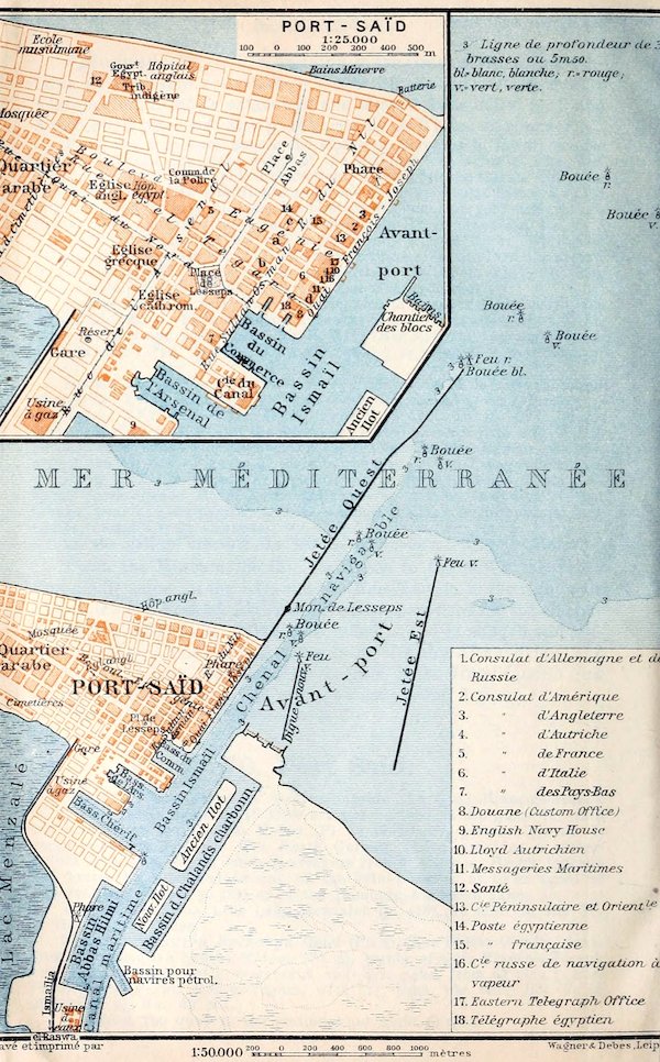
437Post Offices. Egyptian (Pl. 14) and French (Pl. 15), Rue du Nil.—Telegraph Offices. Egyptian (Pl. 18), Rue el-Tegara; Eastern Telegraph Co. (Pl. 17), Quai François-Joseph, for Europe.
Consulates at the Quai François-Joseph. British (Pl. 3): consul-general, E. C. Blech; vice-consul, T. D. Dunlop.—United States (Pl. 2): consular agent, H. Broadbent.
Tourist Agents. Thos. Cook & Son, Quai François-Joseph; F. C. Clark, Savoy Hotel; Hamburg-American Line, Rue du Nil.
Steamboat Offices. All the important companies have offices on the quay. L. Saxon & Co. (Società Nazionale) are also Lloyd’s Agents.
Banks. Bank of Egypt and Crédit Lyonnais, Rue du Nil; National Bank of Egypt, Rue Eugénie; Ottoman, Bassin du Commerce.—Money, see p. 431.
Physicians. Dr. Curling, Dr. W. Hayward (Egyptian Government Hospital); Dr. E. Cuffey (Lady Strangford Hospital); Dr. J. H. Wigham.
English Church. Church of the Epiphany (‘Eglise angl.’ on Plan), Rue el-Tegara; services every Sun. at 10.30 a.m. and 6 p.m.
Port Said (pop. 42,000, incl. 11,300 Europeans) lies at the E. end of the strip of land between Lake Menzaleh (p. 418) and the open sea, at the N. end of the Suez Canal, to which it owes its foundation. Its trade, chiefly through-traffic, is growing rapidly.
The Harbour of 570 acres has a depth of 26 ft., which is maintained by laborious dredging. It is sheltered by two massive breakwaters, the Jetée Ouest, 2460 yds. long, with a statue of Ferd. de Lesseps (1805–94), the builder of the Suez Canal (1859–69), and the Jetée Est, 1750 yds. long. The former protects it against the mud of the Nile. Between these is the Digue Nouvelle, an inner breakwater 597 yds. long, for shelter against E. winds; on the mainland opposite (to the W.) rises the *Phare, a lighthouse 174 ft. high, visible 23 M. away.
The inner harbour of 220 acres consists of the Bassin Ismaïl (with its three very shallow creeks), the Bassin des Chalands Charbonniers, and the Bassin Abbas Hilmi or Africa Basin, with the quarantine establishment.
The Rue Quai du Nord (tramway) leads to the N.W. to the Quartier Arabe.
71. From Alexandria or Port Said to Cairo.
From Alexandria to Cairo, 130 M., express in 3, ordinary train in 6–6¾ hrs.; 1st cl. 87½, 2nd cl. 44 pias.—From Port Said to Cairo, 145 M., express (with dining-car) in 4–4¼, ordinary in 5 hrs.; 96 or 48 pias.—As to transport of luggage, see p. 431.—The buffets at the intermediate stations are poor.
Alexandria, see p. 431. The Cairo railway, the oldest in the East (1855), rounds Lake Mareotis (p. 432), which during the Nile inundation rises at places to the permanent way. On the left is the Mahmûdîyeh Canal (p. 434).
On the right beyond (17 M.) Kafr ed-Dâwâr appear the first cotton-fields.—38 M. Damanhûr (pop. 22,100), the ancient Egyptian Timē-en-Hor (town of Horus) and Roman Hermopolis Parva, 438is now the capital of the province of Beheireh, which extends from the Rosetta arm of the Nile (p. 418) to the Libyan desert.
The soil becomes more fertile. Villages of wretched mud-huts and a few groups of trees appear. We cross the Rosetta Arm. 64½ M. Kafr ez-Zaiyât.
76 M. Tanta (Buffet; Hôt. Khédivial, etc.; Brit. cons. agent, E. Erba; pop. 80,000), capital of the province of Gharbîyeh, between the Rosetta and Damietta arms (p. 418), possesses a palace of the Khedive and an unfinished mosque of Seiyid el-Bedawi, a popular Egyptian saint, born at Fez (12th cent.). The great August fair (el-Mûlid el-Kebîr; ‘the great mûlid’, or nativity of the saint) is often attended by half-a-million persons, including a number of European merchants.
Farther on we pass several cotton-cleaning mills, evidencing the prosperity of this region, and then cross the Damietta Arm.
101 M. Benha (Buffet), junction of the Port Said (see below) and Suez lines, is noted for its fruit. 120½ M. Kalyûb (or Qualioub).
The Libyan hills become more prominent; so also the Mokattam Hills (p. 443) and the citadel with the slender minarets of the mosque of Mohammed Ali (p. 454). Gardens and villas appear. On the left are the site of ancient Heliopolis (p. 459; obelisk not visible), Matarîyeh with its sycamores, Kubbeh, the residence of the Khedive, and the suburb of Abbâsîyeh (p. 459).
130 M. Cairo (chief station), see p. 439.
Port Said, see p. 436. The Cairo line at first skirts the W. bank of the Suez Canal (p. 437). On the right lies Lake Menzaleh.
Beyond (28 M.) El-Kantara (‘the bridge’), the isthmus between lakes Menzaleh and Balah, traversed by the time-honoured military and caravan route from Egypt to Syria, we cross the bed of the latter lake, now largely drained.
We next cross El-Gisr (‘the barrier’), a hill 52 ft. high, between lakes Balah and Timsâh (‘crocodile’), once the most serious obstacle in the way of the canal.
49 M. Ismaîlîya, or Ismaïlia (Buffet; pop. 7000), junction for Suez, a quiet little town on the N. bank of Lake Timsâh.
The train now runs to the W. through the Arabian Desert, intersected here by the Wâdi Tûmîlât, and skirts the Ismaîlîyeh Canal (p. 454).
Near (85 M.) Abu Hammâd begins the well-watered and well-planted E. part of the Nile Delta. To the S. of the railway lies the Biblical land of Goshen (Gen. xlv. 10), which was miserably neglected during the Turkish period, but has now awakened to new life.
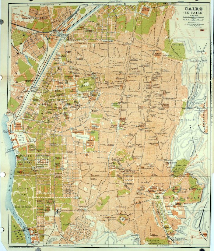
43997 M. Zakâzîk (Buffet; Brit. cons. agent, G. Diacono; pop. 60,000), capital of the E. Egyptian province of Sharkîyeh, favourably situated at the junction of several railways and on the Muizz Canal (part of the ancient Tanite arm of the Nile, see p. 418), is a rapidly improving place. It is the chief seat of the Egyptian cotton and grain trade. The large cotton-mills give some quarters of the town quite a European look.—Near Tell Basta, ½ hr. to the S.E. of Zakâzîk, are the ruins of the ancient Bubastis (Egyp. Per-Bastē, the Pi-beseth of Ezekiel xxx. 17).
116 M. Benha, and thence to (145 M.) Cairo, see p. 438.
Cairo.[7]
Railway Stations. 1. Central Station (Pl. B, 1; Buffet), for Alexandria, Port Said, and Upper Egypt, to the N.W. of the town, beyond the Ismaîlîyeh Canal, ½ M. from the Ezbekîyeh.—2. Pont Limûn Station, or Gare de Matarîyeh, adjoining the central, for Matarîyeh (Old Heliopolis), for the electric line to the Heliopolis Oasis (see p. 441), etc.—3. Bâb el-Lûk Station (Pl. B, 5), for Helwân (p. 464).—The hotel omnibuses and the porters and tourist-agents (p. 441) await the arrival of the express trains. Or an Arab porter, wearing a metal badge on his arm, may be engaged to carry luggage to an omnibus or a cab (tariff, see p. 441). Heavy luggage is taken to the hotels in separate vehicles.
Hotels (mostly in the English style and excellent, but generally crowded in Jan.-March; advisable to telegraph for rooms from Alexandria or Port Said; closed in summer or charges reduced).
In the Town: *Shepheard’s Hotel (Pl. B, 3), Shâria Kâmel, with terrace, garden, restaurant, bar, post-office, etc., pens. from 80 pias., patronized by American and English travellers; *Savoy (Pl. B, 4), Mîdân Suleimân Bâsha, pens. from 80 pias., with excellent restaurant (déj. 30, D. 50 pias.); *Semiramis (Pl. A, 5), Kasr ed-Dubara, on the Nile, with garden and roof-terrace, restaurant, post-office, etc., pens. from 80 pias.; *Continental (Pl. B, C, 3), Place de l’Opéra, with terrace, restaurant, etc., pens. from 70 pias., frequented by English travellers; *Hôt. d’Angleterre (Pl. B, 3), Shâria el-Maghrâbi, with terrace, etc., pens. 70–80 pias.—*National (Pl. B, 3), Shâria Suleimân Bâsha, pens. from 50 pias.; New Khedivial Hotel (Pl. B, 2), Shâria Bâb el-Hadîd, pens. from 45 pias.; Eden Palace (Pl. C, 3), Shâria el-Genaïneh, pens. from 50 pias., frequented by English and American travellers; Villa Victoria (Pl. B, 3; private hotel), Shâria Shawarbi Bâsha, quiet and well-situated, pens. 70 pias.; Villa Nationale, Shâria Shawarbi Bâsha (Pl. B, 3), also a private hotel, with garden and tennis-court, pens. 50 pias.; Bristol & du Nil (Pl. C, 2, 3), Mîdân el-Khaznedâr, pens. from 65 pias., commended; Métropole (Pl. B, C, 3), Hâret Zogheb, pens. 50–60 pias., well spoken of; Hôt.-Pens. Rossmore House (English), Shâria el-Madabegh 13, pens. 40–50 pias.—Hôt. des Voyageurs (Pl. B, 2), Shâria Nubar Bâsha, pens. 45–50 pias., with good cuisine, patronized by the 440French; Hôt. Royal (Pl. C, 2), Shâria Wagh el-Birket, with bodega, pens. 60 pias.; Hôt. de Londres (Pl. B, 2, 3), Shâria Kâmel, pens. 40 pias.; Hôt.-Pens. Suisse, Shâria el-Genaïneh 10 (Pl. C, 3), pens. 33–40 pias.
On the Island of Gezîreh (p. 457): *Ghezireh Palace Hotel, with restaurant, large gardens, daily concerts, etc., open Dec.-April, pens. from 80 pias. (electr. omnibus to station; motor to Shepheard’s and Semiramis Hotels frequently).
At the Heliopolis Oasis (p. 459): Heliopolis Palace Hotel, a new extensive establishment of the first class, on the Metropolitan Line (p. 441), with all modern appliances, a garden, pavilion, etc., open in winter only, pens. 80–150 pias.; *Heliopolis House, a first-class family-hotel, opposite the former, with a large terrace, restaurant, American bar, and concerts, pens. 40–50 pias.; Pens. Belle-Vue, with restaurant (déj. 12, D. 16 pias.), pens. 40 pias.
Near the Pyramids of Gîzeh (p. 461): *Mena House Hotel, with restaurant, swimming-bath, tennis-courts, golf-links, riding-track, etc., open 1st Nov. to 15th May, pens. 60–100 pias.; Sphinx Hotel, near Kafr el-Haram (p. 463), a village 10 min. to the S.E. of the tramway-station, new, pens. from 10s.
Restaurants at the hotels, with grill-rooms. Also Santi, in the Ezbekîyeh Garden, déj. 20, D. 25 pias.; St. James’s, Shâria Bûlâk, opposite the Egyptian Telegraph Office; Restaurant du Nil, Shâria Elfi Bey, déj. 14, D. 16 pias.; Hermes, Shâria Kâmel, opposite the Ezbekîyeh Garden.
Bars & Cafés. New Bar, Place de l’Opéra; Splendid Bar, Shâria Kâmel; Bar High Life, Shâria Wagh el-Birket 42.—European style, but not for ladies: Sphinx Bar, Shâria Bûlâk, with grill-room; Café Egyptien, opposite Shepheard’s Hotel, with female orchestra; Eldorado, Shâria Wagh el-Birket.—The Arabian cafés (kahwa’s) are small and dirty.
Confectioners. Lehrenkrauss, Shâria Kasr en-Nîl 34, with tearooms; Sault, Groppé, both Shâria el-Manâkh.
Beer. Restaurant Falck, Shâria el-Mahdi (Pl. B, C, 2, 3); Bavaria, Mîdân Kantaret ed-Dikkeh (Pl. B, 2), good restaurant (déj. 12, D. 15 pias.); Kemmler, in the street on the N. side of the Crédit Lyonnais (p. 442); Flasch, near the Ezbekîyeh Garden.
Tramways (fare 1 or ½ pias. unless otherwise stated; separate compartment for women). The following are the chief lines: 1. From the Atabet el-Khadra (Pl. C, 3) to Place de l’Opéra (Pl. C, 3), Shâria Bûlâk (Pl. B, A, 3), Kasr en-Nîl (Egyptian Museum), Kasr el-Aïni (Pl. A, 7), Rôda, Gîzeh Village, and the Pyramids (Mena House, see above), every 30 (aftern. every 20) min.; fare 4 or 2 pias.—2. From the Atabet el-Khadra to Bâb el-Khalk (Pl. D, 4; Arab Museum), Shâria Khalîg el-Masri, Place Seiyideh Zeinab (Pl. C, 6), Shâria Mawardi, and the Abattoirs (beyond Pl. B, C, 7), every 7½ min.—3. From the Mîdân el-Khaznedâr (Pl. C, 3) to Kasr en-Nîl, Kasr el-Aïni (Pl. A, 7), Gezîret Rôda (p. 461), Pont Abbâs II., and the Village of Gîzeh (p. 461), every 10 min.; fare 2 or 1 pias.—4. From the Mîdân el-Khaznedâr to Mîdân Bâb el-Lûk (Pl. B, 4), Mîdân Ismaîlîyeh (Pl. A, 4, 5; for the Great Nile Bridge and Egyptian Museum), Shâria Kasr el-Aïni, Fum el-Khalîg (Pl. A, 7), and Old Cairo, every 6½ min.—5. From Kasr en-Nîl (Gezîreh, p. 457) to Zoological Garden and Village of Gîzeh, every 10 min.—6. From Bûlâk (p. 454) to Shâria Abou el-Ela (Pl. A, 3), Shâria Bûlâk, Atabet el-Khadra (see above), Bâb el-Khalk (see above), and the Citadel (Place Rumeileh; Pl. E, 6), every 3 min.—7. From Zabtîyeh (Shubra), to Central Station (Pl. B, 1), Shâria Clot Bey, Atabet el-Khadra, Mîdân Bâb el-Lûk (Pl. B, 4), and Mîdân Nasrîyeh (Pl. B, 5), every 3 min.—8. From Central Station (Pl. B, 1) to Shâria Abbâs (Pl. B, A, 2, 3), Shâria Mariette Bâsha (Pl. A, 4; Egyptian Museum), Kasr en-Nîl, Mîdân el-Azhâr (Pl. B, 4; Gare de Bâb el-Lûk), every 9 min.—9. From Ghamra (to the N. of Pl. D, 1) to Mîdân ez-Zâhir (Pl. D, E, 1), Bâb esh-Sharîyeh (Pl. D, 2), Muski, Bâb el-Khalk, and thence as No. 2, every 6 min.—10. From the Atabet el-Khadra (Pl. C, 3) viâ the Place de l’Opéra, Shâria Bûlâk, Shâria Imâd ed-Dîn (Pl. B, 3, 2), Bâb el-Hadîd 441(Pl. B, 1), and Abbâsîyeh to the Heliopolis Oasis (p. 459), every 10 min.; in ca. 50 min.; fare 1½ or 1 pias.
Electric Railway (‘Métropolitain’) from the Pont Limûn Station (Pl. B, 1) every 10 min. (from 6.30 a.m. till 12 p.m.) to the Heliopolis Oasis (p. 459), in 10 min.; fares 1st cl. 2, 2nd cl. 1 pias.
Steam Ferries between Bûlâk (Shâria Abou el-Ela; to the W. of Pl. A, 3; corresponding with tramway No. 6) and Gezîreh (p. 457), and between Old Cairo (p. 460; corresponding with tramway No. 4) and the village of Gîzeh (p. 461).—Local Steamers from the Bûlâk Bridge (Pl. A, 4) to Bûlâk.
Cabs (comp. p. 431), open victorias with two horses, abound in the European quarters and tourist-resorts. Closed cabs (landaus) usually have to be ordered, and the fares are higher. The Tariff (in cab) is for 1–3 pers. (each addit. pers. 2, trunk 1 pias.) as follows:
1. Drive within a radius of 4 kil. (2½ M.) from the Administration Building (Gouvernorat; Pl. D, 4), for 1 kil. 3, each addit. kil. 2 pias.; if dismissed outside the zone named, 2 pias. more per kil.; waiting, up to ¼ hr., 2 pias.
2. By Time (Arab, bis-sâa), in town 1 hr. 10, each addit. ¼ hr. 2 pias.; per day (12 hrs.) 70 pias.
3. Longer Drives. To the Citadel 10, and back 20 pias. (incl. stay of 1 hr.); to Old Cairo 12 or 18 pias. (halt of 1 hr.); to the Pyramids 50 or 80 pias. (halt of 3 hrs.); to the Heliopolis Oasis 30 or 50 pias. (halt of 2 hrs.).
A gratuity (bakshîsh) of 5–10 per cent over the fare is usually given. Complaints, with the number of the cab and other details, should be lodged at the police-office (p. 442). During the season the demands of the cabmen are often exorbitant, but the mere mention of the dreaded word ‘karakól’ (prison) generally brings them to reason.
Motor Cabs (with taximeter): 3½ pias. for the first 1200 mètres (¾ M.), 1 pias. each addit. 400 mètres (¼ M.), waiting 1 pias. for each 5 min. In addition to these fares a surtax must be paid for each drive as follows: from or to the Mena House (Pyramids) 10 pias., Heliopolis 8 pias., Citadel, Gîzeh 5 pias., Gezîreh 3 pias.