VI. ALGERIA. (continued 2)
Reading edition
31. Prom Tlemcen to Nemours viâ Lalla-Marnia.
64 M. Railway to (36½ M.) Lalla-Marnia (two trains daily in ca. 2¼ hrs.; fares 6 fr. 65, 4 fr. 75, 3 fr. 55 c.), going on thence to (43 M.) Zoudj-el-Beghal, the terminus on the Moroccan frontier.
The Railway, admirably engineered, skirts the N. side of Tlemcen, and then, near the Bâb el-Kermâdîn (p. 193), turns to the S.E. to (3 M.) Mansura (p. 193) and crosses the Col du Juif (2664 ft.). Behind us there is a fine view of Tlemcen, while the distant view extends to the Plaine des Angad and Jebel Beni Snassen (see below). We next skirt the N. spurs of the Jebel Terni group (p. 187) and pass through superb valleys and ravines.
7½ M. Aïn-Douz. Beyond (9½ M.) Zelboun we are carried through the valley of the Oued Zitoun, one of the chief tributaries of the Tafna (p. 185).
18½ M. Turenne (1969 ft.; Hôt. Fournier and Hôt. Leclerc, poor), a thriving village in a well-watered region. Esparto is the chief export.
28½ M. Sidi-Medjahed, with a camp of wedded spahis (p. 390). 31 M. Tralimet.
36½ M. Lalla-Marnia (1197 ft.; Hôt. de France; Hôt. de la Renaissance), properly Lalla-Maghrnia, on the site of the Roman castle of Numerus Syrorum, was founded in 1844 on the occasion of the campaign against Morocco, and named after the tomb of a female saint. It is now the most important frontier-town of the province of Oran; it was made a free mart in 1895, and holds a great Sunday *Market, much frequented by Moroccans. Lalla-Marnia forms the portal of the Plaine des Angad or Plaine d’Oudjda. This great plateau is bounded on the N. by the Traras Group (p. 198) and the fertile Jebel Beni Snassen (4659 ft.), both inhabited by Berber tribes only, and on the S. by the main chain of the Tell Atlas. The old caravan route to Fez by Tâza, the key to N. Morocco, has been the scene of all the expeditions of the Arabs against Morocco ever since that of Sidi Okba in the 7th century.
From Lalla-Marnia a new road (motor-omnibus twice daily) leads to the S.W., crossing the frontier of Morocco halfway, to (ca. 15 M.) Oudjda or Ujda (2241 ft.; Hôt. Figari, good, quarters should be engaged by telegraph; pop. ca. 8000), the chief town of E. Morocco, which is said to have been founded by the governors of Tlemcen in the 10th cent., and was occupied by the French in 1814, 1859, and 1907. The picturesque town, the most fertile oasis in the Angad steppe, lies amidst orchards and olive-groves, not far from the Oued Isly, the battle-field of 1844 (p. 221). We enter the town, passing the kubba of Oudjda, by the N. gate (Bâb el-Khemis). Straight on is the French Consulate in a pretty garden, while 198to the left are the Custom House and Post Office. In the S. quarter of the town rises the Kasba or Dâr el-Makhzen, the seat of the Moroccan Amel or governor. At the N. angle of the Kasba is the Chief Mosque, dedicated to Sidi Okba, to the N.E. of which lies the Sûk (p. 335). Behind the mosque is the new Ecole Franco-Arabe. Outside the E. gate, the Bâb Sidi Abd el-Wahhâb, is the camping-ground of the caravans; and outside the S. gate (Bâb Oulad Amran), on a slight eminence 10 min. from the town, are the quarters of the French troops of occupation. The Thursday market is important. Famous horse-races in October, in connection with those of Lalla-Marnia.
For a visit to Oudjda travellers may use also the railway as far as Zoudj-el-Beghal (comp. p. 197) on the Moroccan frontier, whence Oudjda is about 8 M. distant.
The Road to Nemours (diligence) leads to the N. from Lalla-Marnia through a hilly region, crosses the Oued Mouïlah, a tributary of the Tafna, near the Hammam Sidi-Cheikh, a small bath with saline springs (91° Fahr.), and then winds up, past the Kubba Sidi-Abdallah (on the left), towards the Traras Mts., which are famed for the beauty of their outlines. In the Jebel Masser, near the top of the pass, the Col de Bab-Taza (2664 ft.), is a cadmium mine, worked like the neighbouring mines of Jebel Maaziz by a Belgian company.—We now descend to the N.E. in many windings, passing not far from the onyx-quarries near the Kubba Sidi-Brahim, into the valley of the Oued Zebaïr.
53½ M. (from Tlemcen) Nédroma (1312 ft.; inn; pop. 4900), superbly situated in a fertile basin, is an antiquated little Berber town, with fine mediæval mosques. The *Market (Mon. and Thurs.) is worth seeing for the sake of the picturesque costumes of the peasants who flock to it from the mountains around. Home-industries are much in vogue in the environs.
The Jebel Fillaoussen (3727 ft.), the highest of the Traras group, to the E. of Nédroma, commands an extensive view, embracing in very clear weather the Sierra Nevada in the far N.
The road soon leaves the Oued Zebaïr and turns to the N.W. to the lower course of the brook, which takes the name of Oued Tléta farther on, and from the influx of the Oued Taïma to the sea that of Oued el-Mersa.
In the upper valley of the Taïma, on the slope of Jebel Kerkour (1884 ft.), are the Kubba Sidi-Brahim, where a small French force under Col. de Montagnac was almost entirely cut to pieces in 1845, and the Kubba Sidi-Tahar, where Abd el-Kâder (p. 221) surrendered in 1847. The former event is recalled by a monument in the Vallée des Jardins, ¾M. to the S. of Nemours.
64 M. (from Tlemcen) Nemours (Hôt. de France; pop. 3900), a pleasant little town, noted for its mild and healthy climate, was founded in 1844 on the site of the Roman Ad Fratres, a name derived from two rocks near the beach. The banana culture thrives in the environs. On the Plateau de Taount (407 ft.), to the N.E. of the town, are the ruins of Djemâa el-Ghazaouât (‘marauders’ community’), once a Berber village, but afterwards a notorious den of pirates (p. 221).—Nemours is a steamboat station (comp. R. 18).
199
32. From Oran to Beni-Ounif de Figuig (Colomb-Béchar) viâ Damesme and Perrégaux.
396 M. State Railway. Direct communication with dining-car (déj. 3, D. 3½ fr.) and sleeping-car (12 fr. extra) three times a week only (Tues., Thurs., and Sat.; returning Sun., Wed., and Frid.); express viâ (129½ M.) Saïda to (305½ M.) Aïn-Sefra in 16 hrs.; thence by ordinary train to Beni-Ounif in 5¼ hrs.; trains start from the Gare d’Arzew at Oran (p. 175). As far as (55½ M.) Perrégaux we may travel by the Oran and Algiers train on the main-line (R. 33), noting that the stations there are 550 yds. apart (omn. 25 c.). Fares to Aïn-Sefra 39 fr. 35, 29 fr. 50 c. (sleeping-car, 1st cl. only, 12 fr. extra; 2nd cl. similar to Engl. 3rd); to Beni-Ounif 50 fr. 95, 38 fr. 20 c. (return-ticket, valid 16 days, 71 fr. 30 or 53 fr. 50 c.).—A good supply of copper coins will be found very useful.
The journey from Oran to the Sahara is most interesting, as it carries the traveller from the seaboard through a cultivated region, across the Tell Atlas to the Hauts-Plateaux, and then over the Sahara Atlas to the margin of the desert. The only good intermediate resting-place is Aïn-Sefra. A stay of several days at Beni-Ounif will be found pleasant, especially in spring. The oasis of Tiout is now eclipsed by that of Figuig, one of the most beautiful in the Sahara. The line goes on from Beni-Ounif to Colomb-Béchar, its present terminus.
Oran, see p. 175. Our train crosses the Algiers main-line (R. 33), passes the suburb of Victor-Hugo and the Daya Morselli (p. 185), and runs to the E. through vineyards, fields, and dwarf-palm underwood in succession, and then past the S. base of Jebel Kahar (p. 184) to (12½ M.) Fleurus.
17½ M. St. Cloud (502 ft.; hotel) lies pleasantly on the spurs of Jebel Kristel, 6¼ M. to the S.E. of Kristel (p. 184). 21 M. Renan-Kléber (433 ft.). The village of Kléber (505 ft.; Hôt. Voinson) lies 2 M. to the N.W., at the foot of Jebel Orouze (2070 ft.; semaphore), with its large quarries of white, yellow, and red marble (‘rosso antico’).
26 M. Damesme, on the Bay of Arzew, the ancient Laturus Sinus. The village lies above the station, to the S.
A Branch Line (3 M., in 12–15 min.) connects Damesme with Arzew or Arzeu (7 ft.; Hôt. de la Nièvre; Hôt. des Bains; Brit. vice-consul, A. Gautray; pop. 6000), a small seaport at the foot of Jebel Sicioun (532 ft.), whence a goods-line runs to the S. to the (9 M.) salt-works on the Lac Salin d’Arzew, or El-Mellaha. The harbour, naturally one of the best and most sheltered in Algeria, but as yet little used, has been improved since 1906. From here chiefly alfa (p. 171) is exported to Great Britain and Germany.
From Damesme the train runs to the S.E., close to the shore. 28 M. St. Leu (177 ft.; Hôt. de l’Europe). To the S.E. of the village of St. Leu, and 1 M. from the station, is the Berber village of Bettioua, near which are the scanty ruins of Portus Magnus, the only Roman settlement on the bay of Arzew.
34½ M. Port-aux-Poules (Etablissement Thermal), with sulphur-baths, a sea-bathing place in summer. The train skirts the narrow strip of sand-hills and passes the mouth of the Macta.
20037 M. La Macta, a village at the N. end of the Marais de la Macta, or swamps of the river-plain of the Sig (p. 206) and the Habra, very malarious in summer, is connected by a branch-line with (7½ M.) La Stidia, a village founded by German peasants in 1844, and with (18½ M.) Mostaganem (p. 207).
The train now runs inland, past the E. margin of the morasses, to (48½ M.) Debrousseville, in the broad Plaine de l’Habra. The village belongs to the Domaine de l’Habra et de la Macta, the largest estate in Algeria, watered by a network of cuttings (276 M. in length) from the reservoir of the Oued Fergoug (see below). Since the failure of two private companies the estate has been owned by the Crédit Foncier de France. Of its 70,000 acres 44,000 are pasture-land, and the rest is devoted to grain and fruit. Its headquarters are at La Ferme-Blanche, near the railway.
At (55½ M.) Perrégaux we cross the Oran-Algiers line (p. 206).
Ascending the valley of the Habra, here called Oued el-Hammam (‘bath-river’), we now penetrate the Beni Chougrane Mts., the N. marginal chain of the Tell Atlas. On the left, just before (61½ M.) Barrage, lies the *Barrage de Perrégaux or de l’Oued Fergoug, the largest reservoir in Algeria, which irrigates some 90,000 acres of land. The embankment, is 550 yds. long, 130 ft. high, and from 130 ft. thick at the bottom to 12½ ft. at the top. The reservoir once contained 33 million tons of water, but the quantity is constantly being diminished by the deposits of the stream.
67½ M. Dublineau (443 ft.). 78 M. Bou-Hanifia is the station for the small baths of Hammam Bou-Hanifia, on the right bank of the Habra, 2½ M. to the S.W. (Bath Hotel). The eight saline springs (136° Fahr.) are the Aquae Sirenses of antiquity.
86 M. Tizi or Thizi (1490 ft.; Rail. Restaur.) in the Plaine d’Eghris, a lofty and fertile tract between the N. lateral chain and the main range of the Tell Atlas.
Branch Line (7½ M., in ca. ½ hr.) from Tizi to Mascara (1903 ft.; Hôt. Bourelly, Rue de Dalmatie, R. 2½, B. 1, déj. 2½ omn. ½ fr., quite good; Hôt. du Luxembourg, Rue Victor-Hugo; Café de la Brasserie, Place Gambetta; pop. 22,930), beautifully situated on a chain of hills on the N. margin of the Eghris plain. This was the capital of the beylic of Oran in 1701–92, and in 1832–41 was the residence and chief stronghold of Abd el-Kâder (p. 221). The chief quarter of the town, with the Place Gambetta as its centre, has a Mosque (18th cent.) in the Place Nationale, and a Beylic (now military offices), built by Mohammed el-Kebîr (p. 178), in the street of that name. This quarter is separated by the ravine of the Oued Toudman, now a public park, from the spacious Place de l’Argoub (market on Thurs. and Frid.) and from the barracks quarter. Outside the Porte d’Oran, the W. gate, we have a delightful view. Outside the Bâb-Ali, the N. gate, lies the Mohammedan quarter of that name (where burnouses are woven). Mascara is famed for its wine.
At (93½ M.) Thiersville (1601 ft.) the train crosses a range of hills to the stony tableland of Guerdjoum (much overgrown with dwarf-palms). Beyond (102½ M.) Oued-Taria (1618 ft.) it 201crosses the brook of that name, the chief feeder of the Habra, and at (110½ M.) Charrier (1792 ft.), in the fertile valley of the Oued Saïda, reaches the main chain of the Tell Atlas. 122 M. Les Eaux-Chaudes, Arabic Hammâm Ouled-Khaled, with saline springs (113° Fahr.); 126½ M. Nazereg (2625 ft.).
129½ M. Saïda (2746 ft.; Hôt. Lugan or Riu, in the market-place, 10 min. from the station, R. 2, D. 3, pens. 7, omn. ½ fr.; Hôt. Vergnon; Hôt. de la Paix; pop. 8100), the southmost town in the Tell Atlas of Oran, founded in 1854, lies in an uninteresting region. In front of the Mairie rises an imposing Monument (1910) to the soldiers of the Foreign Legion who fell in S. Oran. From the Place du Marché Arabe (market on Mon.), where the Mosque is situated, the Rue Thiers and the Rue Nationale lead to the S.W. to the high-lying barracks of the Foreign Legion (p. 186). Above the market-place lies the Native Quarter.
The train next passes (on the left) the scanty ruins of the last Fortress built by Abd el-Kâder affording a view of Saïda as we look back, and ascends between barren hills to the tableland on the S. margin of the Tell Atlas. 136½ M. Aïn-el-Hadjar (3360 ft.; ‘rock-spring’), a village of 1500 inhab. in a fertile well-watered district, with a military prison.
On the bleak tableland, between the region of the Hassasna on the N.E. and the Maalif Plain on the S.W., we pass several small stations. 157 M. Kralfallah (3638 ft.), with great stacks of esparto grass, was the scene of the massacre of the Spaniards at the hands of Bou-Amama (p. 222) in 1881.
The train now descends to the Hauts-Plateaux (p. 169), where an occasional caravan or a few grazing camels only are seen, while the vegetation is limited to saline plants and patches of esparto grass (p. 171). 166 M. El-Beïda (3497 ft.), the first fortified station. 171 M. Modzbah (3471 ft.), with its great stacks of esparto grass and the goods-station of a branch-line to (22 M.) Marhoum, used solely for the esparto traffic.
192 M. Le Kreider (3241 ft.; Hôt. de Paris, R. 2, déj. 1½, D. 2 fr.), on the N. bank of the Chott ech-Chergui (p. 169). commanded by a small fort on the hill above it, was founded in 1881 as a military base of defence against the partisans of Bou-Amama. The barracks, in the neo-Moorish style, are surrounded with plantations which are watered by means of a wind-pump.
We at length reach the salt-marshes, pass between low sand-hills, and are carried through the masses of mud by means of a short embankment to (201 M.) Bou-Ktoub or Bou-Guetoub (3264 ft.), the starting-point of a road to Géryville (66 M.; diligence). We then mount gradually to the N. spurs of the Sahara Atlas (p. 170). Stations uninteresting.
202242 M. Méchéria (3806 ft.; Hôt. des Voyageurs; pop. 700), at the foot of the Jebel Antar range, contains barracks for convicts of the foreign legion and a small mosque.—The train again traverses the Hauts-Plateaux. To the left rises the distant Jebel el-Malha. Near (262½ M.) Naâma (3825 ft.) is the salt-lake of that name, not visible from the train.
384 M. Mékalis (4311 ft.), the highest point on the line, with a few fruit-trees. The train now crosses the watershed between the Hauts-Plateaux and the Sahara, and descends into the Faïdjet el-Betoum, a broad valley so named after its terebinths (Pistacia Terebinthus L.; Arabic b’tom or betoum). The valley is flanked on the E. by Jebel Aïssa (7336 ft.), and on the W. by Jebel Morghad (7008 ft.), the two highest of the Montagnes des Ksour, as the Sahara Atlas is usually called here. Beyond (299 M.) Tirkount appear in the foreground Jebel Mekter (6762 ft.), with a Poste Optique or signal-station, used at the time of the conflicts with Bou-Amama, and the long chain of sand-hills near Aïn-Sefra.
305½ M. Aïn-Sefra (3577 ft.; Hôt. de France or Plasse, R. 3, déj. 3, D. 3½ fr.; 5 Hôt. des Voyageurs, both in the chief square, very plain; Café Bienvenu), not founded until 1881, with a strong garrison and about 1400 inhab., is grandly situated in a broad valley between Jebel Aïssa and Jebel Mekter. The village, lying on the left bank of the Oued Aïn-Sefra (‘yellow spring’), was devastated by an inundation in 1904. A market (Mon.) is held here for the Berbers of the environs, who still speak Tamâzirt (p. 94). An iron bridge crosses to the Barracks, a neo-Moorish building. Through the Berber Village (ksar, p. 281) behind the barracks we may climb in ¾ hr. to the top of the reddish-brown *Sand Hills, formed by disintegration of the rock, which give the landscape its very peculiar character, and whose shifting sands threaten to overwhelm Aïn-Sefra in spite of the sheltering plantations.
The famous oasis of Tiout, 10½ M. to the E. of Aïn-Sefra and 3 M. to the N. of the railway-station of Tiout (p. 203), is a favourite goal of tourists. A horse or mule should be ordered in good time, cheapest at the ‘Subdivision’ (2 fr.; attendant 1½–2 fr.); the traveller may shorten the long ride by returning from Tiout by train. The track leads through the broad, shadeless valley, some way from the brook Aïn-Sefra; we have a fine retrospect of Aïn-Sefra and its sand-hills. We pass several red-sandstone rocks. About halfway the rail. station of Tiout and the oasis beyond it come in sight.
In this little oasis (3445 ft.), one of the highest palm-oases in the Atlas, lies an interesting Berber Village (pop. 400). The low-lying gardens, protected by high mud-walls, yield fruit and vegetables under the shade of the well-kept date-palms. Their irrigation is provided by a small Reservoir to the N. of the village, a charming spot, where we may rest under the palms on the bank of the brook. A few minutes’ walk from this point, to the N.E. of the village, rises a reddish rock, on which, about 65 ft. above the valley, protected by a grating, are traced figures of animals and hunters (archers), a prehistoric curiosity, called the Hadjra Mektouba, with later Libyan-Berber and Arabic inscriptions.
203About 8 M. to the W. of Aïn-Sefra, on the road to Aïn-Sfissifa (4176 ft.) and the Moroccan oasis of Ich (3724 ft.), is the copper-mine of Hasi-ben-Hedjir.
Beyond Aïn-Sefra the train (with the engine now at the other end) follows the valley of that name and rounds the Jebel Mekter group in a long curve to the E. Beyond (312½ M.) Tiout (oasis, p. 202, visible on the left) it descends to the S., lastly through masses of débris and rock-cuttings, to (321 M.) Aïn-el-Hadjadj. We then pass through a defile between Jebel Mekter and Jebel Djara. To the left, framed by rocks, lies a low reddish-brown sand-hill.
Farther on, to the left, between Jebel Djara and Jebel BouLeghfad (5545 ft.), opens the broad mountain-valley of the Rouïba, which at (328 M.) Rouïba joins the Aïn-Sefra to form the Oued en-Namous. The train turns to the S.W., at the S. base of Jebel Mekter, a little to the right of the palm-oasis of Moghrar-Tahtâni (2710 ft.; ‘lower Moghrar’), famed for its prehistoric rock-drawings. 340 M. Moghrar-Foukâni (‘upper Moghrar’), beyond which we pass its *Palm Oasis, overlooked by a kubba on a low hill.
We next pass through the Gorges de Moghrar, a sandstone ravine full of rocky débris, into El-Faïdja, a valley at the S. base of the Mir el-Jebel (6790 ft.) and Jebel Mezi (6988 ft.). 359 M Djenien-bou-Resg (3254 ft.) has a Redoute, or fortified camp (on the left), in the style of a Roman camp, a small palm-oasis, and a pretty military club in the Moorish style, shaded with palms.
The train enters the valley of the Oued Dermel, one of the sources of the Oued Zousfana. In the distance we sight Jebel Beni Smir and Jebel el-Maïz (p. 204). An iron bridge carries the train across the Dermel, usually dry, to the ruins of (379 M.) Duveyrier, at the mouth of the Oued Douis, which has been deserted since an inundation in 1904. We then descend between low ranges of hills, Jebel Tamednaïa (2953 ft.) on the left, on the margin of the desert, and Djermân-Tahtâni and Jebel el-Haïmer on the right, to the Zousfana (beyond rises the old fort of Campo), where the palms of Beni-Ounif become visible.
396 M. Beni-Ounif de Figuig (2707 ft.; Hôt. du Sahara, B. 1½, déj. 3, D. 3½, pens. 12 fr., plain but good; advisable to secure rooms beforehand by telegraph; 1300 inhab.), founded in 1903, as being then the terminus of the railway, adjacent to a ksar, or Berber village (ât ouinîfi), and a Camp Militaire, is now a free mart, rapidly growing in importance. Its total trade with Morocco and the Tuat oases amounts to about 4 million francs. The few and quiet streets, planted with palms, present a marked contrast to those of Biskra, which is now overrun with tourists. The white domed building near the railway-station serves at once as a church, a town-hall, and a law-court. Behind it is a fondouk (p. 281).
The only sights are the Zaouïa Sidi Slîmân ben-Bou-Smaha, 204the chief sanctuary of the Ouled Sidi-Cheikh, a Berber tribe of S. Oran, and the Ksar (p. 281), a poor village inhabited by Harrâtin (p. 94), at the back of the barracks quarter, where the mode of irrigating a palm-oasis may be observed.
Beni-Ounif, situated in a rocky wilderness, commanded on the N. and W. by jagged and fissured mountains, Jebel Beni Smir (6857 ft.), Jebel el-Maïz (6037 ft.), and Jebel Grouz (5328 ft.), and separated from Figuig by a chain of low barren hills, possesses to the full the fascination of a Sahara landscape (p. 172). The most striking view, especially towards evening, of Beni-Ounif, the palm-oasis, and the village of Figuig, as well as of the spurs of the Sahara Atlas, is obtained from Jebel Melias (3986 ft.), a spur of Jebel Grouz, 2 hrs. to the N. of the little town. For this ascent, and for all the longer excursions, travellers must procure an escort of Cavaliers du Maghzen (p. 390), who usually provide horses for the journey (horse for half-a-day 2½–3, whole day 5 fr.; fee to each ‘cavalier’ 2 fr.). Application for the escort has to be made at the Bureau Arabe (p. 174) in the Camp Militaire.
*Figuig, to the N. of Beni-Ounif, first visited by a European, Gerh. Rohlfs, in 1862, is the largest and most fertile oasis in the Sahara Atlas of Oran (containing about 400,000 date-palms). According to the treaty of 1845 it belongs to Morocco, but only nominally since its bombardment by French troops in 1903. From the earliest times the oasis has been in high repute. It embraces seven villages (ksûr), in three groups, the Feghiha castra tria of antiquity. In the early 16th cent. Leo Africanus extols the artistic skill of the inhabitants; their industries, however, are now limited to the weaving of burnouses and carpets (similar to the knot-worked carpets of Fez) and to the manufacture of small articles in leather. The place is inhabited by Berbers, besides a large number of Jews, the Harrâtin, and a few negro slaves. Tamâzirt (p. 94) is their chief language, but Arabic also is spoken at places.
The S. margin of the oasis, and its boundary towards Beni-Ounif, is formed by a range of hills running from Jebel Melias (see above), W. to E., to Jebel el-Haïmer (p. 203), and crossed by four passes, the Col des Moudjâhdine, the Col de la Juive (Arabic Teniet el-Ihûdia), the Col de Zenâga, and the Col de Taghla or Tarla. The shortest route is viâ the Col de Zenâga, commonly called El-Kheneg (‘the pass’). By this route the whole excursion, there and back, takes 5–6 hrs.; but, time permitting, it is preferable to go by the Col de Taghla, watered by the Zousfana, and bounded on the E. by the sombre rocks of Jebel Sidi-Youssef (3484 ft.), and to return by the Col de Zenâga or the Col de la Juive, a full day’s expedition. The ascent of one of the hills adjoining these passes (stout boots advisable) in the company of an escort is to be recommended on account of the fine view.
205The route over a stony plain to the (½ hr.) Zenâga Pass crosses the Oued Melias, the bed of which is generally dry, near the frontier of Morocco, indicated by heaps of stones. The vegetation here is limited to a few thorn-bushes—jujubes (Zizyphus vulgaris; Arabic sedra; French jujubier) and the prickly Anabasis arietoïdes (Arabic ajerem), the ‘chou-fleur du Sahara’ of the soldiers, which is much used in this part of the Sahara as fuel. At the entrance to the pass, about 200 yds. in breadth, we may observe to the left, on the stony slope of Jebel Zenâga (3435 ft.), several graffiti, or rudely engraved sketches on the rock (comp. p. 202), but not very distinguishable under the black patina. Beyond the first palms of the oasis, at the exit of the pass, rise the Kubba Sidi-Fedel, surrounded with numerous votive stones (kerkours, rĕ-yems), and the Haouïta Sidi-Tifour, an open walled rectangle. We have here a good survey of the lower part of the oasis, with the village of Zenâga (p. 206) and numerous bordjs (round watch-towers), backed by the Jebel Grouz range, while on the edge of the plateau of the six upper villages gleams the conspicuous Kubba Sidi ben-Aïssa l’Aredj.
Our route now leads to the N.E. across the barren, dazzling white Plaine de Bagdbâd (2818 ft.). We may first visit El-Hammâmin, the two E. villages, Hammâm-Tahtâni, on the slope of the high plateau, and Hammâm-Foukâni (2950 ft.), where Bou-Amama was encamped in 1900–2 (p. 222); but it is more usual to go direct to the four W. villages, at first through small fields of barley and vegetable-gardens, and then between the high mud-walls of the palm-gardens.
We ascend through a picturesque defile on the rocky and fissured slope of the upper plateau, whence the water flows down in open cuttings (see p. 94) to the village of El-Maïz. We note here the quaint architecture and the lanes arched over with palm-wood beams, under which the natives take their siesta on stone benches in the hot season. Some of the little houses of the Mellah, or Jewish quarter, are owned by Morocco leather-workers.
Through the contiguous village of Ouled-Slîmân we pass to El-Oûdâghîr (Berber ât a’addi), the largest village in Figuig next to Zenâga. Since 1902 this has been the seat of a Moroccan Amel, or governor, who with his few soldiers occupies the dilapidated Dâr el-Beïda (‘white house’) on the barren H’sen, as the upper plateau is called (2940–3000 ft.). The mud-built houses of the village, mostly consisting of two or more stories, are overlooked by the new square minaret of the Chief Mosque, where the governor attends the Friday prayers. A second mosque has a very old and graceful octagonal minaret. The Prison (visitors admitted), the tents of the Amouriât, the girls of the nomad tribe of the Amour, whose habits resemble those of the Ouled Naïl (p. 215), and the 206Mellah, where the escort prepare tea in their own peculiar manner, also may be visited with interest.
To the W. of El-Oûdâghîr is the basin of the Aïn-Tzadert, a spring which supplies Zenâga also and has often given rise to bitter quarrels between the two villages. From the massive Bordj belonging to the villagers of El-Oûdâghîr, adjoining the basin, we obtain a splendid *Panorama of the oasis and the girdle of mountains around it. At our feet lies El-Abîd (ât enneï), with its many towers, the westmost village, now dilapidated and partly deserted.
On our way back, passing the underground Aïn-Meslout, with two vaulted baths (hammâm), we come suddenly to the precipitous brink of the plateau (here about 100 ft. high), where we enjoy a beautiful view of the forest of palms around Zenâga.
The village of Zenâga (Berber iznâïn), 1¼ M. to the S. of El-Oûdâghîr, and 4¼ M. to the N. of Beni-Ounif, with its one-storied mud-built houses, its massive towers, its mellah, and many vaulted lanes, has for its centre the chief mosque and the square in front of it. A smaller mosque lies outside the village. The large basin is fed by underground conduits (p. 94) from the Aïn-Tzadert.
33. From Oran to Algiers.
262½ M. Railway. Day-train, with 1st and 2nd cl. saloon carriages and ‘wagon-restaurant’ (déj. 4, D. 4½ fr.), in 11½ hrs. (fares 35 fr. 5, 26 fr. 5 c., 19 fr.); night-express in 9¾ hrs. (‘lit-salon’ 12 fr. more than 1st cl. fare; sleeping-carriage 12 fr. extra). Scenery as far as Affreville uninteresting. The best places for breaking the journey are Miliana, Hammam Rhira, and Blida. At Perrégaux this line is crossed by the line from Oran to Damesme and Beni-Ounif de Figuig (R. 32).
From Oran to (16 M.) Ste. Barbe-du-Tlélat, see pp. 185, 186. Our train now crosses the Tlélat (p. 186) and the flat saddle between the Tell Atlas and (left) the chain of Jebel Djira (1083 ft.). On the S. slope of these hills lies the Forêt de Mouley-Ismael, an expanse of 11,000 acres of underwood, where Sultan Mulaï Ismail of Morocco (p. 96) was signally defeated by the Bey of Mascara (p. 200) in 1707.
32 M. St. Denis-du-Sig (177 ft.; Hôt. du Louvre; pop. 11,900) lies in the fruitful plain of the Sig (called Mekerra in its upper course, p. 186). The environs are watered by the great Barrage du Sig. Cattle-market on Sundays (‘marché arabe’).—38 M. Bou-Henni (Habra; 66 ft.), at the foot of the Beni Chougrane Mts. (p. 200), not far from the marshes of the Macta (p. 200). Melons are much cultivated here.—The train crosses the Habra (p. 200).
47½ M. Perrégaux (148 ft.; Hôt. des Colonies, Rue de Mostaganem, R. 2½, B. ½ fr., quite good; Hôt. des Voyageurs, near the station for Beni-Ounif; pop. 10,100, largely Spanish), is a pleasant 207town with a pretty Jardin Public and a detachment of the Foreign Legion (p. 186). Wednesday market.
Railway to Oran viâ Damesme (Arzew), and to Beni-Ounif, see R. 32.
To the left stretches the Plaine de l’Habra (p. 200); in the distance rise the hills near La Stidia (p. 200) and Mostaganem (see below). Beyond (55½ M.) Nouvion-Oued-Malah (420 ft.) the train crosses the hill-region between the main chain of the Tell Atlas and Jebel Bel-Hacel (see below), and at (65½ M.) L’Hillil (410 ft.) enters the Plaine de la Mina, adjoining the plain of the Chélif (p. 208), one of the hottest regions of Algeria in summer.
A Road (12½ M.; omn. in winter at 1.30, in summer at 8.30) leads to the S. from L’Hillil to the interesting and purely Mohammedan hill-town of Kalàa (pop. 4800; Sat. market), once famous for its carpet industry.
We cross the Mina, 2½ M. below the Barrage de la Mina, which waters some 25,000 acres of land.
77½ M. Relizane (289 ft.; Rail. Restaur.; Hôt. de la Paix; Hôt. de Paris, R. 2, B. ½, déj. 2, D. 2½, pens. 7 fr.; pop. 9000, half Mohammedan) is a small town amidst rich orchards. Our line is crossed here by the Mostaganem and Tiaret line.
From Relizane to Mostaganem, 47½ M., railway in 2¾–3 hrs. (fare 6 fr. 10 or 4 fr. 55 c.). The train crosses the Mina before (7½ M.) Bel-Hacel, and then in a long bend to the N.E. skirts Jebel Bel-Hacel (1694 ft.). It next turns sharply to the S.W. to (18 M.) Mekalia, crosses the hills of the Forêt de Laktoube (1552 ft.), affording fine views of the Chélif valley and of the Dahra range (p. 208), and then descends to (27½ M.) Oued-el-Kheir. From (34½ M.) Aïn-Tédelès (657 ft.; Hôt. Bellocq; pop. 2900, chiefly Mohammedan), surrounded with olive-groves and orchards, a road leads to (4½ M.) Pont du Chélif (66 ft.) which, situated near the ancient Roman town of Quiza, is named from the bridge built by Spanish prisoners from Mazagran (see below) and rebuilt in 1850. Beyond (45 M.) Pélissier we pass through the charming Vallée des Jardins.
47½ M. Mostaganem (341 ft.; Grand-Hôtel, near the Place de la République; Hôt. du Louvre; Hôt. de la Gare; pop. 22,000, incl. 10,900 Mohammedans and 1100 Jews), a seaport on the E. shore of the Bay of Arzew (p. 199), situated on an old coast-terrace rising abruptly from the sea (perhaps the site of the Roman Murustuga), owes its foundation, under the name of Bordj el-Mehal, to the Almoravide Yûsuf ibn Têshufîn (p. 95). It is the oldest garrison of the Tirailleurs Indigènes, a native regiment formed in 1847, and well known as Turcos in the Franco-German war (1870–1). The main quarter of the town, with the station, the fine Jardin Public, the Place de la République, a fine point of view, the Market, and the Chief Mosque, founded by the Merinide Abû’l-Hasen Ali (p. 188) in 1342, lies on the left bank of the Aïn-Sefra, fully ½ M. above the harbour quarter. On the lofty right bank of the ravine are a second European quarter and (outside the Porte des Medjes) the interesting Mohammedan suburb of Tidjit. The Harbour, now choked with sand and inadequately protected from N. and N.W. winds by two piers, lies between two small tongues of land, La Salamandre on the S.W., and Karouba (266 ft.), with its sacred grove, on the N.E.—The railway from Mostaganem to La Stidia and La Macta (p. 200) passes (2 M.) Mazagran (459 ft.; Hôt. Pujol), old-Berber Tamazaran, where the Spaniards sustained a severe defeat in 1558, and where a small French force in 1840 repelled the attacks of 15,000 adherents of Abd el-Kâder (p. 221; monument).
From Relizane to Tiaret, 75 M., railway in 4¾ hrs. (fare 9 fr. 65 or 7 fr. 25 c.). Scenery unattractive. Beyond (5½ M.) Oued-Khelloug the 208train follows the course of the Mina (p. 207), which separates the Beni Chougrane (p. 200) from the Ouarsenis Mts. (p. 209). 12 M. Sidi-Mohammed-Benaouda (417 ft.), noted for the strange cult of the local saint of that name, in whose zaouïa sacred lions were once kept; the loftily situated kubba, a great resort of pilgrims, is guarded by negroes who are said to be descendants of a servant of the saint (popular festivals in Aug. and Oct.).—27 M. Uzès-le-Duc or Fortassa (840 ft.).—54 M. Méchéra-Sfa-Prévost-Paradol. Near Méchéra-Sfa, on the Mina, are two cemeteries, with several dolmens, of the 4th cent., the sole relics of an ancient Berber town.—69 M. Takdempt, with a ruined arsenal of Abd el-Kâder.
75 M. Tiaret (3577 ft.; Hôt. d’Orient or Lecat; Hôt. des Colonies, R. 1½–3, déj. or D. 1½–3, pens. 4–6 fr.; pop. 7200; Mon. market) lies on a mountain-pass not far from the fertile Plateaux du Sersou, on the S. margin of the Tell Atlas, a cold but healthy site, once occupied by Tingartia, the capital of W. Algeria in the Byzantine period. New Tiaret, the capital of the Kharijite sect of the Ibadites (p. 323), probably lay below the present town, in the direction of Takdempt.—About halfway on the road from Tiaret to (35 M.) Frenda, among the hills to the S. of Tiaret, are the *Djedar, step-pyramids in the style of the ‘Tombeau de la Chrétienne’ (p. 238), but on square foundations, tombs apparently of forgotten Christian Berber princes of the 6–7th cent., composed partly of materials from 5th cent. buildings. Three of these, all in a very ruinous condition, are on Jebel Hadjar; ten, including the largest (52 by 49 yds.), lie on the Colline de Ternaten, 3¾ M. farther to the S.
The Algiers Railway, running to the N.E., at some distance from the Sebkha de Relizane or de Sidi Bou Chiane, enters the desolate lower plain of the Chélif (p. 215), the ancient Chylimath (Arabic Kelmitu). 98 M. St. Aimé or Djidiouïa (243 ft.), with a petroleum-refinery for the oil-springs of Aïn-Zeft (Taghia), lies on the Dahra, the coast-hills to the N. of the Chélif. The train crosses the Oued Djidiouïa.
104 M. Inkermann or Oued-Riou (263 ft.; Hôt. des Voyageurs; Hôt. d’Inkermann; pop. 5200, of whom 4200 are Mohammedans), with large quarries and a Wednesday market.
The little Berber town of Mazouna, 18 M. to the N. of Inkermann, on a branch of the road to Renault, superbly situated, the capital of the W. Algerian beylic before Mascara (p. 200), is one of the quaintest places in the Algerian Tell Atlas. Home industries (burnouses, haiks, etc.) are much in vogue. Interesting Thursday market.
The train crosses the Oued Riou. 110½ M. Le Merdja, the last station in the province of Oran.
117½ M. Charon or Bou-Kader, a little town of 5200 inhab., almost all Mohammedans, lies in the province of Algiers (Thurs. market). On a low hill, 2 M. to the N., are Roman ruins, called El-Aouna by the natives. At Touchaïd, 3 M. to the S.W., is a cavern in the rock, 330 ft. long, consisting of a number of low passages, and containing huge layers of bats’ guano. The Trou du Diable, 4 M. to the S. of Charon, is another object of interest.
We cross the Oued Sly, with its barrage, to (122 M.) Malakoff or Oued-Sly, and then pass through a wood of Aleppo pines and carob-trees.
131½ M. Orléansville (410 ft.; Hôt. du Palais, pens. 5 fr.; Hôt. des Voyageurs; pop. 4900, of whom 2300 are Mohammedans), 209founded in 1843 on the site of the Roman Castellum Tingitanum, is a smiling oasis, irrigated by a conduit from the Chélif, but one of the hottest places in Algeria (maximum 125½° Fahr.). The chief sight is the early-Christian Basilica in the Place de la Mosaique, discovered in 1843, and recently further excavated. It was built in 324, and is the oldest Christian church in Algeria. The foundation walls are alone preserved. It consisted of a nave and double aisles, without a transept, with two entrances from the outer aisles and a rounded W. apse, to which was added in 475 a second choir-recess at the E. end, containing the tomb of Bishop Reparatus. Considerable fragments of the mosaic pavement also have been preserved. The town has also a Mosque (1894) and a Carpet Making School. The Saturday market is important. From the N. ramparts we have a fine view of the Chélif ravine and the Dahra Mts.
A Road (railway in course of construction) leads from Orléansville to Ténès (33 M.; diligence in 6 hrs., at 2, from Ténès at 6 p.m.). It crosses the Chélif and beyond the suburb of La Ferme, hidden among trees, leads through a eucalyptus avenue, and then to the N.W. across a plain to (8½ M.) Warnier (394 ft.), at the mouth of the Oued Ouahran Valley. Then to the N., through the Dahra Mts., inhabited almost solely by Berbers, to (17 M.) Les Trois-Palmiers (525 ft.), with its gypsum quarries, and across the (19½ M.) Col de Kirba (1476 ft.) to the valley of the Oued Allala and (30 M.) Montenotte, with its orchards and iron-mines. 32½ M. Vieux-Ténès, picturesquely situated above the gorge of the Allala, said to have been founded by S. Spanish Moors in 875, was notorious as a den of pirates in the Turkish period. 33 M. Ténès (164 ft.; Hôt. des Arts; Hôt. de l’Univers, etc.; pop. 5000, Berbers 3300), founded in 1843, is perched like Mostaganem on the edge of a plateau rising above its little frequented harbour, which is fairly sheltered on the E. only by the huge rocky Cape Ténès (2093 ft.; lighthouse visible for 40 M.). Of Cartenna, the earliest settlement here, originally founded by Phœnicians, a few Roman cisterns only have been preserved. At the W. end of Ténès there are also some rock-tombs belonging to an early-Christian cemetery.
A second Road (36 M.; ‘courrier’ on Mon., Wed., and Frid. at 6 a.m., in 8 hrs.) leads from Orléansville to the S.E., through the Ouarsenis Mts., viâ (33 M.) Boucaïd, with the zinc and galena mines of the Belgian Vieille-Montagne Co., to (36 M.) Beni-Hindel (3825 ft.) at the S. base of the triple-peaked Ouarsenis (6512 ft.). To Teniet el-Haâd, see p. 211, 210.
Leaving Orléansville, the train runs to the N.E., near the Chélif, to (135 M.) Pontéba. Fine view, to the left, of the hill-region on the E. margin of the lower plain of the Chélif. 140 M. Le Barrage, near the largest reservoir of the Chélif. The train sweeps round to the S., away from the river, and traverses a fertile and well shaded plain to (146 M.) Oued-Fodda (522 ft.), a small town of 5300 inhab., near the left bank of the Oued Fodda, through whose valley peeps the three-peaked Ouarsenis (see above).
In the Plaine des Attafs, as the very monotonous central plain of the Chélif is called, we next come to (148 M.) Temoulga-Vauban, at the foot of the bare Jebel Temoulga (1749 ft.; with iron-mines), to (162 M.) Oued-Rouïna, and (166 M.) Kherba, the station for a village 3 M. to the N., on the margin of the Dahra Mts.—To the right, in the foreground, rises the range of Jebel Doui (3409 ft.), 210whose spurs bound the central Chélif plain. To the left, for a short time, we have a *View of Jebel Bou Maad (4643 ft.), generally snow-clad in winter, and of Jebel Zaccar Gharbi (p. 212). 171 M. Duperré (820 ft.), at the foot of Jebel Doui, near the ancient Roman Oppidum Novum.
The train crosses the Chélif above the influx of the Oued Ebda. To the left, in the river-bed, is the pier of a bridge on the old Roman military road. We now pass through a defile between barren hills; to the right we have a glimpse of the broad upper plain of the Chélif. 178½ M. Littré or Les Arib (853 ft.), in the Plaine des Aribs, at the foot of the Dahra. 184 M. Lavarande (945 ft.), on the spurs of the Zaccar range.
186½ M. Affreville (1020 ft.; Rail. Restaurant, with rooms, good; Hôt. de l’Univers, in the village, next to the diligence-office, R. 2, B. ½, D. 2 fr.; Hôt. du Haut-Chélif; Hôt. de Vaucluse, near the station, well spoken of; pop. 2000), at the foot of Jebel Zaccar Gharbi, is one of the stations (Miliana-Margueritte being the other, see p. 211) for Miliana (6¼ M.; diligence 3 times daily, 1 fr.; carr. 10–12 fr.), and the starting-point for Teniet el-Haâd.
The Excursion to the Cedar Forest of Teniet el-Haâd takes a day-and-a-half (motor-omnibus, 5 or 6 fr., in ca. 3 hrs.; diligence, leaving at 11 a.m., returning at 9.40 a.m., in 8 hrs.; carriage 50 fr. or more, hardly recommended). To the E. of Affreville, beyond the market (Thurs.) and the Oued Souffay, our rather featureless road diverges to the S. from the Dolfusville road; it leads among eucalyptus trees to the (2¾ M.) Chélif, and then, beyond (7½ M.) Le Puits (971 ft.), ascends by the Oued Massin through an almost uninhabited part of the Tell Atlas, between hills thinly clad with pines. 10½ M. Pont-du-Caïd (1329 ft.); 16½ M. Caravansérail de l’Oued-Massin; 22 M. Marbot (2287 ft.). Beyond the 39th kilomètre-stone (24½ M.) we observe on the right the curiously shaped sandstone rock of Jebel Hadjra Touïla. We then cross a pass (2920 ft.), whence We have a pleasing view of the valley of the Massin behind us, to (27½ M.) Dutertre on the Oued Rouïna.
36 M. Teniet el-Haâd (3806 ft.; Hôt. du Commerce, R. 2, déj. 2, D. 2½ fr., tolerable; Hôt. de la Colonie, humble; pop. 2100), the starting-point of caravan-routes to Tiaret (p. 208) and to Chellala and Laghouat (p. 215), situated on one of the most important passes of the Tell Atlas, owes its name (‘Sunday Pass’) to its Sunday market, attended chiefly by the inhabitants of the Plateaux du Sersou (p. 208). On the E. side of the little town lies the poor ‘Village-Nègre’ (comp. p. 181).
The *Cedar Forest of Teniet el-Haâd, on the slopes of Jebel el-Meddad (5863 ft.; ‘cedar-mountain’), to the W. of the town, is still the finest in Algeria, although largely cut down of late and bereft of its primæval character. The Atlas cedar (Cedrus Atlantica Manetti), with its silvery and very short needles, and of gnarled and often fan-like growth, is smaller and less showy than the Himalaya cedar (Cedrus Deodora Roxburg) and the cedar of Lebanon (Cedrus Libani), but in a few cases attains a circumference of 30 ft. The cedars are mingled, particularly in the lower parts of the forest, with evergreen or holm oaks and cork-trees (Quercus ilex, cenis, and suber). The excursion to the forest, as far as the Rond-Point and back, takes 4½–5 hrs., or including Kef Siga 6–7 hrs. (Mule, obtained from the natives, or horse, from the Bureau des Messageries, 5 fr.; carr. from the latter, 20–25 fr., hardly advisable as the road is bad.) The road to the (8¾ M.) Rond-Point leaves the highroad to the S. of the town, but riders and walkers take a short-cut from the 211W. side of the town, thus saving about 1¼ M. In about 40 min. we come to the Parapluie, on the right side of the carriage-road, an umbrella-shaped cedar on a rocky height on the N. slope of the Kef Sachi (5134 ft.), and in 25 min. more to the forester’s hut (gourbi forestier) of Pré-Maigrat. The finest parts of the forest are near the forester’s house at the Rond-Point des Cèdres (4889 ft.; rfmts. if required), on the N. margin of the Jebel el-Meddad, where the Sultane, one of the grandest of the cedars is pointed out. From the Rond-Point a steep zigzag path ascends to a saddle with a pasture in a clearing (on the right), where we dismount, and whence we climb over the rocks to the top of the Kef Siga (5624 ft.), the N.W. peak of the ‘cedar-mountain’. The *View embraces the whole of the Ouarsenis group (p. 209); to the E. rise the mountains of Boghar; to the N. the Zaccar range with Miliana. To the S. we survey the Hauts-Plateaux, with the bare hills of Chellala, as far as the distant Jebel Amour (p. 170) in the Sahara Atlas.
From the Rond-Point we may ride on to the W. to (5–6 hrs.) Beni-Hindel (p. 209).
The train crosses the Oued Boutan. It then runs to the N.E., soon with a retrospect of the Ouarsenis Mts., and ascends the luxuriantly fertile valley of the Oued Souffay, between the Zaccar range and Jebel Gontas (2858 ft.), to (193½ M.) Miliana-Margueritte or Adélia (about 1700 ft.), the station for Miliana, 5½ M. to the W. (reached by steam-tramway, in connection with the trains, in ¾ hr.), and for Margueritte (p. 212; diligence).
Miliana.—Hotels. *Hôtel du Commerce & d’Isly, Rue de Constantine, near Place Carnot; Hôt. Valentin, Place Carnot, next the diligence-office, with dépendance (Hôt. d’Europe) in Rue Fontenoy, R. 2 fr., B. 40 c., déj. or D. 2, pens. 6 fr., unpretending, attentive landlord.—Diligence to Affreville (in the morning in connection with the motor-omnibus to Teniet el-Haâd), see p. 210.
Miliana (2428 ft.; pop. 8400, incl. 5300 Mohammedans), which is said to have been founded by Bologgîn ez-Ziri (comp. p. 221) on the site of the Roman Zucchabar, lies most romantically on a terrace on the S. slope of Jebel Zaccar Gharbi, amidst luxuriant gardens, and is particularly charming in April when the fruit-trees are in blossom.
The chief gate, the N. gate of the modern town-walls, is the Porte du Zaccar, near the tramway-terminus, a few paces from the small public Jardin Magenta.
Passing the covered Marché Arabe the Rue St. Paul, a beautiful avenue of planes, leads in 3 min. to the Place Carnot, in the centre of which rises an ivy-clad Minaret (now a clock-tower), a relic of the chief mosque, which was destroyed during the war with Abd el-Kâder (p. 221).
Near the S.W. angle of the Place Carnot passes the Rue St. Jean, also planted with plane-trees, leading to the S. to the Esplanade de la Casbah (nicknamed Pointe aux Blagueurs), which affords a delightful view of the Chélif plain and the Ouarsenis Mts. The orchards around and the cascades of the Oued Boutan (see above) are better seen from the rampart promenade on the E. side of the town.
212The *Jebel Zaccar Gharbi (5181 ft.; ‘Western Zaccar’) is ascended by a good mule-path in 2½–3 hrs. (mule 4–5 fr.). The view of the wooded Dahra Mts., of the Chenoua (p. 242), of part of the Mitidja, and of the S. Tell Atlas, is one of the finest in Algeria.
A delightful *Excursion, by carriage or on foot, especially in spring, may be taken to (6¼ M.) Margueritte, the road to it being part of that from Affreville to Blida and Algiers (comp. p. 214). The road branches to the left, a few minutes to the N.E. of the Porte du Zaccar, from the Adélia road, and soon passes close below the iron and copper mines of the Société des Mines du Zaccar, which are connected by a line of rails with the road tramway. Farther on, ascending gradually through orchards, a perfect sea of blossom in spring, we reach the gorge of the Oued Righas or Rirhas, between Jebel Zaccar Gharbi and Jebel Zaccar Chergui (5027 ft.; ‘Eastern Zaccar’), which also is famed for its view.
Margueritte (2395 ft.; Hôt. du Zaccar, poor) lies picturesquely on the S.E. slope of the hill, 3 M. above the rail. station of Miliana-Margueritte (p. 211), with a fine view of the valley of the Oued Souffay, and yields one of the best red wines in Algeria.—Farther on the road skirts the E. slope of the Zaccar Chergui, rounds the gorge of the Oued Tizi-Ouchir, and then descends in windings across the Col des Oliviers (1834 ft.; beyond this a rough road to the left diverges to Hammam-Rhira, see below), aside from the village of Vesoul-Benian (1653 ft.; 4½ M. to the N. of the rail. station, see below), to (9 M.) the Pont de l’Oued el-Hammam (see below).
Just beyond Miliana-Margueritte the Railway passes through a tunnel (2525 yds.) into the bleak valley of the Oued Zeboudj. 200½ M. Vesoul-Benian, station for the village (see above).
205 M. Bou-Medfa (797 ft.), about 1 M. to the W. of the village of that name, is the station for the baths of Hammam Rhira. (Hotel-omnibus meeting every train, up in 1, down in ¾ hr.; trunk ½–1½ fr.)
The road ascends to the W. from the station in the valley of the Oued el-Hammam, which at Bou-Medfa joins the Oued Zeboudj to form the Oued Djer (p. 213). 2 M. Pont de l’Oued el-Hammam (883 ft.), at the junction of our road with that leading from Affreville and Miliana to Bourkika (p. 243), Blida, and Algiers. We follow the latter into the side-valley of the Oued Djir, whence we ascend to the S.W. in windings to the (7 M.) village of Hammam Rhira (1542 ft.; Hôt. d’Orient, poor).
7½ M. Hammam Rhira (1706 ft.; *Grand-Hôt. des Bains, of the first class, with beautiful grounds shaded with palms, and baths including two hot swimming-baths, R. 4–8, B. 1½, déj. 3½, D. 5, pens. 10–18 fr., open 15th Dec.–15th May only; Hôt. Bellevue, dépendance of the former and below it, also with baths, plainer, pens. 7–9 fr., open May-Dec.), the Aquae Calidae of antiquity, Arabic Hammâm Sidi-Slîmân (Solomon’s Bath), is the most fashionable watering-place in Algeria. It lies on a barren terrace descending abruptly to the S.E. to the Oued el-Hammam, affording a fine view of Jebel Zaccar Chergui to the W., and of Jebel Gontas (p. 211), Jebel Louhe (4751 ft.), and Jebel Mouzaïa (p. 213) to the S. The hot springs (113–166° Fahr.), which are strongly impregnated with carbonate and hydrated sulphate of lime, are used as a cure for rheumatism, gout, etc., while the water of a cold chalybeate spring is drunk by anæmic and dyspeptic patients. The chief season for foreign visitors is from the middle of Feb. to the middle of April; in summer the military hospital, which contains three restored ancient piscinæ, and the Mohammedan and Jewish baths below the Hôt. Bellevue are much frequented by Algerians. The Allée des Ruines in the public grounds contains a few relics from the ancient Aquæ Calidæ. We may walk thence to the W., between vineyards which yield excellent red wine, in ¼ hr. to the Forêt de Chaïba, a pine-forest of 2000 acres, in which the ‘petit tour’ of 2½ or the ‘grand tour’ of 5 M. may be taken. The Samsam (2800 ft.) commands a fine view of the Mitidja and the Sahel (p. 221). Pleasant drives (carr. 15–40 fr. per day; driver and horses to be fed by the hirer) viâ (12½ M.) Margueritte to (18½ M.) Miliana (comp. p. 212); viâ Bourkika and Marengo to (23 M.) Tipaza or to Cherchell (see pp. 243, 244).
213From Bou-Medfa the train descends to the N.E., skirting the Oued Djer, and through a defile, overgrown with underwood, at the foot of the Nador des Soumata (2507 ft.), to (214 M.) Oued-Djer, and then to the E. into the broad plain of the Mitidja (p. 221). To the left in the distance rises the Chenoua (p. 242), and on the Sahel range (p. 221) may be seen the ‘Tombeau de la Chrétienne’ (p. 238).
219½ M. El-Affroun, a village on the Affreville and Algiers road, is like Castiglione (p. 238) a starting-point for Tipaza and Cherchell (steam-tramway, see p. 243). To the right rise the hills of Blida, with the deep incision of the Chiffa ravine (p. 215).
222½ M. Mouzaïaville (368 ft.; pop. 5000) lies near the spurs of the wooded Jebel Mouzaïa, inhabited by the Berber tribe of that name. 225½ M. Chiffa (364 ft.), near the left bank of the Chiffa (see p. 238), and nearly 4 M. from the entrance to the ravine (by the Rocher Blanc, p. 215).—We cross the stony bed of the Chiffa, opposite the influx of the Oued el-Kébir (see below), and then ascend through fields, vineyards, and cactus-hedges to—
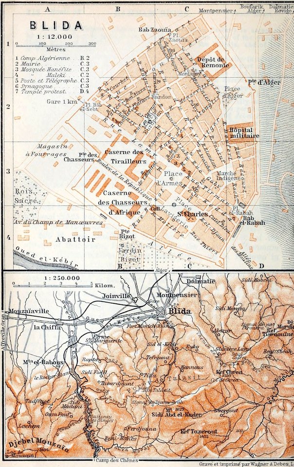
230 M. Blida.—The Station (689 ft.) lies about ¾ M. below the town, to the N.W., 18–20 min. from the chief hotels. Omnibus to the Place d’Armes, with luggage, 10 (at night 20) c.; cab 50 c.
Hotels. Hôt. d’Orient (Pl. a; C, 3), Rue d’Alger and Place d’Armes, R. 3–5, B. 1–12, déj. 3½, D. 4, pens. 12, omn. ½ fr. good; Hôt. Géronde (Pl. b; B, 2), Rue Lamy, plainer; Hôt. de la Mitidja (Pl. c; B, 2), Rue Flatters, corner of Rue Pélissier, R. 2, déj. or D. 2 fr., plain but good; Hôt. de la Gare, near the station, déj. 1½, D. 2 fr., humble.—Café d’Orient, in the hotel, and Brasserie Lyonnaise, both in the Place d’Armes.
Post & Telegraph Office (Pl. 5; C, 3), Place d’Armes.
Cabs (stand in the Rue de l’Hôpital, behind the Place d’Armes). In town ½, to Sid-el-Kébir 3–5, Chiffa Ravine 8–12 fr. (according to bargain).
Sights. Forenoon, Jardin Bizot, Bois Sacré, cemetery of Sid-el-Kébir, and Stud Farm (‘la Remonte’); afternoon, trip to the Chiffa Ravine, either from Sidi-Madani or Camp-des-Chênes (p. 215). If desired Algiers may be reached by train the same evening. The attractive mountain tours (Les Glacières, etc.) are feasible in summer only.
Blida (886 ft.; pop. 18,400, incl. 10,700 Mohammedans), one of the pleasantest provincial towns in Algeria, with a strong garrison, is charmingly situated at the N. base of the Tell Atlas, on the right bank of the Oued el-Kébir. To this so-called ‘great river’, as well as to the considerable rainfall in winter, the town is indebted for the splendid timber in its public grounds and the luxuriant vegetation of its orchards, notably the orange-groves between the N. suburbs of Joinville and Montpensier. The town is said to have been founded by Andalusian Moors in 1535; in 1825 it was destroyed by an earthquake; it has been rebuilt since 1838, but in 1867 was again much damaged by an earthquake.
214From the station we proceed viâ the Avenue de la Gare to the Bab el-Sebt (Pl. A, B, 2), 5 min. to the N.E. of the Bois Sacré (see below), and within the town-walls we follow the Rue Lamy, called also Boulevard Trumelet, to the—
Place d’Armes (Pl. C, 3), which, with the adjoining Rue d’Alger (Pl. C, 3, 2), is the centre of traffic. This pleasant square is planted with plane-trees and has a fountain in the centre shaded by a great date-palm (a band plays here in winter). Adjacent is the Place Lavigerie with the Catholic church of St. Charles (Pl. C, 4).
The streets to the N. of the Place d’Armes, with the two small Mosques (Pl. 3 & 4; C, 3, 2), and the lanes near the Place du Marché-Indigène (Pl. C, D, 3; interesting Friday market) are inhabited mainly by Mohammedans and Jews. From the Place d’Alger, at the end of the Rue d’Alger, the Rue Zaouïa leads to the left to the large Stud Farm (Dépôt de Remonte; Pl. C, 1), where fine horses of the Arab and Barb breeds may be seen.
From the Place d’Armes the Rue and Porte Bizot lead to the S.W. to the *Jardin Bizot (Pl. B, 4), containing fine araucarias, palms, and magnolias. On the N. side of the Avenue du Champ-de-Manœuvres, 5 min. to the W. of the Porte Bizot, lies the famous Bois Sacré (Pl. A, 3, 4), where two picturesque tombs of saints are shaded by superb groups of Aleppo pines, araucarias, and olive-trees.
The Avenue du Champ-de-Manœuvres joins, near the drill-ground, the highroad to Boukirka (and Affreville; comp. p. 212), from which, just before Chiffa (p. 213), 5 M. to the W. of Blida, the road to the Chiffa Ravine and Médéa (p. 215) diverges to the left. This route to the Rocher Blanc (p. 215) is uninteresting and in summer extremely dusty (cabs, see p. 213).
From Porte Bizot we may turn to the E. and walk round the town-walls through an avenue of carob-trees to the Bab el-Rabah (Pl. D, 4), the S.E. town-gate, which is reached also from the Place d’Armes by the busy Rue Tirman. To the S. of this gate the Avenue des Moulins, a broad avenue of planes, leads along a conduit with several mills into the pretty valley of the Oued el-Kébir. After 10 min. we diverge to the right by a shadeless road, passing pleasant orange-groves and crossing the stream twice, and then, just beyond (½ hr.) a mill, ascend a path to the left to the poor village of Sid-el-Kébir. Above the village are the Zaouïa and the picturesque Cemetery of Sid-el-Kébir, with the tombs of Ahmed el-Kebîr (d. 1560), the founder of Blida, and his two sons, to which on great Mohammedan festivals pilgrims flock from far and near. A second footpath to the N. descends hence into the valley.
The highest mountains of Blida, the Jebel Mouzaïa (p. 213) and the *Pic des Beni-Salah or Jebel Sidi Abd el-Kâder (5345 ft.), are famed for their cedar-forests, where the natives, however, have made sad havoc, and for the grand panorama they command. The distant view embraces the Tell Atlas from the Ouarsenis (p. 209) to Jebel Dira (p. 250), the Dahra (p. 208), and the whole of the 215Mitidja with the Sahel and the Jurjura chain (p. 258). The ascent of the Jebel Sidi Abd el-Kâder viâ Aïn-Talazit takes 4 hrs.—Hardly less repaying is the ascent of the Kef Chrea (5085 ft.), to the S.E. of Blida, to which a bridle-path (mule 4–5 fr.) leads from the Avenue des Moulins (p. 214), viâ the village of Les Glacières (3957 ft.; Hôt. d’Altitude, déj. 3 fr., good) in 4 hrs.
From Blida to Berrouaghia, 52 M., railway in 4 hrs. (fares 9 fr. 40, 6 fr. 70, 5 fr. 5 c.). The train diverges to the S.W. from the Oran and Algiers line, crosses the Oued el-Kébir and the Chiffa (p. 213), and beyond the Rocher Blanc (466 ft.; inn) enters the Gorges de la Chiffa, a grand defile, flanked with the slopes of the Pic des Beni-Salah and Jebel Mouzaïa, here over 3000 ft. high. At (7½ M.) Sidi-Madani (597 ft.) begins the finest part of the ravine; the grandest scenery is around the Hôt. du Ruisseau-des-Singes (738 ft.; déj. 1¾–3, D. 3 fr.), at the mouth of the side-valley of the Oued Tamesguida, and at the waterfalls beyond the inn. The numerous apes (p. 171) that dwell in the rocks here sometimes descend to the bottom of the valley.—12 M. Camp-des-Chênes (1253 ft.; inn), beyond the lateral valley of the Oued Merdja. Following the valley of the Oued Mouzaïa the train leads round the S. slope of Jebel Mouzaïa to (19½ M.) Mouzaïa-les-Mines (1640 ft.), with its deserted copper and iron mines, and then, in numerous windings, ascends the W. slope of Jebel Nador (3675 ft.; fine views) to (28 M.) Lodi (3042 ft.).—31 M. Médéa (3019 ft.; Hôt. d’Orient; Hôt. du Commerce; pop. 3800, incl. 1900 Mohammedans and 1200 Jews), a small town, perhaps on the site of the Roman Lambdia (Tirinadis?), was founded by Bologgîn ez-Ziri (comp. p. 221), and was the capital of a beylic in the Turkish period under the name of Titteri. Great native markets (Thurs. and Frid.). The environs yield excellent white wine, but it is often adulterated.—The train next ascends to the S.E., in numerous windings, to (44½ M.) Ben-Chicao (3790 ft.), the highest station on the line.—52½ M. Berrouaghia (2953 ft.; Hôt. de France; Hôt. des Voyageurs), a small town of 2300 inhab., is the present terminus of the line, which is being continued to Djelfa.
A diligence runs daily in 5½ hrs. (at 1 p.m., returning at 9.35 a.m.) to (27½ M.) Boghari (2077 ft.; Hôt. Célestin, R. 2, déj. or D. 2½ fr.), a small trading town of some importance on the upper Chélif (p. 208), with a Monday market and a picturesque Ksar on a hill (evening dances by girls of the Ouled Naïl tribe; see below).
Boghari is the starting-point of the important caravan-route to the Sahara oases of Laghouat and Ghardaïa. Diligence every other day at 3 a.m. vîa Aïn-Oussara and Djelfa (night-station) to Laghouat in 58 hrs. (also motor-omnibus sometimes); most of the stopping-places have very fair inns or caravanserais (R. usually 2, déj. or D. 2½ fr.). 13 M. Boughzoul or Bou-Guezoul (2100 ft.); 32½ M. Aïn-Oussara (2330 ft.); 57 M. Guelt es-Stel (all three in the Hauts-Plateaux, p. 169); 85 M. Zmila (good drinking-water); 96 M. Djelfa (3803 ft.; Hôt. de France, quite good; Hôt. du Roulage; pop. 2200), in the midst of the Sahara Atlas. This little town, situated in the valley of the Oued Djelfa or Melah, where dolmens abound, and at the junction of our road with the caravan-route to Bou-Saâda (p. 270), is the capital of the nomad tribe of the Ouled Naïl, whose daughters usually lead an evil life in the S. Algerian towns before marriage. (Their valuable trinkets are noticeable.) 118 M. Aïn-el-Ibel (3412 ft.); 137 M. Sidi-Maklouf (3019 ft.).—177½ M. Laghouat (2461 ft.; Hôt. Storace, good; Hôt. Mendane; pop. 5700, incl 5000 Mohammedans and 400 Jews). This picturesque little town, on the S. slope of the Sahara Atlas, with its military headquarters and brisk trade, lies on the Oued Mzi (called Oued Djedi lower down; p. 284), amidst the fruit-trees of a palm-oasis. It has a pretty Jardin Public. The native quarters present a curious and lively scene.
The journey from Laghouat to (130½ M.) Ghardaïa by the rough 216Sahara road is very fatiguing. (Diligence every second day, in winter at 4 a.m., in summer at 5 p.m., in 30 hrs.; fare 30 or 25 fr.; motor-omnibus projected.) The chief stages are: 220½ M. (from Boghari) Tilghemt or Tilrempt (quarters), in an oasis of terebinths (p. 202); 265 M. Berrian (1936 ft.), a little town of 3800 inhab., the northmost settlement of the Mozabites (17th cent.), lying on the chalky limestone plateau of the Chebka, with a palm-oasis on the Oued Bir.
308 M. (from Boghari; 130½ from Laghouat) Ghardaïa (1805 ft.; Hôt. du Sud; pop. 8200, incl. 5400 Mozabites), a free market, is one of the most picturesque and interesting places in the Sahara. Situated on the Oued Mzab, in a beautiful oasis, with 64,000 palms, the town is enclosed by a lofty wall defended with towers, and is dominated by the great minaret of the chief mosque. It holds high market on Fridays, and has two places of amusement (for Arabian music and dances). Ghardaïa is the headquarters of the Mzab, a small republic of towns which was founded in the 11th cent. by fugitive Berber Ibadites (p. 208) after the destruction of Tiaret, was presided over by a priestly caste (tholbas), and in 1852 became a protectorate of the French who annexed it in 1882. The Mozabites or Mzabites, who hold aloof from the other Mohammedans, are often met with as artisans and small traders in the towns of the Tell Atlas and in the oases of the E. Sahara, but in their old age they always return to their original home. Their manners and customs are still somewhat mediæval; their mosques with minarets in the form of blunted pyramids, their curious cemeteries and tombs with votive offerings, and their schools will be found interesting. Their language is a Berber dialect akin to those of the Kabyles (p. 252) and the Tuâreg, but Arabic and French also are generally spoken.
Among places worth seeing near Ghardaïa are (¾ M.) Mélika, with its black inhabitants and large cemeteries, and (1¼ M.) Beni-Isguen, a wealthy place of 5400 inhab., the sacred town of the Mozabite league, from which Arabs and Jews are excluded, with a massive town-wall, clean streets (smoking forbidden), and a loftily situated castle. The oldest town of the league is El-Ateuf, founded in 1012, with 2000 inhab., 5½ M. to the E. of Ghardaïa, on the caravan-route to (55½ M.) the Mozabite colony of Guerrara. Other caravan-routes lead from Ghardaïa to the S.W. viâ (166 M.) El-Goléa (1280 ft.), with its small oasis, to In Salah and the Tuat Oases, and to the S.E. to (112 M.) Ouargla (p. 285).
Beyond Blida the train, running to the N.E., through orange-groves and fields of vegetables, again descends to the Mitidja. 234 M. Beni-Mered (459 ft.), with fertile gardens.
239 M. Boufarik (164 ft.; Hôt. Benoît, Boul. National; Hôt. Nemoz, Place Mazagran, D. 2 fr., quite good; Hôt. de la Gare, humble; omn. to the Place Mazagran; pop. 6000), once a fever-stricken village of peasants, is now the centre of trade for the produce of the Mitidja. Around it are admirably irrigated vineyards and orchards (oranges, mandarins, etc.), sheltered from the prevailing winds by planes, thujas (arbor vitæ), or cypresses. Near it are factories of perfume and immense wine-cellars. To the W. of the town is the large Marché Arabe (cattle-market; Monday), 12 min. from the Place Mazagran, or reached by a road direct from the station.
On the right, farther on, we observe the hill-ranges of Rovigo and L’Arba (pp. 248, 247) and the Jebel Bou-Zegza (p. 249). Beyond (245½ M.) Birtouta-Chebli we near the low spurs of the Sahel (p. 221). 252½ M. Gué-de-Constantine, in the plain of the brook Harrach (p. 247), where the eucalyptus abounds.
217254½ M. Maison-Carrée (p. 247), junction of the lines to Tizi-Ouzou (R. 38), Bougie (R. 37), Constantine (R. 43), and Biskra (R. 44), and also of the tramways to Aïn-Taya and Rovigo (p. 219).
The train turns to the N.W. and reaches the shore. High up on the left lies Kouba (p. 233). 257½ M. Hussein-Dey, see p. 233.
Skirting the Jardin d’Essai, on the left (p. 232), we now sight Algiers. Beyond the S.E. suburbs of Le Hamma, Belcourt, and Mustapha-Inférieur (p. 232), we come to the minor station of (260½ M.) Agha and then to the (262½ M.) main station of Algiers.
34. Algiers.
Arrival by Sea. The French steamboat lines (RR. 20, 22) have their own piers. The fare for landing by boat from other steamers is 30 c. (trunk 20 c.; small articles free). The tariff of the porters (portefaix-commissionnaires, largely natives, mostly exorbitant) to the lower part of the old town is 25 c. for a trunk of 25 kilos (55 lbs.), 50 c. up to 50 kilos, and 1 fr. up to 100 kilos; for porterage to the custom-house (Douane; where baggage is not cleared on Sun. or festivals) 25–50 c., according to bargain. The numbered porters of the steamboat companies had better be employed; or the matter may be entrusted to the hotel-agents. The services of guides, interpreters, and the like should be declined.
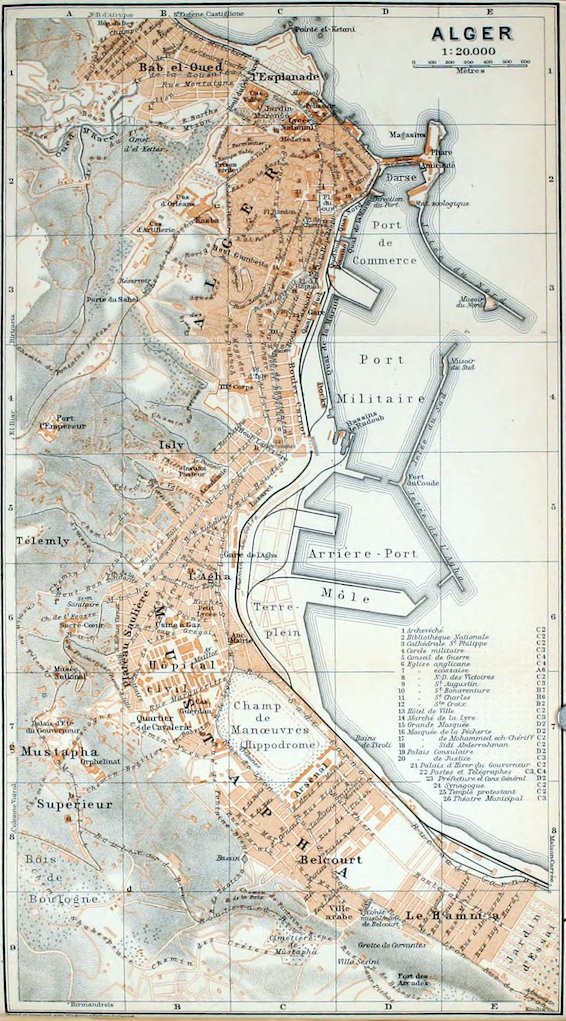
Railway Stations. 1. Chief Station (Gare; Pl. C, 3), Quai Sud, below the Rampes Magenta (p. 223) and Boul. Carnot, 5–15 min. from the hotels in the town, ¾–1 hr. from those at Mustapha-Supérieur: station for all the hotel-omnibuses (no tramway; cabs, see p. 218).—2. Gare de l’Agha (Pl. C, 5, 6; also goods-station), Rue Sadi-Carnot, at Agha-Inférieur (p. 232), a subordinate station for the S. quarters of the town.—Town-offices of the railways, Boul. Carnot 2 and at the Agence Lubin (p. 219).
Hotels (comp. p. 174; in Feb. and March rooms should be ordered in advance). In the Villa Quarter (Mustapha-Supérieur and Quartier d’lsly; mostly closed in summer), suitable for some stay, clientèle largely English and American: *Hôt. Continental (Pl. c; A, 6), Chemin du Télemly and Boul. Bon-Accueil (entered also from the Station Sanitaire, p. 228), on a high site, with fine views and garden, R. 5–20, B. 1½, déj. 4–5, D. 6–8, pens. from 13, omn. 3 fr.; *Hôt. St. George (Pl. a; A, 8), Rue Michelet, with beautiful grounds, R. 5–15, B. 1½, déj. 4–4½, D. 6–7, pens. 13–25, omn. 3 fr.; Alexandra (Hôt. Kirsch; Pl. b, A 8), same street, with garden and small terrace, R. 4–18, B. 2, déj. 3½–4½, D. 5–6, pens. 12–25, omn. 3 fr., good cuisine; these three are of the first class.—Hôt. Oriental (Pl. f; A, 6), Boul. Bon-Accueil (entrance from Station Sanitaire), with garden, R. 5–10, B. 1¼, déj. 3, D. 4, pens. from 9 fr., good cuisine; Grand-Hôtel (Pl. g; A, 7), above Rue Michelet, with fine grounds, pens. 9–12 fr.; Hôt. Beau-séjour (Pl. e; A, 6), Rue Michelet, below the Museum Terrace (p. 228), R. 3–8, B. 1, déj. or D. 3, pens. 8–10, omn. 2½ fr., open throughout the year; Pens. Villa Olivage, beyond the Bois de Boulogne (p. 230), good; Pens. Victoria, Rue Michelet, near the Colonne Voirol.
In the Town, nearer the sights, more convenient for excursions: *Hôt. Excelsior (Pl. h; C, 4, 5), Boul. Laferrière, 8 min. from the Gare de l’Agha, well fitted up, with restaurant, R. 1–30, B. 1¼, déj. 3½, D. 5, board 8, omn. (also from the Agha station) 1 fr.; *Hôt. de l’Oasis (Pl. k; C, 3), Rue du Laurier 2 and Boul. de la République 9, with fine views, restaurant, and American bar, R. 3–18, B. 1½, pens. from 10, omn. 1¼ fr.; Hôt. de la Regence (Pl. 1; C, 2), Place du Gouvernement 3, R. 4–10, B. 1½, déj. 3½, D. 4½, pens. 12–20, omn. 1½ fr.; Gr.-Hôt. Arago & du Palmier 218(Pl. m; C, 3), Rue Arago 6, quiet; Hôt. de Nice (Pl. n; C, 8), Rue Garibaldi 2 and Place de la République (Square Bresson).
Hôtels Garnis. Hôt. des Etrangers (Pl. i; C, 3), Rue Dumont-d’Urville 1, near the Place de la République, R. 3½–7½, B. 1½, Hôt. d’Europe & Terminus (Pl. o; C, 3), Rue Garibaldi, corner of Boul. Carnot (R. 3–7, B. 1 fr.), Royal Hotel (Pl. p; C, 3), Boul. de la République 10 (R. from 2½ fr.), both with fine views; Hôt. Regina, Boul. Bugeaud.
Cafés. Café Continental (Brasserie Maxéville), Café d’Alger (Brass. de Tantonville), both Place de la République; Café de Bordeaux, Boul. de la République 1, corner of Place du Gouvernement; Café d’Apollon, Place du Gouvernement 4.—Confectioner. Maison Fille, Rue Bab-Azoun 2.
Restaurants. At the Hôtel Excelsior (p. 217); London House, at the Hôt. de l’Oasis, Boul. de la République 9, déj. 3, D. 4 fr.; *Taverne Gruber, same boulevard, No. 7, a favourite resort (music in the afternoon and evening); Jaumon, Rue Dumont-d’Urville, déj. 2, D. 2½ fr., plain but good.—For Luncheon (fish, sea-crayfish, shell-fish, etc.): *Restaur. Cassar and Restaur. de la Pêcherie, Rampe de la Pêcherie.—Beer at the *Brasserie Terminus, Boul. Carnot 1 (in Hôt. de l’Europe), D. 3 fr.; also, Rue de la Liberté 6, Brass. de l’Etoile (music in the afternoon and evening) No. 11, Brass. Suisse; No. 8, Brass. du Phénix; No. 1, Brass. Lorraine.
Cabs (voitures de place).
‘Double courses’ (there and back):— per hr.
a) within the First Zone, extending as far as the European cemetery of St. Eugène (beyond Pl. B, 1) to the N. and as the beginning of the Champ de Manœuvres (Pl. C, 7) to the S. 1.50 2.—
Each ¼ hr. —.50
b) within the Second Zone, including the W. margin of the town (Prison Civile, Télemly, Palais d’Eté at Mustapha, etc.) and extending as far as Deux-Moulins beyond St. Eugène (comp. Map, at p. 233) to the N. and the Cimetière Musulman (Pl. D, 9) at 2.— 2.—
Belcourt to the S. To the Jardin d’Essai (and back) 2.50
Each ¼ hr. —.75
Within the Third Zone comprising the regions beyond those just named:
Half-day (6 hrs.), within a radius of 15 kilometers (9½ M.) 11.—
Whole day (12 hrs.), within a radius of 25 kilomètres (15½ M.) 20.—
During the night-hours (12–6 a.m.) a fare and a half is charged.—For waiting, ½ fr. extra for each ¼ hr.—Hand-luggage up to 20 kilos (44 lbs.) free; each piece exceeding that 50 c.
Motor Cabs (Automobiles de place; stand, Rue Garibaldi). Drive under 900 mètres (984 yds.) 1 fr. 50 c.; for each addit. 300 m. 20 c.; small articles free; trunk 50 c.
Carriages (cabs and ‘voitures de grande remise’; fares raised on Sun. and holidays). Vitoz & Co., Rue Michelet 105, Mustapha-Supérieur; Sanino, Rue de Strasbourg 3, and Rue Michelet 117; Comp. Générale des Voitures, Rue de Strasbourg 7.—Saddle Horses let by Vitoz and Sanino.—
Motor Cars for excursions: Metrot, Marcé, both Rue d’Isly 39; Anglo-American Garage, Chemin du Télemly; E. Paul, Rue d’Isly 73.
Tramways (1st and 2nd cl.). 1 (without name-board). From Hôpital du Dey (Pl. A, B, 1) to Rue Bab el-Oued (Pl. C, 1, 2), Place du Gouvernement (Pl. C, 2), Rue Bab-Azoun (Pl. C, 2, 3), Rue d’Isly (Pl. C, 3, 4), Rue Michelet, and Station Sanitaire (Pl. A, 6), every 5 min. (but 5–6 a.m. and 10–12 p.m. every 10 min. only); fare 5–20 c.—2 (red name-board). From Place du Gouvernement to Rue d’Isly, Rue Michelet, and Colonne 219Voirol (comp. Pl. A, 8), every ½ hr. (from 6 a.m., last car at 8.5 p.m.), in 40 min.; fare 30 or 20 c.—3 (blue). From Place du Gouvernement to Rue d’Isly, Rue Michelet, and Boul. Bru (Pl. A-C, 8, 9), every ½ hr. (last car 7.50), in ½ hr.; 30 or 20 c.—4 (green). From Place du Gouvernement to Boul. Carnot (Pl. C, 3), Rue de Constantine (Pl. C, 4), Rue Sadi-Carnot (Pl. B, 5, 6), Rue de Lyon (Pl. B-E, 7–9), Le Ruisseau, and Kouba; as far as Marabout (Cimetière Musulman de Belcourt) every 5 min.; to Les Platanes (Jardin d’Essai) every 10 min.; to Kouba every 40 min.; fare 35 or 30 c.—5 (red). From Place du Gouvernement to Boul. Carnot, Rue Sadi-Carnot, Jardin d’Essai (Oasis des Palmiers, in 27 min.), Nouvel Ambert, Maison-Carrée (in 1 hr.); as far as Nouvel Ambert every 10 min., to Maison-Carrée every 20 min.; fare 60 or 45 c.—6. From Place du Gouvernement to Rue de la Lyre (Pl. C, 2, 3), Rue Rovigo (Pl. C, 3), Prison Civile (Pl. B, C, 2; 20 or 15 c.), El-Biar (comp. Pl. A, 4; 40 or 35 c.), and Château-Neuf (in 50 min.; 50 or 40 c.); as far as Prison Civile every ¼ hr., to El-Biar every ½ hr., to Château-Neuf once every hr. (Sun. every ½ hr.).—7. From Place du Gouvernement to Boul. de France (Pl. D, 2), Esplanade (Pl. C, 1), Bab el-Oued (Pl. B, 1), St. Eugène (comp. Pl. B, 1), and Deux Moulins, every 9 min.; 30 or 20 c.
Steam Tramways from the Place du Gouvernement: to (7½ M.) Maison-Carrée (p. 247), and thence either to (4½ M.) Fort-de-l’Eau (p. 248) and (12½ M.) Aïn-Taya (p. 248), or to (10½ M.) L’Arba (p. 247) and (15½ M.) Rovigo (p. 248); to (22 M.) Mazafran (p. 238), and thence either to (6¼ M.) Koléa (p. 238), or to (6½ M.) Castiglione (p. 238).
Post & Telegraph Office (Pl. 22, C4; p. 226), Rue de Constantine 133; branches at Rue de Strasbourg 2, in the Palais Consulaire (p. 223), at Rue Michelet 64 (Mustapha-Inférieur), near the Palais d’Eté (p. 230), etc.
Steamboat Agents. Cunard, North German Lloyd (R. 15b), Hamburg-American, German Levant (RR. 15b. 22), and Hungarian Adria (R. 22). R. Heckmann, Rue Colbert 1; Comp. Générale Transatlantique (RR. 20, 22), Boul. Carnot 6 and Quai de la Marine; Soc. de Transports Maritimes (R. 20), Boul. de la République 2 and Quai de la Marine; Comp. de Navigation Mixte (R. 20), Boul. Carnot 2 and Quai do la Marine; White Star Line, Austro-American Line, J. Crispo, Boul. de la République 3; Nederland Royal Mail, J. Bergeret, Boul. Carnot; Compañía Mallorquina de Vapores (R. 20), J. J. Sitges Frères, Quai Nord 40.
Tourist Agents. R. Heckmann (Universal Tourist Office), Boul. de la République 11; Agence Lubin, Rue de la Liberté 7; Agence Duchemin, same street, No. 4.—Information obtainable also from the Comité d’Hivernage, Rue Combe 2. 8–11 and 2–6 (Sun. 8–11).—Club Alpin Français (section de l’Atlas), Palais Consulaire (p. 223).
Consuls. British Consul-General, B. S. Cave, Boul. Carnot 6; vice-consuls, L. G. C. Graham, L. Graeme Scott.—U. S. Consul, A. W. Robert, Rue d’Isly 64.
Physicians. Dr. Dangerfield, Kent House, Colonne Voirol; Dr. Gubb, Mustapha, Chemin des Glycines; Dr. Nissen, Mustapha-Supérieur, Villa Bey, Rue Michelet.—Chemists. Grandmont (Obrecht), Rue Bab-Azoun 28; Licht, Rue Michelet 85; Brenta, Rue Bab-Azoun 3.
Baths. Bains du Palmier, Rue Arago 6 (Gr.-Hôt. Arago & du Palmier); Bains du Hamma, Rue du Hamma 1 (near the Théâtre Municipal); Bains Michelet, Rue de Richelieu 25.—Moorish Baths (comp. p. 175): Bains de l’Alhambra, Rue Marengo 4.—Sea Baths (June-Oct.; plainly fitted up; costume 50 c.): Bains du Jardin d’Essai (p. 233); Bains Nelson, Avenue Malakoff.
Banks (comp. p. 174). Crédit Lyonnais, Boul. de la République 6; Comp. Algérienne, Rue Dumont-d’Urville; Banque de l’Algérie, Crédit Foncier et Agricole d’Algérie, Crédit Agricole et Commerciel Algérien (J. Thibaud), all three in the Boul. de la République (Nos. 5, 8, & 4).
220Booksellers. Jourdan, Place du Gouvernement and Rue Cléopâtre 1; Chaix, Rue d’Isly 11bis; Relin, Rue d’Isly 11; Ruff, Rue Bab-Azoun 10; Carbonnel, Ledoux, both Boul. de la République (Nos. 2 & 7).—Newspapers (5 c.). La Dépêche Algérienne (morning); Les Nouvelles, Le Cri d’Alger (evening). For strangers, The North African News (Sat.; 25 c.).
Shops (caution almost as necessary as at Tunis; comp. p. 331). Photographs and Views. Geiser, Place de Chartres 2; A. Wollenweider, Rue du Divan 4; Hyam, Station Sanitaire (Pl. A, 6).—Oriental Articles (partly made in France and Germany; also Indian, Japanese, and Turkish wares). Ratto (goldsmith), Rue Socgémah 12; Pohoomull Frères, Rue Bab-Azoun 11; Ratto-Magana, Rue de l’Etat Major 5; Miss Jockyl, English Club Buildings, Mustapha-Supérieur.—Embroidery. Mme. Hémery, Rue Michelet 89, Mustapha-Supérieur.—Copper and Brass Work. Zagha (from Damascus), Rue Bruce 27; Nassan, Place Malakoff.
Theatres. Théâtre Municipal (Pl. 26; C, 3), Place de la République, for operas, operettas, and dramas, closed in summer; Kursaal (Pl. C, 1), Esplanade de Bab-el-Oued (tickets sold in advance at 4 Boul. de la République.—Casino Music Hall), Rue d’Isly 9 (fauteuil 2½ fr.).—Fêtes Mauresques at the Kasba, arranged by the Comité d’Hivernage (p. 219), with native musicians and dancers (adm. 5 fr.).
Band plays in winter, Sun. and Thurs., 4–5, in the Place du Gouvernement; in summer (May-Oct.), on Mon., Wed., and Sat., from 8 to 10.30, in the Place de la République (Square Bresson), and on Sun., Tues., and Thurs., from 8 to 10.30, in the Place du Gouvernement.
Golf Club, with good nine hole course, near the Pens. Villa Olivage (p. 217).—Skating Rink at the corner of Boul. Carnot and Rue Waïsse (Pl. C, 4).
Churches. English (Ch. of the Holy Ghost; p. 230), Rue Michelet (Pl. A, 7), to the N. of the Alexandra Hotel (p. 217); Sun. services at 8 and 11.30 or 9.45 a.m.; chaplain, Rev. A. P. Cronyn, M. A.—Presbyterian (St. Andrew’s; Pl. 7, A 6) also Rue Michelet, Sun. service at 10.30 a.m.; minister, Rev. T. E. Jubb, M. A.
Sights, with days and hours of admission:—
Archevêché (p. 224), all day; fee ½–1 fr.
Bibliothèque Nationale (p. 225), week-days 1–6; closed Aug. and Sept.
Conseil Général (p. 224), apply to secretary; week-days 8–11 and 1–5.
Jardin d’Essai (p. 232), all day (Zoologie 50 c.).
Kasba Barracks (p. 227), apply to Etat-Major, Rue de la Marine 11.
Medersa (p. 228), except during lectures; closed Sun., Frid., and on great Mohammedan festivals.
Mosquée de la Pêcherie (p. 223), at any time except during prayers.
Mosque, Great (p. 224), as above.
Mosque of Sidi Abderrahmân (p. 228), Sun., Mon., Tues., 8–12 and 2–3; closed on the chief Mohammedan holidays.
Musée Municipal des Beaux-Arts (p. 226), daily, except Friday.
Museum (p. 229), daily, except Mon., 1–4 (1st April to 15th July 2–5; closed 16th July to 30th Sept.).
Palais d’Eté du Gouverneur (p. 230), in his absence; fee ½–1 fr.
Palais d’Hiver du Gouverneur (p. 225), as above.
Synagogue (p. 227), all Frid., Sat. after 12, at other times apply to keeper, 30–50 c.
As to visiting the Mosques, see p. 174.—Men are not admitted to the Mohammedan Cemeteries (p. xxvi) on Frid. and holidays 12–6.
Two Days. 1st. Forenoon, Place de la République, Boul. de la République, Place du Gouvernement, Great Mosque, Archevêché (pp. 222–224), *Kasba Quarter (pp. 226, 227), *Mosque of Sidi-Abderrahmân (p. 228), and *Jardin Marengo (p. 224). Afternoon, Mustapha-Supérieur with the *Museum (pp. 228–230).—2nd. Forenoon, Mohammedan Cemetery at Belcourt (p. 232), *Jardin d’Essai (p. 232). Afternoon, Notre-Dame d’Afrique (p. 236) or Bouzaréah (p. 235).
221Algiers, French Alger, Ital. Algéri, the capital of the French colony of Algeria, with 154,000 inhab. (incl. 35,200 foreigners, mostly Italians and Spaniards, 33,200 Mohammedans, and 12,500 Jews), seat of the archbishop of Algeria, a fortress, and a naval harbour, lies in 36°47′ N. lat. and 3°2′ E. long., on the W. side of the nearly semicircular *Baie d’Alger, which is bounded on the W. by the Pointe Pescade (p. 237), and on the E. by Cape Matifou (p. 248). It is the most important coaling-station on the whole coast, and shares with Oran the chief trade of Algeria. The town extends along the slopes of the Sahel of Algiers, a range of hills about 44 M. long, culminating in Mt. Bouzaréah (p. 235), continued beyond the mouth of the Oued el-Harrach by low sand-hills, and separated from the Tell Atlas by the Mitidja (p. 169). With regard to climate, see pp. 170, 172.
On the site of the Roman Icosium, an unimportant place on the road to Tipasa and Cæsarea (Cherchell, p. 244), Bologgîn ez-Ziri (p. 323), about 940 (about the same date as the foundation of Miliana and Médéa) founded the new colony of Al-Jezaïr Beni Mezghanna, so called from the adjacent coast-islands (jezîra, pl. jezaïr) and from the Berber tribe of the Beni Mezghanna who dwelt in this region. It is recorded that in the 11th cent. the inhabitants of the new settlement used the old Roman baths, of which there is now no trace, for their amusements and an old Christian basilica for their worship. From that time the history of Al-Jezaïr is a blank down to the end of the 15th cent., when it began to serve the Moorish exiles from Spain (afterwards called Tagarins here) as a base of their retaliatory expeditions against Spain. In 1509 or 1510 the Spaniards, in the course of their victorious career, occupied the largest of the coast-islands, where they erected the fortress of El-Peñón, and conquered the Mitidja which had recently been colonized by the Arabian tribe of the Tsaliba. The little town, called Argel by the Spaniards, was inhabited by Mohammedans, who in 1516 summoned to their aid, from Djidjelli, Horuk (Arudj) Barbarossa, a Turkish pirate of Christian descent. Horuk complied with the request and established himself at Al-Jezaïr, where, after repelling a Spanish expedition under Diego de Vera (1516), he erected the Jenina as his residence and the Kasba as his citadel.
Having fallen in a battle with the Spaniards near Tlemcen (p. 187), Horuk was succeeded by his brother Kheireddin Barbarossa (1518–36), who became the real founder of the new barbaresco or piratical state. As a vassal of the sultan of Turkey he extended his sway over the greater part of Algeria. He defeated Hugo de Moncada, the Spanish viceroy, in 1519, and in 1530, after having stormed the fortress of Peñón, he constructed the Jetée de Kheireddin with its materials and with others from Rusguniæ (p. 248) and Tipasa, thus creating the first harbour of Algiers. Thenceforwards for three centuries the ‘Algerian pirates’ were the terror of the seas, to whom, for protection of their trade, England, Holland, the Hanseatic towns, and other maritime countries ignominiously consented to pay tribute. Fourteen times the European powers, from the time of the fruitless campaign of Charles V. in 1541 to the British expedition of 1824, had besieged and bombarded Algiers in vain. The beys (or, after 1600, deys) had succeeded in maintaining their position, and in 1627 had even carried their piratical expeditions as far as Iceland. It was not till 1830 that these barbarous piracies were put a stop to by the French, and that the way was thus paved for conquest of the whole of Algeria.
The most stirring events in the recent history of Algeria were the conquest of Constantine (1837), the protracted struggles against Abd el-Kâder (1839–47), the defeat of his Moroccan allies on the Oued Isly (1844), 222the subjection of Great Kabylia (1856–7), the revolts of the natives in 1871–2, the rising of Bou-Amama in S. Oran (1881), the occupation of the Sahara as far as Tidikelt and the Tuat oases (1892–1901), and lastly the French advance towards Morocco (comp. p. 96).
The Algiers of the Turkish period consisted solely of the triangular quarter on the slope of the Kasba Hill, between the old landward gates, Bab Azoun on the S. and Bab el-Oued on the N., with the Sûk or Market Street (now Rue Bab-Azoun and Rue Bab el-Oued) as its nucleus. Between these two gates ran the old Turkish wall, on whose site lie the Boul. Gambetta (Pl. B, C, 3), on the S., and the Boul. Valée (Pl. C, 2), on the N. The French ramparts constructed in 1845 extended the town as far as the present Boul. Laferrière (Pl. C, 4, 5) to the S., and to the Boul. du Général Farre to the N. (Pl. C, 1). Since the demolition of these fortifications in 1904 the industrial suburbs on the coast and the lofty villa-suburbs, Quartier d’Isly (Pl. B, 4, 5), Télemly (Pl. A, 5, 6), and Mustapha-Supérieur (Pl. A, 7, 8), which last is little frequented except in winter, have all been brought within the precincts of the town.
a. Lower Quarter of the Old Town.
The chief business parts of the town are the arcades, with their numerous shops, in the Rue Bab-Azoun (Pl. C, 2, 3) and Rue Bab el-Oued (Pl. C, 2; p. 224), the Place du Gouvernement (Pl. C, 2; p. 223), the focus of all the tramways, and above all the spacious Place de la République (Pl. C, 3), with the gardens of Square Bresson (band, see p. 220), adorned with bamboos and magnolias, the Théâtre Municipal (p. 220), and the most showy cafés. Between these two places and the sea, at a height of 65 ft. above the quay and its warehouses, run the uniform rows of houses of the Boulevard de France (Pl. D, 2; p. 223), the Boulevard de la République, completed in 1866, and the Boulevard Carnot (Pl. C, 3, 4), with the new Préfecture (Pl. 23; C, 4) in the Moorish style (1910). These streets, together 1 M. long, form a coast-promenade, whence in clear weather we enjoy a splendid *View of the blue bay, the Atlas Mts. of Blida, and the distant Jurjura chain (p. 258). In stormy weather, however, the Rampe de l’Amirauté (Pl. D, 2; p. 223) and the Boul. Amiral Pierre (Pl. C, D, 1, 2; p. 224) attract many walkers.
The sole Harbour, prior to the French period, was the Ancien Port, or Darse de l’Amirauté (Pl. D, 2), constructed by Kheireddin Barbarossa, once a nest of piratical vessels, and now a torpedo-boat station and anchorage for yachts and fishing-boats. The new Port de Commerce and Port Militaire, 213 acres in area, with the Quai de la Marine, which was extended in 1908, have been formed since 1848 at a cost of 46 million francs. They are protected by the wave-beaten Jetée du Nord, 984 yds. long, the prolongation of the old Jetée of Kheireddin (comp. p. 221), and by the Jetée du 223Sud, 1350 yds. in length. The entrance is 268 yds. in breadth. A second commercial harbour, the Arrière-Port (Pl. C, D, 5, 6), was begun in 1898, but is still uncompleted.
The harbour is approached by the Rampes Magenta, descending from Boul. Carnot to the principal railway-station (p. 217), by the Rampes Chasseloup-Laubat, connecting the Boul. de la République with the Douane (Pl. D, 3) and with the warehouses and offices of the French steamboat-companies, and by the Rampe de l’Amirauté (Pl. D, 2), on the old Jetée of Kheireddin. This jetty or quay, the oldest of all, connects the old Porte de France on the mainland (once the Turkish sea-gate) with what was once the island of Peñón (p. 221), now the Presqu’île de l’Amirauté. Walkers may descend also by the Escaliers du Bastion Central, opposite the Square Bresson (p. 222), or from the Place du Gouvernement by the Escaliers de la Pêcherie, past the mosque of that name and the Fish Market, which is worth seeing in the early morning.
On the Quai du Nord, between the approach to the fish-market and the old Porte de France, a pretty Turkish Fountain has been preserved. Adjoining the neo-Moorish Palais de l’Amirauté (Pl. D, 2) is the Turkish Gate, with two heraldic animals (panthers?), an interesting relic of the Bordj Ras el-Moul which was burned down in 1816. We notice also several muzzle-loading guns built into the wall, now serving as bulkheads or as posts for mooring vessels. Visitors are not admitted to the Phare (Pl. D, 2; lighthouse), a relic of the Turkish fort erected in 1544 on the site of the Spanish castle of Peñón, nor to the small Station Zoologique (Pl. D, 2).
We now follow the Boul. de France, past the handsome Palais Consulaire (Pl. 19, D 2; chamber of commerce, exchange, etc.), to the—
Place du Gouvernement, the noisiest place in the town, crowded with natives at all hours (concerts, see p. 220). The equestrian statue, in bronze, of the Duke of Orleans (1810–42), a distinguished general in the Algerian campaigns, is by the Piedmontese Carlo Marocchetti (1845). Behind the statue, and half concealed by the Boul. de France, is the curiously incongruous—
Mosquée de la Pêcherie (Pl. 16, D 2; Arabic Jâma el-Jedid, new mosque), erected by Turkish architects in 1660 for adherents of the Hanefite ritual (p. 445). It is a cruciform building with nave and aisles, a huge central dome tastelessly painted inside, a rich marble pulpit of Italian workmanship, and a square minaret (now clock-tower). Entrance in the Rampe de la Pêcherie (adm., see p. 220).
A few paces to the E. of the Place du Gouvernement, adjoining the Rue de la Marine (Pl. D, 2), the harbour-street of the Turkish and early French period, is the small Place de la Pêcherie, the site of the pirates’ Slave Market.
224Close by is the Great Mosque (Pl. 15, D 2; Arabic Jâma el-Kebîr), the oldest and largest mosque in the town, founded in 1018 for believers in the Malekite ritual, but often altered since then. Both the mosque and its minaret, originally built by the Abdelwadite Abû Tâkhfîn (p. 190) in 1322–3, have now been modernized. The entrance is by a portico in the Rue de la Marine, erected in 1837 with materials from a mosque of the Jenina (p. 225), leading into a court, embellished with a Turkish fountain, and to the unadorned sacred building itself, with its eleven aisles or arcades and horseshoe arches resting on low pillars.
The quarter to the N.W. of the Rue de la Marine, between Boul. Amiral-Pierre (Pl. C, D, 1, 2) and Rue Bab el-Oued (see below), is inhabited mainly by Italians and natives and still contains many mediæval features in its sombre lanes and passages. Soon after entering it, we come to a pleasing Turkish House, Rue Duquesne, No. 15, in the small square of that name, with a marble portal and a two-storied court.
The building of the Conseil Général (Pl. 5a, D 2; adm., see p. 220), close by, Rue de la Charte No. 5, a good example of Moorish-Turkish architecture, with its Renaissance portal, was the British consulate in the Turkish period. No. 29, in the adjoining Rue d’Orléans, has a remarkably rich Italian Renaissance portal.
The short Rue du Quatorze-Juin, the last houses in the Rue des Consuls (Pl. D, 2), occupied by the other European consuls in the Turkish period, and the adjacent narrow Rue Navarin and Rue Jean-Bart, all have the character of the Kasba quarter (p. 227).
The narrow passage called Rue des Postes leads here to the Rue Volland (Pl. C, 1), the cross-street between Boul. Amiral-Pierre and the Avenue Bab el-Oued (Pl. C, 1). Here, on the right, are the barracks and the Kursaal Theatre (p. 220), and on the left the Lycée National, on the site of the Turkish janissaries’ barracks.