VI. ALGERIA. (continued 3)
Reading edition
The Rampe Valée ascending hence to the Kasba quarter skirts the *Jardin Marengo (Pl. C, 1), a public park, laid out in 1834–47 on the site of the Mohammedan cemetery; the grounds, with their wealth of palms, yuccas, and bamboos, climb the hill-side as far as the mosque of Sidi Abderrahmân (p. 228).
We now return by the Rue Bab el-Oued (Pl. C, 2; p. 222) to the Place du Gouvernement. Halfway, in the Rue de la Kasba (p. 227), rises on the right the church of Notre-Dame des Victoires (Pl. 8; C, 2), formerly a mosque (Jâma Bitchnîn, of 1622).
From the W. side of the Place du Gouvernement (p. 223) the Rue du Divan and Rue du Soudan lead to the small Place Malakoff, on the E. side of which, between these streets, rises the—
*Archevêché (Pl. 1, C 2; archbishop’s palace), the finest and but little modernized relic of the Jenina founded by Horuk Barbarossa (p. 221) in 1516. In the course of centuries this residence of 225the beys was gradually extended to the Rue Jenina and the Rue Socgémah, and in 1816 was at length superseded by the Kasba (p. 227). The entrance is by the Renaissance portal (adm., see p. 220; apply to the concierge).
The fine court, with its two stories and horseshoe arches resting on slender winding columns, is remarkable for its harmonious proportions. The walls are adorned with tiles of little value, but the rich wrought-iron gratings of the windows deserve notice. The upper story, whose galleries have small domed chambers at the four corners, is adjoined by rooms sumptuously decorated like those of the Alcázar at Seville (p. 61). We note in particular the lavish ornamentation in stucco, the elegant window-shutters, restored in part, and the beautiful ceilings in cedar and oak panelling. The room converted into a chapel has been materially altered.
The Cathedral (Pl. 3, C 2; St. Philippe), on the W. side of the same Place, built since 1843 in a strangely mingled Moorish and Romanesque style, occupies the site of the Ketshâwa Mosque erected by Hassan Pasha in 1791 (see below). The façade is adorned with two towers resembling minarets. The first chapel contains the bones of the so-called Gerónimo, a Christian Arab (comp. p. 230), who is said to have been immured alive in 1569.
The Palais d’Hiver du Gouverneur (Pl. 21, C 2; adm., see p. 220), built by Hassan Pasha (1791–9), like the National Library (see below), is one of the latest specimens of Moorish-Turkish architecture in Algeria; but it has been entirely remodelled to suit its present purpose and has been provided with a new façade. Above the old portal, Rue du Soudan No. 5 (now Bureau Arabe; see p. 174), is a pretty carved projecting roof. No. 7, next door, has a rich marble portal. The roof affords a good survey of the whole of the Jenina buildings.
To the N. of the Place Malakoff, in the Rue de l’Etat-Major, No. 12, on the left, is the—
National Library (Pl. 2; C, 2), in the old palace of Mustapha Pasha (1799–1805), containing about 40,000 vols. and 2000 MSS. Adm., see p. 220. Librarian, M. E. Maupas.
Adjoining the vestibule (skiffa), adorned with clustered columns and Delft fayence, on the left, is the two-storied *Quadrangle, similar to that of the archiepiscopal palace. In the gallery of the first floor are views of Old Algiers (including the bombardment by the British fleet in 1824). Adjacent are two small reading-rooms containing a valuable collection of Arabic, Berber, and Turkish MSS. (shown only on application to the curator M. Abdeltif). The charters of the Turkish period also are important.
The Bureaux du Gouvernement, Rue Bruce 10, which once belonged to the Jenina buildings, also are worth seeing (apply to the governor’s secretary). So, too, is the pleasing Dwelling House, Rue Socgémah 12 (now owned by M. Ratto, goldsmith; p. 220).—The old Dâr Soof (wool-exchange), Rue de l’Intendance 1, one of the most ornate Mauro-Turkish buildings in the town, is now a private house and can be seen only by special introduction.
226We now turn to the E. to visit the Rue de Chartres or the Rue de la Lyre (Pl. C, 2, 3), which, like the neighbouring Rue Randon in the Kasba quarter (p. 227), contain countless little shops kept by Jews and Mozabites (p. 216). The Marché de Chartres and the Marché de la Lyre (Pl. 14; C, 3) are the chief provision markets. In the afternoon the former is devoted to the sale of second-hand goods. The Rue de Chartres and the two flights of steps in the Place de la Lyre, next to the theatre, lead back to the Place de la République (p. 222).
To the S. of the Place de la République are the new quarters of the town. At the beginning of the Rue de Constantine (Pl. C, 3, 4), on the left, is the new Palais de Justice (Pl. 20; C, 3), in the pseudo-classical style. On the right is the new-Romanesque church of St. Augustin (Pl. 9; C, 3).
At the back of this church runs the Rue Dumont-d’Urville (Pl. C, 3), passing almost immediately on the left the Rue de Tanger, in which rises the small Mosque of the Mozabites (p. 216), and leading to the long and monotonous Rue d’Isly (Pl. C, 4). The latter crosses the Place d’Isly. (Pl. C, 4), where a monument has been erected to Marshal Bugeaud (1784–1849), the conqueror of Abd el-Kâder (p. 221).
Farther on in the Rue de Constantine, on the left, at No. 32 is the Musée Municipal des Beaux-Arts (adm., see p. 220), containing a small collection of pictures mostly by French painters.
The Rue de Constantine and Rue d’Isly reach the boundary of the old town at the new Post Office (Pl. 22, C, 4; p. 219), a neo-Moorish building (1910), on the N. side of the Boulevard Laferrière (Pl. C, 4, 5; p. 222), or Boul. Militaire Sud. To the right, above, are the handsome offices of the Dépêche Algérienne (p. 220), in the neo-Moorish style. The open space on the left, down by the sea, is destined for the future Central Station.
From Boul. Laferrière to Mustapha-Supérieur, see pp. 231, 230; to Belcourt and Le Hamma, see p. 232.
b. The Kasba.
To avoid the steep ascents in the Kasba Quarter we take the tramway (No. 6, p. 219) to the Prison Civile, glance at the Mohammedan Cemetery and the Kasba Barracks, and then descend from the Boul. de la Victoire by one or other of the streets (very slippery in wet weather) between the Rue de la Kasba (Pl. C, 2) and Boul. Gambetta (Pl. B, C, 3). It should be noted that all the ascending streets lead to the Boulevard de la Victoire, and the descending streets to Rue Randon or Rue Marengo. Ladies in particular may sometimes gain admission to one of the better Moorish houses (comp. p. xxvi), where they should not omit to see the view from the roof. A walk through the Kasba quarter by moonlight is delightful, but safe only for a considerable party.
227The *Kasba Quarter (Pl. B, C, 2, 3), the almost unaltered main portion of old Algiers, bounded by the Rue Randon, Rue Marengo, and Boul. de la Victoire, lies on the hill-side below the Kasba, the old castle and afterwards the residence of the Turkish rulers, and still presents a highly attractive picture of Oriental life, though partly inhabited by Maltese and Spaniards as well as by Mohammedans of various races and creeds (p. 171). A few streets only, with small mosques, coffee-houses, and shops, show signs of life in the daytime, and that chiefly on Fridays and Sundays. Most of the streets, however, often only 6–7 ft. wide, with their jutting upper stories and balconies supported by brackets of beams, and the numerous blind alleys and sombre vaulted passages are shrouded in silence, while their bare, almost windowless walls and their closed doors, marked with the sign of the warning hand (p. 81), enhance their impenetrable mystery.
The chief business street of the Kasba is the Rue Randon (Pl. C, 2, 3; comp. p. 226), especially the S. part of it with its shops, between the Marché de la Lyre (p. 226) and the Synagogue (Pl. 24, C 2; adm., see p. 220), a building with a huge dome and three women’s galleries.
The Rue de la Girafe and Rue Caton, the last two side-streets before the Synagogue, ascend to the Rue Kléber (Pl. C, 2), where, at the crossing of the Rue d’Anfreville and Rue du Palmier, opposite an Arabian coffee-house, rises the small Mosque of Sidi Mohammed ech-Chériff (Pl. 17; C, 2).
The Rue d’Anfreville leads to the left to the long Rue de la Porte-Neuve (Pl. C, 2, 3), a street starting from the Rue de la Lyre (p. 226). A little way down we may visit its side-streets, Rue des Dattes and Rue Médée, and then return by the Rue de la Mer Rouge to the upper part of the Rue Kléber. We may next follow the Rue du Palmier (see above) and the Rue Annibal, or its side-street Rue Tombouctou, to the long and steep Rue de la Kasba (Pl. C, 2), which ascends in steps from the Rue Bab el-Oued (p. 224) to the Kasba barracks.
The small square at the top of the Rue de la Kasba, adjoining the Boulevard de la Victoire (Pl. B, C, 2), is a resort of jugglers and story-tellers, with their admiring audience.
Passing the Prison Civile (Pl. B, C, 2; on the right), and crossing the moat, we may now visit the Mohammedan Cimetière d’el-Kettar (Pl. B, 2), prettily situated on the slope above the Frais-Vallon (p. 234).
The Kasba (Pl. B, 2; 427 ft.), originally an octagonal pile of buildings, surrounded by large gardens, was erected by Horuk Barbarossa in 1516, but was afterwards much altered. In 1816–30 it was the residence of the deys (comp. p. 221), and now serves as the 228Zouave barracks. The large two-storied quadrangle in the Mauro-Turkish style is a relic of the original building. The old mosque is now used as a storehouse. Adm., see p. 220.
The road to El-Biar (p. 234) leads through the Kasba and then traverses the old Quartier des Tagarins (comp. p. 221), which extended to the Porte du Sahel (Pl. B, 3).
From the Prison Civile the steep Boulevard Valée (Pl. C, 2; p. 222) leads back to the town, the lower part commanding a superb *View of Algiers and its bay.
This boulevard joins the Rue Marengo, opposite the Medersa (Pl. C, 2; adm., see p. 220), opened in 1904, one of the three recently founded Mohammedan colleges of Algeria, a building in an appropriate neo-Moorish style. No. 46, nearly opposite, is the pretty little Medersa of the Turkish period.
The *Mosque of Sidi Abderrahmân (Pl. 18, C 2; adm., see p. 220), built in 1696 and dedicated to the learned marabout Sidi Abderrahmân et-Tsalbi (1387–1468), the chief saint of the Tsaliba (p. 221), has no attraction beyond its elegant minaret, adorned with coloured tiles; but its situation near the Jardin Marengo (p. 224), and the charming view it commands, are most impressive. The kubba of the saint is bedecked, as is usual in the case of such tombs, with flags, ostrich-eggs, and other offerings. The small burial-grounds attached are relics of the chief Mohammedan cemetery (p. 224).
c. Mustapha-Supérieur and Environs.
The narrow coast-plain, here called Plaine de Mustapha, is the somewhat abrupt margin of the Sahel, to the S. of the old town, on which lie the Quartier d’Isly, Télemly, and Mustapha-Supérieur, where the white villas dating from the Turkish period, with their superb gardens and luxuriant orchards, are occupied chiefly by English and American residents. This is the favourite promenade of foreign visitors. Tramways Nos. 1, 2, and 3, see pp. 218, 219. To avoid ascents the traveller had better begin his walk at the terminus of line No. 2 or No. 3.
The main street of *Mustapha-Supérieur is the Rue Michelet (Pl. B, A, 5–8), a street nearly 2½ M. long, in line with the Rue d’Isly. The first third of it is uninteresting. It passes the former Académie (Pl. B, 5), situated on a high terrace below the Quartier d’Isly, which was converted into a university in 1909 (1442 students). Farther on the road leads through the suburb of Agha-Supérieur to the (½ M.) so-called Plateau Saulière (Pl. B, 6, 7; tramway-terminus, Station Sanitaire; p. 218).
The upper Rue Michelet, which, in spite of its steep hills, is the most fashionable drive in Algiers, ascends, partly in windings, past the hotels (p. 217), a number of handsome villas, and several charming points of view, to the top of the Sahel. Beyond the Scottish Church (p. 220) at the first sharp bend in the road, rises, behind the view-terrace of the Museum Garden, the—
229*Museum (Musée National des Antiquités Algériennes; Pl. A, 6, 7), opened in 1897, containing the finest collection of the kind in Algeria. Adm., see p. 220. Catalogue rather old (1899). Director, M. Stéphane Gsell.
The Garden contains a dolmen (of the Beni-Messous) from Guyotville (p. 237), Roman tombstones, vases, etc.
In the Vestibule are views of Old Algiers, from the 17th cent. onwards. Over the inner door is an early-Christian mosaic from Rusguniæ (p. 248) representing Christ as the Good Shepherd.—The Court contains modern views of Algiers and Arabic, Jewish, and Turkish inscriptions. In the centre is a Roman mosaic from Sila, representing Scylla (p. 155) and marine deities.—On the right is—
Room I. The cases in the middle and most of the wall-presses contain prehistoric antiquities from the provinces of Algeria and Oran and from the Sahara, including the Flamand collection (1889–90). Along the walls are ranged casts and copies of the graffiti or rock-drawings of Tiout (p. 202), Moghrar-Tahtàni (p. 203), etc.; Libyan (early Berber) tomb-stelæ; on the end-wall to the right, a warrior on horseback, from Abizar in Great Kabylia; two cases with relics from Phœnician tombs at Gouraya (some of them imported from Greece); also Punic tomb-stelæ, etc.—In the centre are a fine mosaic from Aïn-Babouch and models of the mausoleum of Le Khroub (p. 273), of the so-called Tombeau de la Chrétienne (p. 238), and of the Medracen (p. 274).—We now pass through R. IV into—
Room II. In the centre are antique marbles: *Torso of a Venus (in the style of the Capitoline Venus), draped female *Statue (replica of a work of the age of Phidias; the head added later), colossal statue of Poseidon (after a Greek original of the 4th cent.), torso of Bacchus, Satyr and Hermaphrodite (after a group of the Hellenistic period; a torso), two elegant decorative pillars, all of these coming from the so-called museum of king Juba at Cherchell (p. 244); then a colossal bust of Minerva from Khamissa; bronze *Figure of a boy with an eagle, from Lambèse. By the wall next the court is a fragment of a sarcophagus-relief, Warrior with wounded Amazon (Achilles and Penthesilea?). By the back-wall are casts of the chief antiques of Cherchell, marble busts, including Jupiter Serapis and a god of the lower regions, both from Carthage. The wall-cabinets contain Greek and Etruscan vases and fragments of Roman sculptures and inscriptions. Around are mosaics: Boar and panther hunt from Orléansville; fragment of a representation of the Four Seasons, from Lambèse; Europa with the bull, Jupiter and Antiope, Oceanus and Nereids. In the centre is a relief-plan of Timgad (p. 289).—We next pass through R. V into—
Room III. Among the bronzes in the first case are a mask (3rd cent. B. C.) from El-Grimidi; a statuette of Venus untying her sandal, from Cherchell; adjacent, an early-Christian bronze lamp (5th cent.). Then come cases with Greek, Roman, and Mauretanian coins, lamps, etc. The case by the wall next the court contains early-Christian reliquaries (in terracotta). Along the walls are ranged Roman and early-Christian inscriptions, reliefs, and architectural fragments; by the entrance-wall is the tombstone of a bishop from Mouzaïaville (5th cent.); by the end-wall Roman busts (incl. Hadrian); a slab bearing regulations as to rights of using water, from Lamasba (Mérouana); early-Christian sarcophagus from Dellys (4th cent.).
The corner-rooms (IV and V) contain the Oriental Section (Art of Islam), which has received considerable additions and for which five new rooms are being prepared.
Room IV. Berber and early Moorish works of art. In the ante-room Berber vases, tissues, and wood-carving from Great Kabylia, etc., incl. an ancient Kabylian cradle. In the central case are Berber trinkets, chiefly from Great Kabylia (Dra el-Mizan; work of the Beni-Yenni), and 230Tunisian vases. Cases with Algerian bronzes and curiosities from Kalâa des Beni-Hammad (p. 270; stucco-work, fragments of vases). Cases and two wall-presses containing superb Moroccan embroidery (some showing Spanish-Moorish influence), mostly from the region of Fez. A large majolica vase from Palma (Majorca). Also, on the walls, *Carpets from the district of Jebel Amour, from Kalâa (p. 207), Kairwan, Rabât, and of the tribe of the Rirha (near Sétif).
Room V, devoted mainly to the Mauro-Turkish art of the barbaresques. At the entrance is a marble portal of Italian workmanship. Stands with weapons (some of them in the Louis XVI. style), trinkets, richly embroidered slippers, pistol-cases, cartridge-belts, etc., and also gorgeous feminine apparel. On a stand, with gold embroidery from mosques and saints’ tombs, is placed the cast of the so-called Gerónimo (p. 225). By the walls are two superb saddles, copper vessels, furniture inlaid with mother-of-pearl, etc.; presses with Algerian *Embroidery (curtains of ladies’ chambers, bath-veils, etc.). By the back-wall, Jewesses’ costumes from Constantine. In the gallery are Smyrna carpets.
In the Rue Michelet, a few paces farther, beyond the Chemin du Télemly (see below), is a small round space with a marble Statue of Mac Mahon (1808–93; governor of Algeria in 1864–70). Opposite, to the left, is the—
Palais d’Eté du Gouverneur (Pl. A, 7), a fine neo-Moorish building with beautiful grounds. Adm., see p. 220.
Farther on we cross the Chemin de Gascogne or Chemin Romain, the shortest route from Mustapha-Inférieur (p. 232) to the Colonne Voirol (see below). Near the lower half of that road is the Orphelinat St. Vincent-de-Paul (Pl. A, 7), on the site of a villa of Mustapha Pasha (p. 225), to whom this quarter owes its name.
Following the Rue Michelet farther to the S. we pass, on the right, the new English Church (p. 220), in the Moorish style. The cost of building, which amounted to 7000l., was defrayed by the French Government in compensation for the site of the former English church which was required for the new post-office (p. 226).
Beyond the bifurcation of Boul. Bru (p. 231) the Rue Michelet takes a sharp turn to the N.W. and leads along the margin of the so-called Bois de Boulogne (Pl. A, 8, 9), a sparse pine-wood, to the Colonne Voirol (689 ft.; tramway-terminus, see pp. 218, 219), a monument in memory of General Voirol.
One of the finest and easiest walks at Mustapha-Supérieur is the *Chemin du Télemly (Pl. A, B, 6–4), which diverges to the right from the Rue Michelet just beyond the Museum garden (p. 228) and leads along the slope of the Sahel, halfway up, passing through several verdant ravines (Ravin des Sept-Sources, etc.), to the (1¾ M.) Quartier d’Isly (Pl. B, 4, 5), a charming, loftily-situated villa-quarter. This road affords several splendid views of the bay.
From the Quartier d’Isly we may either descend by the Rue Edouard-Cat and Avenue Pasteur to the lower Rue Michelet and the Rue d’Isly (p. 226), or we may follow the main road as far as the 231town-wall, between the Boul. Laferrière (p. 226) and the Porte du Sahel (p. 233).
Side-roads connect the Chemin du Télemly with the Campagne Bellevue (see below) on one side, and with St. Raphaël (p. 234) on the other.
As the road, mostly bordered with hedges, which leads from the Colonne Voirol (p. 230) to (1¼ M.) El-Biar (p. 234), passing the Campagne Bellevue (794 ft.) halfway, is monotonous, the Chemin de Maclay, leading from the Colonne Voirol to (1¾ M.) Château-Neuf (p. 234), is far preferable. It passes through the upper valley of the Oued Knis (see below), verdant with fruit-trees, eucalypti, and pines, runs to the N.W. to the (½ M.) Café d’Hydra, and at the (½ M.) Café-Restaurant du Retour de la Chasse joins the highroad coming from Blida.
A little way to the S.W. of the Colonne Voirol, on the road from Algiers to Douéra and Boufarik (p. 216), is the beautiful Château d’Hydra, once a country-seat of the Deys, but now private property.
From the Colonne Voirol we may now walk through the Bois de Boulogne (p. 230), or follow the road to the S.E. in the valley of the Oued Knis, past the sanatorium of Dr. Verhaeren and the Villa des Grottes (curious rock sculptures, among others the expulsion of Adam and Eve from Paradise), to (1 M.) the poor agricultural village of Birmandreis (354 ft.; Café-Restaur. des Platanes). From Birmandreis we have the choice of two routes. We may walk through the Ravin de la Femme Sauvage (to the N.E. and E.), as the cool and shady lower Oued Knis valley is popularly called, to (1¾ M.) the village of Le Ruisseau (tramway No. 4, p. 219), ½ M. beyond the Jardin d’Essai (p. 232). Or we may take the road (to the S.E. and E.), through orchards and market-gardens, and across a fine open hill, to the (1¼ M.) poor village of Vieux-Kouba and (½ M.) Kouba (p. 233).
From the Rue Michelet the Boulevard Bru (Pl. A-C, 8, 9; p. 230; tramway No. 3, see p. 219) leads between villas, affording near the farther end a beautiful view of Algiers, to (¾ M.) the Cimetière de Mustapha (Pl. C, 9), incorporating the English Cemetery. Here at the tramway-terminus the Boul. Bru joins the Chemin de Fontaine-Bleue, a road coming up from Mustapha-Inférieur (p. 232). We follow the latter road straight on to its junction with the Chemin Shakespeare or des Crêtes, beyond which, in the same direction, the Rue Laurent-Pichat brings us to the (¼ M.) Villa Sesini (Pl. D, 9), superbly situated above Belcourt (p. 232). Straight on we follow the Rue de Béhagle, a narrow field-road diverging from the Rue Laurent-Pichat; this road after 5 min. leads to the left, through a small oak-copse and past the Fort des Arcades (Pl. D, 9), to the verge of the plateau (*Bench with view) and then, taking the name of Chemin des Arcades, goes on to the hill-garden of the Jardin d’Essai (see p. 232).
232
d. The S.E. Suburbs.
The only attractions here are the Mohammedan Cemetery at Belcourt (near the Marabout station of tramway No. 4; p. 219) and the Jardin d’Essai. It is best to go to the latter by the inner line, just mentioned, and to return by No. 5, the outer line.
The suburbs of Agha-Inférieur, with its railway-station (p. 217) and the new Arrière-Port (p. 223), Mustapha-Inférieur, Belcourt, and Le Hamma, together with the adjacent little town of Hussein-Dey, are the industrial quarters of Algiers.
Along the coast, beyond Boul. Laferrière (p. 226), run the Rue Baudin (Pl. C, 5), in line with the Rue de Constantine (p. 226), and the Rue Sadi-Carnot (Pl. B-E, 5–8), over 2½ M. long, from which, at the N.E. angle of the Champ de Manœuvres (Pl. C, 7; also a race-course), diverges the Rue de Lyon (Pl. B-E, 7–9), 2 M. in length, the route of the inner tramway-line (No. 4).
The unattractive Rue de Lyon leads to (about ¾ M.) the Cimetière Musulman de Belcourt (Pl. D, 9), the finest Mohammedan burial-ground in Algiers, containing a number of handsome monuments and the picturesque Kubba of Sidi Abderrahmân Bu-Kobrin (d. 1793), a famous Algerian saint, a native of Great Kabylia. Adm., see p. 220. As a rule only the side-entrance in the Rue Colonel-Combes is open.
The so-called Grotte de Cervantes (Pl. D, 9), with a bust and memorial tablet of the famous Spanish author, who lived in captivity at Algiers in 1575–80, is said to have been his hiding-place when attempting to escape. Ascending a road from the end of the Rue Col. Combes beyond the cemetery, we follow a (5 min.) path to the left, and turning to the left again, somewhat downhill, we reach the (9 min.) grotto.
The Rue de Lyon next leads through the suburb of Le Hamma to the (½ M.) *Jardin d’Essai (Pl. E, 9; adm., see p. 220), or Jardin du Hamma, the botanic garden of Algiers and at the same time a nursery-garden and public promenade. Founded by government in 1832 and frequently extended, it became the property of the Compagnie Algérienne (p. 219) in 1878. In wealth of vegetation it vies with the botanic gardens of Palermo and Lisbon, which, however, have been more advantageously laid out. It consists of two sections: a hill-garden on the verge of the Sahel plateau and the main garden in the once marshy, but now extremely fertile coast-plain.
Opposite the S. Entrance of the main garden, in the Rue de Lyon, is the dilapidated Mauro-Turkish Fontaine du Hamma (16th cent.). From this point, near the small Hôt.-Restaurant du Château Rouge, the Chemin des Arcades (p. 231) ascends to the Hill Garden, a wooded park, with tall araucarias, huge eucalypti, and other trees.
Through the Main Garden a magnificent avenue of planes runs from the chief entrance towards the sea. Halfway is a circular space with a café. The W. half of the garden, to the left of the avenue, is occupied by the less interesting nursery-garden.
233The E. half of the garden is intersected by shady walks at right angles to each other. Parallel with the main avenue are the narrower dragon-tree and palm avenue and the magnolia and fig-tree avenue. The chief cross-walks, parallel with the Rue de Lyon, are the date-palm, the bamboo, and the dwarf-palm and rose avenues. From the S. entrance we turn at once to the right into the date-palm avenue, where, from the steps opposite the offices (‘administration’), we have a charming view of the dragon-tree and palm avenue. Then, passing the magnolia and fig-tree avenue, we go straight to the S. angle of the garden, where we are struck with the profusion of tropical plants, outstanding among which are the huge Ficus nitida with its exposed roots and a group of yuccas (the rare Yucca draconis and other palm-lilies). A little lower down, near the artificial island with its aquatic plants, are a group of *Strelitzias and (beyond a tall Livistona australis) a beautiful little palm-grove. We next follow the *Bamboo walk, and from it turn to the right into the *Dragon-tree (p. 30) and palm avenue, which leads towards the sea. Farther on, to the left, beyond the dwarf-palm (Chamærops excelsa) and rose avenue, is the small Zoologie (adm., see p. 220), with a few specimens of Algerian animals.
Opposite the N. Entrance, in the Rue Sadi-Carnot, at the station of the outer tramway-line, rises a group of date-palms, where the cafés Oasis des Palmiers and Closerie des Palmiers are much frequented by the citizens in the afternoon (déj. 2½, D. 3 fr.). Beyond the railway line, from the shore near the sea-baths (p. 219; restaur.), we obtain a delightful *View of Algiers. When the wind is to the N. or N.W. the breakers here are grander than at the Rampe de l’Amirauté (p. 223).
The Rue Sadi-Carnot ends at the Oued Knis (p. 231), on the outskirts of the small town of Hussein-Dey (Hôt. de la Gare; railway and tramway station; see pp. 217, 247), where the Tobacco Factory has swallowed up the villa of the last deys of Algeria. The inhabitants (5700) are mostly Spaniards from the Balearic Islands (‘Mahonnais’), who grow early vegetables.
From Hussein-Dey to Maison-Carrée, see p. 247.
From the village of Le Ruisseau (p. 231), at the end of the Rue de Lyon and at the mouth of the Ravin de la Femme Sauvage, a road ascends in windings to the (1¼ M.) village of Kouba (427 ft.; tramway No. 4, see p. 219), in a charming, well-wooded site. At the entrance to the village, on the site of a kubba, stands a Church with a long flight of steps. The flat roof of the Grand Séminaire, a training-college for priests founded by Card. Lavigerie (p. 346; adm. by leave of the Superior), commands an extensive *Panorama of the Mitidja, the Atlas of Blida, and the Jurjura range.
From Kouba vià Vieux-Kouba to Birmandreis, see p. 231.
e. El-Biar and Bouzaréah.
Tramway (No. 6, p. 219) to El-Biar and Château-Neuf. From Château-Neuf diligence several times daily to Chéraga and six times daily to Bouzaréah (notices are posted in the Place du Gouvernement, at the corner of Rue Bab-Azoun).
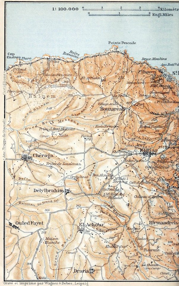
A favourite circular trip for one day (motor-cars and carriages, see p. 218) embraces El-Biar, Château-Neuf, Chéraga, Staouéli-Trappe, Sidi-Ferruch (p. 237), Guyotville (p. 237), Pointe-Pescade (p. 237), St. Eugène (p. 236), and Algiers. A popular drive for half-a-day includes Bouzaréah, Forêt de Baïnem, Bains Romains (p. 237), Pointe Pescade, and Algiers.
(1). The road to El-Biar leads from the old town through the Kasba and the Porte du Sahel (Pl. B, 3; comp. p. 228). Walkers 234may note two possible digressions. To the left, just outside the gate, a path descends in 10 min. to Boul. Laferrière (p. 226). To the right, 2 min. farther, diverges the Chemin de Fontaine-Fraîche (Pl. A, 3, 4), the road to (10 min.) the charmingly situated village of Birtraria, whence one may either ascend to the S.W. in 20 min. to El-Biar (see below), or walk to the N.E. through the pretty Frais-Vallon and then descend the Avenue du Frais-Vallon (Pl. A, B, 2, 1), on the right bank of the Oued M’Kacel, to (½ hr.) the Quartier Bab el-Oued (see below).
The highroad passes near the foot of the Fort l’Empereur (Pl. A, 4; 689 ft.), almost hidden by trees. This was the site of the camp of Charles V. (p. 221), and on it was built the Mulaï Hassan Fort (1545), which was partly blown up by its Turkish defenders when bombarded by the French in 1830. The road then winds up to the tramway station of St. Raphaël (788 ft.), whence a charming road branches off to (1¼ M.) Mustapha-Supérieur (to the left, and after 3 min. to the left again, joining the Chemin du Télemly close to the Hôt. Continental).
The large village of El-Biar (784 ft.), 2 M. to the S.W. of the Porte du Sahel, and the village of Château-Neuf (*Hôt.-Restaur. Mallard, pens. from 6 fr.; a favourite Sunday afternoon resort), lying on the monotonous plateau ½ M. beyond El-Biar, uninteresting in themselves, are the starting-points of the roads to the Colonne Voirol and to Bouzaréah (p. 235).
A road leads from Château-Neuf to (5½ M. from the Porte du Sahel) Chéraga (650 ft.; Hôt. des Voyageurs, humble), a pleasant village among fruit-trees, and (3 M.) Staouéli-Trappe (p. 237), situated on a shelf-like terrace above the coast, where the French first encountered the troops of the dey in 1830. The old Trappist monastery founded here in 1843 was purchased in 1904 by the Swiss Consul Borgeaud, who has converted the abbey-lands of about 3000 acres into a model farm (no admittance). The burial-ground contains the tomb of Col. Marengo (1787–1862).
From Staouéli-Trappe a road descends to the N.W. to (1 M.) Staouéli (p. 237). The highroad joins the Castiglione road at (11 M.) Sidi-Ferruch (p. 237), a station on the steam-tramway.
(2). To Bouzaréah a new road (2½ M.) leads to the N.W. from El-Biar (see above), through the pretty valley of the Oued bel-Elzar, one of the feeders of the Oued M’Kacel (see above), while the old road (2 M.) leads to it from Château-Neuf (see above), crossing an uninteresting plateau and, about ½ M. short of Bouzaréah, passing the Ecole Normale Primaire.
A more interesting route to (5 M.) Bouzaréah is from the Quartier Bab el-Oued (Pl. B, 1), formerly the N.W. suburb of Algiers, inhabited chiefly by Spaniards. From the Boul. du Général-Farre or Boul. Militaire Nord (Pl. C, 1; p. 222) we follow the Avenue de la Bouzaréah (Pl. C, B, 1) and the Avenue Beau-Fraisier, in the old suburb of Cité Bugeaud, to the Pont du Beau-Fraisier crossing 235the Oued M’Kacel. We thence ascend the fine Chemin des Carrières, passing near the blue-limestone quarries on the spurs of Mont Bouzaréah, then through a side-valley of the Frais-Vallon (p. 234), with its luxuriant vegetation, and lastly mount in windings past the Hospice des Vieillards.
The village of Bouzaréah (1230 ft.; Hôt. de France, humble; pop. 2500), in an open site on the crest of Mont Bouzaréah (1335 ft.), the culminating point of the Sahel, is a favourite goal for excursionists in summer. A road leads to the N.E. from the village, past the Fort de la Bouzaréah, on the left, and the Christian Cemetery, on the right, to (¾ M.) the Observatoire d’Alger (1148 ft.). The roof of the observatory affords a fine view of the Bay of Algiers and of the hills of Great Kabylia as far as Cape Bengut (p. 254).
From the Observatory we may descend either to the E. by the steep Chemin Sidi Ben-Nour, passing the fort of that name, to the Avenue des Consulats (see below), or to the N. by a steep and stony path to the Vallée des Consuls (p. 236).
A road leads to the N.W. from Bouzaréah in ¼ hr. to the poor huts of the Village Arabe de la Bouzaréah, on the slope of a flat hill (1178 ft.), overgrown with cacti and dwarf-palms, where we have a splendid *View of the forest of Baïnem, Cape Caxine (p. 237), the S.W. chain of the Sahel, with the ‘Tombeau de la Chrétienne’ (p. 238), and Jebel Chenoua (p. 242), as also of the Blida Atlas with the deep incision of the Chiffa Ravine (p. 215).
From the Arab village the road descends to the W. to the (1¼ M.) Forêt de Baïnem, the largest wood (1250 acres) near Algiers. We follow the ‘Route Forestière Wendling’, high on the slope of the Sahel, with a fine view of the coast between Pointe Pescade (p. 237) and Cape Caxine, at first through underwood, richly carpeted with flowers in spring. We then pass through the remains of a pine-forest to the (1¾ M.) Rond des Eucalyptus, a bifurcation in a small eucalyptus grove (straight on is the Route Forestière Mignerot leading to Guyotville, 3¼ M.; p. 237). We follow, to the right, the beautiful Route Forestière Combe (2 M.), which descends through groups of cork-trees, pines, and eucalypti, past a ravine, to the Maison Forestière, whence it is continued by a eucalyptus and mimosa avenue down to Villas (p. 237), on the Castiglione road, a station on the steam-tramway.
f. Notre-Dame d’Afrique and St. Eugène.
Tramway (No. 1, p. 218) to the Hôpital du Dey; thence an omnibus every ½ hr. (1–4 pers. 1 fr. 20 c.; each addit. pers. 30 c.) to the church of Notre-Dame d’Afrique.—Tramway (No. 7, p. 219) to St. Eugène. The terminus ‘Deux-Moulins’ is only a few paces from the station of the steam-tramway to Castiglione (R. 35).
The tramway through the Avenue des Consulats ends at the Hôpital Militaire du Dey (Pl. A, B, 1), which, with its gardens, occupies the site of a villa of Hassan Pasha (p. 225). We follow the Boul. de Champagne, and then diverge to the right by the Route de Notre-Dame d’Afrique (½ hr.), a narrow road, shady towards evening, affording splendid *Views of the Bay of Algiers.
236The large domed church of Notre-Dame d’Afrique (443 ft.), a pilgrimage-church for sick persons and mariners, founded by Card. Lavigerie in 1872, rises conspicuously on a spur of the N.E. slope of Mont Bouzaréah (p. 235), above the Christian and the Jewish burial-grounds (see below). From the terrace in front of the church, where the blessing of the sea by the clergy every Sunday at 3.30 attracts many spectators, we survey the coast as far as the Pointe Pescade (p. 237). Behind the church is the Hôt. Bompard.
The Vallée des Consuls, which has its name from the villas of the European consuls of the Turkish period, a shady and extremely fertile vale above St. Eugène (see below), affords charming walks. A pleasant road leads through it from Notre-Dame d’Afrique, shaded by gnarled old olive-trees. We may thence mount to the Observatory (comp. p. 235), or else descend in 20 min. to St. Eugène; but the descent viâ Fort Duperré to Deux-Moulins (p. 237) is very rough and fatiguing.
From the lower end of the Boul. du Général-Farre (p. 234), beyond the still uncompleted Quartier de l’Esplanade (Pl. C, 1), runs the Avenue Malakoff (Pl. C, B, 1), close to the shore and protected against the breakers by a high limestone wall, leading to the Fort des Anglais, an old Turkish fort on a rocky headland. Opposite, to the left, on the spurs of Mont Bouzaréah, lie the Christian Cemetery and the interesting Jewish Cemetery of Algiers.
Beyond the cemeteries we come to the little town of St. Eugène (Hôt.-Restaur, du Château-Vert, déj. 2½, D. 3 fr.; Restaur. Deux-Moulins; pop. 4800, incl. 500 Jews), with several factories and pretty villas. The tramway-terminus, Deux-Moulins, at the N.W. end of the town, is the starting-point for walks to the Pointe Pescade (p. 237), the Forêt de Baïnem (p. 235), and other places.
35. From Algiers to Tipaza and Cherchell.
a. Viâ Castiglione.
Steam Tramway (p. 219) from the station in the Quartier Bab el-Oued (Pl. B, 1 ; in connection with the electric tramway from Rue Waisse, Pl. C, 4) to (28½ M.) Castiglione; four trains daily in 2¾–3½ hrs. (fares 3 fr. 15, 2 fr. 30 c.).—Diligence from Castiglione three times daily to (5 M.) Bérard and twice daily viâ (43½ M.) Tipaza to (60½ M.) Cherchell. In order to visit the Tombeau de la Chrétienne we have to take a private vehicle (costing, from Castiglione to Tipaza, with a stay of 2–3 hours at the Ferme Seuillet or the Ferme du Rocher-Plat, about 12–15 fr.).
Interesting Round of Three Days: 1st. By early train to Castiglione; drive (taking provisions) to Ferme Seuillet (walk to Tombeau de la Chrétienne) and to Tipaza (see pp. 238, 239); there visit the E. hill, sending carr. on to the hotel.—2nd. Visit lighthouse and W. hill of Tipaza early; drive to Cherchell about noon (see pp. 242, 243).—3rd. Drive about noon to Marengo (see pp. 244, 243; lunch); take afternoon train to Blida, and evening train thence to Algiers.—Attractive but more costly, Four Days’ 237Round: 1st. By early train to Blida; by midday or evening train to Bou-Medfa; by omnibus to Hammam Rhira (p. 212).—2nd. By carr. from hotel to (16 M.) Marengo, and thence by steam-tramway (see pp. 243, 244) or by carr. to Cherchell.—3rd. Drive about noon to Tipaza (see pp. 243, 242).—4th. Tombeau de la Chrétienne; towards evening by steam-tramway from Castiglione back to Algiers.—Tours by Motor Car, comp. p. 173.
From Algiers to (3¾ M.) Deux-Moulins (St. Eugène), see pp. 235, 236. Here begins the finest part of the coast-road, which will repay walkers as far as Cape Caxine or Guyotville. The spurs of Mont Bouzaréah (p. 235), furrowed by many little ravines, come close down to the sea. The coast, undermined at places by the surf, presents a picturesque series of small headlands, bold cliffs, and rocky islets.
The most striking spot is the (5 M.) *Pointe Pescade (Restaurant), a headland crowned with the mouldering walls of a Turkish fort (1671), overlooking the blue sea and the coast as far as Cape Matifou and beyond.
By road and railway we next come to the (5½ M.) Bains Romains (Hôt.-Restaur.) and the Hôt. de la Fontaine Romaine, both sea-bathing places in summer, to (7 M.) Villas, lying below the Forêt de Baïnem (p. 235), and to (8 M.) Cape Caxine, on the gneiss rocks of which rises a Lighthouse (210 ft.; visible 24 M. round).
Beyond the precipitous Grand Rocher lies (9½ M.) St. Cloud-sur-Mer, a sea-bathing place. The coast now grows flatter.
10 M. Guyotville (82 ft.; Hôt. des Touristes, humble), a village of 3500 inhab., with a colony of Italian peasants, who cultivate early vegetables and grapes on the sandy soil, protected from the sea-winds by plantations of Spanish reeds (Arundo donax) and in spring by narrow fields of rye. On the plateau to the S. of the village, in the territory of the tribe of Beni-Messous, a number of dolmens (see pp. 324, 229) still exist.
From Guyotville to the Forêt de Baïnem, see p. 235.
Near the low headland of Râs Acrata the road reaches the broad *Bay of Castiglione, much exposed to N.W. gales, which extends in a slight curve to Jebel Chenoua (p. 242), a hill we sighted soon after leaving Guyotville. We have a view also of the pretty adjoining bay of Sidi-Ferruch. To the right, near (12½ M.) Les Dunes, part of the sand-hills is cultivated.
13 M. La Trappe and (14½ M.) Staouéli (Hôt. Malakoff, quite good) are stations for Staouéli-Trappe (p. 234).
From Staouéli and from the (15½ M.) Station Sidi-Ferruch roads lead to the N.W. (one 2¼, the other 2 M.) to the small sea-bathing village of Sidi-Ferruch (49 ft.; Hôt. de la Plage, plain), at the end of a sandy tongue of land formed by the surf and by the deposits of the Oued Mazafran (p. 238). It attracts also jackal-hunters and anglers from Algiers in winter. An inscription at the entrance to the Fort recalls the landing of French troops here in 2381830 (comp. p. 234). A little to the N.W. are the scanty remains of an Early Christian Church, with baptistery, etc.
As we proceed, the Atlas of Blida (p. 169) is visible for a time. 18 M. Zéralda (62 ft.; Hôt. de Zéralda), an agricultural village, lies in a broad coast-plain, the lowest of four old beach-terraces which mount to the N.E. in gigantic steps to Staouéli-Trappe.
The road now leads between low sand-hills, with pines and underwood, to the Oued Mazafran (called in its upper course Oued Chiffa, p. 213), through whose valley, deeply furrowing the Sahel, we have another glimpse of the Atlas of Blida.
22 M. Mazafran, on the left bank of the stream, is the junction of a branch-line to (6¼ M.) the little town of Koléa (460 ft.; Hôt. de France; Hôt. du Commerce), founded by Andalusian Moors in 1550, finely situated on the S. slope of the Sahel, and noted for its fruit-culture. The Jardin des Zouaves deserves a visit.
The next stations are for the use of villages situated above the line, on the N. margin of the Sahel plateau. 23½ M. Douaouda-les-Bains, 25½ M. Fouka-Marine, two small sea-bathing places. In the distance, on the crest of the Sahel, appears the Tombeau de la Chrétienne, resembling a haystack.
28½ M. Castiglione (128 ft.; Hôt. du Tapis-Vert, good; Hôt. de Paris; Hôt. de l’Oasis, humble) is a large village of 2000 inhab., on the vine-clad slope of the Sahel. Below are the unpretending sea-baths, where lodgings may be procured.
The High Road to (43½ M.) Tipaza, affording at first a beautiful view of the coast, of Jebel Chenoua, and the hills of the Dahra (p. 209) beyond Marengo, leads viâ the fishing-villages of (30 M.) Chiffalo (founded by Sicilian fishermen from Cefalù) and (31 M.) Bou-Haroun, whose inhabitants are engaged in the anchovy and sardine fishery, to (33½ M.) Bérard (66 ft.; Café-Hôt. Bérard, poor), a banana-growing village.
36 M. Ferme Seuillet (102 ft.), a large farm, is the starting-point for the Tombeau de la Chrétienne. The rough road to the tomb (2½ M.) ascends in windings (partly avoided, after 10 min., by a short-cut to the left), at first through underwood, and then to the S.W. through vineyards.
The so-called *Tombeau de la Chrétienne (856 ft.; Arabic Kbûr er-Rûmia), the largest tomb in the Atlas regions and one of the most conspicuous of sailors’ landmarks on the whole coast of Algeria, stands on one of the highest points of the S.W. range of the Sahel. It was probably erected by Juba II. (p. 244), in imitation of the Medracen (p. 274), as a tomb for his family. The building consists of a low square pedestal, of about 70 yds. each way, and a circular substructure relieved by sixty Ionic half-columns and four blind portals, crowned with a pyramid rising in steps, of which 33 still exist. The present name is derived from the cruciform 239mouldings of the door-panels. The monument, originally 130 ft. in height, but now 108 ft. only, has suffered severely from the vandalism of native treasure-hunters, who bored two tunnels into it, and from bombardment by two deys of Algiers, bent on the same quest. Further damage was done by earthquakes in 1825 and 1867, and the masonry also has been loosened by the removal of its leaden cramps. The building is surrounded by dense underwood and is partly overgrown by it on the N. side. Key and candles at the keeper’s hut on the N.E. side (fee 50 c.).
The Entrance is under the blind portal on the E. side, where the original vestibule has almost disappeared. A short passage leads to the antechamber; in the wall on the right, near two rude reliefs (lion and lioness), is a passage, once closed by stone slabs, with a flight of seven steps. Beyond this is a winding gallery, about 165 yds. long, probably destined for funeral processions, with small wall-niches for lamps. The gallery leads to the two inner chambers, an ante-room, and the larger chamber, with three wall-niches, in the centre of the monument, probably the tomb of the kings, but now quite empty.
The Ascent of the monument, from the S. side, rather a toilsome climb, conveys a still more striking idea of its grandeur than the long groping in the inside. The *Panorama from the top embraces the coast, from Sidi-Ferruch to Jebel Chenoua; the hills of the Dahra, with Jebel Zaccar Chergui (p. 212) to the S.W.; the broad Mitidja plain to the S.; and the Atlas of Blida with the ravine of the Chiffa.
We return to the Ferme Seuillet by the same route, or descend to the N.W. by the steep road to (37½ M.) the Ferme du Rocher-Plat (85 ft.).
The highroad next passes the (42 M.) Ferme Demonchy, intersects a beautiful eucalyptus-grove, and passes the E. hill of Tipaza (p. 242). In approaching Tipaza we obtain a charming view of its little bay and the lighthouse.
43½ M. Tipaza.—Hotel. Hôtel du Rivage, prettily situated at the S. base of the lighthouse hill, with a small garden, R. 2½, B. ½, déj. or D. 2½–3, pens. 7 fr.
Tipaza, a small seaport of 2000 inhab., mostly Mohammedans, founded in 1854, stands on the ruins of Tipasa, a place with a Berber name, but originally an ancient Phœnician settlement, and from the time of Emp. Claudius (about 40 A. D.) a Roman colony. Thanks to its advantageous site near the Nador valley, the main outlet in Roman times of the densely-populated W. Mitidja, Tipasa became in the 2nd cent. one of the most prosperous seaports of Mauretania. The most glorious period in its history was at the close of the 4th cent. when Tipasa, famed for its staunch adherence to the Catholic faith, repelled the attacks of Firmus, the Berber prince (p. 244); but after a century of prosperity most of the inhabitants fled to Spain in 484 in order to escape from the persecutions of Hunerich, king of the Vandals. Since its occupation by the Arabs the old town, already much impoverished, has disappeared from the page of history.
240The site of Tipaza, secluded and peaceful, is strikingly picturesque. The adjoining coast is richly varied, and close by rise the great limestone rocks of Mt. Chenoua. At the same time there are remains of numerous Roman and early-Christian buildings around, all in complete ruin, and partly overgrown with luxuriant vegetation.
Ancient Tipasa, originally occupying only the central castle-hill, which now bears the lighthouse (see below), gradually extended over the coast-plain to the S. of the bay, and also along the slopes of the W. and E. hills. The late-Roman Town Walls, 2410 yds. in length, are still traceable at places. The busy trade of the port led, probably at an early period, to the construction of a broad Landing Place with substantial quays, the space for which was obtained by the levelling of the rocky terrace on the coast. The Roman Outer Harbour, behind the rock-islets near the E. hill, probably served as a place of refuge in stormy weather only. Since the middle ages the coast-line has been much modified by the encroachments of the sea.
We begin our walk on the N. side of the village, at the present Harbour, which occupies the site of the now submerged Roman landing-place. The huge rock (possibly used as a mausoleum), undermined by the sea, which rises in the middle of the harbour, was left untouched by the Roman engineers. During the construction of the new harbour the remains of a Roman Cistern and underground Conduits were unearthed.
From the harbour we walk to the N., round a small bay, to the Lighthouse Hill (112 ft.), gorgeous with flowers in spring, where a few vestiges of Roman streets, cisterns, and a temple are traceable (see above). At the Lighthouse (phare) we obtain a delightful view. Near it, on the N. margin of the hill, a precipice has been formed by a landslip.
The road connecting the highroad with the harbour and the lighthouse hill leads past the Hôtel du Rivage and through the *Thermæ, a grand bath-house of the 2nd or 3rd cent., rivalling the W. baths of Cherchell (p. 246). Among the ruins, still 30 ft. high in places, extending into the Jardin Trémaux, the frigidarium on the E. side is still quite recognizable.
Near the hotel, to the left, we enter the Jardin Trémaux (adm. kindly granted), the garden of a private estate, adorned with antique and early-Christian relics. On the E. side, near the baths, we observe, protected by a roof, a fine late-Roman sarcophagus, bearing nuptial and sacrificial scenes. Near it is an old Christian sarcophagus, with Christ, the Good Shepherd (beardless); on the sides are lions tearing a gazelle to pieces.
In the middle of the grounds, to the left of the road, are a few relics of a Roman Amphitheatre (3rd cent.?), which even during the French period has served as a quarry.
241The road, farther on, passes the Nymphæum (on the left), a sumptuous late-Roman fountain (3rd or 4th cent.), 26 yds. in breadth, backed with a semicircular wall. In front of it is a platform 6½ ft. high, once bedecked with Corinthian columns and with statues, over which the water descended into a narrow trough or basin.
Immediately behind the fountain is a well-preserved vault, once the Reservoir for the water brought to Tipasa by an underground conduit, 5½ M. long, from the valley of the Nador. A few paces away are the noteworthy ruins of a Roman Mausoleum (1st cent.?).
The Roman Theatre, at the exit of the gardens, to the right of the park-road, yielded the materials for building the hospital of Marengo. Several tiers of seats are still traceable.
From the W. Gate, of whose round towers alone a few relics remain, we follow the vestiges of the town-walls to the N. W. to the (5 min.) West Hill (about 100 ft.), the Râs el-Knissa (‘church promontory’) of the natives.
A few paces to the right of the town-walls, just above the undermined margin of the coast-terrace, some fragments of a wall and two arcades of an aisle mark the site of the Bishop’s Church of Tipasa. Erected in the 4th cent., the church was a basilica, 57 yds. by 49 yds., with nave and triple aisles; the nave, 14½ yds. in breadth, was afterwards trisected by the addition of two rows of columns; little remains of the semicircular choir-recess.
Of the square Baptistery, on the N. side of the church, there remain the round font, with three steps, and fragments of the external walls. An adjoining chamber has a fine mosaic pavement; several other rooms show traces of a heating apparatus.
On the left, to the W. of the town-walls, lay the early-Christian Western Cemetery, with countless rock-tombs, sarcophagi, and monuments sadly desecrated by herds of cattle. About a hundred paces to the N. of the church, in the rocks rising above the sea, are several Grottes Funéraires. Near them is a large round Mausoleum, once adorned externally with sixteen half-columns, containing fourteen wall-niches (arcosolia) for coffins and the slab of a table for love-feasts (agapai).
About 2 min. to the S. W. is the Burial Church of Bishop Alexander, built at the end of the 4th cent., a small basilica with nave and aisles, of irregular shape, of which the foundations only remain. On the E. side is a rectangular altar-niche with nine sarcophagi, containing, as the eulogistic inscription in the nave declares, the remains of ‘the nine righteous men’ (probably the nine predecessors of Alexander). The right aisle contains many sarcophagi and a semicircular table for love-feasts. At the W. end of the nave are a mosaic with fish in seven rows and an inscription in memory of the founder, who was probably buried in the W. apse, added later, and accessible by a narrow portal only.
242We now return to the harbour, and ascend thence, close to the sea, past the remains of a small Roman Burial Ground, to the (10 min.) East Hill (115 ft.), outside the town-walls where thousands of graves indicate the great extent of the early-Christian Eastern Cemetery.
Here, beyond a few peasants’ huts, we reach the best-preserved ruin at Tipasa, the *Basilica of St. Salsa, the patron saint of the town. This church, built in the first half of the 4th cent, over the heathen sarcophagus of Fabia Salsa, was a square burial-chapel, about 16 yds. each way, with nave and aisles, but in the 5th or 6th cent. was prolonged westwards into a basilica 33½ yds. long, with a vestibule and with galleries over the aisles. At the same time the remains of the saint were transferred to a Roman sarcophagus, which was placed on a high pedestal in the old nave, now the choir of the enlarged church. The rows of clumsy columns in the nave are a later addition. The walls between the choir-pillars belong to a restoration of the 7th or 8th century. Among the ruins of the walls, still 10–12 ft. high at places, lie Ionic capitals and other fragments in picturesque confusion. Near the façade are preserved relics of the old stairs to the galleries.
The small Chapel and the square Hall (later a burial-place) on the S. side of the church date perhaps from the 4th century.
An *Excursion to Cape Chenoua will be found attractive. We first follow the Cherchell road for 1 M.; we then turn, beyond the Ferme Trémaux (p. 244), to the right and cross the Nador valley to the small sea-baths of Chenoua-Plage, at the E. base of Mt. Chenoua. A narrow road leads thence, up and down hill, along the beautiful Baie du Chenoua to the Anse des Grottes, which owes its name to the numerous caves in the limestone rocks (Grottes du Nador). On the narrow coast-terrace between (7½ M.) Cape Chenoua and the Râs el-Amouch is the secluded settlement of a French contractor, who with a staff of Spanish hands carries on a cement-factory and quarries the red marble of the cape, which was already known to the Romans.
The ascent of *Jebel Chenoua is interesting, both for the sake of the view from the top and for the glimpse it affords of its peculiar, purely Berber inhabitants. From the hilly coast-road just mentioned the route ascends to Tenzirt and (2–2¼ hrs.) a Pass (about 2300 ft.) between the two chief heights of the Chenoua. Thence in 40 min. more we reach the E. peak (2976 ft.), crowned with the kubba of Lalla Tefouredj (Berber Lalla Tzaforalz). The path descending from the pass to Desaix (see below) will be found convenient.
The Road from Tipaza to (17 M.) Cherchell (diligence, see p. 236) branches off to the W. from the Marengo road at (2 M.) Gué du Nador (p. 243), crosses the stream, and leads past (3 M.) Desaix (p. 244), through a bleak tract at the foot of Mt. Chenoua.
5½ M. Castellum du Nador, a late-Roman fortified country-seat (3rd or 4th cent.), was originally a quadrangular walled enclosure of 55 by 47 yds.; immediately to the left of the road there now remain the ruins of two round corner-towers and of a handsome gateway flanked with two square towers.
243The road leads on to the watershed, from which one has a view of the Atlas of Blida behind and the Dahra mountain spurs (p. 208) in front. Thence it dips into the valley of the Oued el-Hachem.
9½ M. Marabout Sidi-Ameur (164 ft.), on the left bank of the stream, at the junction of the Marengo road (p. 244).
About ¾ M. farther on we observe, on the left, the *Cherchell Aqueduct, coming from the village of Marceau, the largest Roman work of the kind in Algeria, which, rising in three tiers to a height of over 100 ft., here bridges a side-valley.
Passing several hill-farms, owned by French families, the road next turns to the N.W. into the valley of the Oued Bellah. Beyond the (14 M.) Café de l’Oasis we pass under the aqueduct, of which twenty pillars and five arches, built of great blocks of limestone, are still standing here at the foot of the beautiful pine-wood.
Beyond the aqueduct begins the finest part of the road. At first it skirts a pine-clad slope and then, leaving Cap Blanc to the N. E., leads to the W., up and down hill, along the coast. Lastly it passes the fissured Cape Zizerin and two saints’ tombs.
17 M. Cherchell, see p. 244.
b. Viâ El-Affroun and Marengo.
Railway (Algiers and Oran Line, R. 33) viâ (31½ M.) Blida (p. 213) to (43 M.) El-Affroun, six trains daily, in l–3/4–2¾ hrs. (7 fr. 75, 5 fr. 80, 4 fr. 25 c.).—Steam Tramway from El-Affroun viâ (12½ M.) Marengo to (30½ M.) Cherchell, two (as far as Marengo three) trains daily, in ca. 2¾ hrs.; fare 3 fr. 70 or 2 fr. 70 c.—For the combined visit to Tipaza and Cherchell, comp. also the diary on pp. 236, 237.
From Algiers to (43 M.) El-Affroun, see pp. 217–213. From the railway-station at El-Affroun the Steam Tramway runs to the W., at the foot of a range of low hills, through the plain of Mitidja, which is here very monotonous. To the right, on the crest of the Sahel, is the Tombeau de la Chrétienne (p. 238); in front of us rises Jebel Chenoua (p. 242). We pass the two poor villages of (3½ M.) Ameur-el-Aïn, and (8½ M.) Bourkika (345 ft.), where the road from Miliana and Hammam Rhira (p. 212) joins ours.
12½ M. Marengo (305 ft.; Hôt. d’Orient, Hôt. Marengo, both unpretending; carriages at the inns only; pop. 4300), a large agricultural village, has an important Wednesday *Market. About 5½ M. to the S. is the reservoir of the Oued Meurad.
The Road from Marengo to (8 M.) Tipaza (carr. 6–8 fr.) crosses the Oued Meurad and intersects the fine *Forêt de Sidi-Slîmân (‘Solomon’s Forest’), still primæval in character, with dense underwood and luxuriant ivy climbing to the tops of the trees.
At the Oued Nador, near the (6 M.) Gué du Nador, our road joins the Cherchell road (see p. 242). At the (7 M.) Ferme Trémaux it leaves the valley of the Nador, whose estuary is flanked with low sand-hills, and leads to the E. to (8 M.) Tipaza (p. 239).
244The highroad (carr. 12–15 fr.) from Marengo to (16 M.) Cherchell (see below) ascends to the W. from the Mitidja through a hilly region and after about 6 M. turns to the N. It joins the road from Tipaza to Cherchell at (10 M.) Marabout Sidi-Ameur (see p. 243).
Beyond Marengo the Railway crosses the highroad to Tipaza and then runs parallel to it to (17 M.) Desaix (220 ft.; p. 242). We skirt the S. side of Jebel Chenoua (p. 242).
20 M. Ruines Romaines. We cross the Oued el-Hachem (p. 243).
23 M. Zurich (263 ft.). The thriving village of that name, with a fine avenue of plane-trees, lies about 1½ M. to the S. of the station and is inhabited chiefly by natives, who cultivate oranges and vines. The great Thursday market is well attended by the Beni Menasser (see below).
Beyond Zurich the train runs to the W. of the Cherchell highroad. To the left lies the Cherchell Aqueduct (p. 243), while to the right Jebel Chenoua may be seen. 24 M. Bled Bakora; 25½ M. Bou-Hamoud; 27½ M. Oued-Bellah.
30½ M. Cherchell or Cherchel (108 ft.; Grand-Hôtel or Hôt. Nicolas, R. 2½, déj. or D. 2½ fr., plain but good, Hôt. Juba, humble, both in the Place Romaine; Hôt. de Valence; pop. 6800, incl. 4700 Mohammedans), a pleasant little seaport, lies on a narrow limestone plateau, an old coast-terrace, at the foot of green hills (750–800 ft.). Behind these hills rises a mountainous region, once well wooded, inhabited by the Berber tribe of the Beni Menasser.
Cherchell occupies the site of the ancient Phœnician colony of Iol. From the year 25 B. C. it took the name of Caesarea, and in the Roman imperial age it became the capital of Mauretania and residence of Juba II. (25 B. C. to 22 A. D.), one of the most learned and enlightened men of his time, under whom it rapidly rose to importance. Under Emp. Claudius it became the provincial capital, under the name of Colonia Claudia Caesarea, of Mauretania Cæsariensis, and in rivalry with Carthage and Hippo Regius (p. 309) grew to be one of the greatest and wealthiest cities of N. Africa. After the erection of Mauretania Sitifensis (p. 271) into a new province the prosperity of Cæsarea began to wane. About 371 its art and industry were almost annihilated by its capture and pillage by the Donatists (p. 172) under the Berber prince Firmus, and it lost the last vestige of its ancient glory when the Vandals transferred their residence to Carthage. In the 10th cent. the town is mentioned under the name of Cherchell, but from the 11th cent. onwards it was entirely deserted. At length, at the end of the 15th cent., it was revived by Andalusian Moors, who brought with them their famed potter’s art. In 1516 it was occupied by Horuk Barbarossa (p. 221), in 1531 it was unsuccessfully attacked by Admiral Andrea Doria (p. 115), and lastly, after being taken by the French, it was enclosed by a wall in 1843. As the harbour affords but little shelter the town has now little or no trade.
Archæologists may like to examine the scanty remains of the Roman Fortifications (2735 by 1640 yds.), which extend over the crest of the hill-range with its fine views; but the chief attraction is the Museum of sculptures of the period of Juba II., which form the only certain memorials of ancient Cæsarea, ‘an oasis of Greek culture in the midst of the Berbers’.
245The Place Romaine or Esplanade forms the nucleus of the little town. Among the trees here rises a Marble Fountain, composed of Roman architectural fragments found in the environs, remains perhaps of a palace of king Juba’s era (the four colossal masks are copies; see below). The Corinthian column and fragments of other columns at the back of the fountain were excavated in the Roman theatre (p. 246). The parapet of the Place Romaine affords a survey of the harbour (p. 247).
On the E. side of the Place Romaine rises the new *Museum, which consists of four galleries enclosing a central court. Among the sculptures exhibited here are admirable replicas of famous Greek works of the archaic and of the culminating periods of Greek art (5–4th cent.), which were executed by Greek masters for the adornment of king Juba’s residence. Adm. at any time; the custodian (½–1 fr.) shows also the Thermes de l’Ouest (see below). Catalogue (1902), 3 fr.; conservator, M. A. Munkel.
Passing through the Entrance Room (S.W. Pavilion; busts, statues, etc.) we enter the—
Salle Berbrugger (S. Gallery). 31. Marble statue of Venus; *1. Athena (torso), a copy in marble of a famous bronze by Alcamenes (5th cent.); 46. Torso of a youth or Dionysus, probably after a marble statue of the School of Praxiteles; 10, 13. Two torsos of Diana; 39 B. Female statue with the attributes of Ceres; 33 B. Aphrodite (or Proserpine); several draped female statues.—In the middle of this gallery are several marble heads on brackets: *64. Apollo, after an archaic Attic original (early 5th cent.); 69. Juba II. as a youth; without number, Agrippina.
South-East Pavilion. On the walls, mosaics (hunting-scenes, three Graces, etc.). In the centre, 11. Onyx statuette of Diana hunting; 109. Egyptian basalt statue of a king Thutmosis; 23. Marble group of Pan and a Satyr; 34. Venus.
The Salle Jonnart (E. Gallery) contains in glass-cases pottery, lamps, bronzes, glass, coins, etc. In the middle, casts of statues found at Cherchell but now in the Museum of Algiers.—We now cross the Central Court, with interesting architectural specimens, to the—
Salle Victor Waille (W. Gallery). 19. Hercules, after an original of the 5th cent.; *7. Dionysus; 19. Æsculapius, both after originals of the 4th cent.; *17G. Shepherd, replica of a work of Praxiteles; 21, 22. Two torsos of Hermes; *47. Torso of a youth.
North-West Pavilion. In the middle, draped female statue (Muse?), found in the theatre; numerous inscriptions; fragments of sculpture and architecture.
Salle Cagnat (N. Gallery). *39. Colossal female statue after a model by Phidias; 37. Canephor (archaic); 38. Hermaphrodite and a Satyr (Hellenistic). On the N. wall on brackets: Four colossal masks from king Juba’s palace mentioned above (Pergamenian School; 1st cent.).
North-East Pavilion. Inscriptions; several objects of Punic origin. In the centre, 68. Bust of Augustus; 49B. Muse.—Leaving this room by a door in the N. wall we enter a—
Court containing sarcophagi and numerous architectural fragments.
Leaving the Museum we cross the Place Romaine to its W. side, where we follow the third side-street (from the N.) to the W. and soon reach on the right, nearly opposite a little mosque, the *Thermes de l’Ouest (W. Baths), dating from the 2nd or 3rd 246cent., the grandest Roman ruins in the town, with walls still rising to a height of 10–13 ft. (concrete faced with brick) and bits of old mosaic pavement. Most of the antiques in the museum were found in these baths, in which they seem to have been collected in the early-Christian period.
The ancient Portico, on the E. side of the baths, once with granite columns 26 ft. high, is now embedded in the building of the Manutention, and on the S. side are several chambers hidden under the Prison Civile.
From the present entrance on the S. E. side we first come to a suite of five important chambers. The central hall, 26 by 16 yds., was probably the Frigidarium, which was flanked on three sides with smaller basins (piscinæ). The two narrow passages behind the S. and the N. basins show traces of the stairs that once ascended to the upper story.
On the W. side of the frigidarium is a room supposed to have been the Tepidarium, which, like its side-rooms, is accessible only by climbing over the walls. The hall behind the tepidarium, with its semicircular niche, was apparently the Caldarium.
The Baths command a delightful view of the sea and of the coast to the W., as far as Cape Ténès (p. 209).
Proceeding from the Thermes de l’Ouest we take the side-street at the mosque mentioned at p. 245 to the S. and reach the Rue de Ténès, the principal street of the town which leads to the W. (right) to the Porte de Ténès (see below). We, however, turn to the E. (left) and then follow the Rue du Centre, the first S. side-street. In the first side-street of the last, on the right, is the entrance to the famous old Chief Mosque ‘of the hundred columns’, completed in 1573, now the Military Hospital. Into the original ‘house of prayer’ a corridor and four hospital dormitories have been built; the antique columns, which are said to have been brought from the W. Baths, have been disfigured by a coating of paint.
At the S. end of the Rue du Centre, on the right, is a brick wall, the sole relic of the Roman Thermes du Centre.
A few paces to the left, on the hill-side above the Rue du Caire, are the remains of the Roman Theatre, unearthed in 1905. The E. side-entrance (parodos), between the stage and the auditorium, still exists, but the 27 tiers of seats were used for building the neighbouring barracks in 1845.
The Barracks of the Tirailleurs, on the hill above the theatre, stand on six antique Cisterns, once fed by the Cherchell aqueduct (p. 243). Passing through the Porte de Miliana, the S. gate behind the barracks, we may now follow a path through the fields to the ruined walls of the Roman Circus, once over 435 yds. long, which still lay within the ancient town-walls.
Outside the Porte de Ténès (comp. above), the W. town-gate, on the old Gunugu (Gouraya) road, lay several Roman Burial Grounds. A collection of objects unearthed here has been made by the commandant, M. Archambeau, at his country-seat ½ M. from the gate.
From the Roman Theatre we follow the winding street to the N. and reach the S. side of the Place Romaine at the Catholic Church, built in the pseudo-classical style. In front of the high-altar and at the end of the left aisle are two early-Christian mosaics.
247We may go down to the Harbour, either from the Place Romaine or viâ the W. Baths (p. 245), passing a large Roman Basin (piscina) and a ruined Turkish Fort of Horuk Barbarossa (p. 221).
The very shallow harbour, scarcely 5 acres in area, lying behind the fortified Ilot Joinville with its lighthouse, is probably identical with the Roman Naval Harbour, where part of the Alexandrian and Syrian fleet was always stationed to defend the coast against pirates. The short pier at the point of the lighthouse-island and an old embankment on the cliffs on the E. side of the bay protected the ancient Commercial Harbour.
To the E. of the Place Romaine and the Porte d’Alger, at the S.E. angle of the Champ de Manœuvres, are relics of the Thermes de l’Est (E. Baths), including part of the chief hall, 22 by 13 yds., with two niches.
From the highroad, 5 min. to the E. of the drilling-ground, a short path to the right leads to the foundation walls of the Roman Amphitheatre, overgrown with dense scrub. Since 1845 the ruins have served as a quarry.
36. From Algiers to Cape Matifou and to Aïn-Taya viâ Maison-Carrée.
20 M. Steam Tramway (p. 219), three trains daily (five on Sun. and holidays) in ca. 2¼ hrs. (fares 2 fr. 30, 1 fr. 65 c.).—Diligence from Rouïba (p. 249) to (4½ M.) Aïn-Taya twice daily, in 1 hr.—A pleasant drive may be taken from Algiers to Aïn-Taya direct.
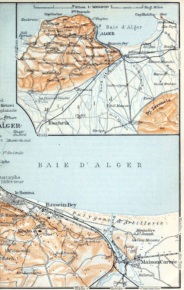
The Steam Tramway runs parallel with the railway through the S. E. suburbs of Algiers (p. 232), past the Jardin d’Essai (p. 232), and through the little town of Hussein-Dey (p. 233), to the railway-station of Maison-Carrée (p. 217). It then crosses the Harrach by a Turkish bridge of 1697.
7½ M. Maison-Carrée (66 ft.; Hôt. du Roulage, Hôt. de l’Harrach, both humble; pop. 7300, incl. 2700 Mohammedans and 3200 foreigners, mostly Spaniards), prettily situated on the right bank of the Harrach, amidst hills rising some 200 ft. above the stream, possesses an agricultural school and an interesting cattle-market (Frid.). It owes its name to the square Turkish Citadel, built in 1746, now the Prison de l’Harrach, used for native convicts.
About 1¼ M. to the N. of Maison-Carrée, near the sea, lies the Monastère St. Joseph, the headquarters of the Missions d’Afrique founded by Card. Lavigerie (p. 346), whose members owe their name of White Fathers (Pères Blancs) to their white gowns Arabian in appearance. The monastery owns an ethnographical collection from the interior of Africa.
From Maison-Carrée the steam-tramway mentioned at p. 219 runs across the Mitidja to (19 M.) L’Arba (335 ft.; Hôt. des Etrangers; Hôt. de l’Arba), a small town of 2300 inhab., with an important Wednesday market (Arabic arbáa), and then along the foot of the Atlas, partly through 248orange-groves, to (23 M.) Rovigo (361 ft.; Hôt. des Eaux-Thermales; Hôt. du Commerce; pop. 4200, chiefly Mohammedan). This is the station for (4½ M.) Hammam-Melouan (about 720 ft.), a small watering-place with hot saline springs, chiefly patronized by natives, in the narrow ravine of the Harrach.
A picturesque hill-road leads from L’Arba to (59 M.) Aumale (p. 250; diligence in 12 hrs.) viâ (14½ M.) Sakamody (2585 ft.), (47½ M.) Bir-Rabalou (2106 ft.), and (50½ M.) Les Trembles.
The Matifou road ascends to the top of the hill-chain and leads to the E. to the village of (10 M.) Retour-de-la-Chasse (75 ft.), 2 M. to the N.W. of railway-station Maison-Blanche (p. 249), and to (15½ M.) Rouïba (p. 249).
The Steam Tramway follows the direct road from Maison-Carrée to the N.E. to (12 M.) Fort-de-l’Eau (16 ft.; Hôt.-Restaur. du Casino, on the shore; Hôt. de la Plage and others, plain), a small sea-bathing place with many villas and a fine beach. Fine view of Algiers and the spurs of Mont Bouzaréah. The old Turkish coast-fort, Bordj el-Kifan, of 1581, stormed by the Foreign Legion in 1833, is now the Caserne de Douaniers. The village, noted for its banana-culture, is inhabited chiefly by ‘Mahonnais’ (p. 233).
From the village we proceed to the N.E., a little inland from the bay, which is now much choked with sand, through tame fields and underwood, to the Oued el-Hamiz. Here we turn to the N., soon obtaining a view of the broad Bay of Algiers and the distant Atlas of Blida, and traverse the extensive plateau of Cape Matifou (236 ft.; Arabic Râs Temendfus).
17 M. Matifou (210 ft.), a poor village, lies about 1½ M. to the E. of the site of the Roman town of Rusguniae, where, under the dense brushwood, the remains of baths and the foundations of an early-Christian basilica have been discovered. The church, originally with nave and aisles, was rebuilt in the Byzantine period with double aisles and a W. apse.
The small Harbour beyond the village, where Emp. Charles V. embarked the remnant of his army in 1541 (comp. p. 221), is now a quarantine station for vessels and a port for pilgrims (Mers el-Hadjadjeh). The Mohammedans returning from Mecca, usually including many Moroccans, have to spend several days here in the large Lazaretto built in 1884.
Besides the Bordj Temendfous, the interesting old Turkish fort, there are also on the peninsula the French Fort d’Estrées, a Lighthouse (207 ft.), visible from 32 M., and a Semaphore. On the shore, where there are traces of a breakwater, a large tunny-net (madrague) is set in summer. The fishermen are mostly Corsicans and S. Italians from the villages of La Pérouse and Jean-Bart.
Beyond Matifou we skirt the E. margin of the peninsula, soon sighting the fine coast of Great Kabylia as far as Cape Bengut (p. 254), and run to the S.E., past some Roman ruins, to the village of Aïn-Beïda.
20 M. Aïn-Taya (131 ft.; Hôt. du Figuier, R. 2–4, B. ¾, déj. or D. 2½–3, pens. 6–7 fr., quite good), a pleasant agricultural village, is inhabited chiefly by Spaniards. From the chief place 249a short avenue of plane-trees and palms leads to the N.E. to the steep edge of the coast and the fine bathing-beach.
From the S. margin of the plateau, on the highroad beyond Aïn-Taya, we obtain a delightful *View of the E. Mitidja with its girdle of mountains. The road then descends to (24½ M.) Rouïba (see below), whence we may take the train back to Algiers or else to Menerville (p. 250).
37. From Algiers to Bougie viâ Beni-Mansour.
162 M. Railway, in 7¾. hrs. By the Constantine morning-express (p. 269) in 4¾ hrs. to Beni-Mansour (Rail. Restaurant; meals at Bouïra or at Bougie should be ordered beforehand) where carriages are changed; thence by ordinary train to (3 hrs.) Bougie (fares 29 fr. 20, 20 fr. 85, 15 fr. 65 c.). The Constantine night-express (p. 269) may be taken as far as Bouïra, where in this case the rest of the night must be spent.—Or we may take the Motor Omnibus from Algiers to Bouïra.—Sea Voyage from Algiers to Bougie, comp. R. 22.
From Algiers to (7½ M.) Maison-Carrée, see p. 247. Here our line, which forms part of the main E. Algerian line to Constantine (R. 43) and Biskra (R. 44) diverges from the Oran line (R. 33) to the S.E. The train crosses the Harrach and skirts the S. side of the hills near Maison-Carrée. View, to the right, of the Tell Atlas and the serrated Jebel Bou-Zegza (3386 ft.).
Beyond (12 M.) Maison-Blanche (36 ft.) the plateau adjoining Cape Matifou (p. 248) appears on the left. We cross the Oued el-Hamiz.
16 M. Rouïba (60 ft.; Hôt. Glacier; Hôt. de France), a large village in the most fertile part of the E. Mitidja, with many vineyards. Diligence to (4½ M.) Aïn-Taya, see pp. 247, 248.
20 M. Réghaïa. We cross the Oued Réghaïa and pass through the so-called Forêt de la Réghaïa, with its sparse cork-trees.
24½ M. Alma (66 ft.; Hôt. du Cheval-Blanc; Hôt. d’Europe, etc.), ¾ M. to the S. of the station, occupies an idyllic site among hills on the left bank of the Oued Boudouahou.
The High Road leads from the right bank of the Boudouahou in long windings through the beautiful hill-country of the Sahel, which flanks the N. side of the Tell Atlas. Passing mostly through underwood it crosses the Oued Corso, and leads viâ the villages of Ste. Marie-du-Corso (125 ft.) and Belle-Fontaine (p. 250), on the left, to Ménerville (p. 250).
The railway, carried partly through cuttings, intersects the Sahel to the N.E. 26 M. Corso-Tahtâni (118 ft.), ¾ M. from the sea, near the mouth of the Oued Corso. To the left we have a brief outlook towards the sea. In the foreground rise the hills of the Sahel as far as Cape Djinet (p. 253).
The train leaves the coast, passing at places through cuttings and between pleasant hills planted with mimosa, and enters, to the 250S.E., the vale of the Oued Bou Merdès, resplendent in spring with its mantle of golden broom.
30½ M. Belle-Fontaine (167 ft.); the village lies on a fine open hill to the right (466 ft.). We next pass between mimosa-clad hills, backed by wooded mountains, and through a defile which forms the portal of the Isser valley and Great Kabylia (p. 252).
34 M. Ménerville (492 ft.; Hôt. Blanchard, plain but good), on the Col des Beni-Aïcha, a dirty village of 3000 inhab., is the junction for Tizi-Ouzou (R. 38).
Our line descends to the S.E. into the valley of the Isser, and then ascends on its left bank. 38 M. Souk el-Haad (230 ft.).
Beyond (40½ M.) Beni-Amran (420 ft.) begins the grand Ravine of the Isser (Gorges de Palestro or des Beni-Hinni), which pierces the Massif des Beni-Kalfoun, 4½ M. long, rivalling the gorge of the Chiffa (p. 215). Views chiefly to the right; but owing to the numerous tunnels we see little of the bold limestone rocks.
48 M. Palestro (525 ft.; Hôt. de France, déj. 2 fr., Hôt. du Commerce, both humble), a poor village of 600 inhab. (with Wednesday market), defended by a fort, lies in the fertile central section of the Isser valley. Near it rises Jebel Tegrimoun or Tegrimont (3373 ft.), the highest of the Massif des Beni-Kalfoun (see above), commanding the famous view of the Jurjura Mts. (p. 258).
Beyond (55 M.) Thiers (624 ft.) the train leaves the Isser, offering a glimpse of the head of its valley to the right, and turns to the E. into the tame valley of its tributary Oued Djemâa.
61½ M. Aomar-Dra el-Mizan (778 ft.), station for Aomar (1266 ft.) and (7½ M.) Dra el-Mizan (p. 254; diligence).
The train runs to the S. E. along the foot of the Beni Smaïl Mts. (p. 254), and then, curving far round to the E., ascends rapidly to the head of the valley of the Djemâa, here called Oued Bezzit, and to the Col de Dra el-Khemis (1962 ft.), the saddle between the W. Jurjura range and the hills of Aïn-Bessem (see below). Threading a tunnel the train then descends to the S. to the Plaine du Hamza, the upper region of the Oued Eddous valley (called Oued Sahel lower down; p. 251).
76½ M. Bouïra (1722 ft.; Rail. Restaur.; Hôt. de la Colonie, R. 2–3, B. ¾–1, déj. 2½, D. 3 fr.; Hôt. des Voyageurs; pop. 7500), a small town with an old Turkish fort and a great Saturday market largely attended by Kabyles (p. 252), is connected by hill-paths with Boghni (p. 254) and Fort-National (p. 257).
A Road (diligence twice daily) leads to the S.W. from Bouïra through the valley of the Oued Lekhal to (15½ M.) Aïn-Bessem (2221 ft.) in the Plaine des Aribs, and thence to the S. to (29 M.) Aumale (2907 ft.; Hôt. Grossat, R. 2½, déj. 3, D. 3½, pens. 10–12 fr.; Hôt. Raveu; pop. 6100), a little town on the N.E. spurs of Jebel Dira (5938 ft.). This was the ancient Auzia, an important station on the Roman road to Mauretania (p. 124), of which numerous epigraphical monuments are now in the Museum.
251A beautiful road (p. 248) leads from Aumale to L’Arba and Algiers; another to (20 M.) Sidi-Aïssa and (84 M.) Bou-Saâda (p. 270; diligence at 11 a.m., in 22 hrs.).
The train now descends to the E., on the right bank of the Oued Eddous; on the left tower the rocks of the Jurjura (Jebel Haïzer and Jebel Akouker, p. 258). 85 M. El-Esnam. 93½ M. El-Adjiba (1247 ft.), near the influx of the Oued Zaïane into the Eddous, which now takes the name of Oued Sahel (the ancient Navasath).
From El-Adjiba across the Tizi n-Assoual to Fort-National, see p. 258.
100½ M. Maillot (1477 ft.; Hôt. des Voyageurs, R. 2 fr., déj. or D. 2 fr., Hôt. de la Poste, Hôt. de l’Union, all poor), a small village 2½ M. to the N. of the station (about 1050 ft.; diligence meets some of the trains), lies on the slope of the Lalla Khedidja (7572 ft.; p. 259), the highest peak of the Jurjura, famed for its cedar-forests (comp. p. 210).
From Maillot viâ the Tirourda Pass to Michelet, Fort-National, and Tizi-Ouzou, see R. 39; viâ Fort-National to Azazga (Bougie), R. 40.
107 M. Beni-Mansour (948 ft.; Rail. Restaurant, déj. or D. 3 fr., good), junction of the main line to Constantine and Biskra (RR. 43, 44) with the Bougie branch, lies on the boundary between the provinces of Algiers and Constantine. Near it is the finely situated old French fort, Bordj de Beni-Mansour, now a school. Sunday market near the station.
The Bougie line (change carriages) crosses the Oued Mahrir (p. 269), near its influx into the Oued Sahel, and crosses the latter near the mouth of the Oued Tixiriden (p. 260).
112 M. Tazmalt (902 ft.; Hôt. des Voyageurs), ½ M. to the N.W. of the station, the first village in the province of Constantine, with extensive olive-groves, lies near the Oued Beni Mellikeuch. This, like Maillot, is a station for the Tirourda Pass (R. 39).—To the S. of the railway rise the Beni Abbès Mts.
Below (115 M.) Allaghan (774 ft.) the Sahel valley contracts. On the left rises the Piton d’Akbou, crowned with a late-Roman tomb of the 3rd cent, (a step-pyramid on a square base), but not visible from the train. On the right, beyond the mouth of the copious Oued Bou Sellam (p. 269), which rises in the mountains of Little Kabylia (p. 266), the serrated Jebel Gueldaman (2638 ft.) juts far into the valley.
122 M. Akbou (1050 ft.; Hôt. du Sahel; Hôt. Bellevue; pop. 1200; Mon. market), a large village, is the starting-point of a path to the Col de Chellata (p. 260). Grand eucalypti in the environs.
Far away to the left as we proceed towers Jebel Arbalou (p. 262). 126 M. Azib-ben-Ali-Chérif (512 ft.); 128½, M. Ighzer-Amokran, at the mouth of the brook of that name. The broad floor of the valley is clothed with meagre underwood.
133 M. Takritz, or Takriets (364 ft.), is the station also for Seddouk, 5½ M. to the S.E.; 136 M. Sidi-Aïch (295 ft.) has a 252Wednesday market well attended by the neighbouring Fenaïa (p. 261) and Beni Himmel tribes. Olives abound on the hill-sides farther on; in the valley below is a small grove of fig-trees.
142 M. Il-Maten (361 ft.), on the left bank of the Sahel, whose valley, now called La Soummam, is fever-stricken lower down.
On the left bank of the Sahel, near Tiklat, a village about halfway between Il-Maten and El-Kseur, are the interesting ruins of the Roman town of Thubusuctu or Thubusuptus. Fragments of the walls of the baths, 33 ft. high, are still standing; the great Cisternes d’El-Arouia are 83 yds. long and 41 yds. wide; and there are relics of two aqueducts besides many tombs.
147 M. El-Kseur-Amizour. The village of El-Kseur (p. 261) lies ½ M. to the N., on the Azazga road; that of Oued-Amizour is 3¾ M. to the S.E. of the station. 149½ M. Tombeau de la Neige.
154½ M. La Réunion (53 ft.), on the slope to the left, is near the mouth of the Oued Rhir or Ghir. Road (8 M.) to Toudja (p. 262).
The train, running to the N.E., now enters the plain at the mouth of the Sahel. Fine view, to the right, of the Gulf of Bougie and the hills of Little Kabylia. In the foreground, beyond the wooded and fertile Plaine, watered by the Oued Srir, appears Jebel Gouraya (p. 265).
162 M. Bougie, see p. 262.
38. From Algiers to Tizi-Ouzou. From Camp-du-Maréchal to Tigzirt.
From Algiers to Tizi-Ouzou, 66½ M., railway in 3½–6¾ hrs.; fares 12 fr., 8 fr. 55, 6 fr. 45 c.; 1st cl. return 16 fr. 90 c. (to Camp-du-Maréchal, 56 M., in 3–5¾ hrs.; fares 10 fr. 10, 7 fr. 20, 5 fr. 40 c.).—From Camp-du-Maréchal to Dellys, 19½ M., light railway in ca. 1¾ hr. (2 fr. 35 or 1 fr. 70 c.).—From Dellys to Tigzirt, 16 M., diligence in 3 hrs. (at night only).—Motoring Tours, comp. p. 173.
The railway to Tizi-Ouzou forms the chief approach to Great Kabylia or Grande Kabylie, for which the best season is April or May, when the bare limestone peaks of the Jurjura (p. 258) are still capped with their winter snow, while the lower hills are clothed with the fresh verdure of spring. Most travellers are satisfied with a visit to Fort-National and Michelet and the drive across the Tirourda Pass (R. 39) but the long route from Fort-National to Bougie viâ Azazga and Taourirt-Ighil (R. 40) also is quite interesting. Beautiful coast scenery between Dellys and Tigzirt. The ruins at the latter will interest archæologists. The hotel-charges are everywhere disproportionate to the services rendered, and the cuisine is generally indifferent. Fairly good quarters are to be found only at Tizi-Ouzou, Tigzirt, Michelet, Azazga, and Taourirt-Ighil.
The so-called Kabyles (from the Arabic kebila, tribe) consisted, as far back as the Roman period, of five Berber tribes, united to form a state with a democratic constitution. In their remote mountain villages (thaddart) they successively repelled the attacks of the Romans, the Arabs, and the Turks, and it was not till 1852–7 that the French after protracted struggles succeeded in subduing them. During the Turkish period they were called Zuawas, whence the modern French Zouaves derive their name. Their language is a Berber dialect mingled with Latin and Arabic words. The men in the over-peopled W. and S. regions often migrate 253to the Algerian towns and even to foreign countries as hawkers (iattaren), or to the Mitidja as harvest labourers. The women, who are unveiled and often adorned with valuable trinkets, are seen to advantage at the wells. Many of the girls have pretty faces and good figures.
From Algiers to (34 M.) Ménerville, see pp. 249, 250. To the left of the train, halfway to Félix-Faure, is the so-called Mausolée de Blad-Guitoun, the sadly dilapidated tomb, originally 33 ft. high, of a Christian Berber prince (4th or 5th cent.), in the style of the later Djedar (p. 208), but with an octagonal base. The interior, like that of the Tombeau de la Chrétienne (p. 238), contains a lion in relief, a winding gallery, and a tomb-chamber. The pyramid with its steps has disappeared.
38 M. Félix-Faure-Courbet. From the village of Félix-Faure (236 ft.), formerly called Blad-Guitoun, near the station, a road (diligence twice daily) leads to the N. through the hilly Sahel to (4½ M.) Zaatra and (5½ M.) Courbet (253 ft.), two villages chiefly inhabited by settlers from Alsace and Lorraine.
The road ends at (8¾ M.) Port-aux-Poules or Mers el-Hadjadjeh (p. 248), a decayed seaport on the site of the Roman Rusubricari, the ruins of which have been almost entirely swept away by the waves.
The train crosses the Isser by viaducts of 110 and 160 yds. in length. 40½ M. Les Issers (82 ft.; Hôt. du Marché, Hôt. des Issers, both humble) is the station for Isserville (213 ft.; Hôt. Sigé), which holds a busy Thursday market. Diligence to (24½ M.) Dra el-Mizan (p. 254).
43½ M. Bordj-Ménaïel (53 ft.; Hôt. du Roulage; pop. 1100) holds market on Fridays.
A Road leads to the N. from Bordj-Ménaïel through the Isser valley, avoiding the sand-hills at the mouth of the stream, and then skirting Jebel Djinet, the ‘frontier pillar’ of Great Kabylia, to (10 M.) the small bay, opening towards the W., of Mersa Djinet, near Cape Djinet (164 ft.), whose basalt-quarries have yielded paving-stones for Algiers.
The train leaves the Isser and ascends to the E. in the valley of the Oued Chender to (51 M.) Haussonvillers (492 ft.; Hôt. des Postes), peopled by settlers from Alsace-Lorraine. We are now carried over four viaducts, each over 100 ft. high, and through tunnels on the N. slope of the finely-shaped Beni Mekla hills (2920 ft.), down to the Sebaou Valley, the chief valley of Great Kabylia. In the distance appears Jebel Belloua (p. 254).
56 M. Camp-du-Maréchal (184 ft.; Hôt. Frœliger), peopled by Alsace-Lorrainers, has a Tuesday and a Thursday market. Cork-tree woods in the environs.
From Camp-du-Maréchal to Dellys and Tigzirt, see pp. 254, 255.
We cross the Bougdoura. 60½ M. Mirabeau (154 ft.; Hôt. Caratero, humble).
From Mirabeau to Boghni, 18¾ M., light railway (continuation of the line from Dellys), in ca. 1¾ hr. (2 fr. 25 or 1 fr. 65 c.). The train at first runs to the S. on the Dra el-Mizan road (p. 254), through a eucalyptus avenue in the broad and featureless lower valley of the Bougdoura, to beyond (4½ M.) Tléta. A little farther on it leaves the highroad and penetrates 254very narrow cuttings up the winding upper Bougdoura valley, past (12 M.) Maatkas, in the territory of the tribe of that name, to (18¾ M.) Boghni (755 ft.; Hôt. Ricard, Hôt. Grossiard, both humble). The little village lies in the fertile green valley of the stream, here called Oued Boghni, between the lower hills and Jebel Haïzer or Haïzeur, the chief peaks of which are Râs Tachgagalt or Pic Ficheur (7044 ft.) to the E. and Tamgout Haïzer (6965 ft.) to the W. From Boghni to Aïn-Sultan and Fort-National, see pp. 258, 257.
From Mirabeau to Dra el-Mizan (26 M.). The highroad, beyond the cuttings near Tléta (p. 253), crosses the Bougdoura and runs to the W. for a short time in the valley of the Oued Aguergoun, in view of the fine S. slopes of the Beni Mekla Mts. (p. 253). It then bends to the S.W. into the pretty and secluded valley of the Acif Tléta or Oued Kessari, which here intersects the lower hills and for a distance of 17 M. contains not a single human habitation. The hill-sides, however, are carefully cultivated by the neighbouring villagers, and are well planted with fig and olive-trees, eucalypti, and cork-oaks. We then ascend a high plateau, with a superb view of Jebel Haïzer (see above), to the village of (26 M.) Dra el-Mizan (1525 ft.; Hôt. Bellevue, Hôt. du Commerce, both humble), once famed for its textile fabrics, situated on the N.W. spurs of the Beni Smaïl Mts. (p. 250; 10 M. to the W. of Boghni; diligence). A picturesque road (7½ M.; diligence) leads from Dra el-Mizan, to the S.W., across the Tizi el-Arba (beyond this, another view of Jebel Haïzer), to the rail. station of Aomar-Dra el-Mizan (p. 250).
The train next crosses the Oued Sebt, approaches the Sebaou after a long bend to the N., and then ascends past the Alsatian village of (64½ M.) Bou-Khalfa (161 ft.), near the wooded W. slope of the finely situated Jebel Belloua (2280 ft.).
66½ M. Tizi-Ouzou (620 ft.; Hôt. Lagarde, R. 3–5, B. 1¼, déj. 3, D. 3½, omn. ½ fr., quite good; Hôt. du Square and Hôt. du Roulage, unpretending; pop. 29,620), the chief town and market (Sat.) in the interior of Great Kabylia. Jebel Belloua may be ascended hence, and the poor and dirty Kabyle village at the N. end of the little town may be visited by the curious.
From Tizi-Ouzou to Fort National and Michelet (Tirourda Pass), see R. 39.
The Light Railway to Dellys (19½ M.; p. 252) descends to the N. from Camp-du-Maréchal (p. 253) through the broad Sebaou Valley, past unimportant stations; then, near the mouth of the stream, it turns to the N.E., away from the highroad, and skirts the coast, which is at first flat and sandy and afterwards bold, and abrupt. To the left rises the lighthouse, famed for its view, on Cape Bengut (207 ft.), a spur of Jebel Ouamri (1227 ft.), composed partly of basalt and other eruptive rocks.
We now proceed to the E., at first through orchards and then on an embankment 26 ft. high, on the brink of a grand abraded terrace, 1 M. long, flanked with narrow perpendicular ledges of sandstone. We then pass through a short tunnel under the ‘dagger-pointed’ Cape Dellys.