VII. TUNISIA. (continued 2)
Reading edition
The Cathedral (Primatiale de St. Cyprien et de St. Louis), a basilica with nave and two aisles, built in 1884–90 by Abbé Pougnet, in the Byzantine-Moorish style, contains (in the choir) the archiepiscopal throne and the tomb of Card. Lavigerie (p. 346). Over the high-altar is the valuable reliquary of St. Louis, executed by Armand Caillat, a goldsmith of Lyons. Adm. from 5 to 11.15 and 12.30 to 5.30 (in summer 6.45).
The limestone blocks on the S.W. side of the cathedral, near the small eucalyptus grove, are remains of the stylobate of a Roman Temple. From the brow of the hill we obtain a good survey of 348the site of the ancient naval harbour (p. 345) and of the Roman circus (see below). The view of Lake Bahira is charming at sunset.
Between the brow of the hill and the road descending to Douar ech-Chott (p. 344) Père Delattre’s excavations have brought to light a number of buildings a thousand years apart in date. Above, on the margin of the hill, is an interesting Punic Necropolis with rock-tombs; lower down are remains of the Town Walls, hastily restored under Theodosius II. (p. 541) in 424, and traces of the Roman Road leading to the harbour; then Punic tombs again, and below them the foundations of a Byzantine Dwelling House (a room here contains early-Moorish tombs).
Below the S. angle of the castle-hill we come upon ancient fortifications. Farther down is a wall or buttress composed of thousands of early-Roman earthenware amphoræ; also a rock-hewn Chapel (key at the Seminary) with remains of wall-paintings (saint bestowing a blessing) in the style of the catacomb frescoes.
Time permitting, we follow the Sidi-Daoud road to the N.W. from the castle-hill, cross the Goletta and La Marsa highroad, and reach (¼ hr.) the Roman Amphitheatre, which has been broken up only since the 16th cent., and which Edrisi, the geographer (1154), has described as one of almost matchless splendour. All that is left of it consists of a few remains of substructures deeply imbedded in rubbish, several underground passages, and in the centre of the arena (where a chapel with a cross recalls the martyrs Perpetua and Felicitas, p. 350) three underground chambers, probably for the machinery used in theatrical performances.
To the S., not far from Douar ech-Chott (p. 344), are a few vestiges of the Roman Circus. It measured 770 by 110 yds.; the Spina, or partition round which the racing chariots passed, was 380 yds. long.
Scarcely a hundred paces to the N.W. of the amphitheatre, near a farm-building, is a Burial Ground of the Officiales (1st–2nd cent.), the imperial freedmen and slaves employed in the proconsul’s office (tabularium).—Beyond the amphitheatre the road passes a second Burial Ground of the same kind on the right and the foundations of the Villa of Scorpianus (identified by the inscription ‘Scorpianus in adamatu’) on the left.
To the W. of the highroad, 12 min. from the castle-hill, lies the dirty village of La Malga (82 ft.), which swarms with begging children. On the N.E. side of the village are scanty ruins of Roman Thermae. The Cisterns in the middle of the village, 15 (originally 24) barrel-vaults now in a very ruinous condition and partly used by the natives as dwellings or stables, once formed the chief reservoir fed by the Roman Aqueduct (pp. 329, 353, 358), begun under Hadrian in 117, but not completed till 163. The whole city was supplied thence by means of leaden pipes.
A Roman Road leads almost in a straight line from La Malga, to the N.E., close past Damous el-Karita (p. 349) and past the Basilica Maiorum (p. 350), to the Arrêt de la Briqueterie (p. 344).
349From La Malga we follow the road to the S.E., past the Croix de St. Cyprien, a memorial of the famous bishop (pp. 345, 346), along the course of the old ‘Conduit Souterrain’, to the Abbey Hill (171 ft.), often groundlessly called Colline de Junon, rising to the N.E. of the castle-hill. Here are situated the Monastère du Carmel, a Carmelite nunnery, and the Petit Séminaire, the original mission-house of the White Fathers, now an orphanage presided over by the Sœurs Missionnaires d’Afrique, a sisterhood also instituted by Card. Lavigerie. On the roadside, between these buildings, remains of Roman Houses and Cisterns have been excavated.
On the slope of the Odeon Plateau (181 ft.), the N.E. continuation of the abbey-hill, near the bridge of the electric tramway, and 3 min. to the left of the upper Carthage and Sidi Bou-Saïd road (p. 350), are relics of the Roman Theatre, including several rows of the seats of the cavea (p. 293) and parts of the stage-building. After the partial restoration of the theatre a grand performance took place here in 1908 and similar representations will be occasionally repeated.—A few paces to the S.W. of the stage we come to the foundations of a small Roman Temple Circulaire. To the N.E. of the theatre, on the S.E. slope of the plateau, are the more considerable remains of Roman Houses, but these have recently been threatened with demolition.
On the plateau itself, about a hundred paces above the theatre, in the midst of a Punic Necropolis (3rd cent. B.C.), are relics of pavement and several underground passages marking the site of the Odeon, a roofed theatre (theatrum tectum) for concerts, built under the proconsul Vigellius Saturninus (about 212 A.D.). Both the theatre and the odeon are said to have been destroyed by the Vandals in 439.
Outside the old town-wall (p. 345), about 135 yds. to the N. of the Odeon, and 3 min. to the W. of station Ste. Monique (p. 344), lies an extensive early-Christian cemetery, in the centre of which lie the ruins of Damous el-Karita (domus caritatis?), a great basilica. This church, 71 by 49 yds., was built at different periods. The oldest basilica with its ten aisles (4th cent.) was orientated to the S.E., and the second, with eight aisles, probably of the Vandal period, was turned towards the S.W. A third building, again with ten aisles, evidenced by its reduced size the decline of Carthage in the Byzantine period, as it consisted only of the old transept converted into a nave and of the four N.W. aisles of the second basilica. Within the oldest nave, in the axis of the first choir-recess, a new apse was erected. The ⟙-shaped building thus resulting, with its very short and many-aisled body, seems to have been the model on which Hassan ibn en-Nôman built the Kairwan mosque, as well as the source of much of its material (comp. pp. 374, 376).
350Adjoining the basilica on the N.E. is a vast semicircular Atrium (see p. 316), belonging to one of the two earlier churches, with remains of the fountain of purification and of a trefoil-shaped memorial-chapel (comp. p. 317) built into the colonnade. On the S.W. side of the basilica lie the foundations of a Baptistery with an octagonal font.
On the outskirts of a small olive-grove, reached either across the fields from Damous el-Karita (in 8 min.) or to the W. from the Arrêt de la Briqueterie (2 min.; p. 344), is the Basilica Maiorum, excavated in 1907. In the Vandal period this was the church of the Arian bishop. In the Confessio (10½ by 10¼ ft.), according to an inscription, the martyrs Perpetua and Felicitas (d. 203; see also below and p. 348) were buried. In the contiguous early-Christian cemetery bishops’ tombs and a cistern have been discovered.
We conclude our visit with a glance at the ruins in the Plain by the sea.
On the slope of the Odeon plateau, between the two roads to Sidi Bou-Saïd, extends a large Punic Necropolis (Nécropole de Douïmès), containing many rock-tombs of the 7–5th centuries. Near it are remains of Punic Pottery Kilns and the foundations of the Basilica of Dermèche, a Byzantine church with double aisles and traces of a baptistery with its octagonal font. A few paces to the N. we come to a Roman Cistern, 85 ft. deep, and vestiges of an Early Christian Monastery (St. Stephen’s?).
Close by are the *Cisterns of Bordj el-Djedid, on a side-branch of the lower road, the largest in the ancient city after those of La Malga, whence they were supplied. They were restored in 1887 and utilized for the new waterworks of Tunis (p. 339). The building, once dreaded by the natives as the ‘devil’s cavern’ (Douames ech-Chiatinn), forms a rectangle of 147 by 44 yds., with seventeen parallel barrel-vaults of 33 by 8 yds., two filtering basins, and broad side-passages (keeper ½ fr.).
Close to the sea, a little to the S.E., perhaps on the site of the harbour of Kambe (p. 345), lie the shapeless ruins of the Thermes d’Antonin, or Baths of Dermèche, re-erected under Antoninus Pius about 145, once perhaps the largest at Carthage.
Between the baths and the ruinous Turkish fort Bordj el-Djedid (49 ft.) lie the foundations of the superb Roman Stairs (Escalier Monumental) which once ascended from the quay to the Platea Nova, one of the largest squares in Roman Carthage. Their marble blocks were used in the building of the cathedral in 1884.
An underground Roman building, with a flight of twenty-five steps, to the N.E. of the Bordj el-Djedid, formerly called Fanum Cereris, but now termed Carcer Castrensis, is said to have been the prison of the martyrs Perpetua and Felicitas (see above).—Near it is a Roman Tower resembling a bastion, half in the sea.
On the new road from Bordj el-Djedid to station Ste. Monique (p. 344) is the ‘Kubba Bent el-Re‘, a number of underground chambers of unknown object, formerly called ‘Baths of Dido’.
351A picturesque rock-path skirting the abrupt coast, besides the two roads named on p. 350, leads from Carthage to Sidi Bou-Saïd, about 2¼ M. from the Byrsa. This wealthy and highly picturesque village, almost entirely Mohammedan, with the bey’s summer residence, a fine beach for bathing, and the shrine of the local saint (much frequented on Fridays), lies at the E. end of Cape Carthage or Cartagena (423 ft.; Arabic Râs Sluguia), which has kept its Punic name throughout the ages. From the entrance to the village (station and cab-stand) we ascend straight to a small square with several Arab cafés, then by a path in steps to the left, again to the left, and lastly to the right, to the round lighthouse (Phare; ½–1 fr.). From the top we enjoy an exquisite *View, which is finest by morning light, of the site of Carthage, the whole of the bay stretching to Cape Farina (p. 129), and Lake Bahira with its mountain background.
From the lighthouse a beautiful path leads past the Poste Optique and behind the vineyards of the Archiepiscopal Palace, to the Arrêt de la Corniche (p. 344) and (½ hr.) La Marsa (Hôt. de la Régence), a village in the fertile plain between Cape Carthage and Jebel Khaoui (see below), with many country-houses and a bathing beach (dangerous currents). About halfway between the two stations (p. 343) is the Palais du Bey, where the present prince (p. 323) usually resides. (Adm. to the stables only, containing the state-carriages; fee 1 fr.)
To the N.W. of La Marsa extends Jebel Khaoui or Kraoui (345 ft.; ascent from La Marsa and back viâ Kamart ca. 2½ hrs.). On the top and the N. slope are many rock-tombs, remains of the Jewish Necropolis of Roman Carthage. Fine view, to the S. to Tunis, and to the N.W. over the Sebkha er-Riana to the Medjerda delta as far as Utica (p. 353). On the N. side of the hill, on the reddish Cape Kamart, lies the picturesque, palm-girt village of Kamart, with the ruined Bordj Ben-Aïed.
54. From Tunis to Bizerta.
61 M. Railway. Express on Wed. only (back on Sat.), corresponding with the steamers of the Comp. Gén. Transatlantique (R. 21), in 2½, ordinary trains in 2½–3¾ hrs. (11 fr., 8 fr. 35, 5 fr. 90 c.).—The High Road (37½ M.) is recommended in the cool season only, as the Medjerda flats are malarious.
From Tunis to (15 M.) Djedeïda, see p. 329. The train diverges here to the N. from the main line to Algeria.
19 M. Chaouat; 24 M. Sidi-Athman, near the Garaa Mabtouha, backed by the offshoots of Jebel Kechbata (p. 354). We then run through hilly country, to the W., to (31 M.) Aïn-Rhelal.
40½ M. Mateur (Rail. Restaurant; Hôt. de France, etc.; pop. 5000, incl. 1600 Italians), a small town nearly 1 M. from the station, lies pleasantly on a hill beyond the influx of the Oued Tine into the Oued Jemine or Joumine, and is still enclosed by 352its old walls, built partly out of the ruins of the Roman Oppidum Matarense. It is the corn and cattle market for the fertile Plaines de Mateur, which were densely peopled in ancient times, and for the Berber tribes of the Bejaoua and Mogod Mts.
A railway runs from Mateur viâ (17 M.) Jefna, in the Nefza Mts., to Djebel-Abiod (p. 328), whence it is being extended to Tabarca (p. 327).—Another line connects Mateur with Béja (p. 328).
The train crosses the plain, to the N., towards the Garaet Ichkeul or Achkel, the Sisara Lacus of the ancients, a freshwater-lake abounding in fish, but very shallow and rapidly filling up. On the S. side is a marshy tract where within the last few decades a large herd of half-wild Italian buffaloes has sprung up. Above it towers Jebel Ichkeul (1667 ft.), noted for its marble, the chief landmark of the bay of Bizerta.
50 M. Oued-Tindja (Hôt. de la Gare) lies on the strip of land, barely 2 M. broad, between Lake Ichkeul and the Lac de Bizerte (Arabic Garaet Tindja). The latter, the ancient Lacus Hipponensis, ca. 30,000 acres in area and 40 ft. deep at places, is now the chief French naval harbour on the Mediterranean next to Toulon.
A strategic railway and a road (omn. 20 c.) lead to the E. from Oued-Tindja to (2 M.) Ferryville (Hôt. de l’Amirauté; Hôt. de l’Arsenal; pop. 3000, largely Italian dock-labourers), the youngest town in Tunisia, named after Jules Ferry (p. 333), and to (2¾ M.) the small bay of Sidi-Abdallah, on which, 9½ M. from the open sea, a Naval Arsenal, with five large dry-docks, was built in 1899–1908.
The train crosses the Oued Tindja, the sinuous effluent of Lake Ichkeul, and rounds the marshy W. bank of Lake Bizerta. 55½ M. Sidi-Ahmed, opposite Djezira el-Kebira, the largest island in the lake.
59 M. La Pêcherie, on the Goulet, a narrow arm of the sea to the N., which, with the new harbour-canal (p. 353), connects the dockyard with the open sea. On the small Baie Ponty, now used as a torpedo-boat station, rise the Arsenal de la Défense-Mobile and the handsome Amirauté.
A road leads to the S. from the station through olive-woods to (½ M.) the Barrage des Pêcheries, two fish-dams about 1000 yds. long, adjoining the S.W. end of the Goulet (here 55 yds. across), where the fish descending from the lakes to spawn in the sea are caught in great numbers. The yield, a few years ago ca. 580 tons, but now much reduced, is sent to Tunis and Marseilles.
We pass the Baie de Sebra, the inner harbour of Bizerta, as yet little used, and the Artillery Arsenal, intersect the new S. wall of the town and the garden-suburb of Bijouville, and reach the station of (61 M.) Bizerta, on the harbour-canal.
Bizerta.—Railway Restaurant.—Hotels (comp. p. 324). *Grand-Hotel, Place d’Europe, in an open site near the station, R. 3–6, B. 1, déj. 3, D. 3½, pens. 10–12, omn. ½ fr.; Hôt. de la Paix, Hôt. de France, etc.—Cab. Drive 30, for 3 pers. 40, with pair 50 c.; hour 1–1¼ or 1½–2 fr.; ½ day (6 hrs.) 4, 5, or 7 fr.; whole day (12 hrs.) 6, 7, 12, or 14 fr.
British Vice-Consul, Hon. T. Bourke, Rue de Provence.
353Bizerta, Fr. Bizerte, Arabic Bent-Zert (pop. 17,300, of whom 9500 are Moslems, 5100 Italians and Maltese), a town strongly garrisoned with 7000 men, the ancient Hippo Diarrhytus (Zarytus), was one of the earliest Phœnician settlements on the Tunisian coast. It lies on the W. shore of the Bay of Bizerta, between a range of hills on the N.W., culminating in Jebel Kebir (900 ft.), and a strip of land (once bounding the Bizerta Lake, and also fortified), to the S.E., beyond the harbour-canal.
The old town, to which many Moors flocked after the fall of Granada (p. 75), and which was occupied for a short time by Charles V. on his way back from Tunis in 1535 (p. 323) and was to a great extent destroyed by a Venetian fleet in 1785, rises on the hill-side between the ruined Kasba and the Fort d’Espagne, both originally built by the Spaniards. The Old Harbour, unimportant in ancient times, became in the 16th cent. a favourite haunt of pirates, but is now used by fishing-boats only. Of the Old Harbour Canal, completely choked up with the mud of centuries, the mouth alone now exists. The new town, with its busy market (Tues. and Thurs.), is still in embryo.
The Avant-Port, 215 acres in area, constructed by the Compagnie du Port de Bizerte in 1890–5, is sheltered by two piers, the Jetée du Nord (1337 yds. long) and the Jetée du Sud (1041 yds.), and by a new mole or breakwater (670 yds.). The commercial harbour consists of the New Harbour Canal, 1 M. long, 263 yds. broad, and 33 ft. deep, the entrance to the Goulet (p. 352), and also of the Baie de Sebra (p. 352). Two steam-ferries (bacs à vapeur; passage free) cross to the N.E. bank of the canal, where there are large coal-stores near the village of Zarzouna.
The High Road from Tunis to (37½ M.) Bizerta diverges to the N., between the Bardo (p. 339) and Kassar-Saïd (p. 342), from the road connecting Tebourba with Medjez el-Bab (p. 328), intersects the Roman *Aqueduct of Carthage (p. 348), which was here restored in the 16th cent., and ascends through olive-woods to the saddle (269 ft.) between the hills of Ariana (p. 338), on the right, and Jebel Ahmar (1060 ft.), on the left.
10 M. La Sebala lies on the S. edge of the marshy Medjerda delta (p. 129), now called Sebala. 16 M. Fondouk el-Kantara, a caravanserai on the right bank of the Medjerda, near the old seven-arched bridge.
Just beyond (19½ M.) Oued Cherchara a road branches off, to the N.E., past the spurs of Jebel Menzel Roul (541 ft.), once a cape, to (2 M.) the ruins of Utica, the earliest Phœnician settlement in this region. Before the rise of Carthage it was the richest trading town in Barbary, and from 146 to 29 B.C. it was the capital of the province of Africa and seat of the Roman proconsul. It was here that the younger Cato committed suicide (46 B.C.) on the overthrow of Pompey’s party in the civil war against Cæsar. The harbour, entirely silted up since the middle of the 3rd cent., lay between the cape and a small island off the coast. The sea is now 5½ M., and the mouth of the Medjerda, near the Porto-Farina lagoon (p. 354), is nearly 10 M. distant. The Roman town was destroyed by Hassan ibn en-Nôman (p. 322) in 698, at the same time as Carthage. The ruins, now called Henchir Bou-Chateur, consist chiefly of the aqueduct and cisterns, a theatre, a vast amphitheatre, and large thermæ.
354Beyond Jebel Menzel Roul the Bizerta road traverses a desolate plain, strewn with Roman ruins. On the S.E. side of Jebel Kechbata (1370 ft.), and also in the marshy plain beyond it, roads diverge to the right (one 12½, the other 15 M.) to Porto-Farina (pop. 1400, incl. 320 Europeans, mostly Maltese), the Ruscinona of antiquity, a notorious pirates’ harbour in the Turkish period. In 1665 it was destroyed by an English fleet, but it was restored and fortified by Ahmed Bey (1837–55). Potatoes are largely cultivated in the neighbourhood. The Lac de Porto-Farina, on the S. side of Jebel Nadour (883 ft.), once abounding in fish, has been filled up by the deposits of the Medjerda since the middle of last century.
Beyond the dunes of Aïn Bou-Ras, where the new water-conduit of Bizerta, 8½ M. long, has its source, our road runs close to the lake of Bizerta, passes (34½ M.) Menzel Djemil, and ends on the old neck of land on the harbour-canal of (37½ M.) Bizerta (see p. 353).
55. From Tunis to Dougga (Le Kef).
Excursionists to Dougga usually start from the station of Medjez el-Bab (Hôt. des Colons; p. 328), 41 M. by train from the S. Station at Tunis (in 1¼–2½ hrs.; fares 7 fr. 40, 5 fr. 60, 3 fr. 95, return 10 fr. 35, 7 fr. 85, 5 fr. 55 c.). Thence by motor-omnibus (starting every morning; 5 fr.) to Dougga direct. Or we may take a carriage (30 fr.; ordered in advance at the Hôt. des Colons) or the diligence (6 hrs.; 2½ fr.) from Medjez el-Bab to (28 M.) Teboursouk, whence we go on to (3¾ M.) Dougga by carr. (5–6 fr.) or on mule-back (3–4 fr.).—The journey may be made also from the station of Pont-de-Trajan (p. 327; 66½ M. by railway in 2¾–4 hrs.; fares 12 fr., 9 fr. 10, 6 fr. 40 c.); ride thence (mule being ordered beforehand at Béja, p. 328) viâ Henchir Maâtria to (17½ M.) Teboursouk; or from the station of Gaffour (p. 360; 75 M. in 4½–5½ hrs.; fares 13 fr. 55, 10 fr. 30, 7 fr. 25 c.); ride thence across Jebel Sidi Abdallah Ben-Cheid to (19 M.) Teboursouk.
The excursion from Tunis to Dougga and back, in one day, is far more easily made by motor-car (p. 330). Motoring parties are occasionally formed at the tourist offices (p. 331).
From Tunis to (41 M.) Medjez el-Bab by railway, see pp. 329, 328.—The two roads from Tunis to Medjez el-Bab, one direct (35½ M.) viâ Bordj el-Amri, the other, passing the station and running viâ Djedeïda and Tebourba (p. 329), unite on the left bank of the Medjerda, near the bridge (p. 328).
Our road leads from Medjez el-Bab in the same direction as the Roman road from Carthage to Tebessa (see p. 328), to the S.W., generally a little apart from the Medjerda, past a good many Roman ruins. 9 M. Slouguia (299 ft.; the ancient Chidibbia), a village with a slender minaret, lies on a hill on the right bank.
The road then leads through olive-woods and vineyards to (12 M.) Testour, on the site of the Roman Tichilla, now a little town of 3500 inhab., mostly descendants of Andalusian Moors, with thriving potteries and a large Friday market.
We cross the Oued Siliana, not far from its influx into the Medjerda, and then ascend in long windings above the valley of the Oued Khalled, a tributary of the Medjerda.
18 M. Aïn-Tounga (821 ft.; no inn), on the N. slope of Jebel Tounga (1575 ft.), the site of the small Roman town of Thignica, has 355the ruins of two triumphal arches, a temple of Mercury (170 A.D.), and a Byzantine fortress.
We descend, in sight of Teboursouk and the distant capitol of Dougga, into the valley of the Oued Khalled. We pass through many side-valleys, cross the river, and then ascend a branch of the road to the right, soon joining the Gaffour road (p. 360).
28 M. Teboursouk (1378 ft.; Hôt. International, R. 3½) B. ½, déj. 3, D. 3½, pens. 10 fr., quite good, but charges should be agreed upon beforehand; Hôt. de la Poste, humble; pop. 3000, (incl. 300 Europeans) has a fine open site on the olive-clad slope of Kef Teboursouk, high above the valley of the Oued Zebbès. Into the walls of the narrow and picturesque streets are built many fragments from the ruins of the once considerable town of Thubursicum Bure. We note also the Byzantine Fortress (with remains of a Roman triumphal arch in its N. wall) and the Neo-Punic Burial Ground, to the S.W. of the town. A superb distant view is obtained at the ruined tower at the upper end of the town.
The rough, hilly road from Pont-de-Trajan (p. 327) to Teboursouk leads through the rugged hill-region to the S. of the Medjerda, and passes (12½ M.) Henchir Maâtria, the ruins of the small Roman town of Numluli or Numiulis (foundations of the capitol of 170 A.D., early-Christian chapel in quatrefoil form with four apses, and Byzantine fort). It ends at the N. gate of (17½ M.) Teboursouk.
The Road to Dougga, 3¾ M. from Teboursouk, leaves the Le Kef road (p. 357) after ½ M. and ascends to the S.W. over a plateau thinly overgrown with scrub.
Dougga (about 1970 ft.), a poor Berber village on the S. margin of Kef Dougga, is the ancient Thugga, one of the oldest and most important places in the heart of Tunisia. The site of the ruins, which vie with those of Gightis (p. 392), is the most beautiful in the whole country. The name is of Berber origin (thukka, pasture). It appears to have been the seat of a Berber dynasty allied with Carthage. It then belonged successively to the Carthaginian dominions and to those of Masinissa (p. 321), and attained its prime about the end of the 2nd cent. A.D. The grand late-Roman ruins, partly excavated since 1891, the venerable olive-woods on Kef Dougga, and the view of the Oued Khalled valley and of the N. Tunisian hills, stretching far away to Jebel Zaghouan and Jebel Bou-Kornin (p. 363), combine to form a fascinating picture. On the N.W. horizon is Jebel Gorra (3160 ft.), famed ever since ancient times for its lead and zinc mines.
Comp. ‘Thugga’, by Dr. Carton (Tunis; 2½ fr.).
The old Porte de l’Est, where a branch of the Tebessa road ended, and the Thermae near it are entirely ruined.
From that gate we walk along the S. slope of the hill to the *Mausoleum of a Berber prince (5th or 4th cent. B.C.), probably the oldest existing Punic-Libyan monument of the kind.
356Built in the style of the Egyptian and Syrian tombs of kings, the mausoleum, originally about 55 ft. high, consisted of a pile of huge limestone blocks. The substructure, resting on a foundation of six steps, is adorned with narrow corner-pillars and three blind windows. The middle part, which is square, rises above three steps and has two portals flanked with Ionic mural columns and an Egyptian concave moulding instead of a cornice. Three more steps, once embellished at the angles with figures on horseback, bore a small pyramid crowned with the figure of a lion. The upper part was unfortunately destroyed in 1842 by natives employed by Sir T. Reade, with the bey’s permission, to remove the inscription in the Phœnician and the Libyan language, which is now in the British Museum. The monument, however, has been recently completely restored The tomb-chamber is probably underneath the monument.
Passing through the village, to the W., we come to the ruins of other Thermae and the so-called Dâr el-Acheb, a Roman building of some kind, of which the steps and façade alone remain. We ascend thence to the N.E., past the foundations of Roman Houses, to the hill of the Capitol.
The *Capitol (comp. p. 288), the conspicuous landmark of Dougga, is one of the finest ruined temples in Tunisia, vying with the three temples of Sbeïtla (p. 371). It is a Corinthian pseudo-peripteros, with a lofty flight of eleven steps and a portico of six columns, 43 ft. high and 24 ft. deep, the whole consisting of great limestone blocks. The square cella, 15 by 14 yds., has been destroyed, with the exception of the portal and the stone-panelled back-wall, with its semicircular niche in the centre and two square side-niches for images. The inscription on the frieze of the portico, of the time of Marcus Aurelius (166–9 A.D.), names two citizens of Thugga as the founders. In the Byzantine period the temple formed the nucleus of the citadel.
The **Roman Theatre, on the hill-side a little to the E. of the Capitol, is not only the best-preserved in N. Africa but is unique in the richness and beauty of its embellishment. The twenty-five tiers of seats in the Cavea, or auditorium, are almost intact, except that the upper colonnade has fallen into the orchestra. The stage (pulpitum) still has the old pavement, the front-wall, articulated like similar structures in Algeria, and the superb rear wall, with its three niches and remains of rich columnar decoration. The founder of the building, as recorded by the inscription now lying on the ground, was the flamen perpetuus L. Marcius Quadratus.
Of the Forum and of the street connecting it with the Capitol fragments of the pavement only have been unearthed.
The *Temple of Cælestis, in the olive-wood to the N.W. of the Capitol, is the strangest ruin at Dougga. The crescent-shaped court represents the half-moon, the symbol of the Punic goddess Tanit, or Astarte, whose name was Latinized in the Roman period.
The ruin stands on the hill-side, supported by huge substructures. The court terminated in a rectangular antechamber, 46 by 20 yds. The two entrances, with dedicatory inscriptions, lay at the sides, preceded by square chambers (or towers). The semicircular wall of the court (57 yds. 357in diameter), in concrete, is partly preserved. A large hall here, with two corner-pillars and twenty-three Corinthian columns, formed along with the antechamber the meeting-place of the congregation. The temple itself, in the centre of the court, which was probably planted with trees, was a rectangle of 18½ by 10½ yds., but its foundations alone survive. The flight of steps and the two semicircular apses at the back of the cella date from a restoration in the Byzantine period. The inscription names a wealthy citizen of the time of Alex. Severus as the founder (222–35).
We next walk through olive-wood to the E. to the Roman Cisterns, once fed by the partly preserved aqueduct of Aïn el-Hammam (S.W. of Dougga), and then, past the ancient N. gate of the town, the Arch of Alexander Severus, called by the Arabs Bâb er-Rûmia (‘gate of the Christian woman’), to the ruins of the Numidic Citadel and the Roman Hippodrome. Near this is the ancient Berber Burial Ground, containing several dolmens.
On the steep slope of a bare hill to the N.N.E. of the Theatre, and once no less conspicuous than the Capitol, was enthroned the Temple of Saturn, founded by a rich citizen in 195 A.D. The ruin probably stands on the site of a Punic temple of Baal Hâman. The peculiar ground-plan is reminiscent of the Phœnician temples, whose open colonnaded courts contained altars for burnt offerings.
The pronaos or vestibule, resembling a corridor, to which there was an approach at the S. end only, had a portico of four Corinthian columns facing the E., high above the Oued Khalled; but of all this there are but scanty traces. From the pronaos a small gate admitted into a quadrangle, paved with limestone slabs, and enclosed on three sides by Corinthian colonnades. On the W. side these were divided by partitions into three sections, forming ante-rooms to the three cellæ. The raised central cella, once railed in, was the chief shrine, richly adorned with wall-paintings and reliefs in stucco.
The High Road (from Medjez el-Bab) to Le Kef, which is joined by the road from Teboursouk 3 M. to the S. of the latter, runs high above the Oued Khalled, and soon passes (32 M. from Medjez el-Bab) Aïn-Hedja (about 1300 ft.), below the ruins of Agbia (Byzantine fortress, etc.). Farther on, leaving the zinc-mines of Jebel Fedj el-Adoum on one side, we traverse the hill-country to the N.W. of the Plaine du Krib (p. 360).
38 M. Aïn-Rharsalla (about 1600 ft.), below the Byzantine castle of Aunobaris. 39 M. Kubba Sidi Abd er-Rehou, not far from Henchir Mest, the ruins of Mustis (including two arches on the Tebessa road, one being a triumphal arch of Gordian III.).
46 M. Bordj Messaoudi, a large caravanserai, with Friday market for the peasants of the Krib, adjoins the ruins of the small town of Thacia, near which the Roman road to Le Kef diverged from the road to Tebessa. We descend into the valley of the Oued Tessa, a tributary of the Oued Mellègue (p. 327), and then, on the N. slope of Jebel Kebouch (2723 ft.), pass a Roman Bridge and the ruins of Ucubis.
The road now skirts the Dyr el-Kef (3570 ft.; ‘rock-plateau’), with its Poste Optique, and in the plain of Bled Zafran (p. 360) joins the road from Maktar (p. 360) and, a little farther on, that from Souk el-Arba (p. 326).
70 M. Le Kef, see p. 360.
358
56. From Tunis to Le Kef and Kalaâ-Djerda.
From Tunis to Le Kef, 125½ M., railway, two trains daily in 8¼–9 hrs. (fares 22 fr. 60, 17 fr. 15, 12 fr. 10 c.); also local trains from Tunis to Pont-du-Fahs and Gaffour.—From Tunis to Kalaâ-Djerda, 146 M., two trains daily in 10–11 hrs. (fares 26 fr. 30 c., 20 fr., 14 fr. 10 c.); also a local train between Gaffour and Kalaâ-Djerda.—Railway Restaurants at Gaffour and Les Salines only.
Tunis, see p. 329. Our line diverges, to the S.E., near Bab Alleoua (p. 339), from the Algeria and Bizerta line (RR. 51, 54) and skirts Lake Bahira below the Zaouïa Sidi Bel-Hassen (p. 339).
2½ M. Djebel-Djelloud, close to the Jebel Djelloud (138 ft.) is the junction for Susa (R. 57) and has railway-works, large quarries, and lime-kilns.
The train now runs to the N.E. to (5 M.) Bir-Kassa.
Branch Line to La Laverie (17½ M. from Tunis, in ca. 1¾ hr.; 2 fr. 80, 2 fr. 10, 1 fr. 40 c.; many stops). Beyond (6 M. from Tunis) Bordj-Gourbel the Oued Miliane (p. 363) is crossed. On the right bank is the fertile, olive-clad Plaine du Mornag. 13 M. Haut-Mornag-Crétéville, at the S. base of Jebel Bou-Kornin (p. 363). Crétéville lies on the road from Tunis to Grombalia (p. 364), near the grand Khanguet el-Hadjadj (‘pilgrim-pass’), a deep ravine between Jebel Bou-Kornin and Jebel Ressas (see below), through which formerly passed the traffic between the interior and the harbours on the E. seaboard. In this defile, now clothed with vineyards, lay the little town of Neferis, which was destroyed by the Romans at the same time as Carthage. 17½ M. (from Tunis) La Laverie (377 ft.) is a village of Italian miners, at the W. foot of Jebel Ressas (2608 ft.; ‘lead-mountain’), where lead-mines were already worked in Roman times.
Beyond (8 M.) Nassen we cross the Miliane. 12½ M. Khledia.
15 M. Oudna. In the hill-country, ½ hr. to the S.E., is the large Ferme Ducroquet, situated among the ruins of Uthina, one of the wealthiest towns of N. Tunisia in the Roman age. Of the public buildings nothing remains but the Cisterns and scanty traces of the Theatre and Amphitheatre. Among the ruins of private houses is the Palace of the Laberii (end of 3rd cent. A.D.), a fine specimen of a sumptuous African-Roman dwelling, with a large peristyle as its centre (comp. p. 290) and numerous mosaics (now mostly in the Bardo Museum). The adjoining Balineum (baths) was long used, from the 5th cent. onwards, as a potter’s workshop. Fine view from the highest hill (407 ft.); on a lower hill is a Byzantine Fortress.
Beyond Oudna the line intersects the Roman *Aqueduct of Carthage (p. 359), in a landscape bright with flowers in spring.
17½ M. Bou er-Rébia, on the Tunis and Zaghouan road (p. 359).
22½ M. Djebel-Oust lies at the N. base of Jebel Oust (1800 ft.), on which are noteworthy remains of two large piscinæ, Roman irrigation-works, and marble quarries, worked since ancient times.
30½ M. Smindja or Depienne (450 ft.), a village of ‘colonists’ in the Plaine de Smindja, a dale, containing numerous ruins, at the foot of the Zaghouan hills.
359Branch Line to Zaghouan (8 M., in ½ hr.; fares 1 fr. 45, 1 fr. 10 c., 75 c.; return-ticket from Tunis 9 fr. 75, 7 fr. 35, 5 fr. 20 c.). At Moghrane (525 ft.), the only intermediate station, the two Roman aqueducts and the modern conduits (p. 339) from Jebel Zaghouan and Jebel Djouggar unite.
The Road from Tunis to Zaghouan (34½ M.) leads past the Abattoirs (beyond Pl. E, 7) and the Sebkha es-Sedjoumi (p. 332) to (8 M.) La Mohamédia, a poor village, with the decayed residence of Ahmed Bey (p. 344). It crosses the Oued Miliane near the arches of the Roman aqueduct, here 66 ft. high, and beyond Bou er-Rébia (p. 358) leads along the E. slope of Jebel Oust to (34½ M.) Zaghouan. A branch of the road from La Mohamédia, passing Oudna (p. 358), also leads to Zaghouan.
Zaghouan (821 ft.; Hôt. de France, déj. 3 fr., plain but quite good, orders should be given in advance; pop. 1200, incl. 530 Europeans, mostly Ital.), Arab. Zaghwân, a charming place, specially in spring, lies amidst olives, oranges, and cypresses on a terrace at the foot of Jebel Zaghouan (see below), ¼ hr. above the station. The Roman Triumphal Arch, at the entrance to the village, is the sole relic of the small town of Onellana (?); the columns of the nymphæum now adorn the Chief Mosque.
We may thence walk in ½ hr. to the Prise d’Eau (902 ft.), the reservoir of the new conduit which supplies both Zaghouan and Tunis with water from the Aïn Ayed. The direct route leads from the station past the barracks of the tirailleurs; or we may follow a rough but romantic path from the little town, through a secluded valley, where numerous nightingales nest among the oleander-bushes by the bed of the stream. From the Prise d’Eau a rocky path leads to the S.W. to the (12 min.) *Nymphæum (Temple des Eaux; Arabic Henchir Aïn-Kasba, ‘ruined castle of the fountain’), the well-house of the Carthage aqueduct (p. 348), shaded by groups of splendid old trees. Near the basin are two flights of steps leading to the semicircle of the fountain-shrine, with its colonnade, twenty-four empty niches for statues, and a domed central chamber, the ante-room of the cella.
*Jebel Zaghouan (4245 ft.), the ancient Mons Ziquensis, the finest mountain in Tunisia, offers from the summit, called Râs el-Kasa, a superb panorama of the greater part of N. Tunisia and of the E. coast as far as Susa. It is ascended from the Nymphæum path in 4 hrs., past the kubba of Sidi Sala Bou-Ghobrin (2264 ft.) and the zinc-mines (with their humble canteen), and lastly by rough and toilsome paths. Less extensive, but also very grand, is the view near the Poste Optique (3199 ft.), 2 hrs. above the Prise d’Eau (bridle-path; mule 2–3 fr.).
Our train, running to the S.W. with a fine view of Jebel Zaghouan on the left, now intersects the Smindja plain and reaches the Fahs er-Riah, the fertile upper basin of the valley of the Oued Miliane, which is here formed by the Oued Jarabia and the Oued el-Kébir. Its inhabitants are of the Riah tribe, descendants of the Beni Hilal (p. 323).
40 M. Pont-du-Fahs (574 ft.). The village (Hôt. Calega, poor), occupied by immigrants, lies ½ hr. to the N.E., on the left bank of the Miliane. Behind it, on the spurs of Jebel Djaffar (1185 ft.), are the extensive ruins of Henchir-Kasbat (702 ft.), the ancient Thuburbo Majus; in the forum are two ruined temples, one of them, dedicated to Mercury, dating from 211 A.D.; there are also triumphal arches, thermæ, and a Byzantine fortress.
On the right rises the curiously shaped Jebel Klab (1204 ft.). We cross the Oued el-Kébir and run to the W. through the Jarabia valley to (48½ M.) Tarf ech-Chena, 3 M. to the N.W. of Apisa 360Majus. Farther on almost the only habitations visible are the tents and gourbis (twig-huts) of nomadic tribes.
Beyond (55½ M.) Bou-Arada we cross the watershed between the Oued Miliane and the Oued Siliana (p. 354).
65 M. El-Aroussa, station for Ksar Hellal, which has an early-Christian chapel of trefoil form. 70 M. Sidi-Ayed, on the Oued Siliana. We then ascend the winding valley to the S.W.
75 M. Gaffour (about 1080 ft.; Rail. Restaurant, with rooms), with its railway-works, is the station for the large estate of the Société Foncière de Tunisie, 72,500 acres in area, where extensive corn-fields are seen in spring. From Gaffour a road, tolerably fit for driving in dry weather, leads over Jebel Sidi Abdalla Ben-Cheid (2070 ft.) to Teboursouk (Dougga; comp. p. 354).
82 M. El-Akhouat, in the valley of the Oued Soufi, near the zinc-mines on Jebel el-Akhouat (2061 ft.); 86½ M. Le Krib, on the S. edge of the fertile Plaine du Krib.
93 M. Sidi Bou-Rouis, on the Oued Tessa (p. 357), which here forms a wide bend to the E. round Jebel Maïza (2920 ft.). To the left rises the chain of Jebel Massouge (3019 ft.). 103 M. Le Sers, on the N. margin of the broad dale of that name (Arabic Bled es-Sers), one of the most fertile inland districts in Tunisia.
106 M. Les Salines (Rail. Restaurant), junction for Kalaâ-Djerda (see p. 361), lies on the highroad from Le Kef to Souk et-Tléta and on a rough road to (19 M.) Maktar.
Maktar (3117 ft.; inn), the Maktarium of the Libyans and the Ælia Aurelia Augusta Mactaris of the Romans, to the W. of the richly wooded Hammada Kessera, is now a small village of ‘colonists’ with a fortified bordj (Contrôle Civil; containing an epigraphical collection), and is the administrative centre for the district of the Ouled Aoun and Ouled Ayar. Extensive orchards and Sunday market. Among the antiquities are numerous dolmens, Roman ruins (arch of Trajan of 116 A.D., mausolea, an aqueduct, etc.), and an early-Christian basilica.
The train next ascends to the N.W., between Jebel Maïza, on the right, and Jebel Lorbeus (2641 ft.), on the left, and crosses the Oued Lorbeus, up whose valley once lay the Roman Lares, later Lorbeus, a small town destroyed in 1048 by the Hilalides (p. 323).—118 M. Zafran, on the spurs of Jebel Zafran. Traversing the bleak mountain plain of Bled Zafran we soon have a fine view of Le Kef and the barren Dyr el-Kef (p. 357).
125½ M. Le Kef (2477 ft.; Hôt. Dalban, Milano, etc., very plain; pop. 7000, incl. 1400 Europeans, 900 of them Italians), superbly situated near an abrupt rocky slope, the S.W. spur of Dyr el-Kef, was down to modern times the chief town in W. Tunisia. In its earliest period it was famed for its temple of Astarte. After the first Punic war the discontented mercenaries (p. 332) were banished hither. Under Augustus the town became a Roman colony named Sicca, with the cognomen of Veneria derived from its temple of Venus. Under the later Roman empire it was of great strategic 361importance, lying at the junction of the roads to Thacia (p. 357), Theveste (Tebessa), Thagaste (p. 313), and Simitthu (p. 326); by the Arabs it was even regarded as the key of Algeria. During the Turkish period fierce battles were fought under its walls (in 1694, 1705, and 1807) between the beys of Tunisia and Algeria, and during the French advance in 1881 Le Kef was hardly a less important objective than Tunis itself. Since then the mosques have been open to visitors (tickets at the Contrôle Civil).
From the station (omnibus) we ascend through the new European quarter, with its red-tiled roofs, to (20 min.) the Boulevard de Tunis, once the rampart on the N.W. side of the town, where we have an extensive view. The only Roman ruins are the basin of Aïn el-Kef and the Thermae at the W. angle of the old town.
The old town, still enclosed on three sides by the mouldering Turkish wall, consists of narrow and irregular streets built partly out of Roman and Byzantine ruins. The old Dâr el-Bey is now the Hôtel de Ville. The Chief Mosque (Djamâa el-Kebîra) is built into the ruins of an early-Christian basilica (?).
The early-Christian *Church of St. Peter (Arabic Dâr el-Kuss) was a small columnar basilica of the early 5th cent, with nave and aisles (23 by 10½ yds.); but the narthex (vestibule, now used as a church) and the fine choir-recess have alone been left standing. Many Roman sculptures, mostly from a temple, have been built into the walls of the aisles, which were originally vaulted. The nave, which once had a timber roof, retains relics of its old mosaic pavement.
The zaouïa of Sidi Kaddour el-Mizouni, one of the three largest Tunisian establishments of the widely diffused Mohammedan brotherhood of the Kadria (p. 183), enjoys a high reputation. The zaouïa of Sidi Salah ben-Aïssa, belonging to the Rahmania, contains a fine modern cenotaph of the saint.
Steep lanes and passages in steps connect the old town with the Turkish Kasba (now barracks).
Outside the town is a third early-Christian church, the so-called Kasr el-Ghûla (‘castle of ghosts’). The Roman Cisterns to the N. of the Kasba are still used.
From Le Kef to Souk el-Arba, see p. 326; to Tunis, see R. 55.
The Railway to Kalaâ-Djerda runs to the S.W. from Les Salines (p. 360) through the pass of Khanguet Fras to (112 M. from Tunis) Les Zouarines, in the plain of the Bled Zouarine.
119 M. Ebba-Ksour is the station for the ruins of Ebba, the Obba of the Carthaginians and Romans, destroyed by the Hilalides (p. 323) in 1048, and for the village of Ksour (2164 ft.), on the N. edge of the rocky upland plain of Ouartane, the site of a Libyan-Phœnician town.
362We cross the Oued Medeïna below the ruins of Medeïna, the Roman Althiburus (with theatre, capitol, triumphal arch, etc.). 125 M. Aïn-Mesria; 128½ M. Fedj el-Tameur, junction for (19½ M.) the mines of Slata.
The train next passes over the saddle between the lofty plateau of Khremensa, rich in phosphates, on the right, and Jebel Ayata (3480 ft.), on the left, and then descends past Jebel Zrissa, on the right, with its iron-mines, into the valley of the Oued Sarrath, the chief feeder of the Oued Mellègue (p. 327).
138½ M. Oued-Sarrath (ca. 1900 ft.), on the right bank.
Branch Line from Oued-Sarrath (18½ M., in 1¼–1¾ hr.) down the left bank of the Sarrath viâ Majouba to Kalaât es-Senam (Hôt. de Jugurtha), the station for the great phosphate deposits of the Comp. des Phosphates du Dyr on the Jebel Kalaât es-Senam (4111 ft.). The top of the huge mountain, conspicuous far and wide, consists of a tableland, occupied by a deserted Berber village and an old Byzantine fort, accessible only by steep paths with steps.
The train skirts the Sarrath and then ascends the side-valley of Oued Haidra. On the left, Jebel Bou el-Hanèche (4040 ft.).
146 M. Kalaâ-Djerda (about 2130 ft.; hotel), near the rich phosphate mines of an Italian company on the hills of that name (2886 ft.).
A most interesting excursion may be taken to (11 M.) Haidra (about 2790 ft.), the Tunisian frontier custom-house, on the site of Ammaedara (Colonia Augusta Emerita Ammaedara), founded perhaps by Vespasian as a Roman colony of veterans, and in the later Roman age no less important than Tebessa. Originally a frontier-fortress it was, like Timgad (p. 289), a model Roman camp. The Carthage and Tebessa road formed the Decumanus Maximus and the Kasserine and Gafsa road the Cardo Maximus. On the left bank the ruins have partly fallen into the bed of the Oued Haidra. The much smaller suburb lay on the right bank. The castellated *Byzantine Fortress of the time of Justinian (p. 541), the largest in N. Africa, was built to guard the passage of the stream. Within the vast enclosure, 219 by 120 yds., are remains of a Byzantine basilica, cisterns, etc.—The imposing *Triumphal Arch of the time of Septimius Severus (p. 407) was used by the Byzantines as a fort also. Near it are an early-Christian Basilica, with aisles and extensive Byzantine additions (curious, unexplained holes in the masonry; comp. p. 317), and a second Basilica with double aisles and numerous tombstones. A column, 33 ft. high, is the sole relic of a Roman Temple, the only one of which there is a trace. High above the stream, almost intact, rises a Roman *Mausoleum, with an open loggia on the upper story.—From Haidra over (10½ M.) Jebel Kouïf to (26 M.) Tebessa, see p. 318.
A Road leads from Kalaâ-Djerda to Kasserine (43 M.; diligence to Thala daily, thence to Kasserine on Tues. and Frid. only) over the central Sahara Atlas (p. 320) and through the valley of the Oued Hathob (p. 320), by which of old the Arabs invaded Algeria. (From Kasserine to Feriana, see p. 371.) The only village on the route, as in the time of Marius (p. 384) it was the only settlement between Lares (p. 360) and Gafsa, is (8¾ M.) Thala (3337 ft.; Hôt. Recli, Hôt. Gros, both rustic; pop. 800, incl. 80 Europeans), which holds market (Sat.–Mon.) for the Arab-like Berber tribes of the Fraichich (the Frexes of Ptolemy) and Madjeur. It lies on the N.E. slope of Jebel Char (4321 ft.), 40½ M. to the N.E. of Tebessa (p. 315). The Roman antiquities of the town, which was most prosperous under Diocletian, are uninteresting. Near the Esplanade, in the centre of the Roman town, are traces of a temple of Cælestis (p. 356).
363
57. From Tunis to Susa.
93 M. Railway, two trains daily in 4½–5 hrs. (fares 16 fr. 80, 12 fr. 75 c., 9 fr.); also local trains between Tunis and Hammam-Lif (return-fares 3, 2, 1 fr., or, in summer, 2 fr. 40, 1 fr. 60 c., 80 c.); also a train to Bir Bou-Rekba (Nabeul). Views on the left.—Railway Restaurants at Bir Bou-Rekba, Enfidaville, and Kalaâ-Srira.—Steamers to Susa, see R. 64.
From Tunis to (2½ M.) Djebel-Djelloud, see p. 358. Our train turns to the E. to (3¾ M.) Mégrine, a station amidst vineyards. Pretty views of Tunis, behind us, to the left.
6¼ M. Maxula-Rades, in a marshy site, at the S. end of the tongue of land between Lake Bahira (p. 129) and the open sea. On a height, ¼ hr. to the S. of the station, lies the picturesque little town of Rades, which, like Sidi Bou-Saïd (p. 351), is a favourite summer residence of the wealthy Moslems of Tunis. Near the Fort (184 ft.) behind the town we have a splendid view of Lake Bahira, the hills of Carthage, the bay of Tunis, and the fertile Mornag (p. 358).
To the N. of the station lies Maxula, a colony of the villas of European families in Tunis, on the site of the Roman town of that name. A road leads thence to (1¼ M.; tramway in summer) the bathing-beach on the bay of Tunis.
A Road, enlivened by many vehicles, especially on Sundays and holidays, leads from Maxula to (3½ M.) Goletta (p. 343). It runs to the N. through the isthmus, past swamps and fig-gardens, and, on the left, past large salt-ponds, where in summer salt is obtained by evaporation, and finally it skirts the sea. About an hour’s walk brings us to the steam-ferry (bac à vapeur; free) across the new Bahira Canal (p. 129), opposite the station of the electric tramway to Carthage (p. 343).
We cross the Oued Miliane (p. 358), below a five-arched bridge (1749; not visible from the train) and close to the shore, which is here marshy at places.
10½ M. Hammam-Lif (Hôt. de Paris, near the sea, plain; Terminus Hôt., near the station, humble; pop. 1000, incl. 650 Italians), formerly oftener called Hammam el-Enf, the ancient Naro, is prettily situated at the N. base of Jebel Bou-Kornin (see below). On the wooded slope, to the right of the railway, where the hot salt-springs rise (117–120° Fahr.), is the old Dâr el-Bey, a palace now converted into barracks, on the foundations of the Roman baths Aquae Persianae, so called from the founder, C. Julius Perseus. Near it is the ‘Fondouk‘, the modern unpretending bath-house. Of the late-Roman Synagogue (3rd cent.), discovered here in 1883, scarcely a trace is left.
To the N.E. of the station is (¼ M.) the Bathing Beach, with a summer casino. Fine view of Goletta, the Carthage hills, and the peninsula of Cape Bon.
The *Jebel Bou-Kornin, or Bou-Kournine, so named from its two ‘horns’, the W. (1890 ft.) and the E. (1626 ft.), separated by a deep hollow, commands a splendid panorama of N. Tunisia. The W. peak, once crowned 364with a temple of Saturnus Balcaranenis (Saturn-Baal of Mt. Karnaïm), the most famous shrine of Baal in the land, is ascended by a new bridle-path on the E. slope or by a steep old path on the W. margin of the N. spur (925 ft.).
A little farther on we pass between the eucalyptus groves and vineyards of the estate of Potinville, where many negroes are employed, to (15 M.) Bordj Cédria. To the left we sight Jebel Korbous (see below).
The train next runs to the N.E. across the Plain of Soliman (see below), a depression between the main chain of the Sahara Atlas (p. 320) and the hills of the peninsula of Cape Bon, passing at first through a steppe where browsing camels are often seen.
18 M. Fondouk Djedid, a village of immigrant settlers on the wooded spurs of Jebel Zaïana.
From Fondouk Djedid to Menzel Bou-Zelfa, 8½ M., branch-line in ¾ hr. (through-carr. from Tunis to Soliman by the morning train; return-fares 5 fr. 80, 4 fr. 15, 2 fr. 55 c.). Also from Tunis (Auto-Palace, p. 330) motor-omnibus Sun. and Thurs. at 8.30 a.m., in 1½ hr. (fare 8, return 10 fr.). The only intermediate station is Soliman (145 ft.; Hôt. Zammit, humble; pop. 2200, incl. 150 Europeans; Frid. market), a picturesque little town founded by Andalusian Moors in 1616, with a lofty minaret. Thence through venerable olive-woods to Menzel Bou-Zelfa (or Zalfa; 197 ft.), famed for its luxuriant orchards, with a zaouïa of the Kadria brotherhood and an important cattle-market (Thurs.).
A Road from Soliman, where a hotel-omnibus from Korbous meets the morning train (fare to Korbous 2, there and back 3, luggage 1 fr.; other vehicles also), leads at first to the N.E. through pleasant olive-groves, and then, beyond the Oued Bezirk, runs behind the low coast-dunes to Mraïssa, the ruins of the little Roman town of Carpis. At (7½ M.) the kubba of Sidi Raïs, near which are seen fragments of walls of the harbour of Carpis, begins the new coast-road to Korbous. This skirts the rocky slopes of Jebel Korbous (1375 ft.), being strongly buttressed at places, and affords a delightful view, especially in the morning, of Tunis, the Carthage hills, and the W. shore of the bay as far as Cape Farina (p. 129). 11 M. Korbous (Hôt. des Thermes, R. 2–6, B. 1, déj. 3½, D. 4, pens, from 10 fr.), a small watering-place, and of late a winter resort also, has hot springs (alkaline and saline, 111–151° Fahr.), an old palace of the beys situated on the shore and now used as a bath-house, and scanty ruins of the Roman baths (Aquae Carpitanae).
22 M. Khanguet, for Khanguet el-Hadjadj (p. 358); 23½ M. Grombalia (154 ft.), a village of colonists; 30 M. Bou-Arkoub (236 ft.). We then cross the watershed between the bay of Tunis and the Gulf of Hammamet.
37½ M. Bir Bou-Rekba (Rail. Restaurant), at the foot of bare hills, 10 min. to the W. of Kasr ez-Zit, the ruins of Siagu (early-Christian basilica, Byzantine fort, etc.).
From Bir Bou-Rekba to Nabeul, 11 M., branch-line in about ¾ hr. (1 fr. 90, 1 fr. 45 c., 1 fr.). The only intermediate station is (2½ M.) Hammamet (82 ft.; Hôt. de la Plage, on the shore, R. 2 fr., B. 60 c., déj. or D. 2, pens. 5–6 fr., quite good; pop. 6000, incl. 200 Europeans; Wed. market), most picturesquely situated on a small headland, ¼ hr. to the S. of the station. The ramparts of the ruinous Kasba (now partly a Poste Optique) afford a charming view of the bay as far as Hergla (p. 365). Pretty bathing-beach. The coast between Hammamet and Nabeul has unfortunately been entirely denuded of wood, but the climate in winter 365is the mildest and healthiest in Tunisia next to that of Djerba (p. 393). The lemons, mandarins, oranges, and other fruits are considered the best in the land. The finest *Fruit Gardens, some of them shaded by groups of old cypresses, lie to the W., in the direction of the ruins of Pupput, now called Souk el-Abiod, and also on the Nabeul road.—Beyond Hammamet the train crosses numerous torrents.
11 M. Nabeul (43 ft.; Hôt. de France, R., déj., D. 2½ fr. each, omn. ½ fr., good; Hôt. des Voyageurs; carr. to Hammamet 5–6 fr.; pop. 11,900, incl. 2000 Jews and 400 Europeans; Frid. market), with its small Souks (p. 335) and pretty gardens, is the chief town on this part of the coast. Its famed old pottery is again thriving. Fayence with geometrical patterns, after Punic and late-Roman models, and porous, unglazed water-jugs (gargoulettes) are the chief products. The small Poterie Artistique (Tissier’s), behind the church, is worth seeing. Pleasant walks are to the N.E. to (20 min.) Dar-Chabane, a purely Moslem village; to the S. to the small anchorage near the kubba Sidi Slîmân, or to the ruins of Neapolis, now largely submerged; a little seaport destroyed at the same time as Carthage (146 B.C.), to which Nabeul owes its name and much of its building-material; to the E. to (3¾ M.) El-Mamoura, near the caverns in the Râs Mamoura, the N.E. boundary of the bay of Hammamet; to the N. to the (½ hr.) Râs Tefal, where the potters dig their clay.
The Susa Train turns to the S.E., quitting the highroad, on which, beyond Pupput (see above), is the so-called Kasr Menara, a large Roman circular building resembling the tomb of Cæcilia Metella, the only monument of the kind in Barbary. We approach the spurs of the Sahara Atlas. All around is scanty underwood, with occasional tents of nomads and many pasturing cattle. To the left we have a glimpse of the N. coast of the bay as far as Nabeul (see above). To the W. towers Jebel Zaghouan (p. 359).
Beyond the Oued er-Rebia, at (49 M.) Bou-Ficha, begins the Enfida, an estate of 300,000 acres owned by the Société Franco-Africaine, the ancient granary of central Tunisia, but a wilderness for centuries after the irruption of the Beni Hilal (p. 323). Among the farm-labourers are many Sicilians. There are still, however, great desolate tracts, dotted with Roman ruins and old irrigation-works, inhabited only by the nomadic Oulad Saïd, descendants of the Hilalides.
54½ M. Aïn-Hallouf, near the ruins of Aphrodisium, now Sidi Khalifa and Henchir Fradiz, close to the salt-marshes of the Sebkha Djiriba, which are 19 M. long.
62 M. Enfidaville (131 ft.; Rail. Restaurant; Hôt. d’Enfidaville, déj. 2½ fr., well spoken of; pop. 6700, incl. 500 Europeans), a rising town of colonists, the largest in the Enfida, is a pretty oasis of trees and vegetable-gardens. Alfa (p. 171) is largely exported. Near the station is a village of nomad-tents.
Above the Zaghouan road (p. 359), about 4 M. to the W. of Enfidaville, on Jebel Takroun (657 ft.), is perched the interesting Berber village of Takrouna (pop. about 500), not easily accessible.—In the valley of the Oued Boul, 7½ M. to the W. of Enfidaville, on Jebel Garci, rises the chalybeate spring of Aïn-Garci, on the site of the Roman Aggersel.—Some 9½ M. to the S.E. of Enfidaville lies Hergla (reached also by a branch of the road from Sidi Bou-Ali; see p. 366), the ancient Horrea Caelia, the corn-mart and export-harbour of the Enfida.
366The steppe-like character of the landscape again asserts itself. Wild asparagus abounds. To the right in the distance are the bare hills of central Tunisia behind Kairwan (p. 372). 71 M. Menzel Dar el-Bouar, not far from the Sebkha Halk el-Menzel. On the road, to the N.E. of the station, is an ancient Berber cemetery, with numerous dolmens (p. 324), mostly ruined of late.
76½ M. Sidi Bou-Ali, a smiling oasis, with olive and fruit-trees and a few date-palms. We again traverse a stony hill-region, dotted with stunted olive-trees, and then descend into the thickly peopled Sahel (see below), with its many thriving little towns.
85 M. Kalaâ-Kebira (161 ft.; pop. 6500). To the left, farther on, we see the little town of Akouda, on a low hill; then the distant Hammam-Sousse in the valley of the Oued Laya.
88 M. Kalaâ-Srira (181 ft.; Rail. Restaurant), on the right bank of the Oued Laya, where visitors for Kairwan (R. 58) change carriages. Our train descends the Oued Kharoub Valley to the E. to the coast, with a view of the sea on the left.
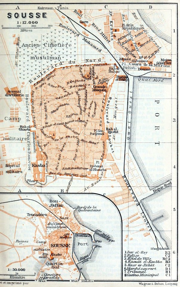
93 M. Susa.—The Station (Pl. B, C, 1) for Tunis, Kairwan (R. 58), Mehdia (p. 369), and for the future line to Sfax (R. 59), is in Boul. René Millet, 3–5 min. from the hotels, or 6 min. from the quay.
Arrival by Sea (comp. R. 64). The steamers of the Comp. Gén. Transatlantique (office, Banque de Tunisie, see below), the Società Nazionale (agent, Rue Villedon), and the Comp. de Navigation Mixte (Rue Jules-Ferry 4) all moor at the N. quay (Pl. D, 2). Harbour-tax 4 or 3 fr.—Cabs, see below.
Hotels (comp. p. 324). Grand-Hôtel (Pl. a; D, 2), Cours de la Marine, R. 4–7, B. 1½, déj. 3½, D. 4, pens. 11–15 fr.; Hôtel de France (Pl. b; C, 1), Avenue Krantz, R. 3–6, B. 1, déj. 3, D. 3–3½, pens. 10–12 fr., well spoken of; Hôtel du Sahel (Pl. c; D, 1), Rue Jules-Ferry, unpretending.
Cafés. Brasserie, at the Grand-Hôtel; Glacier, Place Pichon; Bellevue, Place de la Marine.—Casino Municipal (Pl. 8; C, 1), with a hall for balls and theatrical performances, etc.
Post & Telegraph Office (Pl. C, 2), Place Pichon.—Banks (comp. p. 174). Comp. Algérienne, Rond-Point de la Douane; Banque de Tunisie, Rue du Marché; Crédit Foncier et Agricole d’Algérie, Place Colonel Vincent.—Booksellers. Petit, Place Pichon; Berra (Imprimerie Rapide), Rue Jules-Ferry.
British Vice-Consul, W. Galea, Rue Général-Logerot (cor. of Rue de l’Eglise).—Lloyd’s Agent, D. Cattan.
Cabs (stand, Place Pichon). Drive ¾ (outside town 1) fr.; hour 1¾ (or 2), day 15–20 fr.; after 7 (in summer 9) p.m. one-half more.—Motor Cars at Auvin’s, Ave. Krantz.
Half-Day. Visit to the Museum (p. 367), the Souks (p. 368), and the Kasba (p. 369).
Susa, French Sousse, Arabic Sûssa, (pop. 25,000, incl. 2800 Italians, 1500 French, and 900 Maltese), which has been since ancient times the chief seaport in the Gulf of Hammamet (p. 364), is now the most important in Tunisia after Tunis and Sfax. It is also the capital of the Sahel (p. 320). This coast-region, 20–25 M. in breadth, famed in the Roman age for its olive-oil, yields corn also, like the inland plain of Kairwan, although its rainfall is slight. According to the latest statistics the Sahel has 6 million olive-trees, 212,000 acres of barley, and about 4000 date-palms, which here, however, mostly yield date-wine (‘lagmi’) only. As yet the manufacturing industries are practically limited to the oil-mills and soap-works in the suburbs close to the sea; there are also several salt-works on the coast between Susa and Mehdia.
367Susa, the Roman Hadrumetum, is one of the oldest Phœnician colonies on the coast of Tunisia. It appears for the first time in history at the end of the second Punic war, when it was Hannibal’s base of operations, and, after the battle of Zama (B. C. 202), his place of refuge. It escaped the fate of Carthage in 146 B. C., and it was again spared a century later, although it had sided with Pompey in the civil war. Under the later Roman empire Hadrumetum was remarkably prosperous, being the great outlet for the produce of the numerous and thickly peopled inland colonies as far as Tebessa. The fertility of its environs is indicated by the name given to it when re-colonized under Trajan (Colonia Concordia Ulpia Trajana Frugifera Hadrumentina). At that period the whole coast from Hadrumetum to El-Alia and Chebba (p. 370) was bordered with sumptuous country-houses. After its conquest by the Arabs (in 665, and again in 689) Susa, whose present name is said to date from the 8th cent., was outstripped by Kairwan and Mehdia. It afterwards suffered severely from the irruption of the Hilalides (p. 323) and its conquest by the Normans (1135), and in more modern times from its bombardment by the Spaniards (1537 and 1550), the French (1769), and the Venetians (1783).
The Harbour, 35 acres in area, constructed in 1886–9, is tolerably sheltered by two moles and by the Grande Jetée (737 yds.), the end of which is a splendid point of view. The Digue Sud (Pl. D, 4, 5), where new harbour-works are in progress, is occupied by storehouses for the phosphates from Aïn-Moularès (p. 372).
Between the N. mole and the dunes of Bou-Jaffar, near the Punic-Roman harbour (Kothon), of which scarcely a trace is left, lies the new town, dating from 1881. The busy parts of it are the Rond-Point de la Douane (Pl. D, 2), near the steamboat-quay, and the Place Pichon (Pl. C, D, 2), from which the Boul. René Millet leads to the station.
Between the two small public gardens here is the *Museum (Pl. C, 2), a valuable collection of Punic, Roman, and early-Christian antiquities, mostly excavated of late in the Sahel. Adm. daily, except Mon., 8–11 and 2–4 (from 1st July to 15th Oct. 7–11 only). No catalogue. Curator, M. E. Gouvet, the town architect.
The chief treasures of the museum are the numerous mosaics from Roman villas. In the centre of the hall is a large pavement from El-Alia, already freely restored in ancient times, representing an inundation of the Nile, with two-storied houses, a hippopotamus, a crocodile, etc.; by the entrance-wall, Neptune in a chariot with sea-horses, ducks, and fish; by the back-wall, procession of Bacchus, fishing scenes, a gazelle among edible animals and fruits (from a dining-room), the rape of Ganymede, a Nile scene, a basket with fish and lobsters; by the end-wall to the left, a peacock. By the right end-wall, an early-Christian mosaic, with the signature of the artist (Theodulos).
By the back-wall are relics of wall-paintings and the marble statuette of a negro boy. By the entrance-wall, fragments of Roman reliefs in stucco: head of a bearded man, from El-Djem (2nd cent. A. D.); bust 368of Athena and female head in profile, from Susa (2nd cent.). By the left end-wall, a large relief, from Susa, of the triumphal procession of a Roman emperor, with a fettered warrior behind the chariot.
The central presses contain (on the left) *Terracotta Figures from Susa (mother and child, Venus, female harpist, rider on a camel, etc.) and fine vessels in clay; (on the right) ancient coins; a fine bust in bronze and leaden rolls inscribed with curses (comp. p. 341), from Susa; bronze utensils, trinkets, implements in bone; Punic, Roman, and early-Christian lamps; mosaic of Virgil writing the Æneid.
The old town, an irregular quadrilateral almost unspoiled by modern improvements, contains no buildings of outstanding importance, but its Oriental streets are strikingly picturesque. The many-towered *Town Wall, with its gallery of defence and its crowning battlements, was erected by the Aglabides (p. 323) in 827.
From the Place Pichon we first visit the Place Bab el-Bahar (Pl. C, 2), named after the old ‘sea-gate’, almost always enlivened by a dense and busy throng. The main streets of this quarter are the Rue de France and Rue Général-Logerot, between which rises the Chief Mosque (Pl. C, 2), built in the Aglabide period on a ⟙-shaped plan (p. 376), with forecourts like the Gâmia Ibn Tulûn at Cairo (p. 451).
In the secluded streets to the N.W. of the chief mosque, which are best reached from the Hôtel de Ville (Pl. 3, B, C, 2; new building in course of construction in the Ave. Mougeot, in front of the harbour) by the Rue Général-Riu and Rue du Kasr, rises the so-called Kasr er-Ribât (Pl. 5, C, 2; ‘castle-convent’), originally a Byzantine fortress, but used since the Aglabide period as a fortified monastery (Kasr al-Morabitîn, castle of the marabouts) for defenders of the faith against the infidels. It is now a humble medersa (p. 228). The building, modernized in the Turkish period, was originally square, with four round corner-towers and four at the sides. The domed vestibule contains fragments of the Byzantine edifice. In the interior (no admittance) there is a small mosque.
The Rue Général-Sabatier on the W. side of the chief mosque, and the Rue de Paris, its continuation to the S., lead to the Rue el-Mar (Pl. B, 3, 4). Here, at the corner of the Rue de la Kasba (p. 369), rises a fine Minaret. At the end of the street is an interesting old Dwelling House, thoroughly restored in 1906, with horseshoe and multifoil arches.
In the Rue de la Soffra (Pl. B, 3), above the Rue el-Mar, are the Roman Cisterns, which have been repeatedly restored since the middle ages (keys at the town architect’s; see p. 367).
To the W. of the Rue de Paris are the picturesque Souks (p. 335). Immediately to the right, adjoining the Souk el-Rbâ (Pl. B, 3), the vaulted lane in the middle, and at the entrance to the Rue Bin el-Kaoui, is the Kahwât el-Kubba (Pl. 4, B, 3; ‘domed café’), a small early-Moorish building with an interesting dome, four wall-niches, and windows partly built up.
369The Souk el-Caïd, continuing the Souk el-Rbâ, ascends to the Bâb el-Gharbi (Pl. A, 3), the old Moorish W. gate.—In the Rue Dâr el-Bey, between the Souk el-Caïd and Rue de la Kasba, is the Dâr el-Bey (Pl. 1; B, 3), an old palace of the beys of Tunis, now the Contrôle Civil and office of the caïd (driba).
The Rue de la Kasba, or from Bâb el-Gharbi the boulevard outside the town, leads to the Kasba (Pl. A, B, 4; 131 ft. above the sea), the Moorish-Turkish citadel, built partly on the foundations of a Roman temple, now the barracks of the tirailleurs (adm. on presenting visiting-card; a sergeant acts as guide). The ‘Salle d’Honneur’ contains neo-Punic and Roman antiquities from the Camp Militaire (see below), including valuable mosaics (victorious racehorses, etc.) and early-Christian objects from the catacombs (see below). From the N. terrace of the Kasba, or from the tower (now lighthouse; not always open), there is a splendid *View of the town and harbour, of the Sahel, the whole bay of Hammamet, and of the inland Tunisian hill-country as far as Jebel Zaghouan.
From the Bâb el-Gharbi a road leads to the W. to Kalaâ-Srira (p. 366) through the Camp Militaire (Pl. A, 3, 4), whose huts stand partly on the ancient Punic burial-grounds. About ¾ M. from the gate are remains of a Roman Burial Ground; also, on a road diverging to the left a little before, extensive early-Christian Catacombs (adm. 1 fr.), 3 min. to the S. of the highroad.
From Susa to Mehdia, 39½ M., railway in 3¼ hrs. (7 fr. 5, 5 fr. 35, 3 fr. 80 c.). The line runs, a little apart from the Sfax road (R. 59), at first to the S.W., through the beautiful hill-country of the Sahel, to (6 M.) M’Saken (p. 378). 11 M. Ouardenine, where the new line to Sfax (see p. 378) diverges to the S. Our line sweeps round to the E. to (16 M.) Djemmal.—22 M. Moknine (181 ft.; Café-Restaurant de la Gare; pop. 9000, incl. 700 Jews and 70 Europeans) is noted for its Jewish goldsmiths’ work in an antique style like that of Djerba (p. 394). On the road to Monastir (p. 405), 3¾ M. to the N.W. of Moknine, are the ruins of the very ancient Phœnician-Roman seaport Leptis Minor, now Lamta or Lempta (remains of the old quays, cisterns, etc.), near which is the Punic necropolis Henchir Meskhal.
The train skirts the Sebkha de Moknine. 27½ M. Teboulba (146 ft.; pop. 2900), a small town amidst pretty orange and mandarin gardens, on the S. shore of the Bay of Monastir (p. 405). Farther to the S.E. we come to (30 M.) Bekalta (pop. 3400), a little town with the ruins of the seaport of Thapsus, famed for Cæsar’s victory (p. 322; large Roman cisterns, amphitheatre, quay of the Punic-Roman Kothon, Punic rock-tombs).
39½ M. Mehdia or Mahdia (66 ft.; Hôt. de France, Grand-Hôtel, both very humble; Brit. cons. agent, G. Violante; pop. 10,000, incl. 600 Europeans), the ancient capital of Ifrikia (p. 322), founded in 916 as Mahedia by the Fatimite Obeïd Allah el-Mahdi, on the site of the Phœnician-Roman Zella (Africa?), is now a poor little seaport-town with hardly a trace of its former renown. Being centrally situated on the E. coast of Tunisia, on the narrow and once strongly fortified headland Râs Mehdia, the Cape Africa of earlier writers, Mehdia, after the destruction of Kairwan (p. 372), developed into the most prosperous town and important harbour of Tunisia, but suffered severely from the transference of the seat of government to Tunis (p. 332). In war also it was often sorely tried. It was conquered by a Pisan fleet in 1087, occupied by the Normans in 1148–60, and captured by the knights of Malta in 1530, by Kheireddin’s (p. 221) former 370general Dragut in 1540, and in 1550 by the Spaniards, who on their retreat after the naval battle of Djerba (p. 394) blew up its fortifications.
The chief sights are the picturesque ruins of the Town Walls and the Grande Mosquée of the 10th cent., formerly connected with a college, with its many arcades and a fine gateway-tower, resembling the Bâb Lella Rejana at Kairwan (p. 375). To the S.E. of the headland are remains of the Kothon, the Punic-Roman harbour, which in the middle ages was defended by two towers. The new harbour, the centre of the Sicilian allache (kind of sardine) fishery, lies to the S.W. of the headland. Near the town are large Salt Marshes. The Necropolis, 2 M. to the W., with several well-preserved Punic and neo-Punic rock-tombs, deserves a visit. About 1 M. from the town are extensive early-Christian Catacombs (adm. 1 fr.).—Off Mehdia, in an ancient sunken ship, beautiful works of art, now at the Bardo Museum (see p. 344), have been recently discovered.
A road (carr. 15 fr.) leads to the S.W. from Mehdia viâ (8 M.) Ksour-Essaf to (26 M.) El-Djem (p. 379).
In the olive-clad hill-country to the S. of Mehdia, on the road to Sfax (p. 380), lie the ruins of the ancient seaport of Sullectum (now Salakta), of Acholla (p. 398; now Biar el-Alia), both with Punic burial-grounds, and of Uzalis (now El-Alia). Farther on, beyond the Râs Kapoudia (or Râs Khadidja), the ancient Caput Vada, where Belisarius (p. 322) landed in 533, lies the small seaport of Chebba, noted like El-Alia for its Roman mosaics. Near it are the ruins of Ruspae (now Henchir Sbia).
From Susa to Kairwan, see R. 58; to the ruins of central Tunisia and to Metlaoui, see R. 58; to El-Djem and Sfax, see R. 59.
58. From Susa to Kairwan.
36 M. Narrow Gauge Railway in 2¼–2½ hrs. (6 fr. 50, 4 fr. 95, 3 fr. 50 c.; return 9 fr. 10, 6 fr. 95, 4 fr. 90 c.). Passengers from Tunis (return-fares 30 fr. 25, 22 fr. 95, 16 fr. 25 c.) change at Kalaâ-Srira (Rail. Restaurant).
From Susa to (5 M.) Kalaâ-Srira, see p. 366. The line runs, nearly in the same direction as the Susa and Tebessa (p. 315) Roman road, to the S.W., on the right bank of the Oued Laya (p. 366), to the (8 M.) Réservoir of the Susa waterworks.
At (10 M.) Oued-Laya, a small oasis of fruit-trees and vegetables, the olive-zone of the Sahel ends. 17½ M. Kroussiah-Sahali. 23 M. Sidi el-Hani, not far from the ruins of Vicus Augusti (?).
To the left, farther on, we obtain a glimpse at the Sebkha Sidi el-Hani, 25 by 12½ M., the largest salt-lake of central Tunisia. To the right, a little farther on, beyond a chain of flat hills, is revealed a striking view of the vast Plain of Kairwan, enclosed by distant mountains, with the town of Kairwan in the background. The low ground, through which the Oued Hathob (p. 320), Oued Merguellil, and many smaller streams descend from the Sahara Atlas and its plateaux to the Lac de Kelbia (p. 320; not visible from the train), is often flooded after the winter rains. It is inhabited almost exclusively by the Arab-like nomadic tribes of the Djlass or Zlass. The train runs through plantations of Indian figs.
30½ M. Aïn-Ghrasesia.
From Aïn-Ghrasesia to Metlaoui, 182 M., railway in 13 hrs. (fares 32 fr. 85, 24 fr. 95, 17 fr. 55 c.; from Susa 38 fr. 35, 29 fr. 10, 20 fr. 37150 c.). This new railway, diverging here to the S.W., affords the easiest access to the ruins of Sbeïtla, Kasserine, Thelepte, and Feriana in central Tunisia. It runs over a low saddle between the Sebkha Sidi el-Hani (see p. 370) and the marshy plain of the Oued Hathob, and across the bleak plain of Kairwan, to the S.W. borders of the Sahara Atlas, which it reaches at the foot of Jebel Touila, with its zinc and lead mines.
47½ M. Hadjeb el-Aïoun, the ancient Masclianae, on the Oued Zourzour, is the chief market (Tues.) for the Oulad Sendassen, a branch of the Djlass tribe (p. 370), and, like the following stations, possesses an alfa-depot. Branch-line to Sbiba, the ancient Sufes, projected.
Farther on we pass the foot of Jebel Hadjeb el-Aïoun to (58½ M.) Djilma (1152 ft.), the Roman Cilma, on a tributary of the Hathob, here called Oued Djilma, We now enter, to the W., the valley of the Oued Menasseur, at the foot of Jebel Mrilah (4508 ft.) and Jebel Sbeïtla, inhabited by the Madjeur tribe (p. 362).
76 M. Sbeïtla (1762 ft.; hotel), near the extensive ruins of Sufetula, on a plateau on the right bank of the Oued Sbeïtla, as the Oued Menasseur is named here. It was a poor castellum in the time of Augustus, but after the 2nd cent, became one of the most important junctions of different routes, and in the 5–7th cent. attained its prime under the Vandals and the Byzantines. In 645 it became the residence of Gregory, the governor, who had rebelled against Byzantium; it was soon after attacked by the Arabs under Abdallah ibn Saâd (p. 322), and in 648 it was entirely destroyed. The chief boast of Sbeïtla is the *Capitol (comp. p. 288), rising in the midst of the ruins. The temple-court, once used by the Byzantines as a fortress and now destroyed save a few fragments of the limestone pavement, was entered by a three-arched propylæum, bearing an inscription in honour of Antoninus Pius (138–61). The chief temple was pseudo-peripteral, with composite columns; there are still traces of the steps up to it and of the portico. The three cellæ are well preserved, especially at the back, and have a transverse wall, instead of a semicircular apse, adjoining the Corinthian smaller temples. We may note also a fine Triumphal Arch of the time of Constantine, the remains of a Byzantine Church incorporated with a temple, to the N. of the capitol, a Chapel built into a smaller temple, to the E., and the Aqueduct across the Oued Sbeïtla. Higher up is the spring of the new water-conduit, 103 M. long, which supplies the town of Sfax.
Passing many other ruins we come to the Plaine du Foussana (about 2650 ft.), one of the upper districts of the Oued Hathob, here called Foussana, at the S. foot of Jebel Semmama (4307 ft.; with the zinc-mines of Aïn-Khamouda on its N. side). Then a descent to (95 M.) Kasserine (2382 ft.), the ancient Cillium, a flourishing town from the 2nd cent. A.D. under the name of Colonia Cillitana, now a poor village with a caravanserai on the Thala and Feriana road (see p. 362 and below), not far from the chalky limestone masses of Jebel Chambi (5217 ft.; p. 320). We may here visit the ruins of the Roman Arch and of the Tomb of the Petronii, and above all the interesting Mausoleum of T. Flavius Secundus, of the time of Trajan. This is a kind of tower in three stories, in the Phœnician fashion, terminating in a pyramid; the 110 bombastic lines of the inscription correspond with the number of years attained by the deceased. A little to the S., on the Oued Derb, are remains of a Roman Barrage,—The landscape farther on, where Roman ruins still abound, assumes more and more the Sahara character.
116 M. Thelepte (hotel) is the station for the ruins of the ancient town of that name, now called Medinet el-Khedima (‘the old town’), which in the 2nd–4th cent. A.D. was the chief place on the road between Tebessa (p. 315) and Gafsa (p. 383). Large thermæ, ruins of early-Christian basilicas, and a Byzantine fortress with many towers are to be seen here. The extensive Roman Quarries are interesting.
118½ M. Feriana (2628 ft.; Hôt. Hostelier; Restaurant Bernard; pop. 1200), an oasis of corn, fruit, and vegetables on the Oued Feriana, in 372the midst of a sandy plain, has a new and pretty mosque.—Thence we cross the Plateau de Msila (2930 ft.), overgrown with alfa, and descend to (134 M.) Maâjen Bel-Abbès, with the ruins of a Roman town, 28 M. to the N.W. of Gafsa. 141 M. Sidi Bou-Beker.
153½ M. Henchir Souatir (about 1640 ft.). A short branch-line diverges hence to Aïn-Moularès (1806 ft.), a caravanserai near the great beds of phosphate on the Algerian frontier.
166 M. Tabeditt is connected by railway with (9½ M.) Redeyef, which has rich phosphate deposits.—Beyond Tabeditt the train runs through the valley of the Oued Seldja (p. 386), here inhabited by the Oulad Sidi-Abid nomads, to (183 M.) Metlaoui (p. 386).
The Kairwan Line runs to the W. over the bleak steppe, often passing the tents and the browsing camels and cattle of the Djlass (p. 370). We cross the Oued Hathob, here called Zeroud.
To the right, especially in the afternoon, we have a delightful *View of the white houses of Kairwan, with its countless domes and towering minarets. Nearing the station we see extensive fields of cactus and large alfa-stacks.
36 M. Kairwan.—Hotels (comp. p. 324). Splendid Hotel (Pl. a; C, 5), R. 3, B. 1, déj. or D. 3, omn. ½ fr.; Hôt. de France (Pl. b; C, 5), R. 2½–4, B. ¾, déj. or D. 3, pens. 7½ fr.; both in the Place Carnot, tolerable.—Café de France, Rue Massicault.—Post & Telegraph Office (Pl. C, D, 4), Rue de la Poste.—Physician. Dr. Santschi (a Swiss), Grande Rue, near the Bâb Djelladin.
In Half-a-Day, if pressed for time, we may visit the Grande Rue, the Souks, the Sidi Okba Mosque, and the Mosquée du Barbier. Tickets for the mosques are obtained at the office of the Contrôle Civil (p. 373) or at the hotels. The overseers of the mosques mostly speak Arabic only. The guides, who are quite unnecessary, are very importunate.
Travellers in haste should endeavour to secure a cab (as yet only one), drive to the Contrôle Civil, the Barber’s Mosque, and back to the Porte de Tunis (p. 377), and there begin their inspection of the town.
Kairwan or Kairouan (243 ft.; pop. 22,000, incl. about 800 Europeans), the oldest capital of Ifrikia, is a town of purely Arabian type, the most curious in Tunisia. The old town is an irregular rectangle, enclosed by a wall 33 ft. high and 2 M. in length; the large W. suburb, also purely Oriental, is the Faubourg des Djlass, called after the nomadic tribe of that name (p. 370); to the S. is a new suburb near the station. The numerous mosques and zaouïas date mostly from the Turkish period. The town holds market for the extensive plain of Kairwan, and the souks are still important, though manufactures have declined. The climate (p. 321) is extremely hot in summer.
Kairwan was founded by Sidi Okba ben-Nâfi (p. 322) in 671, and was appointed by the caliphs to be the seat of the governors of Ifrikia. As the capital of the great Aglabide empire (p. 323) and the seat of the oldest high school in N. Africa, it was hardly less important than Cordova (p. 68), and the sumptuous mosque of Sidi Okba rapidly became the favourite goal of pilgrims from E. Barbary. After the Hilalides (p. 323) had destroyed the greater part of the town in 1048 it was for centuries almost deserted, notwithstanding the favour shown to it by Abd el-Mûmen (p. 95), the Hafsides, and the Merinides (p. 95). In the early 16th cent. several quarters still lay in ruins. It was not till the Turkish period that the sacred town, ‘one of the four gates of Paradise’, which neither Christian nor Jew durst enter, again became the religious centre of the land. To spend one’s last days within its walls, and to be buried in hallowed earth outside its gates, seemed to believers the height of bliss. Its sacred character, which however did not prevent the beys of Tunis from bombarding and partly destroying the rebellious town, was finally lost when the mosques were desecrated by the entry of the French troops in 1881.
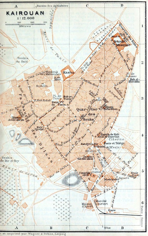
373In the centre of the S. suburb, almost exclusively inhabited by Europeans, is the Place Carnot (Pl. C, 5), with its small Jardin Public. On its W. side the Rue du Contrôle, with the building of the Contrôle Civil (Pl. C, 5; see p. 372), leads to the N. to the Place Mérabet (Pl. C, 4) and the S. gate of the town-walls, which were largely rebuilt after the bombardment of 1740.
On emerging from the Rue du Contrôle we see immediately to the left the Zaouïa Sidi ben-Aïssa (Pl. C, 5), where the hideous castigations of the Aïssaoua sect, originally Moroccan, are held on Friday afternoons. A little to the N.E., in the Rue de la Poste, is the M’sala Darb et-Tamar (Pl. D, 4; no admittance), a large open place of prayer for great Mohammedan festivals, with an underground cistern for rain-water.
The main street of the old town, between the Bâb Djelladin (Pl. C, 4; ‘Porte des Peaussiers’), or S. gate, now partly demolished, and the N. gate, the Porte de Tunis (p. 377), is the Grande Rue (Pl. C, B, 4, 3), officially called Rue du Général-Saussier, enlivened by a picturesque crowd and numerous small shops.
In the Rue Sidi el-Guerian, the second side-street on the right, is the zaouïa of Sidi Abid el-Guerian (Pl. C, 4), an elegant building of the Turkish period (16th cent.?). The handsome portal, with the black and white striped decoration so often recurring in the other buildings, leads into a vestibule with tiled walls and stucco decoration, beyond which are a fine colonnaded court in two stories (with the sumptuous tomb of the saint on the left) and a small mosque. Adjacent on the left is the court of the Medersa (p. 228), where the capitals of the columns are remarkable for their richness and variety.
Farther on in the Grande Rue are several mosques of little architectural interest. The gateway on the right, halfway between the two town-gates, leads to the Souks (Pl. C, 3, 4). The vaulted main street here, the Souk des Selliers and Souk des Cordonniers, is intersected by two vaulted side-streets, the Souk des Parfums and Souk des Tapis. The latter, for the sale of carpets, woollen rugs (margums), etc., has declined since the vegetable dyes have been superseded by the aniline. The farther part of the main street is the Souk des Gandourahs, ending at the quiet Place Finot (Pl. C, 3).
To the S.E. from the Place Finot the short Rue Moulei-Taïeb leads to the—
Djamâa Tleta Biban (Pl. C, D, 3; Mosquée des Trois-Portes), in the Rue Hassin Lalenni. It dates from the time of Obeïd Allah el-Mahdi (p. 369), being the only early-Moorish building in Kairwan besides the Sidi Okba mosque, but was much altered in 1440 and 1509. The peculiar façade in three sections, with blind arcades 374(possessing Byzantine capitals) on the lower story, is composed above of older slabs with geometrical ornamentation. The interior is uninteresting.
We follow the Rue de la Mosquée des Trois-Portes to the N.E., then the Rue Zoughar to the right, and at the end of it a street to the left to the town-wall. To the left, in 2 min. more, we reach the Place de Sousse, with the Bâb el-Khoukha (Pl. D, 2, 3), the E. town-gate, an interesting double gateway, with two fine Byzantine capitals on the inner archway. From the N. end of the Place de Sousse the broad Rue de la Grande-Mosquée leads to the—
*Sidi Okba Mosque (Grande Mosquée; Pl. D, 1, 2), one of the oldest in the world, and, next to the Kairwin mosque at Fez, the most important in Barbary. After the mosques of Mecca and Medina and the Dome of the Rock at Jerusalem (p. 477), this has ever been deemed the greatest sanctuary of Islam. The poverty of the oldest building, founded by Sidi Okba ben-Nâfi in 671, is evidenced by the mud-built walls of the old mihrâb (p. 377). A new building was first erected in 703 by Hassan ibn en-Nôman (p. 322), the conqueror of Carthage. The plan seems to have been suggested by that of the oldest Egyptian mosques (such as the mosque of Amru, p. 460), combined with that of the Damous el-Karita (p. 349), while the ruins of Carthage, Susa, and Sbeïtla (p. 371) supplied the building-materials. Of a second new building by the governor Bichr ibn Safuan, in 724, the fortress-like lower story of the minaret still exists. A further extension was made in 821 by the Aglabide Sijadet Allah I. The central story of the minaret, the arcades of the quadrangle, the Bâb el-Behou (p. 376), and the last enlargement of the sanctuary itself are due to the Aglabide Ibrahim ibn-Ahmed (d. 875), who erected also the fine dome of the mihrâb, caused the mihrâb-wall to be decorated by Bagdad artists, and presented the superb Friday pulpit. The present maksûra (seat of the caliph) dates from the time of the Zirite Abû Teminn el-Muizz (p. 443). The decay of the mosque after the irruption of the Hilalides seems to have been first arrested by Abd el-Mûmen and the Hafside El-Mostanser Billah (p. 332). The latter, in 1284, caused most of the outer gateways to be rebuilt. At a later period we hear of restorations by Mohammed Murad Bey (p. 335) and Hussein Ali ben-Turki (p. 323). In 1828–42 the insecure state of the mosque necessitated the rebuilding of the external walls on the N.W. and N.E. sides and the restoration of the minaret, the Bâb el-Behou, and the arcades of the court. In 1872 the nave and its two adjoining aisles also were restored, but with little taste, and since 1895 the French government has bestowed its attention on the transept and the side-portals.
The immense edifice, an irregular quadrilateral of 136 by about 78–82 yds., covers an area of over 2¼ acres. The fortress-like 375Outer Wall, with its huge buttresses, has four doors on both its longer sides. These have lost their bronze mountings and some of them their cupolas. Above the S.E. wall rises the dome of the mihrâb chapel and above the N.W. wall the minaret.
We first walk round the whole enclosure. From the Rue de la Grande-Mosquée a short street leads to the right, past the new Court of Ablution (comp. p. 63), to a large open space adjoining the S.E. end of the mosque, where there are numerous underground silos or granaries. From the walls here project the buildings of the mihrâb chapel and the maksûra, with the Bâb el-Imâm (p. 377).
A few paces farther, at the beginning of the ‘Boulevard Ali Bey’, a poor street on the N.E. side of the precincts, is the massive square gateway tower of *Bâb Lella Rejana, adjoined by the insignificant domed tomb of that saint. The front half of the gateway, restored in 1828, is painted like the minaret with ‘giant-spiders’ to ward off snakes and scorpions, and is adorned below the battlements with blind horseshoe arcades. The perforated stucco decoration of the arch-recesses of the side-portals is one of the earliest examples of such work. The long inscription over the door extols caliph El-Mostanser-Billah (p. 374), the builder.
Passing the next three gates we come to the N. angle of the precincts, where their fortress-like character is most apparent. Beside the embrasures of the minaret (p. 376) are seen cannon-ball marks made during the bombardments of the 18th century.
The S.W. wall of the mosque, in the Rue de la Grande-Mosquée, which we now regain, is most in conformity with the original plan. Most noteworthy here are the first gateway-tower, near the N.W. angle, and the Bâb es-Sultân, the last gate, through which led the shortest way from the caliph’s palace to the maksûra (comp. p. 377). The domes, now adorned with the Turkish crescent, still possess their girdle of battlements and have their old cornice of bricks placed crosswise.
The present Entrance Gateway (visitors knock) is one of the small middle gates beside the Bâb es-Sultân. We descend a few steps to the court (now below the level of the street), where the irregular plan of the building is most distinctly seen.
The *Court is bordered on the N.W. side by a single colonnade and on the other sides by double arcades, which on the S.E. side form the porch of the sanctuary. In contrast to the orange-court at Cordova (p. 70), it is much larger than the sanctuary itself. The marble pavement is modern. The perforated stone in the centre of the court conducts the rain-water from the gutters on the flat roofs into a filtering-apparatus and into three Cisterns below. The old Court of Ablution (Ancienne Mida; comp. above), near the W. angle, and the rooms adjoining the minaret are now used as lumber-rooms.
376The Minaret, 128 ft. high, an extremely massive tower in three stories, rises in the centre of the N.W. wall, and not in the central axis of the building as is usual. The substructures have been built of Roman stones and the doorway framed with antique decorative slabs. The square lowest story and narrower middle story are crowned with peculiar battlements with small embrasures. Above the three metal balls (p. 195) of the present dome is perched the Turkish crescent.
The *Ascent of the Minaret (127 easy steps) should not be omitted. On the lower platform we note the muezzin’s hut (p. 180). The upper platform commands a superb survey of the many-domed town, of the Barber’s Mosque (p. 378), of the large cemeteries to the W., and of the great plain of Kairwan, bounded by Jebel Trozza and other distant hills.