III FIRST WESTERN EXPEDITION
Reading edition
January–March, 1911
113
FIRST WESTERN EXPEDITION
On the 24th of January the ponies went over the sea-ice to Glacier Tongue en route for the Barrier Depôt trip. Captain Scott and the western party sailed in the Terra Nova to the Tongue, which we reached about noon.
Later we were able to study the Tongue in some detail, but we could see that it consisted of a huge pier of ice about half a mile wide, and projecting some five miles from the low cliffs south of Turk’s Head. The surface was undulating, and about a hundred feet above the sea in the centre. Its origin is doubtful. Probably it is old piedmont ice anchored on some hidden ridge, but it is added to by blizzards sweeping over the root of the Castle Rock Promontory and depositing snow on the leeward side of the cape. We saw sections of it stranded fifty miles to the north-west later, which proved its partial origin from snowdrifts.
On the 25th Debenham, Wright, and myself marched to Hut Point, where the 1902 hut was situated. We took a light sledge and our sleeping-bags. It was very interesting to recognize the places of which we had read in the “Voyage of the Discovery.” Castle Rock was very prominent, a huge dark square “keep” about two hundred feet above the promontory; “Danger Slope”—an icy slope dropping down to 150 feet ice cliffs—on which Vince lost his life early in 1903. The conical hill, seven hundred feet high, just east of Vince’s Cross, was Observation Hill; destined to carry another cross two years later to the memory of the man who had built the hut below.
Off Hut Point the sea-ice was very rotten and full of huge holes. However, we reached the ice-foot easily enough, and pulled up to the hut. The surroundings were very tidy compared to Shackleton’s quarters, which was very natural, for the 1902 expedition practically lived in the ship. It was 114surrounded by tremendous eaves, which were meant to protect stores, etc. We found the door blocked by ice, and had to enter by a window. It was filled with snow to a depth of four feet, which had drifted in through various openings. We found a bulwark of biscuit boxes in the middle, and various stores of chocolate, etc. Some brownish powder, after some cogitation, we determined to be pepper. It had quite “lost its savour” in the ten years of exposure. Alongside were the little magnetic huts. Wright commandeered some asbestos sheets for our own magnetic equipment, and then we set off to see the real object of our visit.
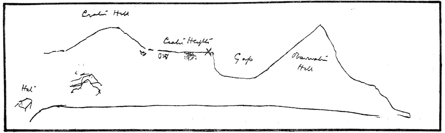
Original geological sketch by Captain Scott (January 19, 1911), directing our attention to an unusual outcrop at Hut Point.
Captain Scott had noticed an exposure of lamellar rocks of a sandy appearance among the almost uniformly dark basic rocks of this region, and, although no geologist, he realized that it was possible that a fragment of the well-known Beacon Sandstone (a fossil-bearing rock) had been torn up by a basic lava on its passage to the 115surface. This would show the relative age of the two rocks concerned (the lava, of course, being younger), and so was well worth investigating. We found the outcrop readily enough from Captain Scott’s sketch, but Debenham and I decided that it was a weathered variety of eruptive rock, and not of sedimentary origin.
Two other appearances were noticeable here, which were worth recording because we saw them later in various other quarters of Victoria Land. We could not account for them from our first example. On the steep face of the cliff (five hundred feet high) near where poor Vince slipped to his doom, were four long horizontal ridges—one above the other—of dark masses of rock. They resembled lateral moraines left by giant glaciers, but I believe they are due to debris rolling down to the foot of a snow slope. The latter varies in extent with varying seasons, and so the debris ridge may be deposited at another level.
Another very curious feature soon attracted our notice. All the more or less level lowland around Cape Armitage, as well as the bare plateau of Crater Heights, was marked out like a gigantic tesselated pavement. I noted in my journal, “The lowlands of loose black rock appear to be rolled by a steam roller, while the surface is broken by gutters from four to eight inches deep.” These gutters marked out hexagonal and polygonal areas some twenty or thirty feet across. When a light snowfall had collected in the gutters, the valleys seemed to have been paved with black tiles united by white mortar.
These symmetrical polygons are due to a slow movement of half-frozen soil, which has been noted in polar lands, and is called solifluxion or soil-creep. We saw many examples of these tesselations in the western moraines.
We walked back to the camp on the sea-ice, pulling the asbestos sheets on the sledge. There was some cold tea to spare in Nelson’s tent, and we were glad to make our meal off this and some biscuits. Then, pillowing my head on a camera, I coiled into my sleeping-bag, and so spent my first night on trek.
On the next morning we were told that we could ride back to the ship on the dog sledges. Nothing loth, we tied our sledge behind Meares’, and soon covered the eight miles.
The dogs pulled rapidly, but seemed to need frequent 116rests. It was much more lively than “man-hauling.” Meares’ constant cries, “Tchui—Tchui! Ky—Ky!” directed the leading dog, and the six pairs behind him swerved left or right in unison. There were numerous seals on our route, and Meares had considerable trouble to keep the dogs to the straight path of duty. One ginger seal especially excited their interest, and ours also, for the colour is most uncommon. Usually the seals are a dull fawn brown, though the breast is often beautifully mottled with white spots.
My first seal-killing had been done a day or two before.
After dinner Wright and I had marched off on hunting bent. We walked over the great South Road—where we had cleared a track for the ponies over Cape Evans—and reached Gully Bay. Just over the tide crack we came on three seals; one beautifully dappled, one small and dark, and a huge, big fellow. We wanted the skin for making sandals, and so attacked the biggest specimen. There was not much attack about it! You just hit him hard on the nose, as Wright did with an ice-axe, and then stab him under the fore-flipper, as I did with my Serbish dagger. To make sure, we pole-axed him also. Then we skinned him with considerable difficulty, for two of us could hardly make the body budge! The skin and blubber were two inches thick and frightfully slippery; you could not grip it. We had to drive the ice-axe into the loose flap of hide, and so gradually drag the carcase into the positions necessary for flaying. We left the hide on the head and limbs, and then cut through the cartilaginous breastbone and secured the huge liver—about forty pounds of it, I expect. We intended to drag the hide back with a rope, but all we could manage was the liver, of which I hung a part on each forefinger. Then we walked back to the hut, about half an hour’s journey, and when we arrived I gave the liver to the cook. I soon found that my fingers were frostbitten, and through inexperience I stayed in the hut. For five minutes I tramped up and down with an almost unbearable pain in my fingers very like toothache. Never again did I expose my hands in the Antarctic in any constrained position, so that this first slight mishap was a good lesson to me.
On the 27th of January the ship left Glacier Tongue, to carry our party to the western side of MacMurdo Sound, a 117distance of thirty miles. I got a photo of the face of the Tongue—showing queer little bulbous icicles where the swell of the tide had licked them. The Tongue rises and falls with the tide, and so there was no very definite crack between it and the sea-ice at its end. Little did we think that this century-old natural wharf was to be torn away from its moorings a few weeks later!
Now that all chance of adding to our equipment had passed, we found that several important matters required attention. For instance, my ski-boots—in which I had to traverse rocky slopes for six weeks—developed a hole thus early in the campaign! This apparently trivial matter bulked very largely in the succeeding journey, and though they were roughly cobbled on board and stiffened with all sorts and conditions of nails—none being very suitable—they were a constant source of worry.
In the afternoon we approached Butter Point, passing through a belt of “brash ice” to reach it. This curiously named headland is where the 1902 party started to explore the western valleys. Here a supply of butter was left for the returning travellers to reward them with a toothsome dish of fried seal’s liver (if they had “first caught their seal”).
Butter Point is really the north-east end of a “piedmont” glacier. It is a mass of ice—almost stagnant—which covers a coastal shelf some five miles wide between the foothills and the sea. The snow slopes rose rapidly to a hundred feet or so, and then more gradually to five hundred feet. Many unsuccessful attempts to fix an ice-anchor in the hard snow (covering the glacier) resulted in our moving north a short distance, where a grip was obtained when the anchors were carried some two hundred yards inshore.
On the summit of the snow ridge, about half a mile away, we saw the pole of the depôt left by the 1907 expedition. This was now visited by a sledge party to depôt provisions for the forthcoming northern journey in spring.
In the meantime our two sledges were lowered on to the ice, and packed in readiness for our start. The sledges differed in size, one being twelve feet long, and the other only nine feet. The latter Evans evidently regarded as the apple of his eye, but weight for weight it was much less efficient than the 118larger sledge, since it weighed almost as much, but could not carry three-quarters of the load. We had a heavy equipment for four men, averaging about 270 lbs. each, but as we were only proposing to take one sledge for a considerable portion of the journey, this was of little importance.
Our total load was as follows:—
LBS.
Sledges, etc. Twelve-feet sledge 52
Nine-feet sledge 47
Two instrument boxes 14
Iron under-runners 52
Total 165
Food and Fuel, etc. Oil tins on platform 78
One tin of spirits 5½
Seven weeks’ food 250
Biscuits (four boxes) 196
Ready bag (one week) 41
Boxes protecting biscuit 52
Cooker 7½
Total 630
Tools, etc. Three ice-axes ... 8½
Crowbar and shovel 14
Candles 3
Lantern 1½
Alpine rope 11
Bamboos 2¼
Tent and poles 26
Four sleeping-bags 49
Repair bag, etc. 14
Total 130
Instruments, etc. Theodolite 11½
Aneroids, etc. 1
Zeiss camera 8
Six dozen plates 12
Goerz camera 7
Three dozen plates 6
Box camera and films 7
Polariscope 5
Binoculars 3
Compass, abney, etc. 5
Total 65
119Personal Gear 50
LBS.
Totals Sledges, etc. 165
Food, etc. 630
Tools, etc. 130
Instruments, etc. 65
Personal 50
1040
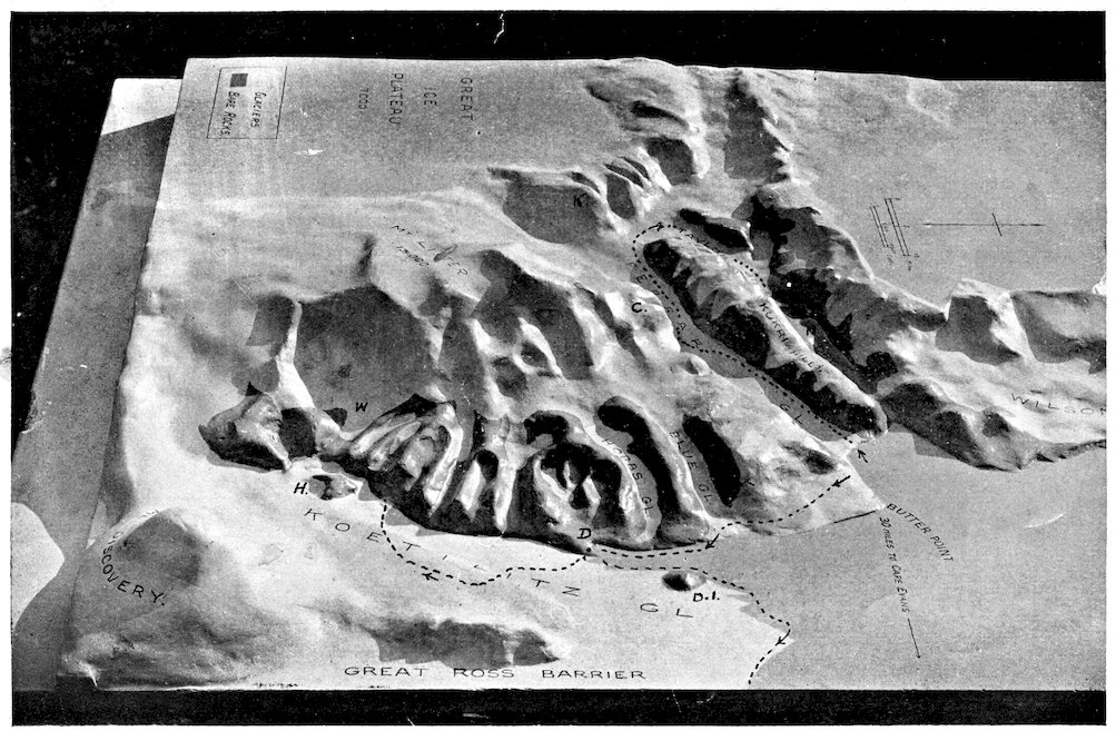
MODEL OF COUNTRY TRAVERSED ON FIRST JOURNEY. Outward journeys, Butler Point to Alcove Camp and Butler Point to Heald Island, shown. See also folding map at end of book. C = Cathedral Rocks. D.I. = West Dailey Island. K = Knob Head. D = Davis Bay Depôt. H = Heald Island. N = Nussbaum Riegel. W = Walcott Glacier.
Several items in this list may be commented on. The heavy steel sledge runners were designed to fit under the wooden runners of the sledge, to take the wear and tear when we were crossing the rough ice of the glaciers. No favourable occasion for their use arose until half our journey was completed, and then, as will be seen, the trial resulted in the smashing of the large sledge. We also carried the biscuit tins enclosed in their stout wooden cases up and down the Ferrar glacier, with the idea of preserving the biscuits from breakage. The cases were discarded on our return to Butter Point without any inconvenience from broken biscuit resulting. These two items alone constituted one-tenth of our load, and we were glad when trials showed that we could get along much better without them.
It will be noticed that an exceptionally large photographic battery was carried. This was necessitated by the character of the problems which engaged our attention. For instance, Wright was chiefly interested in the forms of ice structure which we encountered. The most delicate ice-crystals, which withered at a breath, must needs be photographed in situ. There was no possibility of his bringing back specimens for study in the hut during the dark winter months. For similar reasons a somewhat bulky polariscope—in which sheets of ice were examined in polarized light—formed part of Wright’s load, and accompanied him in a rucksack wherever he went. Debenham was engaged on the more usual work of collecting specimens, mapping their occurrence in the field, and studying the relations of the various rocks. For this purpose another camera was essential, since in general his investigations were carried out in the cliffs at some distance from the rest of us. The subject which primarily interested myself may be popularly 120described as the bearing of geology on scenery—in other words, “How has the land surface been affected by the flow of glaciers, by the action of wind, frost, water, and ice? How do the resulting features differ from those observed in more temperate regions where water plays such an important part and ice erosion is absent?”
During February we obtained nearly a hundred photographs illustrating the typical valleys, glaciers, moraines, and general topography of the western mountains, which it is hoped will help to settle the question, “How do glaciers erode the deep valleys they occupy?” But early in March our cameras became practically useless, for the cold stiffened the shutters and the snow obliterated the details of the landscape.
I asked Pennell to take some soundings off the glacier mouth, for it has been supposed that glaciers cut their troughs out even below the surface of the sea. Rivers, of course, cannot erode below this level, so that this investigation was of importance in connection with the Ice versus Water Erosion hypotheses. He found only seventy fathoms (420 feet), which bears little resemblance to the glacier-cut fiords of Norway, some 6000 feet below sea-level. There is often so much silt and debris washing down from these valleys, that it may be possible that a deep rock trough has been filled thereby. But I think it improbable for reasons which will appear later.
Debenham went off with the eastern party to examine the depôt on Butter Point. Priestley was able to identify many of the articles here as having been left by David on the magnificent magnetic Pole journey. Meanwhile, Wright, Evans, and I got our stores and sledges on to the ice and started packing. Some of the seamen went off to kill a seal, accompanied by our doctor, Levick. The latter was to show them a humane and speedy way of ending the seal. He described the method to us on his return, but the effect was spoilt by the butcher declaring that the seal had travelled a hundred yards after Levick had officially killed it!
Debenham had arranged his northern depôt by six o’clock, and then our party put the finishing touches to our two sledges. With the zeal of a new leader, I advised donning wind-proofs as evening drew on; but experience showed later that they were rarely needed until mid-February!
121I left my trusty “mousetrap” camera on board, some one snapping a photo of us just before the start.
About 6.30 we pulled off from the ship across the sea-ice which separated us from the glacier. The surface was good, and we dragged the sledges about five miles before camping. We headed for the northern side of the glacier. The southern side of the Ferrar was really more direct, but it was cut up into gullies and pinnacles such as made sledging almost impossible.
I asked Evans to cook during the first week; and Debenham was cook’s mate, to follow on later. So upon halting Evans took charge of the cooker and proceeded to light the primus, while Wright and I erected the tent over him. Debenham filled the outer cooker with ice and then joined us in piling snow blocks on the flounce of the tent. After seeing that all was secure on the sledges we dived into the tent, and sitting on our rolled-up bags proceeded to change our socks. All of us, except the unfortunate cook, who was too busy mixing pemmican and salt and pepper and thickers—measuring out chocolate and cocoa, etc.—to have any time to attend to socks! This was one reason why cooking was not more popular! Our wet socks were hung on a rope slung upon the sledges, and by morning the frozen moisture had evaporated (ablated) completely off.
However, on this particular evening, while the pemmican was being cooked, Wright and I walked a mile or so to the south and reached a lateral “tongue” or prolongation of the main glacier. There was a sudden rise of some three feet, and the surface, in place of being level and comparatively smooth, was carved out into deep irregular bowls with overhanging margins. These were in all probability giant “sunholes,” and their floors were covered with a most beautiful carpet of snow crystals. Examined closely, each crystal plate was like the segment of a fan strengthened by cross-ribs. These plates were often half an inch across.
The whole structure of sunholes, crystals, and hummocking ice reminded me of nothing so much as the appearance of a coral reef, and I suggested the name “coral-reef surface” for the type of ice and snow weathering.
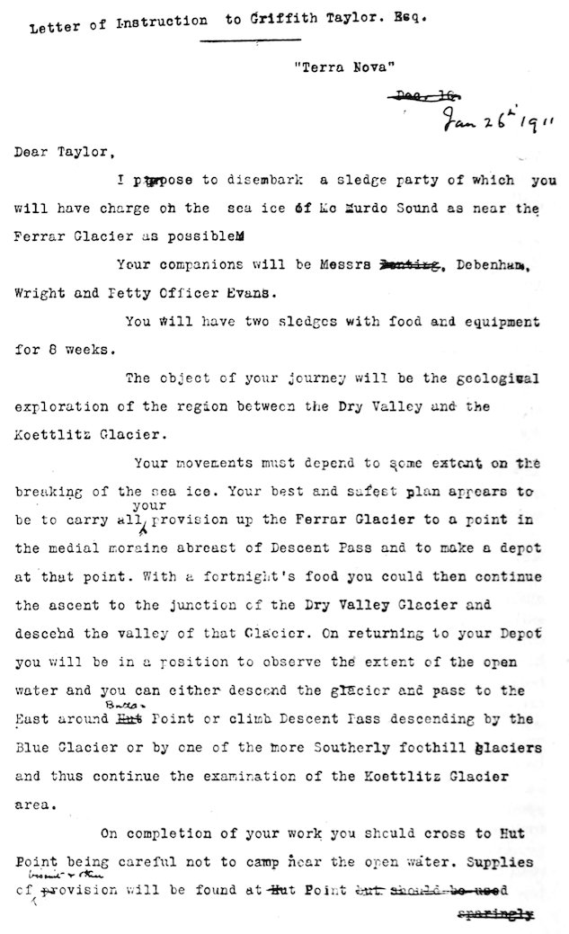
We returned and found the “hoosh” nearly ready. I read the sledging orders which Captain Scott had given me a few days previously.
122
123
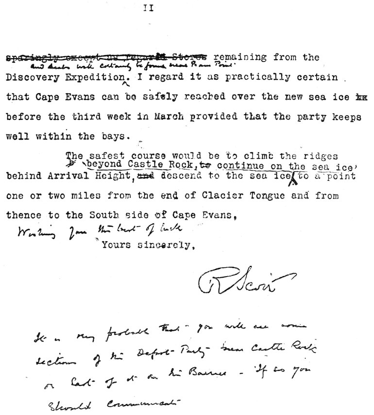
Letter of Instruction to Griffith Taylor, Esq.
124As usual we found the pemmican too rich at first, and I note that I could only eat three of the biscuits! This delicate appetite did not survive many days of Antarctic sledging. I slept soundly, only waking once at four; but the thought that I carried the chronometer and was responsible for the punctual rising at 7.30 (6.30 local time) made me uneasy for many ensuing mornings!
We did not expect to return by this route, so that I thought it advisable to investigate the physiography of the lower end of the glacier. After breakfast we all went over to the south side of the valley. Wright was soon busy on hands and knees investigating the beautiful “fan” crystals. Debenham and I walked on further to some isolated moraine heaps, which projected about ten feet above the ice. I made a traverse over the glacier as far as the lower slope of the hills with the following results. The moraine heaps seemed to be the outward and visible sign of a large continuous ridge—or sheet—most of which was buried in old ice and snow. The mingling of fine silts and huge boulders, some four feet long, was characteristic of a glacial deposit, and a few doubtful striæ were present. Many varieties of rock were represented, granites, recalling the famous “Shap” of the Lake District; splendid porphyries with large almond-like felspars in a brown matrix; gneisses of many varieties with parallel layers of glistening mica and dull black hornblende; and some crystalline limestones and much dolerite; both of which occurred in situ about ten miles further west. These elongated silt and boulder ridges showed deep cracks along their sides, indicating, I imagine, considerable movement of the glacier which bore them.
The next half a mile was rather difficult travelling, through pinnacle ice and through large lately frozen pools of water. Very striking were some of the ice-forms here. “Topsy-turvy” icicles, whose original support had almost melted away—leaving them attached below and surmounted with knobs like hatpins, and unsupported crusts of ice which dropped one into a pool of water, were types that made the most lasting impression. I soon reached the land—a sunny slope facing the noon sun. Here several merry little brooks hurried down over the powdery silt to hide themselves beneath the glacier. To be sure, they were only an inch deep 125and meandered across little channels a couple of feet wide, but they were unusual enough to excite interest. Gradually the silts changed into a pebbly soil, and this into a uniform layer of coarse gravel as I ascended the slope. Larger stones and boulders became common, and one specimen seemed of special interest. It was a fragment of coarse granite some six inches long, with its upper surface weathered to such an extent that every felspar appeared as a separate glistening brick; yet the moiety of the granite buried in the silt was as smooth as any pebble from the beach. I consider it by no means improbable that this relatively large amount of “weathering” had been accomplished while this fragment lay in its present insecure situation.
A little higher up the slope I was amazed to see a carpet of green moss, as flourishing as any in more temperate regions. I sat down on a granite erratic, and noted that three types of vegetation were present. One was a veritable moss, to my unbotanical eyes, the ordinary moss of universal distribution. Of the other two species, which may have been algæ, one resembled the seaweed called Ulva, and the other had a somewhat fibrous structure. The patch of green was sixty feet long and about fifteen feet wide, and is possibly the largest area of vegetation south of 77½°! I was under the impression that these forms were quite common around MacMurdo Sound, but if I had known that they were inhabited by a most interesting primitive flea, I should certainly have added some to our load. However, we obtained thousands of the insects next year at Granite Harbour.
On my return I found that Evans had laboriously collected the fragments of a shell, which, pieced together, built up a red scallop. He picked it up on the moraine, where it may have been blown by the wind.
We inspanned at noon, and before lunch reached the low ridges marking the junction of the centre of the glacier with the sea-ice. Here we obtained fresh water for the cooker, by cutting some three inches through the sea-ice. Evidently at this season the sub-glacial drainage overpowered the sea-water at this spot, which was eight or nine miles from the open sea.
To the north of this was that remarkable “Double Curtain” glacier, which is photographed in the Discovery volume. After lunch Wright and I decided to walk in that 126direction, and we soon saw we should be justified in devoting some hours to its examination; while Debenham came along later and collected the varied rocks in the vicinity. As we approached the northern slopes the surface of the Ferrar Glacier altered in character, and gave place to large lake-like areas of ice, which exhibited most beautiful figures on close examination. In the upper layers of the ice were included radiating designs which resembled a miniature Hampton Court maze in porcelain embedded in glass. These intricate patterns—which are characteristic of glacier ice—I termed “Arabesques.” They are due, I imagine, to some variation in the solidifying water, perhaps owing to air being squeezed into the latest ice formed—or again show where stones have sunk deep into the glacier.
Somewhat nearer the shore there were more unpleasant surfaces met with—large dome-covered ponds into which we fell at frequent intervals. We decided that a tramp over the Crystal Palace would give rise to the same sensations. Bounding the glacier and separated from the debris slopes by a wide stream was an avenue or colonnade of gigantic ice pinnacles thirty feet high. These were traversed by narrow crevasses, down one of which I had to climb to rescue an ice-axe. The sun glistening on the icy minarets and beautiful icicles made a most impressive sight. This ice ridge is due to pressure from the glacier piling the ice against the cliff higher up. This crenellated selvage to the more level central level centre of the glacier—moves to the sea with the main body, and so preserves its lateral position, though no pressure can exist where we saw it—for it is many yards from the rock.
Between the pinnacle ridge and the slopes was the water-bearing channel which invariably accompanies a large glacier in these regions. This physiographic feature is one of the most interesting and most important in connection with the characteristic topography of Antarctic valleys. The small valley bounded by ice on one side and rock on the other is conveniently termed the Lateral moat. Hereabouts it was rather complex, but further up the main glaciers its valley occupied merely a simple V. After crossing the pinnacles we had to negotiate a stream in which the water lay in pools several feet deep—though its flow was comparatively small. Then over a silt moraine and so across another slight 127depression to the talus slopes below the “Double Curtain” tributary glaciers. It seemed a simple matter at first to investigate the glacier front, but it lay much further up the slope than I had imagined, and was moreover protected by an icy mantle of frozen thaw water which surrounded the snout. Wright cut steps across this “mantle,” and found that the almost vertical face of the glacier was forty feet high, and composed of layers of snow which had only lately reached the condition of ice.
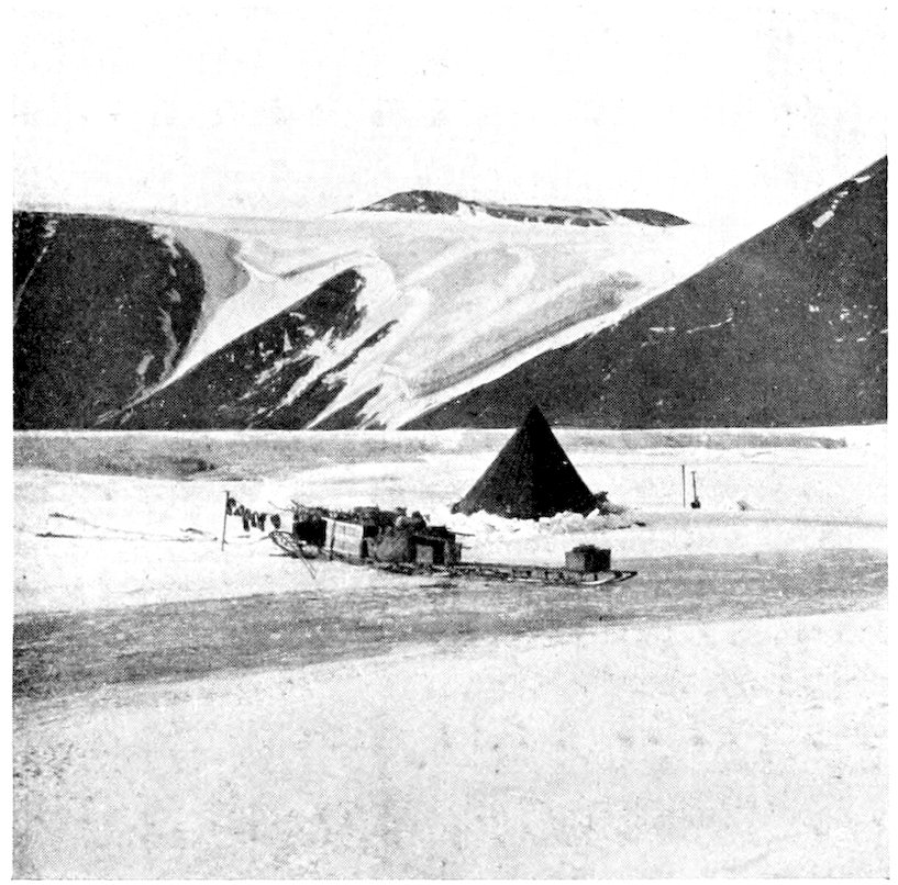
MY FIRST CAMP IN ANTARCTICA AT THE SNOUT OF THE FERRAR GLACIER. Over a mile away is the Double Curtain Cliff Glacier. The Kukri Hills are 3000 feet high. The Snout is only ten feet above the sea-ice on which is the tent. The socks are hung out to dry on the sledge.
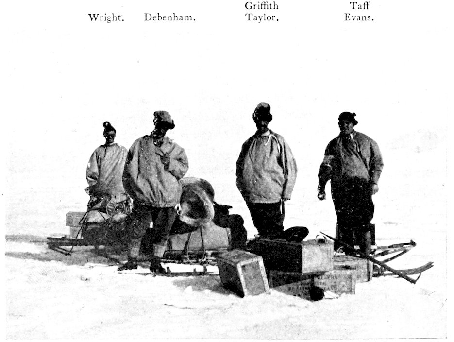
PHOTO TAKEN JUST BEFORE WE PACKED THE SLEDGES FOR THE FIRST SLEDGE JOURNEY, Jan. 27, 1911. Note the biscuits in the four venesta cases. The men are wearing windproof blouses. [See p. 120.
Meanwhile I climbed up the steep rock slopes alongside the glacier. At first the rocky debris was a confused jumble of granites, dolerites, and basalt, with occasional limestones and gneisses. At 2500 feet elevation I reached the top of the slope and stood on the great shoulder which characterizes the Kukri Hills hereabouts. Here solid rock was plentiful—the same gray granite traversed by long dykes of dark basic rock. A wonderful panorama was spread out before me. I could see up the Ferrar Glacier as far as Knob Head. To the south-west jutted out the three giant gables—like the roof of a Gothic cathedral—which were so appropriately named Cathedral Rocks.
I was much interested in my first view of Descent Pass, by which we proposed to reach the Koettlitz Glacier. Still further to the south-west the spurless wall of the Ferrar was notched by the “Overflow.” The latter appeared to spill out through a gloomy curving gorge which indisputably showed evidence of water erosion. In the far west towered the massive Royal Society Range, culminating in Mt. Lister. Its eastern face was carved into rounded “armchair” valleys (cwms) and deep razor-back ridges—another type of topography which has been recognized in temperate regions as characteristic of glacial erosion.
On descending to the main glacier I found that the others had collected several small sponges and shells from the small silt moraine in the lateral moat. These organic remains are puzzling, for it is difficult to imagine that such light and fragile specimens indicate a sea-beach, which could only have raised so many feet above the sea at some far distant period.
Objects of greater biological interest had been encountered on our walk to the side of the glacier. In the rough ice we saw many Emperor Penguins, stolidly motionless and 128obviously awaiting the end of their moulting season. We crossed over towards them and found that there were several flocks, probably totalling one hundred.
In the nearest group were thirty-six individuals, only one of which had completed moulting.
He was singled out for sacrifice and fell by a blow on the neck. Evans and I dragged him to our camp, where I skinned and cleaned the carcase in preparation for a change of diet if our appetite failed on a pemmican regime. The limbs I hacked off with my new bowie knife, and I was chagrined to find that penguin bones can chip the best Sheffield blade!
Already my boots began to give trouble. The soft leather sole would not hold the short nails, which only were available on the Terra Nova, so that I attempted to mend matters by driving in some Canadian lumber spikes supplied by Wright.
After Wright had taken another round of angles with the theodolite we moved on up the Ferrar Glacier. The surface degenerated rapidly. The flatter portions were sun-carved into serried ranks of projections like plough-shares, and we used the term “Plough-share Ice” to describe this feature. Although this was unpleasant to walk on, yet the sledges travelled over it readily—for as a general rule bad walking meant easy pulling, and vice versa. But great holes, two or three feet deep, were cut out below the general level, and these were closer together as we moved further west. They were crusted with fan crystals, and indeed represented a stage of surface evolution which I have described as “coral reef structure.” We had much difficulty in guiding the sledges, and they capsized several times before lunch. Every now and again the sledge runners would jam, sending a jar through one’s frame, so that this unpleasant experience became known—quite naturally—as a “jam-jar.”
Towards evening we approached the first series of pressure rolls. Crossing diagonally (from south to north) were four frozen rivers which formed tempting surfaces, but unfortunately in the wrong direction, for they led to the broken ice of the Overflow.
We camped in an undulation filled deeply with hard snow, a little below a fine tributary glacier and nearly opposite the Overflow.
129On the 30th we started up some steep undulations. We had anticipated easy going, for Evans, on his 1902 journeys, had always encountered clear smooth ice here. But the ice was buried under a foot of snow and only showed in occasional holes. I made brief notes of the surfaces throughout the day, at our various halts, and they are characteristic of glacier sledging and so are here reproduced.
“First Halt. Heavy going up the undulations; three of them traversed already; the surface is smooth but the runners stick to the snow.
“Second Halt. We have crossed the head of quite a deep snow-covered valley crossing the glacier,—on both sides were numerous crevasses, but they were not wide, the largest being under three feet. I slipped in twice, and Evans and Wright had similar mishaps (in no case, however, did both feet go in). Definite snow bridges over crevasses. We halted at a dead seal, obviously a young specimen and yellowish in colour.
“Third Halt. We can see a good lateral moraine at the foot of the cliffs, for we are gradually rising up a steep slope with a bad surface. Only a few narrow cracks.
“Fourth Halt. Still on the same slope, which is hard going and causes much sweat, chiefly owing to our rather heavy loads, as the slope is only three degrees.
“Fifth Stage. Same surfaces; stopped for lunch, having done 3600 paces in three-quarters of an hour (fide pedometer).
“Sixth Stage. The surface became less damnable and we did a mile in which short patches of ice appeared under one inch of powdery snow. Some ‘glass-roof’ ice is appearing into which we fall, and the snow is still one foot thick in many places.
“Seventh Stage (5 p.m.). We are reaching plough-share ice.
“Eighth Stage. Snow is falling on the northern slopes, but does not reach down to our level.
“Ninth Stage. Much better surface, nearly all ice, though the snow has powdered it to a greyish colour.
“Tenth Stage. ‘Arabesques’ are showing in the clear ice underfoot, they seem to mark fairly old solid ice and indicate good travelling.
“Eleventh Stage (8 p.m.). Crossing the glacier to Cathedral Rocks; surface good, but the moraine seems a long way ahead.
130“Twelfth Stage (9 p.m.). Stopped near the big moraine after heavy pulling over two inches of soft snow. Camped on big patch of hard snow by a huge boulder.”
We spent the forenoon making our depôt at this camp. It lay four miles north-west of Descent Pass, and would be on our route if we decided to return to the sea by the Pass. We left here what we did not require during our fortnight in the Dry Valley region. We piled three biscuit boxes on the smaller sledge, and packed the smaller provision bags under the sledge. We put the butter inside the instrument box with the spare photographic plates. Also I decided to leave the heavy steel under-runners, for so far we had met with no rough ice. The penguin had been lashed on behind the sledge and had suffered considerably from the capsizes! Him we buried under some blocks of snow, pending a “hoosh” on our return. We took a fortnight’s provisions in addition to the “ready-bag,” and I tied a note to our depôt flag, mentioning the 11th as the probable date of our return.
Just to the west of the main Cathedral Rocks was a very interesting tributary valley—the first real low-level tributary of which we had had a good view. Obviously owing to some difference in the snow-supply, this tributary is keeping pace with the main glacier, and enters the latter “at grade.” The majority of the other tributaries have not entered the Ferrar on a level (at grade) since it was two thousand feet thicker.
The sun was quite powerful, and we had to wear goggles in consequence, but during our ensuing stay in Dry Valley there was so much bare rock that we had no need for them. At lunch my unlucky boots fell to pieces again, and Evans put some scientific sewing into them. But no sewing held, until continual frost turned the leather into a material almost as strong as steel.
Towards six o’clock we reached the top of the steeper portion of the Ferrar Glacier, and found ourselves on a small ice plateau about 3200 feet above sea-level. On the south it rose to the south arm, while to the north was the entrance to Dry Valley. The col of ice leading in this direction is of considerable interest, for it shows what conditions were like near Luzern in the Great Ice Age. However, I will describe this form of “Twin Glacier” in a later paragraph.
A few miles before we camped we were hauling the sledge 131along the foot of the grandest geological section I have ever seen. The cliff was 3300 feet high (as determined by Abney level), and was divided into so many distinct layers that it resembled a gigantic sandwich! It was capped by a little triangle of yellowish rock, which represents the most eastern exposure of the Beacon Sandstone in the valley. Beneath this were two wonderful “sills,” or horizontal sheets of the basic lava called dolerite. They could be traced in the cliffs for miles and miles, and represented flows of lava wedged in between the granites and sandstones. These dolerite sills were strongly columnar, and near by some isolated pillars of enormous size were visible on the skyline. Above and below the lower of these black sills were layers of grey granite, and the lower portions of the granite were shrouded in a steep slope of brownish talus which reached to the flashing white surface of the great glacier.
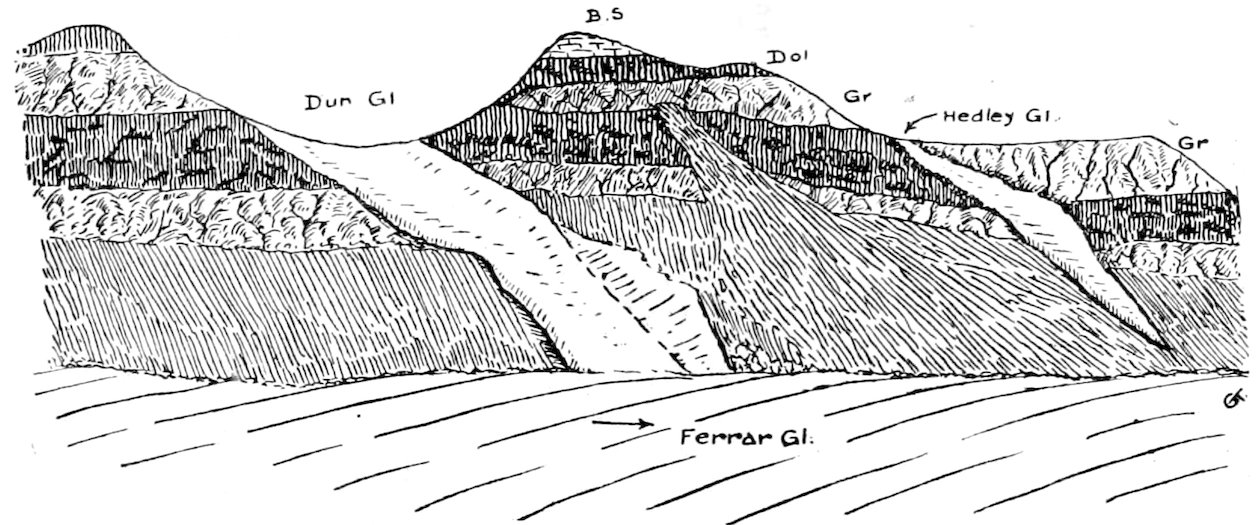
The wonderful geological “sandwich” near the Dun and Hedley Glaciers. (The 3000-foot cliff at the south-west end of Kukri Hills, February 10, 1911.) In descending order: yellow beacon sandstone; black dolerite; red-grey granite; black dolerite; red-grey granite; dark brown talus.
I hoped to reach the head of the Dry Valley glacier that evening, so that we pulled on till 9 p.m., and reached the beginning of the slope to the north. Here we formed our Fifth Camp just abeam of a tributary glacier—which, from its shape, we called the “South America” glacier. We had some difficulty in fixing the tent-flaps, for the glacier was now practically free from snowdrift, and there was nothing to weight down the skirt of the tent. But the night was calm and warm, so that I walked across to the lateral moat without helmet or gloves in perfect comfort.
132February 1, 1911.—To our surprise—after five days’ pulling over heavy snow in the Ferrar Glacier—we found no snow in the adjoining valley! We made across the valley a little to reach the medial moraine, and to get away from the disturbed ice at the corner. At lunch we camped in a huge hole alongside a giant boulder of granite. Here alone we found enough snow to secure the tent. Water was obtained from a mass of slushy ice on the sunny side of an adjacent boulder.
Many points of interest appeared round us. All over the clear ice were circular patches of darker ice, varying in size from an inch to two feet. Embedded in the darker ice were the arabesque patterns described previously. These dark patches marked where stones had gradually sunk through the glacier, as the sun’s rays—rendered operative by radiation from their dark surfaces—melted the ice around them. As a consequence, only the most massive blocks remained above the ice hereabouts, and the medial moraine—in place of being a continuous ridge of heaped debris—consisted of a block here, another twenty feet off, a third somewhat further, and so on along a line down the valley.
On the slopes of the north, under Obelisk Mountain, were two interesting glaciers. We named them from their shape “Catspaw” and “Stocking” Glaciers. They spread over a low range of hills shaped somewhat like a broad terrace, and from my sketch it seems possible to prove considerable retrogression on the part of the “Catspaw.” In 1903 the “paw” was furnished with relics of a well-defined “mantle” in the form of three “claws” prolonging the glacier some hundreds of feet. There was no trace of these in 1911. The irregular outline of this glacier suggests that it originally spread out and perhaps joined with the Stocking (to the east) and other isolated curtain glaciers. Hence the absence of any trace of a valley below these glaciers. They merely “spill” over the broad terrace and hang there supinely, quite unconnected with the main glacier below. This absence of marked erosion is, to my mind, a very important point, and similar features constantly occur.
The gullies in the Solitary Rocks afforded an interesting piece of evidence as to the relation of outcrop to weathering. One of the trials of physiography is to decide how much of the outline of a valley must be set down to the varying 133resistances of the rocks involved, and how much is due to the generalized type which marks the physiographic age of the valley. For instance, a narrow gorge usually marks a valley of late origin; but it may be due to a hard band of granite and be quite local, the rest of the valley having the broader features of the mature stage of erosion. To return to our local evidence. I was glad to see that the gullies intersecting the Solitary Rocks crossed the unconformity (junction) between the dolerite and granite without any change in their outline, proving that these two rocks offered much the same resistance to weathering.
As in the Ferrar, the frozen surface streams ran across the glacier diagonally towards the north-east. Perhaps this uniform northerly direction was due to the greater melting on the northern side of the glaciers by the noon sun.
About six o’clock the slope became too steep for the sledges. We halted, therefore, about a mile from the snout and prospected for a good camp site. There was no snow anywhere, and the edge of the glacier was a steep slope some forty feet high, down which it would be little advantage to lower the sledge. The centre of the glacier was cut up by surface streams into asymmetric gullies twenty or thirty feet deep. Along the sunny (southern) side of these gullies were a series of “alcoves” arranged like the stalls of a choir. They were thirty feet deep, and about a hundred across, and were most beautiful objects—their steep faces being fretted into a thousand pilasters and niches.
On the northern side these alcoves were much smaller, but presented the same features. We lowered the sledge down a convenient gully in the wall by means of the alpine ropes, and proceeded to pitch our tent on the rough ice forming the level floor of the alcove. These were ideal conditions for a sheltered camp—with the exception of the floor. We had a strongly-running stream an inch deep alongside which led to an amusing incident one evening. However, it was a good site, and though the wind howled along the surface of the glacier, nothing was even disturbed in our sheltered nook.
I decided to spend two days round the snout of the glacier before moving down the valley towards the sea. The “groin” blocking the valley attracted my attention, though I was 134afraid it might prove to be merely a 500-foot moraine. So we arranged to spend the day in the matters most interesting to us. Debenham climbed up some 2000 feet to the “coaly” debris on the Kukri Hills. Wright (and Evans) investigated the physics of the ice in the vicinity of Alcove Camp. Debenham and I started together down the glacier, and experienced considerable difficulty in leaving the ice. Captain Scott had descended easily enough in 1903, so we kept along the southern edge, seeking a convenient place. The steep lateral slope gave way to a perpendicular cliff over fifty feet high, and we had to cross many ridges and small crevasses before we came to a gully which led to a “silt” fall. Here, partly by slipping and partly by being lowered by the wickstraps of my gloves, I managed to reach the lateral moat, and Debenham followed safely. (Afterwards Debenham cut steps up the less steep face nearer our camp.)
Debenham finally climbed to an outcrop of black lava forming a wall eighty feet high, and obviously representing quite a late phase of volcanic activity.
I carried lunch with me down the valley, and ate it under a huge granite erratic abreast of the snout of the glacier. The slopes of the hills contracted here, and practically enclosed the glacier save for a deep narrow gorge just under the 500-foot groin mentioned above. The slopes were strewn with fragments of grey granite, of fawn granite, and of a felsite containing hornblende laths and “zoned” felspars. Many of the basalt fragments seemed to show the effects of wind action, and exhibited the wedge form of “dreikanter.” The latter are elsewhere characteristic of desert regions, where also wind action is more pronounced than water erosion. Many of the large granite erratics contained felspars three inches long, and every gradation between granite, gneiss, and felsite seemed to be present.
Many interesting features were shown by the glacier snout immediately below me. Between the groin—which I named the Bonney Riegel—and the glacier, extended an oval lake about a mile long, and half that in breadth. This connected with a much larger lake to the east by a deep waterway through the Bonney Riegel. The whole lake—some four miles long—I named Lake Bonney, after the President of the British Association, himself a climber and student of the Alps. Between 135the lake and the actual face of the glacier was an area of distributed silts, which extended under the glacier; while the latter also contained bands of silt, which were boldly curved in the form of an arch with the centre thirty feet above the limbs. Here the glacier can be exerting no erosive action on its bed, and I believe that for a long period thaw and freeze, wind and water, have been the chief agents in eroding the Taylor Valley hereabouts.
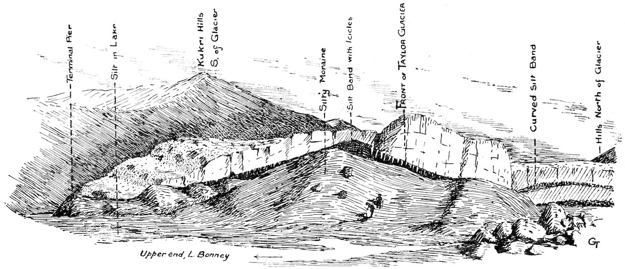
Moraine material at the Taylor Glacier, looking west.
136Leaving the glacier and the upper lake, I proceeded east to the Riegel. As I climbed up the slope of the hill, I was delighted to find that it was composed of granite in situ. This bar across a great glacial gorge was paralleled by many in the Swiss Alps, and any light which can be thrown on their occurrence in the path of an apparently irresistible power like an immense glacier, will be of interest.
In my opinion this bar (or riegel), and the more important one we discovered some ten miles east, are relics of “steps” in the original topography. A series of “armchair valleys” (or cwms) were first cut out in the sloping margins of the newly snow-covered land area. The plateau ice in the interior gradually grew in extent, and finally overflowed and drained out through the largest cwm valleys to the sea. By degrees it eroded many of the cwm features, but it left relics of their presence in the form of these “bars” and basins. This is what I call the “palimpsest” theory, and I shall explain it more fully when I describe the elongated valleys of the Koettlitz ice tributaries.
I slid down the steep eastern face of the Riegel, where King Frost had gnawed away the cliff and built up a steep ramp of talus, and reached the channel connecting the two parts of Lake Bonney. This was twenty feet deep and filled with water, of which only the top six inches was frozen. Large laminae of dull green algæ covered the bottom of the lake, and just at the snout of the glacier a bright red alga lent an unusual touch of colour.
Perched high up on the shoulder of the valley and close to the Rhone glacier, Debenham made out a small black crater, and I got a fairly good telephotograph of it from our camp. It is probable that the basalt debris I found near the lake had fallen from this crater, which was several hundred feet wide. Its position on this glaciated shoulder is very 137interesting, and seems to prove that eruptive action occurred here since the period of maximum glaciation. I managed to cut steps up the front of the glacier and so enter one of the many surface gullies. I had a very unpleasant time getting back to Alcove Camp, a distance of nearly two miles. I thought perhaps the northern side of the glacier, which was flatter, would be easier to negotiate. But the sun had weathered it into a series of small alcoves, whose floors were as smooth as glass and sloped towards the edge of the glacier, here fifty feet high.
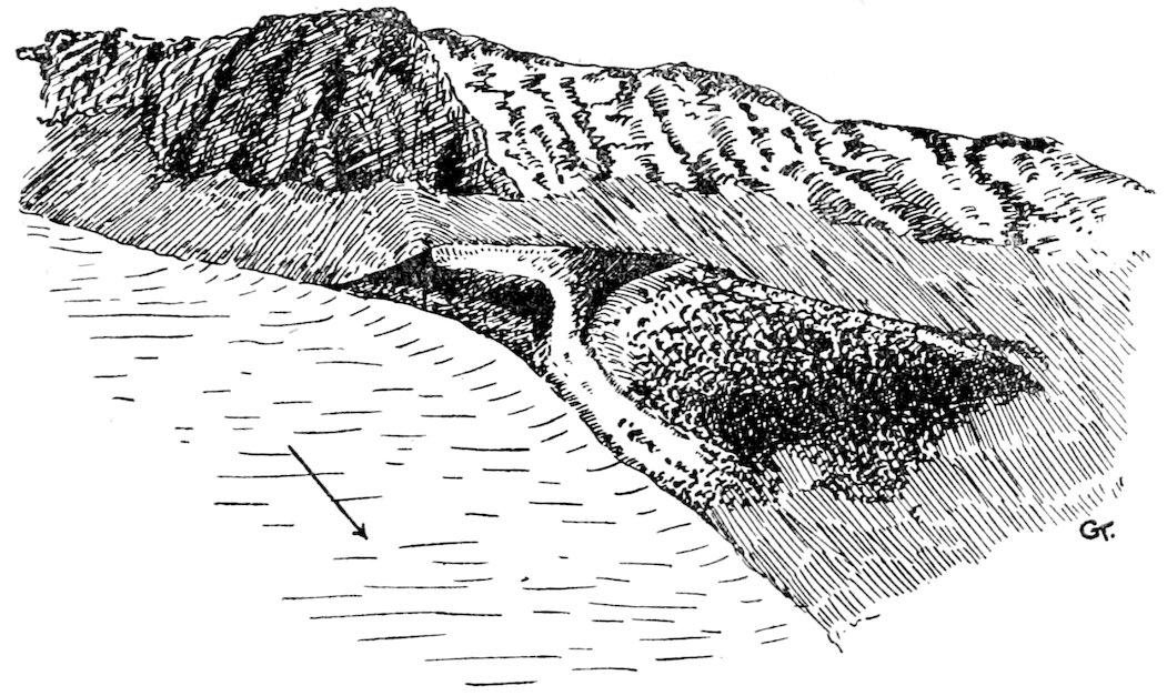
The recent crater on the flank of the Taylor Valley. The Rhone (cliff) glacier appears on the left, February 7, 1911.
The alcoves were bounded by razor-like ridges, and I had to crawl along from one to the other, where I did not cut steps. The others had returned to camp earlier, and Evans proudly produced a fossil-bearing specimen which he called a “whisker-stone.” It certainly showed signs of organic life, but they were merely fibrous algæ of a type fairly common in the south, so he did not get the reward for the first fossils. That evening Evans kindly sewed “toggles” on my sleeping-bag, so that I could lash it up after I had coiled in. We cut trenches in the ice to lead the thaw waters away from the tent, and turned in to sleep soundly, though the wind was howling above us along the face of the glacier. But twenty feet below, snugly sheltered in the alcove, nothing disturbed us.
138Next morning before rising Wright remarked on the severity of his exercise the day before, which had left him so bathed in perspiration that he felt clammy all night. On examining his sleeping-place, however, he found that something had blocked the stream by the tent, and its icy current had been flowing under his bag most of the night. With the temperature ten below freezing this hydropathic treatment was by no means appreciated by him!
February 4, 1911.—As we could not take the sledge beyond the glacier, we packed up the tent and sleeping-bags with five days’ food and our instruments, and carried them down towards the sea. Wright carried his pack in the Canadian method by a “tump-line” round his forehead. He took the theodolite. Evans wrapped his goods and the tent round the tent poles and carried them like a standard over his shoulder. Debenham and I took the food. I found as usual that the Italian method of carrying a harp—a strap over the right shoulder—suited my convenience best. Debenham copied the Australian swagsman with a smaller bundle in front nearly balancing a roll on his back. We took no cooker, and I left my camera below the Riegel after taking some photographs of the latter.
We walked along the northern edge of the lake over a belt of smooth ice about twenty yards wide. The water here was very deep, especially where steep cliffs fringed the lake. Towards the centre the ice soon became much broken, and then a large portion of the centre of the lake was occupied by silt and morainic debris. In fact, the deep water was probably controlled by the radiation from the dark rocks along the shore. The valley was by no means steep-sided as a whole, but there was evidently a well-defined shoulder terrace about 2000 feet above the lake bed on the north and a less marked one on the south. Above them the slope was steeper.
Running into the lake at the east end were several small creeks. One I noticed particularly had cut a fine gully in the moraine of the typical ᐯ shape. This was twenty feet deep, and its debris was deposited as an alluvial fan or delta. I mention this as an instance of typical water erosion in Antarctica, though later we saw much larger examples.
We had lunch at the east end of Lake Bonney, which 139extends four miles east from the snout of the Taylor Glacier. Here the wide valley was filled with morainic debris, and several tributary glaciers were close at hand. A large hanging glacier almost reaches the level of the lake. It is fed by three separate firn-fields, the ice being precipitated over a steep craggy cliff, and then reuniting into a broad glacier below. This I called the Sollas Glacier. Another similar glacier on the northern side almost reached the middle of the valley, and we passed just under its snout. The water from all these glaciers drained into Lake Bonney. I was much surprised to find that after we had passed the lake, the bed of the valley began to rise. This lake evidently occupies an area of internal drainage, and we pressed eastward wondering if we should be stopped by a range of hills. Evans had mentioned seeing in the distance (in 1903) a glacier which completely blocked the valley, so our supposition was not beyond possibility.
Immediately east of Lake Bonney the bed of the valley was occupied by curious areas which Evans’ name of “Football Fields” described quite well. These were four oval areas about 1000 yards long and half that width, as level as a playing-ground and composed of a gravelly silt with insignificant shallow streams winding through each. Separating the “Fields” were ridges of moraine about fifty yards across. The “Fields” gradually became higher in an easterly direction, each, however, maintaining its own particular level. These isolated patches of dead level in the midst of a wilderness of moraine heaps often a hundred feet high need explanation. Level areas of silt under any conditions denote material deposited at base level. (This may be the permanent base level of all water erosion, i.e. the level of the sea, or a temporary level, as when a river enters a lake, the latter acting as a base level until it is filled.) The “football fields” represent, therefore, the last stages of a chain of lakes which occupied the bed of the valley at this point. Probably Lake Bonney will gradually be silted up in a similar manner, though here conditions are abnormal, for the drainage is a thorough puzzle. The lake would seem to have no outlet, and yet, as we have seen, it is quite shallow except a mere fringe near the cliffs. In midsummer a great quantity of thaw water runs down from the main glacier. Possibly evaporation and ablation may balance the inflow. It seems improbable that the water soaks 140out through the moraine in view of the frozen condition of the moraine a few feet down.
From the football fields we passed under the snout of Lacroix Glacier. This ended in a vertical cliff of ice some thirty feet high, which as usual rested on debris and moraine material.
This glacier was a beautiful example of an avalanche-fed cliff glacier. There was very little connection between the upper firm portion and the lower solid snout of the glacier, the supply being maintained by occasional falls of ice over the great granite cliffs separating the two portions.
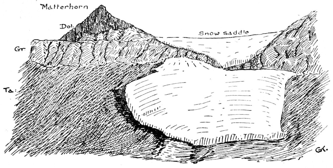
The avalanche-fed Lacroix Glacier in the Taylor Valley, February 7, 1911.
Below the snout there was a steep fall through boulders and fragments of granite to the centre of the valley, and along this slope hurried a pleasant little brook three feet across and some three inches deep. It filled the air with as cheerful murmurs as any stream in more favoured latitudes. Lying among the moraines within the next few miles I counted no less than thirteen dead seals in various stages of decay. This fact was of some comfort to us, for we seemed to be ascending continuously, and could see no seaward outlet to the valley. Yet the seals had come through somewhere, and where they could pass, so surely could we!
About three miles beyond Lake Bonney we reached the water parting. The drainage from these high moraines was partly into Lake Bonney and partly to the east. Beyond we could see the valley contracting to a defile while striking knobs—recalling 141the Bonney Riegel—bounded the narrow gorge and led to terraces about 1700 feet high. To the south, however, an extension of these, 3000 feet high, quite barred the large valley we had just traversed.
It was now nearly six o’clock and my shoulder was aching with my pack. Judging from the readiness of the others to drop their loads, I concluded that they felt the same. But we all had an idea that a few minutes later would give us a view of the Ross Sea. We wondered if we could pass around the snout of the wonderful tributary immediately in front. It opposed a face of ice forty feet high; but just where it butted into the steep south slope of the defile, there was a narrow gap where thaw-ice had filled in the interspaces between the cliff debris. Over this we carried our packs; over this the seals must have laboriously crawled to die further inland. One seal reached no less than twenty miles from the sea, and ascended many hundred feet on its death journey. Another, near Solitary Rocks some ten miles further west, at a height of 2000 feet, may have ascended the Ferrar Glacier—an incredible journey for a marine animal like the seal.
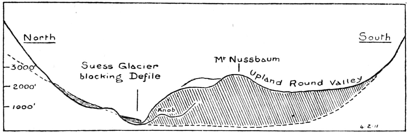
Sketch section across the Taylor Valley at Suess Glacier, showing the Nussbaum Riegel which bars it.
We scrambled up the slippery ice mantle below the snout of the Suess Glacier—as we named this striking glacier—and reached the highest portion of the valley since we had left the Taylor Glacier. The rock slopes looked full of interest. Here were vertical strata of limestone and slate, which were the first sedimentary rocks that we had examined in situ. Unfortunately they were so folded and altered that no trace of fossils could be expected.
We could not see the sea from the crest of the defile, 142where we were about 300 feet up, and so moved east down the other slope. We reached another lake nearly a mile long with a splendid gravelly shore, on which I decided to pitch the tent. We had brought no floorcloth; but after the wet and icy floor in the “alcove” we found the warm gravel most comfortable.
We had a frugal meal of biscuit, butter, and cold water. Our beverage from the lake was distinctly medicinal, and as the latter had no outlet we called it Lake Chad.
I was distinctly troubled over the topography of the day’s march. We had left a huge open valley—a suitable outlet for a large flow of ice like the Taylor Glacier—and had arrived at a narrow defile completely blocked by the tributary Suess Glacier. We reckoned we must be near the sea; but where was the large open moraine-strewn valley described by Professor David in 1908? I wondered if we had got into an unimportant tributary and missed the main outlet of the valley altogether! So after dinner Evans and I made straight for the top of the ridge (immediately south 143of the tent) which seemed to block the great valley. It was a stiff ascent of 1600 feet over rough blocks of slate. There we reached a flat, bare ridge with a further ascent to 3000 feet a little further west. To my surprise I saw that immediately to the south was a broad high-level valley gradually sloping to the east. I thought at first I was looking into the Ferrar Glacier, but soon saw that here in Antarctica was an example of the extraordinary valleys which are so characteristic of the Italian Alps. As shown by the cross section, the dry valley is barred by a huge Riegel, which is traversed by a deep defile at the north, and scooped out to some extent into a huge elevated, rounded channel on the south. From this ridge, above the mile long defile, Evans and I at last saw the sea gleaming in the east across some twelve miles of moraine-strewn valley.
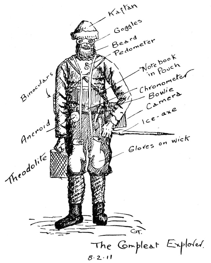
On the 5th, Wright and Debenham remained near the camp, while Evans and I marched down to the sea to tie the survey on to Ross Island—if we could recognize any portion of that far distant feature. We each carried much gear, and the annexed rough sketch shows how a geologist is loaded when “on trek.”
It was extraordinary to find two more very large tributary glaciers on the south side of the valley—reaching some way into the ice-free main valley, and blocking up the main drainage to form a series of lakes. We named the first the Canada Glacier, and Wright later on clustered the names of various Canadian men of science on the adjoining peaks. The second we called the Commonwealth Glacier; and to the small glacier which we ultimately reached, on the north-east end of the Kukri Range, I gave the name of Wales Glacier, so that our party’s homelands are well represented in Dry Valley! We had to climb 400 feet up the slopes here before we could see anything definite to the east; but then I was able to sight the theodolite on to Mount Bird, Cape Bird, and Beaufort Island. It was a long and rough tramp back—across numerous little streams, running as usual to the north-east,—but we reached camp again at 9 p.m. and turned in thankfully.
After a somewhat dry breakfast, Wright and I took the theodolite up to the top of the Riegel. We climbed some 2400 feet, but did not reach the top of Mount Nussbaum—the central summit,—which I estimated at 3000 feet high. 144When we reached the scarp facing up the valley to the west the wind was tempestuous, so that we could not stand against it, much less use the theodolite. We sheltered under the lee of some projecting dykes of dark rock for some little time. There came a lull, and almost before we got the theodolite ready the gale had veered to the east—diametrically opposite—and continued to blow almost as fiercely from that quarter. This violent storm would have been unsupportable on the Barrier, but the party in our camp below practically felt none of it. Our apparent fine weather was due less to absence of wind than to the absence of loose snow, and to the abundance of shelter.
I tramped to the south and found that the “Round Valley” 145ended in a 1700 foot scarp above the trough containing Lake Bonney. There was little wonder that we had not realized on our seaward tramp, viâ the defile, that such a high-level valley existed.
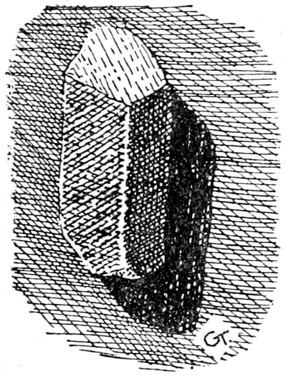
“Anorthoclase” felspar, thrown out of Erebus, 2 inches long. The characteristic mineral in kenyte.
This elevated ridge was comparatively free from debris, but there were huge erratics of granite with large felspar crystals three inches across. They were wonderfully scooped out by the wind, and were nearly twenty feet across in some cases. We also found small kenyte erratics containing large felspar crystals. These may have been carried across from Mount Erebus, or some unknown locality in the south.
After supper I took the prospecting dish (which was the last article purchased in New Zealand) and washed for gold in the gravels alongside the lake. There were numerous quartz “leads” in the slates and metamorphic gneisses, and eruptive rocks and limestone were in the vicinity. This is a juxtaposition which is always promising, and furnishes the “country rock” of most gold fields. But the quartz was too glistening and pure. It had not the “kindly” rusty appearance which the gold-seeker admires, and so I was not very sanguine. However, water was abundant in Lake Chad and I washed out many pans of dirt. The “tails” of heavy sand were not promising, even pyrites and magnetite being almost absent. We knew there would be no water available on the remainder of our journey, so I depôted the “pan” on a boulder by Lake Chad, where some future archæologist will discover striking evidence for the lost kingdom of Sheba!
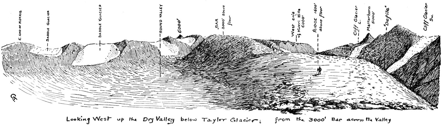
Next day we started back to Alcove Camp, buoyed by the thought of hot pemmican after nearly a week’s cold “tucker.” We lunched just at the east end of Lake Bonney on our old site below the peak of the Matterhorn. The latter is the most striking mountain in the region. The conical summit (formed of black dolerite columns) perched on a broader 146granite base, certainly gives it a resemblance to its forerunner in the Alps. We estimated it to be 9000 feet high. Luckily we took careful angles which we worked out later in the hut. To our chagrin all observations resulted in a poor 5000! Such is the effect of lack of trees or any standard of comparison in Antarctic scenery. Continuing west we found that the penguins seemed to have the same queer habits as the seals, for we found a skeleton some fourteen miles from the sea.
We reached Alcove Camp about 5 p.m. and saw that our camp site was ruined by thaw water. We hunted around for a new floor, and the only available one seemed to be a pile of moraine rubble just like a heap of road metal! This we levelled off, and when the ice had melted away in the sun, we pitched our tent upon this stony bed. Then we had a hot meal, much appreciated after our days of cold food.
We were up at 7.20, Greenwich time (really 6.20, local) and shifted our gear from the heap of road metal to the surface of the glacier. We had a good breakfast, though I noted that twelve lumps of sugar did not seem to sweeten the cocoa. It was difficult to move the sledge, for the dark straps had sunk two inches deep in the hard ice and there frozen in again. We managed to get everything ready by 10 a.m., and moved up the glacier. It was very sunny, and Evans wore a huge “Madeira” straw hat, quite a yard across—a queer but useful article that his previous experience had led him to add to his kit.
We had lunch about six miles up the glacier in the medial moraine. I took careful notes of the latter, which differed conspicuously from those of temperate glaciers. It consisted of huge blocks of granite with smaller pieces of dolerite and sandstone. They were often 100 feet apart, so that this moraine compared with Swiss examples was a very “tenuous thread.” Comparatively little material can be supplied to these slow moving or stagnant glaciers, and all the small stones have undoubtedly sunk into the ice long ago.
The upper portion of the Kukri Hills hereabouts showed by the fragments of the Beacon Sandstone torn off by the intrusive eruptive rock dolerite that the latter was newer. The relative ages of the other rocks could be deduced in the same way. For instance, the dolerite sent “dykes” into the 147granite, so that the latter was older. These points are well shown in the section I sketched.
Near the Solitary Rocks the glacier was moulded into a gigantic furrow or longitudinal undulation. We followed this up toward the ice-falls from the upper glacier and camped for the night on a small patch of snow in the lee of some large boulders of the medial moraine. These boulders had lee-ridges of snow, which, we were interested to see, were generally turned into solid ice and formed part of the glacier itself. This shows that nothing but a maturing process (resembling that of wine!) is necessary to convert snow into glacier ice.
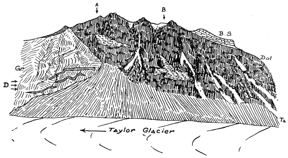
The age of rocks. The granite (Gr.) is the oldest; it is penetrated by flat sheets of dolerite (D) at the junction with the main mass of the latter. The beacon sandstone (B.S.) has also been torn up and surrounded by the dolorite (below A and B), and has probably been lifted up by the lava (to B.S.). The talus (Ta) of loose rock is the latest deposit. From a sketch of the new end of the Kukri Hills made February 1, 1911.
Wright and I went over to the Kukri Hills while the others pitched camp. I wished to measure the “lateral moat.” Near the edge of the glacier there was a thick coating of snow. At the actual edge there was a sharp curve downward, and carefully peering over we could see that there was a frozen stream at the bottom of the gully, over 150 feet below us. I determined to measure the slope and angle accurately, and for this we had brought the alpine rope and ice-axes. Wright lowered me over the edge, which I found was a snow cornice projecting over six feet. Under the 148cornice was a well-defined platform a few feet wide—which, however, narrowed on either side—and then came a long slope to the bottom. Wright paid out the rope, and I let myself down to its end. There I started to cut steps, but unfortunately slipped and fell the last thirty feet—luckily without damage except to my knuckles. I can remember thinking that an ice-axe was an uncomfortable companion in this roll down the slope and so threw it away for fear lest it should claim close acquaintance with my person. The stream was over a hundred feet wide, and then I reached the foot of a steep rocky slope formed of dolerite blocks fallen from a bold crag a few hundred feet up.
I climbed up the glacier side again, and then found that the large snow-shawls of the cornice prevented my getting back—for as Wright hoisted me the rope merely cut deep into the snow and soon my head was pulled into the lower parts of the huge cornice! I crawled along under the cornice, devoutly trusting it would not avalanche on me, but ultimately had to retrace my steps down to the stream. Again I slipped, and this time lost the skin off my other hand as I rolled once more into the moat. Luckily some few hundred yards north I saw a place where the cornice had fallen off, and here I was pulled up by Wright with such vigour that the ice-axe entered my leg!
The huge cross-section of these “moats” is worthy of note. They definitely prove that no lateral erosion of any importance is occurring in this portion of Antarctica. After returning to the tent the glacier treated us to rounds of volley-firing! These were due to the opening of contraction cracks as the ice shrank in the colder night temperatures.
Wright and Evans spent the morning of the 9th over near the ice falls from the upper glacier. These we named after the famous Cavendish laboratory in Cambridge. They had to cross a surface compounded of “plough-shares” and “thumbmarks,” which they found intensely slippery, so that even surefooted Evans fell and nearly broke his elbow.
Debenham and I cracked sandstone boulders, but found nought of interest save worm burrows in some shaly bands. However, these indicate damp conditions for some portions of the Beacon Sandstone, and so show that the latter is not perhaps of desert origin.
149The most extraordinary feature in this small ice plateau near Knob Head Mountain is that the moraines here lead down into Taylor Glacier. Hence they cut right across the upper portion of glacier above Cavendish Falls, and show that the ice west of the latter is almost wholly flowing into the Dry Valley region and not into the lower Ferrar, as was supposed. This looks as if the “South Arm” and the glacier from the north side of Mount Lister formed the main supply of the Lower Ferrar, while the northern portion (née Upper Ferrar and Dry Valley) is a distinct glacier now temporarily united with it after the fashion of the Siamese twins. This type of union is by no means unknown, and indeed explains the structure of Lake Luzern—that beautiful high-cragged chain of lake basins in central Switzerland. Here also two independent glaciers (the Reuss and the Aar) cut out deep parallel gorges as they moved to the north.
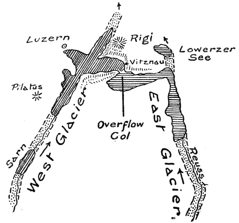
Plan of the bygone twin glaciers of Lake Luzern, whose overflow led to the break through the high range near Vitznau. A close parallel with the conditions near Knob Head between the Ferrar and Taylor Glaciers.
They spread out laterally, and ultimately the Reuss Glacier overflowed to the west, and cut through the high ridge forming the picturesque cliffs of the Rigi and opposite shores.
150As I have explained elsewhere (p. 280), when, after our return, I described this interesting parallel between Lake Luzern and the “opposed” glaciers at Knob Head, Captain Scott was good enough to honour me by naming the northern “twin” the Taylor Glacier.
That evening we camped near the ice divide between the glaciers. We had intended to ascend the South Arm, but after making our way in that direction for some time, we saw that a snowstorm was brewing, and so turned towards the Kukri Hills.
They seemed to me less than a mile distant, but knowing the difficulty of judging distances, I suggested we should camp under the slopes, “about a mile and a half on.” Wright, with his Canadian experience, thought this would be well over two miles, and I remember the distance turned out to be three miles! Thereafter I calculated apparent distances with great care, and when convinced I had allowed for everything I would use a “factor of safety” of 3—and come out about right!
Debenham finished cooking, and being already an adept, had very properly saved some “thickers” for his final “flutter” at breakfast. So Wright started with the evening meal. He imparted a scientific and physical aspect to the operation by suggesting a “drop test” to estimate the viscosity of the pemmican; an observation of its meniscus (or curved surface) to see its sticking power; notes on colour and taste; and—added one of his hungry audience—“I suggest 50 per cent. be subtracted from the cook’s allowance on account of grits!”
Perhaps as a result I had a dream in which my astral self did some logical reasoning! It is a fact that the fossils called trilobites gradually become more supple and less clumsily built as one traces them through newer formations. It occurred to me in the dream that this also held true for man and his monkey ancestors, and that the stiff, clumsy orang-outang, etc., developed into the limber human acrobat. Not a very epoch-making correlation, but the best my astral self has accomplished to date!
On the evening of the 10th we reached our depôt at Cathedral Rocks. We could see our flag from five miles off with the glasses. On arrival we found the food uncovered, so that the sun had melted the pemmican and butter. The skua 151gulls had found the carcase of the Emperor, and our chance of a variation of the menu had departed with the skuas.
That evening we discussed literature. Seaman Evans had read many popular works, and was far superior in this respect to any of the other seamen with whom I had much to do. He had read some of Kipling’s poems, and “had no use for them,” nor did Dickens appeal to him. As was perhaps natural, he preferred books with more “plot” in them; especially did he delight in the works of the French writer whose name he anglicized as Dum—ass!
Our sledging library was quite extensive, for each of us had devoted a pound of our personal allowance to books. I will give the catalogue, if only as a caution to later explorers. Debenham took my Browning and the “Autocrat”; Evans had a William le Queux and the Red Magazine; Wright had two mathematical books, both in German; I took Debenham’s Tennyson and three small German books. The Red Magazine, the “Autocrat,” and Browning were most often read; Evans’ contribution being an easy winner. Somehow we didn’t hanker after German.
On the 11th Wright and Debenham carried out a very important operation to determine the movement of the Ferrar Glacier. They fixed stakes right across the glacier which were aligned on two prominent peaks. Some six months later Captain Scott re-measured this line, and found that very considerable movement, amounting to thirty feet, had taken place during the winter.
Meanwhile P.O. Evans and I prospected for a route up the steep snow slope of Descent Pass. Evans had been with Armitage when he used this route in 1903. We found the conditions very different. Soon we were sinking nearly two feet at every step in soft snow, through which I knew it would be almost impossible to drag the sledges. The slope soon increased to 11°, so that we found some difficulty in progressing even unencumbered. There I first made the acquaintance of the “Barrier Shudder.” Every now and then a shiver would shake the surface, and we could hear the eerie wave of sound expanding like a ripple all around. Sometimes one could see the whole snow surface sinking slightly, and at first the effect was very unpleasant.
We had been roped for two miles and were still ascending. 152We now began to get among crevasses, though few were visible through the thick sheet of snow. Quite suddenly I slipped in to the thigh, and sounding with the ice-axe just in front found two inches of snow over the crevasse and very little more behind me. I was evidently standing in a narrow bridge. At the same time Evans called out that he was over another about fifteen feet behind, so that for a few moments things were rather involved. He got back on to firmer ground and hauled me back, and when we saw the surface begin to cave in bodily we decided, in Evans’ graphic language, to “give it a miss.”
We seemed to be in the least impossible part of the pass, and I could see plenty worse ahead. So I decided to abandon this route and continue down the Ferrar to Butter Point, and so reach the Koettlitz Glacier viâ the Piedmont Glacier.
During our absence Wright had also slipped into a crevasse while fixing the stake nearest Cathedral Rocks. We inspanned after lunch, and moved down the glacier to our old camp at the mouth of the Ferrar.
The morning of February 13 was bright and clear. We could see no change in the sea-ice filling New Harbour where we had crossed it a fortnight before. I therefore headed south-east towards Butter Point. Here we had an experience that might have ended our journey prematurely.
We got along at a good rate for two miles, when Evans drew my attention to something black sticking up in the ice just ahead.
We had noticed an unusual creaking sound, which I put down to ice crystals falling, but this strange object demanded investigation. I ran forward a little, and the black spike was obviously the back fin of a killer whale. The creaking was really a warning that the bay ice was on the move. Meanwhile the ice I was on moved off with a jolt, a mark of attention from the killer which we did not appreciate. However, I jumped the three-foot crack which resulted, and we hastened to the fixed ice nearly two miles south. It was a case of “festina lente.” We could not drag the heavy sledges more than two miles an hour, and were continually crossing cracks where the oozy snow and creaking showed how insecure was our passage. Soon after we reached the Butter Point piedmont the whole bay ice moved off in great floes to the 153northward, so that seven miles of it had broken away since the ship landed us. It is quite impossible to tell whether sea-ice is solid or not, for the first cracks are so small and the elevation of the eye so little that the only safe way to traverse sea-ice in late summer is to keep off it!
We expected to find the Butter Point piedmont an easy level surface, but of its kind it was the worst I met with down south. All the afternoon we were plugging up an interminable snow slope. Just as one got one’s foot braced to draw the sledges through the clinging snow, it would break through a crust and sink nearly to the knee. Then we would meet a few yards of firmer surface and bet whether we could make a dozen steps before the soft “mullock” started again. Even worse was the jar when you expected deep snow and found a firm crust one inch below the surface. I carried a pedometer, and when we had done 27,500 of these paces I felt we had earned our supper.
Blue Glacier now confronted us. P.O. Evans and I prospected across the snout, and were glad to find that though it showed crevasses in places, yet it was so free from snow that we should have no great difficulty in crossing them. They curved round parallel to the coast, and, of course, lay along the line of our march, so that we came on to them end-on and fell in several times. But by the evening of the 15th we were safely camped in the rugged ice south of the crevassed portion. Evans as usual enlivened us with navy yarns. He illustrated the kindness of the sailorman by a story of a mate of his who started a poultry-farm. To Jack’s disgust the ducks in his yard had no belief in altruism and with their broad bills gave the hens no chance. “So,” said Taff Evans, “evenchooly he gets a file and trims their bills like the hens, and then everything went all sprowsy!”
If any one had asked us what we should like sent post haste from civilization, there would have been a unanimous yell of “Boots!” The rough scrambling over the rocks and jagged ice of the past fortnight, and the alternate soaking and freezing they had experienced, had ruined mine completely. Deep constrictions formed in the leather across the toe and behind the ankle and raised great blisters, and even boils in Debenham’s case. I had no sole on the right foot, but within the next day or so the temperature fell considerably 154and the thin leather lining froze as hard as steel and so protected my foot. For days a loose boot-nail which had accidentally been pressed sideways into the sole when it was wet clung like a leech!
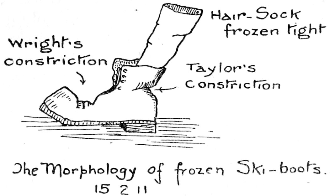
Each morning we had a painful ceremony when it was necessary to don our frozen boots. Remarks more fervid than polite flew about the tent, and some of us found that quotations from the poet philosopher lubricated the process.
“... Gritstone,—gritstone a-crumble:
Clammy squares that sweat, as if the corpse they keep
Were oozing through”
was supposed to be a very potent incantation. We carried no blacking, but this ceremony was called “Browning the Boots.”
Open water washed the face of the Blue Glacier. Black snaky heads—reminding me of prehistoric plesiosaurs—could be seen darting about amid the brash ice. They were Emperor penguins, which swim with their bodies submerged.
To the south of us stretched the sea-ice, which was evidently rotten and ready to move north. Beyond the Blue Glacier on the right stretched a broad fringe of moraine which extended fairly continuously along the north side of the Koettlitz Glacier. Immediately ahead of us was a fifty-foot ice cliff, but some distance to the south we found a lower place and managed with the Alpine rope to lower the sledges down to the sea-ice. We crossed the “pressure ice”— where great cakes had been up-ended to form a frozen rampart—and reached a good sledging surface at last. Near by was a great pool of water containing many seals, where jostling ice pancakes were surging about, so there was obviously no time to 155lose. We pushed gaily south and camped that night in a little gravelly dell among the moraines.
This crater-like dell was occupied by a frozen lakelet of greenish ice, the colour being due to algæ. On the slope above the lake was a blanket of alga forming a sort of peaty layer an inch thick.
The latter was apparently in situ, for it extended uniformly for about ten feet. This occurrence of peat points to an elevated old lake bottom, and we saw similar examples later on our journey. Even in Antarctica at present we see that considerable organic material is deposited, which might form a thin coaly layer in succeeding ages under suitable conditions. Indeed, the kerosene shale deposits of Australia are supposed to originate in some lowly plant-form like these algæ.
February 17, 1911.—We had a calm, clear night, and all slept very well on the soft sand of the moraine crater. Just to northward was a little bay filled with pancake ice having two-feet motion. We made south across little bays over a very good surface, which was intersected by cross-channels of clear ice. Seals were very numerous along this coast. We counted one group of thirty. We could now see the first of the Ice Slabs (described in 1902), which seemed in its lower portion to run parallel to the coast.
Wright espied some white material in the moraines, and we walked across to see this. It turned out to be a huge deposit of Mirabilite (sodium sulphate), about ten feet across and fifty feet long. It was granular in texture, and the dip of the bed was quite high. The Mirabilite was originally a level deposit in a saline lake, so that, just as in the case of the algæ, we have evidence of strong upheaval of the moraine silts, since they experienced a long-continued phase of equilibrium. The granular mass was not unlike rock-salt in appearance.
We proceeded south and crossed the mouth of the large bay marked on the Discovery map. We halted off the southern headland for lunch.
I had a small adventure which might have been serious. On outspanning—which consisted in freeing one’s harness from the sledge—I walked over to look at a seal which had crawled about a hundred feet from the tide crack. He shook his head angrily at me, so that I made a loop on my harness—still attached to my belt—and lassoed him with unexpected ease. 156The seal bolted for the tide crack—and for a short distance they can “lollop along” fairly rapidly. It was amusing, at first, being pulled by an angry seal; but it suddenly struck me, “What will happen when the brute dives into the pool?” I could not get the loop off his neck, and had as much chance of stopping him as a railway train. I experienced some anxious moments before I managed to get ahead of him and jerk off the lasso, for it was impossible to slip out of the broad waistbelt in time. This adventure furnished considerable amusement to my unfeeling comrades, and became the subject of one of Wilson’s sketches in the South Polar Times.
After lunch we took a round of sights from this low headland. It was composed of moraine heaps with numerous circular sheets of water, which reminded one most strongly of crater lakes. On descending from the cape, Debenham found that the steep little cliff near the tide crack was formed of ice covered with a mere veneer of moraine silt. Probably a large portion of the promontory was ice, and we saw other examples of this pseudo-moraine further up the Koettlitz. As Debenham suggested, the crater lakes were due, in all probability, to the melting of the foundation ice. Probably the sun’s rays acting on the silt in a shallow pool have a powerful effect in deepening the lake when it is once initiated. The drainage of such a lake presents some difficulties, for though there was usually an apparent outlet, many were quite enclosed by a circular wall of debris. Steps of silt, appearing as small terraces, were common among the heaps. These probably represent crevasses in the underlying ice, and we actually saw several such crevasses in the ice exposure noted above. Perhaps these crevasses account for the (hidden) drainage, for ablation could not empty many of the lakes. The whole question of the origin of these unusual lakes is of great physiographic interest.
We could see fairly rough ice ahead, but hoped to be able to get the two sledges several miles further before depôting one during our work on the Koettlitz.
We proceeded somewhat to the east over blue ice. This soon became rippled and degenerated rapidly into a fearful “glass-house” and “bottle-glass” surface. We started to fall through the ice into hidden channels, and in some cases there was a foot of fresh water awaiting us. Things got 157worse and worse. We wriggled round ice “mesas” with vertical walls, over huge curved platforms which threw us all together in the centre and then dropped beneath us. We thought it might be better nearer the land, but at last had to lower the sledge down two feet to the lower level, which was silt covered and all the harder to sledge on for that reason. The “mesas” showed three layers. A flat cake of solid ice on top, then a few inches of very much weathered ice, and below a solid pedestal about three feet high. We hoisted the bamboo and flag and spread out to prospect. The ice became worse towards the coast, but Wright reported somewhat better going towards the centre of the gulf. However, it was obviously unwise to drag our unnecessary sledge further, so we turned in our tracks and crossing many “glass-houses” (into most of which we fell, though with little damage) we made for the headland where we had lunched.
It began to snow and looked very threatening around Mount Discovery. There was an ugly luminous patch in the sky to the south-west, and a heavy snow cloud with a very ragged edge. On Erebus alone was a red-gold ray of sunshine. From these portents Evans prophesied a blizzard. We reached land without undue difficulty and crossed the pressure ice, pitching our tent in a dell not unlike our last camp, though it was flatter and more exposed to the east. We carried the smaller sledge well inland, but left the large sledge below on the sea-ice, for we should have had to manœuvre it round an open channel, and we did not need it for laying our depôt here. This channel along the coast was about twenty feet across with a five-knot current in it, which was flowing strongly north. Seals swam up it quite frequently, and often used to halt and observe the strange visitors alongside. While the pemmican was cooking I went on to the ice and killed a seal and extracted his liver.
This camp marked the end of the third week. We celebrated it by eating a pound of mixed chocolates. Wily Evans led us to believe that he was the donor; but as a matter of fact, each sledge had a box of them packed in for birthdays and feastdays.
The snow stopped about 8 p.m., but later in the night a strong wind from the south-east blew much sand on to the tent. We had an argument as to whether this was a blizzard 158or not, for there was no snow in the wind. Personally I now think it tends to prove that the snow in the blizzards is largely old snow caught up again, for the force and direction of the wind were just those of typical blizzards. We were protected from the open barrier surface by Brown Island and the Koettlitz glacier, and this region is one of small snowfall in any case. So we were not inconvenienced by such blizzards as blew on this western coast.
The food was lasting out well. The first tin of biscuits was finished, and had lasted from the 3rd instant. (We had, however, an extra bag of loose biscuits.) I started my week of cooking on the 18th, and as we reached Hut Point in the seventh week I had only one turn at this duty.
February 18, 1911.—It seemed advisable to get a good view of the Koettlitz from some high peak, so I decided to spend a few days in the vicinity of this camp before marching up the big glacier. We had a “make and mend” morning—sadly needed by our boots. I had saved some staples from the venesta boxes (thrown away at Butter Point) and found they were satisfactory in holding the soles together. Luckily the others’ boots were very much better, though Debenham’s were much improved by some of Evans’ sewing. We had a large fry of seal’s liver in butter, and Debenham and myself decided that as raw blubber tasted passably, we would fry liver in blubber for the next meal off seal meat.
In the afternoon Wright and I crossed Davis Bay to the mouth of Hobbs Glacier (about two miles to the north-west). The promontory on which we were camped was about a quarter of a mile across, chiefly built of basalt fragments rich in olivine.
The shore of the bay below Hobbs Glacier was in the form of an extraordinarily flat alluvial fan. This uniform level extended almost to the glacier for three-quarters of a mile, though it narrowed greatly away from the bay. It was mapped out in square “tesselations,” and at the sides were striking terraces about five feet higher with strongly marked, clean cut edges. The whole topography had a very recent appearance; but the only explanation I can give for these levels points to a period when Davis Bay was dammed by ice so as to raise the waterline to the levels of the various terraces. A parallel case of terraces in a waterless region is given in 159Utah, where the hills around the great basin are fringed by similar deposits indicating a bygone lake.
Down the fan ran a creek from the glacier, which cut into the silts at the shore to a depth of several feet. Evidently the base-line has been lowered by this amount since the fan was deposited. From the hill above the bay it could be seen that there were two fans, one of a lighter coloured silt being derived from the next valley to the south. We could also see that our camp was really on an island which corresponded to the stranded moraines south of Butter Point.
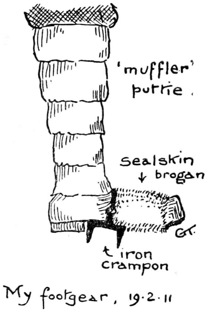
February 19, 1911.—I cut out some sealskin from the carcase near-by to make a pair of “brogans” to cover my boots, lashing them over the sole with yarn, and over the sealskin I bound my iron crampons (steig-eisen) on. Then we all started to explore the valley immediately west of Davis Bay and south of the Hobbs Glacier. Leaving the sea-ice we reached a lighter coloured “fan” by a sharp step of five feet. Emerging through this broad gravel fan were “nunataks” of large stones which had evidently been deposited before the fan. They rose twenty or thirty feet above the fan, forming ridges leading towards the valley. We reached a gully about 500 yards from the bay, which was entirely water-cut, and was fifty feet deep. It had steep sides and its bed sloped considerably. The latter was filled with large rounded boulders, one or two feet in diameter, obviously waterworn. The account of the summer streams in 1903, given by Dr. Wilson, explains this striking example of ordinary water erosion, which I was unprepared to meet in icy Antarctica.
The gully wound about through the morainic foothills, and widened considerably about a mile higher. Here it was occupied by an ice-sheet some 300 feet wide. In this sheet narrow little canyons four feet deep had been cut by the water, and very generally these canyons were roofed with ice. 160In other places the whole ice-shell had been undercut for thirty or forty feet by the relatively warm water.
Gradually the valley—which I named after Professor W. M. Davis—became wider, and a tributary joined it from the north. (See folding map at the end of the volume; and also p. 175, section No. II.) It drained the lowest slopes of the foothills, which extended to the scarp of the Western Mountains. These lowest slopes are largely covered by a gigantic deposit of moraine matter. This deposit extends many miles along the foothills, and can only be due to the great Koettlitz glacier.