III FIRST WESTERN EXPEDITION (continued 2)
Reading edition
Four or five miles from the coast the steep hillsides formed of solid rock rise somewhat abruptly from the moraine slopes to a fairly uniform height of 3000 feet.
The sides of the valley along which we were walking were marked by lateral ridges in several tiers. These were about thirty feet high, and in some cases certainly contained much ice. At one spot the silty covering of the side of one of these lateral ridges was marked by vertical stripes of darker silt, as if the whole ridge had moved slightly and cracked along these lines. These ridges followed the contour of the hill between the tributary and the main valley, and reminded me of the parallel roads of Glenroy (though on a very small scale, of course). They are, I think, like terraces or beach deposits due to a bygone ice dam across the mouth of the main valley, such as one sees in the Märjelen See above Fiesch in Switzerland. Later we saw “pocket editions” on Cape Evans.
Continuing up the valley we found it bounded between solid cliffs of limestone, which were altered in places to a marble. We called these the marble cliffs, and they culminated in a double peak of a fawn tint, which we called Salmon Peak from its colour. I kept along the base of these cliffs while the others walked up the thal-weg 200 feet lower. We soon saw that the upper portion of this “dry” valley was occupied by a glacier whose snout was forty feet high.
Some light snow had fallen lately and occupied the furrows of the “tesselations” which ornamented the floor of the valley. For some reason (probably the direction of the wind and sun’s rays) only the north-south furrows were now filled, 161and these white zigzag markings on the black basalt-debris resembled so many white snakes!
The Davis Glacier snout was about six miles from the sea. A range of mountains 4000 feet high blocked the upper end of the ᑌ-shaped valley. I was very anxious to see whether the glacier really came into the valley from some hidden angle, for if not this glacier was of great interest. Here was a glacier which could not be more than eight miles long, which had cut out a valley 3000 feet deep and a mile or so broad.
We separated here, Wright and the others taking the theodolite up a 3000 feet hill to the south, while I went a couple of miles further into the range to see the head of the glacier.
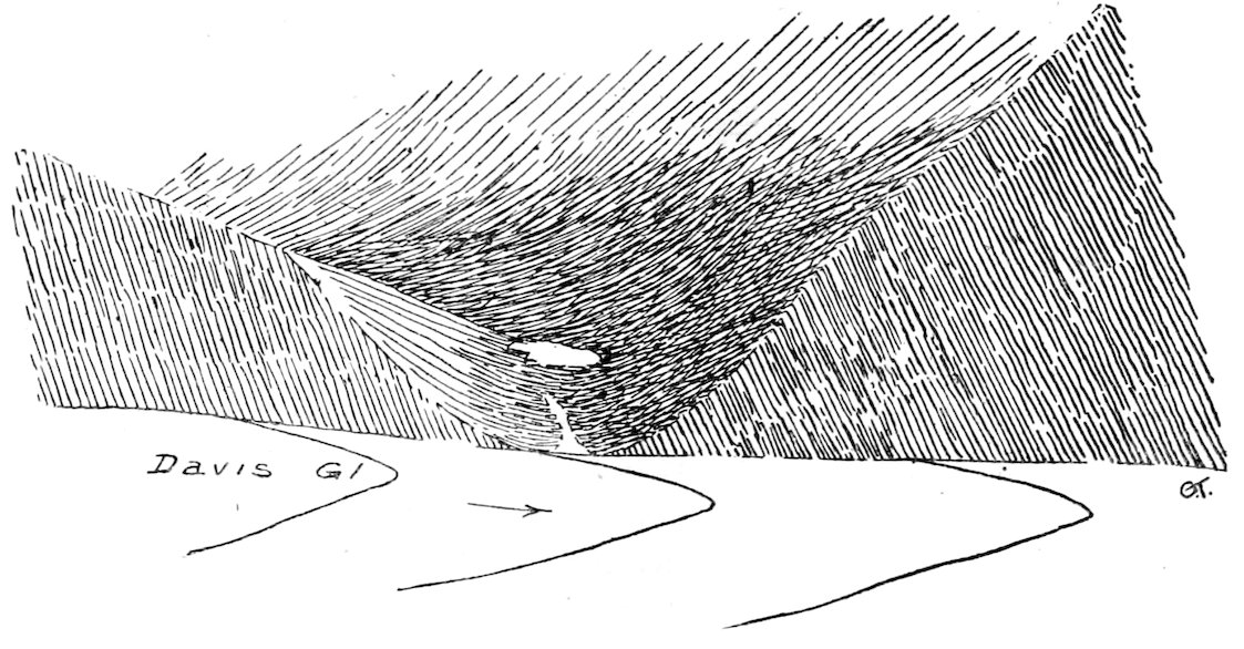
Empty hanging valley, on north wall of the Davis Glacier, showing catenary curve due to former glaciation, February 19, 1911.
Everywhere were the signs of recent recession of the Davis Glacier. First I had to cross the mouth of a side valley opening 600 feet above the glacier. This was quite free from ice, and was a perfect “bowl-valley” or cwm. On the opposite side was another “hanging valley” at a lower elevation, with a most symmetrical ᑌ-cross section. It was abruptly truncated by the plane surface (35°) of the marble cliffs under Salmon Peak. I now climbed round the top of a cliff of ice which descended smoothly for 1000 feet to the glacier at an angle of 30°. After ascending over many outcrops of limestone schist, granite, and basic dykes, I reached the head of the glacier and saw that it originated in a cwm about three 162miles from its snout. Its snowfield was very circumscribed, but reached the summit of the bounding ridge in several places. The glacier up here was not crevassed, and the main surface lay only two hundred feet below me. After making some rapid sketches I returned to the snout of the glacier where the others had already arrived.
This Davis valley contains a typical example of the “ice-slabs” mentioned by Ferrar. But I do not agree with his description of them. He writes, “They are the relics of glaciers which once drained the snow valley; but owing to diminution of ice-supply, this has now become an inland basin, and its overflows have slipped away from it, leaving a subsidiary watershed bare.”
In the first place, the head of this glacier was a typical cwm, with steeply sloping sides, and to all appearance a sharp crest to the ridge at the back. It did not resemble the discontinuous lower portions of the Lacroix and Sollas Glaciers in Dry Valley, which fully deserve the title of ice-slabs. The latter lie supinely, one might say, on a gently sloping hillside, in which they have cut no definite trough. The method of erosion of these curious valleys became clearer to me as we saw other examples in the next fortnight.
Monday, February 20.—We spent the morning making a depôt on the Ice-Borne Moraines. We left the camera legs with a flag thereon, and cemented them into the gravel by the simple method of pouring a cup of water on to it! The seal’s liver we put under the food stacked in the small sledge, and I left a note of our whereabouts in the instrument box. We took eighteen days’ food with us.
We crossed about one mile of good surface and then reached “glass-houses,” “craters,” “pools,” etc., through which we struggled till two o’clock. After lunch Wright and I prospected and found some “plough-share” ice about a mile to the south-east. We made for this, having to cut tracks along the bottom of the channels connecting “glass-house” areas. Debenham and I pulled on short traces while the others lifted the sledge over the constant succession of obstacles. The sledge fell two feet into a hole and capsized, but the brunt of the shock was absorbed by the empty oil tins. We were always falling, and occasionally disappeared a foot below the glass-house surface.
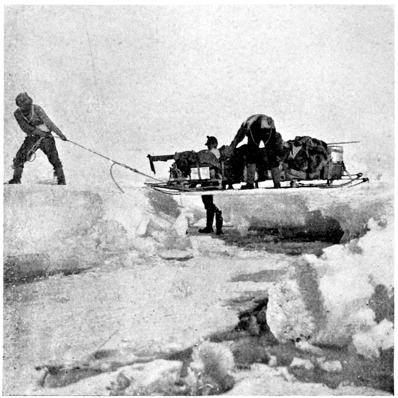
TRYING TIMES ON THE KOETTLITZ GLACIER, Feb. 2, 1911. The sledge has fallen through “glass-house” ice into a thaw water channel.
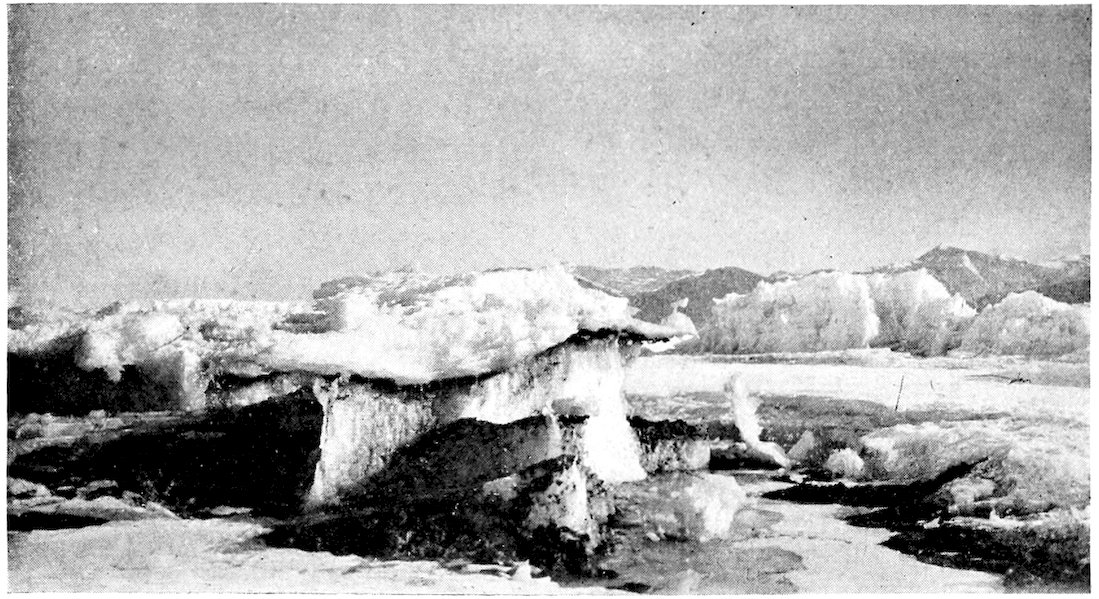
TABLES OR ICE “MESAS” IN THE LOWER KOETTLITZ CUT OUT BY THAW-WATER. [See p. 157.
163Later we halted in a slight snowstorm. We were cheered to hear Evans say that it was the worst sledging surface he had ever seen, even though he added that it was not fit for sledges. I wore my iron steig-eisen all day, and so was able to hold my own somewhat; but the others preferred to slip about, for the irons certainly made one’s feet very sore.
For an hour we had fair going over “plough-share” and shallow glass-houses, during which we changed direction somewhat to the south. A thick snowstorm blotted all ahead, and we reached a region of “basket-work” ice structures, which we called “fascines,” and all sorts of ice tables. One shaped like an Armadillo standing on a pedestal was especially noticeable, and after pulling the sledge over three “roof-pillars” (the roof having long ago fallen in) we cried “enough,” and camped in the shadow of the “Armadillo.”
“It is fairly warm to-night, the others smoking peacefully. They have almost given up trying to make me smoke. I had a difficulty in getting Wright to eat some extra pemmican! ‘Sugar Vat,’ ‘Liver Chewer,’ and ‘Pemmican Tub,’ are common ekenames. And so to sleep.”
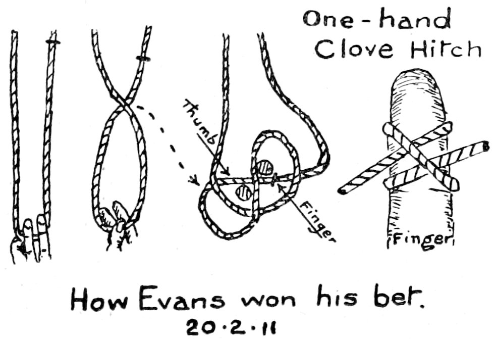
During the next four days we struggled up the middle of the Koettlitz Glacier. It was a strenuous time, but I recall a pleasant noon halt when P.O. Evans earned an honest penny. We saw him playing with the rope which lashed his sleeping-bag. Says Evans, “I’ll show you how to make a clove-hitch with one hand, and I bet you a 1s. 3d. dinner (our usual currency) you can’t do it after you’ve seen me do it six times!” Debenham took the bet, and we all watched Evans closely. Then “Deb” tried, and to our joy succeeded, for the handy-man was rarely “done.” But he never turned a hair, and booked the bets that now filled the air. Again Debenham proceeded to try, and failed—and Wright and I were equally unsuccessful. Evans made quite a haul, but 164after saying he had never seen any one do it by sheer luck before, he proceeded to teach us the dodge; and later Debenham became quite a knot-master under his willing tuition.
“A fine sunny morning, the first for many days. Even this scene of desolation looks cheerful.” Thus my sledge diary for the 21st. But the route did not improve. I wrote: “We got going on awful stuff—rounded pools of ice, between tables. It got worse and worse, and after many bumps and leaps and falls I decided to prospect. We had done half a mile in the hour.... We started again about 3 p.m. Awful heavy work over ‘glass-house’ and leaping three-foot chasms, between high fascines and across decomposing rivers of ice.”
About 4.30 we saw a ragged piece of skin projecting from under an ice-table, and found that it was part of a large fish. We spent half an hour chipping it out, and recovered the dorsal spines, skin, tail, and the vertebræ. These were preserved in a yellow fatty substance smelling like vaseline and quite soft. I made rather a ludicrous mistake here. I carefully preserved a very hard irregular mass coated with this flesh, thinking it was a bone, but later, after we had carried it for days on the sledge, we found that this “pelvic bone,” as we called it—melted in warm water! No head was found, and in this respect the fish—which was possibly about four feet long—agrees with the four large headless fish found by the Discovery Expedition. We had a hot discussion in the hut as to this problem of decapitation, but came to no definite conclusion, for it seemed too far for seals to carry it.
That night we slept at Park Lane Camp. We had been traversing a frozen park, set out in circular beds with winding paths in every direction. The “flower-beds” were represented by elevated masses of ice thirty feet across, exactly like an apple pie with a raised crust—even to the four cuts made by the housewife across the top! The last two days we had only progressed seven miles, and for five of them we had carried the sledge rather than dragged it.
Next day, however, we found that to the south the glacier was nearly continuous. It had not been dissected by thaw waters to nearly the same extent, and by 4 p.m. we managed to advance ten miles to the south-west. We camped on a platform of weathered ice, so rotten that it resembled a layer 165of honeycomb. We found that this honeycomb ice was very common in this part of the Koettlitz.
We tried to find an easier way out of the numerous undulations which now characterized the surface, but unsuccessfully, and so plugged on south-west. We used to “pully-haul” up one side (i.e. hand over hand) and then toboggan down the other. P.O. Evans was an expert steersman, while we others used to keep the ropes clear. But we had some nasty falls, especially Evans, who got a cut deep in his palm from a piece of “bottle-glass” ice, in spite of his thick mits.
At noon we came across a picturesque tunnel in the ice, about three feet wide, seven feet high, and one hundred feet long. It had been cut out by thaw waters which had now drained away.
In and out wound the lanes, forming a regular network through all sorts of picturesque pinnacles. Here was one like a yacht on stocks, there a perfect wedding-cake twelve feet high, again a lady’s bonnet, and so on, in infinite variety.
The long promontories of “bastions” along which we skirted are probably dissected undulations of the original glacier surface, fifty to a hundred feet high. They are all steep to the north, and covered with sloping plough-shares on the south. The bergs which we left ten miles back were like jumbled blocks, and were not separated by simple channels—which looks as if they had been floating separately at some period and then frozen together again. This may explain the presence of the sponges and fish which we found so far from any open water.
On the 24th I wrote: “This is the day of my release from the joys of cooking! We have done four weeks. A rotten night, cold, and pillow (of books, etc.) slipping away on the smooth surface. Every one restless. Smooth ice no good to sleep on, though I had a jersey under me. Bright next morning, and we took photos till 10 a.m. Then we made across country towards a hanging valley. Some of the lanes were overhanging, and I took a photo of Debenham and Evans sitting under a ledge. Sheets of plate-glass projecting from low bastions were common, but there was no undulating country. More common were sharp bottle-glass angles sticking up abominably from about eighteen inches to 166two feet, and impeding the sledges, while pot-holes (due to the sun eating round black silt) caught one’s boots.
“Lunched in this mullock about two and a half miles from the coast. Then on practically straight, making fair progress with Evans and C. S. W. at the sledge, lifting while we pulled. We had several upsets, and the rucksack was jerked off, but the fossil fish has survived so far.
“After a final dash up over steep silt-bank between pinnacle ridges (where the sledge balanced rockingly!) we reached a broad avenue between moraines and Stonehenge pinnacles of ice. I went back for my brogans, and fell a frightful ‘cropper,’ getting a spike in my fifth rib.
“After half an hour or so we plugged on steadily up a beautiful surface for two and a half miles. The moraines were getting bigger and wider, and were now about three hundred yards across. We finally reached a fifty feet silt ‘col,’ and had to portage the sledge. It was mighty heavy, and flattened our crampons. Later we reached a cul-de-sac among the moraines, and after a survey I decided to make a final camp, as we were now favourably situated to explore ‘Snow Valley’ and Heald’s Island. I don’t understand the ice-slabs or the promontory on the 1902 map. I guess it is wrong.
“The sun clouded and snow began. We put the tent in a sandy dell. It was so small that we had the tent like an old sock at the side! However, we are on earth again, and not on cold wet ice, even if one post of the tent is on a huge stone.
“I cooked my last meal. Raisins in excess (× 2), sugardust about right, cocoa × 2, chocolate short ¾, cornflour three portions left, cheese short ¾, biscuits right, and pemmican two feeds left. Butter short owing to seal-liver feast. We had a good hoosh and drank thick chocolate.
“My week’s cooking done, Praise Be! 9.20, snowing now and pretty cool.”
Next morning was devoted to a “make and mend.” All our sleeping-bags and finnesko were wet with the sloppy icefloors of the last week—for we had not been able to find any snowdrifts on which to camp. They are much warmer and drier than ice.
Behind the tent to the north were slopes about 1000 feet 167high leading to empty “hanging” valleys. These radiated from the base of the Lister scarp, which rose in one steep face 10,000 feet to the summit. This face was pitted by gigantic “armchair” valleys or, as they are technically called, cwms, and presented a spectacle which probably could be paralleled nowhere in the world.
Looking southward across the Koettlitz from the mouth of one of these hanging valleys one could see some sort of plan in the icy maze which had so bewildered us. Above Heald Island the valley was filled with the glacial stream in a normal uniform mass, interrupted only by crevasses and falls. But to the east of Heald Island it took the form of a glacier “delta.” Below the falls the ice descended to the east in a series of broad undulations, a portion of which we had traversed on the 23rd. Long promontories of ice fifty feet high extended from the unbroken glacier mass and probably represented the crests of the undulations. These degenerated at the ends into icebergs and monoliths of ice, and these again had weathered into the bastions and pinnacles. Lower down the thaw waters had etched these into still smaller units, and along the coast just below me the streams had formed a well-defined if narrow avenue of smooth ice, which promised us an easier return.
On these slopes I found an ice-scratched block—the only specimen I had seen in a hundred miles of moraine debris.
I walked along the margin of the glacier, and was amazed to see seal-tracks in the fresh snow. We were over twenty miles from the sea, and had not seen any possible route for seals on our outward journey. Yet here were two seals—asleep as usual—on the old glacier ice. I disturbed one of them to see what it would do. He sneezed and grunted at me. When I teased him further he began to warble! I heaved a lump of ice at him, whereupon he lolloped twenty yards to a wet patch, lay over on his side, and produced a whole octave of musical notes from his chest, ranging up to a canary-like chirrup. Finally he crawled under a deep ledge, and vigorously butting with his shoulders, opened out a hole and flopped under the avenue ice.
Later I came out among the moraines, and was unable to make out where our tent was. Soon I saw Wright’s footprints in the snow—two sets, one going each way. By 168Sherlockian logic, I decided to follow the shorter-pace footsteps, judging that the weary owner would walk with less “vim” returning, and they seemed to be “slurred” also. Finally, a mile ahead I saw some skua gulls wheeling about, and sure enough below them I found our tent.
When I reached camp I found that Wright and Debenham had both met parties of seals. We all thought of the constant stream along the tide crack by our last depôt, and came to the conclusion that this was largely fresh water, and formed the main drainage of the Upper Koettlitz. By this sub-glacial stream the seals penetrated nearly thirty miles inland up the Koettlitz Glacier.
February 26, 1911.—It seemed advisable to take the sledge as far up the Koettlitz as we could without waste of time. So we portaged all our loads out of the cul-de-sac over a moraine col and so reached the outer margin of the low-level moraine, where another avenue of smooth ice ran parallel to the Grand Canal which we had been using. About two miles to the west we passed a seal and its hole. Soon the pinnacle ice came in so close that there was barely room to squeeze in between it and the moraine. We had one spill within a few yards of our final camp, and unfortunately it resulted in the destruction of the focussing screen of my camera. In a sheltered bay among the moraine heaps we pitched our furthest camp, where we remained four days.
About 2.30 we started for Heald Island, which lay three miles to the south across a tumbled sea of ice practically impassable for sledges. (This island is placed too far to the south on the Discovery Map.)
First we crossed the definite line of high pinnacles which extended almost continuously for twenty miles parallel to the coast. This we called Stonehenge structure, for many ice masses strongly recalled the Druid monoliths. Then over a comparatively level area of honeycomb ice between low bastions. Finally we reached wide level lanes with a thirty foot wall on the side facing the sun, while the opposite wall sloped much more gently and was fretted into plough-shares.
Looking back towards our camp we were facing north towards the sun, so that we saw the sheltered side of the moraine heaps. The whole surface seemed to be snow-covered. Yet from the opposite aspect the moraines seemed 169to be bare. I expected this constant thawing on one side of the moraines would have resulted in some asymmetry in their shape, but I was not able to detect any such characteristic.
We had not much difficulty in traversing these lanes, and crossed several cols, down which Debenham and I—who were not wearing crampons—had to slide in somewhat undignified positions. Here we separated, Wright and Evans making for the lateral gully north of the island, while we moved more directly for its eastern face. We had been steadily rising up the lanes and came to the divide near to Heald Island. Here a narrow water-cut channel led down to a broad frozen river 100 yards across, which fringed the island on the east.
Debenham collected along the slopes while I pushed on to get a summit view. This end of Heald Island was 1100 feet high, and the slope was very steep, for the most part reaching 30°. It was covered with a talus of schists, limestones, and basalt, the latter being erratic, while the former were in situ on the top of the hill.
I got good views of the topography from the comparatively flat top of the island. The surface was scraped fairly smooth by glacial action, and only a thin veneer of basalt rubble was present in this eastern portion.
I carefully noted the features towards the S.W., and was satisfied that the slope glaciers (Walcott, Ward, etc.) headed in sharp ranges 6000 feet high, which joined to the scarp of Lister without any intermediate longitudinal valley, such as was indicated on the 1902 map as “Snow Valley.” The surface of the glacier through which we had passed was very interesting. I could now see that it would take days to get the sledge up the glacier to a spot where our view would be materially increased, and judged it better to investigate fairly fully the features in this interesting region of the valley.
The island evidently blocked the glacier greatly, for this was 700 feet higher on the south-west face than where we had crossed it.
Next morning was foggy and cold, and there had been snow in the night. We boiled the hypsometer and found that the camp was only 100 feet above sea-level. At 11 a.m. we started off to explore a large tributary glacier which we could see across the low-level moraine. Debenham had a sore heel, due to the deep ridges which developed in our frozen 170ski-boots, so that he did not move far afield for the next day or two.
After crossing two miles of moraines we reached a lake. It was drained by a stream which ultimately reached the pinnacles of the Koettlitz glacier.
Between the ice cliffs and the lake this stream for a considerable distance flowed under the moraine, and ultimately entered the seals’ sub-glacial stream and so reached the sea. Coleridge’s lines entered one’s mind:
“Where Alph the sacred river ran
Through caverns measureless to man
Down to a sunless sea.”
So we christened this stream the Alph River.
We marched along the lake and up the gully beyond. Here a tributary entered from a large cave in the moraine wall to the north. The roof of this cave was coated with most beautiful ice crystals, which resembled pine twigs in shape and were about two inches long. Many brownish ice stalactites and stalagmites fringed the walls of the cave, and Wright was lucky in obtaining some beautiful photos of these structures.
At 4 p.m. we reached our goal—the steep face of the Walcott glacier, but as the weather looked stormy we had to retreat immediately. Wright and I compared compass readings here. The needles swung extremely sluggishly, but we found they were reliable to four degrees—which is about eight times the ordinary error. The fact that magnetic south was nearly due north also complicated matters here! We marched back by a different route and discovered a strong outcrop of basic lava about fifty feet thick, which was rich in olivine and had caught up fragments of garnet rock in its passage through the earth’s crust.
It was a cold cloudy morning on the 27th when we started off for a tramp over the ancient low-level moraines. We could see a big tributary glacier about twelve miles away, whose vertical front was separated from the Koettlitz by two miles of bare moraine heaps. Debenham, with his bad heel, stayed around the camp where there was plenty of collecting.
We went a short distance along one of the moraine avenues. Then we climbed eighty feet up and proceeded 171over the more or less level moraine debris for two miles. There we came on an interesting outcrop. It was very unexpected to find a deep gully 100 feet below the general surface with water still flowing in the creek at the bottom. The walls were largely composed of ice hereabouts, and they were melting merrily in the sun.
This stream originated in the lake which we had seen a day or two before, and we reached it viâ some beautiful meanders. At its outlet was a cave twenty feet deep cut in blue ice.
Evans and I had a bet as to the length of the lake, in which I recorded a win; but “Taff” usually came off best in these encounters!
February 28, 1911.—We awoke to foggy and cold weather, which was unsatisfactory, as one of our chief objects was to climb a peak and get a good view of the hypothetical Snow Valley (between Descent Pass and the Walcott Glacier). Wright and I went back to Alph Lake some miles to the west, while Evans and Debenham made another journey to Heald Island and traversed it almost to its western end.
I investigated the cave in the silts at the lake outlet. The cave seemed to be due to a block of ice breaking away at a silt band, for the roof was filled with stones, while the mass above was clear ice. The interest lies in the fact that these silts were obviously laid down in water, and the large boulders arranged in uniform layers indicated that a strong current had been operating.
I left Wright at the lake, which he crossed later to examine the “crystal cave” we had seen previously. Meanwhile I climbed up the steep delta of the stream leading to the “Ward Hanger,” and visited the latter valley.
This gully was about a mile long with steep sides sloping thirty degrees at first. I made for a black exposure which I could see ahead where the gully cascaded down from the hanging valley. This was a bed of decomposed basic lava, about twelve feet thick and pointing to fairly late volcanic action.
Then I proceeded up the gully, scrambling over large rounded boulders. I hurried to the top of the slope and found that a very definite dam blocked the hanger, just as in the adjacent valley. These dams were, I think, high-level 172lateral moraines left by the Koettlitz glacier, and not terminal moraines of the small tributary glaciers. I could see that the latter (Ward) glacier now lay about five miles up the valley, and resembled the others which we had observed previously.
Wright and I then traced the Alph River from the lake down to the glacier opposite Heald Island. We had to climb over several rough barriers of silt-coated ice, under which the stream flowed. The relative movement of the frozen surface and overhanging ice cliffs led to very queer twists and bends in numerous icicles, thus forming a striking example of the plasticity of ice.
The water was flowing strongly with musical gurgles under a lacework of crystal-edged ice. We got very wet boots by slipping through on our walk at the foot of the steep slopes fifty feet high. The river ended in a little round lake separated from the Koettlitz by the silt-covered pinnacle described previously.
We walked along the glacier edge towards the camp. At one spot the water was welling up through holes in the ice, and appeared to indicate a slight tide, for it had spread out to varying boundaries at various times. Probably a variation in temperature would account fully for the difference in supply.
We reached the tent about a quarter past six.
The weather had been dull, and it was useless to expect a good view of the western scarp and valleys. I decided to wait until the 3rd if necessary to climb up for this view. The hills were now snow-covered, and we had several valleys to the north to investigate before our return.
The month of March opened with a bright sunny morning, just suited for our proposed climb up one of the hinterland ranges. We climbed up the slope about eight hundred feet and soon reached the level floor of the hanging “valley” just behind the camp. We marched along this to the north end of the valley towards a prominent peak on the eastern ridge. A stiff climb over snow slopes and rugged granite led to the summit, which we reached at 1 p.m. The aneroid made this 3000 feet above sea-level. It was a beautiful day and we could see Erebus, Discovery, Morning, and the Pyramid up the Koettlitz. Lister itself, as usual, was in the clouds, but nearly all below was visible. We could see numerous hinterland ridges reaching from the Lower Koettlitz to the Lister 173scarp, and satisfied ourselves that no lateral “Snow Valley” existed below the scarp such as has been indicated in earlier maps.
It was very cold on this hill (which we called Terminus Mountain); and after swinging the theodolite and taking several photographs we hurried back to the tent down Ward Valley.
On March 2 we started our homeward trek; nothing could be worse than our outward track up the middle of the glacier—though we were able to study the changes of the glacier ice and so did not regret it. I therefore decided to hug the coast on our return, though near the depôt the ice was so full of silt from the moraines that we had not seen any feasible route along the coast thereabouts.
For the next few days we followed the course of the sub-glacial Alph River. Some four miles down-stream from Terminus Camp a rampart of ice pinnacles commenced, which recalled the monoliths of Stonehenge. These walled off the rough sea of the Koettlitz Glacier from the frozen surface of the “river.” This broad lane was here a quarter of a mile wide and consisted of a level surface broken up by deep sunken “paths.” The more elevated areas were preferable for sledging, for the paths occasionally let us through into water. The whole structure was due to the drainage of water away from rivers and lakelets whose surface had frozen.
This splendid track—which we called “Alph Avenue”—enabled us to proceed with unexpected ease, and each day we halted and explored one of the numerous tributary valleys which characterized the hinterland.
Each valley was of the same type. A great bar of debris, some three hundred feet high, blocked the mouth of the tributary. Within this was a bare rounded valley extending to the foot of Lister. Some five miles from the coast was the snout of a tributary glacier which had originally deposited the moraine, but now was shrunk back to a mere shadow of its former self.
All along our route were groups of seals, and numerous skua gulls enlivened the surroundings. Coming back from one of our détours I was much amused to see Wright crawling about among the seals in his investigation of the ice—while thirty skuas were anxiously awaiting the demise of this obviously crazy seal!
174The summer was over now and we were getting fifty degrees of frost in the nights. The weather was gloomy, the sun rarely appearing till it had sunk below the level of the pall of stratus.
We had an eventful lunch just before reaching our depôt. We pitched the tent and fastened the door to keep out the wind. I was sitting next tothe door with my precious lumps of sugar on the floorcloth when I noticed that water was creeping into the tent. In a few seconds it was several inches deep. We bolted our raisins, pocketed the lumps of butter and sugar and rushed out with the sleeping-bags. There was a small lake all round us, rapidly rising round sledge and tent. The water was rushing out of a crack one hundred yards below us, probably driven back by a high tide. We had quite a pilgrimage to get our sledge packed again, having to walk round the newly formed bay.
The avenue petered out here, after furnishing us with a magnificent highway for twenty miles. We had some pretty rough work for the next mile or so, but reached our depôt safely on the evening of the 5th.
Having now described many of the glacial valleys it is interesting to see if we can discover how their peculiar topographies have arisen. One great problem confronting geologists is to explain how the giant “steps” and “basins” of the Swiss glacier valleys were produced. In Antarctica the gradual change in the character of the valleys as we proceed northward from Mount Discovery has led me to put forward a theory which I think holds good for these huge glaciers in latitude 78° S., and may help to explain those in 45° N.
In old Greek manuscripts one can sometimes discern traces of an older script half obliterated by the later writings—this MS. is called a palimpsest. Just so in Antarctica—I think that beneath the largest outlet glaciers, such as the Ferrar and Taylor Glaciers, we can perceive the relics of an earlier cwm erosion.
175
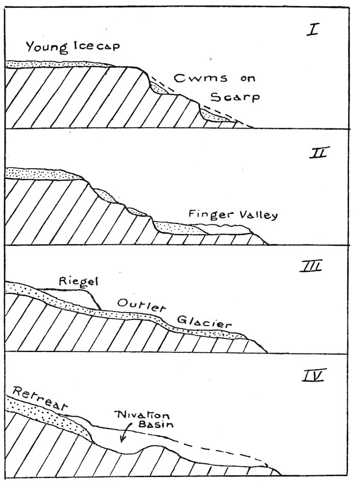
The “Palimpsest” theory. Generalised sketch sections, showing the chief types of valley erosion. I. Early erosion like that shown by Walcott Glacier, 78° 10′ S. II. Headward erosion producing a “finger” valley, shown by Davis Glacier, 78° S. III. Plateau ice overwhelming the cwm glaciers giving profile like the Ferrar Glacier, 77° 40′ S. IV. Pronounced erosion by “thaw and freeze” (= nivation), as shown in the Taylor Valley, 77° 30′ S.
Near Heald Island is the gigantic scarp of the Royal Society Range 10,000 feet high. Cutting into its face are simple cwm glaciers such as the Walcott glacier. This stage is shown in section I. As the snow accumulates (and turns into ice in situ) we get a gnawing process, in the moat, etc., at the margin of the glacier, which gradually extends backwards and eats out a long parallel valley such as the Davis Valley (section II). If the plateau ice-cap increases sufficiently it will drain to the sea as an outlet glacier. This will obviously tend to follow the lowest contours and so would naturally overwhelm a series of cwm glaciers (such as shown in II). Hence we get a glacier falling over steps (and cutting gradually 176through them) which were originally heads of cwm valleys (see section III). Finally, these big glaciers may retreat very slowly, and at their snouts—in a somewhat complicated way which I have explained elsewhere—further erosion by nivation will produce basins with level bottoms, such as those in the Taylor Valley[2] (section IV). In the maximum of glacier flow (for which we have to go to temperate climes for good examples) there is much “planing” by the glacier, but not in Antarctica under the present conditions. At any rate, the conclusion I have reached after two summers’ sledging, is that considerable frost, wind, and water action is occurring in the Ross Sea area, and very little true glacier erosion. Moreover, the gradual succession of types of valley erosion which we investigated makes me confident that some such cycle of evolution as sketched above is not only possible, but has taken place in the south.
On arrival we swept the snow from our old ground and camped on the bare gravel, for our floorcloth was quite soaked. I went over to the seal I had killed a fortnight earlier and managed to cut through the frozen hide. Evans and I then managed to prize off some blubber with the spade. The blubber was quite soft where it was protected from the air. Evans and Wright were frankly sceptical as to the value of blubber as a means of frying!
“After cleaning out the aluminium base of the cooker, Debenham cut the blubber into strips and heated it up. It soon began to melt and gave off much steam at first. The smell was like fried herrings and not unpleasant! We had thawed out some liver from my cache, and at +2° F. it was as hard as iron! I cut it into strips and we cooked it in the blubber for a quarter of an hour or so. Debenham tasted it, and then I ate the first piece.
“Jolly good! Absolutely no taste of fish or oil, which was curious in view of the smell of herrings. Evans took his bit gingerly, and then handsomely acknowledged that he had been sold. He reckoned their 177cook had tried to poison them in 1902. We used safety pins as forks, and my bowie knife to turn it over. A vote of thanks to Deb was passed by the company!
“With luck we shall camp in the middle of the Dailey Isles to-morrow (Monday). On Wednesday get to Hut Point, and then two days to Cape Evans.”
This prophecy was rather feeble! We took nine days to reach Hut Point, and five weeks elapsed before we saw our own headquarters!
March 6, 1911 (Monday).—A fairly sunny morning with a temperature of −8° at 9.30. We spent some time in packing all our depôted goods. I carried an empty biscuit tin to the nearest large moraine heap, and buried it halfway in the gravel with a note of our journey. The sun, glancing on the bright metal surface, made this a very distinct landmark some distance from the moraines.
We had now two sledges to pull, but the surface was very good. We made for the nearest Dailey Island. After one and a half hours we reached old ice at a higher level than the sea-ice we had just left. Here I mounted a hummock and saw that open water extended to Davis Bay, and was practically within one mile of our track. We were rather astonished, for this ice (around Blue Glacier) had not been out for several years. We pushed on and camped two and a half miles from West Dailey Isle for lunch. Another two miles brought us to a most interesting locality. All around us were heaps of large sponges half buried in snow and ice. The three largest heaps were about 8 feet long and one and a half feet high. The sponges were a foot in diameter, and among the long spicules we found Bryozoa, Brachiopoda, Serpulæ, Molluscs, and a fine solitary coral.
How did these marine animals come to be entangled in the old ice on which we found them? The ice was apparently normal fresh-water glacier-ice, but may have been originally sea-ice from which the salt had drained out. At any rate, it was floating—for half a mile further east was a succession of grinding ice-cracks. I believe the sponges were pushed up (from a depth of twenty feet or so below water) by the edge of the Koettlitz glacier, in some palæocrystic age when its snout was much less advanced.
We pushed on about a quarter of a mile, and reached 178irregular ice crossed by a deep gully due to tide cracks. Here we left the sledges, and all climbed up the West Dailey Island. We attacked the nearest snow-covered slope, though later we found it was the steepest portion of the island. There was a fair route along the snow, however, and we soon reached the top. Two asymmetric valleys crossed the island, whose cross section seemed to indicate glacial erosion from the south-east. Blocks of marble, kenyte, and gneiss were scattered over the island, which was itself composed of basic lava. We were most interested, however, in the view towards Erebus, for we hoped to see a clear route to Cape Evans.
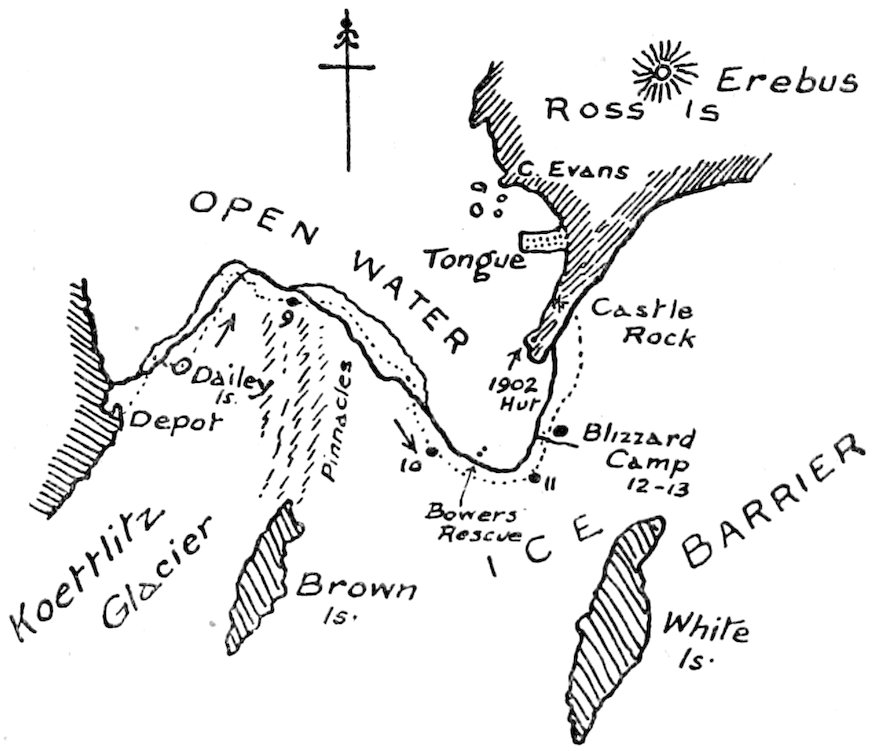
Map showing our journey round the breaking barrier.
Four miles north of us was a prominent crack leading east and west. All the ice to the east and north-east was rough, pinnacled stuff as far as we could see. In the distance Inaccessible and Tent Islands appeared clearly, and also a curtain of frost smoke. We could not detect the latter much south of Tent Island, and hoped this meant that the ice had not gone out behind Glacier Tongue.
1 decided to camp after another mile, and then skirt along the pinnacle (bearing towards Cape Royds) until it appeared feasible to cross to the east. I photographed the little valleys on the island, and then we returned down a much easier slope 179to sea-level. Here we saw a young skua practising its first flights under the eye of two older birds.
We camped in the snow amid troubled ice just off the north-east corner of West Dailey Island.
March 7, 1911.—We had a wakeful night, for the pressure ice at 2.30 started groaning and creaking just under our heads. We had a temperature of −13°, and the night was quite dark, though a glow was apparent to the south. In the morning a cold wind from the south-east arose.
I had to prospect across half a mile of bad surface, but found a fair route for a single sledge before the packing was concluded. The sledges stuck badly on sharp snags, and we had to relay through tables and over snow-covered ledges and crevices. Then we reached a glass-house surface, which was fairly stable owing to the thick covering of snow. We held along the west side of the broad tongue of bad ice and made fair progress. It was pretty cold, however, and Debenham suffered two frostbitten toes.
About 4.30 I felt that we ought to be near the end of the Pinnacle Ice as shown on the map. So we pulled towards it, and reached high ridges rather suddenly. We camped here, and Wright and I penetrated the ice for a mile, making for a specially high pyramid. The surface was frightful, consisting of big rough undulations much broken into snags and pyramids, and crossed by frozen rivers with window-glass buried in snowdrifts. We could see no difference in the distant east. It was evident that we could not cross here, and must make still farther north. We felt that the whole broad tongue had moved north. It was necessary, therefore, to turn back and go rather to the north-west. Hence we called this Keerweer Camp, after the Cape Keerweer where the old Dutch captain retreated from Australia.
March 8, 1911.—We moved off along the edge of the pinnacle to the north. We did about one and a half miles, and got bogged in bad country. A prospect ahead showed that we had entered a sort of cul-de-sac. We could see frost smoke rising all around us, and heard seals; and, apparently, orcas blowing and grunting, much closer than we could explain, for we could see no water. Finally, we decided to keep to the smoother ice, and so for the next mile or so were heading for Butter Point, directly away from our destination at Hut 180Point. Soon we turned more to the east, and topping a small rise, were confronted by a large bay of open water in the pinnacle ice, in which several orcas were apparently enjoying our discomfiture. The water lay right across our path, and we made as rapid a course as we could lay for the further side of the bay.
Before going many yards into the pinnacle ice we came on a labyrinthic river of salt water fifty feet or so below the general level of the pinnacle. Luckily the pancake had jammed in this valley, and it was strong enough to carry the sledges. We had to haul up the sledges by hand on the further (southern) side. Here we lunched, and soon after came to a fifteen-foot drop, which necessitated casting off one sledge. I prospected ahead, and the other three followed almost as quickly as I could pick out a feasible route. Every now and again I climbed a pinnacle, and got a fair view, and so we got along much more easily than I had anticipated.
The grade was good, but necessitated much winding about, and very often drifts of sand covered the ice and played havoc with the runners. The drifts of snow, eighteen inches deep, were no trouble compared with a thin film of sand on an ice ridge.
We could hardly get a fragment of ice hereabouts which was not full of sponge spicules, which did not improve the hoosh. It was very curious to see the skuas pecking at the numerous sponges lying around, while they neglected the small frozen fish (Notothenia), of which I saw a dozen!
By six o’clock we brought up our second sledge to the site I had chosen for a camp. Just north of the camp was a large cavern excavated in the side of a thirty foot cliff by a meandering river, now frozen. We had a fairly sheltered position for the tent, but there was no snow for the flaps. However, ice blocks made that all secure. Before turning in we took a round of angles, which should fix the position of the edge of the open water quite accurately.
March 9, 1911.—A comfortable night, the temperature only falling to −3°. We picked a pretty fair route across the meandering gully. At one place a snowdrift had built up a track above the undercut edge of the river. Then we went down-stream a quarter of a mile, and then hauled the sledges up the further bank. We could see quite a large 181patch of smooth snow towards Observation Hill, and made in this direction. As we were not more than sixty feet above sea-level, I judged this to be four miles off, which turned out to be the case, though it took us nearly two days to reach it.
We pulled in relays, doing one and a quarter miles with the light sledge in less than an hour, and then returning for the heavy sledge with some knowledge of the conditions ahead. Twenty-five minutes took us back to the other sledge, and sixty-five minutes more with the heavy sledge brought our whole equipment one and a quarter miles nearer Hut Point.
Bad sandy patches still annoyed us, but the ice was gradually becoming more level as we penetrated further south. In the afternoon we did a longer relay, with less sand but more snow. We had to cross several creeks, and had some upsets, but at the end of our day’s work a climb to a pinnacle showed up smooth sea-ice no great distance ahead in the direction of Tent Island. Six hours’ hard work—largely hand-hauling—had only given us three miles of progress. However, we were able to enjoy the chocolate provided by Evans in honour of his own birthday, and we christened the camp Birthday Camp in consequence.
I feel that I cannot more fittingly describe the last few days of our First Journey than by transcribing my sledge diary. The style is “choppy,” but if the reader will picture the conditions under which the journal was written he will perhaps excuse lapses. We were now coasting the breaking Barrier edge, just where Bowers’s party had gone adrift a week before (see p. 197). It was getting very cold, and we had been sledging six weeks—over really awful surfaces since mid-February—and were feeling stale and in need of some comfortable rest at night.
“... Friday, March 10.—I am writing this on the morning of the 11th, after a rotten night. The tent is flapping and C. S. W. wears a worried look as the icy aluminium pot sticks to his finger. I have filled the cooker with powdered snow. There is drift everywhere, an eighth of an inch thick in C. S. W.’s bag, who got out to survey the scene. I have a blistered ear, and am wet everywhere owing to perspiration. There is no joy in us, though sounding merry. I slept on the outside, where Debenham has slept hitherto. However, 182I could get my back warm against him, which is not the case when we reverse!
“We moved off about 11 a.m. with the light sledge. Debenham prospected one-third of a mile, and then returned to say that we could go on with both. So we pulled up the heavy one, and in less than half an hour reached the level ice, about 11.45. Hence we traversed about six miles of pinnacle ice. We had heavy going for a mile, owing to deep snow between hard patches, occasionally knee-deep.
“Now a long argument arose as to the course. Debenham wished to head straight for Glacier Tongue, and reach Cape Evans same night maybe. I judged it not much further to Hut Point, and we were rather near the sea edge. Evans felt frostbite in toes, but said later it was due to chocolate-paper stuffing!
“We camped for lunch at 1 p.m., with good hopes of getting all ‘sprowsy’ by night. The others put on finnesko, as all very cold. My feet troubled me least of all. Good ho! so I didn’t change from boots, though blisters very raspy when one’s foot slipped into a deep crack! Left about 2.30 and surface got much better—patches of hard white snow and some ice. We decided to get to Hut Point or bust! About 5 p.m. we decided to bust, for there was apparently five miles of open water before the Hut! So we deviated with what speed we might to the south, gradually veering further south in the teeth of a young blizzard, which made much drift and at times obscured land. We donned coats and windproof, and during the last hour got very wet with sweat. Rather tired when at 6.30 we stopped near snowdrift, being four miles from the sea.
“We had to put up the pole first and then the tent, which nearly blew away, and the floorcloth afterward. I got into finnesko and got fairly warm, though the primus went out several times through draught, etc. Huge blocks of snow on flap. Rather slow prospect of a week or two at Hut Point, when we felt yesterday pretty sure of getting to Cape Evans in two days! Wind moderated at intervals in the night. Good sunset and fairly clear, so this is not a true blizzard.
“Saturday, March 11.—Fairly clear, still some snowdrift and gusty. Up early. Every one uncomfortable in the night. Hope to reach the Hut viâ Pram Point about 4 p.m.
183“Drift packed hard round the tent, and had to dig out it and sledges.
“Made an early start at 9.45 a.m. Saw mists rising apparently all way from Hut Point to White Island. One column of dark cloud very persistent, the rest varied with wind somewhat. So we made for east centre of White Island over poor surface owing to fairly soft snow.
“Finnesko nice and warm, felt as if one’s feet bare after boots. We did six miles and camped where we seemed to see the crack petering out. Then two miles in the hour to (3.45) where we deviated from White Island. Here Castle Rock was occulted by Observation Hill. I thought end of water would be only three-quarters of an hour away! We saw a black dot and cairn of snow and decided it was the Barrier depôt.
“We had crossed one crack, probably an old one. The depôt turned out to be a fawn-chested seal, active and bold, which moved off rapidly (4.30). (The open water was here only half a mile away.) The cairn was pressure ice, probably old line of permanent ice. About a mile further came on sledge tracks of depôt party.[3] Don’t see their depôt anywhere. Not possible it has gone out, as undoubtedly some of Barrier has. At 5.30, after doing about four and a half miles, we reached southern end of broad bay of water.
“C. S. W. took photo here, but so cold that spring shutter didn’t work, I fear. Then on for two miles further to our Barrier camp.
“Sunday, March 12.—Rotten night; slept about four half hours and shivered, sore ear, cold knees and back, everything wet (on outside). Helmet a mass of ice, and so wrapped my head in windproof pants. Others better. Dreamt six individual dreams, including our relief by a rival party of kids! I got up to read aneroid and so acquired merit!
“Primus a great bother in the morning.
“Quite foggy and snowing considerably. Not safe to say where we’ll be to-night!
“We left about 10. Foggy everywhere and drift blowing, but could see sun. Went (S. 40° W. magnetic) for two miles or so, then steered by sun. We saw a black object on 184ahead. Evans said an ice-foot; I said boxes. They turned out to be bales of fodder nearly covered and an empty dog-biscuit box. From here tracks of five sledges (no ponies) lead to Pram Point. We piled up fodder higher, and left map and note tied to our depôt pole.[4] By this time wind getting stronger.
“We marched on over undulations, mostly heavy going. Wind from the south-east. About 11.30 a.m. followed sledge track right to a narrow gulf leading into Barrier, with broken block sticking out. Ice twenty to thirty feet above water, some snowy, new ice in the open gulf (elsewhere all clear water). The shore went nearly due west from here. We crossed a strong crack rising several feet. C. S. W.’s foot went in here. I deviated to north-east from here, and pulled three-quarters of an hour in worse wind and drift. Camped at 12.45, about four miles from main edge and one and a half from crack (and edge). Very blowy and blinding, and cold. Had lunch and no better! Stayed in tent, and here we are held up indefinitely only six or seven miles from the Hut! We tried dancing to warm feet. Played cards, sang, changed socks. Finally, about 4.30, all went outside and filled cooker with snow. We decided to have an early supper and turn into our wet bags. We lit the Primus, and let the flames singe our feet to warm them. Talked of Cambridge cake and tea and other delights. I put on pyjama pants for the first time. It may prevent chills to-night, but I doubt it. Evans told cheerful tale of snow wall round tent at Cape Crozier, when they were pinned in for five days in September in 1903!
“We can’t see a hundred feet anywhere. The rime is dripping down my neck and covering our bags. Drifts are slipping off the tent. Wind veering somewhat southerly from south-east. Now and again we peeped out of doors. No improvement. Couldn’t get into shore probably to camp, as water is evidently exceptionally far to east. No camping on slopes, I understand, and daren’t try to reach the Hut (eight miles or more round) in this damned young blizzard. Guess we’ll shiver it out. Underpants make much warmer, but toes nearly as cold as ever. 5.30 p.m. Booming of lid of biscuit tin outside is like Inchcape Bell.”
185[N.B.—13th and 14th written later in Hut.]
“Monday, March 13.—Pretty miserable all day. Stayed in bags till 10 or so. Tent flapping wildly. There had been a lull in the night; slight shift to south-west at times set the door swinging. Couldn’t get going at all. Had lunch at 12 (no breakfast). I didn’t like the idea of Barrier edge being only one mile away, and we are on a bad crack; but as thirty feet cliff, probably ice is eighty feet thick. Couldn’t see the sun all day till late in the p.m. Evans told yarns as usual. We had supper about 5 p.m., after trying a melancholy game of Rickety Kate, in which we couldn’t deal in mits, and got frostbitten if we took them off. I managed to read a bit of “The Great Plot.” C. S. W. cursed baccy, and Deb lay low and felt cold. We turned into the bags very early, though the sun appeared about 5 p.m., and could get a sight of land above the drift.
“Evans said curious wind never to south-west, and so not a real blizzard.[5]
“Tuesday, March 14.—Another night nearly as bad as the previous, with sore backache added, for everything damp. Used to put head and all inside bag for ten minutes and hot up bag. Then open nose hole to get oxygenated again!
“We got up at 7 a.m. and had early breakfast, but it came on very badly about ten, and as we knew directions we decided to make for Castle Rock anyway within half an hour. We dug out sledges and the tent flap. A long lee snow slope lay a hundred feet to north of sledges. Instrument boxes and tank full of drifts of snow, of course.
“Bags thrice proper weight. Mine worse split than ever, so I have no hood now. We marched on rather difficultly, but wind helped us considerably over small sastrugi and drifts. Helmets tight over head, but under chin[6] (i.e. not coldest). All our duds on—a mistake as one gets so sweaty and it is tiring. Went on and on. Could see ice bluff on left, passed it and approaching slopes. Wondering if we’d have trouble at the tide cracks, which Evans described. All lost to sight in fog about 1.30. Plugged on steadily, had hallucination of hawthorn trees just behind one. (Why?) Told C. S. W. 186we were ascending, and wondered where the tide crack was. We had steered for the cone all the way to reach the incline as used by Evans (day of Vince disaster, 1902).
“Just about 2 p.m., I guessed we were over the tide crack, and the sun appeared and showed us we were one-third way up the mountain! So we joyfully had lunch in the strong wind. Then transferred all necessaries to the big sledge (including ski boots), and left about 3.30 for the climb to Castle Rock. Not half so bad as expected, steady pull up eight degrees (about four miles), only two stops. Reached the top at 5.30, without trouble except for some slipping on hard snow. We zigzagged a bit. Castle Rock is composed of agglomerate with brownish outer zone, over a darker centre. Height about 150 feet (boss). We had a short rest. A very strong wind blowing across us now. Evans evidently had Vince in mind, and wouldn’t let us pull quickly, though on a broad platform. We saw here a team track, apparently a dog team with sledge-meter. We had arguments as to its meaning and decided only one unit back. C. S. W. reckoned all the ponies ‘gone under’ as no tracks. Plateau one and a half miles long and one thousand feet high. Then we saw four men over towards Crater Heights. A great sight, though comic, to see arms swinging and fat wind clothes. Not like Penguins! They came towards us. We guessed the names all wrong, except Birdie. (They were Dr. Bill, Atch, and Cherry.) We heard all were safe and back, that the queer tracks were due to rescue of Bowers, Crean, and Garrard. They took our sledge down Ski Slope. Dr. Bill said, ‘Go and see the Owner.’ They were just expecting us. I put on crampons and met Scott. He told me of loss of ponies. Of the eight, three died in blizzard, three lost on floe, so only two left. We got to the hut about 7 p.m. Found it all cleared out by Atch and Keohane; very dark and sooty from the blubber stove. Only one lantern, we sat around; and pots served out in fixed order. Owner arranged for us to sleep in the ‘Sanctuary,’ opposite window. We had one lantern over stove, and then turned in to wet bags and slept fairly. Gran gave us finnesko. Will get Gran and Garrard’s yarns after.”
187