Chapter II · PETROGLYPHS IN NORTH AMERICA.
Reading edition
SECTION 1. CANADA.
The information thus far obtained about petroglyphs in Canada is meager. This may be partly due to the fact that through the region of the Dominion now most thoroughly known the tribes have generally resorted for their pictographic work to the bark of birch trees, which material is plentiful and well adapted for the purpose. Indeed the same fact affords an explanation of the paucity of rock-carvings or paintings in the lands immediately south of the boundary line separating the United States from the British possessions. It must also be considered that the country on both sides of that boundary was in general heavily timbered, and that even if petroglyphs are there they may not even yet have been noticed. But that the mere plenty of birch bark does not evince the actual absence of rock-pictures in regions where there was also an abundance of suitable rocks, and where the native inhabitants were known to be pictographers, is shown by the account given below of the multitudes of such pictures lately discovered in a single district of Nova Scotia. It is confidently believed that many petroglyphs will yet be found in the Dominion. Others may be locally known and possibly already described in publications which have escaped the researches of the present writer. In fact, from correspondence and oral narrations, there are indications of petroglyphs in several parts of the Dominion besides those mentioned below, but their descriptions are too vague for presentation here. For instance, Dr. Boas says that he has seen a large number of petroglyphs in British Columbia, of which neither he nor any other traveler has made distinct report.
NOVA SCOTIA.
The only petroglyphs yet found in the peninsula of Nova Scotia are in large numbers within a small district in Queens county, and they comprise objects unique in execution and in interest. They were examined by the present writer in the field seasons of 1887 and 1888, and some were copied by him, but many more copies were taken in the last-mentioned year by Mr. George Creed, of South Rawdon, Nova Scotia, who had guided the writer to the locality. Attention was at first confined to Fairy lake and its rocks. This lake is really a bay of a larger lake which is almost exactly on the boundary line between Annapolis and Queens counties, one of those forming the chain through which the Liverpool river runs, and called Cegemacaga in More’s History of Queens County (a), but according to Dr. Silas Rand in his Reading Book in the Micmac Language (a), Kejimkoojik, translated by him as “swelled parts,” doubtless referring to the expansion of the Maitland river at its confluence with the Liverpool river.
The Fairy rocks, as distinct from others in the lake, are three in number, and are situated on the east side of Kejimkoojik lake and south of the entrance to Fairy lake. The northernmost of the three rocks is immediately at the entrance, the westernmost and central rock showing but a small surface at high water and at the highest stage of the water being entirely submerged. Three other inscribed rocks are about 2 miles south of these, at Piels (a corruption of Pierre’s) point, opposite an island called Glodes or Gload island, so named from a well-known Micmac family. These rocks are virtually a continuation of the same formation with depressions between them. Two other localities in the vicinity where the rocks are engraved, as hereafter described, are at Fort Medway river and Georges lake. As they are all of the same character, on the same material, and were obviously made by the same people, they are all classed together, when referred to in this paper, as at Kejimkoojik lake. All of these rocks are of schistose slate of the Silurian formation, and they lie with so gentle a dip that their magnitudes vary greatly with a slight change in the height of the water. On August 27, 1887, when, according to the reports of the nearest residents, the water was one foot above the average summer level, the unsubmerged portion of the central rock then surrounded by water was an irregular oval, the dimensions of which were 47 by 60 feet. The highest points of the Fairy rocks at that date were no more than three and few were more than two feet above the surface of the water. The inclination near the surface is so small that a falling of the water of one foot would double the extent of that part of the surface which, by its smoothness and softness, is adapted to engraving. The inclination at Piels point is steeper, but still allows a great variation of exposed surface in the manner mentioned.
Mr. Creed first visited the Fairy rocks in July, 1881. His attention was directed exclusively to the northernmost rock, which was then more exposed than it was in September, 1887, and much of the inscribed portion seen by him in 1881 was under water in 1887. The submerged parts of the rocks adjoining those exposed are covered with incisions. Many inscriptions were seen in 1881 by Mr. Creed through the water, and others became visible through a water glass in 1887. His recollection of the inscribed dates seen in 1881 is that some with French names attached were of years near 1700, and that the worn appearance of the figures and names corresponded with the lapse of time indicated by those dates. A number of markings were noticed by him which are not found in the parts now exposed, and were evidently more ancient than most of the engravings on the latter. From other sources of information it is evident that either from a permanent rise in the water of the lake or from the sinking of the rocks, they formerly showed, within the period of the recollection of people now living, a much larger exposed surface than of late years, and that the parts long since permanently submerged were covered with engravings. The inference is that those engravings were made before Europeans had visited the locality.
It is to be specially remarked that the exposed surfaces where the rocks were especially smooth were completely marked over, no space of 3 inches square being unmarked, and over nearly all of those choice parts there were two, and in many cases three, sets of markings, above one another, recognizable by their differing distinctness. It also seemed that the second or third marking was upon plane surfaces where the earlier markings had been nearly obliterated by time. With pains and skill the earlier markings can be traced, and these are the outlines which from intrinsic evidence are Indian, whereas the later and more sharply marked outlines are obviously made by civilized men or boys, the latest being mere initials or full names of persons, with dates attached. Warning must be given that the ancient markings, which doubtless were made by the Micmacs, will probably not only escape the attention of the casual visitor, but even that an intelligent expert observer who travels to the scene with some information on the subject, and for the express purpose of finding the incisions, may fail to see anything but names, ships, houses, and similar figures of obviously modern design. This actually occurred within the week when the present writer was taking copies of the drawings by a mode of printing which left no room for fancy or deception. Indeed, frequently the marks were not distinctly apparent until after they had been examined in the printed copies.
The mode in which the copies were taken was by running over and through their outlines a blue aniline pencil, and then pressing a wetted sheet of ordinary printing paper upon them, so that the impression was actually taken by the process of printing. During the two field seasons mentioned, with the aid of Mr. Creed, three hundred and fifty different engravings and groups of engravings were thus printed. Some of these prints were of large dimensions, and included from ten to fifty separate characters and designs.
On the parts exposed in 1887 there were dates from 1800 to the current year, the number for the last year being much the greatest, which was explained by the fact that the wonderfully beautiful lake had been selected for a Sunday-school excursion. Over the greater part of the surface visible in 1887 there were few levels specially favorable for marking, and when these were found the double or treble use was in some instances noticed.
After the writer had inspected the rocks and discovered their characteristics, and learned how to distinguish and copy their markings, it seemed that, with the exception of a few designs recently dug or chipped out by lumbermen or visitors, almost always initials, the only interesting or ancient portions were scratchings which could be made on the soft slate by any sharp instrument. The faces of the rocks were immense soft and polished drawing-slates, presenting to any person who had ever drawn or written before an irresistible temptation to draw or write. The writer, happening to have with him an Indian stone arrow which had been picked up in the neighborhood, used its point upon the surface, and it would make as good scratches as any found upon the rocks except the very latest, which were obviously cut by the whites with metal knives.
As is above suggested, the peculiar multiplication of the characters upon the most attractive of the slates affords evidence as to their relative antiquity superior to that generally found in petroglyphs. The existence of two or three different sets of markings, all visible and of different degrees of obliteration or distinctness, is in itself important; but, in addition to that, it is frequently the case that the second and third in the order of time have associated with them dates, from which the relative antiquity of the faintest, the dateless, can be to some extent estimated. Dates of the third and most recent class are attached to English names and are associated with the forms of English letters; those of the second class accompany French names, and in some cases have French designs. Figs. 1 and 2, about one-fourth original size, are presented to give an idea of these peculiar palimpsests.
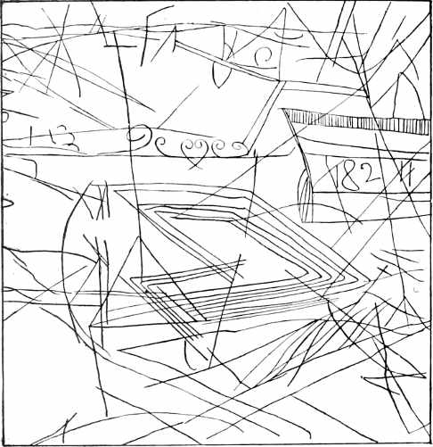
Fig. 1.—Palimpsest on Fairy rocks, Nova Scotia.
For examples of other copies printed from the rocks at Kejimkoojik lake, see Figs. 549, 550, 654, 655, 656, 657, 658, 717, 718, 739, 740, 741, 1254, 1255, and 1262. These offer intrinsic evidence of the Micmac origin of the early class of engravings.
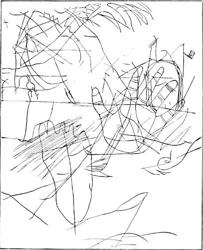
Fig. 2.—Palimpsest on Fairy rocks, Nova Scotia.
The presence of French names and styles of art in the drawings is explained by a story which was communicated by Louis Labrador, whose great-grandfather, old Ledore, according to his account, guided a body of French Acadians who, at the time of the expulsion, were not shipped off with the majority. They escaped the English in 1756 and traveled from the valley of Annapolis to Shelbourne, at the extreme southeast of the peninsula. During that passage they halted for a considerable time to recruit in the beautiful valley along the Kejimkoojik lake, on the very ground where these markings appear, which also was on the ancient Indian trail. Another local tradition, told by a resident of the neighborhood, gives a still earlier date for the French work. He says that after the capture of Port Royal, now Annapolis, in 1710, a party of the defeated Frenchmen, with a number of Indians as guides, went with their cattle to the wide meadows upon Kejimkoojik lake and remained there for a long time. It is exceedingly probable that the French would have been attracted to scratch on this fascinating smooth slate surface whether they had observed previous markings or not, but it seems evident that they did scratch over such previous markings. The latter, at least, antedated the beginning of the eighteenth century.
A general remark may be made regarding the Kejimkoojik drawings, that the aboriginal art displayed in them did not differ in any important degree from that shown in other drawings of the Micmacs and the Abnaki in the possession of the Bureau of Ethnology. Also that the rocks there reveal pictographic tendencies and practices which suggest explanations of similar work in other regions where less evidence remains of intent and significance. The attractive material of the slates and their convenient situation tempted past generations of Indians to record upon them the images of their current thoughts and daily actions. Hence the pictographic practice went into operation at this locality with unusual vigor and continuity. Although at Kejimkoojik lake there is an exceptional facility for determining the relative dates of the several horizons of scratchings, the suggestion there evoked may help to ascertain similar data elsewhere.
ONTARIO.
Mr. Charles Hallock kindly communicates information concerning pictographs on Nipigon bay, which is a large lake in the province of Ontario, 30 miles northwest of Lake Superior, with which it is connected by Nipigon river. He says:
The pictographs, which are principally of men and animals, occupy a zone some 60 feet long and 5 feet broad, about midway of the face of the rock; they are painted in blood-red characters, much darker than the color of the cliff itself.
He also, later, incloses a letter received by himself from Mr. Newton Flanagan, of the Hudson Bay Company, an extract from which is as follows:
About the dimensions of the red rock in Nipigon bay, upon which appear the Indian painted pictures, as near as I can give you at present, the face of the rock fronting the water is about 60 feet, rising to a greater height as it runs inland. The width along the water is something like 900 yards, depth quite a distance inland. The pictures are from 10 to 15 or perhaps 20 feet above the water; the pictures are representations of human figures, Indians in canoes, and of wild animals. They are supposed to have been painted ages ago, by what process or for what reason I am unable to tell you, nor do I know how the paint is made indelible.
As far as I can gather, the Indians here have no traditions in regard to those paintings, which I understand occur in several places throughout the country, and none of the Indians hereabouts nowadays practice any such painting.
MANITOBA.
Mr. Hallock also furnishes information regarding a petroglyph, the locality of which he gives as follows: Roche Percée, on the Souris river, in Manitoba, near the international boundary, 270 miles west of Dufferin, and nearly due north from Bismarck. This is an isolated rock in the middle of a plain, covered with pictographs of memorable events. It stands back from the river a half mile.
Mr. A. C. Lawson (a) gives an illustrated account of petroglyphs on the large peninsula extending into the Lake of the Woods and on an island adjacent to it. Strictly speaking this peninsula is in the district of Keewatin, but it is very near the boundary line of Manitoba, to which it is attached for administrative purposes. The account is condensed as follows:
On the north side of this peninsula, i. e., on the south shore of the northern half of the lake, about midway between the east and west shores, occurs one of the two sets of hieroglyphic markings. Lying off shore at a distance of a quarter to a half a mile, and making with it a long sheltered channel, is a chain of islands, trending east and west. On the south side of one of these islands, less than a mile to the west of the first locality, is to be seen the other set of inscriptions. The first set occurs on the top of a low, glaciated, projecting point of rock, which presents the characters of an ordinary roche moutonnée. The rock is a very soft, foliated, green, chloritic schist, into which the characters are more or less deeply carved. The top of the rounded point is only a few feet above the high-water mark of the lake, whose waters rise and fall in different seasons through a range of ten feet. The antiquity of the inscriptions is at once forced upon the observer upon a careful comparison of their weathering with that of the glacial grooves and striæ, which are very distinctly seen upon the same rock surface. Both the ice grooves and carved inscriptions are, so far as the eye can judge, identical in extent of weathering, though there was doubtless a considerable lapse of time between the disappearance of the glaciers and the date of the carving.
The island on which were found the other inscriptions is one of the many steep rocky islands known among the Indians as Ka-ka-ki-wa-bic min-nis, or Crow-rock island. The rock is a hard greenstone, not easily cut, and the inscriptions are not cut into the rock, but are painted with ochre, which is much faded in places. The surface upon which the characters are inscribed forms an overhanging wall protected from the rain, part of which has fallen down.
The Indians of the present day have no traditions about these inscriptions beyond the supposition that they must have been made by the “old people” long ago.
The sketches published as copies of these glyphs show spirals, concentric circles, crosses, horseshoe forms, arrow shapes, and other characters similar to those found on rocks in the southwestern part of the United States, and also to petroglyphs in Brazil, examples from both of which regions are presented in this work, under their appropriate headings.
BRITISH COLUMBIA.
Dr. Franz Boas (a) published an account of a petroglyph on Vancouver island (now presented as Fig. 3) which, slightly condensed, is translated as follows:
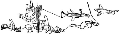
Fig. 3.—Petroglyph on Vancouver island.
The accompanying rock picture is found on the eastern shore of Sproat lake, near its southern outlet. Sproat lake lies about 10 kilometers north of the upper end of the Alberni fiord, which cuts deep into the interior of Vancouver island. In former times this region was the territory of the Hōpetschisāth, a tribe of the Nootka or Aht, who even now have a village some miles below the lake, at the entrance of Stamp river into the main river. That tribe, according to the statement of some of its older members, was a branch of the Kowitchin, who occupy the east side of Vancouver island, some kilometers northeast of the upper end of Alberni fiord. At that time the Ts’ēschāáth, another tribe of the Nootka, are said to have ascended the fiord and mixed with the Hōpetschisāth. The present inhabitants of the region know nothing concerning the origin of the rock picture. According to their legend, the rock on which it is carved was once the house of Kwótiath. Kwótiath is the wandering divinity in Nootka mythology, and corresponds approximately to the raven of the Tlinkit and Haida, the Qäls of the Kowitchin. The picture is found on a perpendicular rock wall about 7 meters high, which drops directly into the lake, so that it was necessary to make the copy while standing in the water. The rock is traversed in the middle by a broad cleft, narrowing below, from which blocks have fallen out which bore part of the drawing. To the north and south of the rock wall the shore rises gently, but rocky portions are found everywhere. The lines of the drawing are flat grooves, about two or three fingers’ breadth, and in many places are so weathered as to be hardly recognizable. They have been scraped into the rock probably by the points of sticks rubbing moist sand against it. No marks of blows of any kind are found. The figures are here given in the same relative position in which they are found on the rock, except that the upper one on the right hand is at a distance from all the others, at the southern end of the rock. The objects represented are evidently fishes or marine monsters. The middle figure to the left of the cleft may be a manned boat, the fore part of which is probably destroyed.
Dr. Boas says that the copy as found in the Verhandlungen is incorrect. The design on the right hand is reversed and is now corrected.
Mr. G. M. Sproat (a) mentions this petroglyph:
It is rudely done and apparently not of an old date. There are half a dozen figures intended to represent fishes or birds—no one can say which. The natives affirm that Quawteaht made them. In their general character these figures correspond to the rude paintings sometimes seen on wooden boards among the Ahts, or on the seal-skin buoys that are attached to the whale and halibut harpoons and lances. The meaning of these figures is not understood by the people; and I dare say if the truth were known, they are nothing but feeble attempts on the part of individual artists to imitate some visible objects which they had strongly in their minds.
SECTION 2. UNITED STATES.
Drawings or paintings on rocks are distributed generally over the greater part of the territory of the United States.
They are found on bowlders formed by the sea waves or polished by ice of glacial epochs; on the faces of rock ledges adjoining lakes and streams; on the high walls of canyons and cliffs; on the sides and roofs of caves; in short, wherever smooth surfaces of rock appear. Yet, while they are so frequent, there are localities to be distinguished in which they are especially abundant and noticeable. They differ markedly in character of execution and apparent subject-matter.
An obvious division can be made between the glyphs bearing characters carved or pecked and those painted without incision. There is also a third, though small, class in which the characters are both incised and painted. This division seems to coincide to a certain extent with geographic areas and is not fully explained by the influence of materials; it may, therefore, have some relation to the idiosyncrasy or development of the several authors, and consequently to tribal habitat and migrations.
In examining a chart of the United States in use by the Bureau of Ethnology, upon which the distribution of the several varieties of petroglyphs is marked, two facts are noticeable: First, the pecked and incised characters are more numerous in the northern and those expressed in colors more numerous in the southern areas. Second, there are two general groupings, distinguished by typical styles, one in the north Atlantic states and the other in the south Pacific states.
The north Atlantic group is in the priscan habitat of the tribes of the Algonquian linguistic family, and extends from Nova Scotia southward to Pennsylvania, where the sculpturings are frequent, especially on the Susquehanna, Monongahela, and Alleghany rivers, and across Ohio from Lake Erie to the Kanawha river, in West Virginia. Isolated localities bearing the same type are found westward on the Mississippi river and a few of its western tributaries, to and including the Wind river mountains, in Wyoming, the former habitat of the Blackfeet Indians. All of these petroglyphs present typical characters, sometimes undefined and complicated. From their presumed authors, they have been termed the Algonquian type. Upon close study and comparison they show many features in common which are absent in extra-limital areas.
Immediately south of the Kanawha river, in West Virginia, and extending southward into Virginia, Tennessee, and North Carolina, the pecked or sculptured petroglyphs are replaced by painted figures of a style differing from the Algonquian. These are in the area usually designated as Cherokee territory, but there is no evidence that they are the work of that tribe; indeed, there is no indication of their authorship. The absence of pecked characters in this area is certainly not due to an absence of convenient material upon which to record them as the country is as well adapted to the mode of incision as is the northern Atlantic area.
Upon the Pacific slope a few pecked as well as colored petroglyphs occur scattered irregularly throughout the extreme northern area west of the Sierra Nevada, but on the eastern side of that range of mountains petroglyphs appear in Idaho, which have analogues extending south to New Mexico and Arizona, with remarkable groups at intervals between these extremes. All of these show sufficient similarity of form to be considered as belonging to a type which is here designated “Shoshonean.” Tribes of that linguistic family still occupy, and for a long time have occupied, that territory. Most of this Shoshonean group consists of pecked or incised characters, though in the southern area unsculptured paintings predominate.
On the western side of the Sierra Nevada, from Visalia southward, at Tulare agency, and thence westward and southward along the Santa Barbara coast, are other groups of colored petroglyphs showing typical features resembling the Shoshonean. This resemblance may be merely accidental, but it is well known that there was intercourse between the tribes on the two sides of the Sierra Nevada, and the Shoshonean family is also represented on the Pacific slope south of the mountain range extending from San Bernardino west to Point Conception. In this manner the artistic delineation of the Santa Barbara tribes may have been influenced by contact with others.
Petroglyphs have seldom been found in the central area of the United States. In the wooded region of the Great lakes characters have been depicted upon birch bark for at least a century, while in the area between the Mississippi river and the Rocky mountains the skins of buffalo and deer have been used. Large rocks and cliffs favorably situated are not common in that country, which to a great extent is prairie.
In the general area of these typical groups characters are frequently found which appear intrusive, i. e., they have a strong resemblance not only to those found in other American groups, but are nearly identical with characters in other parts of the world. This fact, clearly established, prevents the adoption of any theory as to the authorship of many of the petroglyphs and thwarts attempts to ascertain their signification.
ALASKA.
Ensign Albert P. Niblack, U. S. Navy, (a) gives a brief account, with sketches, reproduced here as Fig. 4, of petroglyphs in Alaska, which were taken from rocks from the ancient village of Stikine, near Fort Wrangell. Others were found on rocks just above high-water mark around the sites of ruined and abandoned villages.
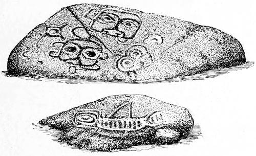
Fig. 4.—Petroglyphs in Alaska.
In the upper character the Alaskan typical style of human faces is noticeable. The lower gives a representation of the orca or whale killer, which the Haida believe to be a demon called Skana, about which there are many mythic tales. Mr. Niblack remarks:
In their paintings the favorite colors used are black, light green, and dark red. Whether produced in painting, tattooing, or relief carving, the designs are somewhat conventional. However rude the outline, there are for some animals certain conventional signs that clearly indicate to the initiated what figure is meant. With the brown bear it is the protruding tongue; with the beaver and wolf it is the character of the teeth; with the orca, the fin; with the raven, the sharp beak; with the eagle, the curved beak, etc.
ARIZONA.
Mr. G. K. Gilbert, of the U. S. Geological Survey, gives the following information concerning petroglyphs observed by him in the vicinity of San Francisco mountain, Arizona:
The localities of the sketches Figs. 5, 6, and 7 are about 35 miles east and southeast of San Francisco mountain, the material being a red sandstone, which stands in low buttes upon the plain. About these are mealing stones, fragments of pottery and chipped flints, giving evidence of the residence of sedentary Indians. So many localities of petroglyphs were seen that I regard it as probable that a large number could be found by search. The drawings in every case but one were produced by blows upon the surface of the rocks, breaking through the film of rock discolored by weathering so as to reveal (originally) the color of the interior of the rock. The single exception is the first pattern in Fig. 6, similar to the patterns on pottery and blankets, produced by painting with a white pigment on red rock. The original arrangement of the drawings upon the rock was not as a rule preserved, but they have approximately the original arrangement. I neglected to record the scale of the drawings, but the several pictures are drawn on approximately the same scale.
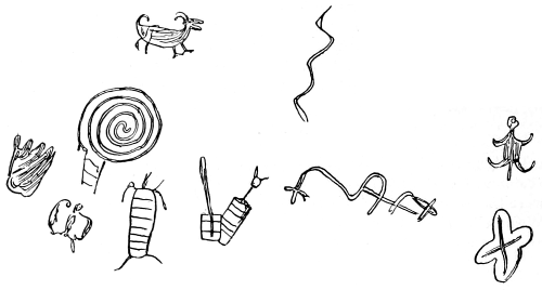
Fig. 5.—Petroglyph in Arizona.
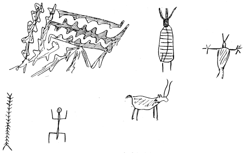
Fig. 6.—Petroglyph in Arizona.
All of these figures partake of the general type designated as the Shoshonean, and it is notable that close repetitions of some of the characters appear in petroglyphs in Tulare valley and Owens valley, California, which are described and illustrated in this section.
The object resembling a centipede, in Fig. 6, is a common form in various localities in Santa Barbara county, California, as will be observed by comparing the illustrations given in connection with that locality. In other of the Arizona and New Mexican petroglyphs similar outlines are sometimes engraved to signify the maize stalk.
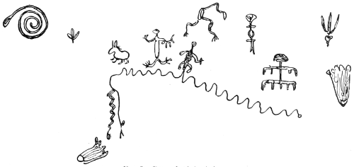
Fig. 7.—Petroglyph in Arizona.
Mr. Paul Holman, of the U. S. Geological Survey, reports that eight miles below Powers butte, on a mesa bordering on the Gila river and rising abruptly to the height of 150 feet, are pictographs covering the entire vertical face. Also on the summit of a spur of Oatman mountain, 200 yards from the Gila and 300 feet above it, are numbers of pictographs. Many of them are almost obliterated where they are on exposed surfaces.
Lieut. Col. Emory (a) reports that on a table-land near the Gila bend is a mound of granite bowlders, blackened by augite and covered with unknown characters, the work of human hands. On the ground near by were also traces of some of the figures, showing that some of the pictographs, at least, were the work of modern Indians. Others were of undoubted antiquity. He also reports in the same volume (b) that characters upon rocks of questionable antiquity occur on the Gila river at 32° 38′ 13″ N. lat. and 190° 7′ 30″ long. According to the plate, the figures are found upon bowlders and on the face of the cliff to the height of 30 feet.
Lieut. Whipple (a) remarks upon petroglyphs at Yampais spring, Williams river, as follows:
The spot is a secluded glen among the mountains. A high shelving rock forms a cave, within which is a pool of water and a crystal stream flowing from it. The lower surface of the rock is covered with pictographs. None of the devices seem to be of recent date.
Many of the country rocks lying on the Colorado plateau of northern Arizona, east of Peach springs, bear petroglyphs of considerable artistic workmanship. Some figures, observed by Dr. W. J. Hoffman in 1872, were rather elaborate and represented the sun, human beings in various styles approaching the grotesque, and other characters not understood. All of those observed were made by pecking the surface of basalt with a harder variety of stone.
Mr. Gilbert also obtained sketches of etchings in November, 1878, on Partridge creek, northern Arizona, at the point where the Beale wagon road comes to it from the east. He says: “The rock is cross-laminated Aubrey sandstone and the surfaces used are faces of the laminæ. All the work is done by blows with a sharp point. (Obsidian is abundant in the vicinity.) Some inscriptions are so fresh as to indicate that the locality is still resorted to. No Indians live in the immediate vicinity, but the region is a hunting ground of the Wallapais and Avasupais (Cosninos).”
Notwithstanding the occasional visits of the above named tribes, the characters submitted more nearly resemble those of other localities known to have been made by the Moki Pueblos.
Rock drawings are of frequent occurrence along the entire extent of the valley of the Rio Verde, from a short distance below Camp Verde to the Gila river.
Mr. Thomas V. Keam reports drawings on the rocks in Canyon Segy, and in Keam’s canyon, northeastern Arizona. Some forms occurring at the latter locality are found also upon Moki pottery.
Petroglyphs are reported by Lieut. Theodore Mosher, Twenty-second Infantry, U. S. Army, to have been discovered by Lieut. Casey’s party in December, 1887, on the Chiulee (or Chilalí) creek, 30 or 40 miles from its confluence with San Juan river, Arizona. A photograph made by the officer in charge of the party shows the characters to have been outlined by pecking, the designs resembling the Shoshonean type of pictographs, and those in Owens valley, California, a description of which is given below.
A figure, consisting of two concentric circles with a straight line running out from the larger circle, occurs, among other carvings, on one of the many sculptured bowlders seen by Mr. J. R. Bartlett (a) in the valley of the Gila river in Arizona. His representation of this bowlder is here copied as Fig. 8. His language is as follows:
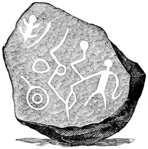
Fig. 8.—Petroglyph in Arizona.
I found hundreds of these bowlders covered with rude figures of men, animals, and other objects of grotesque forms, all pecked in with a sharp instrument. Many of them, however, were so much defaced by long exposure to the weather and by subsequent markings, that it was impossible to make them out. Among these rocks I found several which contained sculptures on the lower side, in such a position that it would be impossible to cut them where they then lay. Some weighed many tons each and would have required immense labor to place them there, and that, too, without an apparent object. The natural inference was that they had fallen down from the summit of the mountain after the sculptures were made on them. A few only seemed recent; the others bore the marks of great antiquity.
In the collections of the Bureau of Ethnology is an album or sketch book, which contains many drawings made by Mr. F. S. Dellenbaugh, from which the following sketches of petroglyphs in Arizona are selected, together with the brief references attached to each sheet.
Fig. 9 is a copy of characters appearing in Shinumo canyon, Arizona. They are painted, the middle and right hand figures being red, the human form having a white mark upon the abdomen; the left-hand figure of a man is painted yellow, the two plumes being red.
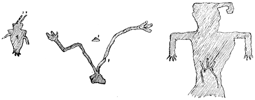
Fig. 9.—Petroglyph in Shinumo canyon, Arizona.
The petroglyphs in Fig. 10 are rather indistinct and were copied from the vertical wall of Mound canyon. The most conspicuous forms appear to be serpents.
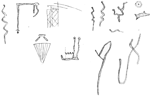
Fig. 10.—Petroglyph in Mound canyon, Arizona.
CALIFORNIA.
In the foothills of California, wherever overhanging and rain-protected rocks occur, they are covered with paintings of various kinds made by Indians. Those on Rocky hill, some 15 miles east of Visalia, are especially interesting. The sheltered rocks are here covered with images of men, animals, and various inanimate objects, as well as curious figures. The paint used is red, black, and white, and wherever protected it has stood the ravages of time remarkably well. In many places the paintings are as vivid as the day they were laid on. Deer, antelope, coyotes, birds, and turtles are figured quite frequently, and may indicate either names of chiefs or tribes, or animals slain in the hunt. Here are also circles, spirals, crowns or bars, etc., signs the meaning of which is yet doubtful.
Mr. H. W. Turner, in a letter dated June 3, 1891, furnishes sketches (Fig. 11) from this locality, and a description of them as follows:
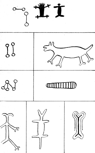
Fig. 11.—Petroglyphs near Visalia, California.
I send herewith a rough sheet of drawings of figures on the sheltered face of a huge granite cropping in Tulare county, California. One-half of the cropping had split off, leaving a nearly plane surface, on which the figures were drawn in red, white, and black pigments. The locality is known as Rocky point. They are now quarrying granite at the place. It lies about 12 miles nearly due east of Visalia, in the first foothills and south of Yokall creek. The figures appear to have been drawn many years ago, and numbers of them are now indistinct.
During the summer of 1882 Dr. Hoffman visited the Tule river agency, California, where he found a large rock painting, of which Fig. 983, infra, is a copy made by him. His description of it is as follows:
“The agency is upon the western side of the Sierra Nevada, in the headwater canyons of the branches of the south fork of Tule river. The country is at present occupied by several tribes of the Mariposan linguistic stock, and the only answer made to inquiries respecting the age or origin of the painting was that it was found there when the ancestors of the present tribes arrived. The local migrations of the various Indian tribes of this part of California are not yet known with sufficient certainty to determine to whom the records may be credited, but all appearances with respect to the weathering and disintegration of the rock upon which the record is engraved, the appearance of the coloring matter subsequently applied, and the condition of the small depressions made at the time for mixing the pigments with a viscous substance, indicate that the work was performed about a century ago.
“The Indians now at Tule river have occupied that part of the state for at least one hundred years, and the oldest now living state that the records were found by their ancestors, though whether more than two generations ago could not be ascertained.
“The drawings were outlined by pecking with a piece of quartz or other siliceous rock, the depth varying from a mere visible depression to a third of an inch. Having thus satisfactorily depicted the several ideas, colors were applied which appear to have penetrated the slight interstices between the crystalline particles of the rock, which had been bruised and slightly fractured by hammering with a piece of stone. It appears probable, too, that to insure better results the hammering was repeated after application of the colors.
“Upon a small bowlder, under the natural archway formed by the breaking of the large rock, small depressions were found which had been used as mortars for grinding and mixing the colors. These depressions average 2 inches in diameter and about 1 inch in depth. Traces of color still remain, mixed with a thin layer of a shining substance resembling a coating of varnish and of flinty hardness. This coating is so thin that it can not be removed with a steel instrument, and appears to have become a part of the rock itself.
“From the animals depicted upon the ceiling it seems that both beaver and deer were found in the country, and as the beaver tail and the hoofs of deer and antelope are boiled to procure glue, it is probable that the tribe which made these pictographs was as far advanced in respect to the making of glue and preparing of paints as most other tribes throughout the United States.
“Examination shows that the dull red color is red ocher, found in various places in the valley, while the yellow was an ocherous clay, also found there. The white color was probably obtained there, and is evidently earthy, though of what nature can only be surmised, not sufficient being obtainable from the rock picture to make satisfactory analysis with the blow-pipe. The composition of the black is not known, unless it was made by mixing clay and powdered charcoal. The latter is a preparation common at this day among other tribes.
“An immense granite bowlder, about 20 feet in thickness and 30 in length, is so broken that a lower quarter is removed, leaving a large square passageway through its entire diameter almost northwest and southeast. Upon the western wall of this passageway is a collection of the colored sketches of which Fig. 983 is a reduced copy. The entire face of the rock upon which the pictograph occurs measures about 12 or 15 feet in width and 8 in height. The largest human figure measures 6 feet in height, from the end of the toes to the top of the head, the others being in proportion as represented.
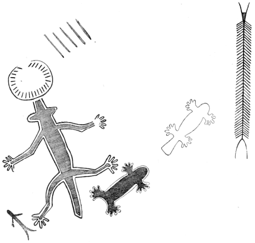
Fig. 12.—Petroglyph at Tule river, California.
“Upon the ceiling are a number of well executed drawings of the beaver, bear, centipede (Fig. 12), and bald eagle (Fig. 13). Many of the other forms indicated appear to represent some variety of insects, several of which are drawn with exaggerated antennæ, as in Fig. 14. It is curious to note the gradual blending of forms, as, for instance, that of the bear with those resembling the human figure, often found among the Shoshonean types in Arizona and New Mexico, some of which are described and figured infra.
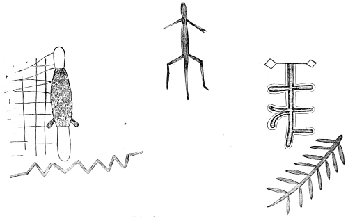
Fig. 13.—Petroglyph at Tule river, California.
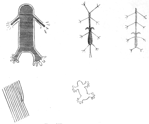
Fig. 14.—Petroglyph at Tule river, California.
“Fig. 15 embraces a number of characters on the ceiling. The left hand upper figure is in black, with a narrow line of red surrounding it. The drawing is executed neatly and measures about 18 inches in length. The remaining characters are in dull red, probably ocher, though the two on the left hand, beneath the one just mentioned, are more yellowish.
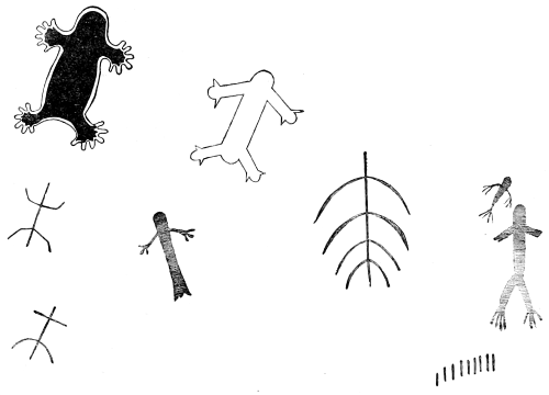
Fig. 15.—Petroglyph at Tule river, California.
“The first three forms in Fig. 16 are copies of human-like figures painted on the ceiling. They are each about 12 inches in length. The other form in Fig. 16 is white and is on the southern vertical wall of the passageway facing the north. It resembles some of the human forms occurring elsewhere in the same series of petroglyphs.”
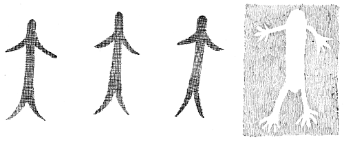
Fig. 16.—Petroglyph at Tule river, California.
OWENS VALLEY.
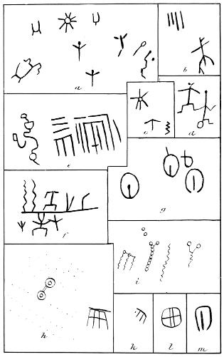
In the range of mountains forming the northwestern boundary of Owens valley are extensive groups of petroglyphs, apparently dissimilar to those found west of the Sierra Nevada. Dr. Hoffman, of the Bureau of Ethnology, hastily examined them in 1871 and more thoroughly in the autumn of 1884. They are now represented in Pls. I to XI. So large a space is given to these illustrations because of their intrinsic interest, and also because it is desirable to show for one locality what is true of some others, viz, the very large number of petroglyphs still to be found in groups and series. Even with the present illustrations, the petroglyphs in Owens valley are by no means exhaustively shown.
Dr. Hoffman’s report is as follows:
One of the most important series of groups is that in the northern portion of Owens valley, between the White mountains on the east and the Benton range on the west. On the western slope of the latter, at Watterson’s ranch, is a detached low butte or mesa, upon the blackened basaltic bowlders and cliffs of which are numerous deeply cut characters, the most interesting of which are reproduced in Pls. I and II. The illustrations are, approximately, one-twelfth real size. The designs of footprints, in the lower left-hand corner of Pl. I, vary in depth from half an inch to 1½ inches. They appear to have been pecked and finally worked down to a uniform and smooth surface by rubbing, as if with a piece of stone or with wood and sand.
In almost all, if not all, instances throughout the entire series referred to in this description the sculptured surfaces have assumed the same shining blackened luster as the original and undisturbed surface of the bowlder, caused by gradual oxidation of the iron present. This would seem to indicate considerable antiquity of the petroglyphs.
On the northeast angle of the mesa referred to were found the remains of an old camp, over which were scattered large quantities of arrowheads, knives, and flakes of obsidian. This in itself would be insignificant, but the fact that many of the specimens of this material have been lying exposed to the elements until the upper surface has undergone change in color, so as to become bleached and friable, in some instances to the depth of from one-tenth to one-fourth of an inch, warrants the inference that the relics may have been made by the same people who made the petroglyphs, as the worked relics generally differ from those of the present Indians by being larger and less elaborately finished.
At the lower end of the southeastern slope of the mesa are a number of flat rocks bearing mortar holes, which have no doubt been used in grinding grass seed and other grains.
In general type these petroglyphs correspond very closely to those of other areas, in which the so-called Shoshonian types occur, the most common, apart from those presented in Pls. I and II, consisting of concentric circles, rings, footprints of the bear and of man, and various outlines of the human form, beside numerous unintelligible forms.
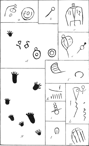
BUREAU OF ETHNOLOGY TENTH ANNUAL REPORT PL. I PETROGLYPHS IN OWENS VALLEY, CALIFORNIA.
BUREAU OF ETHNOLOGY TENTH ANNUAL REPORT PL. II PETROGLYPHS IN OWENS VALLEY, CALIFORNIA.
Southeastward of this locality there is a low divide leading across the Benton range into the broad, arid, sloping sand desert of Owens valley proper, but it is not until a point 12 miles south of Benton, along the line of the old stage road, is reached that petroglyphs of any consequence are met with. From this point southward, for a distance of 6 miles, large exposures and bowlders of basalt are scattered, upon which are great numbers of petroglyphs, pecked into the rock to depths of from half an inch to 1½ inches, and representing circles, footprints, human forms, etc.
The first series of illustrations, selected from numerous closely-connected bowlders, are here presented on Pls. III to VII. The designs marked a on Pl. III resemble serpents, while that at d is obviously such. This device is on the horizontal surface, and is pecked to the depth of about 1 inch. The scale of the drawing is one-thirtieth of the original petroglyph. The characters indicating the human form in e, g, and h resemble the ordinary Shoshonian type, and are like those from various localities in Arizona and southern Utah and Colorado.
BUREAU OF ETHNOLOGY TENTH ANNUAL REPORT PL. III PETROGLYPHS IN OWENS VALLEY, CALIFORNIA.
The upper characters in A on Pl. IV represent the trail of a grizzly bear—as indicated by the immense claws—followed by a human footprint. The original sculpturings are clearly cut, the toes of the man’s foot being cup-like, as if drilled with a blunt piece of wood and sand. The tracks average 15 inches in length and vary in depth from half an inch to more than an inch. The course of direction of the tracks, which are cut upon a horizontal surface, is from north-northeast to south-southwest.
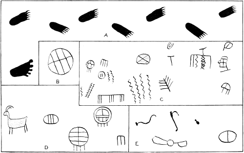
BUREAU OF ETHNOLOGY TENTH ANNUAL REPORT PL. IV PETROGLYPHS IN OWENS VALLEY, CALIFORNIA.
In E is the semblance of an apparently two-headed snake, as also in a on Pl. VII. It is possible that this was pecked into the rock to record the finding of such an anomaly. The occurrence of double-headed serpents is not unique, five or six instances having been recorded, one of which is from California, and a specimen may be seen in the collection of the U. S. National Museum.
In Pl. V, c, e, g are characters resembling some from the Canary islands [see Figs. 144 and 145], as well as many of the cupstones and dumb-bell forms from Scotland [see Figs. 149 and 150].
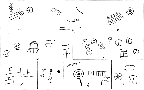
BUREAU OF ETHNOLOGY TENTH ANNUAL REPORT PL. V PETROGLYPHS IN OWENS VALLEY, CALIFORNIA.
An interesting specimen is presented in d, on Pl. VI, resembling the Ojibwa thunder bird, as well as etchings of Innuit workmanship to denote man [as shown in Fig. 1159]. The figures presented in Pl. III are the northernmost of the series, of which those on Pl. VII form the southernmost examples, the distance between these two points being about 2 miles.
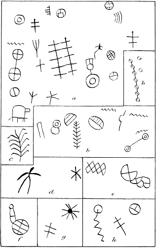
BUREAU OF ETHNOLOGY TENTH ANNUAL REPORT PL. VI PETROGLYPHS IN OWENS VALLEY, CALIFORNIA.
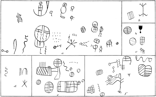
BUREAU OF ETHNOLOGY TENTH ANNUAL REPORT PL. VII PETROGLYPHS IN OWENS VALLEY, CALIFORNIA.
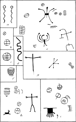
For the space of 4 miles southward there are a few scattered petroglyphs, to which reference will be made below, and the greatest number of characters are not found until the southernmost extremity of the entire series is reached. These are over the surface of immense bowlders lying on the east side of the road where it passes through a little valley known locally as the Chalk grade, probably on account of the whitened appearance of the sand and of some of the embankments. A general view of the faces of the bowlders upon which the chief sculpturings occur is presented in Fig. 17. The petroglyphs are represented in Pls. VIII to XI.
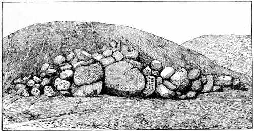
Fig. 17.—View of Chalk grade petroglyphs, Owens valley.
The figures presented in Pl. VIII are, with one exception, each about one-thirtieth the size of the original. The animal character in e is upon the top of the largest bowlder shown on Fig. 17, and is pecked to the depth of from one-fourth to one-half an inch. Portions of it are much defaced through erosion by sand blown by the strong summer winds. The characters in g are only one-tenth of the original size, but of depth similar to the preceding.
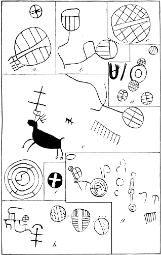
BUREAU OF ETHNOLOGY TENTH ANNUAL REPORT PL. VIII PETROGLYPHS IN OWENS VALLEY, CALIFORNIA.
On Pl. IX, a is one-twentieth the size of the original, while the remaining sculpturings are about one-tenth size. The cross in a is singularly interesting because of the elaborateness of its execution. The surface within the circle is pecked out so as to have the cross stand out bold and level with the original surface. This is true also of f on Pl. VIII. Pl. IX, b, contains some animal forms like those reported from New Mexico and Arizona, and Brazil [and presented in this work], especially that character to the right resembling a guanaco couchant, although, from its relationship to the figure of an antelope, in the same group, it no doubt is intended to represent one of the latter species.
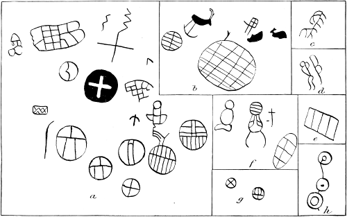
BUREAU OF ETHNOLOGY TENTH ANNUAL REPORT PL. IX PETROGLYPHS IN OWENS VALLEY, CALIFORNIA.
On Pl. X, as well as on others of this collection, are found many forms of circles with interior decoration, such as lines arranged by pairs, threes, etc., zigzag and cross lines, and other seemingly endless arrangements. They are interesting from the fact of the occurrence of almost identical forms in remote localities, as in the Canary islands and in Brazil. [These are figured and described infra.]
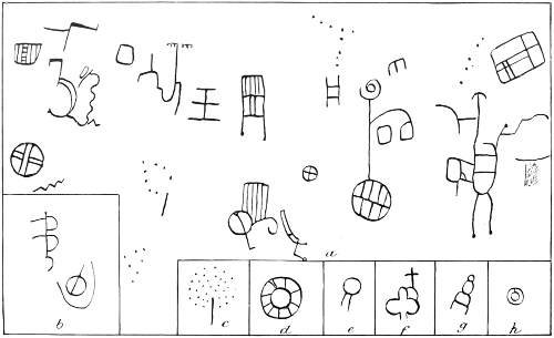
BUREAU OF ETHNOLOGY TENTH ANNUAL REPORT PL. X PETROGLYPHS IN OWENS VALLEY, CALIFORNIA.
It is probable that they are not meaningless, because the disposition of the Indian, as he is to-day, is such that no time would be spent upon such laborious work without an object, and only motives of a religious or ceremonial nature would induce him to expend the time and labor necessary to accomplish such results as are still presented. On Pl. XI, a, are more footprints and animal forms of the genus cervus or antelocapra. The figures in b and d, having an upright line with two crossing it at right angles, may signify either a lizard or man, the latter signification being probably the true one, as similar forms are drawn in petroglyphs of a Shoshonian type, as in Arizona. [See supra.]
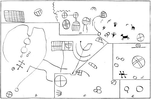
BUREAU OF ETHNOLOGY TENTH ANNUAL REPORT PL. XI PETROGLYPHS IN OWENS VALLEY, CALIFORNIA.
The country over which these records are scattered is arid beyond description and destitute of vegetation. Watterson’s ranch group is more favorably located, there being an abundance of springs and a stream running northward toward Black lake.
The only Indians found in this vicinity are Pai Utes, but they are unacquainted with the significance of the characters, and declare that they have no knowledge of the authors.
As to the age of the sculpturings nothing can be learned. The external surface of all the bowlders, as well as the surface of the deepest figures, is a glistening brownish black, due, possibly, to the presence of iron. The color of a freshly broken surface becomes lighter in tint as depth is attained, until at about one-half or three-fourths of an inch from the surface the rock is chocolate brown. How long it would take the freshly broken surface of this variety of rock to become thoroughly oxidized and blackened it is impossible even to conjecture, taking into consideration the physical conditions of the region and the almost entire absence of rainfall.
Upon following the most convenient course across the Benton range to reach Owen valley proper drawings are also found, though in limited numbers, and seem to partake of the character of indicators as to course of travel. By this trail the northernmost of the several groups of drawings above mentioned is the nearest and most easily reached.
The pictures upon the bowlders at Watterson’s are somewhat different from those found elsewhere. The number of specific designs is limited, many of them being reproduced from two to six or seven times, thus seeming to partake of the character of personal names.
In a communication dated Saratoga Springs, at the lower part of Death valley, California, February 5, 1891, Mr. E. W. Nelson says that about 200 yards from the springs, and on the side of a hill, he found several petroglyphs. He also furnished a sketch as an example of their general type, now presented as Fig. 18. The locality is in the lower end of Death valley. Mr. Nelson says:
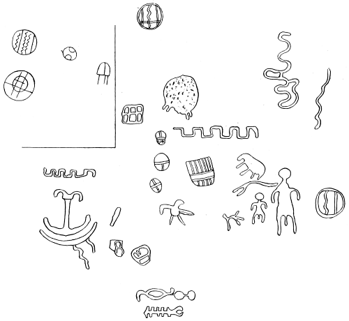
Fig. 18.—Petroglyphs in Death valley, California.
The spring here is in a basin some 60 to 80 acres in extent in which are ponds and tule marsh. Close by is an extensive ancient Indian camping ground, over which are scattered very many “chips” made from manufacturing arrow points from quartz crystal, chert, chalcedony, flint, and other similar material.
The figures in the sketch inclosed are situated relatively, as to size and location, as they occur on the rock. The latter is cracked and slopes at different angles, but the figures are all visible from a single point of view. There are several other figures in this group that are too indistinct to copy owing to age, or weather wearing. The group copied is the most extensive one seen, but many smaller groups and single figures are to be found on the rocks near by.
The Shoshoni inhabit this region and a few families of Shoshoni live about the Panamint mountains at present.
Dr. C. Hart Merriam, of the Department of Agriculture, on his return from the exploration of Death valley, kindly furnished a photograph of a ledge in Emigrant canyon, Panamint mountains, which was received too late for insertion in this work. This is much regretted, as a large number of petroglyphs are represented in groups. The characters are of the Shoshonean type. Among them are “Moki goats,” tridents, the Greek Φ, many crosses, and other figures shown in this chapter as found in the same general region.
In the Mojave desert, about 2 miles north of Daggett station, according to the Mining and Scientific Press (a) is a small porphyritic butte known as “Rattlesnake rock,” “so named by reason of the immense number of these reptiles that find shelter in this mass of rock.” The accompanying Fig. 19 is a reproduction of that given in the paper quoted. The author states that “the implement used in making these characters was evidently a dull-pointed stone, as the lines are not sharp, and the sides of the indentation show marks of striation.”
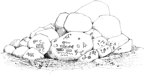
Fig. 19.—Rattlesnake rock, Mojave desert, California.
Lieut. Whipple reports the discovery of pictographs at Piute creek, about 30 miles west of the Mojave villages. These are carved upon a rock, “are numerous, appear old, and are too confusedly obscured to be easily traceable.” They bear great general resemblance to drawings scattered over northeast Arizona, southern Utah, and western New Mexico.
From information received from Mr. Alphonse Pinart, pictographic records exist in the hills east of San Bernardino, somewhat resembling those at Tule river in the southern spurs of the Sierra Nevada, Kern county.
Mr. Willard J. Whitney, of Elmhurst, Lackawanna county, Pennsylvania, gives information regarding nearly obliterated pecked petroglyphs upon two flat granite rocks, or bowlders, on the summit of a mountain 4 miles directly west of Escondido, San Diego county, California. The designs are not colored, and are not more than one-eighth or one-fourth of an inch in depth. There is a good lookout from the eminence, but there are no indications of either trails or burials in the vicinity.
This may be the locality mentioned by Mr. Barnes, of San Diego, who furnished information relating to petroglyphs in San Diego county.
Dr. Hoffman reports the following additional localities in Santa Barbara and Los Angeles counties. Fifteen miles west of Santa Barbara, on the northern summit of the Santa Ynez range, and near the San Marcos pass, is a group of paintings in red and black. Fig. 20 resembles a portion of a checker-board in the arrangement of squares.
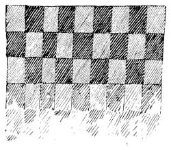
Fig. 20.—Petroglyph near San Marcos pass, California.
Serpentine and zigzag lines occur, as also curved lines with serrations on the concave sides; figures of the sun; short lines and groups of short parallel lines, and figures representing types of insect forms also appear, as shown in Figs. 21 and 22.
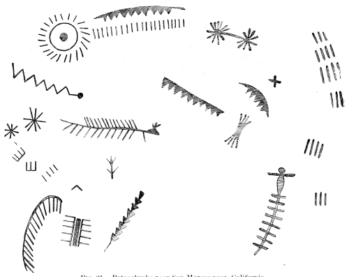
Fig. 21.—Petroglyphs near San Marcos pass, California.
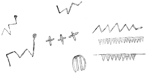
Fig. 22.—Petroglyphs near San Marcos pass, California.
These paintings are in a cavity near the base of an immense bowlder, over 20 feet in height. A short distance from this is a flat granitic bowlder, containing twenty-one mortar holes, which had evidently been used by visiting Indians during the acorn season. Oaks are very abundant, and their fruit formed one of the sources of subsistence.
Three miles west-northwest of this locality, in the valley near the base of the mountain, are indistinct figures in faded red, painted upon a large rock. The characters appear similar, in general, to those above mentioned.
Forty-three miles west of Santa Barbara, in the Najowe valley, is a promontory, at the base of which is a large shallow cavern, the opening being smaller than the interior, upon the roof and back of which are many designs, some of which are reproduced in Fig. 23, of forms similar to those observed at San Marcos pass. Several characters appear to have been drawn at a later date than others, such as horned cattle, etc. The black used was a manganese compound, while the red pigments consist of ferruginous clays, abundant at numerous localities in the mountain canyons.
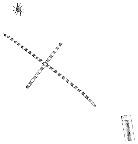
Fig. 23.—Petroglyphs in Najowe valley, California.
Some of the human figures are drawn with the hands and arms in the attitude of making the gestures for surprise or astonishment, and negation, as in Fig. 24.
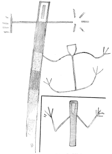
Fig. 24.—Petroglyphs in Najowe valley, California.
The characters in Fig. 25 resemble forms which occur at Tulare valley, and in Owens valley, respectively, and insect forms also occur as in Fig. 26.
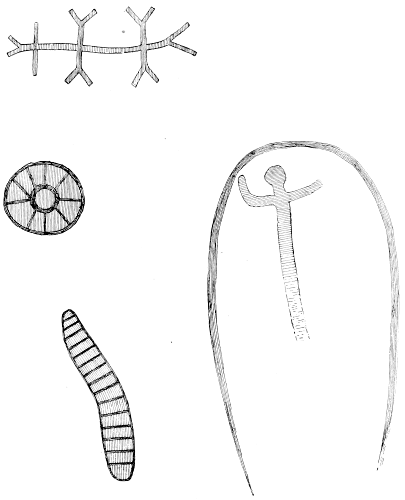
Fig. 25.—Petroglyphs, Najowe valley, California.
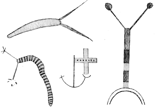
Fig. 26.—Petroglyphs in Najowe valley, California.
Other designs abounding at this locality are shown in Figs. 27 and 28.
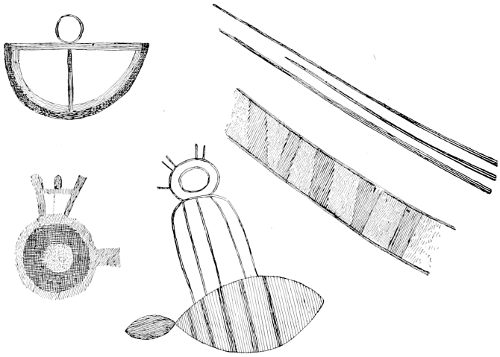
Fig. 27.—Petroglyphs in Najowe valley, California.
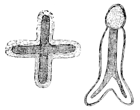
Fig. 28.—Petroglyphs in Najowe valley, California.
One of the most extensive groupings, and probably the most elaborately drawn, is in the Carisa plain, near Mr. Oreña’s ranch, 60 or 70 miles due north of Santa Barbara. The most conspicuous figure is that of the sun, resembling a human face, with ornamental appendages at the cardinal points, and bearing striking resemblance to some Moki masks and pictographic work. Serpentine lines and anomalous forms also abound.
Four miles northeast of Santa Barbara, near the residence of Mr. Stevens, is an isolated sandstone bowlder measuring about 20 feet high and 30 feet in diameter, upon the western side of which is a slight cavity bearing designs shown in Fig. 29, which correspond in general form to others in Santa Barbara county. The gesture for negation appears in the attitude of the human figures.
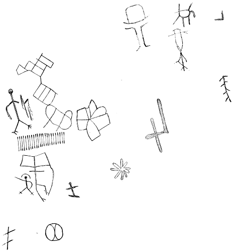
Fig. 29.—Petroglyphs near Santa Barbara, California.
Half a mile farther east, on Dr. Coe’s farm, is another smaller bowlder, in a cavity of which various engravings appear shown in Fig. 30. Parts of the drawings have disappeared through disintegration of the rock, which is called “Pulpit rock,” on account of the shape of the cavity, its position at the side of the narrow valley, and the echo observed upon speaking a little above the ordinary tone of voice.
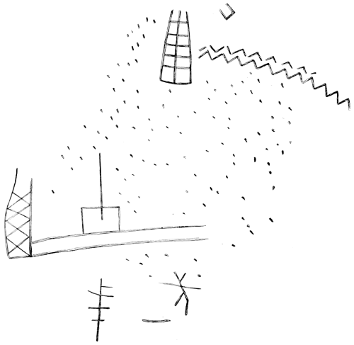
Fig. 30.—Petroglyphs near Santa Barbara, California.
Painted rocks also occur in the Azuza canyon, about 30 miles northeast of Los Angeles, of which Fig. 31 gives copies.
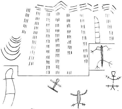
Fig. 31.—Petroglyphs in Azuza canyon, California.
Just before his departure from the Santa Barbara region, Dr. Hoffman was informed of the existence of eight or nine painted records in that neighborhood, which up to that time had been observed only by a few sheep-herders and hunters.
Mr. L. L. Frost, of Susanville, California, reports the occurrence of pictographs (undoubtedly petroglyphs) 15 miles south of that town, on Willow creek, and at Milford, in the lower end of the valley. No details were furnished as to their general type and condition.
On Porter creek, 9 miles southwest of Healdsburg, on a large bowlder of hornblende syenite, petroglyphs similar to those found in Arizona and Nevada are to be seen. They are generally oblong circles or ovals, some of which contain crosses.
Figs. 32 and 33 are reduced copies 1/32 of original size of colored petroglyphs found by Dr. Hoffman in September, 1884, 12 miles west-northwest of the city of Santa Barbara, California. The locality is almost at the summit of the Santa Ynez range of mountains; the gray sandstone rock on which they are painted is about 30 feet high and projects from a ridge so as to form a very marked promontory extending into a narrow mountain canyon. At the base of the western side of this bowlder is a rounded cavity, measuring on the inside about 15 feet in width and 8 feet in height. The floor ascends rapidly toward the back of the cave, and the entrance is rather smaller in dimensions than the above measurements of the interior. About 40 yards west of this rock is a fine spring of water. One of the four old Indian trails leading northward across the mountains passes by this locality, and it is probable that this was one of the camping places of the tribe which came south to trade, and that some of its members were the authors of the paintings. The three trails beside the one just mentioned cross the mountains at several points east of this, the most distant being about 15 miles. Other trails were known, but these four were most direct to the immediate vicinity of the Spanish settlement which sprang up shortly after the establishment of the Santa Barbara mission in 1786. The appearance and position of these and other pictographs in the vicinity appear to be connected with the several trails. The colors used in the paintings are red and black.
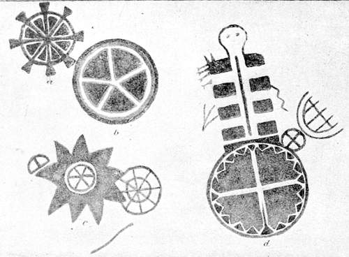
Fig. 32.—Petroglyph in Santa Barbara county, California.
The circles figured in b and d of Fig. 32, and c, r, and w of Fig. 33, together with other similar circular marks bearing cross lines upon the interior, were at first unintelligible, as their forms among various tribes have very different signification. The character in Fig. 32, above and projecting from d, resembles the human form, with curious lateral bands of black and white, alternately. Two similar characters appear, also, in Fig. 33, a, b. In a the lines from the head would seem to indicate a superior rank or condition of the person depicted.
At the private ethnologic collection of Mr. A. F. Coronel, of Los Angeles, California, Dr. Hoffman discovered a clue to the general import of the above petroglyphs, as well as the signification of some of their characters. In a collection of colored illustrations of old Mexican costumes he found blankets bearing borders and colors nearly identical with those shown in the circles in Fig. 32, d, and Fig. 33, c, r, w. It is probable that the circles represent bales of blankets which early became articles of trade at the Santa Barbara mission. If this supposition is correct, the cross lines would seem to represent the cords used in tying the blankets into bales, which same cross lines appear as cords in l, Fig. 33. Mr. Coronel also possesses small figures of Mexicans, of various conditions of life, costumes, trades, and professions, one of which, a painted statuette, is a representation of a Mexican lying down flat upon an outspread serape, similar in color and form to the black and white bands shown in the upper figure of d, Fig. 32, and a, b, of Fig. 33, and instantly suggesting the explanation of those figures. Upon the latter the continuity of the black and white bands is broken, as the human figures are probably intended to be in front, or on top, of the drawings of the blankets.
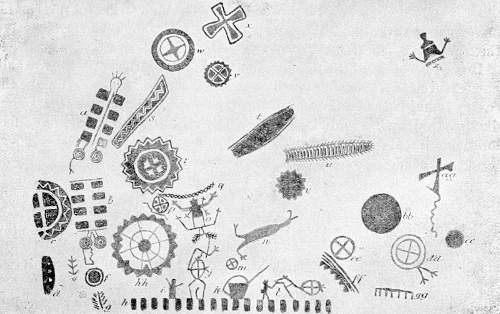
Fig. 33.—Petroglyph in Santa Barbara county, California.
The small statuette above mentioned is that of a Mexican trader, and if the circles in the petroglyphs are considered to represent bales of blankets, the character in Fig. 32, d, is still more interesting, from the union of one of these circles with a character representing the trader, i. e., the man possessing the bales. Bales, or what appear to be bales, are represented to the top and right of the circle in d, in that figure. In Fig. 33, l, a bale is upon the back of what appears to be a horse, led in an upward direction by an Indian whose headdress and ends of the breechcloth are visible. To the right of the bale are three short lines, evidently showing the knot or ends of the cords used in tying a bale of blankets without colors, therefore of less importance, or of other goods. Other human forms appear in the attitude of making gestures, one also in j, Fig. 33, probably carrying a bale of goods. In the same figure u represents a centipede, an insect found occasionally south of the mountains, but reported as extremely rare in the immediate northern regions. For remarks upon x in the same figure see Chapter XX, Section 2, under the heading The Cross.
Mr. Coronel stated that when he first settled in Los Angeles, in 1843, the Indians living north of the San Fernando mountains manufactured blankets of the fur and hair of animals, showing transverse bands of black and white similar to those depicted, which were sold to the inhabitants of the valley of Los Angeles and to Indians who transported them to other tribes.
It is probable that the pictographs are intended to represent the salient features of a trading expedition from the north. The ceiling of the cavity found between the paintings represented in the two figures has disappeared, owing to disintegration, thus leaving a blank about 4 feet long, and 6 feet from the top to the bottom between the paintings as now presented.
COLORADO.
Petroglyphs are reported by Mr. Cyrus F. Newcomb as found upon cliffs on Rock creek, 15 miles from Rio Del Norte, Colorado. Three small photographs, submitted with this statement, indicate the characters to have been pecked; they consist of men on horseback, cross-shaped human figures, animals, and other designs greatly resembling those found in the country of the Shoshonean tribes, examples of which are given infra.
Another notice of the same general locality is made by Capt. E. L. Berthoud (a) as follows:
The place is 20 miles southeast of Rio Del Norte, at the entrance of the canyon of the Piedra Pintada (Painted rock) creek. The carvings are found on the right of the canyon or valley and upon volcanic rocks. They bear the marks of age and are cut in, not painted, as is still done by the Utes everywhere. They are found for a quarter of a mile along the north wall of the canyon, on the ranches of W. M. Maguire and F. T. Hudson, and consist of all manner of pictures, symbols, and hieroglyphics done by artists whose memory even tradition does not now preserve. The fact that these are carvings done upon such hard rock invests them with additional interest, as they are quite distinct from the carvings I saw in New Mexico and Arizona on soft sandstone. Though some of them are evidently of much greater antiquity than others, yet all are ancient, the Utes admitting them to have been old when their fathers conquered the country.
Mr. Charles D. Wright, of Durango, Colorado, in a communication dated February 20, 1885, gives an account of some “hieroglyphs” on rocks and upon the walls of cliff houses near the boundary line between Colorado and New Mexico. He says:
The following were painted in red and black paints on the wall (apparently the natural rock wall) of a cliff house: At the head was a chief on his horse, armed with spear and lance and wearing a pointed hat and robe; behind this character were some twenty characters representing people on horses lassoing horses, etc. In fact the whole scene represented breaking camp and leaving in a hurry. The whole painting measured about 12 by 16 feet.
Mr. Wright further reports characters on rocks near the San Juan river. Four characters represent men as if in the act of taking an obligation, hands extended, and wearing a “kind of monogram on breast, and at their right are some hieroglyphics written in black paint covering a space 3 by 4 feet.”
The best discussed and probably the most interesting of the petroglyphs in the region are described and illustrated by Mr. W. H. Holmes (a), of the Bureau of Ethnology. The illustrations are here reproduced in Figs. 34 to 37, and the remarks of Mr. Holmes, slightly condensed, are as follows:
The forms reproduced in Fig. 34 occur on the Rio Mancos, near the group of cliff houses. They are chipped into the rock evidently by some very hard implement and rudely represent the human figure. They are certainly not attempts to represent nature, but have the appearance rather of arbitrary forms, designed to symbolize some imaginary being.
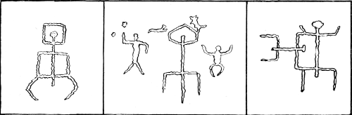
Fig. 34.—Petroglyphs on the Rio Mancos, Colorado.
The forms shown in Fig. 35 were found in the same locality, not engraved, but painted in red and white clay upon the smooth rocks. These were certainly done by the cliff-builders, and probably while the houses were in process of construction, since the material used is identical with the plaster of the houses. The sketches and notes were made by Mr. Brandegee. The reproduction is approximately one-twelfth the size of the original.
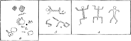
Fig. 35.—Petroglyphs on the Rio Mancos, Colorado.
The examples shown in Fig. 36 occur on the Rio San Juan about 10 miles below the mouth of the Rio La Plata and are actually in New Mexico. A low line of bluffs, composed of light-colored massive sandstones that break down in great smooth-faced blocks, rises from the river level and sweeps around toward the north. Each of these great blocks has offered a very tempting tablet to the graver of the primitive artist, and many of them contain curious and interesting inscriptions. Drawings were made of such of these as the limited time at my disposal would permit. They are all engraved or cut into the face of the rock, and the whole body of each figure has generally been chipped out, frequently to the depth of one-fourth or one-half of an inch.
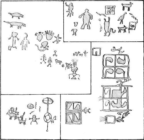
Fig. 36.—Petroglyphs on the Rio San Juan, New Mexico.
The work on some of the larger groups has been one of immense labor, and must owe its completion to strong and enduring motives. With a very few exceptions the engraving bears undoubted evidence of age. Such new figures as occur are quite easily distinguished both by the freshness of the chipped surfaces and by the designs themselves. The curious designs given in the final group have a very perceptible resemblance to many of the figures used in the embellishment of pottery.
The most striking group observed is given in Fig. 37 A, same locality. It consists of a great procession of men, birds, beasts, and fanciful figures. The whole picture as placed upon a rock is highly spirited and the idea of a general movement toward the right, skillfully portrayed. A pair of winged figures hover about the train as if to watch, or direct its movements; behind these are a number of odd figures, followed by an antlered animal resembling a deer, which seems to be drawing a notched sledge containing two figures of men. The figures forming the main body of the procession appear to be tied together in a continuous line, and in form resemble one living creature about as little as another. Many of the smaller figures above and below are certainly intended to represent dogs, while a number of men are stationed about here and there as if to keep the procession in order.
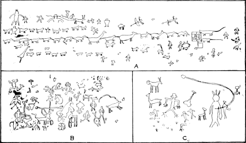
Fig. 37.—Petroglyphs on the Rio San Juan, New Mexico.
As to the importance of the event recorded in this picture, no conclusions can be drawn; it may represent the migration of a tribe or family or the trophies of a victory. A number of figures are wanting in the drawing at the left, while some of those at the right may not belong properly to the main group. The reduction is, approximately, to one-twelfth.
Designs B and C of the same figure represent only the more distinct portions of two other groups. The complication of figures is so great that a number of hours would have been necessary for their delineation, and an attempt to analyze them here would be fruitless.
It will be noticed that the last two petroglyphs are in New Mexico, but they are so near the border of Colorado and so connected with the series in that state that they are presented under the same heading.
CONNECTICUT.
The following account is extracted from Rafn’s Antiquitates Americanæ (a):
In the year 1789 Doctor Ezra Stiles, D. D., visited a rock situated in the Township of Kent in the State of Connecticut, at a place called Scaticook, by the Indians. He thus describes it: “Over against Scaticook and about one hundred rods East of Housatonic River, is an eminence or elevation which is called Cobble Hill. On the top of this stands the rock charged with antique unknown characters. This rock is by itself and not a portion of the Mountains; it is of White Flint; ranges North and South; is from twelve to fourteen feet long; and from eight to ten wide at base and top; and of an uneven surface. On the top I did not perceive any characters; but the sides all around are irregularly charged with unknown characters, made not indeed with the incision of a chisel, yet most certainly with an iron tool, and that by pecks or picking, after the manner of the Dighton Rock. The Lacunae or excavations are from a quarter to an inch wide; and from one tenth to two tenths of an inch deep. The engraving did not appear to be recent or new, but very old.”
GEORGIA.
Charles C. Jones, jr., (a) describes a petroglyph in Georgia as follows:
In Forsyth county, Georgia, is a carved or incised bowlder of fine grained granite, about 9 feet long, 4 feet 6 inches high, and 3 feet broad at its widest point. The figures are cut in the bowlder from one-half to three-fourths of an inch deep. It is generally believed that they are the work of the Cherokees.
The illustration given by him is here reproduced in Fig. 38. It will be noted that the characters in it are chiefly circles, including plain, nucleated, and concentric, sometimes two or more being joined by straight lines, forming what is now known as the “spectacle shaped” figure. The illustrations should be compared with the many others presented in this paper under the heading of Cup Sculptures, see Chapter V, infra.
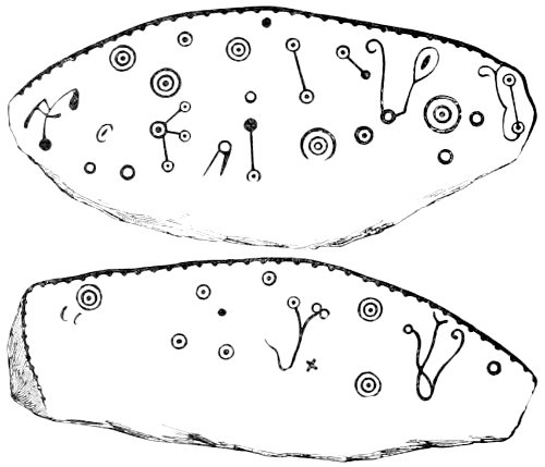
Fig. 38.—Petroglyphs in Georgia.
Dr. M. F. Stephenson (a) mentions sculptures of human feet, various animals, bear tracks, etc., in Enchanted mountain, Union county, Georgia. The whole number of sculptures is reported as one hundred and forty-six.
Mr. Jones (b) gives a different résumé of the objects depicted, as follows:
Upon the Enchanted mountain, in Union county, cut in plutonic rock, are the tracks of men, women, children, deer, bears, bisons, turkeys, and terrapins, and the outlines of a snake, of two deer, and of a human hand. These sculptures—so far as they have been ascertained and counted—number one hundred and thirty-six. The most extravagant among them is that known as the footprint of the “Great Warrior.” It measures 18 inches in length and has six toes. The other human tracks and those of the animals are delineated with commendable fidelity.
IDAHO.
Mr. G. K. Gilbert, of the U. S. Geological Survey, has furnished a small collection of drawings of Shoshonean petroglyphs from Oneida, Idaho, shown in Fig. 39. Some of them appear to be totemic characters, and possibly were made to record the names of visitors to the locality.
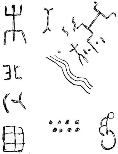
Fig. 39.—Petroglyphs in Idaho (Shoshonean).
Mr. Willard D. Johnson, of the U. S. Geological Survey, reports pictographic remains observed by him near Oneida, Idaho, in 1879. The figures represent human beings and were on a rock of basalt.
A copy of another petroglyph found in Idaho appears in Fig. 1092, infra.
ILLINOIS.
Petroglyphs are reported by Mr. John Criley as occurring near Ava, Jackson county, Illinois. The outlines of the characters observed by him were drawn from memory and submitted to Mr. Charles S. Mason, of Toledo, Ohio, through whom they were furnished to the Bureau of Ethnology. Little reliance can be placed upon the accuracy of such drawing, but from the general appearance of the sketches the originals of which they are copies were probably made by one of the middle Algonquian tribes of Indians.
The “Piasa” rock, as it is generally designated, was referred to by the missionary explorer Marquette in 1675. Its situation was immediately above the city of Alton, Illinois.
Marquette’s remarks are translated by Dr. Francis Parkman (a) as follows:
On the flat face of a high rock were painted, in red, black, and green, a pair of monsters, each “as large as a calf, with horns like a deer, red eyes, a beard like a tiger, and a frightful expression of countenance. The face is something like that of a man, the body covered with scales; and the tail so long that it passes entirely round the body, over the head, and between the legs, ending like that of a fish.”
Another version, by Davidson and Struvé (a), of the discovery of the petroglyph is as follows:
Again they (Joliet and Marquette) were floating on the broad bosom of the unknown stream. Passing the mouth of the Illinois, they soon fell into the shadow of a tall promontory, and with great astonishment beheld the representation of two monsters painted on its lofty limestone front. According to Marquette, each of these frightful figures had the face of a man, the horns of a deer, the beard of a tiger, and the tail of a fish so long that it passed around the body, over the head, and between the legs. It was an object of Indian worship and greatly impressed the mind of the pious missionary with the necessity of substituting for this monstrous idolatry the worship of the true God.
A footnote connected with the foregoing quotation gives the following description of the same rock:
Near the mouth of the Piasa creek, on the bluff, there is a smooth rock in a cavernous cleft, under an overhanging cliff, on whose face, 50 feet from the base, are painted some ancient pictures or hieroglyphics, of great interest to the curious. They are placed in a horizontal line from east to west, representing men, plants, and animals. The paintings, though protected from dampness and storms, are in great part destroyed, marred by portions of the rock becoming detached and falling down.
Mr. McAdams (a), of Alton, Illinois, says “The name Piasa is Indian and signifies, in the Illini, ‘The bird which devours men.’” He furnishes a spirited pen-and-ink sketch, 12 by 15 inches in size and purporting to represent the ancient painting described by Marquette. On the picture is inscribed the following in ink: “Made by Wm. Dennis, April 3d, 1825.” The date is in both letters and figures. On the top of the picture in large letters are the two words, “FLYING DRAGON.” This picture, which has been kept in the old Gilham family of Madison county and bears the evidence of its age, is reproduced as Fig. 40.
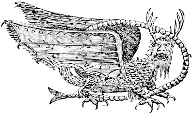
Fig. 40.—The Piasa petroglyph.
He also publishes another representation (Fig. 41) with the following remarks:
One of the most satisfactory pictures of the Piasa we have ever seen is in an old German publication entitled “The Valley of the Mississippi Illustrated. Eighty illustrations from nature, by H. Lewis, from the Falls of St. Anthony to the Gulf of Mexico,” published about the year 1839 by Arenz & Co., Düsseldorf, Germany. One of the large full-page plates in this work gives a fine view of the bluff at Alton, with the figure of the Piasa on the face of the rock. It is represented to have been taken on the spot by artists from Germany. We reproduce that part of the bluff (the whole picture being too large for this work) which shows the pictographs. In the German picture there is shown just behind the rather dim outlines of the second face a ragged crevice, as though of a fracture. Part of the bluff’s face might have fallen and thus nearly destroyed one of the monsters, for in later years writers speak of but one figure. The whole face of the bluff was quarried away in 1846-’47.
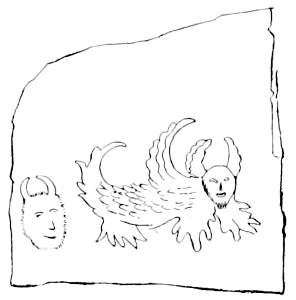
Fig. 41.—The Piasa petroglyph.
Under Myths and Mythic Animals, Chapter XIV, Section 2, are illustrations and descriptions which should be compared with these accounts, and Chapter XXII gives other examples of errors and discrepancies in the description and copying of petroglyphs.
Mr. A. D. Jones (a) says of the same petroglyph:
After the distribution of firearms among the Indians, bullets were substituted for arrows, and even to this day no savage presumes to pass the spot without discharging his rifle and raising his shout of triumph. I visited the spot in June (1838) and examined the image and the ten thousand bullet marks on the cliff seemed to corroborate the tradition related to me in the neighborhood.
Mr. McAdams, loc. cit., also reports regarding Fig. 42:
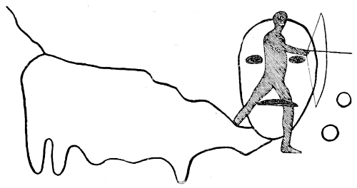
Fig. 42.—Petroglyph on the Illinois river.
Some twenty-five or thirty miles above the mouth of the Illinois river, on the west bank of that stream, high up on the smooth face of an overhanging cliff, is another interesting pictograph sculptured deeply in the hard rock. It remains to-day probably in nearly the same condition it was when the French voyagers first descended the river and got their first view of the Mississippi. The animal-like body, with the human head, is carved in the rock in outline. The huge eyes are depressions like saucers, an inch or more in depth, and the outline of the body has been scooped out in the same way; also the mouth.
The figure of the archer with the drawn bow, however, is painted, or rather stained with a reddish brown pigment, over the sculptured outline of the monster’s face.
Mr. McAdams suggests that the painted figure of the human form with the bow and arrows was made later than the sculpture.
The same author (b) says, describing Fig. 43:

Fig. 43.—Petroglyph near Alton, Illinois.
Some 3 or 4 miles above Alton, high up beneath the overhanging cliff, which forms a sort of cave shelter on the smooth face of a thick ledge of rock, is a series of paintings, twelve in number. They are painted or rather stained in the rock with a reddish brown pigment that seems to defy the tooth of time. It may be said, however, that their position is so sheltered that they remain almost perfectly dry. We made sketches of them some thirty years ago and on a recent visit could see that they had changed but little, although their appearance denotes great age.
These pictographs are situated on the cliff more than a hundred feet above the river. A protruding ledge, which is easily reached from a hollow in the bluff, leads to the cavernous place in the rock.
Mr. James D. Middleton, formerly of the Bureau of Ethnology, mentions the occurrence of petroglyphs on the bluffs of the Mississippi river, in Jackson county, about 12 miles below Rockwood. Also of others about 4 or 5 miles from Prairie du Rocher, near the Mississippi river.
IOWA.
Mr. P. W. Norris, of the Bureau of Ethnology, found numerous caves on the banks of the Mississippi river, in northeastern Iowa, 4 miles south of New Albion, containing incised petroglyphs. Fifteen miles south of this locality paintings occur on the cliffs. He also discovered painted characters upon the cliffs on the Mississippi river, 19 miles below New Albion.
KANSAS.
Mr. Edward Miller reports in Proceedings of the American Philosophical Society, vol. X, 1869, p. 383, the discovery of a petroglyph near the line of the Union Pacific railroad, 15 miles southeast of Fort Harker, formerly known as Fort Ellsworth, Kansas. The petroglyph is upon a formation belonging to No. 1, Lower Cretaceous group, according to the classification of Meek and Hayden.
The parts of the two plates VII and VIII of the work cited, which bear the inscriptions, are now presented as Fig. 44, being from two views of the same rock.
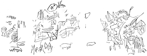
Fig. 44.—Petroglyphs in Kansas.
KENTUCKY.
Mr. James D. Middleton, formerly of the Bureau of Ethnology, in a letter dated August 14, 1886, reports that at a point in Union county, Kentucky, nearly opposite Shawneetown, Illinois, petroglyphs are found, and from the description given by him they appear to resemble those in Jackson county, Illinois, mentioned above.
Mr. W. E. Barton, of Wellington, Ohio, in a communication dated October 4, 1890, writes as follows:
At Clover Bottom, Kentucky, on a spur of the Big Hill, in Jackson county, about 13 miles from Berea, is a large rock which old settlers say was covered with soil and vegetation within their memory. Upon it are representations of human tracks, with what appear to be those of a bear, a horse, and a dog. These are all in the same direction, as though a man leading a horse, followed the dog upon the bear’s track. Crossing these is a series of tracks of another and larger sort which I can not attempt to identify. The stone is a sandstone in the subcarboniferous. As I remember, the strata are nearly horizontal, but erosion has made the surface a slope of about 20°. The tracks ascending the slope cross the strata. I have not seen them for some years.
The crossing of the strata shows that the tracks are the work of human hands, if indeed it were not preposterous to think of anything else in rocks of that period. Still the tracks are so well made that one is tempted to ask if they can be real. They alternate right and left, though the erosion and travel have worn out some of the left tracks. A wagon road passes over the rock and was the cause of the present exposure of the stone. It can be readily found a fourth of a mile or less from the Pine Grove schoolhouse.
MAINE.
A number of inscribed rocks have been found in Maine and information of others has been obtained. The most interesting of them and the largest group series yet discovered in New England is shown in Pl. XII.
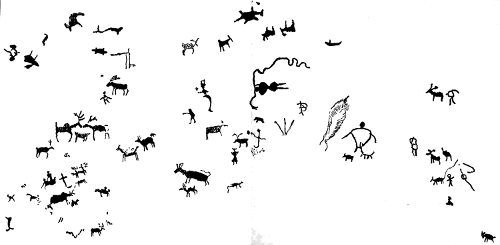
BUREAU OF ETHNOLOGY TENTH ANNUAL REPORT PL. XII PETROGLYPHS IN MAINE.
The rock upon which the glyphs appear is in the town of Machiasport, Maine, at Clarks point, on the northwestern side of Machias bay, 2 miles below the mouth of Machias river. The rock or ledge is about 50 feet long from east to west and about fifteen feet in width, nearly horizontal for two-thirds its length, from the bank or western end at high water, thence inclining at an angle of 15° to low-water mark. Its southern face is inclined about 40°. The formation is schistose slate, having a transverse vein of trap dike extending nearly across its section. Nearly the entire ledge is of blue-black color, very dense and hard except at the upper or western end, where the periodical formation of ice has scaled off thin layers of surface and destroyed many figures which are remembered by persons now living. The ebb and flow of tides, the abrasion of moving beach stones or pebble wash and of ice-worn bowlders, have also effaced many figures along the southern side, until now but one or two indentations are discernible. Visitors, in seeking to remove some portion of the rock as a curiosity or in striving to perpetuate their initials, have obscured several of the most interesting, and until recently the best defined figures. It was also evident to the present writer, who carefully examined the rock in 1888, that it lay much deeper in the water than once had been the case. At the lowest tides there were markings seen still lower, which could not readily have been made if that part of the surface had not been continuously exposed. The depression of a rock of such great size, which was so gradual that it had not been observed by the inhabitants of the neighboring settlement, is an evidence of the antiquity of the peckings.
The intaglio carving of all the figures was apparently made by repeated blows of a pointed instrument—doubtless of hard stone; not held as a chisel, but working by a repetition of hammerings or peckings. The deepest now seen is about three-eighths of an inch. The amount of patient labor bestowed upon these figures must have been great, considering the hardness of the rock and the rude implement with which they were wrought.
There is no extrinsic evidence of their age. The place was known to traders early in the seventeenth century, and much earlier was visited by Basque fishermen, and perhaps by the unfortunate Cortereals in 1500 and 1503. The descendants of the Mechises Indians, a tribal branch of the Abnaki, who once occupied the territory between the St. Croix and Narraguagus rivers, when questioned many years ago, would reply in substance that “all their old men knew of them,” either by having seen them or by traditions handed down through many generations.
Several years ago Mr. H. R. Taylor, of Machias, who made the original sketch in 1868 and kindly furnished it to the Bureau of Ethnology, applied to a resident Indian there (Peter Benoit, then nearly 80 years old) for assistance in deciphering the characters. He gave little information, but pointed out that the figures must not all be read “from one side only,” thus, the one near the center of the sketch, which seen from the south was without significance, became from the opposite point a squaw with sea fowl on her head, denoting, as he said, “that squaw had smashed canoe, saved beaver-skin, walked one-half moon all alone toward east, just same as heron wading alongshore.” Also that the three lines below the figure mentioned, which together resemble a bird track or a trident, represent the three rivers, the East, West, and Middle rivers of Machias, which join not far above the locality. The mark having a rough resemblance to a feather, next on the right of this river-sign, is a fissure in the rock. Most of the figures of human beings and other animals are easily recognizable.
Peckings of a character similar to those on the Picture rock at Clarks point, above described, were found and copied 600 feet south of it at high-water mark on a rock near Birch point. Others were discovered and traced on a rock on Hog island, in Holmes bay, a part of Machias bay. All these petroglyphs were without doubt of Abnaki origin, either of the Penobscot or the Passamaquoddy divisions of that body of Indians. The rocks lay on the common line of water communication between those divisions and were convenient as halting places.
MARYLAND.
In the Susquehanna river, about half a mile south of the state line, is a group of rocks, several of the most conspicuous being designated as the “Bald Friars.” Near by are several mound-shaped bowlders of the so-called “nigger-head” rock, which is reported as a dark-greenish chlorite schist. Upon the several bowlders are deep sculpturings, apparently finished by rubbing the depression with stone, or wood and sand, thus leaving sharp and distinct edges to the outlines. Some of these figures are an inch in depth, though the greater number are becoming more and more eroded by the frequent freshets, and by the running ice during the breaking up in early spring of the frozen river.
The following account is given by Prof. P. Frazer (a):
Passing the Pennsylvania state line one reaches the southern barren serpentine rocks, which are in general tolerably level for a considerable distance.
About 700 yards, or 640 meters, south of the line, on the river shore, are rocks which have been named the Bald Friars. French’s tavern is here, at the mouth of a small stream which empties into the Susquehanna. About 874 yards (800 meters) south of this tavern are a number of islands which have local names, but which are curious as containing inscriptions of the aborigines.
The material of which most of these islands are composed is chlorite schist, but as this rock is almost always distinguished by the quartz veins which intersect it, so in this case some of the islands are composed of this material almost exclusively, which gives them a very striking white appearance.
One of these, containing the principal inscriptions, is called Miles island.
The figures, which covered every part of the rocks that were exposed, were apparently of historical or at least narrative purport, since they seemed to be connected. Doubtless the larger portion of the inscription has been carried away by the successive vicissitudes which have broken up and defaced, and in some instances obliterated, parts of which we find evidence of the previous existence on the islands.
Every large bowlder seems to contain some traces of previous inscription, and in many instances the pictured side of the bowlder is on its under side, showing that it has been detached from its original place. The natural agencies are quite sufficient to account for any amount of this kind of displacement, for the rocks in their present condition are not refractory and offer no great resistance to the wear of weather and ice; but in addition to this must be added human agencies.
Amongst other things, they represent the conventional Indian serpent’s head, with varying numbers of lines.
Some of the signs next frequently recurring were concentric circles, in some cases four and in other cases a lesser number.
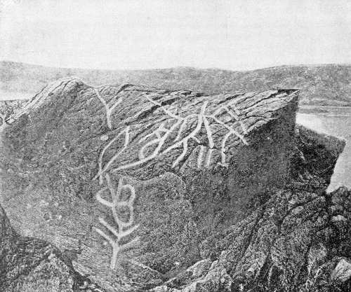
Fig. 45.—Bald Friar rock, Maryland.
Fig. 45 is a reproduction of Prof. Frazer’s illustration.
This region was also referred to by Dr. Charles Rau (a), his cut from the specimen in the collection of the Smithsonian Institution (Mus. No. 39010) being here reproduced as Fig. 46.