Chapter II · PETROGLYPHS IN NORTH AMERICA. (continued 2)
Reading edition
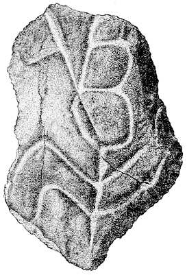
Fig. 46.—Slab from Bald Friar rock, Maryland.
During the autumn of the years 1888 and 1889 Dr. Hoffman visited these rocks, securing sketches and measurements, the former of which are reproduced in Figs. 47 and 48. The figures are deeply cut, as if rubbed down with sand and a round stick of green wood. The deepest channels, varying from three-fourths to 1¼ inches across and almost as deep as they are wide, appear as if cut out with a gouge, and for this reason bear a strong resemblance to the petroglyphs in Owens valley, California. In whatever manner these sculpturings were made, it is evident that much time and great labor were expended upon them, as this variety of rock, locally termed “Nigger-head,” is extremely hard.
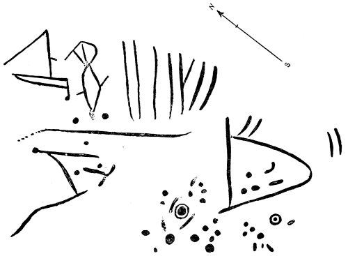
Fig. 47.—Top of Bald Friar rock, Maryland.
Fig. 45 represents a bird’s-eye view of the top of the rock, bearing the greater amount of workmanship. The petroglyphs cover a surface measuring about 5 feet by 4 feet 6 inches. The extreme ends of the figures extend beyond the irregular horizontal surface and project over the rounded edge of the rock, so that the line, at the left-hand lower part of the illustration, dips at an angle of about 45°. The two short lines at the extreme right are upon the side of the upper edge of the rock, where the surface inclines at an angle of 30°.
Some of the figures are indefinite, which is readily accounted for by the fact that the rock is in the river, a considerable distance from shore, and annually subjected to freshets and to erosion by floating logs and drift material. The characters at the right end of the upper row resemble those near Washington, Lancaster county, Pennsylvania. (See Fig. 73.)
Fig. 48 presents three characters, selected from other portions of the rock, to illustrate the variety of designs found. They are like some found at Owens valley, California, as will be observed by comparing them with the descriptions and plates under that heading in this section. The left-hand figure is 4 inches in diameter, the middle one 6 inches wide and about 15 inches in height, and the third, or right-hand, is composed of concentric rings, measuring about 10 inches across.

Fig. 48.—Characters from Bald Friar rock, Maryland.
MASSACHUSETTS.
The following description of the much-discussed Dighton rock is taken from Schoolcraft (b), where it is accompanied with a plate, now reproduced as Fig. 49:
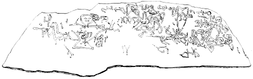
Fig. 49.—Dighton rock, Massachusetts.
The ancient inscription on a bowlder of greenstone rock lying in the margin of the Assonet or Taunton river, in the area of ancient Vinland, was noticed by the New England colonists so early as 1680, when Dr. Danforth made a drawing of it. This outline, together with several subsequent copies of it, at different eras, reaching to 1830, all differing considerably in their details, but preserving a certain general resemblance, is presented in the Antiquatés Americanes [sic] (Tables XI, XII), and referred to the same era of Scandinavian discovery. The imperfections of the drawings (including that executed under the auspices of the Rhode Island Historical Society in 1839, Table XII), and the recognition of some characters bearing more or less resemblance to antique Roman letters and figures, may be considered to have misled Mr. Magnusen in his interpretation of it. From whatever cause, nothing could, it would seem, have been wider from the purport and true interpretation of it. It is of purely Indian origin, and is executed in the peculiar symbolic character of the Kekeewin.
A number of copies of the inscriptions on this rock, taken at different times by different persons, are given below in Chapter XXII, sec. 2, with remarks upon them.
Dr. Hoffman visited the locality in 1886, and found that the surface was becoming rapidly destroyed from the frequent use of scrubbing with broom and water to remove the film of sand and dirt which is daily deposited by every tide, the rock being situated at a short distance inshore. Visitors are frequent, and the guide or ferryman does not interfere with them so long as he can show his passengers the famous inscription.
The resemblance between the characters on this rock and those found in western Pennsylvania, near Millsboro, Fig. 75, and south of Franklin, on the “Indian God rock,” Fig. 74, will be noted.
In Rafn’s Antiq. Amer. (b) is the following account:
A large stone, on which is a line of considerable length in unknown characters, has been recently found in Rutland, Worcester county, Massachusetts; they are regularly placed, and the strokes are filled with a black composition nearly as hard as the rock itself. The Committee also adds that a similar rock is to be found in Swanzy, county of Bristol and Commonwealth of Massachusetts, perhaps ten miles from the Dighton Rock.
MINNESOTA.
The late Mr. P. W. Norris, who was connected with the Bureau of Ethnology, reported large numbers of pecked totemic characters on the horizontal faces of the ledges of rock at Pipestone quarry in Minnesota, and presented some imitations of the peckings. There is a tradition that it was formerly the custom for each Indian who gathered stone (catlinite) for pipes, to inscribe his totem (whether clan or tribal or personal totem is not specified) upon the rock before venturing to quarry upon this ground. Some of the cliffs in the immediate vicinity were of too hard a nature to admit of pecking or scratching, and upon these the characters were placed in colors. Mr. Norris distinguished bird tracks, the outline of a bird resembling a pelican, deer, turtle, a circle with an interior cross, and a human figure.
Examples of so-called totemic designs from this locality are given in Fig. 50, which are reproduced from the work of R. Cronau (a):
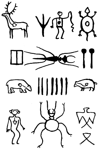
Fig. 50.—Petroglyphs at Pipestone, Minn.
The same petroglyphs and also others at the Pipestone quarry are described and illustrated by Prof. N. H. Winchell (a). A part of his remarks is as follows:
On the glaciated surface of the quartzite about the “Three Maidens,” which is kept clean by the rebound of the winds, are a great many rude inscriptions, which were made by pecking out the rock with some sharp-pointed instrument or by the use of other pieces of quartzite. They are of different sizes and dates, the latter being evinced by their manner of crossing and interfering and by the evident difference in the weight of the instruments used. They generally represent some animal, such as the turtle, bear, wolf, buffalo, elk, and the human form. The “crane’s foot” is the most common; next is the image of men; next the turtle. It would seem as if any warrior or hunter who had been successful and happened to pass here left his tribute of thanks to the great spirit in a rude representation of his game and perhaps a figure of himself on the rocks about these bowlders, or perhaps had in a similar way invoked the good offices of the spirits of his clan when about to enter on some expedition. In some cases there is a connection of several figures by a continuous line, chipped in the surface of the rock in such a manner as if some legend or adventure were narrated, but for the most part the figures are isolated. This is the “sacred ground” of the locality. Such markings can be seen at no other place, though there is abundance of bare, smooth rock. (Similar inscriptions are found on the red quartzite in Cottonwood county). The excavation of the surface of the rock is very slight, generally not exceeding a sixteenth of an inch, and sometimes only enough to leave a tracing of the designed form. The hardness of the rock was a barrier to deep sculpturing with the imperfect instruments of the aborigines; but it has effectually preserved the rude forms that were made. The fine glacial scratches that are abundantly scattered over this quartzite indicate the tenacity with which it retains all such impressions, and will warrant the assignment of any date to these inscriptions that may be called for within the human period. Yet it is probable that they date back to no very great antiquity. They pertain, at least, to the dynasty of the present Indian tribes. The totems of the turtle and the bear, which are known to have been powerful among the clans of the native races in America at the time of the earliest European knowledge of them, and which exist to this day, are the most frequent objects represented. The “crane’s foot,” or “turkey foot,” or “bird track,” terms which refer perhaps to the same totem sign—the snipe—is not only common on these rocks, but is seen among the rock inscriptions of Ohio, and was one of the totems of the Iroquois, of New York.
In June, 1892, Mr. W. H. Holmes, of the Bureau of Ethnology, visited the Pipestone quarry and took a number of tracings of the petroglyphs, which unfortunately were received too late for insertion in the present work. Some of his remarks are as follows:
The trouble with the figures copied and published by Prof. Winchell is that they are not arranged in the original order. It will now be impossible to correct this entirely, as most of the stones have been taken up and removed. * * * The Winchell drawings were evidently drawn by eye and have a very large personal equation; besides, they are mixed up while appearing to be in some order. The few groups that I was able to get are, it seems to me, of more interest than all the single figures you could put in a book. There can be little doubt that in the main this great group of pictures was arranged in definite order, agreeing with the arrangements of mythical personages and positions usual in the aboriginal ceremonials of the region. It is a great pity that the original order has been destroyed, but the inroads of relic hunters and inscription cranks made it necessary to take up the stones. One large stone was taken to Minneapolis by Prof. Winchell. There are a few pieces still in place. All were near the base of one of the great granite bowlders, and it is said here that formerly, within the memory of the living, the place was visited by Indians who wished to consult the gods.
The following description is extracted from the account of Mr. James W. Lynd (b):
Numerous high bluffs and cliffs surround it; the Pipestone quarry and the alluvial flat below these, in which the quarry is situated, contains a huge bowlder that rests upon a flat rock of glistening, smooth appearance, the level of which is but a few inches above the surface of the ground. Upon the portions of this rock not covered by the bowlder above and upon bowlder itself are carved sundry wonderful figures—lizards, snakes, otters, Indian gods, rabbits with cloven feet, muskrats with human feet, and other strange and incomprehensible things—all cut into the solid granite, and not without a great deal of time and labor expended in the performance. * * *
A large party of Ehanktonwanna and Teetonwan Dakotas, says the legend, had gathered together at the quarry to dig the stone. Upon a sultry evening, just before sunset, the heavens suddenly became overclouded by a heavy rumbling thunder and every sign of an approaching storm, such as frequently arises on the prairie without much warning. Each one hurried to his lodge, expecting a storm, when a vivid flash of lightning, followed immediately by a crashing peal of thunder, broke over them, and, looking towards the huge bowlder beyond their camp, they saw a pillar or column of smoke standing upon it, which moved to and fro, and gradually settled down into the outline of a huge giant, seated upon the bowlder, with one long arm extended to heaven and the other pointing down to his feet. Peal after peal of thunder, and flashes of lightning in quick succession followed, and this figure then suddenly disappeared. The next morning the Sioux went to this bowlder and found these figures and images upon it, where before there had been nothing, and ever since that the place has been regarded as wakan or sacred.
Mr. T. H. Lewis (b) gives a description of Fig. 51.
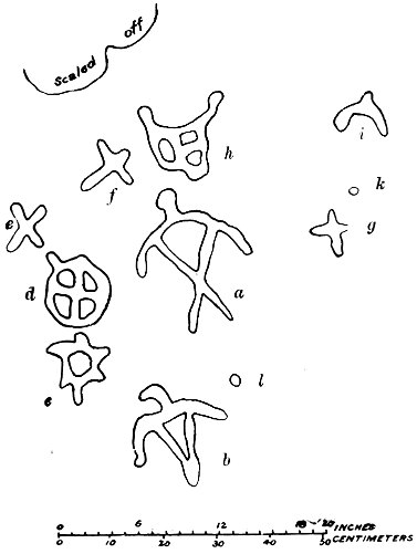
Fig. 51.—Petroglyphs in Brown’s valley, Minnesota.
This bowlder is in the edge of the public park, on the north end of the plateau at Brown’s valley, Minnesota. The bowlder has a flat surface with a western exposure, is irregular in outline, and is about 5 feet 8 inches in diameter, and firmly imbedded in the terrace.
The central figure, a, undoubtedly represents a man, although the form is somewhat conventional; b represents a bird; c represents a tortoise; d is a cross and circle combined, but the circle has a groove extending from it; e, f, and g, although somewhat in the shape of crosses, probably represent bird tracks; h and i are nondescript in character, although there must be some meaning attached to them; k and l are small dots or cups cut into the bowlder.
The figures as illustrated are one-eighth of their natural size, and are also correct in their relative positions one to the other. The work is neatly done although the depth of the incisions is very slight.
MONTANA.
Mr. Charles Hallock, of Washington, D. C., reports the occurrence of pictured rocks near Fort Assiniboin, Montana, but does not mention whether they are colored or incised, and also fails to describe the general type of the characters found.
NEBRASKA.
The following (condensed) description of petroglyphs found in Dakota county, Nebraska, is furnished by Mr. J. H. Quick, of Sioux City, Iowa:
The petroglyphs are found upon the face of a sandstone cliff in a deep ravine at a point where two watercourses (dry for the most part), meet about 20 miles south of Sioux City, Iowa, but in Dakota county, in the State of Nebraska. At this point the range of bluffs which bounds the Missouri river bottom is deeply cut through by the above-mentioned ravine, which runs in a northerly direction towards the Missouri. Another ravine coming from the southwest leaves this narrow point of land between the two ravines, rising to a height of 50 to 75 feet above the bottom of the ravines. For some distance from the point this cape, if I may so term it, shows ledges of sandstone cropping out on both sides. And exactly at the point and for some rods back on the east side are found the pictographs under consideration.
The rocks are of two kinds, a few feet of hard jasperous sandstone superimposed on about the same thickness of sandstone so soft that it can be crumbled to pieces in the fingers. The lower soft strata have been worn away, leaving the upper harder layers jutting out to a distance of several feet over and completely sheltering them. And on the smooth surface of these lower soft strata, protected by the overhanging ledge above, shut in by bluffs 200 feet high on the east and sheltered from the winds by dense underwood and scrubby forest trees, are carved these pictographs. These safeguards, combined with the advantage of a very secluded situation, have combined to preserve them, very little marred by careless and mischievous hands.
The eagle or “thunder-bird” figures are quite numerous. There are also many of the “buffalo track” and of the “turkey track” figures. I call them “turkey tracks” because they all show a spur and seem to represent some of the large gallinaciæ.
In one of the groups, which I will call the “bear-fight group,” we are at a loss to determine whether the figure of the small animal was a part of the original design or a subsequent interpolation. It seemed genuine, but was not so deeply carved as the other figures. The same may be said of the diagonal bars across the figure of the bear.
In the other group, which I will term the “turkey-track group,” there are some figures of which we could not even imagine the meaning. But they are undoubtedly genuine, and seem to belong to the same design as the other figure.
The “bear-track” figures are very numerous and of several different sizes. A cat-like figure, which we call a panther, shows faintly. It is about effaced by time. Other figures reminded us of a crab or crawfish, but we were unable to determine whether the line running back just below belongs to it or not.
I am informed by the same gentleman who saw these petroglyphs in 1857 that there were at one time many more some 3 or 4 miles from this place, near Homer, Nebraska, in the vicinity of a large spring, but he also said that as it is a favorite picnic ground for the country people the carvings are probably destroyed. I presume others may be found in these bluffs.
I surmise that the almost cave-like nature of the place where the carvings I have above attempted to describe are situated rendered it a favorite camping ground and resting place; and also that the ravines above mentioned made easy trails from the Missouri bottom up to the higher grounds farther from the river, because it obviated the ascent of the very steep bluffs.
The Winnebago Indian reservation is a few miles south of this locality, but they were placed here by the Government as late as from 1860 to 1865. Previous to that time I think this ground was occupied by the Omahas. I have been unable to gain any information as to the Indians who carved these figures or as to their meaning.
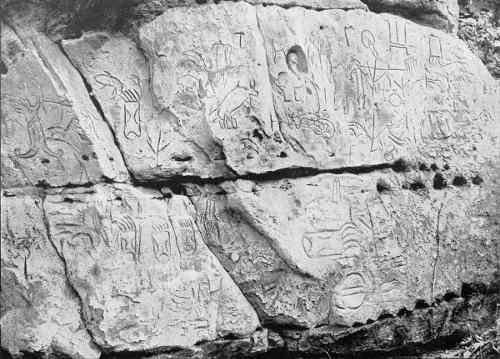
BUREAU OF ETHNOLOGY TENTH ANNUAL REPORT PL. XIII PETROGLYPHS IN NEBRASKA.
The most instructive of the petroglyphs, copies of which are kindly furnished by Mr. Quick, is presented as Pl. XIII, and selected sketches from that and the other petroglyphs copied are shown as Figs. 52 and 53.
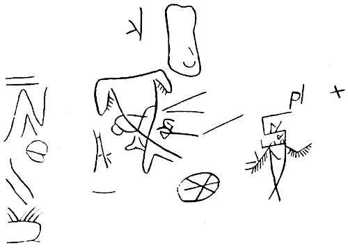
Fig. 52.—Characters from Nebraska petroglyphs.
Frank La Flèche, of the Bureau of Indian Affairs, in February, 1886, communicated the following:
Ingnanχe gikáχa-ina is the Omaha name of a rock ledge on the banks of the Missouri river, near the Santee agency, Nebraska. This ledge contains pictographs of men who passed to the happy hunting grounds, of life size, the sandstone being so soft that the engravings would be made with a piece of wood. They are represented with the special cause (arrow, gun, etc.), which sped them to hades. The souls themselves are said to make these pictographs before repairing “to the spirits.”
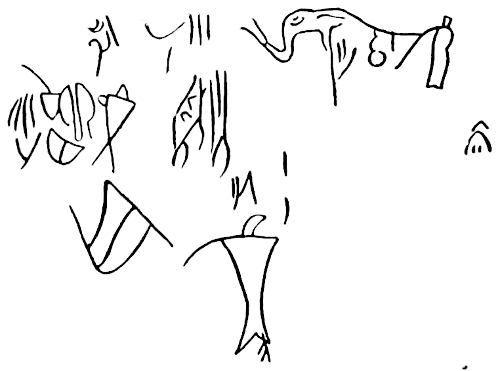
Fig. 53.—Characters from Nebraska petroglyphs.
Rev. J. Owen Dorsey, of the Bureau of Ethnology, says that the probable rendering of the term when corrected is, “Spirit(s) they-made-themselves the (place where).”
NEVADA.
Petroglyphs have been found by members of the U. S. Geological Survey at the lower extremity of Pyramid lake, Nevada, though no accurate reproductions are available. These characters are mentioned as incised upon the surface of basalt rocks.
Petroglyphs also occur in considerable numbers on the western slope of Lone Butte, in the Carson desert. All of these appear to have been produced on the faces of bowlders and rocks by pecking and scratching with some hard mineral material like quartz.
A communication from Mr. R. L. Fulton, of Reno, Nevada, tells that the drawing now reproduced as Fig. 54 is a pencil sketch of curious petroglyphs on a rock on the Carson river, about 8 miles below old Fort Churchill. It is the largest and most important one of a group of similar characters. It is basaltic, about 4 feet high and equally broad.
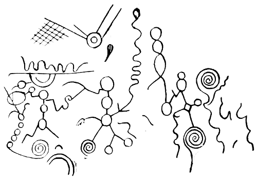
Fig. 54.—Petroglyphs on Carson river, Nevada.
Mr. Fulton gives the following description:
The rock spoken of has an oblong hole about 2 inches by 4 and 16 inches deep at the left end, which has been chipped out before the lines were drawn, if it was not some form of the ancient mill which is so common, as it seems to be the starting point for the whole scheme of the artist. The rock lies with a broad, smooth top face at an angle towards the south, and its top and southeast side are covered with lines and marks that convey to the present generation no intelligence whatever, so far as I can learn.
A line half an inch wide starts at the hole on the left and sweeping downward forms a sort of border for the work until it reaches midway of the rock, when it suddenly turns up and mingles with the hieroglyphics above. Two or three similar lines cross at the top of the stone, and one runs across and turns along the north side, losing itself in a coating of moss that seems as hard and dry and old as the stone itself. From the line at the bottom a few scallopy looking marks hang that may be a part of the picture, or it may be a fringe or ornament. The figures are not pictures of any animal, bird, or reptile, but seem to be made up of all known forms and are connected by wavy, snake-like lines. Something which might be taken for a dog with a round and characterless head at each end of the body, looking towards you, occupies a place near the lower line. The features are all plain enough. A deer’s head is joined to a patchwork that has something that might be taken for 4 legs beneath it. Bird’s claws show up in two or three places, but no bird is near them. Snaky figures run promiscuously through the whole thing. A circle at the right end has spokes joining at the center which run out and lose themselves in the maze outside.
The best known and largest collection of marks that I know of covers a large smooth ledge at Hopkins Soda Springs, 12 miles south of the summit on the Central Pacific railroad. The rock is much the same in character as those I have described, but the groundwork in this case is a solid ledge 10 feet one way and perhaps 40 the other, all closely covered with rude characters, many of which seem to point to human figures, animals, reptiles, etc. The ledge lies at an angle of 45°, and must have been a tempting place for a lazy artist who chanced that way.
Many other places on the Truckee river have such rocks all very much alike, and yet each bearing its own distinct features in the marking. Near a rock half a mile east of Verdi, a station on the Central Pacific railroad, 10 miles east of Reno, lie two others, the larger of which has lines originating in a hole at the upper right-hand corner, all running in tangents and angles, making a double-ended kind of an arrangement of many-headed arrows, pointing three ways. A snail-like scroll lies between the two arms, but does not touch them. Below are blotches, as if the artist had tried his tools.
This region has been roamed over by the Washoe Indians from a remote period, but none of them know anything of these works. One who has gray hair and more wrinkles than hairs, who is bent with age and who is said to be a hundred years old, was led to the spot. He said he saw them a heap long time ago, when he was only a few summers old, and they looked then just as they do now.
Mr. Lovejoy, a well-known newspaper man, took up, in 1854, the ranche where the rocks lie, and said just before his death that they were in exactly the same condition when he first saw them as they are to-day. Others say the same, and they are certainly of a date prior to the settlement of this coast by Americans and probably by the Spanish.
They are very peculiar in many respects, and the rock is wonderfully adapted to the uses to which it has been put. Wherever the surface has been broken the color has changed to gray, and no amount of wear or weather seems to turn it back. The indentation is so shallow as to be imperceptible to sight or touch, and yet the marks are as plain as they could be made, and can be seen as far as the rock can be distinguished from its fellows.
It is hardly likely that the work was done without some motive besides the simple love of doing it, and it was well and carefully done, too, showing much patience and doubtless consumed a good deal of time, as the tools were poor.
A large ledge is marked near Meadow lake in Nevada county, and in the state of Nevada the petroglyphs cover a route extending from the southeast to the northwest corner of the state, crossing the line into California in Modoc county, and leaving a string of samples clear across the Madeline plains.
Eight miles below Belmont, in Nye county, Nevada, an immense rock which at some time has fallen into the canyon from the porphyry ledge above it has a patch of marks nearly 20 feet square. It is so high that a man on horseback can not reach the top.
A number at Reveillé, in the same county, are also marked. On the road to Tybo every large rock is marked, one of the figures being a semicircle with a short vertical spoke within the curve. At Reno a heavy black rock a couple of feet across is beautifully engraved to represent a bull’s eye of 4 rings, an arrow with a very large feather, and one which may mean a man. In a steep canyon 15 miles northeast of Reno, in Spanish Spring mountains, several cliffs are well marked, and an exposed ledge, where the Carson river has cut off the point of a hill below Big Bend, is covered with rings and snakes by the hundred. Several triangles, a well-formed square and compass, a woman with outstretched arms holding an olive branch, etc., are there.
Humboldt county has its share, the best being on a bluff below the old Sheba mine. Ten miles south of Pioche are about 50 figures cut into the rock, many of them designed to represent mountain sheep. Eighty miles farther south, near Kane’s Spring, the most numerous and perfect specimens of this prehistoric art are found. Men on horseback engaged in the pursuit of animals are among the most numerous, best preserved, and carefully executed.
The region I have gone over is of immense size, and must impress everyone with the importance of a set of symbols which extends in broken lines from Arizona far into Oregon.
Fig. 55 exhibits engravings at Reveillé, Nevada. Great numbers of incised characters of various kinds are also reported from the walls of rocks flanking Walker river, near Walker lake, Nevada. Waving lines, rings, and what appear to be vegetable forms are of frequent occurrence. The human form and footprints are also depicted.
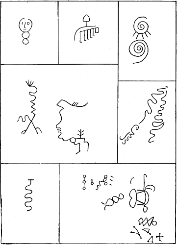
Fig. 55.—Petroglyphs at Reveillé, Nevada.
Fig. 56 is a copy of a drawing made by Lieut. A. G. Tassin, Twelfth U. S. Infantry, in 1877, of an ancient rock-carving at the base and in the recesses of Dead mountain and the abode of dead bad Indians according to the Mohave mythology. This drawing and its description is from a manuscript report on the Mohave Indians, in the library of the Bureau of Ethnology, prepared by Lieut. Tassin.
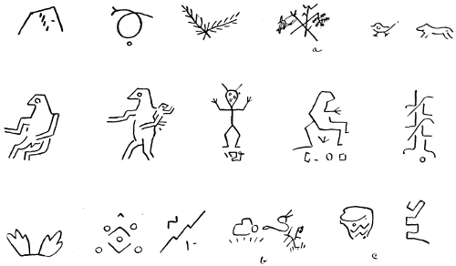
Fig. 56.—Petroglyphs at Dead mountain, Nevada.
He explains some of the characters as follows:
(a) Evidently the two different species of mesquite bean.
(b) Would seem to refer to the bite of the cidatus, and to the use of a certain herb for its cure.
(c) Presumably the olla or water cooler of the Mohaves.
The whole of this series of petroglyphs is regarded as being Shinumo or Moki. They show a general resemblance to drawings in Arizona, known to have been made by the Moki Indians. The locality is within the territory of the Shoshonean linguistic division, and the drawings are in all probability the work of one or more of the numerous tribes comprised within that division.
NEW MEXICO.
On the north wall of Canyon de Chelly, one-fourth of a mile east of its mouth, are several groups of petroglyphs, consisting chiefly of various grotesque forms of the human figure, and also numbers of animals, circles, etc. A few of them are painted black, the greater portion consisting of rather shallow lines, which are in some places considerably weathered. Further up the canyon, in the vicinity of the cliff dwellings, are numerous small groups of pictographic characters, consisting of men and animals, waving or zigzag lines, and other odd figures.
Lieut. James H. Simpson (a), in his Journal of a Military Reconnoissance, etc., presents a number of plates bearing copies of inscriptions on rocks in the northwestern part of New Mexico, among which are those on the so-called “Inscription rock” at El Moro, here reproduced as Fig. 57. The petroglyphs are selected from the south face of the rock. Lieut. Simpson states that most of the characters are no higher than a man’s head, and that some of them are undoubtedly of Indian origin.
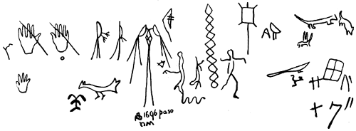
Fig. 57.—Inscription rock, New Mexico.
Among the many colored etchings and paintings on rock discovered by the Pacific railroad expedition in 1853-’54, Lieut. Whipple (c) notes those at Rocky dell creek, New Mexico, which were found between the edge of the Llano Estacado and the Canadian river. The stream flows through a gorge, upon one side of which a shelving sandstone rock forms a sort of cave. The roof is covered with paintings, some evidently ancient, and beneath are innumerable carvings of footprints, animals, and symmetrical lines. He also remarks (d) that figures cut upon a rock at Arch spring, near Zuñi, present some faint similarity to those at Rocky dell creek.
Near Ojo Pescado, in the vicinity of the ruins, are petroglyphs, also reported by Lieut. Whipple (d), which are very much weather-worn and have “no trace of a modern hand about them.”
Mr. Edwin A. Hill, of Indianapolis, in a letter, notes petroglyphs on the Denver and Rio Grande railroad, between Antonite and Espanola. Below Tres Piedras and near Espanola are rude sculptures, lining the valley on both sides of the road for a long distance, at least several miles. The canyon has a slope of about 45° and contains many bowlders, and on every available face pictographs are cut. Figures of arrows, hatchets, circles, triangles, bows, spears, turtles, etc., are outlined as if with some cutting-tool. The country had two years before been occupied by Apaches, but far greater age is attributed to the petroglyphs.
Other petroglyphs actually within the geographical area of New Mexico are so near the border that they are treated of in connection with those of Colorado.
Prof. E. D. Cope (a) gives a copy of figures which he found on the side of a ravine near Abiquiu, on the river Chama. They are cut in Jurassic sandstone of medium hardness, and are quite worn and overgrown with the small lichen which is abundant on the face of the rock.
Mr. Gilbert Thompson, of the U. S. Geological Survey, reports his observation of petroglyphs at San Antonio springs, 30 miles east of Fort Wingate, New Mexico. The human figure, in various forms, occurs, as well as numerous other characters, strikingly similar to those frequent in the country farther west occupied by the Moki Indians. The peculiarity of these figures is that the outlines are incised and that the depressions thus formed are filled with red, blue or white pigments. The interior of the figures is simply painted with one or more of the same colors.
Figs. 58 and 59 are reproductions of drawings of petroglyphs from Ojo de Benado, south of Zuñi, New Mexico. The manuscripts which once accompanied them, and which were forwarded to the Bureau of Ethnology in the usual official manner, have become separated from the sketches, and on those there are no indications of the collectors’ names.
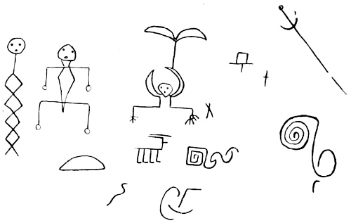
Fig. 58.—Petroglyphs at Ojo de Benado, New Mexico.
The characters are very like others from several localities in the territory and in the adjacent region. The type is that of the Pueblos generally.
Mr. Bandelier, in conversation, reported having seen and sketched a petroglyph at Nambe, in a canyon about 2 miles east of the pueblo, also another at Cueva Pintada, about 17 miles by the trail northwest of Cochiti.
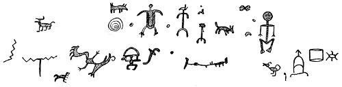
Fig. 59.—Petroglyphs at Ojo de Benado, New Mexico.
NEW YORK.
The following is extracted from Schoolcraft (c):
There is a pictographic Indian inscription [now obliterated] in the valley of the Hudson, above the Highlands, which from its antiquity and character appears to denote the era of the introduction of firearms and gunpowder among the aboriginal tribes of that valley. This era, from the well-known historical events of the contemporaneous settlement of New Netherlands and New France, may be with general accuracy placed between the years 1609, the date of Hudson’s ascent of that stream above the Highlands, and the opening of the Indian trade with the Iroquois at the present site of Albany, by the erection of Fort Orange, in 1614. * * *
In a map published at Amsterdam, in Holland, in 1659, the country, for some distance both above and below Esopus creek, is delineated as inhabited by the Waranawankongs, who were a totemic division or enlarged family clan of the Mohikinder. They spoke a well-characterized dialect of the Mohigan, and have left numerous geographical names on the streams and physical peculiarities of that part of the river coast quite to and above Coxsackie. The language is Algonquin.
Esopus itself appears to be a word derived from Seepu, the Minsi-Algonquin name for a river.
* * * The inscription may be supposed, if the era is properly conjectured, to have been made with metallic tools. The lines are deeply and plainly impressed. It is in double lines. The plumes from the head denote a chief or man skilled in the Indian medico-magical art. The gun is held at rest in the right hand; the left appears to support a wand. [The position of the arm may be merely a gesture.]
The reproduction here as Fig. 60 is from a rock on the western bank of the Hudson, at Esopus landing. It is presented mainly on account of the frequent allusions to it in literature.
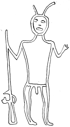
Fig. 60.—Petroglyph at Esopus, New York.
NORTH CAROLINA.
Mr. James Mooney, of the Bureau of Ethnology, reports petroglyphs upon a gray gneissoid rock, a short distance east of Caney river, on the north side of the road from Asheville to Burnsville, North Carolina. The face of the surface is at an angle of 30° toward the south, and the sculptured area covers about 10 feet square. The characters consist chiefly of cup-shaped depressions, some about 2 inches deep, some being also connected. There are a few markings which appear to have been intended to represent footprints. The characters resemble, to some extent, those at Trap Rock gap, Georgia, and at the Juttaculla rock, North Carolina, on a branch of the Tuckasegee river, above Webster.
The above-described sculptured rock is on the property of Ellis Gardner, and is known as Gardner’s, or the “Garden rock.”
Mr. Mooney also reports that at Webster, North Carolina, there is one large rock bearing numerous petroglyphs, rings, cup-shaped depressions, fish-bone patterns, etc. He further states, upon the authority of Dr. J. M. Spainhour, of Lenoir, that upon a light gray rock measuring 4 feet by 30 are numerous cup-shaped petroglyphs, he having counted 215. The rock is on the Yadkin river, 4 miles below Wilkesboro, and is at times partly under water.
Dr. Hoffman, who in 1886 visited western North Carolina, gives the following account of colored pictographs found there by him.
“The locality known as ‘Paint rock’ is situated on the east or right bank of the French Broad river, about 100 yards above the Tennessee and North Carolina state line. The limestone cliff, which terminates abruptly near the river, measures about 100 feet in height and covers an area from side to side of exposure of at least 100 yards. The accompanying view (Fig. 61), taken from across the river, presents the wall of limestone rock and the position of the petroglyph, which is delineated in proper proportion nearly in the center of the illustration.
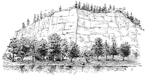
Fig. 61.—Paint rock, North Carolina.
“The property belongs to Mr. J. W. Chockley, who has been living in the vicinity for about fifteen years. He states that during this time the pictograph has undergone some change on account of gradual disintegration or fracture of the rock. The first knowledge of the pictograph, according to local tradition, dates back about sixty years, and no information as to its import could be learned, either from the white residents, who are few in number, or the straggling Cherokee Indians who visit the railway station at odd intervals.”
The pictograph is peculiar in design, no animal forms being apparent but an indefinite number of short, straight lines at right angles to one another, as shown in Fig. 62. One-thirty-sixth actual size.
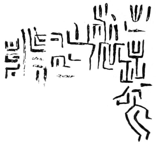
Fig. 62.—Petroglyphs on Paint rock, North Carolina.
The characters are in dark red, probably a ferrous oxide, quantities of which are found in the neighborhood. The color appears to have penetrated the softer portions of the limestone, though upon the harder surfaces it has been removed by exposure to the elements. The lowermost figure appears to resemble a rude outline of a human form, with one arm lowered and reaching forward, though this is only a suggestion.
Upon the face of the rock, a few yards to the right of the above, are indistinct outlines of circles, several of which indicate central spots, and one, at least, has a line extending from the center downward for about 8 inches.
OHIO.
A large number of petroglyphs are reported from this state. It is sufficient to present the following examples extracted, with reproduced illustrations and abbreviated descriptions, from the Report of the Committee of the State Archæological Society, published in the Report of the Ohio State Board of Centennial Managers.
Fig. 63 is a copy of the petroglyph on the Newark Track rock.
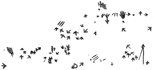
Fig. 63.—Newark Track rock, Ohio.
It is described in the volume cited, pages 94, 95, as follows:
The inscriptions near Newark, in Licking county, Ohio, originally covered a vertical face of conglomerate rock, 50 or 60 feet in length, by 6 and 8 feet in height. This rock is soft and, therefore, the figures are easily erased * * *. About the year 1800 it became a place where white men sought to immortalize themselves by cutting their names across the old inscription * * *.
On the rock faces and detached sandstone blocks of the banks of the Ohio river there are numerous groups of intaglios, but in them the style is quite different from those to which I have referred, and which are located in the interior. Those on the Ohio river resemble the symbolical records of the North American Indians, such as the Kelley Island stone, described in Schoolcraft by Capt. Eastman, the Dighton rock, the Big Indian rock of the Susquehanna, and the “God rock” of the Allegheny river. In those the supposed bird track is generally wanting. The large sculptured rock near Wellsville, which is only visible at low water of the Ohio, has among the figures one that is prominent on the Barnesville stones. This is the fore foot of the bear, with the outside toe distorted and set outward at right angles.
Other sculptured rocks of a similar character have been found in Fairfield, Belmont, Cuyahoga, and Lorain counties.
That the ancient bird-track character belonged to the mound-builders is evident from the fact that it is found among their works, constructed of soil on a large scale.
One of these bird-track mounds occurs in the center of the large circular inclosure near Newark, Ohio, now standing in the Licking county fair grounds. Among the characters will be noticed the human hand. In one instance the hand is open, the palm facing the observer, and in the other the hand is closed, except the index finger which points downward to the base of the cliff. Of the bird-track characters there are many varieties. There is also a character resembling a cross and another bearing some resemblance to an arrow.
Fig. 64 is an illustration of the Independence stone, which is described in the same volume, pp. 98, 99, as follows:
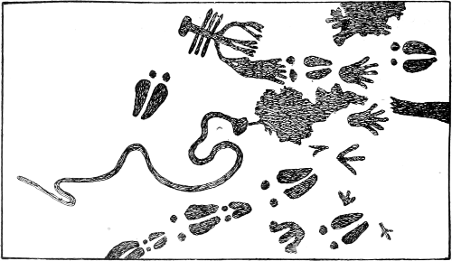
Fig. 64.—Independence stone, Ohio.
Great care has been taken to obtain a correct sketch of what remains of this inscription. A very rude drawing of it was published in Schoolcraft’s great work upon the Indian tribes, in 1854.
The rock here described only contains a portion of the inscription. The balance was destroyed in quarrying. The markings on the portion of the rock preserved consist of the human foot, clothed with something like a moccasin or stocking; of the naked foot; of the open hand; of round markings one in front of the great toe, of each representation of the clothed foot; the figure of a serpent, and a peculiar character which might be taken for a rude representation of a crab or crawfish, but which bears a closer resemblance to an old-fashioned spearhead used in capturing fish.
Fig. 65 is a copy of the drawings on the Track rock, near Barnesville, Belmont county, Ohio, the description of which is in the same volume, pp. 89-93.
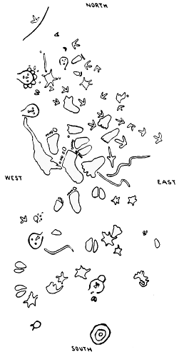
Fig. 65.—Barnesville Track rock, Ohio.
The rude cuts of the human faces, part of the human feet, the rings, stars, serpents, and some others, are evidently works of art, as in the best of them the marks of the engraving instrument are to be seen. In all cases, whether single or in groups, the relative dimensions of the figures are preserved. The surface of this block is 8 by 11 feet.
At the south end of the petroglyphs occurs a figure of several concentric rings, a design by no means confined to Ohio. The third figure right of this resembles others in the same group, and evidently indicates the footprints of the buffalo. Human footprints are generally indicated by the pronounced toe marks, either detached as slight depressions or attached to the foot, and are thus recognized as different from bear tracks, which frequently have but slight indications of toes or perhaps claw marks, and in which also the foot is shorter or rounder. The arrow-shaped figures are no doubt intended for turkey tracks, characters common to many petroglyphs of the middle and eastern Algonquian area.
Fig. 66 gives several of the above characters enlarged from the preceding figure.
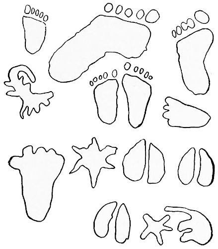
Fig. 66.—Characters from Barnesville Track rock.
In Fig. 67, referring to another block mentioned in the same report, lying 20 feet south of the one first mentioned, there is a duplication of the characters before noted—human footprints, bear and turkey tracks, and the indication of what may be intended to represent a serpent.
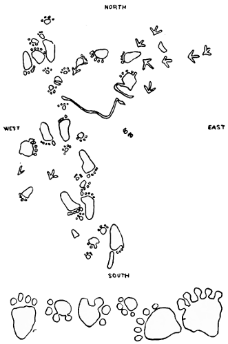
Fig. 67.—Barnesville Track rock, No. 2.
Fig. 68, from p. 105 of the same volume, gives copies of sketches from the rocks near Wellsville, Ohio, with remarks as follows:
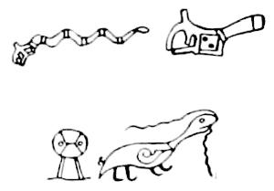
Fig. 68.—Petroglyphs, Wellsville, Ohio.
On the Ohio side of the river, 1 mile above Wellsville, there is a large group of sculptures on a flat sand rock of the coal series, scarred by floating ice and flood wood. They are only visible in low water, as they are only 2 or 3 feet above the extreme low stage of the river. * * * They are made in double outline and not by a single deep channel. The outlines are a series of dots made with a round-pointed instrument, seldom more than half an inch deep.
The upper design is a rattlesnake with a fancy head and tail. Its length is 4½ feet, a very clumsy affair, but intended for the common yellow rattlesnake of the West. The head of the snake, which occupies a space 6 inches square, is represented in the second character, which is reduced from a tracing size of nature. It brings to mind the horned snake of the Egyptians, which was an object of worship by them.
The character at the left hand of the lower line may be an uncouth representation of a demon or evil spirit. The right-hand character is probably an otter carrying a vine or string in his month.
It is more probable that the lines from the mouth of the animal indicate magic or supernatural power, of which many examples appear in this paper, as also of the device in the region of the animal’s heart, from which a line extends to the mouth. These characteristics connect the glyph with the Ojibwa drawings on bark.
OREGON.
Many bowlders and rock escarpments at and near the Dalles of the Columbia river, Oregon, are covered with incised or pecked glyphs. Some of them are representations of human figures, but characters of other forms predominate.
Mr. Albert S. Gatschet, of the Bureau of Ethnology, reports the discovery by him, in 1878, of rock etchings 4 miles from Gaston, Oregon, and 2½ miles from the ancient settlement of the Tuálati (or Atfálati) Indians. These etchings are about 100 feet above the valley bottom on six rocks of soft sandstone, projecting from the grassy hillside of Patten’s valley, opposite Darling Smith’s farm, and are surrounded with timber on two sides.
This sandstone ledge extends for one-eighth of a mile horizontally along the hillside, upon the projecting portions of which the inscriptions are found. These rocks differ greatly in size, and slant forward so that the inscribed portions are exposed to the frequent rains of that region. The first rock, or that one nearest the mouth of the canyon, consists of horizontal zigzag lines and a detached straight line, also horizontal. On another side of the same rock is a series of oblique parallel lines. Some of the most striking characters found upon other exposed portions of the rock appear to be human figures, i. e., circles to which radiating lines are attached, and bear indications of eyes and mouth, long vertical lines running downward as if to represent the body, and terminating in a furcation, as if intended for legs, toes, etc. To the right of one figure is an arm and three-fingered hand (similar to some of the Moki characters), bent downward from the elbow, the humerus extending at a right angle from the body. Horizontal rows of short vertical lines are placed below and between some of the figures, probably numerical marks of some kind.
Other characters occur of various forms, the most striking being an arrow pointing upward, with two horizontal lines drawn across the shaft, and with vertical lines having short oblique lines attached thereto.
Mr. Gatschet remarks that the Tuálati tell a trivial story to explain the origin of these pictures, the substance of which is as follows: The Tillamuk warriors living on the Pacific coast were often at variance with the several Kalapuya tribes. One day, passing through Patten’s valley to invade the country of the Tuálati, they inquired of a woman how far they were from their camp. The woman, desirous not to betray her own countrymen, said they were yet at a distance of one (or two?) days’ travel. This made them reflect over the intended invasion, and, holding a council, they decided to withdraw. In commemoration of this the inscription, with its numeration marks, was incised by the Tuálati.
Dr. Charles Rau received from Dr. James S. Denison, physician at the Klamath agency, Lake county, Oregon, a communication relative to the practice of painting figures on rocks in the territory of the Klamath Indians in Oregon. There are in that neighborhood many rocks bearing painted figures; but Dr. Rau’s (b) description refers specially to a single rock, called Ktá-i Tupákshi (standing rock), situated about 50 yards north of Sprague river and 150 yards from the junction of Sprague and Williamson rivers. It is about 10 feet high, 14 feet long, and 12 or 14 feet deep. Fig. 69, drawn one-twelfth of the natural size, illustrates the character of the paintings seen on the smooth southern surface of this rock. The most frequent designs are single or concentric circles, like Fig. 69, a, which consists of a dark red circle surrounded by a white one, the center being formed by a round red spot. Fig. 69, b, painted in dark red and white colors, exhibits a somewhat Mahadeo-like shape; the straight appendage of the circle is provided on each side with short projecting lines, alternately red and white, and almost producing the effect of the so-called herring-bone ornament.
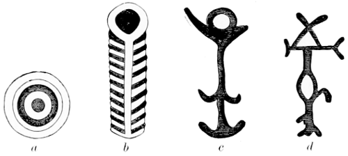
Fig. 69.—Petroglyphs in Lake county, Oregon.
Fig. 69, c and d, executed in dark red, are other designs seen on the standing rock above mentioned. The colors, which, as the informant thinks, are rubbed in with grease, appear quite distinct on the dark surface of the rock.
PENNSYLVANIA.
Along the river courses in northern and western Pennsylvania many rocks are found bearing traces of carvings, though, on account of the character of the geological formations, some of them are nearly obliterated.
In 1875 Mr. P. W. Shafer published in a historical map of Pennsylvania several groups of pictographs. These had before appeared in a rude and crowded form in the Transactions of the Anthropological Institute of New York, 1871-’72, page 66, where the localities are mentioned as “Big” and “Little” Indian rocks, respectively. One of these rocks is in the Susquehanna river, below the dam at Safe harbor, and the drawing clearly shows its Algonquian origin. The characters are nearly all either animals or various forms of the human body. Birds, bird tracks, and serpents also occur. A part of this pictograph is presented below, Fig. 1089.
Dr. W. J. Hoffman visited this place during the autumn of 1889 and made sketches of the petroglyphs. The Algonquian type of delineation of objects is manifest.
The rock known as “Big Indian rock” is in the Susquehanna river, three-fourths of a mile below the mouth of Conestoga creek and about 400 yards from the eastern bank of the Susquehanna. It is one of many, but larger than any other in the immediate vicinity, measuring about 60 feet in length, 30 feet in width, and an average height of about 20 feet. The upper surface is uneven, though smoothly worn, and upon this are pecked the characters, shown in Fig. 70.
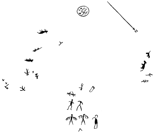
Fig. 70.—Big Indian rock, Pennsylvania.
The characters, through exposure to the elements, are becoming rather indistinct, though a few of them are pecked so deep that they still present a depression of from one-fourth to one-half an inch in depth. The most conspicuous objects consist of human figures, thunder birds, and animals resembling the panther.
“Little Indian rock” is also situated in the Susquehanna river, one-fourth of a mile from the eastern bank and a like distance below the mouth of Conestoga creek. This rock, also of hard micaceous schist, is not so large as the one above mentioned, but bears more interesting characters, the most conspicuous being representations of the thunder bird, serpents, deer and bird tracks, etc.
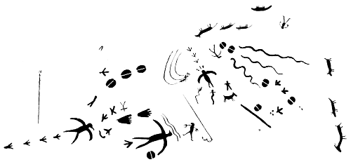
Fig. 71.—Little Indian rock, Pennsylvania.
Prof. Persifor Frazer, jr., (b) remarks upon the gradual obliteration of these pictographs, and adds:
In addition to these causes of obliteration it is a pity to have to record another, which is the vandalism of some visitors to the locality who have thought it an excellent practical joke to cut spurious figures alongside of and sometimes over those made by the Indians. It is not unlikely, too, that the “fish pots” here, as in the case of the Bald Friar’s inscriptions, a few miles below the Maryland line, may have been constructed in great part out of fragments of rock containing these hieroglyphics, so that the parts of the connected story which they relate are separated and the record thus destroyed.
Others have cut their initials or full names in these rocks, thus for an obscure record whose unriddling would award the antiquarian, substituting one, the correct deciphering of which leads to obscurity itself.
At McCalls ferry, on the Susquehanna river, in Lancaster county, and on the right shore near the water’s edge, is a gray gneissoid flat rock, bearing petroglyphs that have been pecked upon the surface. It is irregular in shape, measuring about 3½ by 4 feet in superficial area, upon which is a circle covering nearly the entire surface, in the middle of which is a smaller circle with a central point. On one side of the inner space, between the outer and inner circles, are a number of characters resembling human figures and others of unintelligible form. The petroglyph is represented in Fig. 72.
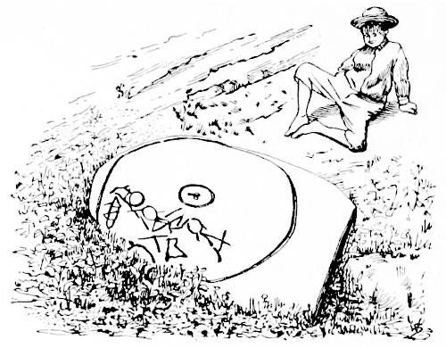
Fig. 72.—Petroglyph at McCalls ferry, Pennsylvania.
The resemblance between these drawings and those on Dighton rock is to be noted, as well as that between both of them and some in Ohio. All those localities are within the area formerly occupied by tribes of the Algonquian stock.
Near Washington, Lancaster county, Pennsylvania, on “Mill stream,” one-fourth of a mile above its junction with the Susquehanna river, is a large bowlder of gray sandstone (Fig. 73), the exposed portion of which bears several deeply incised lines which appear to have served as topographic indicators, as several others of like kind occur farther downstream. The longest incision is about 28 inches in length, the next one parallel to it, about 14 inches, while the third character is V-shaped, one arm of which is about 10 inches in length and the other 12. The apex of this character points in a southeast direction.
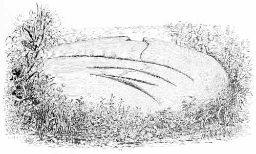
Fig. 73.—Petroglyph near Washington, Pennsylvania.
One-eighth of a mile farther down is another bowlder, also near the water, which bears shorter lines than the preceding, but in general pointing almost southeast and northwest.
The workmanship is similar to that at Conowingo, Maryland, at the site of the Bald Friar rocks. The marks appear to have been chipped to a considerable depth and then rubbed with sand and some hard substance so as to present a smooth and even surface, removing all or nearly all of the pecked surface.
Mr. P. W. Shafer, on the same historical map of Pennsylvania before mentioned, presents also a group of pictures copied from the originals on the Alleghany river, in Venango county, 5 miles south of Franklin, on what is known as the Indian God rock. There are but six characters furnished in his copy, three of which are variations of the human form, while the others are undetermined.
This rock was visited in 1886 by Dr. Hoffman, who made a number of drawings of objects represented, of which only those in Fig. 74 are here reproduced. The face of the bowlder bearing the original petroglyphs has been much disfigured by visitors who, in endeavoring to display their skill by pecking upon the surface names, dates, and other designs, have so injured it that it is difficult to trace the original characters.
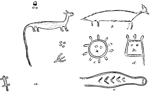
Fig. 74.—Petroglyphs on “Indian God rock.”
Fig. 74, a, represents, apparently, a panther. Above and beneath it are markings resembling wolf tracks, while farther down is a turkey track, and in the left-hand lower corner is a human form, such as is usually found upon rocks in the areas represented by Shoshonian tribes.
The design at b is much mutilated and eroded, and may originally have been a character like a, the first of this series.
The characters at c and d are evidently human faces, the former representing that of the sun, the latter being very much like a mask. That at e is found upon other Algonquian rocks, notably those called “Bald Friar,” Maryland, in the Susquehanna river, immediately below the state line of Pennsylvania.
The bowlder upon which these petroglyphs are engraved lies at the water’s edge, and during each freshet the lower half of the surface and sometimes even more is under water. At these times floating logs, impelled according to the curve in the river immediately above, are directed toward this rock, which may explain the worn surface and the eroded condition of the sculpture.
Mr. J. Sutton Wall, of Monongahela city, describes in correspondence a rock bearing pictographs opposite the town of Millsboro, in Fayette county, Pennsylvania. This rock is about 390 feet above the level of the Monongahela river, and belongs to the Waynesburg stratum of sandstone. It is detached and rests somewhat below its true horizon. It is about 6 feet in thickness, and has vertical sides; only two figures are carved on the sides, the principal inscriptions being on the top, and all are now considerably worn. Mr. Wall mentions the outlines of animals and some other figures formed by grooves or channels cut from an inch to a mere trace in depth. No indications of tool marks were discovered. The footprints are carved depressions. The character marked z, near the lower left-hand corner, is a circular cavity 7 inches deep. A copy of the inscription made in 1882 by Mr. Wall and Mr. William Arison is reproduced as Fig. 75.
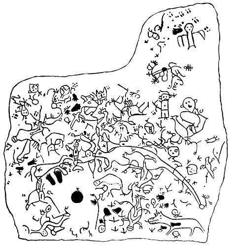
Fig. 75.—Petroglyph at Millsboro, Pennsylvania.
Again the resemblance between these drawings, those on Dighton rock, and some of those in Ohio, introduced above, is to be noted, and the fact that all these localities are within the area formerly occupied by tribes of the Algonquian stock.
Mr. Wall also contributes a group of glyphs on what is known as the “Geneva Picture rock,” in the Monongahela valley, near Geneva. These are footprints and other characters similar to those from Hamilton farm, West Virginia, which are shown in Fig. 1088.
Mr. L. W. Brown, of Redstone, Fayette county, Pennsylvania, mentions a rock near Layton, in that county, which measures about 15 by 25 feet in area, upon the surface of which occur a number of petroglyphs consisting of the human figure, animals, and footprints, some of which are difficult to trace. From a rough sketch reproduced as Fig. 76, made by Mr. Brown, these appear to be Algonquian in type.
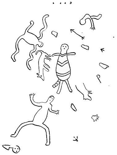
Fig. 76.—Petroglyphs near Layton, Pennsylvania.
Mr. Brown also submitted for examination two pieces of chocolate-colored, smooth, fine grained slate, of hard texture, bearing upon the several sides outlines of incised figures. The specimens were found in Indian graves in Fayette county, Pennsylvania. The outline of the incisions, although they are not strictly petroglyphs, are reproduced in Figs. 77 and 78.
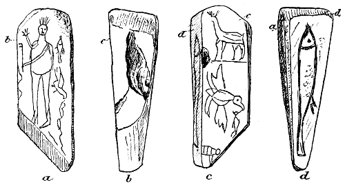
Fig. 77.—Glyphs in Fayette county, Pennsylvania.
The designs are made in delicate lines, as if scratched with a sharply pointed piece of quartz, or possibly metal. The character d on Fig. 78 is the representation of a fish, which has been accentuated by additional cutting since found. The characters resemble the Algonquian type, many of them being frequently found among those tribes living along the Great Lakes.
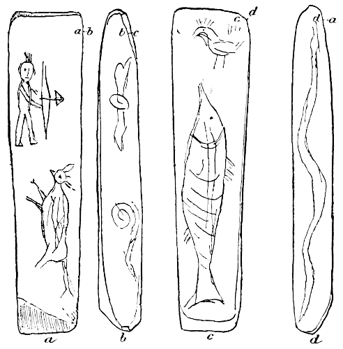
Fig. 78.—Glyphs in Fayette county, Pennsylvania.
RHODE ISLAND.
In C. C. Rafn’s Antiq. Amer. (c), is the following account:
Portsmouth rocks.—The rocks, for there are several of them, are situated on the western side of the island of Rhode Island, in the town of Portsmouth, on the shore, about 7 miles from Newport, taking the western road, and 4 miles from Bristol ferry. * * * They are partially, if not entirely, covered by water at high tide; and such was the state of the tide and the lateness of the hour when the location was ascertained, that I was unable to make a thorough examination of them. I saw sufficient, however, to satisfy me that they were formerly well covered with characters, although a large portion of them have become obliterated by the action of air and moisture, and probably still more by the attrition of masses of stone against them in violent storms and gales, and by the ruthless ravages of that most destructive power of all, the hand of man.
Tiverton rocks [op. cit. d].—Their situation may be thus known: by tracing along the east side of the map of Rhode Island until you strike Tiverton, and then following along to the southwest extremity of that town, the Indian name Puncoteast, also the English names Almy and High Hill, will be seen. The inscriptions are on masses of Graywacke. * * * We can only state they were occupied with some kind of characters.
These two inscriptions are pictured, op. cit., Table XIII.
SOUTH DAKOTA.
Mr. T. H. Lewis (c), gives a description of Fig. 79 as follows:
This bowlder is on a high terrace on the west side of the Minnesota river, 1½ miles south of Browns valley, and is in Roberts county, South Dakota. It is oblong in form, being 3½ feet in length, 2 feet in width, and is firmly imbedded in the ground.
Of the characters a and b are undoubtedly tortoises; c is probably intended to represent a bird track; d represents a man, and is similar to the one at Browns valley, Minnesota, [Fig. 51, supra;] e is a nondescript of unusual form; f is apparently intended to represent a headless bird, in that respect greatly resembling certain earthen effigies in the regions to the southeast.
The figures are about one-fourth of an inch in depth and very smooth, excepting along their edges, which roughness is caused by a slight unevenness of the surface of the bowlder.
The same authority, op. cit., describes Fig. 79, g.
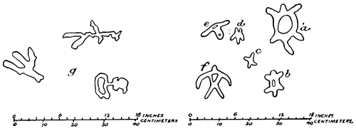
Fig. 79.—Petroglyphs in Roberts county, South Dakota.
This bowlder, 4 miles northwest of Browns valley, Minnesota, is in Roberts county, South Dakota.
The figures here represented are roughly pecked into the stone, and were never finished; for the grooves that form the pictograph on other bowlders in this region have been rubbed until they are perfectly smooth. The face of the bowlder upon which these occur is about 2 feet long and 1½ feet in width.
TENNESSEE.
Mr. John Haywood (a) gives the following account:
About 2 miles below the road which crosses the Harpeth river from Nashville to Charlotte is a large mound 30 or 40 feet high. About 6 miles from it is a large rock, on the side of the river, with a perpendicular face of 70 or 80 feet altitude. On it, below the top some distance and on the side, are painted the sun and moon in yellow colors, which have not faded since the white people first knew it. The figure of the sun is 6 feet in diameter; that of the moon is of the old moon. The sun and moon are also painted on a high rock on the side of the Cumberland river, in a spot which several ladders placed upon each other could not reach, and which is also inaccessible except by ropes let down the summit of the rock to the place where the painting was performed. * * * The sun is also painted on a high rock on the side of the Cumberland river, 6 or 7 miles below Clarksville; and it is said to be painted also at the junction of the Holston and French Broad rivers, above Knoxville, in East Tennessee; also on Duck river, below the bend called the Devil’s Elbow, on the west side of the river, on a bluff; and on a perpendicular flat rock facing the river, 20 feet below the top of the bluff and 60 above the water, out of which the rock rises, is the painted representation of the sun in red and yellow colors, 6 feet in circumference, yellow on the upper side and a yellowish red on the lower. The colors are very fresh and unfaded. The rays, both yellow and red, are represented as darting from the center. It has been spoken of ever since the river was navigated and has been there from time immemorial. * * *
The painting on Big Harpeth, before spoken of, is more than 80 feet from the water and 30 or 40 below the summit. All these paintings are in unfading colors, and on parts of the rock inaccessible to animals of every description except the fowls of the air. The painting is neatly executed, and was performed at an immense hazard of the operator.
Mr. W. M. Clarke, in Smithsonian Report for 1877, page 275, says:
On the bluffs of the Big Harpeth many pictures of Indians, deer, buffalo, and bows and arrows are to be seen. These pictures are rudely drawn, but the coloring is as perfect now as when first put on.
Haywood (b) says:
At a gap of the mountains and near the head of Brasstown creek, which is toward the head of the Hiawassee, and among the highlands, is a large horizontal rock on which are engraved the tracks of deer, bears, horses, wolves, turkeys, and barefooted human beings of all sizes. Some of the horses’ tracks appear to have slipped forward. The direction of them is westward. Near them are signs of graves.
He also (c) gives the following account:
On the south bank of the Holston, 5 miles above the mouth of French Broad, is a bluff of limestone opposite the mounds and a cave in it. The bluff is 100 feet in height. On it are painted in red colors, like those on the Paint rock, the sun and moon, a man, birds, fishes, etc. The paintings have in part faded within a few years. Tradition says these paintings were made by the Cherokees, who were accustomed in their journeys to rest at this place. Wherever on the rivers of Tennessee are perpendicular bluffs, on the sides, and especially if caves be near, are often found mounds near them, inclosed in intrenchments, with the sun and moon painted on the rocks, and charcoal and ashes in the smaller mounds. These tokens seem to be evincive of a connection between the mounds, the charcoal and ashes, the paintings and the caves.
TEXAS.
Mr. J. R. Bartlett (b) gives the following account:
About 30 miles from El Paso del Norte, in Texas, very near the boundary line of Mexico, there is an overhanging rock, extending for some distance, the whole surface of which is covered with rude paintings and sculptures, representing men, animals, birds, snakes, and fantastic figures. The colors used are black, red, white, and a brownish yellow. The sculptures are mere peckings with a sharp instrument just below the surface of the rock. The accompanying engravings [reproduced in Fig. 80] show the character of the figures and the taste of the designers. Hundreds of similar ones are painted on the rocks at this place. Some of them, evidently of great age, had been partly defaced to make room for more recent devices.
The overhanging rock, beneath which we encamped, seemed to have been a favorite place of resort for the Indians, as it is at the present day for all passing travelers. The recess formed by this rock is about 15 feet in length by 10 in width. Its entire surface is covered with paintings, one laid on over the other, so that it is difficult to make out those which belong to the aborigines. I copied a portion of these figures, about which there can be no doubt as to the origin. They represent Indians with shields and bows, painted with a brownish earth; horses, with their riders; uncouth looking animals, and a large rattlesnake. Similar devices cover the rock in every part, but are much defaced. Near this overhanging rock is the largest and finest tank or pool of water to be found about here. It is only reached by clambering on the hands and knees 15 or 20 feet up a steep rock. Over it projects a gigantic bowlder, which, resting on or wedged between other rocks, leaves a space of about 4 feet above the surface of the water. On the underside of this bowlder are fantastic designs in red paint, which could only have been made by persons lying on their backs in this cool and sheltered spot.
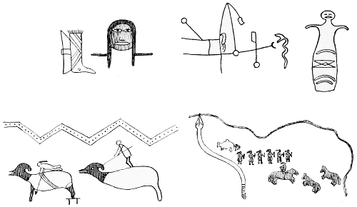
Fig. 80.—Petroglyphs near El Paso, Texas.
Mr. Charles Hallock, of Washington, District of Columbia, gives information that there is a locality termed the Painted caves, “on the Rio Grande, near Devil’s river, in Crockett county, Texas, on the line of the ‘Sunset’ railroad. Here the rock is gray limestone and the petroglyphs are for the most part sculptured. They are in great variety, from a manifest antiquity to the most recent date; for these cliff caverns have been from time immemorial the refuge and resort of all sorts of wayfarers, marauders, and adventurers, who have painted, cut, and carved in every geometrical and grotesque form imaginable.”
UTAH.
Carvings and paintings on rocks are found in such numbers in the southern interior of Utah that a locality there has been named Pictograph rocks.
Mr. G. K. Gilbert, of the U. S. Geological Survey, collected in 1875 a number of copies of inscriptions in Temple creek canyon, southeastern Utah, and noted their finding as follows:
The drawings were found only on the northeast wall of the canyon, where it cuts the Vermillion cliff sandstone. The chief parts are etched, apparently by pounding with a sharp point. The outline of a figure is usually more deeply cut than the body. Other marks are produced by rubbing or scraping, and still others by laying on colors. Some, not all, of the colors are accompanied by a rubbed appearance, as though the material had been a dry chalk.
I could discover no tools at the foot of the wall, only fragments of pottery, flints, and a metate.
Several fallen blocks of sandstone have rubbed depressions that may have been ground out in the sharpening of tools. There have been many dates of inscriptions, and each new generation has unscrupulously run its lines over the pictures already made. Upon the best protected surfaces, as well as the most exposed, there are drawings dimmed beyond restoration and others distinct. The period during which the work accumulated was longer by far than the time which has passed since the last. Some fallen blocks cover etchings on the wall, and are themselves etched.
Colors are preserved only where there is almost complete shelter from rain. In two places the holes worn in the rock by swaying branches impinge on etchings, but the trees themselves have disappeared. Some etchings are left high and dry by a diminishing talus (15 to 20 feet), but I saw none partly buried by an increasing talus (except in the case of the fallen block already mentioned).
The painted circles are exceedingly accurate, and it seems incredible that they were made without the use of a radius.
In the collection contributed by Mr. Gilbert there are at least fifteen series or groups of figures, most of which consist of the human form (from the simplest to the most complex style of drawing), animals, either singly or in long files—as if driven—bird tracks, human feet and hands, etc. There are also circles, parallel lines, and waving or undulating lines, spots, and other characters.
Mr. Gilbert also reports the discovery, in 1883, of a great number of pictographs, chiefly in color, though some are only incised, in a canyon of the Book cliff containing Thompson’s spring, about 4 miles north of Thompson’s station, on the Denver and Colorado Railroad, Utah. He has also furnished a collection of drawings of pictographs at Black rock spring, on Beaver creek, north of Milford, Utah. A number of fallen blocks of basalt at a low escarpment are filled with etchings upon the vertical faces. The characters generally are of an “unintelligible” nature, though the human figure is drawn in complex forms. Footprints and circles abound.
Mr. I. C. Russell, of the U. S. Geological Survey, furnished rude drawings of pictographs at Black rock spring, Utah (see Fig. 1093). Mr. Gilbert Thompson also discovered pictographs at Fool creek canyon, Utah (see Fig. 1094).
Mr. Vernon Bailey, in a letter dated January 18, 1889, reports that in the vicinity of St. George “all along the sandstone cliffs are strange figures like hieroglyphics and pictures of animals cut in the rocks, but now often worn dim.”
Mr. George Pope, of Provo city, Utah county, in a letter, kindly gives an account of an inscription on a rock in a canyon at the mouth of Provo river, about 7 miles from the city named. There is no paint seen, the inscription being cut. A human hand is conspicuous, being cut (probably pecked) to a depth of at least one-third of an inch, and so with representations of animals.
Dr. Rau (c) gives the design of a portion of a group carved on a cliff in the San Pete valley at the city of Manti, Utah, now reproduced as Fig. 81. He says:
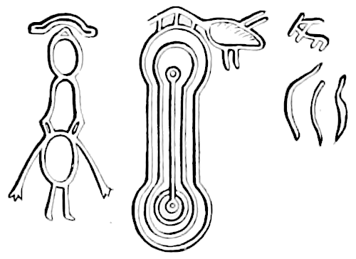
Fig. 81.—Petroglyphs near Manti, Utah.
A line drawn horizontally through the middle of the parallel lines connecting the concentric circles would divide the figure into two halves, each bearing a close resemblance to Prof. Simpson’s fifth type of cup stones. A copy of the group in question was made and published by Lieut. J. W. Gunnison, in The Mormons or Latter-Day Saints, etc., Philadelphia, 1853, p. 63. The illustration is taken from Bancroft’s Native Races (Vol. IV, p. 717). In accordance with Lieut. Gunnison’s design, the position of the grotesque human figure is changed to the left of the concentric circle. He also says that the Mormon leaders made this aboriginal inscription subservient to their religion by giving the following translation of it: “I, Mahanti, the second king of the Lamanites, in five valleys of the mountains, make this record in the twelve hundredth year since we came out of Jerusalem. And I have three sons gone to the south country to live by hunting antelope and deer.” * * * Schoolcraft attempts (Vol. III, p. 494) something like an interpretation which appears to me fanciful and unsatisfactory.
The following extract is made from The Shinumos by F. S. Dellenbaugh (a).
Some of the least disintegrated ruins are situated on the Colorado river, only a short distance below the mouth of the Dirty Devil river. * * * A level shelf varying from about 6 to 10 feet in width ran along for 150 feet or more. In most places the rocks above protruded as far as the edge of the lower rocks, sometimes farther, thus leaving a sort of gallery, generally 7 or 8 feet high. Walls that extended to the roof had been built along the outer edge of the natural floor, and the inclosed space being subdivided by stone partitions to suit the convenience of the builders, the whole formed a series of rather comfortable rooms or houses. The back walls of the houses—the natural rock—had on them many groups of hieroglyphics, and farther along where there was no roof rock at all the vertical faces had been inscribed with seeming great care. Some of the sheltered groups were painted in various dull colors, but most of them were chiseled.
The figure [82] gives a chiseled group. It is easy to see that these are signs of no low order. Considering their great age, their exposure, many of the delicate touches must be obliterated.
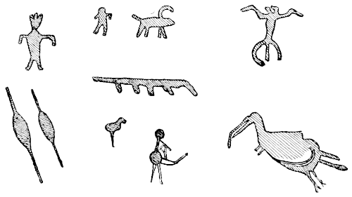
Fig. 82.—Petroglyphs on Colorado river, Utah.
The inscriptions on this ruin might possibly be the history of the defense of the crossing, the stationing of the garrison, the death of officers of rank, etc.
The following sketches of petroglyphs, with the references attached, are taken from the sketch book of Mr. F. S. Dellenbaugh, before referred to.
The petroglyph, of which Fig. 83 is a copy, appears on a horizontal rock 5 miles below the mouth of the Dirty Devil river, Utah.
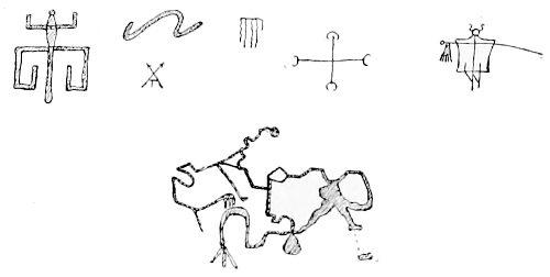
Fig. 83.—Petroglyphs on Colorado river, Utah.
The characters in Fig. 84 from rocks near the preceding group are painted red, with the imprint of a hand (on the larger figure) in white.
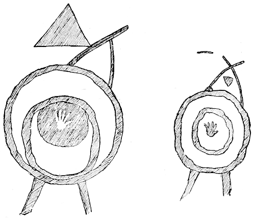
Fig. 84.—Petroglyphs on Colorado river, Utah.
The petroglyphs reproduced in Fig. 85 are copied from the vertical walls near the two groups immediately before mentioned.
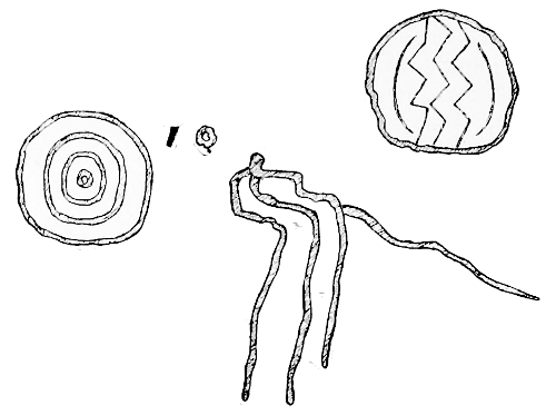
Fig. 85.—Petroglyphs on Colorado river, Utah.
The characters presented in Fig. 86 are copied from a vertical surface 10 by 16 feet in area and halfway up the ascent to the geodetic point west of “Windsor castle,” Pipe Spring. The human forms are similar in general design to the greater number of such representations made by the Shinumo Indians.
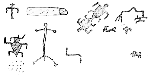
Fig. 86.—Petroglyphs at Pipe Spring, Utah.
The human forms represented in Fig. 87 are from the vicinity of Colorado river, 5 miles below the mouth of the Dirty Devil river. Mr. Dellenbaugh notes that the darkest portions of the figures indicate a chiseled surface.
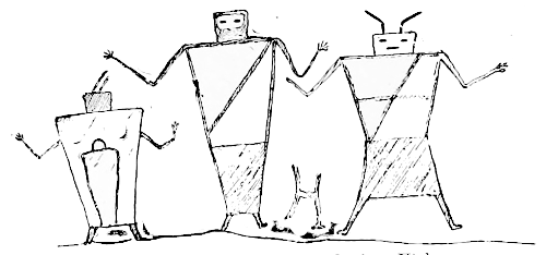
Fig. 87.—Petroglyphs on Colorado river, Utah.
Fig. 88 represents a number of petroglyphs obtained at the same locality as the one last mentioned. The greater number of the characters appear to represent snakes.
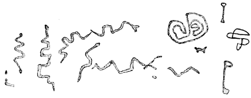
Fig. 88.—Petroglyphs on Colorado river, Utah.
Fig. 89 shows characters from the Shinumo canyon, which, according to the draftsman’s general notes, are painted.
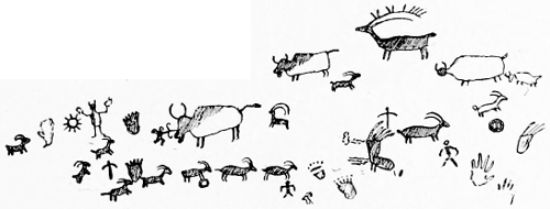
Fig. 89.—Petroglyphs in Shinumo canyon, Utah.
VIRGINIA.
In 1886 Dr. Hoffman visited a local field 9 miles southwest of Tazewell, Tazewell county, Virginia, which can be designated as follows: The range of hills bounding the western side of the valley presents at various points low cliffs and exposures of Silurian sandstone. About 4 miles below the village, known as Knob post-office, there is a narrow ravine leading up toward a depression in the range, forming a pass to the valley beyond, near the summit of which is a large irregular exposure of rock facing west-southwest, upon the eastern extremity of which are a number of pictographs, many of which are still in good preservation. Fig. 90 is a representation. The westernmost object, i. e., the one on the extreme left, appears to be a circle about 16 inches in diameter, from the outer side of which are short radiating lines giving the whole the appearance of a sun. Beneath and to the right of this is the outline of an animal resembling a doe.
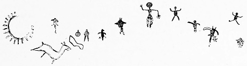
Fig. 90.—Petroglyphs in Tazewell county, Virginia.
Other figures, chiefly human, follow in close succession to the eastern edge of the vertical face of the rock, nearly all of which present the arms in various attitudes, i. e., extended or raised as in extreme surprise or adoration. Concentric rings appear at one point, while a thunder-bird is shown not far away. About 12 feet east of this place are several figures resembling the thunder-bird.
All of the characters, with one exception, are drawn in heavy or solid lines of dark red paint, presumably a ferruginous coloring material prepared in the neighborhood, which abounds in iron compounds. The exception is one object which appears to have been black, but is now so faded or eroded as to seem dark gray.
The following account of the Tazewell county, Virginia, pictographs is taken from Coale’s Life, etc., of Waters: (a)
In August, 1871, the writer went to visit Tazewell county by way of the saltworks. Upon this place are found those strangely painted rocks which have been a wonder and a mystery to all who have seen them. The grandfather of Gen. Bowen settled the cove in 1766, one hundred and ten years ago, and the paintings were there then, and as brilliant to-day as they were when first seen by a white man. They consist of horses, elk, deer, wolves, bows and arrows, eagles, Indians, and various other devices. The mountain upon which these rocks are based is about 1,000 feet high, and they lie in a horizontal line about halfway up and are perhaps 75 feet broad upon their perpendicular face.
When it is remembered that the rock is hard, with a smooth white surface, incapable of absorbing paint, it is a mystery how the coloring has remained undimmed under the peltings of the elements for how much longer than a hundred years no one can tell. This paint is found near the rocks, and Gen. Bowen informed the writers that his grandmother used it for dyeing linsey, and it was a fadeless color.
As there was a battle fought on a neighboring mountain, between 1740 and 1750, between the Cherokees and Shawnees for the possession of a buffalo lick, the remains of the rude fortifications being still visible, it is supposed the paintings were hieroglyphics conveying such intelligence to the red man as we now communicate to each other through newspapers.
It was a perilous adventure to stand upon a narrow, inclined ledge without a shrub or a root to hold to, with from 50 to 75 feet of sheer perpendicular descent below to a bed of jagged bowlders and the home of innumerable rattlesnakes, but I didn’t make it. I crawled far enough along that narrow slanting ledge with my fingers inserted in the crevices of the rocks to see most of the paintings, and then “coon’d” it back with equal care and caution.
Five miles east of the last-noted locality and 7 west of Tazewell, high up against a vertical cliff of rock, is visible a lozenge-shaped group of red and black squares, known in the locality as the “Handkerchief rock,” because the general appearance of the colored markings suggests the idea of an immense bandana handkerchief spread out. The pictograph is on the same range of hills as the preceding, but neither is visible from any place near the other. The objects can not be viewed upon Handkerchief rock excepting from a point opposite to it and across the valley, as the locality is so overgrown with large trees as to obscure it from any position immediately beneath. The lozenge or diamond-shaped figure appears to cover an area about 3 feet in diameter.
WASHINGTON.
Capt. Charles Bendire, U. S. Army, in a letter dated Fort Walla-walla, Washington, May 18, 1881, mentions a discovery made by Col. Henry C. Merriam, then lieutenant-colonel Second United States Infantry, as thus quoted:
While encamped at the lower end of Lake Chelan, lat. 48° N., he made a trip to the upper end of said lake, where he found a perpendicular cliff of granite with a perfectly smooth surface, from 600 to 1,000 feet high, rising out of the lake. On the cliff he found Indian picture-writings, painted evidently at widely different periods, but evidently quite old. The oldest was from 25 to 30 feet above the present water level, and could at the time they were executed only be reached by canoe. The paintings are figures, black and red in color, and represent Indians with bows and arrows, elk, deer, bear, beaver, and fish, and are from 1 foot to 18 inches in size. There are either four or five rows of these figures, quite a number in each row. The Indians inhabiting this region know nothing of the origin of these pictures, and say that none of their people for the past four generations knew anything about them.
Since the preceding letter was written a notice of the same rock has been published, together with an illustration, by Mr. Alfred Downing, of Seattle, Washington, in “The Northwest,” VII, No. 10, October, 1889, pp. 3, 4. The description, condensed, is as follows:
In that part of Washington territory until recent years known as the Moses Indian reservation lies the famous Lake Chelan, 70 miles in length with an average width of 2 miles.
About half a mile from its head, on the western shore and rising from the water, as an abrupt and precipitous wall of granite, stands “Pictured rock.”
The most remarkable feature of the Chelan picture is that the figures representing Indians, bear, deer, birds, etc., are painted upon the surface of the smooth granite, nearly horizontal, but about 17 feet above the lake; the upper portion of the picture being about 2 feet higher. The figures depicted are 5 to 10 inches long.
The difference between high and low stage of water at any period during the year does not exceed 4 feet, and this high-water mark being well defined along the shore, it becomes self-evident that these signs were placed there ages ago, when the water was 17 feet higher than it is now. The granite bluff or walls in this instance are smooth, being weather and water worn, and afford no hold for hand or foot either from above or below, and from careful observation it would appear to be a physical impossibility for either a white or red man to show his artistic skill on those rocks unless at the ancient stage of water and with the aid of a canoe or a “dugout.”
The paint or color used was black and red, the latter resembling venetian. How wonderfully the color has stood the test in the face of the storms to which the lake is subject is apparent; only in one or two instances does it to-day show any signs of fading or weather-wearing. The signs impressed me as intending to convey the idea of the prowess of an Indian chief in the hunt, or as being a page in the history of a tribe, the small perpendicular strokes seen in the lower portion indicating probably the number of bear, deer, or other animals slain.
When referring, in Pacific Railroad Report, vol. I, page 411, to a locality on the Columbia river in Washington, between Yakima and Pisquouse counties, Mr. George Gibbs mentioned pecked and colored petroglyphs which he found there as follows:
It was a perpendicular rock, on the face of which were carved sundry figures, most of them intended for men. They were slightly sunk into the sandstone and colored, some black, others red, and traces of paint remained more or less distinctly on all of them. These also, according to their [the Indians’] report, were the work of the ancient race; but from the soft nature of the rock, and the freshness of some of the paint, they were probably not of extreme antiquity.
For another example of petroglyphs from Washington see Fig. 679.
WEST VIRGINIA.
Mr. John Haywood (d) gives the following account:
In the county of Kenhaway [Kanawha] about 4 miles below the Burning spring, and near the mouth of Campbell’s creek, in the state of Virginia, is a rock of great size, on which, in ancient times, the natives engraved many representations. There is the figure of almost every indigenous animal—the buffalo, the bear, the deer, the fox, the hare, and other quadrupeds of various kinds; fish of the various productions of the western waters, fowls of different descriptions, infants scalped, scalps alone, and men as large as life. The rock is in the river Kenhaway, near its northern shore, accessible only at low water unless by the aid of water craft.
The following notice of the same locality, but perhaps not of the same rock, was published by James Madison (a), bishop of Virginia, in 1804:
I cannot conclude this letter without mentioning another curious specimen of Indian labour, and of their progress in one of the arts. This specimen is found within 4 miles of the place whose latitude I endeavoured to take, and within 2 of what are improperly called Burning springs, upon a rock of hard freestone, which sloping to the south, touching the margin of the river, presents a flat surface of above 12 feet in length and 9 in breadth, with a plane side to the east of 8 or 9 feet in thickness.
Upon the upper surface of this rock, and also upon the side, we see the outlines of several figures, cut without relief, except in one instance, and somewhat larger than the life. The depth of the outline may be half an inch; its width three-quarters, nearly, in some places. In one line ascending from the part of the rock nearest the river there is a tortoise; a spread eagle, executed with great expression, particularly the head, to which is given a shallow relief, and a child, the outline of which is very well drawn. In a parallel line there are other figures, but among them that of a woman only can be traced. These are very indistinct. Upon the side of the rock there are two awkward figures which particularly caught my attention. One is that of a man with his arms uplifted, and hands spread out as if engaged in prayer. His head is made to terminate in a point, or rather, he has the appearance of something upon the head of a triangular or conical form; near to him is another similar figure suspended by a cord fastened to his heels. I recollected the story which Father Hennepin relates of one of the missionaries from Canada who was treated in a somewhat similar manner, but whether this piece of seemingly historical sculpture has reference to such an event can be only a matter of conjecture. A turkey, badly executed, with a few other figures may also be seen. The labour and the perseverance requisite to cut those rude figures in a rock so hard that steel appeared to make but little impression upon it, must have been great; much more so than making of enclosures in a loose and fertile soil.
Another petroglyph, a copy of which is presented in Fig. 1088, is thus described in a letter from Morgantown, West Virginia:
The famous pictured rocks on the Evansville pike, about 4 miles from this place, have been a source of wonder and speculation for more than a century, and have attracted much attention among the learned men of this country and Europe. The cliff upon which these drawings exist is of considerable size and within a short distance of the highway above mentioned. The rock is a white sandstone, which wears little from exposure to the weather, and upon its smooth surface are delineated the outlines of at least fifty [?] species of animals, birds, reptiles, and fish, embracing in the number panthers, deer, buffalo, otters, beavers, wildcats, foxes, wolves, raccoons, opossums, bears, elk, crows, eagles, turkeys, eels, various sorts of fish, large and small, snakes, etc. In the midst of this silent menagerie of specimens of the animal kingdom is the full length outline of a female form, beautiful and perfect in every respect. Interspersed among the drawings of animals, etc., are imitations of the footprints of each sort, the whole space occupied being 150 feet long by 50 feet wide. To what race the artist belonged or what his purpose was in making these rude portraits must ever remain a mystery, but the work was evidently done ages ago.
The late P. W. Norris, of the Bureau of Ethnology, reported that he found petroglyphs in many localities along the Kanawha river, West Virginia. Engravings are numerous upon smooth rocks, covered during high water, at the prominent fords in the river, as well as in the niches or long shallow caves high in the rocky cliffs of this region. Rude representations of men, animals, and some characters deemed symbolic were found, but none were observed superior to, or essentially differing from those of modern Indians.
On the rocky walls of Little Coal river, near the mouth of Big Horse creek, are cliffs which display many carvings. One of the rocks upon which a mass of characters appear, is 8 feet in length and 5 feet in height.
About 2 miles above Mount Pleasant, Mason county, on the north side of the Kanawha river, are numbers of characters, apparently totemic. These are at the foot of the hills flanking the river.
On the cliffs near the mouth of the Kanawha river, opposite Mount Carbon, Nicholas county, are numerous pictographs. These appear to be cut into the sandstone rock.
Pictographs were lately seen at various points on the banks of the Kanawha river, both above and below Charleston, but since the construction of the Chesapeake and Ohio railroad some of the rocks bearing them have been destroyed. About 6 miles above Charleston there was formerly a rock lying near its water’s edge upon which, it is reported by old residents, were depicted the outline of a bear, turkey tracks, and other markings. Tradition told that this was a boat or canoe landing, used by the Indians in their travels when proceeding southward. The tribe was not designated. From an examination of the locality it was learned that this rock had been broken and used in the construction of buildings. It is said that a trail passing there led southward, and at a point 10 miles below the Kanawha river stood several large trees upon which were marks of red ocher or some similar pigment, at which point the trail spread or branched out in two directions, one leading southward into Virginia, the other southwest toward Kentucky.
On a low escarpment of sandstone facing Little Coal river, 6 or 8 miles above its confluence with Coal river and about 18 miles south of the Kanawha river, are depicted the outlines of animals, such as the deer, panther (?), etc., and circles, delineated in dark red, but rather faint from disintegration of the surface. The characters are similar in general appearance to those in Tazewell county, Virginia, and appear as if they might have been made by the same tribe. There are no peculiarities in the topography of the surrounding region that would suggest the idea of their having served as topographic indications, but they rather appear to be a record of a hunting party, and to designate the kinds of game abounding in the region.
Mr. L. V. McWhorter reports pictographs in a cave near Berlin, Lewis county, West Virginia. No details are given.
A petroglyph found in a rock shelter in West Virginia is also presented in Pl. XXXI.
WISCONSIN.
A large number of glyphs are incised on the face of a rock near Odanah, now a village of the Ojibwa Indians, 12 miles northeast from Ashland, on the south shore of lake Superior, near its western extremity. The characters were easily cut on the soft stone, so were also easily worn by the weather, and in 1887 were nearly indistinguishable. Many of them appeared to be figures of birds. An old Ojibwa Indian in the vicinity told the present writer that the site of the rock was formerly a well-known halting place and rendezvous, and that on the arrival of a party, or even of a single individual, the appropriate totemic mark or marks were cut on the rock, much as white men register their names at a hotel.
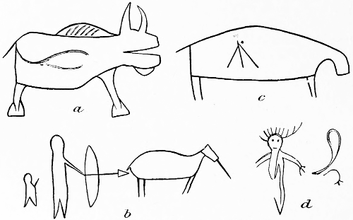
Fig. 91.—Petroglyphs in Brown’s cave, Wisconsin.
The Pictured cave of La Crosse valley, called Brown’s cave, is described by Rev. Edward Brown (a) as follows:
This curious cavern is situated in the town of Barre, 4 miles from West Salem and 8 miles from La Crosse. * * *
Before the landslide it was an open shelter cavern, 15 feet wide at the opening and 7 feet at the back end; greatest width, 16 feet; average, 13; length, 30 feet; height, 13 feet, and depth of excavation after clearing out the sand of the landslide, 5 feet. The pictures are mostly of the rudest kind, but differing in degree of skill. Except several bisons, a lynx, rabbit, otter, badger, elk, and heron, it is perhaps impossible to determine with certainty what were intended or whether they represented large or small animals, no regard being had to their relative sizes.
[Examples of the figures are here presented as Fig. 91.]
Perhaps a indicates a bison or buffalo, and is the best executed picture of the collection. Its size is 19 inches long by 15½ inches from tip of the horns to the feet.