Chapter IX · (continued 3)
Reading edition
The territorial disputes of Connecticut and New Haven with the Dutch at Manhados, which began early and were of long continuance, find abundant illustration in Trumbull’s History of Connecticut, and in Brodhead’s History of New York, and in the documentary history, of which the materials were procured by Brodhead, but arranged by O’Callaghan.[666]
The records of the two colonies show the ample provision made for public schools, and indicate a project entertained by New Haven as early as 1648 to found a college,—a scheme not consummated, however, till a later period.
The Winthrop charter of 1662, which united the two colonies, is in Hazard, ii. 597, taken from a printed volume of Charters, London, 1766. It had been printed at New London in 1750, in a volume of Acts and Laws, and is in a volume by Samuel Lucas, London, 1850. The charter bears date April 23, 1662. In an almanac of John Winthrop, the younger, for the year 1662, once temporarily in my possession, and now belonging to the Hon. Robert C. Winthrop, I noticed this manuscript note of the former owner, which I copied: “This day, May 10, in the afternoon, the Patent for Connecticut was sealed.” The orders, instructions, and correspondence relating to the procuring of this charter are printed in the Colonial Records, text and Appendix, and in Trumbull, vol. i., text and Appendix.[667]
The Restoration brought its anxieties as well as its blessings. The story of the shelter afforded to the regicides Whalley and Goffe, by New Haven, is an interesting episode. Dr. Stiles’s volume, A History of the Three Judges [including Colonel Dixwell] of King Charles I., etc. (Hartford, 1794), is a minute collection of facts, though not always carefully weighed and analyzed.[668]
The granting of the royal charter of 1662, which was followed next year by that to Rhode Island, brought on the long controversy with that colony as to the eastern boundary of Connecticut; and the revival of the claim of the heirs of the Duke of Hamilton—a claim more easily disposed of—added to the annoyances. The papers relating to these controversies may be seen in the Colonial Records of Connecticut, ii. 526-554, and of Rhode Island, ii. 70-75, 128.[669]
After the union, the earliest printed Book of General Laws for the People within the Jurisdiction of Connecticut was in 1673,—the code established the year before. It was printed at Cambridge.[670]
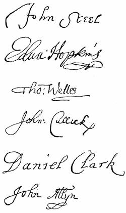
COLONIAL SECRETARIES.
[These secretaries held office consecutively: Steele, 1636-39; Hopkins, 1639-40; Wells, 1640-48; Cullick, 1648-58; Clark, 1658-63; Allyn, 1663-65.—Ed.]
The authorities for the history of Philip’s War—so disastrous to Massachusetts, Plymouth, and Rhode Island, but from which “Connecticut,” says Trumbull, “had suffered nothing in comparison with her sister colonies”—have already been given under the head of “Massachusetts.” Without citing special documents, it may be said that Trumbull’s History of Connecticut and Palfrey’s New England furnish abundant authority from this time down to the conclusion of the government of New England under Andros, and the narrative of each may be referred to as fitting, ample, and trustworthy. Trumbull’s History, as an original authority, may well compare for Connecticut with Hutchinson’s History for Massachusetts. The first volume (1630-1713) was published in 1797; and, although the titlepage to it reads “Vol. I.,” the author says in the Preface to vol. ii., first printed in 1818 (1713-1764), that he never had any design of publishing another volume. The first volume was reprinted in 1818 as a companion to vol. ii.[671]
The Records of Connecticut for the period embraced in this chapter are abundant, and are admirably edited, with explanatory notes, by Dr. J. Hammond Trumbull, of Hartford, who has done so much to illustrate the history of his State, and indeed of New England.[672] I might add that Dr. Palfrey, in writing the History of New England, often had the benefit of Dr. Trumbull’s learning in illustrating many obscure points in Connecticut history.[673]
The New Haven Colony Records end, of course, with the absorption of that colony by Connecticut. These are well edited, in two volumes (1638 to 1649, and 1653 to 1665), with abundant illustrations in the Appendix, by Charles J. Hoadly, M.A., and were published at Hartford in 1857-58.
The Collections of the Connecticut Historical Society have already been referred to.[674]
The New Haven Colony Historical Society is a separate body, devoted to preserving the memorials of that colony. It has issued three volumes of Papers.[675]
Among the general histories of Connecticut was one by Theodore Dwight, Jr., in Harper’s Family Library, 1840; also another by G. H. Hollister, 2 vols., 1855, and enlarged in 1857. A condensed History of the Colony of New Haven, before and after the Union, by E. R. Lambert, was published at New Haven in 1838; and a more extensive History of the Colony of New Haven to its Absorption into Connecticut, by E. E. Atwater, was published in New Haven in 1881.[676] There are some town histories which, for the early period, have almost the character of histories of the State,—like Caulkins’s Norwich (originally 1845; enlarged 1866, and again in 1874) and New London (1852); Orcutt and Beadsley’s Derby (1642-1880); William Cothren’s Ancient Woodbury, 3 vols., published in 1854-79; H. R. Stiles’s Ancient Windsor, 2 vols., 1859-63. Barber’s Connecticut Historical Collections is a convenient manual for ready reference.[677]
Rhode Island.[678]—The first published history of the colony of Rhode Island and Providence Plantations was an Historical Discourse, delivered at Newport in 1738, on the centennial of the settlement of Aquedneck, by John Callender, minister of that place, and printed at Boston the next year.[679]
Twenty-seven years afterward,—that is, in 1765,—there appeared in seven numbers of a newspaper (the Providence Gazette), from January 12 to March 30, “An Historical Account of the Planting and Growth of Providence.” This sketch, written by the venerable Stephen Hopkins, then governor of the State, interrupted by the disastrous occurrences of the times, comes down only to 1645, and remains a fragment.[680]
A Gazeteer of the States of Connecticut and Rhode Island, with maps of each State, was published at Hartford in 1819, in 8º, compiled by John C. Pease and John M. Niles. It furnished for the time a large amount of statistical and historical material. The work gives a geographical sketch of each county, with details of each town, and “embraces notices of population, business, etc., together with biographical sketches of eminent men.”
“Memoirs of Rhode Island” were written by the late Henry Bull, of Newport, in 1832, and published in the Rhode Island Republican (newspaper) of that year.[681] A Discourse embracing the Civil and Religious History of Rhode Island, delivered at Newport, April 4, 1838, by Arthur A. Ross, pastor of a Baptist church at Newport, was published at Providence in the same year, and is full on the history of Newport.
In 1853 there was published in New York an octavo volume of 370 pages, entitled History of Rhode Island, by the Rev. Edward Peterson. “This book abounds in errors, and is of no historical value. It is not a continuous history, but is made up of scraps, without chronological arrangement.”[682]
In 1859 and 1860 was published the History of the State of Rhode Island and Providence Plantations, by Samuel Greene Arnold, in two volumes,[683]—a work honorable alike to its author and to the State. While Mr. Arnold was writing this history, Dr. Palfrey was engaged upon his masterly History of New England. These writers differed somewhat in their interpretation of historical events and in their estimate of historical personages, and the student of New England history should read them both. The value of these works consists not only in the text or narrative parts, but also in the notes, which for the student, particularly in Dr. Palfrey’s book, contain valuable information, in a small compass, upon the authorities on which the narrative rests.
The late George Washington Greene prepared A Short History of Rhode Island, published in 1877, in 348 pages, which formed an excellent compendium, much needed. It is compiled largely from Mr. Arnold’s work.
“The Early History of Narragansett,” by Elisha R. Potter, was published as vol. iii. of the R. I. Hist. Soc. Coll., in 1835. It is a valuable collection of events, arranged in chronological order, and illustrated by original documents in an appendix.
“The Annals of the Town of Providence from its First Settlement,” etc., to the year 1832, by William R. Staples, was published, in 1834, as vol. v. of the R. I. Hist. Soc. Coll. The author says that the work does not assume to be a “history;” but it is a valuable and authentic record of events from the time of Roger Williams’s settlement on the banks of the Mooshausic, in 1636, to the year 1832, illustrated by original documents, the whole making 670 pages.
I ought not to omit the mention of several addresses and discourses delivered before the Rhode Island Historical Society, some of which have considerable historical interest, as illustrating the principles on which it is claimed that Rhode Island was founded. Special mention may be made of the Discourse of Judge Pitman, that of Chief Justice Durfee, and that of the late Zachariah Allen.[684]
As Roger Williams is properly held to be the founder of the State of Rhode Island; and as many of his writings had become quite rare, a society was formed in 1865, called the “Narragansett Club,” for the purpose of republishing all his known writings. Vol. i., containing Williams’s Key to the Indian Languages of America, edited by Dr. J. Hammond Trumbull,[685] was issued in 1866; and vol. vi., the concluding volume, in which are collected all the known letters of Williams, in 1874. The volumes were published in quarto form, in antique style, and edited by well-known historical scholars, and are a valuable contribution to the personal history of Roger Williams and to the history of the controversy on religious liberty, of which he was the great advocate.[686]
The earliest publication of any of Williams’s letters was by Isaac Backus, in his History of New England, etc., 1777, 1784, 1796, in three volumes, written with particular reference to the Baptists. It treats largely of Rhode Island history, and is a most authentic work.[687]
A series of Rhode Island Historical Tracts, beginning in 1878, has been issued by Sidney S. Rider, of Providence, each being a monograph on some subject of Rhode Island history. No. 4, on William Coddington in Rhode Island Colonial Affairs, is an unfavorable criticism on the conduct of Coddington in the episode known as “the Usurpation,” by Dr. Henry E. Turner.[688] No. 15, issued in 1882, is a tract of 267 pages, on The Planting and Growth of Providence, by Henry C. Dorr. It is a valuable monograph, and would have been more valuable if authorities had been more freely cited.
One valuable source of the history of Rhode Island is the Records of the colony, and these have been made available for use by publication, under the efficient editorship of the Hon. John Russell Bartlett, for a number of years Secretary of State. To make up for the meagreness of the records in some places, the editor has introduced from exterior sources many official papers, which make good the deficiencies and abundantly illustrate the history of the times. The first volume was issued in 1856, and begins with the “Records of the Settlements at Providence, Portsmouth, Newport, and Warwick, from their commencement to their union under the Colony Charter, 1636 to 1647.”
The early history of Providence is so intimately interwoven with the life of its founder, that some of the excellent memoirs of Roger Williams may be read with profit as historical works. A Memoir of Williams, by Professor James D. Knowles, was published in 1834, and is a minute and conscientious biography of the man; but it is written with a strong bias in favor of Williams where he comes in collision with the authorities of Massachusetts.
A very pleasant memoir of Williams, by Professor William Gammell, based on that of Knowles, was published in 1845, in Sparks’s American Biography, reissued the next year in a volume by itself. This memoir was followed in 1852 by A Life of Roger Williams, by Professor Romeo Elton, published in England, where the author then lived, and in Providence the next year. This is largely based on Knowles’s memoir, but contains some new matter, notably the Sadlier Correspondence.
The original authorities for Williams’s career in Massachusetts and Plymouth are Winthrop and Bradford and the controversial tracts of Cotton and Williams, from which bits of history may be culled. For a full presentation and discussion of the facts and principles involved in Williams’s banishment from Massachusetts, and his alleged offence to the authorities there, see the late Professor Diman’s Editorial Preface to Cotton’s Reply to Williams, in the second volume of the Narragansett Club, above cited; Dr. George E. Ellis’s Lecture on “The Treatment of Intruders and Dissentients by the Founders of Massachusetts,” in Lowell Lectures, Boston, Jan. 12, 1869; Dr. Henry Martyn Dexter’s As to Roger Williams, etc., Boston, 1876;[689] Mass. Hist. Soc. Proc., for February, 1873, pp. 341-358; North American Review for January, 1858, art. xiii. p. 673.
In Dr. John Clarke’s Ill News from New England, London, 1653,[690] being a personal narrative of the treatment, the year before, by the authorities of the Bay Colony, of Obadiah Holmes, John Crandall, and John Clarke, and an account of the laws and ecclesiastical polity of that colony, is a brief account of the settlement of Providence and of the island of Rhode Island.
An important episode in the early history of Rhode Island was the career of Samuel Gorton, who settled the town of Warwick. I have already mentioned, under the head of Massachusetts, the original books in which the story for and against him is told,—Simplicitie’s Defence, written by Gorton, and Hypocracie Unmasked, by Edward Winslow. The former was republished in the R. I. Hist. Soc. Coll., vol. ii., in 1835, edited by W. R. Staples, with a preface, notes, and appendix of original papers. Winslow’s book, now very rare, has never been reprinted. A “Life of Samuel Gorton,” by John M. Mackie, was published in 1845 in Sparks’s American Biography. After Nathaniel Morton published his New England’s Memorial, in 1669, containing some reflections on Gorton, the latter wrote a letter to Morton, dated “Warwick, June 30, 1669,” in his own defence. Hutchinson had the letter, and printed an abridgment of it in the Appendix to his first volume. Some forty years ago or less, the original letter came into the possession of the late Edward A. Crowninshield, of Boston, and he allowed Peter Force to print it, and it appears entire in vol. iv. of Force’s Historical Tracts, 1846.
The early settlers of Rhode Island had no patent-claim to lands on which they planted. The consent of the natives only was obtained. Williams’s deed, so called, from the Indians, may be seen in vols. iv. and v. R. I. Hist. Soc. Coll.; and that to Coddington and his friends, of Aquedneck, is also in the Appendix to vol. iv. The parchment charter which Williams obtained from the Parliamentary Commissioners, dated March 14, 1643, is lost, but it had been copied several times, and is printed in vols. ii., iii., and iv., R. I. Hist. Soc. Coll. Some copies are dated erroneously March 17. See Arnold’s Rhode Island, i. 114, note.
For a discussion of the “Narragansett Patent,” so called, issued to Massachusetts, dated Dec. 10, 1643, see Arnold, i. 118-120; Mass. Hist. Soc. Proc. for February, 1862, pp. 401-406; and June, 1862; pp. 41-77.[691]
The original charter of Charles II., dated July 8, 1663, is extant. It was first printed as prefixed to the earliest digest of laws (Boston, 1719), and has been often reprinted.
The incorporation of Providence plantations under the charter of 1643/44 was delayed for several years, and took place in 1647, when a code of laws was adopted. This code was first printed in 1847, edited by Judge William R. Staples, in a volume entitled The Proceedings of the First General Assembly of “the Incorporation of Providence Plantations,” and the Code of Laws adopted by that Assembly in 1647, with Notes, Historical and Explanatory (64 pages). The original manuscript of these laws is in a volume of the early records in the Secretary of State’s office.
The earliest printed digest of laws, entitled Acts and Laws, was in 1719,—printed at Boston “for John Allen and Nicholas Boone.”[692] In this, the following clause appears as part of a law purporting to have been enacted in March, 1663-64: “And that all men professing Christianity, and of competent estates and of civil conversation, who acknowledge and are obedient to the civil magistrate, though of different judgments in religious affairs (Roman Catholics only excepted), shall be admitted freemen, and shall have liberty to choose and be chosen officers in the colony, both military and civil.” This same clause appears in the four following printed digests named above, and it remained a law of the colony till February, 1783, when the General Assembly formally repealed so much of it as related to Roman Catholics. Rhode Island writers consider it a serious reflection upon the character of the founders of the colony to assert that this clause was enacted at the time indicated; and one writer (Judge Eddy, in Walsh’s Appeal, 2d ed., p. 433) thinks it possible that the clause was inserted in a manuscript copy of the laws sent over to England in 1699, without, of course, being enacted into a law. The clause, it is said, does not exist in manuscript in the archives of the colony, and is not in the manuscript digest of 1708, though Mr. Arnold, History, ii. 492, inadvertently says it is there. If the clause was originally smuggled in among the statutes of Rhode Island at a later period than the date assigned to it (see R. I. Hist. Soc. Proc., 1872-73, p. 64), it was five times formally re-enacted when the several digests named above were submitted by their revising committees, and passed the General Assembly; and it remained a law till 1783.
In 1762, two persons professing the Jewish religion petitioned the Superior Court of the colony to be made citizens. Their prayer was rejected. The concluding part of the opinion of the court is as follows: “Further, by the charter granted to this colony it appears that the free and quiet enjoyment of the Christian religion and a desire of propagating the same were the principal views with which this colony was settled, and by a law made and passed in the year 1663, no person who does not profess the Christian religion can be admitted free of this colony. This Court, therefore, unanimously dismiss this petition, as wholly inconsistent with the first principles upon which the colony was founded and a law of the same now in force” (Arnold, History, ii. 492-495). Arnold says that previous to this decision several Jews and Roman Catholics had been naturalized as citizens by special acts of the General Assembly.
Has there not been a misapprehension as to the bearing of this law or clause disfranchising or refusing to admit to the franchise Roman Catholics and persons not Christians, and as to Roger Williams’s doctrine of religious liberty? The charter of Rhode Island declared that no one should be “molested ... or called in question for any differences of opinion in matters of religion.” The law in question does not relate to religious liberty, but to the franchise. Rhode Island has always granted liberty to persons of every religious opinion, but has placed a hedge about the franchise; and this clause does it. Was it not natural for the founders of Rhode Island to keep the government in the hands of its friends while working out their experiment, rather than to put it into the hands of the enemies of religious liberty? How many shiploads of Roman Catholics would it have taken to swamp the little colony in the days of its weakness? Chalmers (Annals, p. 276) copied his extract of the law in question from the digest of 1730, as per minutes formerly belonging to him in my possession. As an historian where could he seek for higher authority? Indeed, the clause had already been cited by Douglass in his Summary, ii. 83, Boston, 1751; and by the authors of the History of the British Dominions in North America, part i. p. 232, London, 1773. The latter as well as Chalmers omitted the phrase “professing Christianity.” But Chalmers was entirely wrong in his comments upon the clause where he says that “a persecution was immediately commenced against the Roman Catholics.”[693]


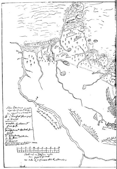
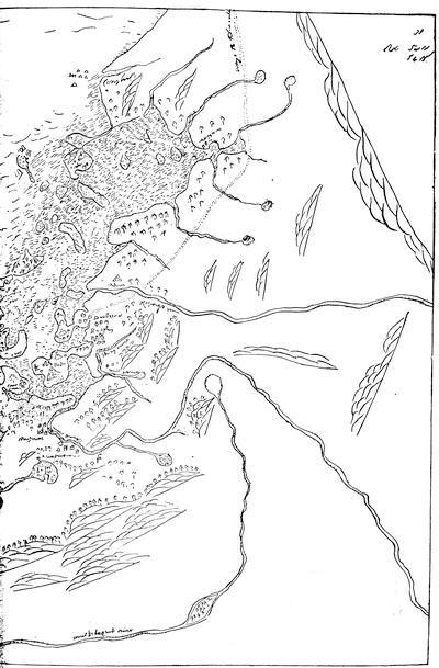
THE WINTHROP MAP (Circa 1633).
AMONG the Sloane manuscripts in the British Museum is one numbered “Add: 5,415, G. 3,” whose peculiar interest to the American antiquary escaped notice till Mr. Henry F. Waters sent photographs of it to the Public Library in Boston in 1884, when one of them was laid before the Massachusetts Historical Society by Judge Chamberlain, of that Library (Proceedings, 1884, p. 211). It was of the size of the original, somewhat obscure, and a little deficient on the line where its two parts joined. At the Editor’s request, Mr. Richard Garnett, of the British Museum, procured a negative on a single glass; and though somewhat reduced, the result, as shown in the accompanying fac-simile, is more distinct, and no part is lost.
The map is without date. The topography corresponds in the main with that of the map which William Wood added to his New England’s Prospect (London, 1634), so far as its smaller field corresponds, and suggests the common use of an earlier survey by the two map-makers,—if, indeed, Wood did not depend in part on this present survey. That its observations were the best then made would seem clear from the fact that Governor Winthrop explained it by a marginal key, and added in some places a further description to that given by the draughtsman (as a change in the handwriting would seem to show,—for instance, in the legend on the Merrimac River), if indeed all is not Winthrop’s. Who the draughtsman was is not known. There had been in the colony a man experienced in surveying,—Thomas Graves,—who laid out Charlestown, before Winthrop’s arrival; but he is not known to have remained till the period of the present survey, which, if there has been nothing added to the original draught, was seemingly made as early as that given by Wood. This last traveller left New England, Aug. 15, 1633; and his description of the plantations about Boston at that time, which he professes to make complete, is almost identical with the enumeration on this map, though he gives a few more local names. Wood’s map is dated 1634; but it seems certain that he carried it with him in August, 1633,—a date as late apparently as can be attached to the present draught.
The key added by Winthrop to the north corner of the map reads as follows:—
A: an Iland cont[aining] 100 acres, where the Gouvenr. hathe an orchard & a vineyarde. B: Mr. Humfryes ferme [farm] house at Sagus [Saugus]. Tenhills: the Gouernrs. ferme [farm] house. Meadford: Mr. Cradock ferme [farm] house. C: the Wyndmill} D: the fforte } at Boston. E: the Weere
So far as the rivers are laid thus [shaded], they are navigable wth the Tide.
[SCALE.]
Scale of 10: Italian miles 320 pches [perches] to the mile, not taken by Instrument, but by estimate.
In the north the Merrimac is shown to be navigable to a fall. The stream itself is marked Merimack river; it runnes 100 miles up into the Country, and falles out of a ponde 10 miles broad. It receives the Musketaquit riuer [Concord] just south of the scale. The long island near its mouth is Plum Island, but it is not named. The village of Agawam [Ipswich] is connected by roads [dotted lines] with Sagus [Saugus], Salem, Winesemett, and Meadford, which is called “Misticke” in Wood’s text, but “Meadford” in his map. On Cape Anne peninsula Anasquom is marked. The bay between Marblehead and Marblehead Neck is called Marble Harbour, as by Wood in his map. Nahant is marked, as are also Pulln Point, Deere I., Hogg I., Nottles I. Governor’s Island is marked A., referring to the key. Charlestown is called Char:towne. Spott Ponde flows properly through Malden River, not named, into the Mystic; and Mistick river takes the water of a number of ponds. The modern Horn Pond in Woburn is not shown. The three small ponds near a hill appear to be Wedge Pond and others in Winchester; the main water is Mistick pond, 60 fathoms deepe; horn ponde is the modern Spy Pond; Fresh Pond is called 40 fathom deepe. Their watershed is separated by the Belmont hills, not named, from the valley of the Concord. The villages of Waterton and Newtowne [Cambridge] are marked on the Charls River. The peninsula of Boston shows Beacon Hill, not named, while C and D are explained in the key. Muddy river [Muddy Brook in Brookline] and Stony river [Stony Brook in Roxbury] are correctly placed. Rocksbury and Dorchester appear as villages. Hills are shown on Dorchester Neck, or South Boston. Naponsett river is placed with tolerable correctness. The islands in Boston Harbor are all represented as wooded. The waye to Plimouth, beginning at Dorchester, crosses the Weymouth rivers above Wessaguscus [Wessagussett]. Trees and eminences are marked on Nataskette [Hull], and Cohasset is called Conyhassett. The same sign stands for rocks in the Bay and for Indian villages on the land.
It may be well further to notice that since the printing of this volume A Briefe Discription of New England, 1660, by Samuel Maverick, has likewise been discovered in the British Museum by Mr. Waters, and is printed in the Proceedings of the Massachusetts Historical Society, October, 1884, and in the New England Historical and Genealogical Register, January, 1885.—Ed.
EDITORIAL NOTES.
A. Bibliographical.—Rhode Island has been fortunate in its bibliographer. Mr. John Russell Bartlett, the editor of the State’s early Records, issued at Providence, in 1864, his Bibliography of Rhode Island, with Notes, Historical, Biographical, and Critical (150 copies printed). Mr. Bartlett began a “Naval History of Rhode Island” in the Historical Magazine, January, 1870. As the adviser of the late Mr. John Carter Brown in the forming of what is now so widely known as the Carter-Brown Library, and as the cataloguer of its almost unexampled treasures, not only of Rhode Island, but of all American history, Mr. Bartlett has also conferred upon the student of American history benefits equalled in the labors of few other scholars in this department. Mr. Brown erected for himself in his Library a splendid monument. There may exist in the Lenox Library a rival in some departments of Americana, but Mr. Bartlett’s Catalogue of the Providence Collection makes its richness better known. Mr. Brown began his collections early, and was enabled to buy from the catalogues of Rich and Ternaux. The Library is now so complete, and its desiderata are so few and so scarce, that it grows at present but slowly. Mr. Brown, a son of Nicholas Brown, from whom the university in Providence received its name, was born in 1797, and died June 10, 1874. But fifty copies of the two sumptuous volumes (1482-1700) constituting the revised edition of the catalogue (there is a third volume, 1700-1800, in a first edition) have been distributed, and they are the Library’s best history; but those not fortunate enough to have access to them will find accounts of it in the Bibliotheca Sacra, April, 1876; Rogers’s Libraries of Providence; N.E. Hist. and Geneal. Reg., April, 1876; American Journal of Education, xxvii. 237; American Bibliopolist, vi. 77, vii. 91, 228.
The several volumes of the Rhode Island Historical Society, so far as they relate to the period under examination, are noted in the preceding text; but the Society has also issued a volume of Proceedings for the years 1872-1879. Two supplemental publications of the Rhode Island antiquaries have been begun lately,—the Newport Historical Magazine, July, 1880, and the Narragansett Historical Register, July, 1882, James N. Arnold, editor, both devoted to southern Rhode Island.
B. Early Maps of New England.—The cartography of New England in the seventeenth century began with the map of Captain John Smith in 1614 (given in chap. vi.), for we must discard as of little value the earlier maps of Lescarbot and Champlain. The Dutch were on the coast at about the same time, and the best development of their work is what is known as the “Figurative Map” of 1614, which was first made known in the Documents relating to the Colonial History of New York, i. 13, and in O’Callaghan’s New Netherland. The part showing New England is figured in the Memorial History of Boston, i. 57. It had certain features which long remained on the maps, and its names became in later maps curiously mixed with those derived from Smith’s map. It gave the Cape Cod peninsula (here, however, made an island) a peculiar triangular shape; it exaggerated Plymouth’s harbor; it ran Martha’s Vineyard and Nantucket into one, and divided Long Island into several parts. The marked feature of the interior was the bringing of the Iroquois (Champlain) Lake close down to the salt water, as Champlain had done in his map of 1612, and as he continued to do in his larger map of 1632. Blaeu, in his Atlas of 1635, while he copied the Figurative Map pretty closely, closed the channel which made Cape Cod an island, and gave the “Lacus Irocociensis” a prolongation in the direction of Narragansett Bay. De Laet, in 1630, had worked on much better information in several respects. Cape Cod is much more nearly its proper shape; and he had got such information from the Dutch settlements up the Hudson as enabled him to place Lake Champlain with fair accuracy. A fac-simile of De Laet’s map is given in Vol. IV. chap. ix. Meanwhile the English had enlarged Smith’s plot, as the map given on an earlier page from Alexander and Purchas (Pilgrimes, iii. 853) shows. Champlain’s plotting in 1632 of the great river of Canada could not, of course, have been known to this map-maker of 1624, while Lescarbot’s was.
Pure local work came in with the map which accompanied Wood’s New England’s Prospect, which is called “The south part of New England as it is planted this yeare, 1634.” It only shows the coast from Narragansett Bay to “Acomenticus,” on the Maine shore, with a corresponding inland delineation. Buzzard’s Bay is greatly misshapen; Cape Cod has something of the contemporary Dutch drawing; and, in a rude way, the watercourses lie like huge snakes in contortions upon the land. There are fac-similes of the map in Palfrey, i. 360; Young’s Chronicles of Massachusetts, p. 389, and in other places noted in the Memorial History of Boston, i. 524. Two years later (1636), in Saltonstall’s English version of the atlas of Mercator and Hondius, the English public practically got De Laet’s map; and indeed so late as 1670, the map “Novi Belgii et Novæ Angliæ Delineatio,” which is given alike in Montanus’s De Nieuwe en Onbekende Weereld and in Ogilby’s America, hardly embodied more exact information. The Hexham English version of the Mercator-Hondius Atlas, intended for the English market, but published in Amsterdam by Hondius and Jannson in 1636 (of which there is a fine copy in the library of the Massachusetts Historical Society), in its map of “Nova Anglia,” etc., kept up the commingling of Smith’s plot and names with the present Dutch ones. Blaeu’s of 1635 was the prototype of the chart in Dudley’s Arcano del Mare (1646), of which a fac-simile is given in the preceding chapter.
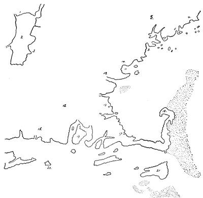
NEW ENGLAND, 1650.
This is a reduction of a sketch of a part of a manuscript Map of North America, dated 1650, of which a drawing is given in the Massachusetts Archives; Documents Collected in France, ii. 61. The key is as follows:—
1. Sauvages Hurons. 2. Lac des Iroquois [Lake Champlain]. 3. Sauvages Iroquois. 4. Sauvages Malectites. 5. Sauvages Etechemins. 6. Pemicuit [Pemaquid]. 7. Pentagouet. 8. Isle des Monts Deserts. 9. Baye de Kinibequi. 10. Sauvages Kanibas. 11. Caskobé [Casco Bay]. 12. Pescadoué [Piscataqua]. 13. Selem [Salem]. 14. Baston [Boston]. 15. Nova Anglia. 16. Sauvages Pequatis [Pequods]. 17. Plymuth. 18. Cap Malabar. 19. Sauvages Narhicans [Narragansetts]. 20. Isle de Bloque [Block Island]. 21. Isle de Nantochyte [Nantucket].
For the next twenty years the Dutch plotting was the one in vogue. Visscher, in 1652, disjoined the two principal islands south of Cape Cod, and gave a better shape to that peninsula; but Crane Bay (Plymouth) continued to be more prominent than Boston. The French map of Sanson (1656) so far followed the Dutch as to recognize the claims of “Nouveau Pays Bas” to stretch through Connecticut, Rhode Island, and Plymouth Colony, as shown in the sketch in chap. xi. The old Dutch mistakes and the Dutch names characterize Hendrick Doncker’s Paskaert, in 1659, and other of the Hollanders’ sea-charts of this time. In 1660, François du Creux’s (Creuxius) Historia Canadensis converts into a Latin nomenclature, in a curious jumble, the names of the English, Dutch, and French. This map is given in fac-simile in Shea’s Mississippi, p. 50, and also in Vol. IV. of the present work. The next year (1661) Van Loon’s Pascaerte was based on Blaeu and De Laet, and his Zee-Atlas, though not recognized by Asher, represents the best knowledge of the time. There is a copy in Harvard College Library. There are other maps of Visscher of about this same time, in which Cape Cod becomes as excessively attenuated as it had been too large before.
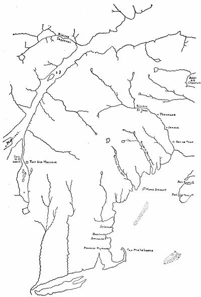
NEW ENGLAND, 1680
This follows a manuscript French map preserved in the Depot des Cartes et Plans at Paris, as shown in a sketch by Mr. Poore in the Massachusetts Archives; Documents Collected in France, iii. 11.
Of the later Dutch charts or maps, the chief place must be given to that in Roggeveen’s Sea-Atlas, which is called in the English version The Burning Fen, and which still insists in calling the Cape Cod peninsula in 1675 a part of “Nieuw Holland,” as does one of Jannson’s of about the same date, in which Smith’s names survive marvellously when those of other towns had long taken their places. A map, La Nouvelle Belgique, covering also New England, and fashioned on one of Jannson’s, is annexed to an article, “Une Colonie Néerlandaise,” by Colonel H. Wauwermans, in the Bulletin de la Société Géographique d’Anvers, iv. 173. The Blaeu map, “Nova Belgica et Anglia Nova,” found in the Atlas of 1685, still preserves most of the older Dutch falsities; and that geographer made no one of these errors so conspicuous as he did in making still nearer than before the approach of “Lacus Irocociensis” to Narragansett Bay. A short dotted boundary-line is made to connect them, and he dispelled the old Dutch claim to southeastern New England, by putting “Nieu Engelland” east of this line, and “Nieu Nederlandt” west of it. This map was substantially followed in Allard’s Minor Atlas, of a few years later. A new English cartography sprang up when there came a demand for geographical knowledge, as the events of Philip’s War engaged general attention. The royal geographer Speed issued in 1676 a map of New England and New York in his Prospect; but he seems to have followed Visscher and the other Dutch authorities implicitly, as did Coronelli and Tillemon in the New England parts of their map of Canada issued in 1688. Stevens, in his Bibliotheca Geographica, p. 229, notes an English map of New England and New York, which he supposes to belong to 1690, “sold by T. Bassett, in Fleet Street,” which is seemingly enlarged from so early a Dutch map as De Laet’s of 1625. The text of Josselyn’s Voyages was used as the basis of A Description of New England, which accompanied in folio a folded plate, entitled “Mapp of New England, by John Seller, Hydrographer to the King.” It is without date, but is mentioned in the London Gazette in 1676, and could not have appeared earlier than 1674, when Josselyn’s book was printed. There is a copy in Harvard College Library; and it shows the coast from Casco Bay to New York, with a corresponding interior. These are precisely the bounds in the map which is given in Mather’s Magnalia in 1702, and which seems, in parts at least, to have been drawn from Seller’s. Sabin (Dictionary, vol. xiii. no. 52,629) gives A Description of New England in general, with a Description of the Town of Boston in particular, London, John Seller, 1682, 4º. Seller is also known to have issued a small sketch map in his New England Almanac, 1685 (copy in Harvard College Library); and still another, of which a fac-simile is given in Palfrey’s New England, iii. 489. There is a map (5 x 4½ inches) of New England by Robert Morden in R. Blome’s Present State of his Majesty’s Isles and Territories in America, 1687, p. 210, which is based on Seller’s, and which has been reproduced by the Bradford Club in their Papers concerning the Attack on Hatfield and Deerfield, New York, 1859. A different map, extending to New France and Greenland, is given in the Amsterdam editions of Blome, 1688 and 1715. Hubbard’s map, accompanying his Narrative of the Troubles in New England, 1677, a rude woodcut,—the first attempt at such work in the colony,—extends only to the Connecticut westerly; but northerly it goes far enough to take in the White Hills, which in the London reissue of the map are called “Wine Hills.” This is also given by Palfrey, iii. 155, after the London plate, and further notes upon it will be found in the Memorial History of Boston, i. 328. There is also a detailed delineation of the New England coast in John Thornton’s Atlas Maritimus, 1701-21.
In this enumeration of the maps or charts which give New England, or any considerable part of it, on a scale sufficient for detail, it is thought that every significant draft is mentioned, though some repetitions, particularly by the Dutch, have been purposely omitted.
Modern maps of New England, which indicate the condition of this period, will be found in Palfrey’s New England, vol. i., showing the geography of 1644, and in vol. iii. that of 1689; and in Uhden’s Geschichte der Congregationalisten, Leipsic, 1840.