Chapter X · (continued 2)
Reading edition
The same picture is reproduced in the later, 1673, edition of Montanus, p. 143, and in Ogilby’s America, 1671, p. 171, where the description also follows Montanus, with aid from Denton. (Carter-Brown Catalogue, ii. 1,067, 1,092.) Montanus’s account is translated in the Documentary History of New York, iv. 75, 116, with a fac-simile of the view in question. Cf. also Gay’s Popular History of the United States, iii. 1, and the fac-simile issued, with descriptive notes, by J. W. Moulton in 1825 as New York One Hundred and Seventy Years Ago; and Watson’s Olden Times in New York, 1832.
The picture is also given in fac-simile in Mr. Lenox’s edition of Jogues’s Novum Belgium, edited by J. G. Shea, and in N. E. Hist. and Geneal. Reg., July, 1882, with a paper by J. R. Stanwood on the settlement of New Netherland. Muller, of Amsterdam in one of his catalogues, of recent years, offered for 250 marks a water-color drawing made in 1650, which he claimed as the original sketch upon which the engraver in Montanus worked. Muller, Catalogue of American Portraits, etc., no. 305. This view is now in the New York Historical Society’s Library. It is inscribed “In ‘t schip Lydia door Laurens Harmen Zn Block, Ao 1650.” There is no record of any ship of such name arriving at New Amsterdam, and this together with certain changes in the picture, as compared with Montanus, have led good judges to suspect that it is a copy of that view, by one who was never in New Amsterdam, rather than its original. The paper and frame are old, at all events.
A view purporting to represent the town in 1667 is given in Valentine’s New York City Manual, 1851, p. 131, and in his History of New York City, p. 71.
The view of which an engraving is herewith given is from a map entitled Totius Neobelgii nova et accuratissima tabula, ... Typis Caroli Allard, Amstelodami.

NEW YORK, OR NEW AMSTERDAM, 1673.
The reference-key to the view is as follows:—
A. Fort Orangiensche oft N. Albanische Jachten. B. Vlagge-spil, daer de Vlag wordt opgehaelt, alsercomen schepen in dese Haven. C. Fort Amsterdam, genaemt Jeams-fort bij de Engelsche. D. Gevangen-huijs. E. Gereformeede Kerck. F. Gouverneurs-Huijs. G. ’t magazijn. H. De Waeg. I. Heeren-gracht. K. Stadt huijs. L. Luthersche Kerck. M. Waterpoort. N. Smidts-vallij. O. Landtpoort. P. Weg na ’tversche Water. Q. Wint-molen. R. Ronduijten. S. Stuijvesants Huijs. T. Oost-Rivier, lopende tusschen ’t Eijlandt Manhatans, en Jorckshire, oft ‘t lange Eijlandt.
The view is inscribed: “Nieuw-Amsterdam, onlangs Nieuw jorck genamt, ende hernomen bij de Nederlanders op den 24 Aug., 1673, eindelijk aan de Engelse weder afgestaan.” It took the place of the engraved view, already mentioned as appearing in the first edition of Allard’s map, and was probably etched by Romeyn de Hooghe, a distinguished artist of the day, when Hugo Allard retouched his old plate to produce an engraved map to meet the interest raised by the recapture of the town. It also did service in the later issues of the same plate by Carolus Allard and the Ottens, and was reproduced in an inferior way by Lotter on his map. See Asher’s List of Maps and Views, p. 20. A view of 1679 is given on a later page, with its history.
The annexed cut of the Strand follows a view in The Manual of the City of New York, 1869, p. 738. The Central House, with three windows in the roof, was the earliest brick house built in the town, and was at one time the dwelling of Jacob Leisler, and had been built by his father-in-law, Vanderveen; cf. the narrative in the Manual. It is also engraved in Gay’s Popular History of the United States, iii. 14. Other houses of this period are shown in the Manual, 1847, p. 371, 1858, p. 526, and 1862, p. 522; in Valentine’s History of New York City, pp. 177, 214, 319; in Riker’s Harlem, p. 454 (Dutch Church of 1686), etc.
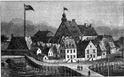
THE STRAND, NEW WHITEHALL STREET, NEW YORK.
Maps. An account of the maps of the Dutch period is given in Vol. IV. For the English period, the earliest of the town of New York was probably that supposed to have been sent home by Nicoll (1664-68) after his occupation, and of which a portion is herewith given.
Of about the same date is the original of the Hudson River Map (1666), which will be found in the next volume. Then came the map of the province by Nicolas Visscher, issued in the first edition of his Atlas Minor about 1670.[707] Not far from the same time (1671) appeared the map which is common to Montanus’s Nieuwe en Onbekende Weereld and to Ogilby’s great folio America, which shows the coast from the Penobscot to the Chesapeake, and is entitled “Novi Belgii, etc., delineatio.” It closely resembles Jansson’s earlier map. The Allard map of 1673, from which our engraved view is taken, was the second by that cartographer of New Netherland, who retouched the plate of the earlier one, which had been mainly a reproduction of N. J. Visscher’s, as the later one of Schenk and Valch (1690) was. Asher says (nos. 13, 15, 16) that Allard in this second map confined his additions to new names in the Dutch regions. The same plate was later used by Carolus Allard, and as late as 1740-50 by Ottens.
About 1680, in Danckers’ Atlas, published at Amsterdam, is found a map, “Novi Belgii, etc., tabula, multis in locis emendata a J. Danckers,” which, however, in Asher’s opinion was but a revamping of the earlier Visscher plate.[708] The map which N. J. Visscher published about 1640 was reissued about 1690 by Nicolas Visscher, “Novi Belgii, etc., tabula, multis in locis emendata,” making use of the work of Montanus and Allard, of which there were also later issues. (Asher’s List, no. 14; Muller, no. 2,276.) An eclectic map, showing the province at this period, was made up from Montanus, Roggeveen, and others, by J. P. Bourjé, and appeared in Lambrechtsen’s Korte Beschryving, Middelburg, 1818. The maps of Nicolas Visscher in Sanson’s Atlas Nouveau (1700), and of Henry Hondius and Homan, belong to a later period.
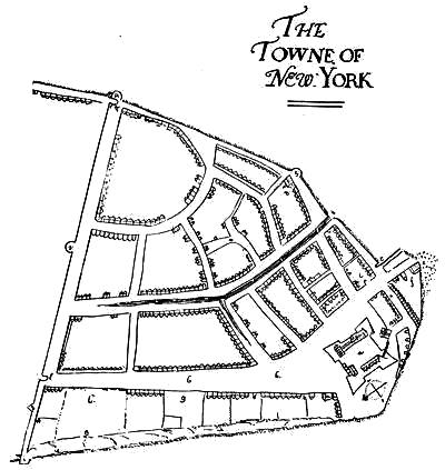
SKETCH PLAN OF NEW YORK CITY, 1664-68.
This is a reduced reproduction of the fac-simile in Valentine’s New York City Manual, 1863, of one of the sheets of Nicoll’s map of Manhattan Island, preserved in the British Museum. It bears an attestation of correct correspondence with the original, from Richard Simms, of the Museum, who transmitted in 1862 the copy to George H. Moore, then of the Historical Society. Cf. also another representation in Valentine’s Manual, 1859, P. 548, and in his History, p. 226.
Of the charts of the coast about New York, there were two standard atlases of this period, the Zee-Atlas of Pieter Goos, of which there were editions in 1666, 1668, 1673, 1675, 1676,—some of them with French text. (Asher’s List, no. 22-24; Muller’s Catalogue, 1877, no. 1254.) Better executed are the charts in the special American collection issued at Amsterdam by Arent Roggeveen under the title of Het Eerste Deel van het Brandende Veen, 1675, and known in the English edition as The Burning Fen. Asher also adds the charts of Van Keulen, remarking, however, upon their inaccurate coast-lines.
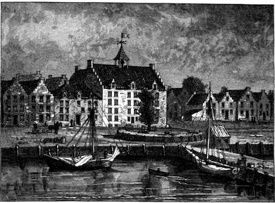
THE STADTHUYS IN NEW YORK, 1679.—BREVOORT’S DRAWING.
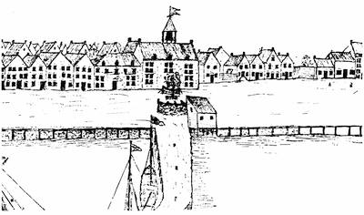
THE STADTHUYS, 1679.—ORIGINAL SKETCH.
Descriptions. Edward Melton was in New York in 1668, and in his Zee-en Landreizen, Amsterdam, 1681, and again 1702, he gives a detailed description of the place, borrowing somewhat from Montanus. (Asher’s Essay, no. 17; and Carter-Brown Catalogue, ii. 1,221, which says the later editions were issued in 1704-1705.) Though an Englishman, his account was not published in the original, and we owe the earliest one in English to Daniel Denton, whose Brief Descriptions of New York appeared in London in 1670. It is now very rare. (Sabin’s Dictionary, v. 350.) It is a small quarto, and Rich priced it in 1832 at £1 12s. There are copies in Harvard College Library; in the State Library, Albany; besides two copies in the Carter-Brown Library, with different imprints. (Catalogue, ii. 1,038.) Sabin, in the Menzies Catalogue, says he had sold a copy for $275, and at that sale it brought $220. (Cf. Brinley Catalogue, no. 2,778.) It was reprinted by the Pennsylvania Historical Society in 1845, 16 pp., and by Wm. Gowan in New York the same year, with an Introduction by Gabriel Furman, 57 pp.
A few years later we have another description in the Journal of a Voyage to New York, 1679-80, by Jasper Dankers and Peter Sluyter, which was translated from the original Dutch manuscript by Henry C. Murphy, and, enriched by an Introduction from the same hand, appeared in 1867 as vol. i. of the Memoirs of the Long Island Historical Society, and also separately. Some particulars of Danckaerts or Dankers are noted in Mass. Hist. Soc. Proc., 1874, p. 309. The MS., when found by Mr. Frederick Muller, of Amsterdam, from whom Mr. Murphy procured it, was accompanied by certain drawings of the town, seemingly taken on the spot. These are given in Mr. Murphy’s volume in fac-simile, with descriptions by Mr. J. Carson Brevoort, who has also re-drawn certain parts of them with better perspective, and other rectifications. The re-drawings are also engraved. The originals consist: (1) of a view of the Narrows, looking out to sea; (2) of a long panoramic view of the town as seen from the Brooklyn shore; (3) the East River shore looking south; (4) a view down the island from the northern edge of the settlement, with the Hudson River on the right, and a supposable East River on the left. The views which Mr. Brevoort has rectified are no. 4; the Stadthuys, with adjacent buildings and half-moon battery, extracted from no. 2; and three parts of no. 3, namely the Dock, the Water-gate (foot of Wall Street), and the shore north of the Water-gate. A reduction of the Brevoort Stadthuys view and the original, full size, are given herewith. This building stood on the corner of Pearl Street and Coentys slip, was erected as a city tavern in 1642, became a city hall in 1655, and was torn down in 1700. The battery when built projected into the river. There are other views of the Stadthuys given in Valentine’s Manual, (1655-56) p. 336, (1852) p. 378, (1853) p. 472; his History, p. 52; Lamb’s New York, i. 106; Gay’s Popular History of the United States, ii. 139, etc. Mr. J. W. Gerard published a monograph in 1875, Old Stadthuys of New Amsterdam.
In the train of Andros, and as his chaplain, a Rev. Charles Wooley came to New York in 1678, and his Journal of Two Years was published in 1701. (Historical Magazine, i. 371.) There is a copy in Harvard College Library. It was edited in 1860, with notes by Dr. O’Callaghan, as Gowan’s Bibliotheca Americana, no. 2; and no. 3 of the same series, J. Miller’s Description of the Province and City of New York (1695), though of a little later date, is best examined in the same connection. It is edited by John G. Shea, as Gowan printed it in 1862. Cf. also C. Lodwick’s “New York in 1692,” in 2 N. Y. Hist. Coll., vol. ii.