Chapter I · (continued 3)
Reading edition
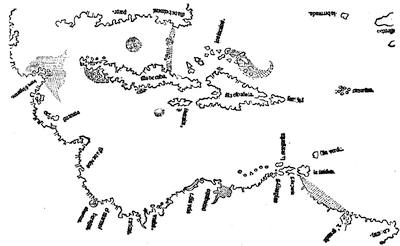
PETER MARTYR, 1511.
The 1511 map, here given in fac-simile after another fac-simile in the Carter-Brown Catalogue, has been several times reproduced,—in Stevens’s Notes, pl. 4; J. H. Lefroy’s Memorials of the Bermudas, London, 1877; H. A. Schumacher’s Petrus Martyr, New York, 1879; and erroneously in H. H. Bancroft’s Central America, i. 127. Cf. also Harrisse, Bibl. Amer. Vet., no. 66; Additions, p. viii and no. 41; Notes on Columbus, p. 9; and his Les Cortereal, p. 113. Copies of the book are in the Carter-Brown, Lenox, Daly, and Barlow libraries. A copy (no. 1605*) was sold in the Murphy sale. Quaritch has priced a perfect copy at £100. The map gives the earliest knowledge which we have of the Bermudas. Cf. the “Descripcion de la isla Bermuda” (1538), in Buckingham Smith’s Coleccion, p. 92.
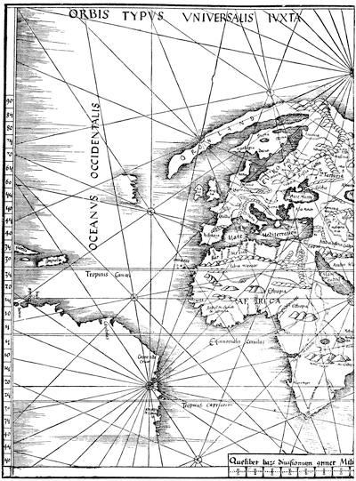
PART OF THE ORBIS TYPUS UNIVERSALIS (PTOLEMY, 1513).
The European prolongation of Gronland resembles that of a Portuguese map of 1490. Another reduced fac-simile is given in Ruge’s Geschichte des Zeitalters der Entdeckungen (1881.) These 1513 maps were reprinted in the Strasburg, 1520, edition of Ptolemy (copies in the Carter-Brown Library and in the Murphy Catalogue, no. 2,053), and were re-engraved on a reduced scale, but with more elaboration and with a few changes, for the Ptolemies of 1522 and 1525; and they were again the basis of those in Servetus’ Ptolemy of 1535.
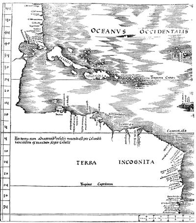
TABULA TERRE NOVE, OR THE ADMIRAL’S MAP (PTOLEMY, 1513).
Kohl remarks that the names on the South American coast (north part) are carried no farther than Ojeda went in 1499, and no farther south than Vespucius went in 1503; while the connection made of the two Americas was probably conjectural. Other fac-similes of the map are given in Varnhagen’s Premier voyage de Vespucci, in Weise’s Discoveries of America, p. 124; and in Stevens’s Historical and Geographical Notes, pl. 2. Cf. Santarem (Childe’s tr.), 153. Wieser, in his Magalhâes-Strasse (Innsbruck, 1881), p. 15, mentions a manuscript note-book of Schöner, the globe-maker, preserved in the Hof-bibliothek at Vienna, which has a sketch resembling this 1513 map. Harrisse (Les Cortereal, pp. 122, 126) has pointed out the correspondence of its names to the Cantino map, though the Waldseemüller map has a few names which are not on the Cantino. Again, Harrisse (Les Cortereal, p. 128) argues from the fact that the relations of Duke René with Portugal were cordial, while they were not so with Spain, and from the resemblance of René’s map in the Ptolemy of 1513 to that of Cantino, that the missing map upon which Waldseemüller is said to have worked to produce, with René’s help, the so-called “Admiral’s map,” was the original likewise of that of Cantino.
The earliest Spanish map after that of La Cosa which has come down to us is the one which is commonly known as Peter Martyr’s map. It is a woodcut measuring 11 × 7½ inches, and is usually thought to have first appeared in the Legatio Babylonica, or Martyr’s first decade, at Seville, 1511; but Harrisse is inclined to believe that the map did not originally belong to Martyr’s book, because three copies of it in the original vellum which he has examined do not have the map. Quaritch[424] says that copies vary, that the leaf containing the map is an insertion, and that it is sometimes on different folios. Thus of two issues, one is called a second, because two leaves seem to have been reprinted to correct errors, and two new leaves are inserted, and a new title is printed. It is held by some that the map properly belongs to this issue. Brevoort[425] thinks that the publication of the map was distasteful to the Spanish Government (since the King this same year forbade maps being given to foreigners); and he argues that the scarcity of the book may indicate that attempts were made to suppress it.[426]
The maker of the 1513 map as we have it was Waldseemüller, or Hylacomylus, of St. Dié, in the Vosges Mountains; and Lelewel[427] gives reasons for believing that the plate had been engraved, and that copies were on sale as early as 1507. It had been engraved at the expense of Duke René II. of Lorraine, from information furnished by him to perfect some anterior chart; but the plate does not seem to have been used in any book before it appeared in this 1513 edition of Ptolemy.[428] It bears along the coast this legend: “Hec terra adjacentibus insulis inventa est per Columbū ianuensem ex mandato Regis Castelle;” and in the Address to the Reader in the Supplement appears the following sentence, in which the connection of Columbus with the map is thought to be indicated: “Charta antē marina quam Hydrographiam vocant per Admiralem [? Columbus] quondam serenissi. Portugalie [? Hispaniæ] regis Ferdinandi ceteros denique lustratores verissimis pagratiōibus lustrata, ministerio Renati, dum vixit, nunc pie mortui, Ducis illustris. Lotharingie liberalius prelographationi tradita est.”[429]
This “Admiral’s map” seems to have been closely followed in the map which Gregor Reisch annexed to his popular encyclopædia,[430] the Margarita philosophica, in 1515; though there is some difference in the coast-names, and the river mouths and deltas on the coast west of Cuba are left out.
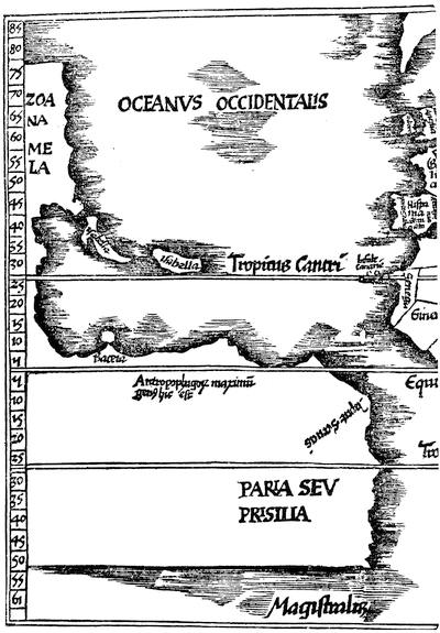
PART OF REISCH’S MAP, 1515.
There is another fac-simile in Stevens’s Historical and Geographical Notes, pl. 4. An edition of Reisch appeared at Freiburg in 1503 (Murphy, no. 3,089); but in 1504 there were two editions, with a mappemonde which had no other reference to America than in the legend: “Hic non terra sed mare est in quo miræ magnitudinis insulæ sed Ptolemæo fuerunt incognitæ.” Some copies are dated 1505. (Murphy, no. 3,090.) A copy dated 1508, Basle, “cum additionibus novis” (Quaritch, no. 12,363; Baer’s Incunabeln, 1884, no. 64, at 36 marks; and Murphy, no. 2,112*) had the same map. The 1515 edition had the map above given. (Harrisse, Bibl. Amer. Vet., no. 82; Additions, no. 45, noting a copy in the Imperial Library at Vienna. Kohl copies in his Washington Collection from one in the library at Munich.) The Basle edition of 1517 has a still different woodcut map. (Beckford, Catalogue, vol. iii. no. 1,256; Murphy, no. 2,112**.) Not till 1535 did an edition have any reference to America in the text. (Bibl. Amer. Vet., no. 208.) The latest edition is that of 1583, Basle, with a mappamonde showing America. (Leclerc, no. 2,926.) Cf. further in D’Avezac’s Waltzemüller, p. 94; Kunstmann’s Entdeckung Amerikas, p. 130; Stevens’s Notes, p. 52; Kohl, Die beiden ältesten General-Karten von America, p. 33.
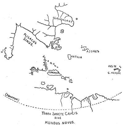
RUYSCH, 1508.[431]
Stevens and others have contended that this represents Columbus’ Ganges; but Varnhagen makes it stand for the Gulf of Mexico and the Mississippi,—a supposition more nearly like Reisch’s interpretation, as will be seen by his distinct separation of the new lands from Asia. Reisch is, however, uncertain of their western limits, which are cut off by the scale, as shown in the map; while on the other side of the same scale Cipango is set down in close proximity to it.
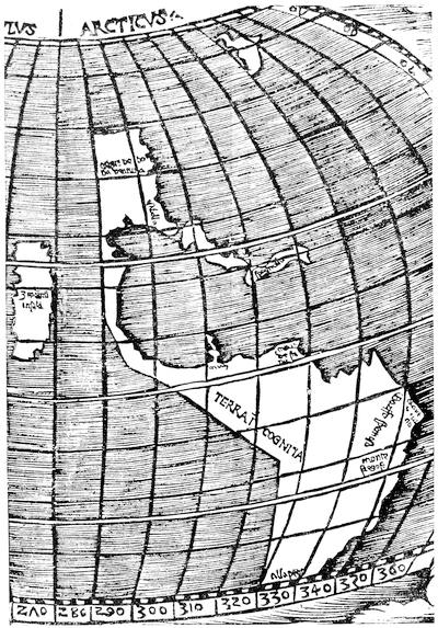
STOBNICZA, 1512.
It is held that this map shows the earliest attempt to represent on a plane a sphere truncated at the poles. Wieser (Magalhaês-Strasse, p. 11) speaks of a manuscript copy of Stobnicza’s western hemisphere, made by Glareanus, which is bound with a copy of Waldseemüller’s Cosmographiæ introductio, preserved in the University Library at Munich. Cf. Vol. III. p. 14, with references there, and Winsor’s Bibliography of Ptolemy sub anno 1512; Harrisse, Notes on Columbus, p. 178, and Bibl. Amer. Vet., nos. 69 and 95, and Additions, no. 47. The only copies of the Stobnicza Introductio in this country lack the maps. One in the Carter-Brown Library has it in fac-simile, and the other was sold in the Murphy sale, no. 2,075.
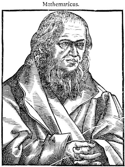
SCHÖNER.
Fac-simile of a cut in Reusner’s Icones (Strasburg, 1590), p. 127. Cf. on Schöner’s geographical labors, Doppelmayr’s Historische Nachricht von den nürnbergischen Mathematikern und Künstlern (1730); Will und Nopitsch’s Nürnbergisches Gelehrten-Lexicon (1757); Ghillany’s Erdglobus des Behaim und der des Schöner; and Varnhagen’s Schöner e Apianus (Vienna, 1872).
It has been supposed that it was a map of this type which Bartholomew Columbus, when he visited Rome in 1505, gave to a canon of St. John Lateran, together with one of the printed accounts of his brother’s voyage; and this canon gave the map to Alessandro Strozzi, “suo amico e compilatore della raccolta,” as is stated in a marginal note in a copy of the Mundus novus in the Magliabecchian library.[432]
Columbus is said to have had a vision before his fourth voyage, during which he saw and depicted on a map a strait between the regions north and south of the Antillian Sea. De Lorgues, with a convenient alternative for his saintly hero, says that the mistake was only in making the strait of water, when it should have been of land!
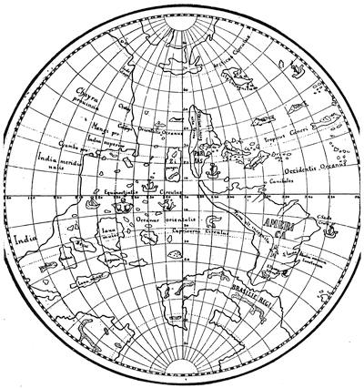
SCHÖNER, 1515.
According to Wieser (Magalhâes-Strasse, p. 19) this globe, which exists in copies at Weimar (of which Wieser gives the above sketch from Jomard’s fac-simile of the one at Frankfort, but with some particulars added from that at Weimar) and at Frankfort (which is figured in Jomard), was made to accompany Schöner’s Luculentissima quædam terræ totius descriptio, printed in 1515. Cf. Harrisse, Notes on Columbus, p. 179, and Bibl. Amer. Vet., nos. 80, 81; Murphy, no. 2,233. Copies of Schöner’s Luculentissima, etc., are in the Harvard College, Carter-Brown, and Lenox libraries.
In 1523 Schöner printed another tract, De nuper sub Castiliæ, ac Portugaliæ regibus serenissimis repertis insulis ac regionibus, descriptive of his globe, which is extremely rare. Wieser reports copies in the great libraries of Vienna and London only. Varnhagen reprinted it from the Vienna copy, at St. Petersburg in 1872 (forty copies only), under the designation, Réimpression fidèle d’une lettre de Jean Schöner, à propos de son globe, écrite en 1523. The Latin is given in Wieser’s Magalhâes-Strasse, p. 118. Johann Schoner or Schöner (for the spelling varies) was born in 1477, and died in 1547. The testimony of this globe to an early knowledge of the straits afterward made known by Magellan is examined on a later page. The notions which long prevailed respecting a large Antarctic continent are traced in Wieser’s Magalhâes-Strasse, p. 59, and in Santarem, Histoire de la cartographie, ii. 277.
Cf. on the copy at Frankfort,—Vol. III. p. 215, of the present History; Kohl’s General-Karten von Amerika, p. 33, and his Discovery of Maine, p. 159; Encyclopædia Britannica, x. 681; Von Richthofen’s China, p. 641; Journal of the Royal Geographical Society, xviii. 45. On the copy at Weimar, see Humboldt, Examen critique, and his Introduction to Ghillany’s Ritter Behaim.
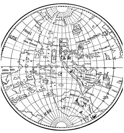
SCHÖNER, 1520.
This globe, which has been distinctively known as Schöner’s globe, is preserved at Nuremberg. There are representations of it in Santarem, Lelewel, Wieser, Ghillany’s Behaim, Kohl’s Geschichte der Entdeckungsreisen zur Magellan’s-Strasse (Berlin, 1877), p. 8; H. H. Bancroft’s Central America, i. 137; and in Harper’s Magazine, February, 1871, and December, 1882, p. 731. The earliest engraving appeared in the Jahresbericht der technischen Anstalten in Nürnberg für 1842, accompanied by a paper by Dr. Ghillany; and the same writer reproduced it in his Erdglobus des Behaim und der des Schöner (1842). The globe is signed: “Perfecit eum Bambergæ 1520, Joh. Schönerus.” Cf. Von Murr, Memorabilia bibliothecarum Noribergensium (1786), i. 5; Humboldt, Examen critique, ii. 28; Winsor’s Bibliography of Ptolemy sub anno 1522; and Vol. III. p. 214, of the present History.
We have a suspicion of this strait in another map which has been held to have had some connection with the drafts of Columbus, and that is the Ruysch map, which appeared in the Roman Ptolemy of 1508,[433] the earliest published map, unless the St. Dié map takes precedence, to show any part of the new discoveries.
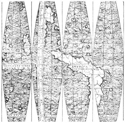
THE TROSS GORES, 1514-1519.
Twelve gores of a globe found in a copy of the Cosmographiæ introductio, published at Lugduni, 1514 (?), and engraved in a catalogue of Tross, the Paris bookseller, in 1881 (nos. xiv. 4,924). The book is now owned by Mr. C. H. Kalbfleisch, of New York. Harrisse (Cabots, p. 182) says the map was engraved in 1514, and ascribes it to Louis Boulenger. (Cf. Vol. III. p. 214, of the present History.) There are two copies of this edition of the Cosmographiæ introductio in the British Museum; and D’Avezac (Waltzemüller, p. 123) says the date of it cannot be earlier than 1517. Harrisse says he erred in dating it 1510 in the Bibl. Amer. Vet., no. 63. Cf. Winsor’s Bibliography of Ptolemy sub anno 1522.
It seems from its resemblance to the La Cosa chart to have been kept much nearer the Columbian draft than the geographer of St. Dié, with his Portuguese helps, was contented to leave it in his map. In La Cosa the vignette of St. Christopher had concealed the mystery of a westerly passage;[434] Ruysch assumes it, or at least gives no intimation of his belief in the inclosure of the Antillian Sea. Harrisse[435] has pointed out how an entirely different coast-nomenclature in the two maps points to different originals of the two map-makers. The text of this 1508 edition upon “Terra Nova” and “Santa Cruz” is by Marcus Beneventanus. There are reasons to believe that the map may have been issued separately, as well as in the book; and the copies of the map in the Barlow Collection and in Harvard College Library are perhaps of this separate issue.[436]
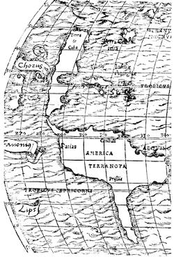
MÜNSTER, 1532.
The distinctive features both of the La Cosa and the Ruysch drafts, of the Cantino map and of the Waldseemüller or St. Dié map of 1513, were preserved, with more or less modifications in many of the early maps. The Stobnicza map—published in an Introductio to Ptolemy at Cracow in 1512—is in effect the St. Dié map, with a western ocean in place of the edge of the plate as given in the 1513 Ptolemy, and is more like the draft of Reisch’s map published three years later.
There are other drawings of this map in Stevens’s Notes; in Nordenskiöld’s Bröderna Zenos (Stockholm, 1883); etc.
The Schöner globe of 1515, often cited as the Frankfort globe; the Schöner globe of 1520; the so-called Tross gores of 1514-1519; the map of Petrus Apianus[437]—or Bienewitz, as he was called in his vernacular—which appeared in the Polyhistoria of Solinus, edited by the Italian monk Camers, and also in 1522 in the De orbis situ of Pomponius Mela, published by Vadianus,—all preserve the same characteristics with the St. Dié map, excepting that they show the western passage referred to in Columbus’ dream, and so far unite some of the inferences from the map of Ruysch. There was a curious survival of this Cantino type, particularly as regards North America for many years yet to come, as seen in the map which Münster added to the Basle edition of the Novus orbis in 1532 and 1537, and in the drawing which Jomard gives[438] as from “une cassette de la Collection Trivulci, dite Cassettina all’Agemina.” This last drawing is a cordiform mappemonde, very like another which accompanied Honter’s Rudimenta cosmographica in 1542, and which was repeated in various editions to as late a period as 1590. Thus it happened that for nearly a century geographical views which the earliest navigators evolved, continued in popular books to convey the most inadequate notion of the contour of the new continent.[439]
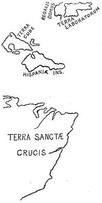
SYLVANUS’ MAP, 1511.
The map is given in its original projection in Lelewel, pl. xlv., and on a greatly reduced scale in Daly’s Early Cartography, p. 32. There are copies of this 1511 Ptolemy in the Lenox, Carter-Brown, Astor, Brevoort, Barlow, and Kalbfleisch collections. Cf. Murphy Catalogue, no. 2,051, for a copy now in the American Geographical Society’s Library, and references in Winsor’s Bibliography of Ptolemy sub anno 1511.
In the same year with the publication of the Peter Martyr map of 1511, an edition of Ptolemy, published at Venice and edited by Bernardus Sylvanus, contained a mappemonde on a cordiform projection,—which is said to be the first instance of the use of this method in drafting maps. What is shown of the new discoveries is brought in a distorted shape on the extreme western verge of the map; and to make the contour more intelligible, it is reduced in the sketch annexed to an ordinary plane projection. It is the earliest engraved map to give any trace of the Cortereal discoveries[440] and to indicate the Square, or St. Lawrence, Gulf. It gives a curious Latinized form to the name of the navigator himself in “Regalis Domus” (Cortereal), and restores Greenland, or Engronelant, to a peninsular connection with northwestern Europe as it had appeared in the Ptolemy of 1482.
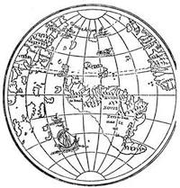
THE LENOX GLOBE.
It will be seen that, with the exception of the vague limits of the “Regalis Domus,” there was no sign of the continental line of North America in this map of Sylvanus. Much the same views were possessed by the maker of the undated Lenox globe, which probably is of nearly the same date, and of which a further account is given elsewhere.[441]
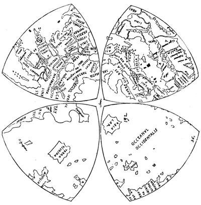
DA VINCI, NORTHERN HEMISPHERE (original draft reduced).
Another draft of a globe, likewise held to be of about the same date, shows a similar configuration, except that a squarish island stands in it for Florida and adjacent parts of the main. This is a manuscript drawing on two sheets preserved among the Queen’s collections at Windsor; and since Mr. R. H. Major made it known by a communication, with accompanying fac-similes, in the Archæologia,[442] it has been held to be the work of Leonardo da Vinci, though this has been recently questioned.[443]
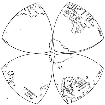
DA VINCI, SOUTHERN HEMISPHERE (original draft reduced).
Another sketch of this hemisphere is given in Harper’s Monthly, December, 1882, p. 733.
If deprived of the associations of that august name, the map loses much of its attraction; but it still remains an interesting memorial of geographical conjecture. It is without date, and can only be fixed in the chain of cartographical ideas by its internal evidence. This has led Major to place it between 1512 and 1514, and Wieser to fix it at 1515-1516.[444] A somewhat unsatisfactory map, since it shows nothing north of “Ysabella” and “Spagnollo,” is that inscribed Orbis typus universalis juxta hydrographorum traditionem exactissime depicta, 1522, L. F., which is the work of Laurentius Frisius, and appeared in the Ptolemy of 1522.[445]
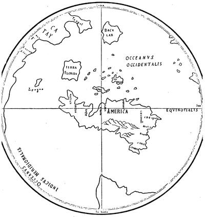
DA VINCI (newly projected).
This follows the projection as given by Wieser in his Magalhaês-Strasse, who dates it 1515-1516.
A new element appears in a map which is one of the charts belonging to the Yslegung der Mer-Carthen oder Cartha Marina, said also to be the work of Frisius, which was issued in 1525, in exposition of his theories of sea-charts.[446]
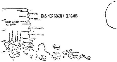
CARTA MARINA OF FRISIUS, 1525.
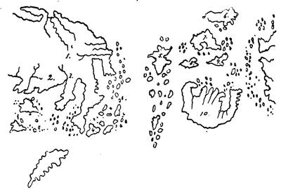
COPPO, 1528.
This is drawn from a sketch given by Kohl in his manuscript, “On the Connection of the New and Old World on the Pacific Side,” preserved in the American Antiquarian Society’s Library. There is another copy in his Washington Collection.
The map is explained by the following key: 1. Asia. 2. India. 3. Ganges. 4. Java major. 5. Cimpangi [Japan]. 6. Isola verde [Greenland?]. 7. Cuba. 8. Iamaiqua. 9. Spagnola. 10. Monde nuova [South America].
The map is of interest as the sole instance in which North America is called a part of Africa, on the supposition that a continental connection by the south enclosed the “sea toward the sunset.” The insular Yucatan will be observed in the annexed sketch, and what seems to be a misshapen Cuba. The land at the east seems intended for Baccalaos, judging from the latitude and the indication of fir-trees upon it. This map is one of twelve engraved sheets constituting the above-named work, which was published by Johannes Grieninger in 1530. Friess, or Frisius, who was a German mathematician, and had, as we have seen, taken part in the 1522 Ptolemy, says that he drew his information in these maps from original sources; but he does not name these sources, and Dr. Kohl thinks the maps indicate the work of Waldseemüller.
Among the last of the school of geographers who supposed North America to be an archipelago, was Pierro Coppo, who published at Venice in 1528 what has become a very rare Portolano delli lochi maritimi ed isole der mar.[447]