Part 2 — CHAPTER I.
Reading edition
THE GEOGRAPHICAL KNOWLEDGE OF THE ANCIENTS CONSIDERED IN RELATION TO THE DISCOVERY OF AMERICA.
BY WILLIAM H. TILLINGHAST,
Assistant Librarian of Harvard University.
AS Columbus, in August, 1498, ran into the mouth of the Orinoco, he little thought that before him lay, silent but irrefutable, the proof of the futility of his long-cherished hopes. His gratification at the completeness of his success, in that God had permitted the accomplishment of all his predictions, to the confusion of those who had opposed and derided him, never left him; even in the fever which overtook him on the last voyage his strong faith cried to him, “Why dost thou falter in thy trust in God? He gave thee India!” In this belief he died. The conviction that Hayti was Cipangu, that Cuba was Cathay, did not long outlive its author; the discovery of the Pacific soon made it clear that a new world and another sea lay between the landfall of Columbus and the goal of his endeavors.
The truth, when revealed and accepted, was a surprise more profound to the learned than even the error it displaced. The possibility of a short passage westward to Cathay was important to merchants and adventurers, startling to courtiers and ecclesiastics, but to men of classical learning it was only a corroboration of the teaching of the ancients. That a barrier to such passage should be detected in the very spot where the outskirts of Asia had been imagined, was unexpected and unwelcome. The treasures of Mexico and Peru could not satisfy the demand for the products of the East; Cortes gave himself, in his later years, to the search for a strait which might yet make good the anticipations of the earlier discoverers. The new interpretation, if economically disappointing, had yet an interest of its own. Whence came the human population of the unveiled continent? How had its existence escaped the wisdom of Greece and Rome? Had it done so? Clearly, since the whole human race had been renewed through Noah, the red men of America must have descended from the patriarch; in some way, at some time, the New World had been discovered and populated from the Old. Had knowledge of this event lapsed from the minds of men before their memories were committed to writing, or did reminiscences exist in ancient literatures, overlooked, or misunderstood by modern ignorance? Scholars were not wanting, nor has their line since wholly failed, who freely devoted their ingenuity to the solution of these questions, but with a success so diverse in its results, that the inquiry is still pertinent, especially since the pursuit, even though on the main point it end in reservation of judgment, enables us to understand from what source and by what channels the inspiration came which held Columbus so steadily to his westward course.
Although the elder civilizations of Assyria and Egypt boasted a cultivation of astronomy long anterior to the heroic age of Greece, their cosmographical ideas appear to have been rude and undeveloped, so that whatever the Greeks borrowed thence was of small importance compared with what they themselves ascertained. While it may be doubted if decisive testimony can be extorted from the earliest Grecian literature, represented chiefly by the Homeric and Hesiodic poems, it is probable that the people among whom that literature grew up had not gone, in their conception of the universe, beyond simple acceptance of the direct evidence of their senses. The earth they looked upon as a plane, stretching away from the Ægean Sea, the focus of their knowledge, and ever less distinctly known, until it ended in an horizon of pure ignorance, girdled by the deep-flowing current of the river Oceanus. Beyond Oceanus even fancy began to fail: there was the realm of dust and darkness, the home of the powerless spirits of the dead; there, too, the hemisphere of heaven joined its brother hemisphere of Tartarus.[259] This conception of the earth was not confined to Homeric times, but remained the common belief throughout the course of Grecian history, underlying and outlasting many of the speculations of the philosophers.
That growing intellectual activity which was signalized by a notable development of trade and colonization in the eighth century, in the seventh awoke to consciousness in a series of attempts to formulate the conditions of existence. The philosophy of nature thus originated, wherein the testimony of nature in her own behalf was little sought or understood, began with the assumption of a flat earth, variously shaped, and as variously supported. To whom belongs the honor of first propounding the theory of the spherical form of the earth cannot be known. It was taught by the Italian Pythagoreans of the sixth century, and was probably one of the doctrines of Pythagoras himself, as it was, a little later, of Parmenides, the founder of the Eleatics.[260]
In neither case can there be a claim for scientific discovery. The earth was a sphere because the sphere was the most perfect form; it was at the centre of the universe because that was the place of honor; it was motionless because motion was less dignified than rest.
Plato, who was familiar with the doctrines of the Pythagoreans, adopted their view of the form of the earth, and did much to popularize it among his countrymen.[261] To the generation that succeeded him, the sphericity of the earth was a fact as capable of logical demonstration as a geometrical theorem. Aristotle, in his treatise “On the Heaven,” after detailing the views of those philosophers who regarded the earth as flat, drum-shaped, or cylindrical, gives a formal summary of the grounds which necessitate the assumption of its sphericity, specifying the tendency of all things to seek the centre, the unvarying circularity of the earth’s shadow at eclipses of the moon, and the proportionate change in the altitude of stars resulting from changes in the observer’s latitude. Aristotle made the doctrine orthodox; his successors, Eratosthenes, Hipparchus, and Ptolemy, constituted it an inalienable possession of the race. Greece transmitted it to Rome, Rome impressed it upon barbaric Europe; taught by Pliny, Hyginus, Manilius, expressed in the works of Cicero, Virgil, Ovid, it passed into the school-books of the Middle Ages, whence, reinforced by Arabian lore, it has come down to us.[262]
That the belief ever became in antiquity or in the Middle Ages widely spread among the people is improbable; it did not indeed escape opposition among the educated; writers even of the Augustan age sometimes appear in doubt.[263]
The sphericity of the earth once comprehended, there follow certain corollaries which the Greeks were not slow to perceive. Plato, indeed, who likened the earth to a ball covered with party-colored strips of leather, gives no estimate of its size, although the description of the world in the Phaedo seems to imply immense magnitude;[264] but Aristotle states that mathematicians of his day estimated the circumference at 400,000 stadia,[265] and Archimedes puts the common reckoning at somewhat less than 300,000 stadia.[266] How these figures were obtained we are not informed. The first measurement of the earth which rests on a known method was that made about the middle of the third century b.c., by Eratosthenes, the librarian at Alexandria, who, by comparing the estimated linear distance between Syene, under the tropic, and Alexandria with their angular distance, as deduced from observations on the shadow of the gnomon at Alexandria, concluded that the circumference of the earth was 250,000 or 252,000 stadia.[267] This result, owing to an uncertainty as to the exact length of the stade used in the computation, cannot be interpreted with confidence, but if we assume that it was in truth about twelve per cent. too large, we shall probably not be far out of the way.[268] Hipparchus, in many matters the opponent of Eratosthenes, adopted his conclusion on this point, and was followed by Strabo,[269] by Pliny, who regarded the attempt as somewhat over-bold, but so cleverly argued that it could not be disregarded,[270] and by many others.
Fortunately, as it resulted, this overestimate was not allowed to stand uncontested. Posidonius of Rhodes (b.c. 135-51), by an independent calculation based upon the difference in altitude of Canopus at Rhodes and at Alexandria, reached a result which is reported by Cleomedes as 240,000, and by Strabo as 180,000 stadia.[271] The final judgment of Posidonius apparently approved the smaller number; it hit, at all events, the fancy of the time, and was adopted by Marinus of Tyre and by Ptolemy,[272] whose authority imposed it upon the Middle Ages. Accepting it as an independent estimate, it follows that Posidonius allowed but 500 stadia to a degree, instead of 700, thus representing the earth as about 28 per cent. smaller than did Eratosthenes.[273]
To the earliest writers the known lands constituted the earth; they were girdled, indeed, by the river Oceanus, but that was a narrow stream whose further bank lay in fable-land.[274] The promulgation of the theory of the sphericity of the earth and the approximate determination of its size drew attention afresh to the problem of the distribution of land and water upon its surface, and materially modified the earlier conception. The increase of geographical knowledge along lines of trade, conquest, and colonization had greatly extended the bounds of the known world since Homer’s day, but it was still evident that by far the larger portion of the earth, taking the smallest estimate of its size, was still undiscovered,—a fair field for speculation and fantasy.[275]
We can trace two schools of thought in respect to the configuration of this unknown region, both represented in the primitive conception of the earth, and both conditioned by a more fundamental postulate. It was a near thought, if the earth was a sphere, to transfer to it the systems of circles which had already been applied to the heavens. The suggestion is attributed to Thales, to Pythagoras, and to Parmenides; and it is certain that the earth was very early conceived as divided by the polar and solstitial circles into five zones, whereof two only, the temperate in either sphere, so the Greeks believed, were capable of supporting life; of the others, the polar were uninhabitable from intense cold, as was the torrid from its parching heat. This theory, which excluded from knowledge the whole southern hemisphere and a large portion of the northern, was approved by Aristotle and the Homeric school of geographers, and by the minor physicists. As knowledge grew, its truth was doubted. Polybius wrote a monograph, maintaining that the middle portion of the torrid zone had a temperate climate, and his view was adopted by Posidonius and Geminus, if not by Eratosthenes. Marinus and Ptolemy, who knew that commerce was carried on along the east coast of Africa far below the equator, cannot have fallen into the ancient error, but the error long persisted; it was always in favor with the compilers, and thus perhaps obtained that currency in Rome which enabled it to exert a restrictive and pernicious check upon maritime endeavor deep into the Middle Ages.[276]
Upon the question of the distribution of land and water, unanimity no longer prevailed. By some it was maintained that there was one ocean, confluent over the whole globe, so that the body of known lands, that so-called continent, was in truth an island, and whatever other inhabitable regions might exist were in like manner surrounded and so separated by vast expanses of untraversed waves. Such was the view, scarcely more than a survival of the ocean-river of the poets deprived of its further bank by the assumption of the sphericity of the earth, held by Aristotle,[277] Crates of Mallus, Strabo, Pliny, and many others. If this be called the oceanic theory, we may speak of its opposite as the continental: according to this view, the existing land so far exceeded the water in extent that it formed in truth the continent, holding the seas quite separate within its hollows. The origin of the theory is obscure, even though we recall that Homer’s ocean was itself contained. It was strikingly presented by Plato in the Phaedo, and is implied in the Atlantis myth; it may be recalled, too, that Herodotus, often depicted as a monster of credulity, had broken the bondage of the ocean-river, because he could not satisfy himself of the existence of the ocean in the east or north; and while reluctantly admitting that Africa was surrounded by water, considered Gaul to extend indefinitely westward.[278] Hipparchus revived the doctrine, teaching that Africa divided the Indian Ocean from the Atlantic in the south, so that these seas lay in separate basins. The existence of an equatorial branch of the ocean, a favorite dogma of the other school, was also denied by Polybius, Posidonius, and Geminus.[279]
The reports of traders and explorers led Marinus to a like conclusion; both he and Ptolemy, misinterpreting their information, believed that the eastern coast of Asia ran south instead of north, and they united it with the eastern trend of Africa, supposing at the same time that the two continents met also in the west.[280] The continental theory, despite its famous disciples, made no headway at Rome, and was consequently hardly known to the Middle Ages before its falsity was proved by the circumnavigation of Africa.[281]
That portion of Europe, Asia, and Africa known to the ancients, whether regarded as an island, or as separated from the rest of the world by climatic conditions merely, or by ignorance, formed a distinct concept and was known by a particular name, ἡ οἰκουμένη. Originally supposed to be circular, it was later thought to be oblong and as having a length more than double its width. Those who believed in its insularity likened its shape to a sling, or to an outspread chlamys or military cloak, and assumed that it lay wholly within the northern hemisphere. In absolute figures, the length of the known world was placed by Eratosthenes at 77,800 stadia, and by Strabo at 70,000. The latter figure remained the common estimate until Marinus of Tyre, in the second century a.d., receiving direct information from the silk-traders of a caravan route to China, substituted the portentous exaggeration of 90,000 stadia on the parallel of Rhodes, or 225°. Ptolemy, who followed Marinus in many things, shrank from the naïveté whereby the Tyrian had interpreted a seven months’ caravan journey to represent seven months’ travelling in a direct line at the rate of twenty miles a day, and cut down his figures to 180°, or 72,000 stadia.[282] It appears, therefore, that Strabo considered the known world as occupying not much over one third of the circuit of the temperate zone, while Marinus, who adopted 180,000 stadia as the measure of the earth, claimed a knowledge of two thirds of that zone, and supposed that land extended indefinitely eastward beyond the limit of knowledge.
What did the ancients picture to themselves of this unknown portion of the globe? The more imaginative found there a home for ancient myth and modern fable; the geographers, severely practical, excluded it from the scope of their survey; philosophers and physicists could easily supply from theory what they did not know as fact. Pythagoras, it is said, had taught that the whole surface of the earth was inhabited. Aristotle demonstrated that the southern hemisphere must have its temperate zone, where winds similar to our own prevailed; his successors elaborated the hint into a systematized nomenclature, whereby the inhabitants of the earth were divided into four classes, according to their location upon the surface of the earth with relation to one another.[283]
This system was furthest developed by the oceanic school. The rival of Eratosthenes, Crates of Mallus (who achieved fame by the construction of a large globe), assumed the existence of a southern continent, separated from the known world by the equatorial ocean; it is possible that he introduced the idea of providing a distinct residence for each class of earth-dwellers, by postulating four island continents, one in each quarter of the globe. Eratosthenes probably thought that there were inhabitable regions in the southern hemisphere, and Strabo added that there might be two, or even more, habitable earths in the northern temperate zone, especially near the parallel of Rhodes.[284] Crates introduced his views at Rome, and the oceanic theory remained a favorite with the Roman physicists. It was avowed by Pliny, who championed the existence of antipodes against the vulgar disbelief. In the fine episode in the last book of Cicero’s Republic, the younger Scipio relates a dream, wherein the elder hero of his name, Scipio Africanus, conveying him to the lofty heights of the Milky Way, emphasized the futility of fame by showing him upon the earth the regions to which his name could never penetrate: “Thou seest in what few places the earth is inhabited, and those how scant; great deserts lie between them, and they who dwell upon the earth are not only so scattered that naught can spread from one community to another, but so that some live off in an oblique direction from you, some off toward the side, and some even dwell directly opposite to you.”[285] Mela confines himself to a mention of the Antichthones, who live in the temperate zone in the south, and are cut off from us by the intervening torrid zone.[286]
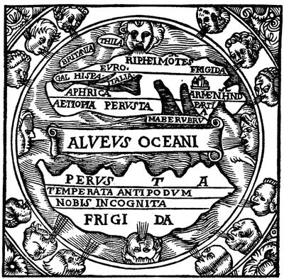
MACROBIUS
From Macrobii Ambrosii Aurelii Theodosii in Somnium Scipionis, Lib. II. (Lugduni, 1560).
Indeed, the southern continent, the other world, as it was called,[287] made a more distinct impression than the possible other continents in the northern hemisphere. Hipparchus thought that Trapobene might be a part of this southern world, and the idea that the Nile had its source there was widespread: some supposing that it flowed beneath the equatorial ocean; others believing, with Ptolemy, that Africa was connected with the southern continent. The latter doctrine was shattered by the discovery of the Cape of Good Hope; but the continent was revived when Tierra del Fuego, Australia, and New Zealand were discovered, and attained gigantic size on the maps of the sixteenth and seventeenth centuries only within the last two centuries has it shrunk to the present limits of the antarctic ice.
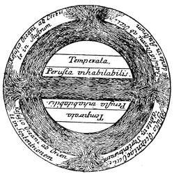
MACROBIUS
From Avr. Theodosii Macrobii Opera (Lipsiæ, 1774).
The oceanic theory, and the doctrine of the Four Worlds, as it has been termed,[288] terra quadrifiga, was set forth in the greatest detail in a commentary on the Dream of Scipio, written by Macrobius, probably in the fifth century a.d. In the concussion and repulsion of the ocean streams he found a sufficient cause for the phenomena of the tides.[289]
Such were the theories of the men of science, purely speculative, originating in logic, not discovery, and they give no hint of actual knowledge regarding those distant regions with which they deal. From them we turn to examine the literature of the imagination, for geography, by right the handmaid of history, is easily perverted to the service of myth.
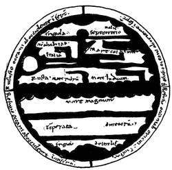
MACROBIUS
After Santarem’s Atlas, as a “mappemonde tirée d’un manuscrit de Macrobe du Xème siècle.”
The expanding horizon of the Greeks was always hedged with fable: in the north was the realm of the happy Hyperboreans, beyond the blasts of Boreas; in the east, the wonderland of India; in the south, Panchæa and the blameless Ethiopians; nor did the west lack lingering places for romance. Here was the floating isle of Æolus, brazen-walled; here the mysterious Ogygia, navel of the sea;[290] and on the earth’s extremest verge were the Elysian Fields, the home of heroes exempt from death, “where life is easiest to man. No snow is there, nor yet great storm nor any rain, but always ocean sendeth forth the breeze of the shrill west to blow cool on men.”[291] Across the ocean river, where was the setting of the sun, all was changed. There was the home of the Cimmerians, who dwelt in darkness; there the grove of Persephone and the dreary house of the dead.[292]
In the Hesiodic poems the Elysian Fields are transformed into islands, the home of the fourth race, the heroes, after death:—
“Them on earth’s utmost verge the god assign’d A life, a seat, distinct from human kind: Beside the deepening whirlpools of the main, In those blest isles where Saturn holds his reign, Apart from heaven’s immortals calm they share A rest unsullied by the clouds of care: And yearly thrice with sweet luxuriance crown’d Springs the ripe harvest from the teeming ground.”[293]
“Those who have had the courage to remain stedfast thrice in each life, and to keep their souls altogether from wrong,” sang Pindar, “pursue the road of Zeus to the castle of Cronos, where o’er the isles of the blest ocean breezes blow, and flowers gleam with gold, some from the land on glistering trees, while others the water feeds; and with bracelets of these they entwine their hands and make crowns for their heads.”[294]
The Islands of the Blest, μακάρων νῆσοι, do not vanish henceforward from the world’s literature, but continue to haunt the Atlantic through the Roman period and deep into the Middle Ages. In the west, too, were localized other and wilder myths; here were the scenes of the Perseus fable, the island of the weird and communistic sisters, the Graeae, and the Gorgonides, the homes of Medusa and her sister Gorgons, the birthplace of the dread Chimaera.[295] The importance of the far west in the myths connected with Hercules is well known. In the traditionary twelve labors the Greek hero is confused with his prototype the Tyrian Melkarth, and those labors which deal with the west were doubtless borrowed from the cult which the Greeks had found established at Gades when trade first led them thither. In the tenth labor it is the western isle Erytheia, which Hercules visits in the golden cup wherein Helios was wont to make his nocturnal ocean voyage, and from which he returns with the oxen of the giant Geryon. Even more famous was the search for the apples of the Hesperides, which constituted the eleventh labor. This golden fruit, the wedding gift produced by Gaa for Hera, the prudent goddess, doubtful of the security of Olympus, gave in charge to the Hesperian maids, whose island garden lay at earth’s furthest bounds, near where the mysterious Atlas, their father or their uncle, wise in the secrets of the sea, watched over the pillars which propped the sky, or himself bore the burden of the heavenly vault. The poets delighted to depict these isles with their shrill-singing nymphs, in the same glowing words which they applied to the Isles of the Blessed. “Oh that I, like a bird, might fly from care over the Adriatic waves!” cries the chorus in the Crowned Hippolytus,
“Or to the famed Hesperian plains, Whose rich trees bloom with gold,
To join the grief-attuned strains My winged progress hold:
Beyond whose shores no passage gave The ruler of the purple wave;
“But Atlas stands, his stately height The awfull boundary of the skies: There fountains of Ambrosia rise,
Wat’ring the seat of Jove: her stores
Luxuriant there the rich soil pours All, which the sense of gods delights.”[296]
When these names first became attached to some of the Atlantic islands is uncertain. Diodorus Siculus does not apply either term to the island discovered by the Carthaginians, and described by him in phrases applicable to both. The two islands described by sailors to Sertorius about 80 b.c. were depicted in colors which reminded Plutarch of the Isles of the Blessed, and it is certain that toward the close of the republic the name Insulae Fortunatae was given to certain of the Atlantic islands, including the Canaries. In the time of Juba, king of Numidia, we seem to distinguish at least three groups, the Insulae Fortunatae, the Purpurariae, and the Hesperides, but beyond the fact that the first name still designated some of the Canaries identification is uncertain; some have thought that different groups among the Canaries were known by separate names, while others hold that one or both of the Madeira and Cape de Verde groups were known.[297] The Canaries were soon lost out of knowledge again, but the Happy or Fortunate Islands continued to be an enticing mirage throughout the Middle Ages, and play a part in many legends, as in that of St. Brandan, and in many poems.[298]
Beside these ancient, widespread, popular myths, embodying the universal longing for a happier life, we find a group of stories of more recent date, of known authorship and well-marked literary origin, which treat of western islands and a western continent. The group comprises, it is hardly necessary to say, the tale of Atlantis, related by Plato; the fable of the land of the Meropes, by Theopompus; and the description of the Saturnian continent attributed to Plutarch.
The story of Atlantis, by its own interest and the skill of its author, has made by far the deepest impression. Plato, having given in the Republic a picture of the ideal political organization, the state, sketched in the Timaeus the history of creation, and the origin and development of mankind; in the Critias he apparently intended to exhibit the action of two types of political bodies involved in a life-and-death contest. The latter dialogue was unfinished, but its purport had been sketched in the opening of the Timaeus. Critias there relates “a strange tale, but certainly true, as Solon declared,” which had come down in his family from his ancestor Dropidas, a near relative of Solon. When Solon was in Egypt he fell into talk with an aged priest of Saïs, who said to him: “Solon, Solon, you Greeks are all children,—there is not an old man in Greece. You have no old traditions, and know of but one deluge, whereas there have been many destructions of mankind, both by flood and fire; Egypt alone has escaped them, and in Egypt alone is ancient history recorded; you are ignorant of your own past.” For long before Deucalion, nine thousand years ago, there was an Athens founded, like Saïs, by Athena; a city rich in power and wisdom, famed for mighty deeds, the greatest of which was this. At that time there lay opposite the columns of Hercules, in the Atlantic, which was then navigable, an island larger than Libya and Asia together, from which sailors could pass to other islands, and so to the continent. The sea in front of the straits is indeed but a small harbor; that which lay beyond the island, however, is worthy of the name, and the land which surrounds that greater sea may be truly called the continent. In this island of Atlantis had grown up a mighty power, whose kings were descended from Poseidon, and had extended their sway over many islands and over a portion of the great continent; even Libya up to the gates of Egypt, and Europe as far as Tyrrhenia, submitted to their sway. Ever harder they pressed upon the other nations of the known world, seeking the subjugation of the whole. “Then, O Solon, did the strength of your republic become clear to all men, by reason of her courage and force. Foremost in the arts of war, she met the invader at the head of Greece; abandoned by her allies, she triumphed alone over the western foe, delivering from the yoke all the nations within the columns. But afterwards came a day and night of great floods and earthquakes; the earth engulfed all the Athenians who were capable of bearing arms, and Atlantis disappeared, swallowed by the waves: hence it is that this sea is no longer navigable, from the vast mud-shoals formed by the vanished island.” This tale so impressed Solon that he meditated an epic on the subject, but on his return, stress of public business prevented his design. In the Critias the empire and chief city of Atlantis is described with wealth of detail, and the descent of the royal family from Atlas, son of Poseidon, and a nymph of the island, is set forth. In the midst of a council upon Olympus, where Zeus, in true epic style, was revealing to the gods his designs concerning the approaching war, the dialogue breaks off.
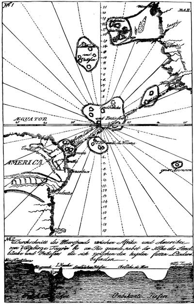
TRACES OF ATLANTIS.
Section of a map given in Briefe über Amerika aus dem Italienischen des Hn. Grafen Carlo Carli übersetzt, Dritter Theil (Gera, 1785), where it is called an “Auszug aus denen Karten welche der Pariser Akademie der Wissenschaften (1737, 1752) von dem Herrn von Buache übergeben worden sind.”
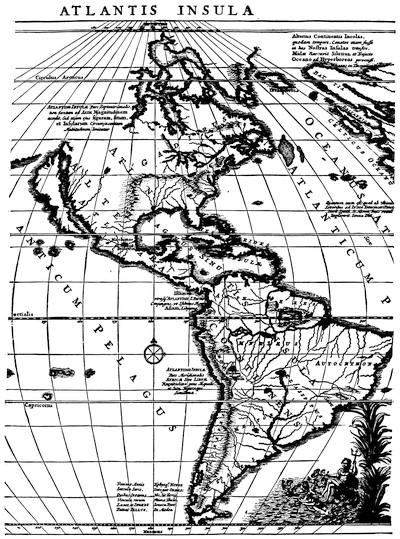
The annexed cut is an extract from Sanson’s map of America, showing views respecting the new world as constituting the Island of Atlantis. It is called: Atlantis insula à Nicolao Sanson, antiquitati restituta; nunc demum majori forma delineata, et in decem regna juxta decem Neptuni filios distributa. Præterea insulæ, nostræq. continentis regiones quibus imperavere Atlantici reges; aut quas armis tentavere, ex conatibus geographicis Gulielmi Sanson, Nicolai filii (Amstelodami apud Petrum Mortier). Uricoechea in the Mapoteca Colombiana puts this map under 1600, and speaks of a second edition in 1688, which must be an error. Nicholas Sanson was born in 1600, his son William died in 1703. Beside the undated Amsterdam print quoted above, Harvard College Library possesses a copy in which the words Novus orbis potius Altera continent sive are prefixed to the title, while the date MDCLXVIIII is inserted after filii. This copy was published by Le S. Robert at Paris in 1741.
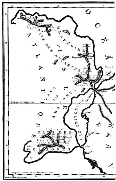
CARTE CONJECTURALE DE L’ATLANTIDE.
From a map in Bory de St. Vincent’s Essais sur les isles Fortunées, Paris [1803]. A map in Anastasius Kircher’s Mundus Subterraneus (Amsterdam, 1678), i. 82, shows Atlantis as a large island midway between the pillars of Hercules and America.
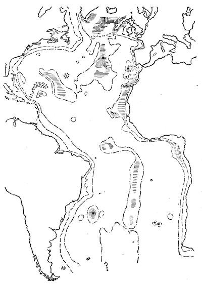
CONTOUR CHART OF THE BOTTOM OF THE ATLANTIC.
Sketched from the colored map of the United States Hydrographic office, as given in Alexander Agassiz’s Three Cruises of the Blake (Cambridge, 1888), vol. i. The outline of the continents is shown by an unbroken line. The 500 fathom shore line is a broken one (—— —— —— ——). The 2,000 fathom shore line is made by a dash and dot (——.——.——.——). The large areas in mid-ocean enclosed by this line, have this or lesser depths. Of the small areas marked by this line, the depth of 2,000 fathoms or less is within these areas in all cases except as respects the small areas on the latitude of Newfoundland, where the larger areas of 2,000 fathoms’ depth border on the small areas of greater depth. Depths varying from 1,500 to 1,000 fathoms are shown by horizontal lines; from 1,000 to 500 by perpendicular lines; and the crossed lines show the shallowest spots in mid-ocean of 500 fathoms or less. The areas of greatest depth (over 3,500 fathoms) are marked with crosses.
Such is the tale of Atlantis. Read in Plato, the nature and meaning of the narrative seem clear, but the commentators, ancient and modern, have made wild work. The voyage of Odysseus has grown marvellously in extent since he abandoned the sea; Io has found the pens of the learned more potent goads than Hera’s gadfly; but the travels of Atlantis have been even more extraordinary. No region has been so remote, no land so opposed by location, extent, or history to the words of Plato, but that some acute investigator has found in it the origin of the lost island. It has been identified with Africa, with Spitzbergen, with Palestine. The learned Latreille convinced himself that Persia best fulfilled the conditions of the problem; the more than learned Rudbeck ardently supported the claims of Sweden through three folios. In such a search America could not be overlooked. Gomara, Guillaume de Postel, Wytfliet, are among those who have believed that this continent was Atlantis; Sanson in 1669, and Vaugondy in 1762, ventured to issue a map, upon which the division of that island among the sons of Neptune was applied to America, and the outskirts of the lost continent were extended even to New Zealand. Such work, of course, needs no serious consideration. Plato is our authority, and Plato declares that Atlantis lay not far west from Spain, and that it disappeared some 8,000 years before his day. An inquiry into the truth or meaning of the record as it stands is quite justifiable, and has been several times undertaken, with divergent results. Some, notably Paul Gaffarel[299] and Ignatius Donnelly,[300] are convinced that Plato merely adapted to his purposes a story which Solon had actually brought from Egypt, and which was in all essentials true. Corroboration of the existence of such an island in the Atlantic is found, according to these writers, in the physical conformation of the Atlantic basin, and in marked resemblances between the flora, fauna, civilization, and language of the old and new worlds, which demand for their explanation the prehistoric existence of just such a bridge as Atlantis would have supplied. The Atlantic islands are the loftiest peaks and plateaus of the submerged island. In the widely spread deluge myths Mr. Donnelly finds strong confirmation of the final cataclysm; he places in Atlantis that primitive culture which M. Bailly sought in the highlands of Asia, and President Warren refers to the north pole. Space fails for a proper examination of the matter, but these ingenious arguments remain somewhat top-heavy when all is said. The argument from ethnological resemblances is of all arguments the weakest in the hands of advocates. It is of value only when wielded by men of judicial temperament, who can weigh difference against likeness, and allow for the narrow range of nature’s moulds. The existence of the ocean plateaus revealed by the soundings of the “Dolphin” and the “Challenger” proves nothing as to their having been once raised above the waves; the most of the Atlantic islands are sharply cut off from them. Even granting the prehistoric migration of plants and animals between America and Europe, as we grant it between America and Asia, it does not follow that it took place across the mid-ocean, and it would still be a long step from the botanic “bridge” and elevated “ridge” to the island empire of Plato. In short, the conservative view advocated by Longinus, that the story was designed by Plato as a literary ornament and a philosophic illustration, is no less probable to-day than when it was suggested in the schools of Alexandria. Atlantis is a literary myth, belonging with Utopia, the New Atlantis, and the Orbis alter et idem of Bishop Hall.
Of the same type is a narrative which has come down indirectly, among the flotsam and jetsam of classic literature: it is a fragment from a lost work by Theopompus of Chios, a historian of the fourth century b.c., found in the Varia Historia of Aelian, a compiler of the third century a.d.[301] The story is told by the satyr Silenus to Midas, king of Phrygia, and is, as few commentators have refrained from remarking, worthy the ears of its auditor.[302] “Selenus tolde Midas of certaine Islands, named Europa, Asia, and Libia, which the Ocean Sea circumscribeth and compasseth round about. And that without this worlde there is a continent or percell of dry lande, which in greatnesse (as hee reported) was infinite and unmeasurable, that it nourished and maintained, by the benifite of the greene medowes and pasture plots, sundrye bigge and mighty beastes; that the men which inhabite the same climats, exceede the stature of us twise, and yet the length of there life is not equale to ours.” Many other wonders he related of the two cities, Machimus, the warlike, and Euseues, the city of peace, and how the inhabitants of the former once made an attack upon Europe, and came first upon the Hyperboreans; but learning that they were esteemed the most holy of the dwellers in that island, they “had them in contempte, detesting and abhorring them as naughty people, of preposterous properties, and damnable behauiour, and for that cause interrupted their progresse, supposing it an enterprise of little worthinesse or rather none at al, to trauaile into such a countrey.” The concluding passage relating to the strange country inhabited by the Meropes, from whose name later writers have called the continent Meropian, bears only indirectly upon the subject, as characterizing the whole narrative.[303]
Without admitting the harsh judgment of Aelian, who brands Theopompus as a “coyner of lyes and a forger of fond fables,” it is clear that we are dealing here with literature, not with history, and that the identification of the land of the Meropes, or, as Strabo calls it, Meropis, with Atlantis or with America is arbitrary and valueless.[304]
The same remark applies to the account of the great Saturnian continent that closes the curious and interesting dialogue “On the Face appearing in the Orb of the Moon,” attributed to Plutarch, and printed with his Morals:
“‘An isle, Ogygia, lies in Ocean’s arms,’” says the narrator, “about five days’ sail west from Britain; and before it are three others, of equal distance from one another, and also from that, bearing northwest, where the sun sets in summer. In one of these the barbarians feign that Saturn is detained in prison by Zeus.” The adjacent sea is termed the Saturnian, and the continent by which the great sea is circularly environed is distant from Ogygia about five thousand stadia, but from the other islands not so far. A bay of this continent, in the latitude of the Caspian Sea, is inhabited by Greeks. These, who had been visited by Heracles, and revived by his followers, esteemed themselves inhabitants of the firm land, calling all others islanders, as dwelling in land encompassed by the sea. Every thirty years these people send forth certain of their number, who minister to the imprisoned Saturn for thirty years. One of the men thus sent forth, at the end of his service, paid a visit to the great island, as they called Europe. From him the narrator learned many things about the state of men after death, which he unfolds at length, the conclusion being that the souls of men ultimately arrive at the moon, wherein lie the Elysian Fields of Homer. “And you, O Lamprias,” he adds, “may take my relation in such part as you please.” After which hint there is, I think, but little doubt as to the way in which it should be taken by us.[305]
That Plato, Theopompus, and Plutarch, covering a range of nearly five centuries, should each have made use of the conception of a continent beyond the Atlantic, is noteworthy; but it is more naturally accounted for by supposing that all three had in mind the continental hypothesis of land distribution, than by assuming for them an acquaintance with the great western island, America. From this point of view, the result of our search into the geographical knowledge and mythical tales of the ancients is purely negative. We find, indeed, well-developed theories of physical geography, one of which accords remarkably well with the truth; but we also find that these theories rest solely on logical deductions from the mathematical doctrine of the sphere, and on an aesthetic satisfaction with symmetry and analogy. This conclusion could be invalidated were it shown that exploration had already revealed the secrets of the west, and we must now consider this branch of the subject.
The history of maritime discovery begins among the Phœnicians. The civilization of Egypt, as self-centred as that of China, accepted only the commerce that was brought to its gates; but the men of Sidon and Tyre, with their keen devotion to material interests, their almost modern ingenuity, had early appropriated the carrying trade of the east and the west. As they looked adventurously seaward from their narrow domain, the dim outline of Cyprus beckoned them down a long lane of island stations to the rich shores of Spain. Even their religion betrayed their bent: El and Cronos, their oldest deities, were wanderers, and vanished in the west; on their traces Melkarth led a motley swarm of colonists to the Atlantic. These legends, filtering through Cyprus, Crete, or Rhodes, or borne by rash adventurers from distant Gades, appeared anew in Grecian mythology, the deeds of Melkarth mingling with the labors of Hercules. We do not know when the Phœnicians first reached the Atlantic, nor what were the limits of their ocean voyages. Gades, the present Cadiz, just outside the Straits of Gibraltar, was founded a few years before 1100 b.c., but not, it is probable, without previous knowledge of the commercial importance of the location. There were numerous other settlements along the adjacent coast, and the gold, silver, and tin of these distant regions grew familiar in the markets of Egypt, Mesopotamia, and India. The trade with Tartessus, the El Dorado of antiquity, gave the Phœnician merchant vessels a name among the Jews, as well in the tenth century, when Solomon shared the adventures of Hiram, as in the sixth, when Ezekiel depicted the glories of Tyrian commerce. The Phœnician seamanship was wide-famed; their vessels were unmatched in speed,[306] and their furniture and discipline excited the outspoken admiration of Xenophon. Beside the large Tarshish ships, they possessed light merchant vessels and ships of war, provided with both sails and oars, and these, somewhat akin to steamships in their independence of wind, were well adapted for exploration. Thus urged and thus provided, it is improbable that the Phœnicians shunned the great ocean. The evidence is still strong in favor of their direct trade with Britain for tin, despite what has been urged as to tin mines in Spain and the prehistoric existence of the trade by land across Gaul.[307]
Whether the Tyrians discovered any of the Atlantic islands is unknown; the adventures and discoveries attributed to Hercules, who in this aspect is but Melkarth in Grecian raiment, points toward an early knowledge of western islands, but these myths alone are not conclusive proof. Diodorus Siculus attributes to the Phœnicians the discovery, by accident, of a large island, with navigable rivers and a delightful climate, many days’ sail westward from Africa. In the compilation De Mirabilibus Auscultationibus, printed with the works of Aristotle, the discovery is attributed to Carthaginians. Both versions descend from one original, now lost, and it is impossible to give a date to the event, or to identify the locality.[308] Those who find America in the island of Diodorus make improbabilities supply the lack of evidence. Stories seldom lose in the telling, and while it is not impossible that a Phœnician ship might have reached America, and even made her way back, it is not likely that the voyage would have been tamely described as of many days’ duration.
When Carthage succeeded Tyre as mistress of the Mediterranean commerce, interest in the West revived. In the middle of the fifth century b.c., two expeditions of importance were dispatched into these waters. A large fleet under Hanno sailed to colonize, or re-colonize, the western coast of Africa, and succeeded in reaching the latitude of Sierra Leone. Himilko, voyaging in the opposite direction, spent several months in exploring the ocean and tracing the western shores of Europe. He appears to have run into the Sargasso Sea, but beyond this little is known of his adventures.[309]
Ultimately the Carthaginians discovered and colonized the Canary Islands, and perhaps the Madeira and Cape Verde groups; the evidence of ethnology, the presence of Semitic inscriptions, and the occurrence in the descriptions of Pliny, Mela, and Ptolemy of some of the modern names of the separate islands, establishes this beyond a doubt for the Canaries.[310] There is no evidence that the Phœnicians or Carthaginians penetrated much beyond the coast islands, or that they reached any part of America, or even the Azores.
The achievements of the Greeks and Romans were still more limited. A certain Colaeus visited Gades towards the middle of the seventh century B.C., and was, according to Herodotus, the first Greek who passed outside of the columns of Hercules. His example could not have been widely followed, for we find Pindar and his successors referring to the Pillars as the limit of navigation. In 600 b.c., Massilia was founded, and soon became a rival of Carthage in the western Mediterranean. In the fourth century we have evidence of an attempt to search out the secrets of the ocean after the manner of Hanno and Himilko. In that century, Pytheas made his famous voyage to the lands of tin and amber, discovering the still mysterious Thule; while at the same time his countryman Euthymenes sailed southward to the Senegal. With these exceptions we hear of no Grecian or Roman explorations in the Atlantic, and meet with no indication that they were aware of any other lands beyond the sea than the Fortunate Isles or the Hesperides of the early poets.[311]
About 80 b.c., Sertorius, being for a time driven from Spain by the forces of Sulla, fell in, when on an expedition to Baetica, with certain sailors who had just returned from the “Atlantic islands,” which they described as two in number, distant 10,000 stadia from Africa, and enjoying a wonderful climate. The account in Plutarch is quite consistent with a previous knowledge of the islands, even on the part of Sertorius. Be this as it may, the glowing praises of the eye-witnesses so impressed him that only the unwillingness of his followers prevented his taking refuge there. Within the next few years, the Canaries, at least, became well known as the Fortunatae Insulae; but when Horace, in the dark days of civil war, urged his countrymen to seek a new home across the waves, it was apparently the islands of Sertorius that he had in mind, regarding them as unknown to other peoples.[312]
As we trace the increasing volume and extent of commerce from the days of Tyre and Carthage and Alexandria to its fullest development under the empire, and remember that as the drafts of luxury-loving Rome upon the products of the east, even of China and farther India, increased, the true knowledge of the form of the earth, and the underestimate of the breadth of the western ocean, became more widely known, the question inevitably suggests itself, Why did not the enterprise which had long since utilized the monsoons of the Indian Ocean for direct passage to and from India essay the passage of the Atlantic? The inquiry gains force as we recall that the possibility of such a route to India had been long ago asserted. Aristotle suggested, if he did not express it; Eratosthenes stated plainly that were it not for the extent of the Atlantic it would be possible to sail from Spain to India along the same parallel;[313] and Strabo could object nothing but the chance of there being another island-continent or two in the way,—an objection unknown to Columbus. Seneca, the philosopher, iterating insistence upon the smallness of the earth and the pettiness of its affairs compared with the higher interests of the soul, exclaims: “The earth, which you so anxiously divide by fire and sword into kingdoms, is a point, a mere point, in the universe.... How far is it from the utmost shores of Spain to those of India? But very few days’ sail with a favoring wind.”[314]
Holding these views of the possibility of the voyage, it is improbable that the size of their ships and the lack of the compass could have long prevented the ancients from putting them in practice had their interest so demanded.[315] Their interest in the matter was, however, purely speculative, since, under the unity and power of the Roman empire, which succeeded to and absorbed the commercial supremacy of the Phœnicians, international competition in trade did not exist, nor were the routes of trade subject to effective hostile interruption. The two causes, therefore, which worked powerfully to induce the voyages of Da Gama and Columbus, after the rise of individual states had given scope to national jealousy and pride, and after the fall of Constantinople had placed the last natural gateway of the eastern trade in the hands of Arab infidels, were non-existent under the older civilization. It is certain, too, that the ancients had a vivid horror of the western ocean. In the Odyssey, the western Mediterranean even is full of peril. With knowledge of the ocean, the Greeks received tales of “Gorgons and Chimeras dire,” and the very poets who sing the beauties of the Elysian or Hesperian isles dwell on the danger of the surrounding sea. Beyond Gades, declared Pindar, no man, however brave, could pass; only a god might voyage those waters. The same idea recurs in the reports of travellers and the writings of men of science, but here it is the storms, or more often the lack of wind, the viscid water or vast shoals, that check and appall the mariner. Aristotle thought that beyond the columns the sea was shallow and becalmed. Plato utilized the common idea of the mudbanks and shoal water of the Atlantic in accounting for the disappearance of Atlantis. Scylax reported the ocean not navigable beyond Cerne in the south, and Pytheas heard that beyond Thule sea and air became confounded. Even Tacitus believed that there was a peculiar resistance in the waters of the northern ocean.[316]
Whether the Greeks owed this dread to the Phœnicians, and whether the latter shared the feeling, or simulated and encouraged it for the purpose of concealing their profitable adventures beyond the Straits, is doubtful. In two cases, at least, it is possible to trace statements of this nature to Punic sources, and antiquity agreed in giving the Phœnicians credit for discouraging rivalry by every art.[317]
To an age averse to investigation for its own sake, ignorant of scientific curiosity, and unimpelled by economic pressure, tales like these might seem decisive against an attempt to sail westward to India. Rome could thoroughly appreciate the imaginative mingling of science and legend which vivified the famous prophecy of the poet Seneca:
Venient annis saecula seris Quibus Oceanus vincula rerum Laxet, et ingens patebit tellus Tethysque novos deteget orbes Nec sit terris ultima Thule.[318]
But even were it overlooked that the prophecy suited better the revelation of an unknown continent, such as the theory of Crates and Cicero placed between Europe and Asia, than the discovery of the eastern coast of India, mariners and merchants might be pardoned if they set the deterrent opinions collected by the elder Seneca above the livelier fancies of his son.[319]
The scanty records of navigation and discovery in the western waters confirm the conclusions drawn from the visions of the poets and the theories of the philosophers. No evidence from the classic writers justifies the assumption that the ancients communicated with America. If they guessed at the possibility of such a continent, it was only as we to-day imagine an antarctic continent or an open polar sea. Evidence from ethnological comparisons is of course admissible, but those who are best fitted to handle such evidence best know its dangers; hitherto its use has brought little but discredit to the cause in which it was invoked.
The geographical doctrines which antiquity bequeathed to the Middle Ages were briefly these: that the earth was a sphere with a circumference of 252,000 or 180,000 stadia; that only the temperate zones were inhabitable, and the northern alone known to be inhabited; that of the southern, owing to the impassable heats of the torrid zone, it could not be discovered whether it were inhabited, or whether, indeed, land existed there; and that of the northern, it was unknown whether the intervention of another continent, or only the shoals and unknown horrors of the ocean, prevented a westward passage from Europe to Asia. The legatee preserved, but did not improve his inheritance. It has been supposed that the early Middle Ages, under the influence of barbarism and Christianity, ignored the sphericity of the earth, deliberately returning to the assumption of a plane surface, either wheel-shaped or rectangular. That knowledge dwindled after the fall of the empire, that the early church included the learning as well as the religion of the pagans in its ban, is undeniable; but on this point truth prevailed. It was preserved by many school-books, in many popular compilations from classic authors, and was accepted by many ecclesiastics. St. Augustine did not deny the sphericity of the earth. It was assumed by Isidor of Seville, and taught by Bede.[320] The schoolmen buttressed the doctrine by the authority of Aristotle and the living science which the Arabs built upon the Almagest. Gerbert, Albert the Great, Roger Bacon, Dante, were as familiar with the idea of the earth-globe as were Hipparchus and Ptolemy. The knowledge of it came to Columbus not as an inspiration or an invention, but by long, unbroken descent from its unknown Grecian, or pre-Grecian, discoverer.
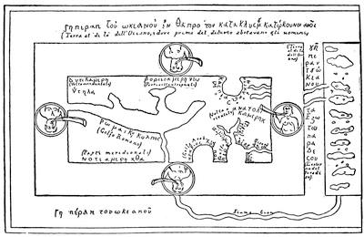
THE RECTANGULAR EARTH.
Sketched in the Bollettino della Società geografica italiana (Roma, 1882), p. 540, from the original in the Biblioteca Medicea Laurenziana in Florence. The representation of this sketch of the earth by Cosmas Indicopleustes more commonly met with is from the engraving in the edition of Cosmas in Montfaucon’s Collectio nova patrum, Paris, 1706. The article by Marinelli which contains the sketch given here has also appeared separately in a German translation (Die Erdkunde bei den Kirchenvätern, Leipzig, 1884). The continental land beyond the ocean should be noticed.
As to the distribution of land and water, the oceanic theory of Crates, as expounded by Macrobius, prevailed in the west, although the existence of antipodes fell a victim to the union, in the ecclesiastic mind, of the heathen theory of an impassable torrid zone with the Christian teaching of the descent of all men from Adam.[321] The discoveries made by the ancients in the ocean, of the Canaries and other islands known to them, were speedily forgotten, while their geographic myths were superseded by a ranker growth. The Saturnian continent, Meropis, Atlantis, the Fortunate Isles, the Hesperides, were relegated to the dusty realm of classical learning; but the Atlantic was not barren of their like. Mediæval maps swarmed with fabulous islands, and wild stories of adventurous voyages divided the attention with tales of love and war. Antillia was the largest, and perhaps the most famous, of these islands; it was situated in longitude 330° east, and near the latitude of Lisbon, so that Toscanelli regarded it as much facilitating the plan of Columbus. Well known, too, was Braçir, or Brazil, having its proper position west and north of Ireland, but often met with elsewhere; both this island and Antillia afterward gave names to portions of the new continent.[322]
Antillia, otherwise called the Island of Seven Cities, was discovered and settled by an archbishop and six bishops of Spain, who fled into the ocean after the victory of the Moors, in 714, over Roderick; it is even reported to have been rediscovered in 1447.[323] Mayda, Danmar, Man Satanaxio, Isla Verde, and others of these islands, of which but little is known beside the names, appear for the first time upon the maps of the fourteenth and fifteenth centuries, but their origin is quite unknown. It might be thought that they were derived from confused traditions of their classical predecessors, with which they have been identified, but modern folk-lore has shown that such fancies spring up spontaneously in every community. To dream of a distant spot where joy is untroubled and rest unbroken by grief or toil is a natural and inalienable bent of the human mind. Those happy islands which abound in the romances of the heathen Celts, Mag Mell, Field of Delight, Flath Inis, Isle of the Heroes, the Avallon of the Arthur cycle, were but a more exuberant forth-putting of the same soil that produced the Elysian Fields of Homer or the terrestrial paradise of the Hebrews. The later growth is not born of the seed of the earlier, though somewhat affected by alien grafts, as in the case of the famous island of St. Brandan, where there is a curious commingling of Celtic, Greek, and Christian traditions. It is dangerous, indeed, to speak of earlier or later in reference to such myths; one group was written before the others, but it is quite possible that the earthly paradise of the Celt is as old as those of the Mediterranean peoples. The idea of a phantom or vanishing island, too, is very old,—as old, doubtless, as the fact of fog-banks and mirage,—and it is well exemplified in those mysterious visions which enticed the sailors of Bristol to many a fruitless quest before the discovery of America, and for centuries tantalized the inhabitants of the Canaries with hope of discovery. The Atlantic islands were not all isles of the blessed; there were many Isles of Demons, such as Ramusio places north of Newfoundland, a name of evil report which afterward attached itself with more reason to Sable Island and even to the Bermudas:
“Kept, as suppos’d by Hel’s infernal dogs; Our fleet found there most honest courteous hogs.”[324]
Not until the revival of classical learning did the continental system of Ptolemy reach the west; the way, however, had been prepared for it. The measurement of a degree, executed under the Calif Mamun, seemed to the Europeans to confirm the smallest estimate of the size of the earth, which Ptolemy also had adopted,[325] while the travels of Marco Polo, revealing the great island of Japan, exaggerated the popular idea of the extent of the known world, until the 225° of Marinus seemed more probable than the 180° of Ptolemy. If, however, time brought this shrinkage in the breadth of the Atlantic, the temptation to navigators was opposed by the belief in the dangers of the ocean, which shared the persistent life of the dogma of the impassable torrid zone, and was strongly reinforced by Arab lore. Their geographers never tire of dilating on the calms and storms, mudbanks and fogs, and unknown dangers of the “Sea of Darkness.” Nevertheless, as the turmoil of mediæval life made gentler spirits sigh for peace in distant homes, while the wild energy of others found the very dangers of the sea delightful, there was opened a double source of adventures, both real and imaginary. Those pillars cut with inscriptions forbidding further advance westward, which we owe to Moorish fancy, confounding Hercules and Atlas and Alexander, were transformed into a knightly hero pointing oceanwards, or became guide-posts to the earthly paradise.
If there be a legendary flavor in the flight of the seven bishops, we must set down the wanderings of the Magrurin[326] among the African islands, the futile but bold attempts of the Visconti to circumnavigate Africa, as real, though without the least footing in a list of claimants for the discovery of America. The voyages of St. Brandan and St. Malo, again, are distinctly fabulous, and but other forms of the ancient myth of the soul-voyages; and the same may be said of the strange tale of Maelduin.[327] But what of those other Irish voyages to Irland-it-mikla and Huitramannaland, of the voyage of Madoc, of the explorations of the Zeni? While these tales merit close investigation, it is certain that whatever liftings of the veil there may have been—that there were any is extremely doubtful—were unheralded at the time and soon forgotten.[328]
It was reserved for the demands of commerce to reveal the secrets of the west. But when the veil was finally removed it was easy for men to see that it had never been quite opaque. The learned turned naturally to their new-found classics, and were not slow to find the passages which seemed prophetic of America. Seneca, Virgil, Horace, Aristotle, and Theopompus, were soon pressed into the service, and the story of Atlantis obtained at once a new importance. I have tried to show in this chapter that these patrons of a revived learning put upon these statements an interpretation which they will not bear.
The summing up of the whole matter cannot be better given than in the words applied by a careful Grecian historian to another question in ancient geography: “In some future time perhaps our pains may lead us to a knowledge of those countries. But all that has hitherto been written or reported of them must be considered as mere fable and invention, and not the fruit of any real search, or genuine information.”[329]

CRITICAL ESSAY ON THE SOURCES OF INFORMATION.
THE views of the ancient Mediterranean peoples upon geography are preserved almost solely in the ancient classics. The poems attributed to Homer and Hesiod, the so-called Orphic hymns, the odes of Pindar, even the dramatic works of Æschylus and his successors, are sources for the earlier time. The writings of the earlier philosophers are lost, and their ideas are to be found in later writers, and in compilations like the Biographies of Diogenes Laertius (3d cent. a.d.), the De placitis philosophorum attributed to Plutarch, and the like. Among the works of Plato the Phaedo and Timaeus and the last book of the Republic bear on the form and arrangement of the earth; the Timaeus and Critias contain the fable of Atlantis. The first scientific treatises preserved are the De Caelo and Meteorologica of Aristotle.[330] It is needless to speak in detail of the geographical writers, accounts of whom will be found in any history of Greek and Roman literature. The minor pieces, such as the Periplus of Hanno, of Scylax of Caryanda, of Dionysius Periegetes, the Geography of Agatharcides, and others, have been several times collected;[331] and so have the minor historians, which may be consulted for Theopompus, Hecataeus, and the mythologists.[332] The geographical works of Pytheas (b.c. 350?), of Eratosthenes (b.c. 276-126), of Polybius (b.c. 204-122), of Hipparchus (flor. circ. b.c. 125), of Posidonius (1st cent. b.c.), are preserved only in quotations made by later writers; they have, however, been collected and edited in convenient form.[333] The most important source of our knowledge of Greek geography and Greek geographers is of course the great Geography of Strabo, which a happy fortune preserved to us. The long introduction upon the nature of geography and the size of the earth and the dimensions of the known world is of especial interest, both for his own views and for those he criticises.[334] Strabo lived about b.c. 60 to a.d. 24.
The works of Marinus of Tyre having perished, the next important geographical work in Greek is the world-renowned Geography of Ptolemaeus, who wrote in the second half of the second century a.d. Despite the peculiar merits and history of this work, it is not so important for our purpose as the work of Strabo, though it exercised infinitely more influence on the Middle Ages and on early modern geography.[335]
The astronomical writers are also of importance. Eudoxus of Cnidus, said to have first adduced the change in the altitude of stars accompanying a change of latitude as proof of the sphericity of the earth, wrote works now known only in the poems of Aratus, who flourished in the latter half of the third century b.c.[336] Geminus (circ. b.c. 50),[337] and Cleomedes,[338] whose work is famous for having preserved the method by which Eratosthenes measured the circumference of the earth, were authors of brief popular compilations of astronomical science. Of vast importance in the history of learning was the astronomical work of Ptolemy, ἡ μεγάλη σύνταξις τῆς ἀστρονομίας, which was so honored by the Arabs that it is best known to us as the Almagest, from Tabric al Magisthri, the title of the Arabic translation which was made in 827. It has been edited and translated by Halma (Paris, 1813, 1816).
Much is to be learned from the Scholia attached in early times to the works of Hesiod, Homer, Pindar, the Argonautica of Apollonius Rhodius (b.c. 276-193?), and to the works of Aristotle, Plato, etc. In some cases these are printed with the works commented upon; in other cases, the Scholia have been printed separately. The commentary of Proclus (a.d. 412-485) upon the Timaeus of Plato is of great importance in the Atlantis myth.[339]
Much interest attaches to the dialogue entitled On the face appearing in the orb of the moon, which appears among the Moralia of Plutarch. Really a contribution to the question of life after death, this work also throws light upon geographical and astronomical knowledge of its time.
Among the Romans we find much the same succession of sources. The poets, Virgil, Horace, Ovid, Tibullus, Lucretius, Lucan, Seneca, touch on geographical or astronomical points and reflect the opinion of their day.[340]
The first six books of the great encyclopaedia compiled by Pliny the elder (a.d. 23-79)[341] contain an account of the universe and the earth, which is of the greatest value, and was long exploited by compilers of later times, among the earliest and best of whom was Solinus.[342] Equally famous with Solinus was the author of a work of more independent character, Pomponius Mela, who lived in the first century a.d. His geography, commonly known as De situ orbis from the mediæval title, though the proper name is De chorographia, is a work of importance and merit. In the Middle Ages it had wonderful popularity.[343] Cicero, who contemplated writing a history of geography, touches upon the arrangement of the earth’s surface several times in his works, as in the Tusculan Disputations, and notably in the sixth book of the Republic, in the episode known as the “Dream of Scipio.” The importance of this piece is enhanced by the commentary upon it written by Macrobius in the fifth century a.d.[344] A peculiar interest attaches to the poems of Avienus, of the fourth century a.d., in that they give much information about the character attributed to the Atlantic Ocean.[345] The astronomical poems of Manilius[346] and Hyginus were favorites in early Middle Ages. The astrological character of the work of Manilius made it popular, but it conveyed also the true doctrine of the form of the earth. The curious work of Marcianus Capella gave a résumé of science in the first half of the fifth century a.d., and had a like popularity as a school-book and house-book which also helped maintain the truth.[347]
Such in the main are the ancient writers upon which we must chiefly rely in considering the present question. In the interpretation of these sources much has been done by the leading modern writers on the condition of science in ancient times; like Bunbury, Ukert, Forbiger, St. Martin, and Peschel on geography;[348] like Zeller on philosophy, not to name many others;[349] and like Lewis and Martin on astronomy;[350] but there is no occasion to go to much length in the enumeration of this class of books. The reader is referred to the examination of the literature of special points of the geographical studies of the ancients to the notes following this Essay.
Mediæval cosmology and geography await a thorough student; they are imbedded in the wastes of theological discussions of the Fathers, or hidden in manuscript cosmographies in libraries of Europe. It should be noted that confusion has arisen from the use of the word rotundus to express both the sphericity of the earth and the circularity of the known lands, and from the use of terra, or orbis terrae, to denote the inhabited lands, as well as the globe. It has been pointed out by Ruge (Gesch. d. Zeitalters der Entdeckungen, p. 97) that the later Middle Age adopted the circular form of the oekoumene in consequence of a peculiar theory as to the relation of the land and water masses of the earth, which were conceived as two intercepting spheres. The oekoumene might easily be spoken of as a round disk without implying that the whole earth was plane.[351] That the struggle of the Christian faith, at first for existence and then for the proper harvesting of the fruits of victory, induced its earlier defenders to wage war against the learning as well as the religion of the pagans; that Christians were inclined to think time taken from the contemplation of the true faith worse than wasted when given to investigations into natural phenomena, which might better be accepted for what they professed to be; and that they often found in Scripture a welcome support for the evidence of the senses,—cannot be denied. It was inevitable that St. Chrysostom, Lactantius, Orosius and Origines rejected or declined to teach the sphericity of the earth. The curious systems of Cosmas and Aethicus, marked by a return to the crudest conceptions of the universe, found some favor in Europe. But the truth was not forgotten. The astronomical poems of Aratus, Hyginus, and Manilius were still read. Solinus and other plunderers of Pliny were popular, and kept alive the ancient knowledge. The sphericity of the earth was not denied by St. Augustine; it was maintained by Martianus Capella, and assumed by Isidor of Seville. Bede[352] taught the whole system of ancient geography; and but little later, Virgilius, bishop of Saltzburg, was threatened with papal displeasure, not for teaching the sphericity of the earth, but for upholding the existence of antipodes.[353] The canons of Ptolemy were cited in the eleventh century by Hermann Contractus in his De utilitatibus astrolabii, and in the twelfth by Hugues de Saint Victor in his Eruditio didascalica. Strabo was not known before Pope Nicholas V., who ordered the first translation. Not many to-day can illustrate the truth more clearly than the author of L’Image du Monde, an anonymous poem of the thirteenth century. If two men, he says, were to start at the same time from a given point and go, the one east, the other west,—
Si que andui egaumont alassent Il convendroit qu’il s’encontrassent Dessus le leu dont il se mûrent.[354]
In general, the mathematical and astronomical treatises were earlier known to the West than the purely metaphysical works: this was the case in the eleventh and twelfth centuries; in the thirteenth the schoolmen were familiar with the whole body of Aristotle’s works. Thus the influence of Aristotle on natural science was early important, either through Arabian commentators or paraphrasers, or through translations made from the Arabic, or directly from the Greek.[355]
Jourdain affirms that it was the influence of Aristotle and his interpreters that kept alive in the Middle Ages the doctrine that India and Spain were not far apart. He also maintains that the doctrine of the sphericity of the earth was familiar throughout the Middle Age, and, if anything, more of a favorite than the other view.
The field of the later ecclesiastical and scholastic writers, who kept up the contentions over the form of the earth and kindred subjects, is too large to be here minutely surveyed. Such of them as were well known to the geographical students of the centuries next preceding Columbus have been briefly indicated in another place;[356] and if not completely, yet with helpful outlining, the whole subject of the mediæval cosmology has been studied by not a few of the geographical and cartographical students of later days.[357] So far as these studies pertain to the theory of a Lost Atlantis and the fabulous islands of the Atlantic Ocean, they will be particularly illustrated in the notes which follow this Essay.

NOTES.
I cannot attach much importance to the line of argument with which modern writers since Voss have tried to prove that the Homeric poems represent the earth flat. That Poseidon, from the mountains of the Solymi, sees Odesseus on the sea to the west of Greece (Od. v. 282); that Helios could see his cattle in Thrinakia both as he went toward the heavens and as he turned toward the earth again (Od. xii. 380); that at sunset “all the ways are darkened;” that the sun and the stars set in and rose from the ocean,—these and similar proofs seem to me to have as little weight as attaches to the expressions “ends of the earth,” or to the flowing of Oceanus around the earth. There are, however, other and better reasons for assuming that the earth in earliest thought was flat. Such is the most natural assumption from the evidence of sight, and there is certainly nothing in the older writings inconsistent with such an idea. We know, moreover, that in the time of Socrates it was yet a matter of debate as to whether the earth was flat or spherical, as it was in the time of Plutarch.[359] We are distinctly told by Aristotle that various forms were attributed to earth by early philosophers, and the implication is that the spherical theory, whose truth he proceeds to demonstrate, was a new thought.[360] It is very unlikely, except to those who sincerely accept the theory of a primitive race of unequalled wisdom, that the sphericity of the earth, having been known to Homer, should have been cast aside by the Ionic philosophers and the Epicureans, and forgotten by educated people five or six centuries later, as it must have been before the midnight voyage of Helios in his golden cup, and before similar attempts to account for the return of the sun could have become current. Ignorance of the true shape of the earth is also indicated by the common view that the sun appeared much larger at rising to the people of India than to the Grecians, and at setting presented the same phenomenon in Spain.[361] As we have seen, the description of Tartarus in the Theogony of Hesiod, which Fick thinks an interpolation of much later date, likens the earth to a lid.
The question has always been an open one. Crates of Mallos, Strabo, and other Homer-worshippers of antiquity, could not deny to the poet any knowledge current in their day, but their reasons for assuming that he knew the earth to be a globe are not strong. In recent years President Warren has maintained that Homer’s earth was a sphere with Oceanus flowing around the equator, that the pillars of Atlas meant the axis of the earth, and that Ogygia was at the north pole.[362] Homer, however, thought that Oceanus flowed around the known lands, not that it merely grazed their southern border: it is met with in the east where the sun rises, in the west (Od. iv. 567), and in the north (Od. v. 275).
That “Homer and all the ancient poets conceived the earth to be a plane” was distinctly asserted by Geminus in the first century b.c.,[363] and has been in general steadfastly maintained by moderns like Voss,[364] Völcker,[365] Buchholtz,[366] Gladstone,[367] Martin,[368] Schaefer,[369] and Gruppe.[370] It is therefore intrinsically probable, commonly accepted, and not contradicted by what is known of the literature of the time itself.[371]
In the seventeenth and eighteenth centuries it was not an uncommon subject of academic and learned discussion.[375] It was a part of the survey made by many of the writers who discussed the origin of the American tribes, like Garcia,[376] Lafitau,[377] Samuel Mather,[378] Robertson,[379] not to name others.
It was not till Humboldt compassed the subject in his Examen Critique de l’histoire de la géographie du nouveau continent (Paris, 1836), that the field was fully scanned with a critical spirit, acceptable to the modern mind. He gives two of the five volumes which comprise the work to this part of his subject, and very little has been added by later research, while his conclusions still remain, on the whole, those of the most careful of succeeding writers. The French original is not equipped with guides to its contents, such as a student needs; but this is partly supplied by the index in the German translation.[380] The impediments which the student encounters in the Examen Critique are a good deal removed in a book which is on the whole the easiest guide to the sources of the subject,—Paul Gaffarel’s Etude sur les rapports de l’Amérique et de l’ancien continent avant Christophe Colomb (Paris, 1869).[381]
The literature of the supposed old-world communication with America shows other phases of this question of ancient knowledge, and may be divided, apart from the Greek embraced in the previous survey, into those of the Egyptians, Phœnicians, Tyrians, Carthaginians, and Romans.
The Egyptian theory has been mainly worked out in the present century. Paul Felix Cabrera’s Teatro critico Americano, printed with Rio’s Palenqué (Lond., 1822), formulates the proofs. An essay by A. Lenoir, comparing the Central American monuments with those of Egypt, is appended to Dupaix’s Antiquités Méxicaines (1805). Delafield’s Inquiry into the Origin of the Antiquities of America (Cincinnati, 1839), traces it to the Cushites of Egypt, and cites Garcia y Cubas, Ensayo de an Estudio Comparativo entre las Pirámides Egipcias y Méxicanas. Brasseur de Bourbourg discussed the question, S’il existe des sources de l’histoire primitive du Méxique dans les monuments égyptiens de l’histoire primitive de l’ancien monde dans les monuments américains? in his ed. of Landa’s Relations des Choses de Yucatan (Paris, 1864). Buckle (Hist. of Civilization, i. ch. 2) believes the Mexican civilization to have been strictly analogous to that of India and Egypt. Tylor (Early Hist. of Mankind, 98) compares the Egyptian hieroglyphics with those of the Aztecs. John T. C. Heaviside, Amer. Antiquities, or the New World the Old, and the Old World the New (London, 1868), maintains the reverse theory of the Egyptians being migrated Americans. F. de Varnhagen works out his belief in L’origine touranienne des américains tupis-caribes et des anciens égyptiens montrée principalement par la philologie comparée; et notice d’une émigration en Amérique effectuée à travers l’Atlantique plusieurs siècles avant notre ère (Vienne 1876).[382]
Aristotle’s mention of an island discovered by the Phœnicians was thought by Gomara and Oviedo to refer to America. The elder leading writers on the origin of the Indians, like Garcia, Horn, De Laet, and at a later day Lafitau, discuss the Phœnician theory; as does Voss in his annotations on Pomponius Mela (1658), and Count de Gebelin in his Monde primitif (Paris, 1781). In the present century the question has been touched by Cabrera in Rio’s Palenqué (1822). R. A. Wilson, in his New Conquest of Mexico, assigns (ch. v.) the ruins of Middle America to the Phœnicians. Morlot, in the Actes de la Société Jurassienne d’Emulation (1863), printed his “La découverte de l’Amérique par les Phènicièns.” Gaffarel sums up the evidences in a paper in the Compte Rendu, Cong. des Amér. (Nancy), i. 93.[383]
The Tyrian theory has been mainly sustained by a foolish book, by a foolish man, An Original History of Anc. America (London, 1843), by Geo. Jones, later known as the Count Johannes (cf. Bancroft’s Native Races, v. 73).
The Carthaginian discovery rests mainly on the statements of Diodorus Siculus.[384]
Baron Zach in his Correspondenz undertakes to say that Roman voyages to America were common in the days of Seneca, and a good deal of wild speculation has been indulged in.[385]
In the Scholia to Plato’s Republic it is said that at the great Panathenaea there was carried in procession a peplum ornamented with representations of the contest between the giants and the gods, while on the peplum carried in the little Panathenaea could be seen the war of the Athenians against the Atlantides. Even Humboldt accepted this as an independent testimony in favor of the antiquity of the story; but Martin has shown that, apart from the total inconsistency of the report with the expressions of Plato, who places the narration of this forgotten deed of his countrymen at the celebration of the festival of the little Panathenaea, the scholiast has only misread Proclus, who states that the peplum depicted the repulse of the barbarians, i. e. Persians, by the Greeks.[393] To these passages it is customary to add references to the Meropian continent of Theopompus,[394] the Saturnian of Plutarch, the islands of Aristotle, Diodorus and Pausanias,—which is very much as if one should refer to the New Atlantis of Bacon as evidence for the existence of More’s Utopia.[395] Plutarch in his life of Solon attributes Solon’s having given up the idea of an epic upon Atlantis to his advanced age rather than to want of leisure; but there is nothing to show that he had any evidence beyond Plato that Solon ever thought of such a poem, and Plato does not say that Solon began the poem, though Plutarch appears to have so understood him.[396] Thus it seems more probable that all the references to Atlantis by ancient writers are derived from the story in Plato than that they are independent and corroborative statements.
With the decline of the Platonic school at Alexandria even the name of Atlantis readily vanished from literature. It is mentioned by Tertullian,[397] and found a place in the strange system of Cosmas Indicopleustes,[398] but throughout the Middle Ages little or nothing was known of it. That it was not quite forgotten appears from its mention in the Image du Monde, a poem of the thirteenth century, still in MS., where it is assigned a location in the Mer Betée (= coagulée).[399] Plato was printed in Latin in 1483, 1484, 1491, and in Greek in 1513, and in 1534 with the commentary of Proclus on the Timaeus.[400] The Timaeus was printed separately five times in the sixteenth century, and also in a French and an Italian translation.[401]
The discovery of America doubtless added to the interest with which the story was perused, and the old controversy flamed up with new ardor. It was generally assumed that the account given by Plato was not his invention. Opinions were, however, divided as to whether he had given a correct account. Of those who believed that he had erred as to the locality or as to the destruction of the island, some thought that America was the true Atlantis, while others, with whose ideas we have no concern here, placed Atlantis in Africa, Asia, or Europe, as prejudice led them. Another class of scholars, sensible of the necessity of adhering to the text of the only extant account, accepted the whole narrative, and endeavored to find in the geography of the Atlantic, or as indicated by the resemblances between the flora, fauna, and civilization of America and of the old world, additional reasons for believing that such an island had once existed, and had disappeared after serving as a bridge by which communication between the continents was for a time carried on. The discussion was prolonged over centuries, and is not yet concluded. The wilder theories have been eliminated by time, and the contest may now be said to be between those who accept Plato’s tale as true and those who regard it as an invention. The latter view is at present in favor with the most conservative and careful scholars, but the other will always find advocates. That Atlantis was America was maintained by Gomara, Guillaume de Postel, Horn, and others incidentally, and by Birchrod in a special treatise,[402] which had some influence even upon the geographer Cellarius. In 1669 the Sansons published a map showing America divided among the descendants of Neptune as Atlantis was divided, and even as late as 1762 Vaugondy reproduced it.[403] In his edition of Plato, Stallbaum expressed his belief that the Egyptians might have had some knowledge of America.[404] Cluverius thought the story was due to a knowledge of America.[405]
Very lately Hyde Clark has found in the Atlantis fable evidence of a knowledge of America: he does not believe in the connecting island Atlantis, but he holds that Plato misinterpreted some account of America which had reached him.[406] Except for completeness it is scarcely worth mentioning that Blackett, whose work can really be characterized by no other word than absurd, sees America in Atlantis.[407]
Here should be mentioned a work by Berlioux, which puts Euhemerus to the blush in the manner in which history with much detail is extorted from mythology.[408] He holds that Atlantis was the northwestern coast of Africa; that under Ouranos and Atlas, astronomers and kings, it was the seat of a great empire which had conquered portions of America and kept a lively commercial intercourse with that country.
Ortelius in several places speaks of the belief that America was the old Atlantis, and also attributes that belief to Mercator.[409]
That Atlantis might really have existed[410] and disappeared, leaving the Atlantic islands as remnants, was too evident to escape notice. Ortelius suggested that the island of Gades might be a fragment of Atlantis,[411] and the doctrine was early a favorite. Kircher, in his very curious work on the subterranean world, devotes considerable space to Atlantis, rejecting its connection with America, while he maintains its former existence, and holds that the Azores, Canaries, and other Atlantic islands were formerly parts thereof, and that they showed traces of volcanic fires in his day.[412]
Las Casas in his history of the Indies devoted an entire chapter to Atlantis, quoting the arguments of Proclus, in his commentary on Plato, in favor of the story, though he is himself more doubtful. He also cites confirmative passages from Philo and St. Anselm, etc. He considers the question of the Atlantic isles, and cites authorities for great and sudden changes in the earth’s surface.[413]
The same view was taken by Becman,[414] and Fortia D’Urban. Turnefort included America in the list of remnants; and De la Borde followed Sanson in extending Atlantis to the farthest Pacific islands.[415] Bory de St. Vincent,[416] again, limited Atlantis to the Atlantic, and gave on a map his ideas of its contour.
D’Avezac maintains this theory in his Iles africaines de l’Océan Atlantique,[417] p. 5-8. Carli devoted a large part of the second volume of his Lettere Americane to Atlantis, controverting Baily, who placed Atlantis in Spitzbergen. Carli goes at considerable length into the topographical and geological arguments in favor of its existence.[418] The early naturalists, when the doctrine of great and sudden changes in the earth’s surface was in favor, were inclined to look with acquiescence on this belief. Even Lyell confessed a temptation to accept the theory of an Atlantis island in the northern Atlantic, though he could not see in the Atlantic islands trace of a mid-Atlantic bridge.[419] About the middle of this century scholars in several departments of learning, accepting the evidences of resemblances between the product of the old and new world, were induced to turn gladly to such a connection as would have been offered by Atlantis; and the results obtained at about the same time by studies in the pre-Columbian traditions and civilization of Mexico were brought forward as supporting the same theory. That the Antilles were remnants of Atlantis; that the Toltecs were descendants from the panic-stricken fugitives of the great catastrophe, whose terrors were recorded in their traditions, as well as in those of the Egyptians, was ardently urged by Brasseur de Bourbourg.[420]
In 1859 Retzius announced that he found a close resemblance between the skulls of the Guanches of the Canaries and the Guaranas of Brazil, and recalled the Atlantis story to explain it.[421] In 1846 Forbes declared his belief in the former existence of a bridge of islands in the North Atlantic, and in 1856 Heer attempted to show the necessity of a similar connection from the testimony of palæontological botany.
In 1860, Unger deliberately advocated the Atlantis hypothesis to explain the likeness between the fossil flora of Europe and the living flora of America, enumerating over fifty similar species; and Kuntze found in the case of the tropical seedless banana, occurring at once in America before 1492 and in Africa, a strong evidence of the truth of the theory.[422]
A condensed review of the scientific side of the question is given by A. Boué in his article Ueber die Rolle der Veränderungen des unorganischen Festen im grossen Massstabe in der Natur.[423]
The deep-sea soundings taken in the Atlantic under the auspices of the governments of the United States, England, and Germany resulted in discoveries which gave a new impetus to the Atlantis theory. It was shown that, starting from the Arctic plateau, a ridge runs down the middle of the Atlantic, broadening toward the Azores, and contracting again as it trends toward the northeast coast of South America. The depth over the ridge is less than 1,000 fathoms, while the valleys on either side average 3,000; it is known after the U. S. vessel which took the soundings as the Dolphin ridge. A similar though more uniformly narrow ridge was found by the “Challenger” expedition (1873-76), extending from somewhat north of Ascension Island directly south between South America and Africa. It is known as the Challenger ridge. There is, beside, evidence for the existence of a ridge across the tropical Atlantic, connecting the Dolphin and Challenger ridges. Madeira, the Canaries, and the Cape Verde Islands are cut off from these ridges by a deep valley, but are connected by shoals with the continent. Upon the publication of the Challenger chart (Special Report, vii. 1876), those who favored the theory of communication between the continents were not slow to appropriate its disclosures in their interests (Nature, Dec. 21, 1876, xv. 158). In March, 1877, W. Stephen Mitchell delivered a lecture at South Kensington, wherein he placed in juxtaposition the theory of Unger and the revelations of the deep-sea soundings, when he announced, however, that he did not mean to assert that these ridges had ever formed a connecting link above water between the continents.[424] Others were less cautious,[425] but in general this interpretation did not commend itself as strongly to conservative men of science as it might have done a few years before, because such men were gradually coming to doubt the fact of changes of great moment in the earth’s surface, even those of great duration.
In 1869, M. Paul Gaffarel published his first treatise on Atlantis,[426] advocating the truth of the story, and in 1880 he made it the subject of deeper research, utilizing the facts which ocean exploration had placed at command.[427] This is the best work which has appeared upon this side of the question, and can only be set against the earlier work by Martin.[428] The same theory has been supported by D. P. de Novo y Colson, who went so far as to predict the ultimate recovery of some Atlantean manuscripts from submarine grottoes of some of the Atlantic islands,—a hope which surpasses Mr. Donnelly.[429]
Winchell found the theory too useful in his scheme of ethnology to be rejected,[430] but it was reserved for Ignatius Donnelly to undertake the arrangement of the deductions of modern science and the data of old traditions into a set argument for the truth of Plato’s story. His book,[431] in many ways a rather clever statement of the argument, so evidently presented only the evidence in favor of his view, and that with so little critical estimate of authorities and weight of evidence, that it attracted only uncomplimentary notice from the scientific press.[432] It was, however, the first long presentation of the case in English, and as such made an impression on many laymen. In 1882 was also published the second volume of the Challenger Narrative, containing a report by M. Renard on the geologic character of the mid-Atlantic island known as St. Paul’s rocks. The other Atlantic islands are confessedly of volcanic origin, and this, which laymen interpreted in favor of the Atlantis theory, militated with men of science against the view that they were remnants of a sunken continent. St. Paul’s, however, was, as noted by Darwin, of doubtful character, and Renard came to the conclusion that it was composed of crystalline schists, and had therefore probably been once overlaid by masses since removed.[433] This conclusion, which tended in favor of Atlantis, was controverted by A. Geikie[434] and by M. E. Wadsworth,[435] (the latter having personally inspected specimens,) on the ground that the rocks were volcanic in origin, and that, had they been schists, the inference of denudation would not follow. Dr. Guest declared that ethnologists have fully as good cause as the botanists to regard Atlantis as a fact.[436] A. J. Weise in treating of the Discoveries of America adopted the Atlantis fable unhesitatingly, and supposes that America was known to the Egyptians through that channel.[437]
That the whole story was invented by Plato as a literary ornament or allegorical argument, or that he thus utilized a story which he had really received from Egypt, but which was none the less a myth, was maintained even among the early Platonists, and was the view of Longinus. Even after the discovery of America many writers recognized the fabulous touch in it, as Acosta,[438] who thought, “being well considered, they are rediculous things, resembling rather to Ovid’s tales then a Historie of Philosophie worthy of accompt,” and “cannot be held for true but among children and old folkes”—an opinion adopted by the judicious Cellarius.[439]
Humboldt threw the weight of his great influence in favor of the mythical interpretation, though he found the germ of the story in the older geographic myth of the destruction of Lyctonia in the Mediterranean (Orph. Argonaut., 1274, etc.);[443] while Martin, in his work on the Timaeus, with great learning and good sense, reduced the story to its elements, concluding that such an island had never existed, the tale was not invented by Plato, but had really descended to him from Solon, who had heard it in Egypt.
Prof. Jowett regards the entire narrative as “due to the imagination of Plato, who could easily invent ‘Egyptians or anything else,’ and who has used the name of Solon ... and the tradition of the Egyptian priest to give verisimilitude to his story;”[444] and Bunbury is of the same opinion, regarding the story as “a mere fiction,” and “no more intended to be taken seriously ... than the tale of Er the Pamphylian.”[445] Mr. Archer-Hind, the editor of the only separate edition of the Timaeus which has appeared in England, thinks it impossible to determine “whether Plato has invented the story from beginning to end, or whether it really more or less represents some Egyptian legend brought home by Solon,” which seems to be a fitting conclusion to the whole matter.
The literature of the subject is widely scattered, but a good deal has been done bibliographically in some works which have been reserved for special mention here. The earliest is the Dissertation sur l’Atlantide, by Th. Henri Martin,[446] wherein, beside a carefully reasoned examination of the story itself and similar geographic myths, the opposing views of previous writers are set forth in the second section, Histoire des Systèmes sur l’Atlantide, pp. 258-280. Gaffarel has in like manner given a résumé of the literature, which comes down later than that of Martin, in the two excellent treatises which he has devoted to the subject; he is convinced of the existence of such an island, but his work is marked by such care, orderliness, and fulness of citations that it is of the greatest value.[447] The references in these treatises are made with intelligence, and are, in general, accurate and useful. That this is not the case with the work of Mr. Donnelly deprives the volume of much of the value which it might have had.[448]
In what way the fabulous islands of the Atlantic originated is not known, nor has the subject been exhaustively investigated. The islands of classical times, in part actual discoveries, in part born of confused reports of actual discoveries, and in part probably purely mythical, were very generally forgotten as ancient civilization declined.[453] The other islands which succeeded them were in part reminiscences of the islands known to the ancients or invented by them, and in part products of a popular mythology, as old perhaps as that of the Greeks, but until now unknown to letters. The writers who have dealt with these islands have treated them generally from the purely geographic point of view. The islands are known principally from maps, beginning with the fourteenth century, and are not often met with in descriptive works. Formaleoni, in his attempt to show that the Venetians had discovered the West Indies prior to Columbus, made studies of the older maps which naturally led him to devote considerable attention to these islands.[454]